Review

Ecology of Intertidal Rocky Shores Related to Examples of Coastal Geology across Phanerozoic Time

by
Markes E. Johnson
Department of Geosciences, Williams College, Williamstown, MA 01267, USA
J. Mar. Sci. Eng. 2024, 12(8), 1399; https://doi.org/10.3390/jmse12081399
Submission received: 4 July 2024 / Revised: 5 August 2024 / Accepted: 11 August 2024 / Published: 15 August 2024
(This article belongs to the Special Issue Feature Review Papers in Geological Oceanography)

Abstract

:
The boundary between land and sea is among the most extensive and extreme ecological barriers on planet Earth. Intertidal organisms living at this junction are subject to potentially lethal conditions related to desiccation, temperature fluctuations, and wave shock. Although difficult to quantify at a global level, rocky coasts account for between a third and three-quarters of all shorelines today. Resistant to coastal erosion, rocky coasts also exhibit adaptations by marine invertebrates and marine algae within intertidal zones that are geographically widespread. Biotic composition is variable depending on the tidal range at any given place and on climatic differences between tropical and more temperate latitudes. Contemporary granite shores having low recession rates with well-established biotic zones are reviewed in three regions: Mount Desert Island in Maine, USA (44° N latitude), Mahé and Praslin islands in Seychelles (4°30′ S Latitude), and Lizard Island off the coast of Queensland, Australia (14°40′ S Latitude). The zonal composition and overall biotic diversity at these locations are compared, as well as the fossilization potential of key biota. Over the Phanerozoic time period during the last 538 million years, the ratio between land and ocean varied as a function of plate tectonics depending on the maximum dispersal or coalescence of continents and on relative changes in global sea level. Fossil biotas from a dozen paleoislands with dominant rocky shores that range from 485 million to 125,000 years in age are reviewed to show diversification through time, taking into account episodic mass extinctions. Relationships between storm tracks and volcanic eruptions that factor into physical disruptions are also considered as means of rapid burial and preservation. Themes related to rocky-shore ecology and paleoecology benefit from the cross-fertilization of ideas by marine biologists and marine paleontologists. It is hoped this review may attract a cohort of new students to these allied fields of study, especially in Asia, Africa, and South America.

Graphical Abstract

1. Introduction

A first-order overview of planet Earth’s surface reveals that its geography is divided 70% by oceans against 30% by continents, as verified by any model globe or consultation of an atlas with full global coverage [1]. The world’s shorelines are estimated to encompass about a million kilometers in total length [2]. From a biological perspective, the meeting point between land and sea constitutes the single most pervasive and equally restrictive barrier to all manner of life facing landward or seaward. From a geological standpoint, the tide line signifies an ecosystem of primeval heritage dating back in time nearly as old as the Earth itself [3]. It is surprising that rocky-shore paleoecology is absent as a topic from the earliest textbook on paleoecology from 1965 [4], going forward to a more current text covering a range of different ecosystems [5]. This review is aimed especially at students interested in marine biology and paleontology, who might overlook the attraction of studies related to the dynamics of rocky shores and their connection to coastal geology. Established scholars in both fields also may benefit from a wider outlook beyond specialization in a particular taxonomic group of marine invertebrates to include broader themes of plate tectonics, sea-level change, mass extinctions, and storm patterns that have shaped the rocky-shore ecosystem through geologic time. For those with a background in geology, the terminology related to these topics will be familiar but may be new for others more closely attuned to the present world. In either case, it is assumed that the concepts of ecology and paleoecology are mutually understandable in both camps and need not be defined. Here, coastal geology is understood to embrace a range of topics related to shore erosion and colonization by marine biotas as a distinct subset of geological oceanography.
Exactly when Earth’s oceans became a permanent fixture remains under contention, but a working hydrosphere may have been in operation as early as 4.3 billion years ago but no later than 3.5 billion years ago based on samples from oceanic crust yielding oxygen and hydrogen isotopes from localities in Russia and Arctic Canada [6,7]. The earliest life to colonize a coastline was achieved between 3.3 and 3.5 billion years ago, as represented by fossil stromatolites with dome-shaped growths on the brecciated surface of a lava flow preserved in the Swaziland Supergroup of South Africa [8]. Contemporary stromatolites with the same shape that accrued by bacterial growth in matted layers of filamentous colonies were recognized and studied during the early 1960s at Hamlin Pool along the shores of Shark Bay in Western Australia [9]. This archaic biota has persisted in secluded settings up to the present day. Metazoan life with a more complex biology, including exoskeletons readily preserved as fossils, appeared at the start of the Cambrian period 538.8 million years ago and evolved in shallow, subtidal waters along continental shores in distinct waves that likewise suffered extinctions to episodically reshape the nature of the intertidal zone. The physical restraints against intertidal colonization by marine invertebrates and marine algae entailed desiccation and exposure to the atmosphere with fluctuations in temperature and high levels of ultraviolet radiation, as well as the stress of wave shock. Various accommodations in design and capabilities were acquired before life was able to expand and thrive in coastal settings under intertidal conditions, including rocky shores, sandy beaches, and mud flats [10].
Rocky coasts dominate today’s ocean shores, with estimates sometimes quoted as high as 75% of the total, including shore platforms and sea cliffs [11,12]. However, such evaluations include cliff lines that sit back from the actual shore, having no contact with seawater. A detailed review of the massive compilation of data collected by Bird and Schwartz [2] involved calculations from 387,262 km of composite coastline, yielding a positive identification of 187,403 km of rocky shores for 48% overall [13]. Unsampled shores in Arctic Canada and Russia could only be compared to known shores in Alaska, where the prevalence of rocky shores was found to be 31%. Large island groups, such as those found in the Philippines and Indonesia, were left unsampled in the original database [2] but assumed to be comparable to studied shores in Sri Lanka, Thailand, and peninsular Malaysia, with 15% measurable rocky shores [13]. Given the potential inaccuracies for continental shores at high latitudes and major archipelagos elsewhere, it was predicted that future coastal surveys with greater precision would find no less than 33% of total rocky shores on a global basis [13].
Today, rocky shores are demonstrably extensive features that provide a stable substrate for a diverse biota consisting of marine invertebrates and marine algae that deploy a range of capabilities for attachment and subsequent growth in a rough-water setting [14]. Barnacles and oysters use organic cement to fix their exoskeletons to solid rock. Lithophagid bivalves occupy rock borings excavated by means of mechanical and chemical means. Other common bivalves, such as the blue mussel and horse mussel, deploy a byssus consisting of strong organic threads to anchor their shells to rocks. Chitons and limpets rely on the suction of pad-like muscular feet to cling to rocks. Coralline red algae may coat huge rock surfaces, and many species of green and brown algae are attached directly to rocks by a holdfast. The overall diversity of intertidal rocky shores is amplified by a host of species that take refuge within the protective tangle of mussel beds and algae. During the mid-twentieth century, marine biologists established a tripart division of zonation on rocky shores, consisting of an upper supralittoral fringe splashed by seawater during storms and the extremely high level of spring tides, a midlittoral zone exposed to the air all or in part on a daily basis, and an infralittoral fringe exposed only seldom by the extreme low-water level of spring tides [15]. The scheme takes into account that the maximum tidal range differs from place to place and is also affected by variable wave activity. The universality of the zonation was originally based on widespread observations around the rocky shores of the British Isles, North America, South Africa, India, and Australia.
The object of this review is two-part in organization, taking into account observations on rocky shores that conform to the patterns of universal zonation [15] at distinctly different latitudes north to south of the equator in the modern world compared to the fossil record of intertidal life across Phanerozoic time during the last 485 million years. In almost all cases, examples of sea cliffs with vertical relief provide the database utilized in this review to draw on contemporary and prehistoric rocky shores with evidence of biological colonization. A few examples of shore platforms that extend seaward are included in this review, but they are not counted as wave-cut platforms. Granite was chosen on the basis of its resistance to erosion as but one among many prospective rock types typically found on rocky shores. In a survey of coastal cliff erosion based on a full range of rock types at some 280 locations around the world, it was determined that granite suffered minimal erosion compared to other sedimentary and metamorphic rocks [16]. The rate of biologic colonization and renewal on granite rocky shores is considered to surpass the minimal rate of recession due to physical erosion. It means that the patchy clearance of granite rock due to excessive predation by sea stars or other kinds of predators (or by physical scraping of the substrate by mechanical means during storms) is readily recolonized by the intertidal biota at a rapid rate.
Examples of contemporary granite shores are reviewed and compared with respect to their biological zonation in three distinct regions: Mount Desert Island in Maine, USA (44° N latitude); Mahé and Praslin islands in the Seychelles (4°30′ S Latitude), and Lizard Island off the coast of Queensland, Australia on the Great Barrier Reef (14°40′ S Latitude). The potential for fossilization of key biological elements is based on the contents of associated sand bodies and cemented beach rock at Mount Desert Island and Lizard Island. Comparison with the modern record is based on analyses of fossilized rocky-shore biotas reported from a dozen paleoislands that demonstrate diversification from the late Cambrian 485 million years ago to the last interglacial maximum 125,000 years ago [17]. Key issues under consideration include evidence for the role of mass extinctions affecting the overall diversification of rocky-shore biotas through time; potential signatures of latitudinal diversity gradients at any given point in geologic time; the role of plate tectonics and sea-level fluctuations in the expansion or reduction of global rocky shores; and the significance of storm tracks for the rapid burial and preservation of rocky-shore biotas in settings usually thought of as vulnerable to net erosion based on the prevalence of normal wave activity.

2. Background on Coastal Geography and Geology

Rocky shores today and throughout the planet’s geologic past are formed by all kinds of lithology, including sedimentary, igneous, and metamorphic rocks. Long stretches of shoreline may be composed of a single sedimentary rock type, such as the White Cliffs of Dover along the English Channel that rise to a height of 110 m and stretch laterally over a distance of 26 km. With a hardness of three on the Mohs Scale (from 1 to 10), chalk cliffs are soft and vulnerable to high rates of erosion measured between 0.22 and 0.46 m per year [16]. Exposed farther west along the English Channel and generally equal in exposed height and lateral extent to the White Cliffs of Dover, the interlayered limestone and shale cliffs around Lyme Regis have an average recession rate of only 0.07 m per year [16]. The partings in layered sedimentary rocks are susceptible to hydraulic pressure during wave impact, which acts to pry apart layers and hasten cliff retreat. Among metamorphic rocks, quartzite ranks seventh in hardness on the Mohs Scale and exhibits a density of 2.7 g/cm3, which, in connection with outcrops that are massive in form, proves to be highly resistant to wave erosion. Among igneous rocks, andesite and basalt occur as rocky shores that extend co-laterally for great distances, especially along the Pacific coast of South America [1,13]. Solidified from repetitious lava flows, these igneous rocks also form distinct layers that are liable to marine erosion by prying and splitting action during wave impact. Distinct from andesite and basalt, granite is an igneous rock that forms at great depth in magma chambers, where it cools slowly into hard rock. It is subsequently exposed at the surface only after all overlying rocks have been unroofed by erosion. Granite dominates as basement rocks on continental shields widespread in Canada, Scandinavia, Siberia, Australia, and Brazil, accounting for approximately 15% of the Earth’s surface [18,19]. Granite rocky shores are not as widely developed as other kinds of rock but are well represented along coastal Maine in the northeast USA, western Greenland, the Gulf of Bothnia between Sweden and Finland, Spain’s Bay of Biscay, Egypt’s Sinai Peninsula, and some islands widely distributed in the Seychelles archipelago in the Indian Ocean.
The granite shores selected for this review focus on Mount Desert Island along the coast of Maine, Mahé and Praslin islands in the Seychelles archipelago, and Lizard Island off the coast of Queensland in eastern Australia (Figure 1). In latitudinal spread, they represent a distinctly north-temperate setting with 48 degrees of separation to an equatorial setting and another 10 degrees of distance to a mid-tropical setting south of the equator.

3. Operational Definitions and Study Methods

The identification of fossil biotas associated with rocky shores is based on a set of diagnostic criteria related to geological unconformities [10]. An unconformity is marked by the junction of two rock deposits separated by a gap in geologic time. In most cases, the two rock bodies are different from one another, for example, sedimentary limestone over igneous andesite. The difference in age between the two rock bodies may be on the order of a few million years to tens of millions or even hundreds of millions of years. Places where a conglomerate sits directly on an unconformity surface consisting of igneous, metamorphic, or even sedimentary rocks are most likely to represent former rocky shores. This is especially so where the abutting parent body of rock serves as the source of eroded clasts. Marine fossils may be found directly adhering to the unconformity surface or to individual clasts eroded from the adjoining surface. Evidence of size gradation in a marine conglomerate may show larger clasts proximal to the unconformity surface changing to smaller clasts that are more distal in a relationship. Joints, fissures, or other irregularities in the unconformity surface may be filled by eroded clasts called neptunian dikes. Surface irregularities may be on such a large scale as to denote buried sea stacks. The fossils preserved at or attached to eroded clasts above the unconformity surface may include marine invertebrates like barnacles from a high-energy environment typical of strong wave shock [14] or more delicate organisms like encrusting bryozoa characteristic of a sheltered setting. Fossil algae, especially the coralline red algae, may occur encrusted on an unconformity surface and clasts eroded from the unconformity surface. Overall, these criteria were applied to a compilation of 1622 extinct and extant species represented by fossils through Phanerozoic strata from the Cambrian to the Pleistocene at 361 localities identified as former rocky shores around the world [10]. A dozen examples of paleoislands related to entire archipelagos with extensive rocky shores also conform to these criteria and provide a compelling database for tracing the development of inter-tidal rocky-shore biotas across Phanerozoic time over the last 485 million years [17].

4. Results

4.1. Review of Granite Rocky Shores and Biotas with Different Climates by Latitude

During the late summer season in Maine (Figure 1, triangle 1), the water temperature varies between 17 °C to 20 °C, falling to 2 °C in the winter. The coastal waters around the equatorial Seychelles Islands (Figure 1, triangle 2) remain steady year-round at an average temperature of 26 °C. The seasonal change in temperature in the subtropics around Australia’s Lizard Island (Figure 1, triangle 3) varies from 22 °C in the winter to a high of 29 °C in the summer. The climates supported by these temperatures at different latitudes affect the kind of marine organisms that best thrive there independently on granite rocky shores. Year-round chemical erosion of granite shores is a phenomenon peculiar to places with high, year-round humidity, as in the Seychelles archipelago.

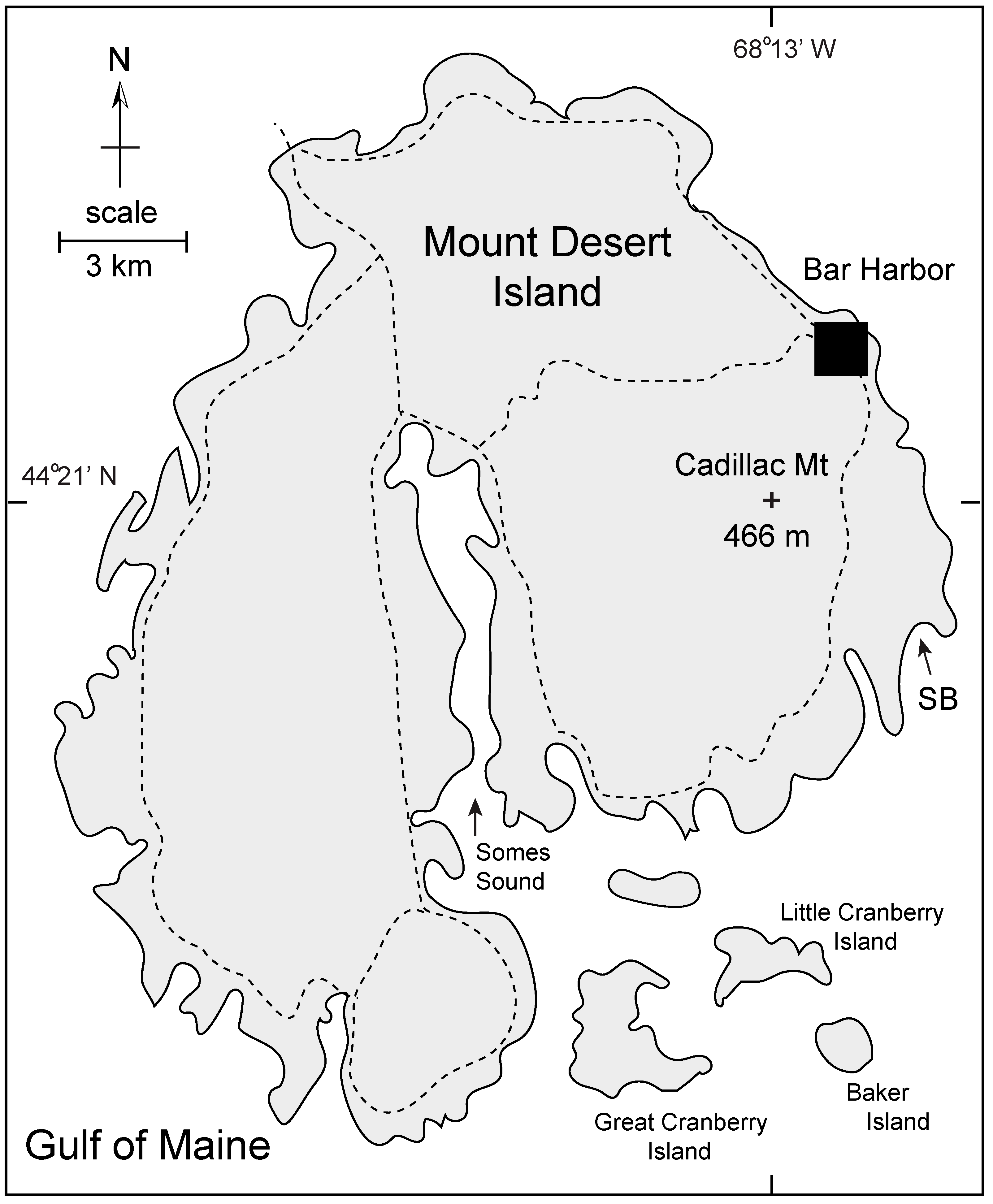
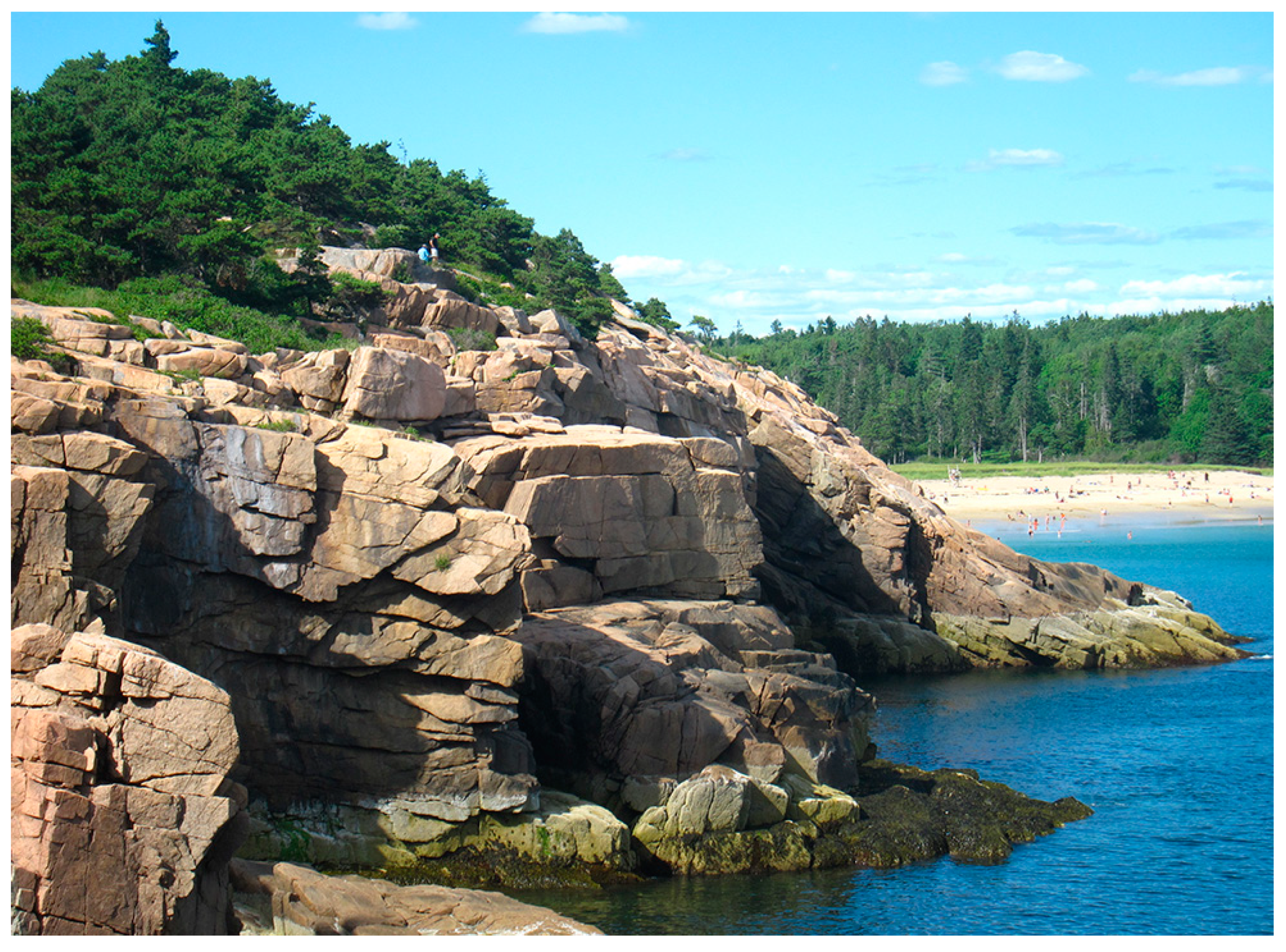
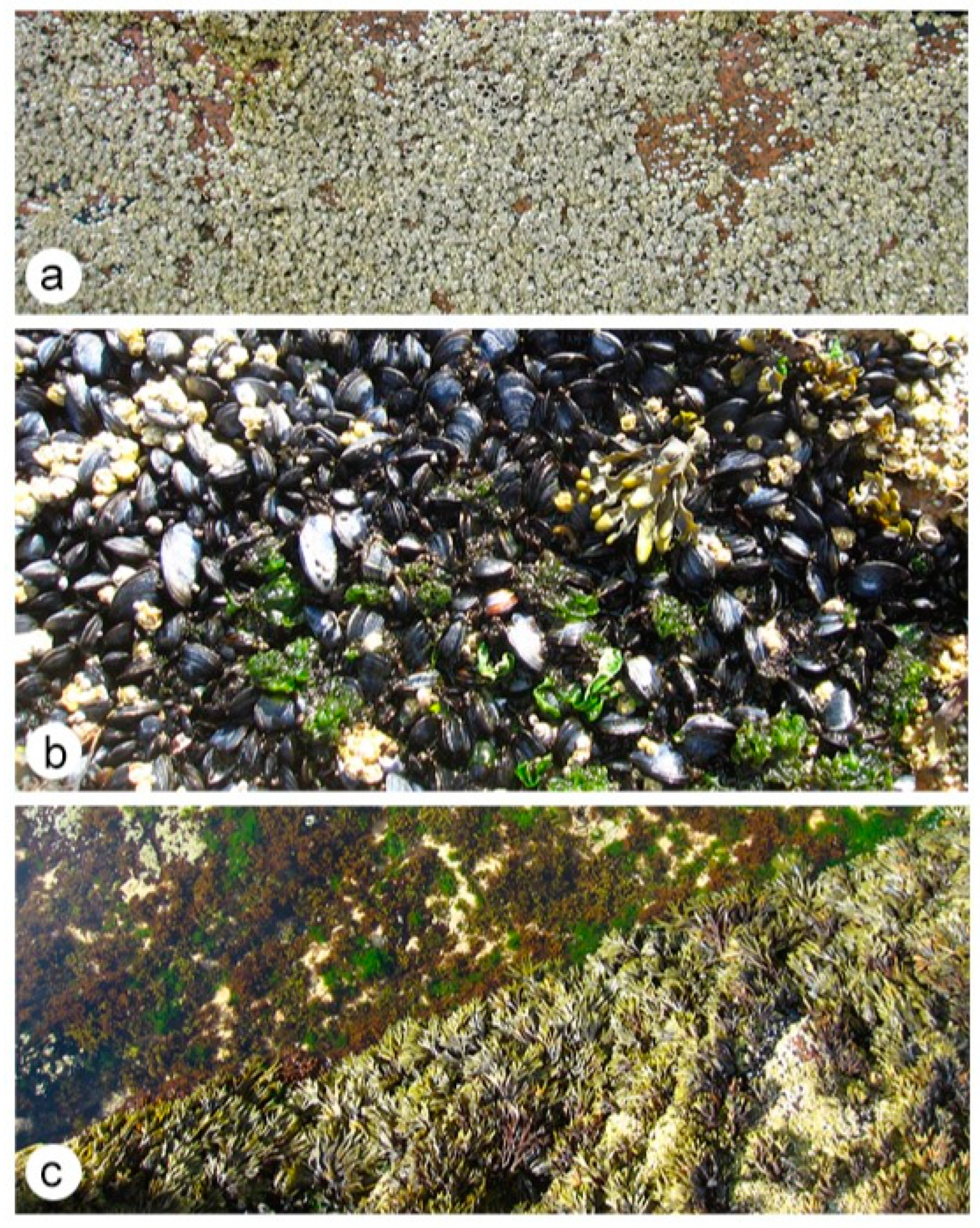
4.1.1. Mount Desert Island (Maine, USA)

With an area of 280 km2, Mount Desert Island is the largest island on the coast of Maine in the Atlantic Ocean’s Gulf of Maine (Figure 2). Granite shores are exposed almost continually around the island’s periphery. The highest elevation is on Cadillac Mountain at 466 m above sea level. French explorer Samuel de Champlain gave the island its name in 1604, observing that the granite highlands were free of vegetation and, therefore, barren. The island is home to Acadia National Park within the United States National Park system and incorporates 70% of the island’s land area. The most distinctive geographic feature on Mount Desert Island is Somes Sound (Figure 2), which is considered a fjord and the only such example of its kind in the lower forty-eight states of the USA. The narrows extend for more than 9 km to the island’s center with an average depth of 30 m. Like the more classic fjords of Norway and Alaska farther north, Somes Sound was excavated by glacial action when Maine was covered by ice during much of the Pleistocene Epoch. Sand Beach (Figure 2) is one of the few places on Mount Desert Island where it is possible to bathe in the ocean. A granite shore rises steeply to an elevation of 33 m on the west side of Sand Beach (Figure 3), where the typical tidal range varies between 2.5 and 3.6 m.
In her popular book The Edge of the Sea [3], covering the entire eastern seaboard of the USA, Rachel Carson denotes six distinct intertidal zones on the granite rocky shores of Maine. Here, the supralittoral fringe incorporates an uppermost black zone that favors lichens and tiny filaments of blue-green algae. Also, within the supralittoral fringe is the periwinkle zone dominated by the gastropod Littorina littorea, which feeds by grazing on the rock-covered film of blue-green algae. The zone in which they are most abundant is reached every two weeks or so by the spring tide. Native to rocky shores in northwestern Europe, the common periwinkle is an invasive species in New England. The mid-littoral zone on the coast of Maine is exposed to the air on a diurnal basis and includes two distinct sections densely crowded in the uppermost part by acorn barnacles belonging to the species Semibalanus balanoides and in the lower part by blue mussels belonging to the species Mytilus edulis. Both are filter feeders that strain seawater for plankton. Both are securely attached to the rocks in the case of barnacles by organic cement and in the case of the mussels by strong byssal threads (Figure 4a,b).
Both species are preyed on by the carnivorous dog whelk Nucella lapillus, which deploys a radula mouthpiece to bore holes through barnacle and mussel shells to access the tissues within using enzymes to transform those tissues into a digestible liquid. The infralittoral fringe along the rocky coast of Maine is exposed to the air every two weeks also by the spring tide, with adjacent zones dominated above by green algae commonly called rockweed, Fucus distichus, and a lower band of red algae commonly called Irish moss dominated by Chondrus crispus (Figure 4c). During extreme low tides, the upper part of the brown algae zone dominated by kelp may be briefly exposed to the air.
A checklist maintained by the Huntsman Marine Laboratory provides a comprehensive list of marine invertebrates by habitat and depth range for Passamaquoddy Bay on the border between Maine in the USA and New Brunswick in Canada [20]. Like Mount Desert Island nearby, the shoreline around Passamaquoddy Bay is dominated by rocky shores. A list of 70 marine invertebrates that occupy the intertidal zone and infratidal fringe may be identified and separated from other species that dwell exclusively in deeper, subtidal waters. Those faunal elements in possession of calcite exoskeletons have a high likelihood of fossilization. They are dominated by mollusks that include chitons, limpets, coiled gastropods, and bivalves. A single brachiopod, four bryozoa, four barnacles, and five arthropods with a semi-durable carapace also fit this category. Together, they amount to 33 taxa. Another 33 taxa include sponges, sea anemones, flatworms, polychaete worms, and sea slugs (nudibranchs) that have little or no chance for fossilization. Sea stars and brittle stars in the phylum Echinodermata might be added to this category but have a spotty record of fossilization. Hence, the overall faunal list of rocky intertidal and littoral fringe dwellers from the coast of Maine and New Brunswick is almost evenly split between taxa that have the potential for preservation as fossils and those that do not. Marine fleshy algae from the inter-tidal fringe in temperate settings include many red, green, and brown algae, none of which have a reliable record of fossilization.

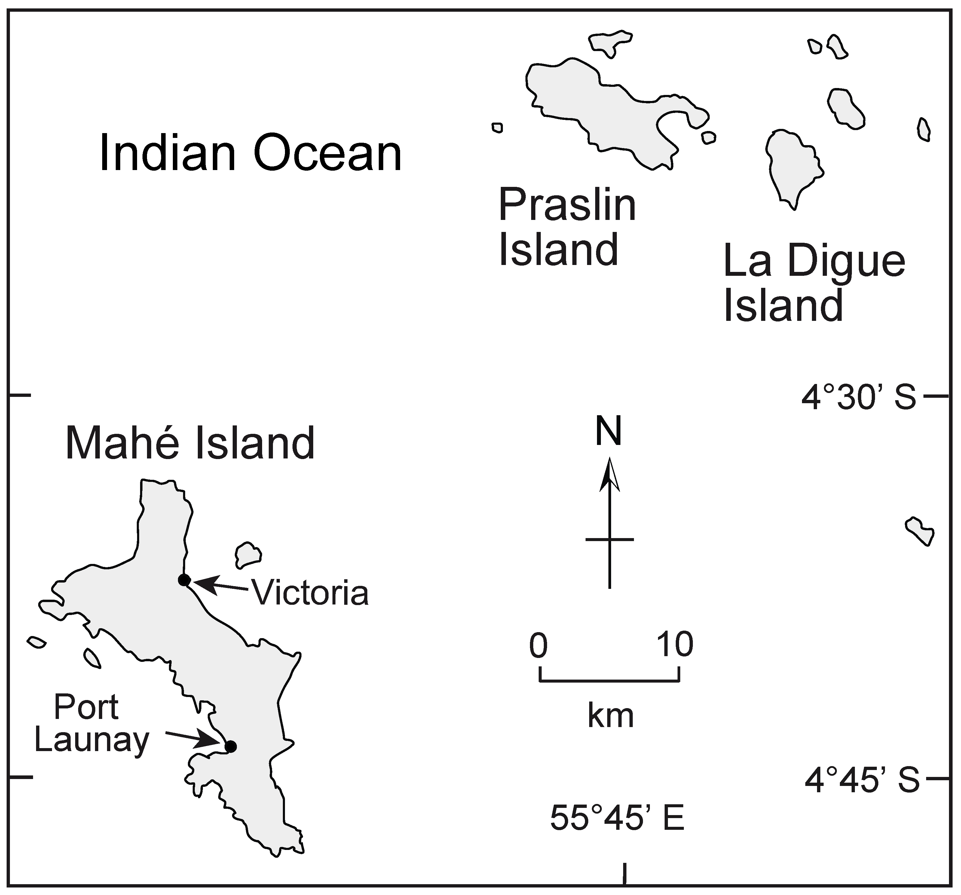
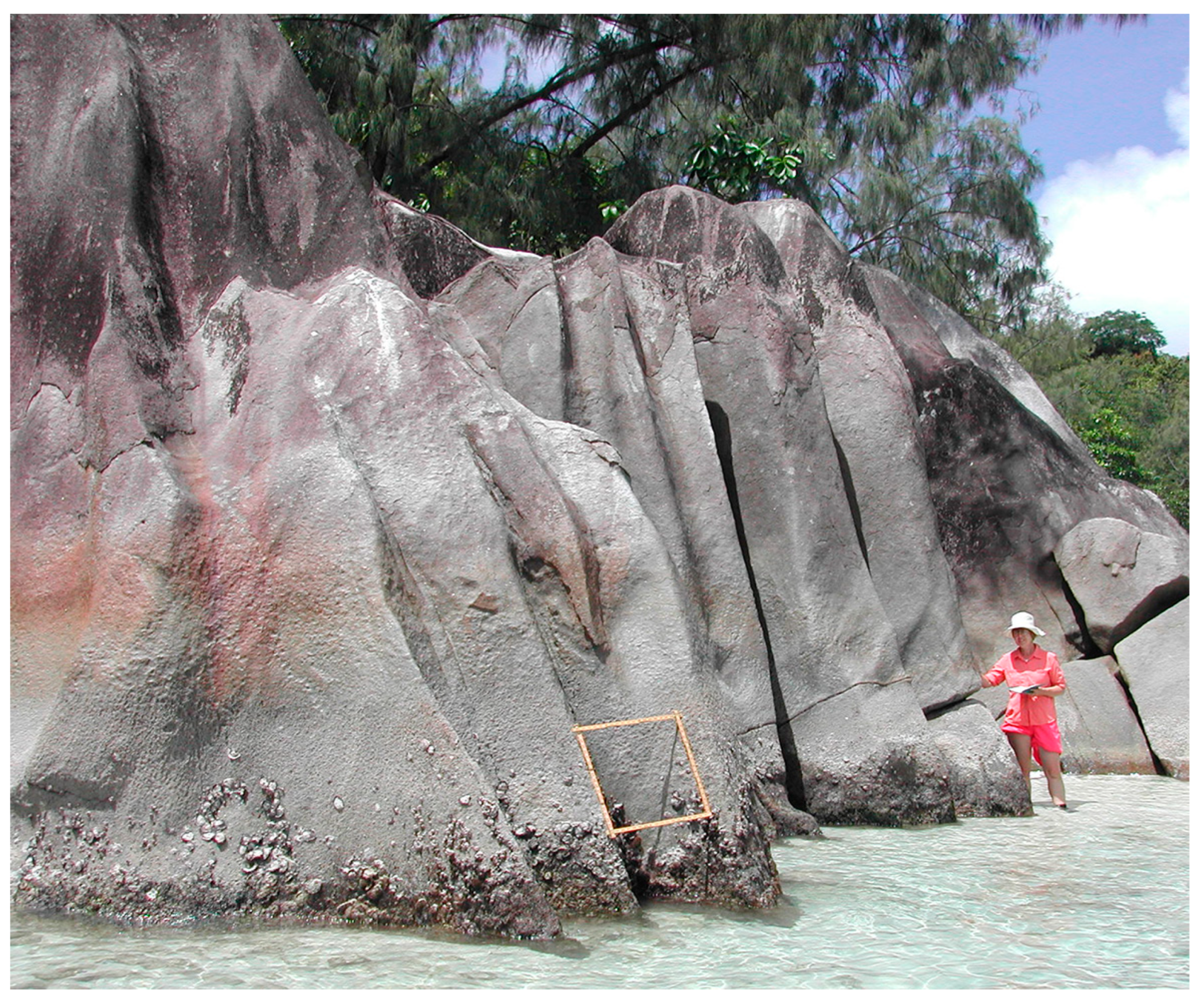
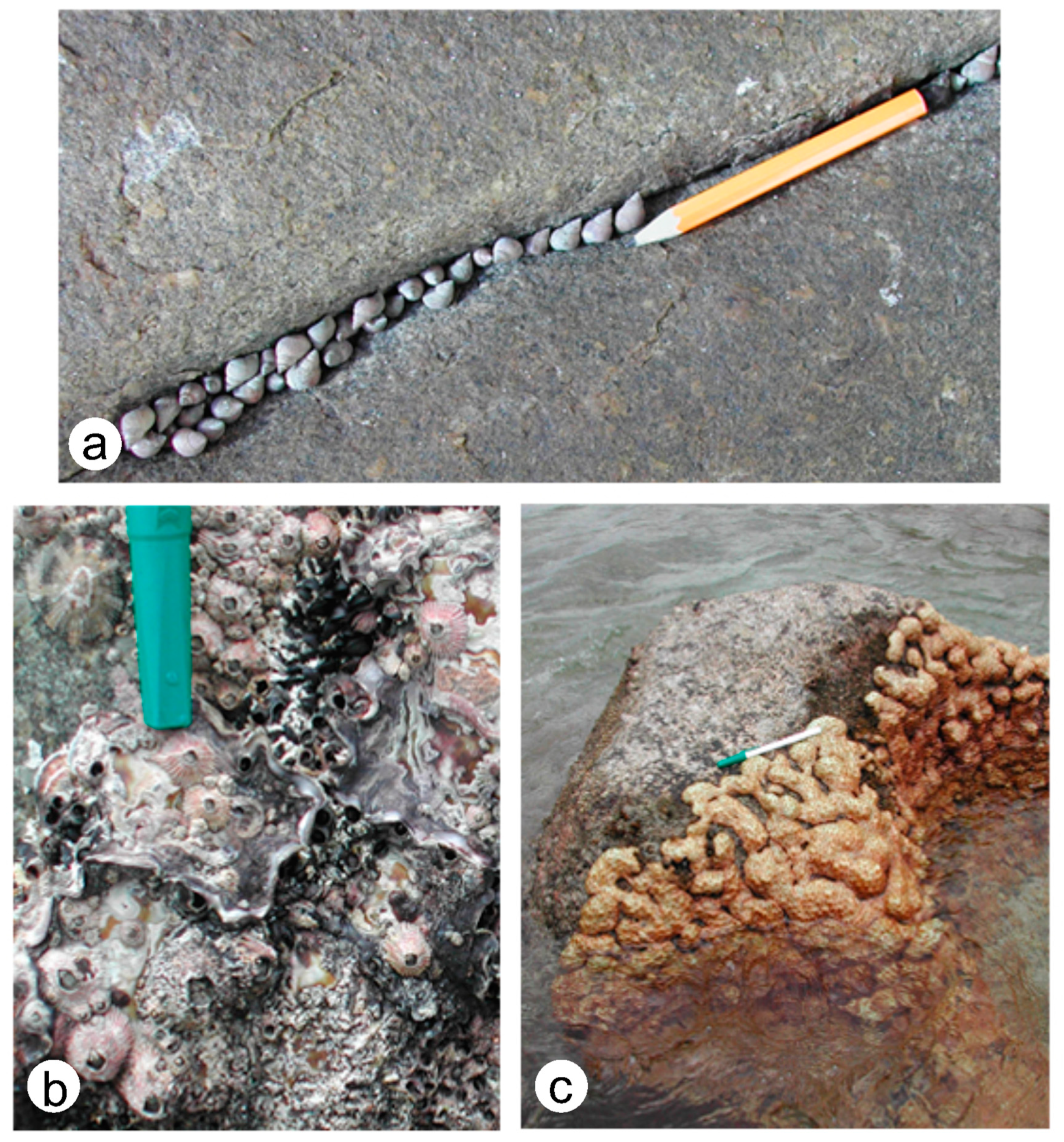
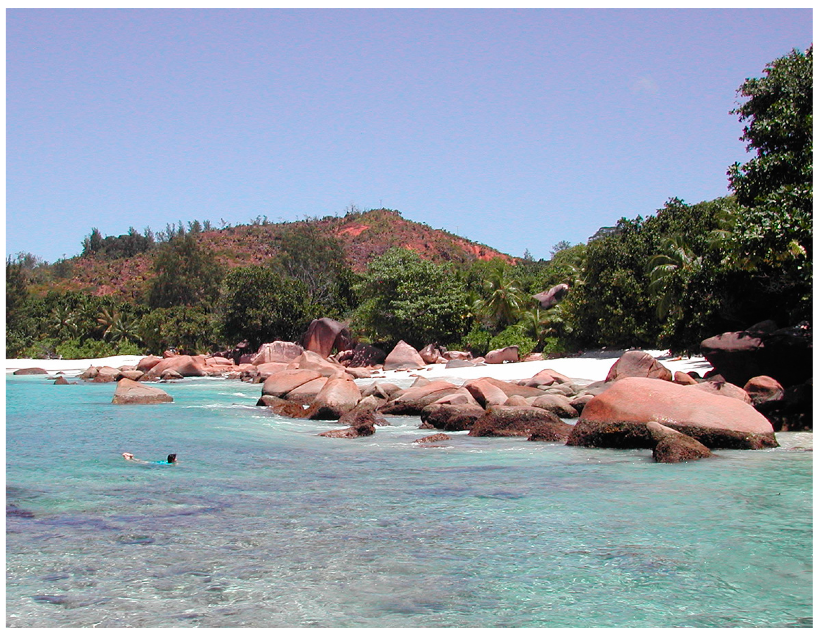
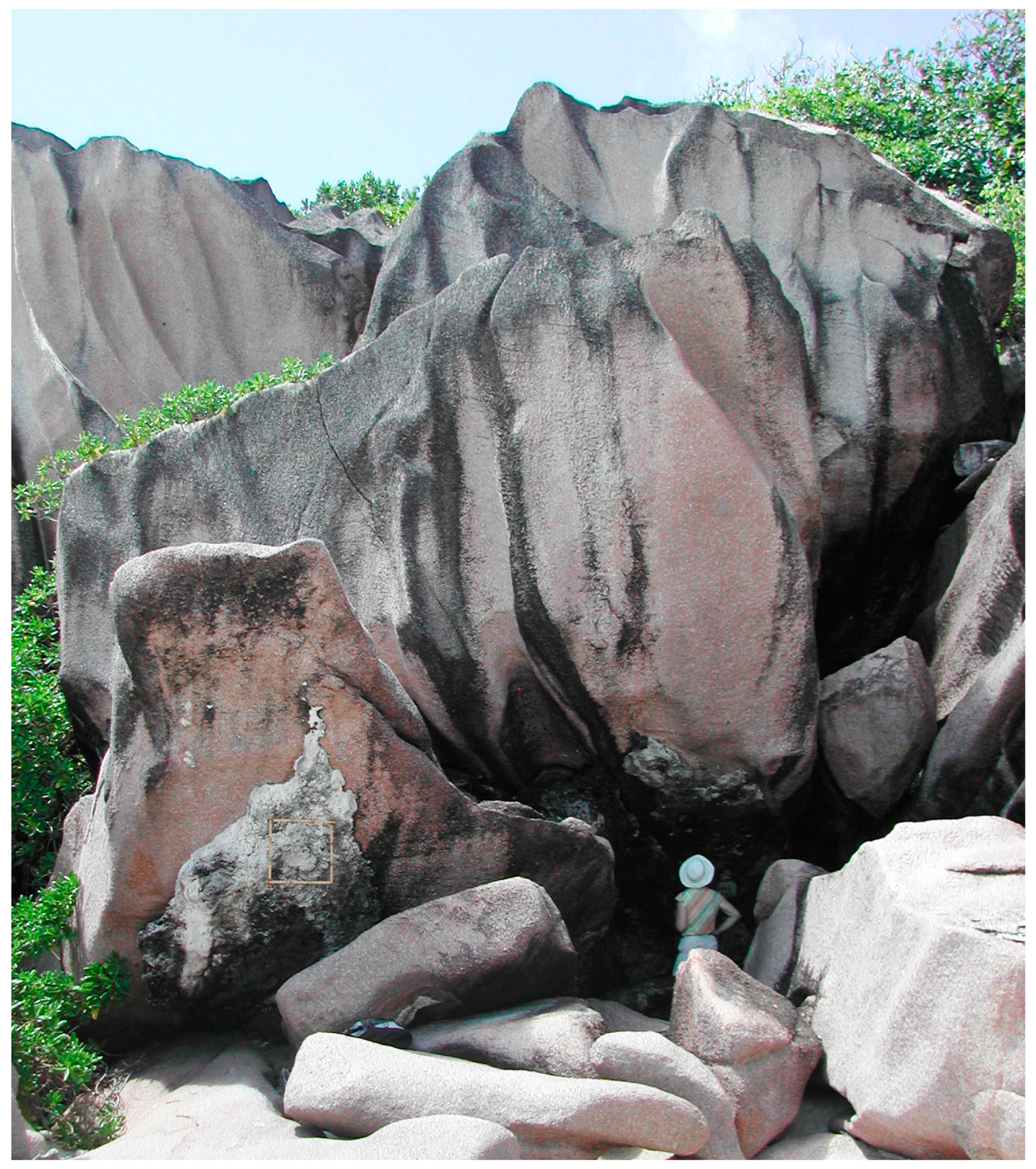
4.1.2. Mahé and Praslin Islands in the Republic of Seychelles

The Seychelles archipelago consists of 115 islands spread across a relatively shallow bank covering 1,340,000 km2 in the Indian Ocean, 1500 km off the east coast of Africa [21]. On the basis of seismic evidence, much of the bank is formed by granite, which has a thickness of 13 km draped by marine sediments [22]. Mahé and Praslin are the two largest islands among a cluster of 24 granite islands concentrated in the northern part of the bank (Figure 5). Essentially, the islands are drowned monadnocks or inselbergs that represent highland peaks of a mini-continent flooded to an average depth between 44 and 65 m with basement rocks most closely related to the nearest exposed granite on the Horn of Africa [23]. The highest peak on Mahé rises 905 m above sea level, which is twice as high as Cadillac Mountain on Mount Desert Island. In contrast, the tidal range around Mahé is only 1.2 m, which is half that experienced on Mount Desert Island. Situated below the equator, the granite islands are affected by the southeast trade winds from April to October with maximum wind speeds on the order of 50 cm/s that favor coral reefs along the windward east side of Mahé Island and south shores of Praslin Island [24].
The independent Republic of the Seychelles derives its name from the French Viscount Jean Moreau de Séchelles, Minister of Finance, during the reign of King Louis XV. The French explorer Lazare Picault landed on Mahé in 1742, and the islands remained a part of France until 1814 when they passed to British control. British influence is reflected by the name of the capital city, Victoria, named in honor of Queen Victoria in 1841. Mahé Island (Figure 5) has an area of 155 km2 with a circumference of 120 km, 66% of which is formed by granite rocky shores [21]. The Port Launay Marine National Park is located on the southwestern, leeward side of Mahé Island, where intertidal zonation typical of a more sheltered setting is developed on granite cliffs that exhibit a superb example of chemical erosion (Figure 6).
A comprehensive checklist of intertidal invertebrates for the Seychelles Islands is compiled from extensive descriptions of mollusks, arthropods, echinoderms, and corals listed in published sources [24,25] from which marine gastropods and bivalves account for 80% of the fauna represented by 74 species. Some of the principal fauna from the intertidal zone at Port Launay cover the supralittoral fringe to the infralittoral fringe within the vertical space of about one meter (Figure 7). Comparable to the habitat of the gastropod Littorina littorea on Mount Desert Island, the species Littorina undulata occupies the supralittoral fringe at Port Launay (Figure 7a). The mid-littoral zone at this location is dominated by barnacles belonging to the species Tetraclita squamosa that are densely encrusted on the inner surface of single disarticulated oyster valves represented by the species Crassostrea cucullate firmly cemented to granite (Figure 7b). The limpet species Cellana radiata is also present in this zone. No stony corals are evident in the bay at Port Launay, but granite surfaces in the infralittoral fringe are extensively colonized by the matted growth of colonies belonging to soft corals with many different species assigned to the genus Palythoa (Figure 7c).
Praslin Island (Figure 5) is the second largest island in the Seychelles, with an area of 38 km2 and a circumference of 45 km [20]. Fond Azore is the highest elevation at 367 m above sea level. The leeward side of the island occupies the north-facing shore and features extensive sand beaches, whereas the south-facing shore is in the path of the southeast trade winds and exhibits a greater concentration of granite rocky shores. The west end of the island is accessible by trails from Anse Lazio that lead to a succession of small beaches elevated behind large granite boulders that rise through the water (Figure 8).
These huge boulders are positioned far enough seaward with sufficient vertical height to capture the full spectrum of intertidal zonation in a relatively rough-water setting. In contrast to the rocks at Port Launay on Mahé, there is no evidence of oysters. The smooth and rounded tops of these boulders lack crevices that provide a safe place for grazing gastropods in the supralittoral fringe. The mid-littoral zone is compressed into a space of about a half-meter, showing a gradual change from small barnacles of the species Balanus tintinnabulum to populations of the larger barnacle Tetraclita squamosa mixed together with abundant populations of the limpet species Cellana radiata (Figure 9a). The infralittoral fringe exposed at ebb tide is occupied by a dense cover dominated by brown algae belonging to the genus Turbinaria, from which pockets of encrusting coralline red algae and patches of the soft coral Palythoa immerge (Figure 9b). Rarely, the scarlet-colored colonial coral Pocillopora damincornis may be found cemented directly to the side of a granite boulder (Figure 9c). Several other coral species are known to encrust on granite surfaces but are more commonly found growing in shallow water on the upper reef slope [24]. Brittle stars also inhabit the infralittoral fringe and are known to range upward into the mid-littoral zone during high tide.

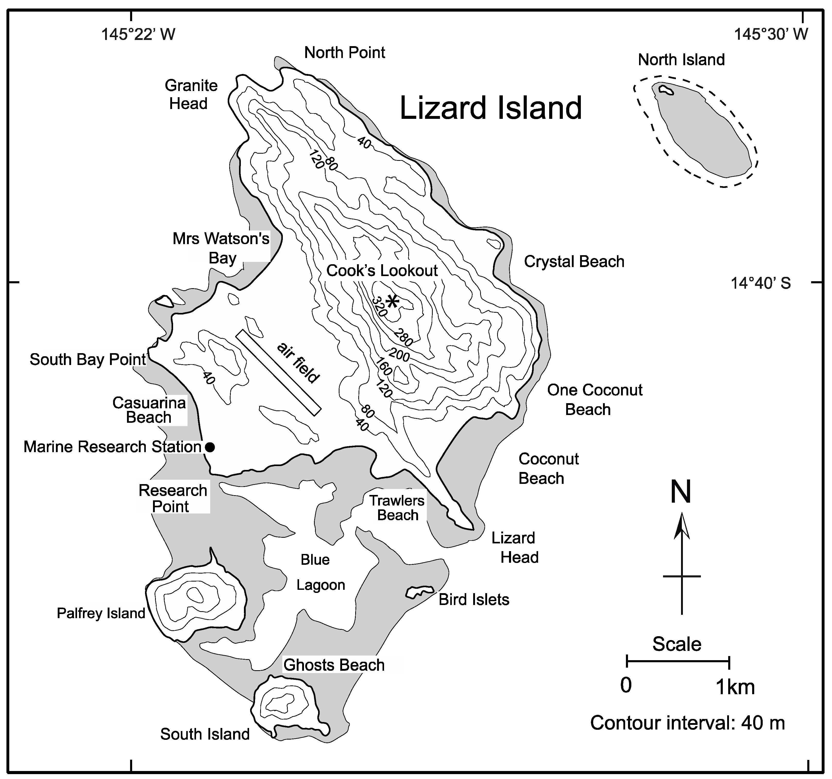
4.1.3. Lizard Island in the Great Barrier Reef off Queensland, Australia

Situated 43 km off the coast of Queensland (Figure 1 and Figure 10), Lizard Island is grouped with smaller islands called Palfrey, South, and Bird amid the Great Barrier Reef centered at a latitude 14°40′ South. In total, the islands amount to an area of 10 km2, with the highest elevation on the main island rising to 320 m above mean sea level. The peak is commemorated as Cook’s Lookout in honor of the visit by Captain James Cook in command of the HMS Endeavor in 1770. It was Cook who bestowed the name Lizard Island in reference to a population of the large Yellow-spotted Monitor (Varanus panoptes). Aboriginal people from the Australian Dingaal tribe have a long history of foraging on the island, which, according to legend, was once attached to the mainland as a sky island. Lizard Island is home to the Marine Research Station administered by the Australia Museum in Sydney and the sponsor of major research in marine biology.
The maximum tidal range for Lizard Island is 2.70 m, as recorded against the granite shores that encircle the Blue Lagoon on the south side [26]. During the Austral winter months from June to August, the primary hydrologic influence derives from the prevailing SE trade winds. A July wind speed of 45.5 km/h is characteristic from the southeast, which influences tidal flushing into the lagoon at the entrance between the Lizard Head and the Bird islets (Figure 10). During the peak Austral summer months from December through February, monsoonal winds half as strong typically impact the island from the northwest. Lizard Island is known for its six named beaches with coarse quartz sand derived from the subtropical disintegration of granite. Collectively, the beaches around Lizard Island account for about 35% of the shoreline. The rest is dominated by granite sea cliffs that rise most abruptly to the highlands on the east side of the island.
A checklist with 34 species for Lizard Island is dominated by marine gastropods and bivalves but also includes barnacles and some stony corals as compiled based on references in the research station’s library bolstered by a photo-based guidebook [27]. The supralittoral fringe with a black zone similar to Mount Desert Island, including the gastropod Littoraria undulata, appears on granite rocks in a leeward setting on Mrs. Watson’s Bay (Figure 10). Otherwise, observations on the island’s intertidal fauna are best informed from the low rocky shores and large boulders lining Trawler’s Beach on the south side of the island (Figure 10). These lack a well-defined supralittoral fringe, as described (above) from Mahé Island in the Seychelles. The mid-littoral zone on this stretch of coastline is occupied by three distinct bands of mollusks. The uppermost is dominated by the star limpet Patelloida saccarina. On average, eight to ten spur-shaped limpets are present within a 10-cm-by-10-cm space (Figure 11a), which also features empty depressions in the granite where the animal maintained a home base. The concept of a homing instinct is discussed by Rachel Carson [3], who states that Aristotle was the first to report that limpets go out to feed from a fixed station during high tide and return to the same spot when the tide recedes. Abandoned spots worn into the granite are about one centimeter in diameter. An intermediate band is occupied by the comb oyster, Lopha cristagalli. It is distinctly purple in color with a deeply crenulated commissure where the valves meet (Figure 11b). On average, 250 individuals may be counted in a sample grid covering a quarter-meter square. The ribbed gastropod, Nerita costata, overlaps with the upper reaches of the oyster band and is distinguished by its turban-shaped shell scored by strong ribs. Not as abundant as the oyster but unfailingly found to occupy a band directly below is another bivalve called the jewel box, Chama limbula (Figure 11c). Stony corals such as Goniastrea palauensis are rarely exposed attached to granite during the Spring tide, but soft mat corals in the genus Palythoa cover extensive surfaces (Figure 11d).

4.2. Clues to Potential Fossilization from Beach Deposits

The mineral content of granite may reach 50% in silica (SiO2). Adjoining beaches between granite headlands become enriched with quartz sand as a consequence of the physical weathering and slow decomposition of a granite rocky shore. Quartz itself is resistant to erosion, which means that the size of sand grains on any given beach depends on the original size of that mineral at crystallization in the parent granite. Such beach sand is likely to include eroded granite pebbles as well as the detritus of eroded exoskeletons from the marine invertebrates and certain calcareous algae that thrive on rocky shores. In tropical settings worldwide, between 35° N and S of the equator where dissolved calcium-carbonate (CaCO3) is present in seawater, deposits may be lithified as beachrock. Such a process of beach lithification that has been ongoing during recent and contemporary times is evidenced by the preservation of shell casings from World War II battles in certain South Pacific islands as well as coke and rum bottles in Caribbean islands [28]. The contents of beachrock also may reflect organic materials carried landward from subtidal environments during major storms.

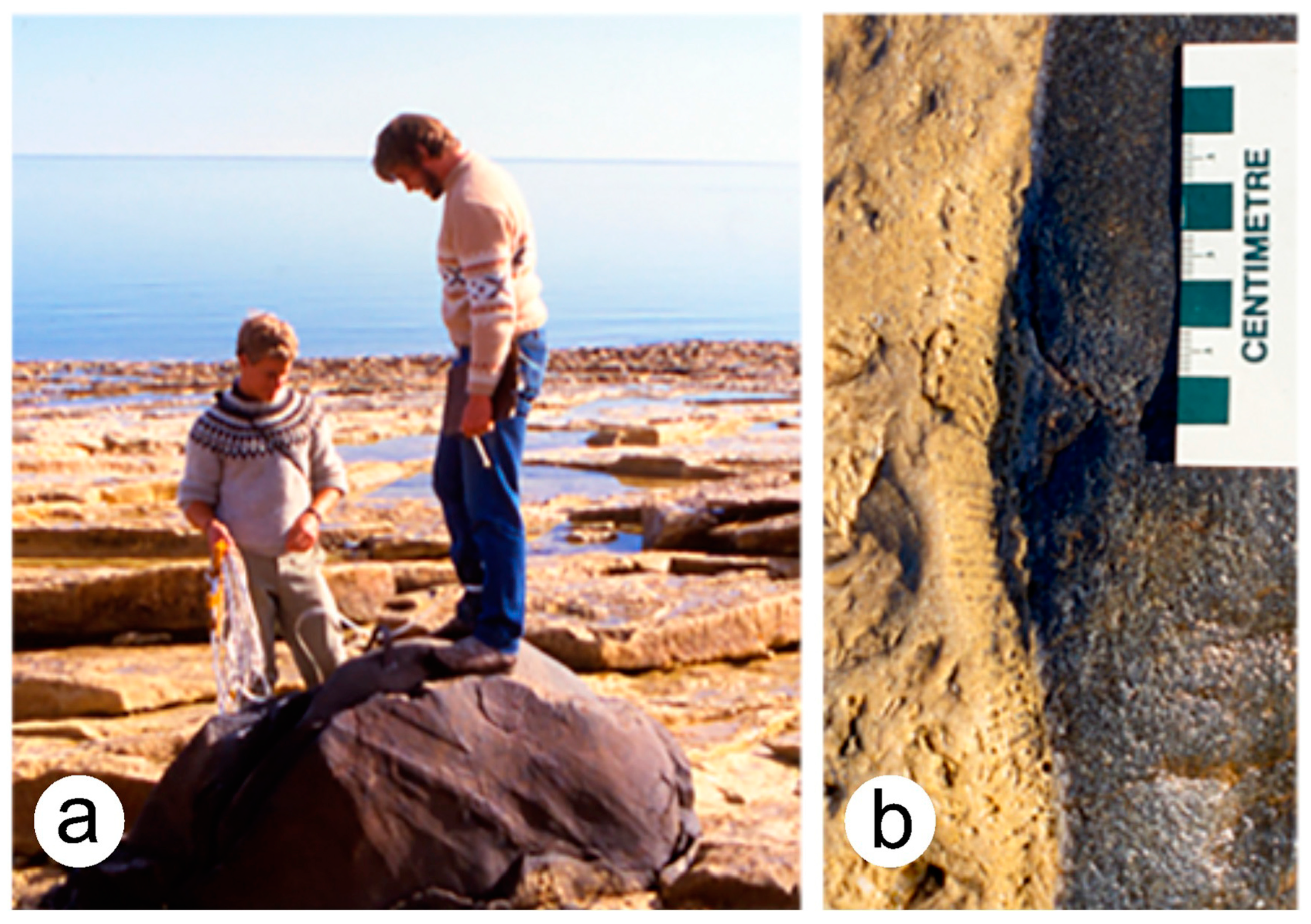
4.2.1. Analysis of Sand Beach on Mount Desert Island, Maine

The location of Mount Desert Island 44° north of the equator (Figure 1) is nine degrees of latitude remote from the normal production of beachrock. However, Sand Beach on Mount Desert Island (Figure 3) contains an unusually high component of calcareous materials with as much as 65% by volume derived directly from the detritus of shore-dwelling barnacles and mussels as well as echinoids and coralline red algae more characteristic of the sublittoral fringe [29,30]. Silica sand is present, but the occurrence of such a major component from a biological source is counter-intuitive because cold seawater in the Gulf of Maine drives the dissolution of calcium carbonate (CaCO3). During the lifetime of a blue mussel, for example, the animal’s shell is protected from dissolution by a thin outer layer of the periostracum composed of proteins and lipids impervious to leaching. Once the host animal expires, the periostracum rapidly disintegrates, and the underlying shell layers will completely dissolve, given sufficient exposure to cold seawater. An exceptionally high rate of sediment supply of shelly detritus at Sand Beach on Mount Desert Island and similar small beaches on Great Cranberry Island is due to the frequency of coastal storms that resupply those beaches on a regular basis. What is most favorable, from a paleontological perspective, is the potential preservation of a rocky-shore biota attached to a rock substrate in its original growth position. However, the burial and subsequent lithification of beach sand in high latitudes provides a reasonable alternative as a death assemblage (thanatocenosis) for the purpose of recovering census information from a past habitation.

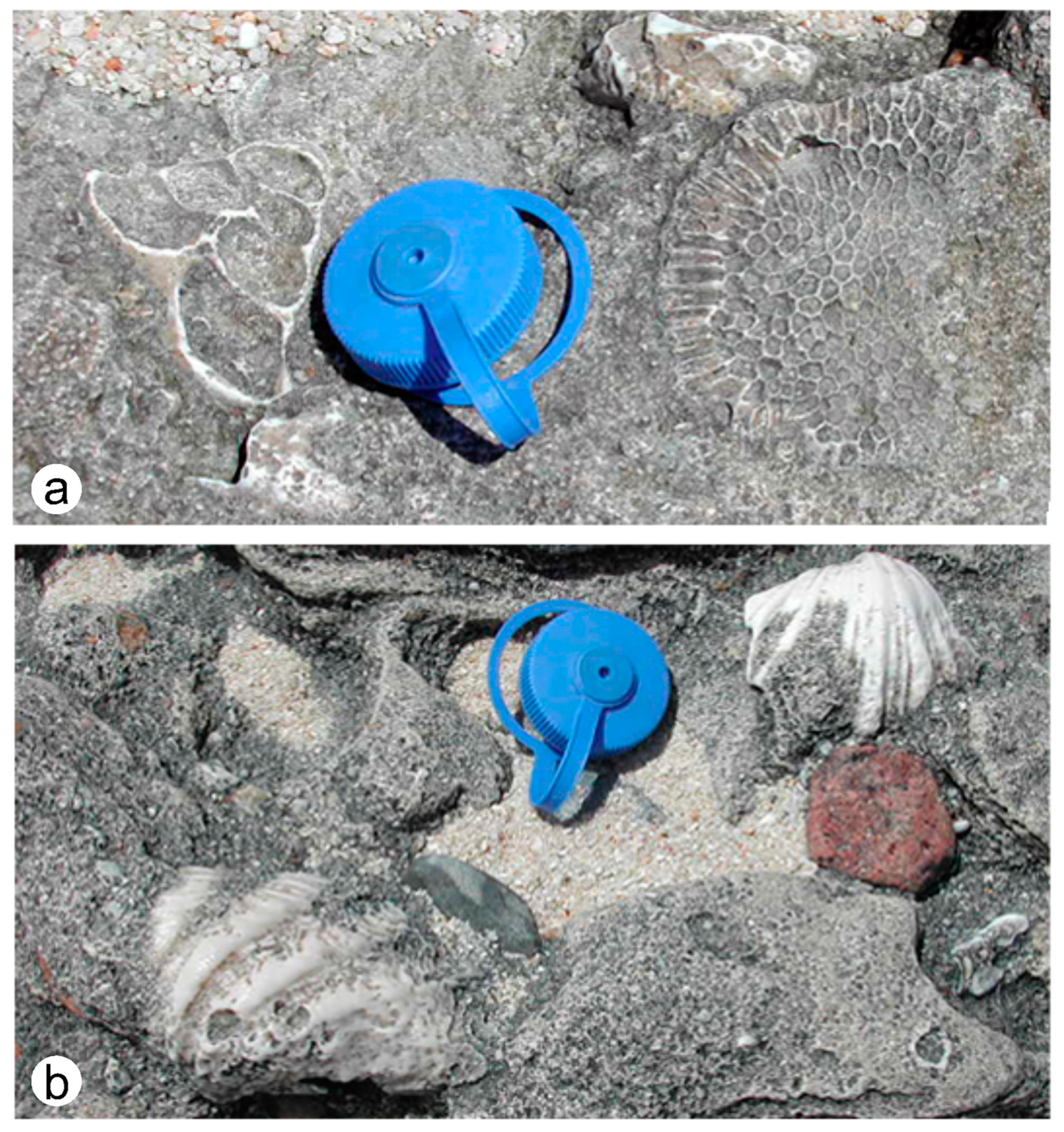
4.2.2. Beachrock on Palfrey Island in a Subtropical Setting

Among the smaller islands clustered around Lizard Island, Palfrey Island (Figure 10) is notable for extensive beachrock deposited among the granite boulders along the south shore over a distance of 0.25 km. No systematic survey is available regarding the faunal composition and relative frequency of extant marine invertebrates entombed in the beachrock. However, general relationships are apparent to the casual visitor. Common elements represented in the Palfrey Island beachrock include large mollusk shells and various stony corals. One of the most distinctive gastropods readily identified by its conical profile in cross-section is Trochus lineatas, having a basal diameter of 10 cm (Figure 12a). It may occur in close proximity to stony corals in the genus Favites (Figure 12a) as well as Lobophyllia. The most abundant mollusk is represented by disarticulated valves of the large bivalve in the genus Tridacna (Figure 12b). Pieces of Tridacna shells preserved within the beachrock are relatively small, 15 cm in maximum width, but live individuals from the adjacent reef may possess shells more than a meter in width. Although the Palfrey Island beachrock incorporates granite pebbles, the larger faunal elements are characteristic of a reef habitat and not especially a rocky-shore habitat.

4.3. Review of Pre-Historic Rocky-Shore Biotas from the Fossil Record

Preferable to the worn and degraded biological elements preserved in beachrock, a superior method for the survey of rocky-shore biotas in the pre-historic fossil record relies on the availability of materials in original growth position preserved either encrusted against or in close proximity to the surface of a geological unconformity. Under the circumstances ideal for detailed analysis, the unconformity should be overlain by marine sedimentary rocks, with the underlying unconformity exposed on a scale that exceeds more than a few meters in lateral extent. It is a false assumption that all rocky shores exist in an environment that is entirely erosional in character to the detriment of fossils in anything like their original life conditions (biocenosis from the German biozönosen) [8,11]. In fact, burial of an unconformity surface will occur under conditions where a sudden storm event transfers a blanket of sediments shoreward or the ejecta from a volcano engulfs a particular coastline. The same requirement for rapid burial of any particular organism with hard parts as a fossil applies equally as well to the fossilization of a rocky shore with all those inhabitants in possession of sturdy exoskeletons. Under some circumstances, the rocky shores that encircle a small island may be fossilized intact [13]. Although there are exceptions to the rules of fossilization, the principal drawback is that animals with only soft body parts or fleshy algae, such as green and brown algae, are rarely preserved.

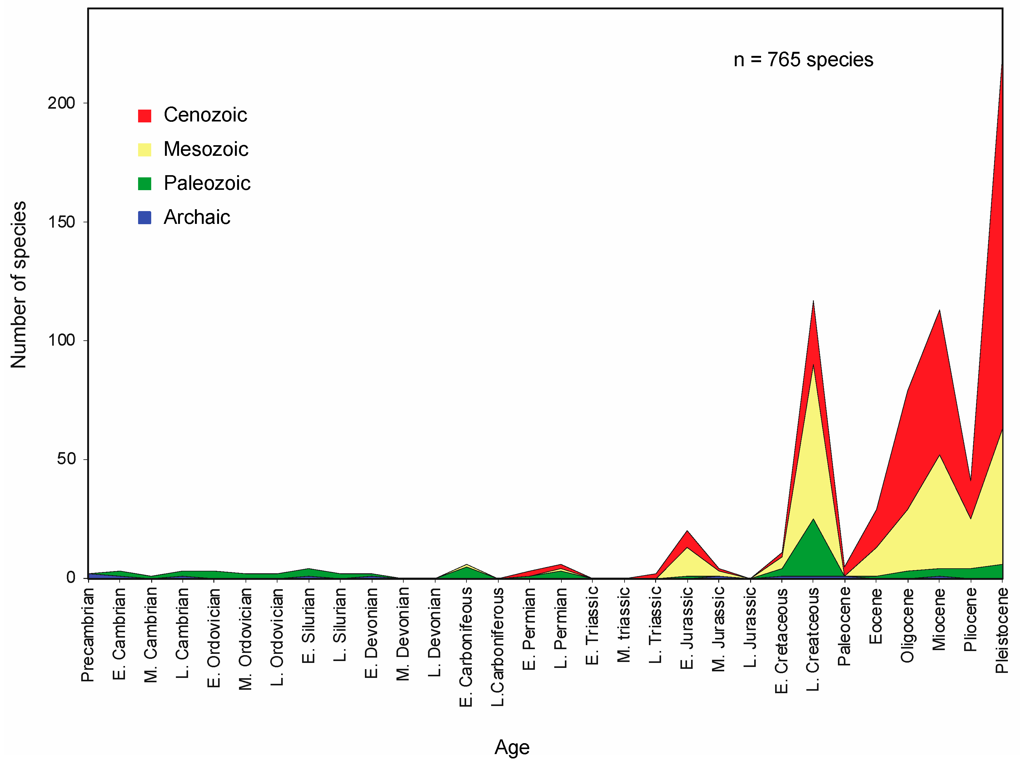
4.3.1. Analysis of Phanerozoic Rocky Shore Publications

A bibliography of published studies on prehistoric rocky shores was issued in 2012 [10]. It lists 151 scientific articles that describe geological unconformities and related fossil-bearing deposits diagnostic of intertidal biotas. Since 2012, the scholarly community has continued to release additional work on this topic, but the 2012 bibliography is notable for specific trends that have remained current, even with a modest increase in studies originating from additional parts of the world or as follow-up studies at the same locality. Such trends are readily apparent from a histogram showing the relative distribution of study localities arrayed according to the six time periods across the Phanerozoic Eon (Figure 13). In most cases, the 163 study localities covered in the 2012 bibliography provide detailed information that attributes a particular rocky-shore biota to a designated epoch. In theory, the fossil biotas represent a given instant in geological time during which marine invertebrates and some algae were catastrophically buried alive on a rocky shore and preserved intact in numbers and proportions faithful to their life habitat. The site may survive as a lasting marker once the former shore is uplifted and exposed.
A notable major trend suggests that fewer well-described rocky-shore biotas derive from studies of fossils representing Paleozoic intervals of geologic time, whereas the most recent Cenozoic intervals account for almost a third of the whole. This is the case despite the fact that the Cenozoic represents only 12% of the total elapsed Phanerozoic time, whereas the Paleozoic represents more than 50% of the total. A likely explanation for the overall trend is that the Cenozoic rock record has had less time to disappear due to mass erosion and normal patterns of recycling related to plate tectonics. Another significant detail is that examples of rocky-shore biotas from the Triassic Period have yet to be recognized and described. This gap in Mesozoic data represents a major hole in our understanding of ecosystem development on rocky shores that is yet to be addressed. The lack of possible data from the Triassic Period could be related to the style of plate tectonics in operation during a time when a single land mass called Pangaea and a single great ocean called Panthalassa existed (see Discussion). More generally, however, time may have been required for the gradual evolution of the most sophisticated characteristics, allowing marine invertebrates and algae to colonize the available living space on intertidal rocky shores.
Another aspect from the 2012 data base [10] relates to the general geographic distribution of places where the research community carried out its studies. These data are presented in a pie diagram largely divided into slices by continents (Figure 14).
Europe (including the British Isles and Scandinavia), together with North America, account for nearly 70% of all research conducted on prehistoric rocky-shore biotas worldwide up to 2012. Australia and New Zealand combined account for a distant third place with 9% of the accessed studies. The substantially larger area of Asia as a land mass compared to any other accounts for only 7% of studies. Oceanic islands that span seas as distant from one another as the Caribbean and Mediterranean account for 7%. Lastly, the vast holdings of Africa and South America combined account for another 7% of the source areas for this kind of research. The clearest inference from these data is that researchers from lands outside of Europe and English-speaking regions, including the USA, Canada, Australia, and New Zealand, have been less aware of or perhaps less enthusiastic about contributing to this particular aspect of paleoecology and shared geoheritage. The overall paucity of data from Asia, Africa, and South America clearly represents a significant void in our understanding of the rocky shore ecosystem and how it evolved with time.

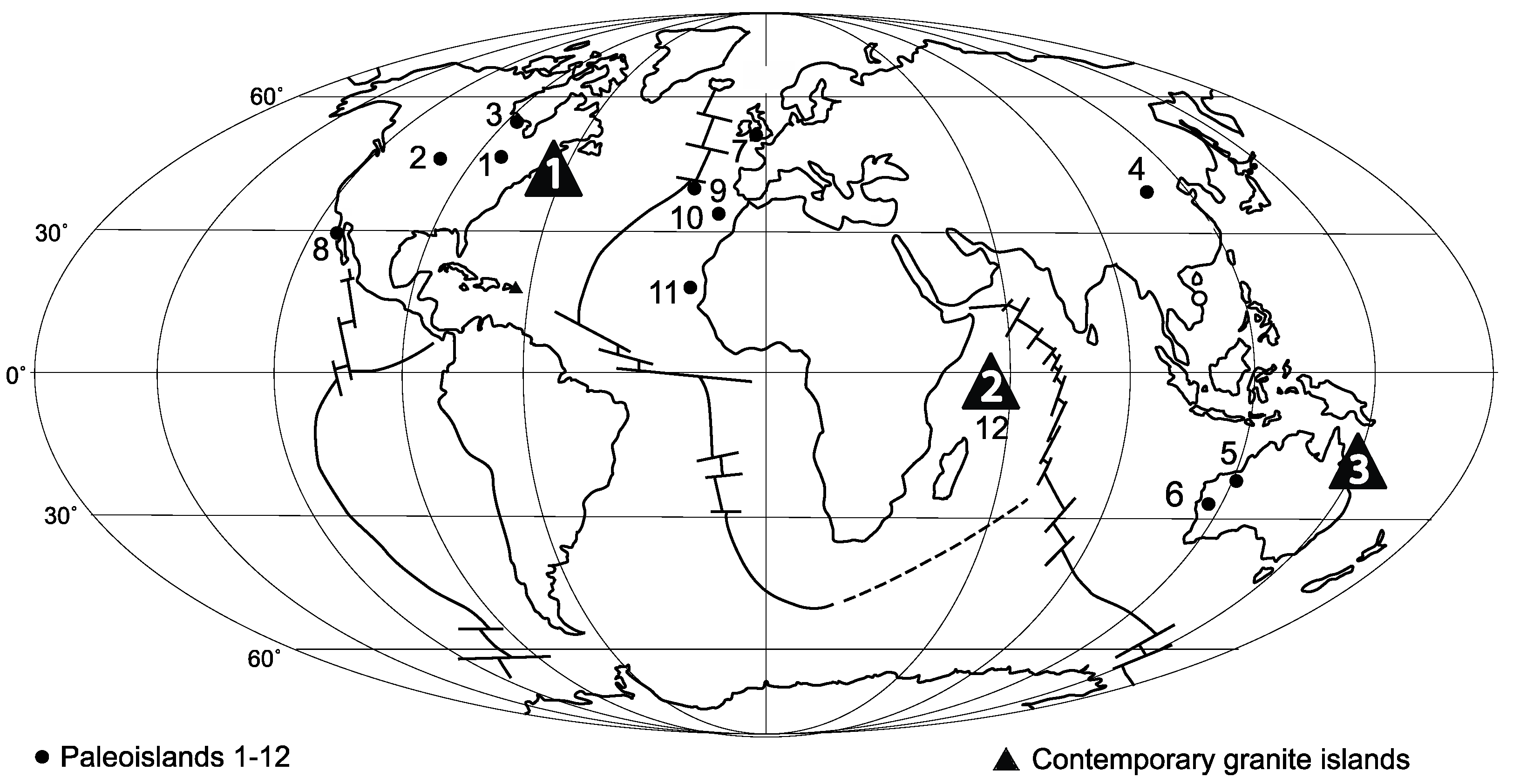
4.3.2. Review of Phanerozoic Rocky Shore Studies on Paleoislands

Although fresh discoveries have yet to be described from the greater part of the earth’s surface outside Europe and North America, extraordinary examples of entire archipelagos that range in age from the late Cambrian 485 million years ago to the last inter-glacial epoch only 125,000 years ago are well known [13,17]. A dozen such island clusters are identified at their present-day locations around the world (Figure 1). They are numbered in order of age from the oldest (Cambrian) to the youngest (Pleistocene). In each example, the earth’s continents were positioned in very different places than today, and the global sea level was higher than at present. This accounts for why paleoislands in North America, China, and Australia appear today as sky islands far from the nearest ocean.
The Cambrian Baraboo archipelago in south-central Wisconsin (Figure 1, locality 1) forms a cluster of about 30 individual paleoislands spread over an area of 1200 km2 with an oval-shaped distribution around the town of Baraboo [17,31,32]. Formed by 1.7-billion-year-old Proterozoic quartzite surrounded by late Cambrian conglomerate belonging to the 485-million-year-old Tunnel City Group, the largest of the islands covers 50 km2. More than half of the islands are much smaller at 4 km2 in area. Although Cambrian marine sandstone deposited in between the islands is rich in fossils that include trilobites and even trace fossils representing jellyfish, there are no fossils preserved among the quartzite clasts in the eroded Cambrian conglomerate surrounding the various islands. Thus, there is no evidence of inter-tidal fauna at this location. The islands, themselves, would have been barren of land plants, the earliest fossil evidence for which would not appear for another 40 million years as moss and liverworts. Also organized around Proterozoic quartzite monoliths, Cambrian paleoislands in the Black Hills of South Dakota (Figure 1, locality 2) feature conglomerates composed of eroded quartzite clasts, some of which show evidence of small borings made by an unknown organism [33]. Additional studies of this kind are needed, but it appears that inter-tidal life during the Cambrian Period was absent or extremely limited.
The Ordovician Jens Munk archipelago in Canada’s northern Manitoba (Figure 1, locality 3) forms a group of ten individual paleoislands spread over an area of 300 km2 along the shores of Hudson Bay [17,34,35]. Like the older Cambrian islands in Wisconsin and South Dakota, the Ordovician islands are formed around a core of Proterozoic quartzite. Only 1.5 km2 in size, one of the smaller paleoislands is flanked by a thick conglomerate deposit composed of eroded quartzite clasts, some of which are enormous. The conglomerate outcrop can be traced for 350 m along the shores of Hudson Bay but is fully exposed only during low tide. A line of individual boulders roughly 2 m in diameter forms a distinct boundary between the Ordovician shoreface and outer zones represented by layered dolostone dipping northward into the bay (Figure 15a). The quartzite boulders are aligned with the paleoshore and feature tabulate corals encrusted directly against the the rock surface (Figure 15b). Two genera of tabulate corals are known from this habitat, Favosites and Ellisites. In the seaward direction, large colonies of free-standing tabulate corals occur belonging to the genera Palaeophyullum, Calapoecia, and Catenipora that measure up to 46 cm in diameter. The Jens Munk archipelago is notable both for its rocky shore corals and for the preservation of offshore fossil zones that include the largest known trilobite, Isotelus rex.
Bater Island is a late Silurian paleoisland formed around a core of older Ordovician diorite on the grasslands of China’s Inner Mongolia (Figure 1, locality 4). Measuring 610 m by 200 m, this small oval-shaped paleoisland is distinctive for its enclosing rim of sedimentary rocks that feature eroded diorite boulders in conglomerate on one side and silty limestone on the opposite side [17,36]. Large stromatoporoid colonies attributed to the genus Plexodictyon occur as armored sponges attached to the diorite in a leeward habitat interpreted on the basis of the prevailing silty limestone (Figure 16). Smaller stromatoporoids identified as Clathrodicyon gotlandense and Actinostromella slitensis) occur in a habitat interpreted as windward on the basis of the related diorite conglomerate. In addition, a total of seven coral species belonging to six genera are preserved as rocky shore dwellers around the island’s circumference [37]. After a passage of some 25 million years post-dating the marine fauna around the Ordovician Jens Munk archipelago of Canada, it is notable that the Silurian coral fauna from Bater Island records a significant expansion in shore-dwelling corals as well as the first known occurrence of shore-dwelling stromatoporids.
The Mowanbini archipelago in Western Australia (Figure 1, locality 5) consists of two large paleoislands and some 20 satellite paleoislands formed by interbedded Paleoproterozoic quartzite and phyllite rocks in the Oscar Range surrounded by late Devonian limestone spread across an area of 175 km2 [17,38]. The basement rocks from the Paleoproterozoic precede the surrounding Devonian strata by roughly two billion years. Exposure of the tilted quartzite and phyllite layers in Devonian time resulted in an island landscape rising 90 m above the shores of what was a set of distinctly outer and inner lagoons floored by the Pillara Limestone. A major barrier reef developed on the open seaward side of the islands (Figure 17), separated by a narrow lagoon. A larger inner lagoon separates the islands from the mainland of the granitic Kimberley Block. Tabulate corals belonging to the genus Disphyllum contributed to the makeup of an extensive reef structure, but the main component of reef builders was supplied by a range of species belonging to the armored sponges, or stromatoporoids.
During the 45 million years following the late Silurian development of China’s Bater Island, the stromatoporoids went through a major Devonian diversification that introduced a range of new organisms to the lagoons around the islands off the Kimberley Block of Western Australia. Intricate details of off-shore zonation are preserved in the Pilara Limestone around smaller satellite islands within the inner lagoon on the present-day north side of the Oscar Range [17,39]. Exquisite preservation in a three-dimensional layout, which includes reefs, outer lagoons, paleoislands, and inner lagoons, leaves little to the imagination in exploring all parts of this former coastal region from about 375 million years in the past.
Occurring also in Western Australia, the usual Permian tower karst dissolved from the Callytharra Formation to expose an extensive network of intersecting galleries, much like city blocks, and was subsequently buried by Permian sandstone from the Moogooloo Formation along the Kennedy Range in the Gascoyne River district (Figure 1, locality 6). Each block is the size of a two-to-three-story, rectangular apartment building. When flooded during the deposition of the sandstone, each block would have been the equivalent of a small islet. Evidence of organic borings discovered on the top of a block near Congo Creek may have been formed anytime before the covering sandstone was deposited or long after it was stripped away [17]. The Permian topography is much like the present-day tower karst flooded by Ha Long Bay in northern Vietnam, also formed by Permian Limestone.
As in the case of the Permian tower karst at Gascoyne Junction, another example of an unconformity formed by two bodies of adjoining sedimentary rock occurs along the Bristol Channel in southern Wales (Figure 1, locality 7), where Carboniferous limestone is directly followed by Jurassic limestone representing a major time gap of about 50 million years. The area has a long history of geological investigation, dating from work published in 1846 [40] by the director of the British Geological Survey, Henry De la Beche (1796–1855). His study illustrates the unconformity at Dunraven Bay (Figure 18) and describes examples of trace fossils bored into the Carboniferous limestone by Jurassic lithophagid bivalves and likely polycheates attributed to the trace-fossil genus Trypanites [41]. The Carboniferous limestone is also encrusted by various Jurassic bivalves like the oyster Liostrea hisingeri and colonial coral Allocoeniopisis gibbose, as well as the mobile limpet Patella suttonenis [17,41]. The same fauna is found in the overlying conglomerate belonging to the Sutton Stone, exposed only a short distance to the west, which is interpreted as a major storm deposit. The conglomerate fits with a catastrophic event that buried the unconformity surface and preserved the encrusting fauna in place on the rocky coast of a paleoisland in what is called the Jurassic Saint David archipelago.
Towards the close of the Cretaceous Period about 70 million years ago, a group of small islands and headlands formed by andesite lava flows were eroded along the present-day shores of the Pacific Ocean on Mexico’s Baja California peninsula (Figure 1, locality 8). The uplifted strip of land north and south of Eréndira village covers an area of approximately 75 km2 and features two distinct paleoislands, two prominent headlands, and a large sea stack formed by andesite partially enclosed by limestone belonging to the El Rosario Formation [17,42]. Cretaceous limestone in direct contact with the andesite unconformity surface on three sides of a paleoisland exhibits evidence of windward and leeward variations distinguished by the dominance of encrusting rudist bivalves in a windward, rough-water setting as opposed to encrusting oysters in a leeward, calm-water setting [17,43]. Small rhodoliths with a rind up to 0.5 cm in thickness formed by coralline red algae around andesite pebbles also characterize a distinct zone on the windward side of the paleoisland. Where pebbles are entirely coated on all sides with a uniform thickness by such algae, it signifies that the water turbulence was nearly constant due to wave activity. A greater faunal diversity occurred on the more sheltered rocky shore, with as many as 16 species of marine invertebrates.
The Madeira archipelago in the northeast Atlantic Ocean (Figure 1, locality 9) includes the island of Porto Santo, formed from basalt during the middle part of the Miocene epoch between 14 and 15 million years ago. Ilhéu de Cima (the Upper Isle), off the east shore of Porto Santo, has a perimeter of only 3 km but exhibits several outstanding examples of Miocene rocky shores with marine biotas preserved intact [17]. An outcrop near the start of the trail leading to the island’s lighthouse is especially interesting because it displays elements of intertidal zonation with exceptional preservation through a vertical space of 1.6 m [44]. The base of the cliff is formed by a narrow shelf that retains a fringing reef composed exclusively of the colonial coral Tarbellastraea reussinna directly attached to basalt in its original growth position (Figure 19).
Thousands of corals are densely crowded together over a shelf platform covering 180 m2. Although monospecific with regard to coral composition, many show infestations by three kinds of boring bivalves in addition to borings made by barnacles and sponges. The vertical cliff that rises directly behind the platform has an uneven upper profile that is densely encrusted by coralline red algae (Figure 20). Between the top of the Miocene cliff line and the attached coral platform below, the 1.6 m cliff face is divided into separate zones with large barnacles and serpulid worm tubes limited to the upper 40 cm. Two coral species, including Tarbellastraea reussiana and Isophyllastrea orbignyana, occupy the upper half of the cliff face. A bivalve species in the genus Spondylus is widely cemented across the middle part. The lower part of the cliff face is dominated by borings in basalt, which is attributed to the trace fossil Gastrochaenolites lapidicus made by a rock-boring bivalve [44]. Additional patches of encrusted coralline red algae are scattered over the entire surface. Among all known localities with reports on intertidal biotas in the fossil record [10], this place on Ilhéu de Cima is special for its preservation of distinct vertical zones.
Another island in the Northeast Atlantic Ocean is Santa Maria in the Azores archipelago, where the paleoecology of intertidal rocky shore biotas is on display (Figure 1, Locality 10). In this case, Santa Maria is much younger as a volcanic island than Porto Santo in the Madeira archipelago. The difference in geologic age is on the order of ten million years, as the volcanics on Santa Maria date to the latest Miocene epoch about 4.5 million years ago. With an area of 97 km2 and a coastal circumference of scarcely 53 km, Santa Maria ranks seventh in size among the other Azoran islands. It is the oldest on the Azorean plateau and the only one with extensive fossil-bearing strata [17]. The south coast of Santa Maria Island extends over a distance of 15 km with high basaltic sea cliffs rising 100 m or more, separated by a single sand beach at Praia Formosa. There are several exceptional locations along the coast where Pliocene limestone may be studied as interbedded with basalt flows, but the section at Malbusca is among the best, where a 25-m thick package of sedimentary rocks has been studied in detail [45]. The unconformity that represents a Pliocene rocky shore is shaped by pillow basalt that cooled from lava under subtidal conditions to leave an undulating surface that developed as surge channels along the coast. Marine limestone that initially filled those channels was dominated by free-rolling rhodoliths formed by coralline red algae that washed landward under vigorous wave action. The channel walls are shown to be intertidal on the basis of barnacles that encrust the basalt. Succeeding limestone layers are more planar in construction and formed by a diverse group of shelly invertebrates that lived under subtidal conditions as the island underwent subsidence. Trace fossils indicate the presence of rays that left feeding depressions in an increasingly sandy sea bottom. A major storm bed consisting of thick sandstone caps off the sedimentary sequence, which in turn is sealed in place by the resumption of volcanic flows initially in deltaic cascades but finally as fully subaerial lava flows [17,46].
Santiago is the largest of ten islands in the Republic of Cape Verde, which is situated 600 km off the west coast of Africa with an area of 991 km2 (Figure 1, locality 11). The island was visited twice by Charles Darwin (1809–1882), initially during the first landfall by the HMS Beagle on its circumnavigation around the world in 1832 and later in 1836 near the conclusion of the voyage on the way back to England. At home, Darwin wrote a compilation of all his geological observations regarding the many volcanic islands visited during the ship’s five-year circumnavigation of the world [47]. A 10 km long stretch of Santiago’s rocky coastline around the capital city of Praia was thoroughly explored by Darwin. His published work provides one of the earliest detailed descriptions of a paleo-shoreline. Better understood today as dating from between 0.7 and 1.1 million years ago [17,48], Darwin assigned a more general Tertiary age to a distinctive tri-part succession of basalt, limestone, and basalt. Especially rich in rhodolilths, the limestone was deposited over an unconformity surface of basalt with pronounced swales left by local streams that cut across the shoreface from place to place. Variable between 4.5 m and 7.5 m in thickness, the intermediate limestone is flat on the top, where it was beveled by pillow basalts from lava flows crossing the edge of the coast into shallow water. Darwin’s original descriptions [47] are accurate and easy to follow along a shoreline that remains much unchanged today. Additional discoveries at Ponta das Bicudas passed over by Darwin give details on a diverse rocky-shore fauna, including the colonial coral Siderastrea raddians, hydrozoan Milleora alcicornis, solitary corals in the genera Balanophyllia and Tubastreea, the large barnacle Megabalanus azoricus, as well as bivalves in the genus Spondylus. Associated, free-dwelling mollusks include gastropods from the genus Conus and bivalves from the genus Arca [48]. The overlying pillow basalts at this locality are well exposed in cross-section, and Darwin’s notes from a nearby spot show that the underlying limestone was altered to marble by the attendant heat of the magma [47].
The final paleoshore in this review is from La Digue Island in the Seychelles archipelago (Figure 1, locality 12). Contemporary rocky shores with diverse faunas are listed above. Like Mahé and Praslin islands, La Digue is a granite island and the fourth largest in the archipelago, having an area of 10 km2 and a circumference of 16 km (Figure 5). There are 20 named beaches around the island, but rocky shores account for 53% of the whole. A late Pleistocene fauna is recorded from an outcrop at the south end of the beach at Grand Anse near the southeast end of the island [21]. Among the fossil mollusks recovered from the locality are gastropods belonging to the limpet Cellana radiata and gastropods Morjula granulata, Congus frigidus, and Trochus virgatus. In addition, the coral Favia favus occurs attached in growth position as well as vermetid gastropods in the genus Dendropoma. The most arresting biotic encrustations found on the vertical granite cliff face belong to sheeted coralline red algae. Large patches of bleached coatings remain in place (Figure 21). It is assumed that much of the granite surface was covered by encrusting red algae when the sea level was at least 6 m higher during the last interglacial epoch 125,000 years ago.

5. Discussion

Further consideration of data from the two primary sources on the coastal geology of rocky-shore biotas [10,17] is worth exploring in the context of larger forces in the physical environment that either constrained development or controlled the degree to which they might be preserved in the rock record. Moreover, additional questions remain regarding the value of these data in regard to the registration of changes in overall biodiversity through time as well as variations at any given time between coeval biotas in support of latitudinal diversity gradients between tropical and temperate settings.

Role of External Factors in the Physical Environment

Several factors in the greater physical environment exerted a major effect on the development and preservation of rocky shore biotas across geologic time. Ranked in order of importance, they include global changes in geography through plate tectonics, global changes in sea level, and other more regional phenomena with respect to volcanos and prevailing storm tracks. It is only a crude estimate that the total length of the world’s shorelines amounts to a million kilometers [2]. In theory, that value ought to increase to the extent that continents increase in number but decrease in size and circumference through dispersal brought about by plate tectonics. The converse is held to be true when the planet’s seafloor-spreading zones push all the continents together into a single, massive continent. The plate-tectonics revolution was a natural outgrowth of the earlier concept of continental drift promulgated by Alfred Wegener (1880–1930), who produced and widely disseminated the earliest global maps showing changes in the position of the earth’s major continents through geologic time [49]. Pangaea, the name applied to the late Paleozoic to early Mesozoic master continent, was introduced by Wegener in 1915. A reconstructed version of a Triassic Pangaea from 238 million years ago may be compared to a Paleogene reconstruction from 60 million years ago (Figure 22) to show the degree of continental dispersal between those two dates. The maximum assembly of Pangaea (Figure 22a) represents a global shoreline at a level of only 56% compared to today, whereas the dispersal of continents during a time of higher sea level near the start of the Paleogene Period signifies a 5% expansion of a global shoreline compared to today [50]. It follows that the absence of data on Triassic rocky shores in the published literature (Figure 13) may be due to the quiescence of tectonic forces around the circumference of Pangaea after the planet’s principal seafloor-spreading zones exerted maximum influence. Not only was there a reduction in the amount of coastal real estate with Pangaea, but it can be argued that extensive river systems carried a huge load of sediments across the lowlands to the many deltas that ringed the single continent at that time. The fact remains that the total volume of surviving marine Triassic strata is at a nadir compared to all other periods of the Phanerozoic Eon [51]. Future discoveries on Triassic rocky shores and biotas remain possible.
As cited herein, the dozen archipelago systems with specific examples of intertidal conditions [17] are noteworthy for the preservation of island settings in three-dimensional relief due to the relative resistance to erosion of core materials like granite, basalt, and quartzite. Especially in the case of Paleozoic examples, intervals during high global sea levels resulted in the development of islands in epicontinental settings far from the periphery of continental margins. Examples from the late Cambrian of Wisconsin and South Dakota (Figure 1, localities 1, 2), the late Silurian of northern China (Figure 1, locality 4), as well as the late Devonian and early Permian of Western Australia (Figure 1, localities 5, 6) all correspond to periods of rising sea level during which paleoshores were subject to rapid burial. In such cases, the original unconformity surface that enveloped those islands became blanketed by a conglomerate consisting of clasts eroded from the core by wave action. The late Cambrian of the Baraboo area in southern Wisconsin (Figure 1, locality 1) and the early Jurassic of southern Wales on Bristol Channel (Figure 1, localities 1, 7) stand out as examples where the generation of the conglomerate was heightened by storms of hurricane intensity. Plate reconstructions for those localities during the late Cambrian and early Jurassic suggest that islands in the Baraboo and Saint David archipelagos stood in the direct path of possible hurricane tracks [52]. Finally, the catastrophic burial and preservation of rocky-shore biotas by volcanic ash and coarse tephra is exemplified by examples from islands in the Madeira, Azores, and Cape Verde archipelagos (Figure 1, localities 9, 10, 11).
Among the oldest traces of life on a rocky shore are sedimentary-organic structures made by stromatolites preserved in growth position on ancient lava flows as old as 3.5 billion years in South Africa [8]. The stromatolites constitute an archaic element that continued to appear on rocky shores (as well as other more sheltered offshore settings) throughout Phanerozoic time (Figure 23). The search for the earliest signs of a rocky-shore biota consisting of metazoans starts with the Cambrian explosion of marine invertebrate life. No evidence of intertidal life has been detected from the extensive paleoshores surrounding the 30 islands in the Baraboo archipelago of Wisconsin [17]. Only a tantalizing clue is known for a possible rock-boring organism from the coeval Cambrian islands of the Black Hills in South Dakota [33]. From zero or near zero in the Cambrian Period, the number of intertidal rocky shore macro-invertebrates rose to 765 fossil and extant species by the last interglacial epoch of the Pleistocene [10]. At least three of the five major mass extinctions during Phanerozoic time had an effect on the continuity of diversification in rocky-shore biotas. For example, a distinctly Paleozoic biota includes the tabulated corals, which go extinct by the end of that era [10,17]. The trace-fossil genus Trypanites is also characteristic of the Paleozoic but continued to be preserved as borings well beyond the Paleozoic.
The extinction separating the Franian and Famenian epochs near the close of the Devonian had a major impact on the extermination of many stromatoporoid species recognized in the Canning Basin of Western Australia and elsewhere around the Devonian world (17). Oysters and scleractinian corals comprise two successful groups characteristic of a Mesozoic fauna, which continued to be successful through the following Cenozoic Era. However, the rudist bivalves that occupied Pacific rocky shores in western Mexico and elsewhere along the Tethys seaway were killed off during the mass extinction at the end of the Cretaceous Period. The extinction of many previously successful rocky-shore species was thus counterbalanced by the origination of other species. A highly diverse group of gastropods first appeared in the Cenozoic time and continue to thrive on rocky shores, as reflected by the diverse species recorded in the present-day tropical waters of the Seychelles Islands [25]. Despite the many extinctions in rocky-shore organisms, the clear upward trend in diversification is apparent when plotted as succeeding Archaic, Paleozoic, Mesozoic, and Cenozoic faunas (Figure 23).
The single most diverse fauna described from paleoislands in any one region derives from the Cretaceous Sachsen area in eastern Germany, with 120 fossil species of marine invertebrates recorded [53]. A detailed summary of an upper Cretaceous rocky shore from southern Sweden at Ivö Klack specifically cites zonation patterns listing close to 70 species of marine invertebrates, among which large, thick-shelled oysters are common, but brachiopods account for 27 species, gastropods for 19 species, echinoids for 18 species, and asteroids for 16 species [54]. Subsequent work at the same locality added 28 species of barnacles, including four new genera with a dozen new species [55]. Both the German and Swedish Cretaceous faunas also record abundant marine vertebrates, all of which constitute offshore faunas.
Another detailed summary of an upper Cretaceous rocky-shore fauna from the Qahlah Formation in the Oman Mountains of Arabia lists a total of 24 marine invertebrates dominated by encrusting bryozoa [56]. Given that the paleolatitude of southern Sweden in late Cretaceous time was at about 50° N and the paleolatitude of Oman was close to the Cretaceous paleoequator, it might be expected that the Omani fauna should be more diverse than the Swedish fauna. Traditionally, latitudinal species gradients are traced within a particular group of species, for example, corals, as opposed to an entire fauna. Hence, there exist problems with any attempt to draw conclusions for an entire fauna. Seven corals are described from the upper Cretaceous hardgrounds of Oman [56], whereas a dozen corals and 28 barnacle species are identified from the roughly coeval Upper Cretaceous of southern Sweden [53,54]. The late Cretaceous Period was different from today in that no polar ice caps existed, and therefore, the latitudinal temperature gradient from the Cretaceous equator to the Cretaceous poles was moderate compared to what we understand in today’s world [57]. Against this background, we find a modern-day rocky-shore fauna from the equatorial region of the Seychelles Islands that amounts to 74 species dominated by marine mollusks [24,25] compared to 24 mollusks on the rocky shores of Maine at a latitude 44° farther north under a temperate climate [20].
Thus, the present-day world provides a grounded starting point for our understanding of the multitudinous ways that life adapted to the stressful environment of intertidal rocky shores. Limited as it may be, the fossil record of life’s progression in this ecosystem over the last 538 million years informs us about the challenges met in previous worlds different from our own. The endpoint of this review argues that an adequate fossil record is available for study with regard to intertidal rocky shores and that a few extraordinary examples provide a succession of nuanced purviews into the past [17].

6. Conclusions

Intact fossil assemblages preserved as distinct markers represent specific moments in time when the life relationships in a rocky shore ecosystem at a particular place were preserved in situ as time capsules. The rocky shore ecosystem represents the oldest and most widespread ecosystem on planet Earth. The perils met by a wide range of organisms in this system include challenges against waves that release great energy, exposure on a daily basis to the atmosphere with intense ultraviolet radiation, and rapid fluctuations in ambient temperature. The overall number of such known markers detected in the rock record by paleontologists remains low [10] but is expected to expand with renewed interest in the topic. Some large gaps in time, such as the entire Triassic Period, remain to be betterdocumented with distinct rocky-shore biotas. However, sufficient information has already accumulated to serve as a guide to the general evolution of the rocky shore ecosystem. A small number of outstanding examples that feature entire archipelagos across the Phanerozoic is well documented [17] and serves to encourage ongoing research. Overall, the following conclusions may be drawn from this review.
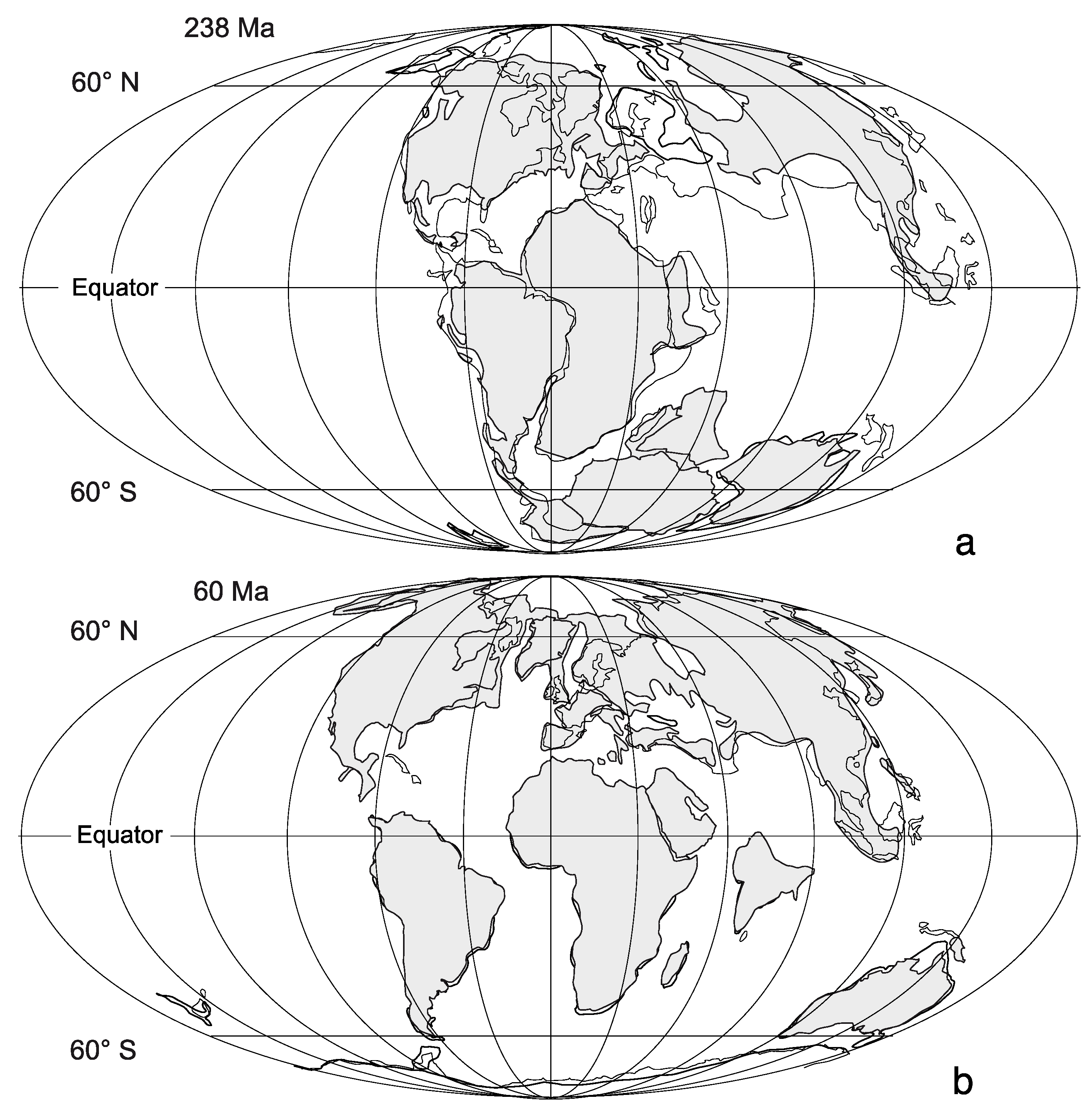
  • The available habitat of rocky shores accessible by intertidal life has varied through geologic time as moderated by the mechanics of plate tectonics. A single large continent like Pangaea 250 million years ago offered a reduced shoreline compared with the wide dispersal of many and much smaller continents as today. The paucity of Triassic rocky shores that remain to be detected in the geologic record is related, in part, to this scenario in plate tectonics.
  • The hard substrate of a rocky shoreline is foundational on any kind of igneous, metamorphic, or sedimentary rock. However, igneous rocks like granite or basalt with greater hardness and higher density wear better against erosion and make a more stable home for colonizing organisms, which are able to colonize and recolonize at a faster rate than rock recession.
  • Changes in global sea level through geologic time have influenced the location of rocky shores, often most prominent along continental margins but also appearing in epicontinental settings far inland during intervals of high sea level.
  • Marine invertebrates and many algae are capable of attachment to a rocky shore by direct cementation or other means, whereas mobile forms adhere by suction of a strong muscular “foot” or by wedging into crevices or other irregularities in the rock surface. Some bivalves and sponges are capable of rock boring. All such groups have a distinct paleontological record.
  • Available data show a steady increase in the number of such marine invertebrates and certain marine algae across geologic time, although membership was modified by the intervention of mass extinctions that affected life in other ecosystems, as well. Latitudinal temperature gradients appear to have varied through geologic time, meaning that analogous diversity gradients from tropical to more temperate settings may have been less pronounced than today.
  • The preservation of rocky-shore species as fossils in their original growth position on a rock substrate is more commonly encountered than once assumed and was typically mediated by sudden catastrophic events ending in burial by rapid rates of rising sea level, storm deposits, or volcanic ejecta such as ash or coarser tephra.
The preponderance of data on which the above conclusions are based derives from the work by geologists and paleontologists in Europe, as well as English-speaking areas in the British Isles, USA, Canada, Australia, and New Zealand. It is hoped this review will attract fresh research from cohorts working elsewhere, especially in Asia, Africa, and South America.

Funding

This research received no external funding.

Acknowledgments

MEJ is grateful to B. Gudveig Baarli for assistance in editing the line drawings for this paper.

Conflicts of Interest

The author declares no conflict of interest.

References

  1. National Geographic Atlas of the World, 11th ed.; National Geographic Society: Washington, DC, USA, 2019; 448p.
  2. Bird, C.F.; Schwartz, M.L. The World’s Coastline; Van Nostrand Reinhold: New York, NY, USA, 1985; 1071p. [Google Scholar]
  3. Carson, R. The Edge of the Sea; Houghton Mifflin Co.: Boston, MA, USA, 1955; 276p. [Google Scholar]
  4. Hecker, R.F. Introduction to Paleoecology; American Elsevier Publishing Co.: New York, NY, USA, 1966; 166p. [Google Scholar]
  5. Selden, P.; Nudds, J. Evolution of Fossil Ecosystems; University of Chicago Press: Chicago, IL, USA, 2004; 160p. [Google Scholar]
  6. Zakharov, D.O.; Bindeman, I.N. Triple oxygen and hydrogen isotopic study of hydrothermally altered rocks from the 2.43–2.41 Ga Vetreny belt, Russia: An insight into the early Paleoprterozoic seawater. Geochem. Colsmochim. Acta 2019, 248, 185–209. [Google Scholar] [CrossRef]
  7. Bindeman, I.N.; O’Neil, J. Earth’s earliest hydrosphere recorded by the oldest hydrothermally-altered oceanic crust: Triple oxygen and hydrogen isotopes in the 4.3–3.8 Ga Nuvvuagittuq belt, Canada. Earth Planet. Sci. Lett. 2022, 586, 117539. [Google Scholar] [CrossRef]
  8. Byerly, G.R.; Lower, D.R.; Walsh, M.M. Stromatolites from the 3300–3500-Myr Swaziland Supergroup, Barberton Mountain Land, South Africa. Nature 1986, 319, 489–491. [Google Scholar] [CrossRef]
  9. Logan, B.W. Cryptozoon and associated stromatolites from the recent, Shark Bay, Western Australia. J. Geol. 1961, 69, 517–533. [Google Scholar] [CrossRef]
  10. Johnson, M.E.; Baarli, B.G. Development of intertidal biotas through Phanerozoic time, pp. 63–128. In Earth and Life; Talent, J.A., Ed.; Springer Science+Business Media: Dordrecht, The Netherlands, 2012; 1100p. [Google Scholar]
  11. Emery, K.O.; Kuhn, G.G. Sea cliffs: Their processes, profiles, and classification. Geol. Soc. Am. Bull. 1982, 93, 644–654. [Google Scholar] [CrossRef]
  12. Bird, E.C.F. Coastal Geomorphology: An Introduction; John Wiley & Sons: Chichester, UK, 2008; 448p. [Google Scholar]
  13. Johnson, M.E. Why are ancient rocky shores so uncommon? J. Geol. 1988, 96, 469–480. [Google Scholar] [CrossRef]
  14. Deny, M.W. Biology and the Mechanics of the Wave-Swept Environment; Princeton University Press: Princeton, NJ, USA, 1998; 329p. [Google Scholar]
  15. Stephenson, T.A.; Stephenson, A. The universal features of zonation between tide-markes on rocky coasts. J. Ecol. 1949, 37, 289–305. [Google Scholar] [CrossRef]
  16. Sunamura, T. Geomorphologyu of Rocky Coasts; John Wiley & Sons: Chichester, UK, 1992; 302p. [Google Scholar]
  17. Johnson, M.E. Islands in Deep Time: Ancient Landscapes Lost and Found; Columbia University Press: New York, NY, USA, 2023; 312p. [Google Scholar]
  18. Twidale, R. Granite Landforms; Elsevier: Amsterdam, The Netherlands, 1982; 372p. [Google Scholar]
  19. Twidale, R. The research frontier and beyond: Granitic terrains. Geomorphology 1993, 7, 187–223. [Google Scholar] [CrossRef]
  20. Brinkhurst, R.O.; Linkletter, L.E.; Lord, E.I.; Connors, S.A.; Dadswell, M.J. A Preliminary Guide to the Littoral and Sublittoral Marine Invertebrates of Passamaquddy Bay; Huntsman Marine Laboratory: St. Andrews, NB, Canada, 1976; 166p. [Google Scholar]
  21. Johnson, M.E.; Baarli, B.G. Erosion and burial of granite rocky shores in the Recent and Late Pleistocene of the Seychelles Islands: Physical and biological perspectives. J. Coast. Res. 2005, 21, 867–879. [Google Scholar] [CrossRef]
  22. Braithwaite, C.J.R. Geology of the Seychelles. In Biogeography and Ecology of the Seychelles Islands; Stoddart, D.R., Ed.; W. Junk Publishers: The Hague, The Netherlands, 1984; pp. 17–38. [Google Scholar]
  23. Suwa, K.; Tokieda, K.; Hoshino, M. Palaeomagnetic and petrological reconstruction of the Seychelles. Precambrian Res. 1994, 69, 281–292. [Google Scholar] [CrossRef]
  24. Taylor, J.D. Coral reef and associated invertebrate communities (mainly molluscan) around Mahé, Seychelles. Philos. Trans. R. Soc. Lond. Ser. B Biol. Sci. 1968, 254, 129–206. [Google Scholar]
  25. Jerrett, A.G. Marine Shells of the Seychelles; Carole Green Publishing: Cambridge, UK, 2000; 149p. [Google Scholar]
  26. Philipps, C.J.; Bellwood, D.R. The hydrodynamics of Lizard Island lagoon, Great Barrier Reef. Coral Reefs 2024, 43, 881–897. [Google Scholar] [CrossRef]
  27. Davey, K. Seashore Life of Australia; New Holland Publishers: Sydney, Australia, 1998; 144p. [Google Scholar]
  28. Friedman, G.M. Breachrocks record Holocene events, including natural disasters. Carbonates Evaporites 2011, 26, 97–109. [Google Scholar] [CrossRef]
  29. Leonard, J.E.; Cameron, B.W. Origin of a high-latitude carbonate beach: Mt. Desert Island, Maine. Northeast. Geol. 1981, 28, 1–28. [Google Scholar]
  30. Barndhardt, W.W.; Kellley, J.T. Carbonate accumulation on the inner continental shelf of Maine; a modern consequence of late Quaternary glaciation and sea-level change. J. Sediment. Res. 1995, 65, 195–207. [Google Scholar]
  31. Dott, R.H., Jr. Cambrian tropical storm waves in Wisconsin. Geology 1974, 2, 243–246. [Google Scholar] [CrossRef]
  32. Eoff, J.D. Sequence stratigraphy of the Upper Cambrian (Furongian, Jiangshanian and Sunwaptan) Tunnel City Group, Upper Mississippi Valley: Transgressing assumptions of cratonic flooding. Sediment. Geol. 2014, 302, 87–101. [Google Scholar] [CrossRef]
  33. Johnson, M.E.; Wilson, M.A.; Redden, J.A. Borings in quartzite surf boulders from the Upper Cambrian basal Deadwood Formation, Black Hills of South Dakota. Ichnos 2010, 17, 48–55. [Google Scholar] [CrossRef]
  34. Johnson, M.E.; Baarli, B.G. Encrusting corals on a latest Ordovician to earliest Silurian rocky shore, southwest Hudson Bay, Manitoba, Canada. Geology 1987, 15, 15–17. [Google Scholar] [CrossRef]
  35. Nelson, S.J.; Johnson, M.E. Jens Munk Archipelago: Ordovician-Silurian islands in the Churchill area of the Hudson Bay Lowlands, Northern Manitoba. J. Geol. 2002, 110, 577–589. [Google Scholar] [CrossRef]
  36. Johnson, M.E.; Rong, J.Y.; Wang, C.Y.; Wang, P. Continental island from the Upper Silurian (Ludfordian Stage) of Inner Mongolia: Implications for eustasy and paleogeography. Geology 2001, 29, 955–958. [Google Scholar] [CrossRef]
  37. Rong, J.; Johnson, M.E.; Deng, Z.; Dong, D.; Yaosong, S.; Baarli, B.G.; Wang, G. Coral-stromatoporoid faunas from the shores of a late Silurian island, Inner Mongolia, North China. Mem. Assoc. Australas. Palaeontol. 2013, 44, 95–105. [Google Scholar]
  38. Johnson, M.E.; Webb, G.E. Outer rocky shores of the Mowanbini Archipelago, Devonian Reef Complex, Canning Basin, Western Australia. J. Geol. 2007, 115, 583–600. [Google Scholar] [CrossRef]
  39. Baarli, B.G.; Webb, G.; Johnson, M.E.; Cook, A.G.; Walsh, D.R. Shoal-water dynamics and coastal biozones in a sheltered-island setting: Upper Devonian Pillara Limestone (Western Australia). Lethaia 2016, 49, 507–523. [Google Scholar] [CrossRef]
  40. De la Beche, H.T. On the Formation of the Rocks of South Wales and South Western England; Memoirs of the Geological Survey of Great Britain; Geological Survey: London, England, 1846; pp. 1–2167. [Google Scholar]
  41. Johnson, M.E.; McKerrow, W.S. The Sutton Stone: An early Jurassic rocky shore deposit in South Wales. Palaeontology 1995, 38, 529–541. [Google Scholar]
  42. Johnson, M.E.; Ledesma-Vázquez, J.; Clark, H.C.; Zwiebel, J.A. Coastal evolution of Late Cretaceous and Pleistocene rocky shores: Pacific rim of northern Baja California, Mexico. Geol. Soc. Am. Bull. 1996, 108, 708–721. [Google Scholar] [CrossRef]
  43. Johnson, M.E.; Hayes, M.L. Dichotomous facies on a Late Cretaceous rocky island as related to wind and wave patterns (Baja California, Mexico). Palaios 1993, 8, 385–395. [Google Scholar] [CrossRef]
  44. Santos, A.; Mayoral, E.; da Silva, C.M.; Cahão, M.; Johnson, M.E.; Baarli, B.G. Miocene intertidal zonation on a volcanically active shoreline: Porto Santo in the Madeira Archipelago, Portugal. Lethaia 2011, 44, 26–32. [Google Scholar] [CrossRef]
  45. Rebelo, A.C.; Rasser, M.W.; Kroh, A.; Johnson, M.E.; Ramalho, R.S.; Melo, C.; Uchman, A.; Berning, B.; Silva, L.; Zanon, V.; et al. Rocking around a volcanic island shelf: Pliocene rhodolith beds from Malbusca, Santa Maria Island (Azores, NE Atlantic). Facies 2016, 62, 22. [Google Scholar] [CrossRef]
  46. Johnson, M.E.; Uchman, A.; Costa, P.J.M.; Ramalho, R.S.; Ávila, S.P. Intense hurricane transports sand onshore: Example from the Pliocene Malbusca section on Santa Maria Isalnd (Azores, Portugal). Mar. Geol. 2017, 385, 244–249. [Google Scholar] [CrossRef]
  47. Darwin, C. Geological Observations on the Volcanic Islands Visited during the Voyage of the H.M.S. Beagle., Together with Some Brief Notices on the Geology of Australia and the Cape of Good Hope. Being the Second Part of the Geology of the Voyage of the Beagle, under the Command of Capt. FitzRoy, RN.N. during the Years 1832 to 1836; Smith, Elder & Co.: London, UK, 1844; 175p. [Google Scholar]
  48. Baarli, B.G.; Santos, A.G.; Mayoral, E.J.; Ledesma-Vázquez, J.; Johnson, M.E.; da Silva, C.M.; Cachão, M. What darwin did not see: Pleistocene fossil assemblages on a high-energy coast at Ponta das Bicudas, Santiago, Cape Verde islands. Geol. Mag. 2013, 150, 83–189. [Google Scholar] [CrossRef]
  49. Wegener, A. The Origin of Continents and Oceans; (first English edition translated from the third German edition); Methuen & Co., Ltd.: London, UK, 1924; 246p. [Google Scholar]
  50. Johnson, M.E. Uniformitarianism as a guide to rocky-shore ecosystems in the geological record. Can. J. Earth Sci. 2006, 43, 1119–1147. [Google Scholar] [CrossRef]
  51. Husson, J.M.; Peters, S.E. Nature of the sedimentary rock record and its implications for Earth System evolution. Emerg. Top. Life Sci. 2018, 2, 125–136. [Google Scholar] [PubMed]
  52. Marsaglia, K.M.; Klein, G.D. The paleogeography of Paleozoic and Mesozoic storm depositional systems. J. Geol. 1983, 91, 117–142. [Google Scholar] [CrossRef]
  53. Pietzsch, K. Geologie von Sahzen; Veb Deutcher Verlag der Wissenschaften: Berlin, Germany, 1962; pp. 17–22. [Google Scholar]
  54. Surlyk, F.; Sørensen, A.M. An early Campanian rocky shore at Ivö Klack, southern Sweden. Cretac. Res. 2010, 31, 567–576. [Google Scholar] [CrossRef]
  55. Gale, A.S.; Sørensen, A.M. Taxonomy and palaeoecology of thoracican cirripedes (Crustacea) from a Campanian rocky shoreline at Ivö Klack, southern Sweden. Cretac. Res. 2015, 54, 212–242. [Google Scholar] [CrossRef]
  56. Wilson, M.; Taylor, P.D. Palaeoecology of hard substrate faunas from the Cretaceous Qahlah Formation of the Oman Mountains. Palaeontology 2001, 44, 21–41. [Google Scholar] [CrossRef]
  57. Zhang, L.; Hay, W.W.; Wang, C.; Gu, X. The evolution of latitudinal temperature gradients from the latest Cretaceous through the Presnt. Earth-Sci. Rev. 2019, 189, 147–158. [Google Scholar] [CrossRef]
Figure 1. Global representation of today’s continents and oceans on a Mollweide projection showing major ocean spreading zones. Numerals on black triangles denote the locations of distinct areas with prominent granite rocky shores on Mount Desert Island in coastal Maine, USA (1); the Seychelles Islands (2), and Lizard Island on the Great Barrier Reef off the coast of Queensland, Australia (3). The numbered black dots mark the location of a dozen paleoislands dominated by rocky shores with fossil biotas ranging in age through the Phanerozoic from the late Cambrian (1 and 2) to the last inter-glacial stage of the Pleistocene in the Seychelles Islands (12).
Jmse 12 01399 g001
Figure 2. Map of Mount Desert Island off the coast of Maine in the Gulf of Maine on the Atlantic Ocean. The main roads around the island are shown by dashed lines. The single access onto the island (State Highway 3) is linked to the mainland by a short bridge. SB marks the location of Sand Beach east of Somes Sound.
Jmse 12 01399 g002
Figure 3. View north along a granite rocky shore that intersects Sand Beach on Mount Desert Island. People can be seen congregating in the far distance on Sand Beach (right) and at the break between forest and rocks (left). Rocks densely covered by algae with a green tinge show the extent of exposure during extreme low tide.
Jmse 12 01399 g003
Figure 4. Images of the dominant marine invertebrates and marine algae from the mid-littoral zone and infralittoral fringe on granite rocky shores adjacent to Sand Beach on Mount Desert Island: (a) Densely crowded barnacles (Semibalanus balanoides) less than 5 mm in diameter; (b) Densely crowed mussels (Mytilus edulis) up to 9 cm in length; (c) Marine algae from the infralittoral fringe showing a tidal pool with rockweed, Fucus distichus (lower right) and concentrations of Irish Moss, Chondrus crispus (upper left).
Jmse 12 01399 g004
Figure 5. Map showing a cluster of a dozen granite islands in the northern, inner part of the Seychelles archipelago located in the Indian Ocean off the east coast of Africa. Arrows point to Victoria, the capital city, and Port Launay, both on Mahé the largest island.
Jmse 12 01399 g005
Figure 6. Fluted development of granite rocky shores due to chemical weathering on the south side of the bay at Port Launay on Mahé Island (see Figure 5 for location). A sample grid (center) is well exposed at maximum low tide (person for scale).
Jmse 12 01399 g006
Figure 7. Marine invertebrates from the intertidal zone at Port Launay on the leeward side of Mahé Island: (a) Gastropod Littorina undulata from the supralitltoral fringe occupying a crack in the granite (pencil for scale); (b) Granite surface in the mid-littoral zone initially encrusted by oysters in the species Crassostrea cucullate but overlain by encrusting barnacles in the species Tetraclita squamosa as well as mobile limpets belonging to the species Cellana radiata (pen cap 3.5 cm for scale); (c) Granite knob exposed at lowest tide in the middle of the bay densely covered by a colonial mat of soft corals belonging to the genus Palythoa (pen 14 cm in length for scale).
Jmse 12 01399 g007
Figure 8. Line of large granite boulders seaward of the beach along the west shore of Praslin Island that exhibit intertidal zonation in a rough-water setting. Swimming person for scale (left).
Jmse 12 01399 g008
Figure 9. Elements of biota inhabiting the inter-tidal zone and infralittoral fringe in a windward, rough-water setting on Praslin Island: (a) Mixed populations of barnacles (Balanus tintinnabulum and Tetraclita squamosa) interspersed with the limpet Cellana radiata (on average 1.5 cm in diameter) in the mid-littoral zone; (b) Thickets of brown algae from the genus Turbinaria that dominate over patches with encrusting red coralline algae and soft corals in the infralittoral fringe (pen for scale); (c) Rare occurrence the coral Pocillopora damincornis attached to granite in the infralittoral fringe (20 cm across in diameter).
Jmse 12 01399 g009
Figure 10. Topographic map covering Lizard Island and a related cluster of islets including Palfrey, South, and Bird (grey shading represents shallow-water shelf).
Jmse 12 01399 g010
Figure 11. Faunal elements from the inter-tidal zone and infralittoral fringe in a windward, rough-water setting off Trawler Beach on the south side of Lizard Island: (a) Sparse populations of the star limpet Patelloida saccarina including vacant home stations (each square is 10 cm on a side); (b) Dense concentrations of the comb oyster, Lopha cristagalli occur in a middle band (pen for scale); (c) Scattered populations of another bivalve called the jewel box, Chama limbula, occupy a third and distinctly lower band (pen cap for scale); (d) large granite block encrusted by oysters at the top, jewel box bivalves in the middle, and a solid mat with soft corals in the genus Palythoa from the infralittoral fringe (author for scale).
Jmse 12 01399 g011
Figure 12. Faunal elements of extant marine invertebrates preserved as contemporary fossils in the Palfrey Island beachrock: (a) Cross-sections through the gastropod Throchus lineatus and stony coral from the genus Favitres (cap to water bottle is 7 cm in diameter); (b) Disarticulated and worn shells from the bivalve genus Tridacna together with a red granite cobble.
Jmse 12 01399 g012
Figure 13. Histogram with the geologic time scale on the y-axis and the number of documented rocky-shore localities registered to each of twelve geologic time periods on the x-axis as of 2012. Absolute time in millions of years is also shown on the x-axis.
Jmse 12 01399 g013
Figure 14. Pie diagram showing the geographic source distribution of places mainly by continents where researchers carried out studies eventually published on prehistoric rocky-shore biotas.
Jmse 12 01399 g014
Figure 15. Coastal area along Hudson Bay in northern Manitoba that overlaps with a former, late Ordovician paleoshore and paleoisland: (a) One of the distal quartzite boulders exposed during low tide with layers of dolostone dipping off to the north into the bay; (b) Example of a boulder-encrusting coral belonging to the genus Favosities.
Jmse 12 01399 g015
Figure 16. Leeward flank of the late Silurian Bater Island in China’s Inner Mongolia: (a) Boundary between dark igneous diorite rocks (below) and silty limestone above with author seated for scale; (b) Cluster of large stromatoporoids at the changeover from igneous to sedimentary rocks (marker shows 5 cm for scale).
Jmse 12 01399 g016
Figure 17. Forereef facies within the great Devonian barrier reef dipping away to the present-day south off a paleoisland in the Oscar Range (boab tree for scale).
Jmse 12 01399 g017
Figure 18. Reproduction of the original coastal-outcrop drawing by De la Beche from 1846 showing the geological unconformity at Dunraven Bay between tilted Carboniferous Limestone and flat Jurassic limestone. The spot where the figure stands is accessible only during extreme low tide in the Bristol Channel.
Jmse 12 01399 g018
Figure 19. Example of a colonial coral belonging to the species Tarbellastraea reussinna in cross-section showing its attachment to the basalt surface of a narrow shelf on Ilhéu de Cima off the shores of Porto Santo in the Madeira archipelago.
Jmse 12 01399 g019
Figure 20. Top of a former sea cliff on Ilhéu de Cima with an irregular surface seen in profile showing a well-preserved encrustation by coralline red algae having a pustular texture on a basalt substrate (pen for scale is 12 cm long). The alga is overlain by volcanic ash and sand-size lapilli.
Jmse 12 01399 g020
Figure 21. View of fluted granite cliffs at the south end of the beach at Grand Anse on La Digue Island showing large patches of limestone coatings left by sheeted coralline red algae. The coatings also occupy the underside of overhanging cliffs (person for scale).
Jmse 12 01399 g021
Figure 22. Global reconstructions of the continents and oceans from the early Mesozoic and early Cenozoic eras: (a) Pangaea during the mid-Triassic approximately 238 million years ago; (b) Dispersal of continents during early Paleogene Period approximately 60 million years ago. Modified from Johnson [49].
Jmse 12 01399 g022
Figure 23. Changes in the diversity of the rocky-shore biota through geologic time are plotted in four overlapping clusters classified as having Archaic, Paleozoic, Mesozoic, and Cenozoic origins.
Jmse 12 01399 g023
Disclaimer/Publisher’s Note: The statements, opinions and data contained in all publications are solely those of the individual author(s) and contributor(s) and not of MDPI and/or the editor(s). MDPI and/or the editor(s) disclaim responsibility for any injury to people or property resulting from any ideas, methods, instructions or products referred to in the content.

