Review

Exposure of Carboniferous Granitoids on Triassic–Jurassic Seashores in the Western Caucasus: A Stratigraphical Review

by
Dmitry A. Ruban
Department of Organization and Technologies of Service Activities, Institute of Tourism, Service and Creative Industries, Southern Federal University, 23-ja Linija Street 43, Rostov-on-Don 344019, Russia
J. Mar. Sci. Eng. 2024, 12(9), 1623; https://doi.org/10.3390/jmse12091623
Submission received: 6 August 2024 / Revised: 10 September 2024 / Accepted: 10 September 2024 / Published: 12 September 2024
(This article belongs to the Special Issue Feature Review Papers in Geological Oceanography)

Abstract

:
Granitoids are known to crop out on ancient seashores, but the related geological evidence remains limited. The information from the Western Caucasus sheds light on the stratigraphical distribution of coarse siliciclastic beds associated with late Carboniferous granitoids of the Dakh, Rafabgo, and Sakhray crystalline massifs. For the purposes of this study, the available information was reviewed and verified against the modern stratigraphical scales. It is established that the considered coarse sisliciclastic beds occur at five stratigraphical levels of the Triassic–Jurassic succession. A rocky seashore with granitoid exposures existed for a short time around the Sakhray and probably Rufabgo massifs at the very beginning of the Triassic. The Dakh Massif possessed such a shore twice (at least), i.e., in the Norian–Rhaetian and the Early Toarcian. However, it cannot be excluded that rocky shores persisted there for >50 Ma. Generally, the Western Caucasus provides an example of granitoid exposures on Mesozoic seashores and adds knowledge of the global distribution of rocky shores in the Triassic and Jurassic periods.

1. Introduction

Rocky shores constitute a specific depositional environment [1,2,3,4,5] with a relatively poor potential for preservation in the geological record. The works by Johnson [6,7,8] laid a conceptual foundation for the development of the related ideas, which are important to marine geology, stratigraphy, sedimentology, palaeogeography, and palaeoecology. During decades of research, evidence of this depositional environment was collected in many regions and geological time slices [9,10,11,12,13,14,15]. Particularly, it became clear that some modern and ancient rocky shores are linked to exposure of granitoids [16,17,18]. If so, attention to coarse siliciclastic beds on margins of granitic massifs can facilitate the understanding of ancient rocky shores; the related features are interesting not only theoretically, but also practically, i.e., as objects of geoheritage and geotourism [19,20,21,22,23].
In a relatively small area of the Western Caucasus (western part of the Greater Caucasus orogen), three crystalline massifs representing Late Paleozoic granitoids are known [24]. The evidence of several coarse siliciclastic beds associated with these massifs accumulated and was discussed for about a century [23,25,26,27,28], but this knowledge remained limited, fragmented, and non-systematized. Moreover, a joint consideration of some old (“forgotten”) and very new works can shed light on exposure and wave abrasion of granitoids in the Mesozoic. Apparently, these really spectacular geological records of ancient rocky shores were almost missed in the geological research, despite their potentially international importance. Moreover, a consideration of these records can help to fill some gaps in the understanding of the geological evolution of the Western Caucasus. The information about possible granitoid exposure on Triassic–Jurassic seashores of the Western Caucasus [23,25,26,27,28] is already significant relative to the general scarcity of this kind of evidence [8]. But this information is available in an imperfect form, and, thus, it is urgent to review it, with certain updates, improvements, and additions.
The objective of the present work is to review the stratigraphical distribution of the coarse siliciclastic beds associated with Late Paleozoic granitoids of the Western Caucasus. Particularly, the presence of these beds and granitoids in Mountainous Adygeya is considered. This review becomes possible thanks to new, original field observations in the study area and critical consideration of the available, but yet to be systematized, published evidence. Extraction and reinterpretation of the information from some old works [27,28] can facilitate the understanding of the presence of several coarse siliciclastic beds. The present work continues, but does not replicate, the discussion started in the previous work [23]; this paper differs from the latter substantially and presents more advanced interpretations. It should be stressed that this review is essentially stratigraphical and deals with rock relationships and ages. Indeed, composition of coarse siliciclastic beds is considered, but only generally; a new, fully separate research project will be necessary to investigate this composition in detail. Nonetheless, the reviewed stratigraphical information creates a basis for further, pure sedimentological investigations.

2. Geological Setting

The study area is a central part of so-called Mountainous Adygeya, which is a part of the Western Caucasus in southwestern Russia (Figure 1a). Tectonically, this area belongs to the western segment of the late Cenozoic orogen, the development of which marked the active contacts between the Eurasian lithospheric plate in the north and smaller plates (particularly, the Anatolian plate) in the south [29,30,31]. The ongoing orogeny was preceded by a long-term evolution of northern Neo-Tethyan island arcs and back-arc basins [32,33,34].
The geology of the study area is heterogeneous (Figure 1b). It is dominated by Lower–Middle Jurassic siliciclastic rocks and Upper Jurassic carbonate and siliciclastic rocks [35]. The former are folded and faulted in a complex manner; principally, there is a northwest–southeast-trending syncline with an axis located between the Dakh and Sakhray massifs [35]. The Upper Jurassic sedimentary complex forms a kind of north-dipping monocline, and this complex covers older rocks transgressively from the north and the west.
There are three crystalline massifs (Dakh, Rufabgo, and Sakhray—Figure 1b), which consist chiefly of Late Paleozoic rocks (Figure 2a), the exact age of which is established as late Carboniferous [37]. One massif (at least) includes also Proterozoic and Paleozoic metamorphic rocks (Figure 2b). All massifs associate with Triassic sedimentary rocks (Figure 2c,d). Apparently, the crystalline massifs and Triassic complexes are represented in uplifted tectonic blocks affected by deep erosion. The boundaries of these blocks and the related major faults are yet to be known precisely.
The Mesozoic stratigraphy of the study area is known rather well [24,25,38,39,40,41,42], although many details and even the nomenclature of lithostratigraphical units are yet to be fixed. The local sedimentary succession is dominated by siliciclastic and carbonate packages with a total thickness measuring several thousand meters and interrupted by a series of major hiatuses (Figure 3), often marked by coarse siliciclastic beds (Figure 2e). The most notable and widely distributed packages include dark and hard limestones of the Yatyrgvarta Formation, shales of the Sakhray Group, grey-to-black shales of the Psebay and Dzhangur formations, massive limestones and dolostones of the Gerpegem Formation, and siliciclastic red beds of the Mezmay Formation. These deposits accumulated in a tropical and subtropical sea on the margin of the Neo-Tethys Ocean (Figure 1c), which embraced back-arc basins [23,43], although temperate conditions could also exist in some time slices [44]. In the Norian–Rhaetian and the Oxfordian–Kimmeridgian intervals, reefal ecosystems flourished in the study area and marked a development of vast carbonate platforms.

3. Material and Methods

The information of the presence of coarse siliciclastic beds associated with the three crystalline massifs known from the study area was collected over the course of several years of field investigations, as well as from the literature. Particularly, one should note that the geology of Mountainous Adygeya was studied intensively in the first half of the 20th century [27,28], but that information remained almost forgotten later. This creates a biased vision because the study area is relatively large, and its total geological reinvestigation requires the efforts of dozens of specialists and many years (even decades) of field works. Moreover, some places are poorly accessible due to steep slopes, dense vegetation cover, and absent trails, and finding small outcrops can be challenging there. This is why the old works should not be omitted, and they can bear a lot of precious information that makes a substantial addition to the present knowledge. Importantly, the old works were based on investigations carried out and reported carefully.
To avoid the above-mentioned biased vision, a careful search in libraries and on-line archives was carried out to find the old works dealing with the geology of Mountainous Adygeya. It was established that two of them [27,28] contain much important information about coarse siliciclastic beds associated with granitoids of the study area. Indeed, this information can be used together with the newest lines of evidence [23,25,26] and the novel field observations. Finding old sources and reinterpreting their content are important elements of the present review. Indeed, the latter also takes into account the results of new, original field investigations.
A total of five localities representing coarse siliciclastic beds associated with the three crystalline massifs of Mountainous Adygeya are considered in this review (Figure 1b). To avoid further misunderstandings, these localities are not named, but numbered. Localities 1 and 5 were detected in the field, and they were also characterized in the literature [23,26]. The other localities were detected only in the literature [25,27,28], and they were not revisited due to the limited accessibility (the appropriate quality of the published information from these localities does not require revisiting them). The information available in both the old and new sources is detailed enough to be used for the purposes of the present analysis. One should note that the considered crystalline massifs are relatively small (Figure 1b), and deposits of ancient shores are rather rare in the geological records [8]. Therefore, the considered number of the localities known in the study area seems to be appropriate for this review. Moreover, the presence of five localities representing ancient rocky shores in one area makes the area almost unique on the global scale.
The procedures of the present review are rather elementary. Nonetheless, they required much effort and complex solutions. Moreover, these procedures are essential and typical to regional lithostratigraphical investigations.
First of all, the position of each locality relative to the crystalline massifs was verified. Then, stratigraphical relationships of coarse siliciclastic beds with other rock packages and granitoids were documented and, where necessary, interpreted. Although this paper has a stratigraphical focus, the principal composition peculiarities of the beds were considered. In the considered localities, the beds do not bear fossils that would permit the establishment of their age directly. However, the noted attention to the relationships with the other rocks with known ages (contemporary understanding of the local stratigraphy (Figure 3) was followed) and some compositional peculiarities permitted judgments of the age of the beds at all five localities. On the basis of this knowledge, a stratigraphical correlation (a traditional, but powerful tool in stratigraphical, sedimentological, and palaeogeographical research [45,46,47,48,49]) of the coarse siliciclastic beds associated with the crystalline massifs was carried out. This permitted the proposition of a general model depicting the chronology of exposure of Carboniferous granitoids of the study area on Triassic and Jurassic seashores.

4. Results

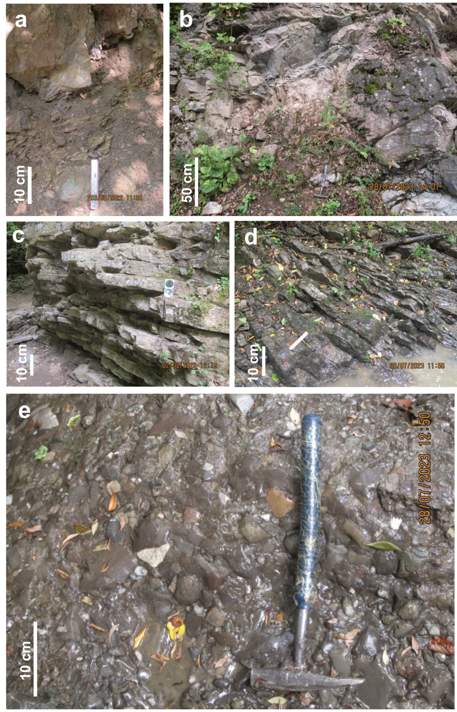
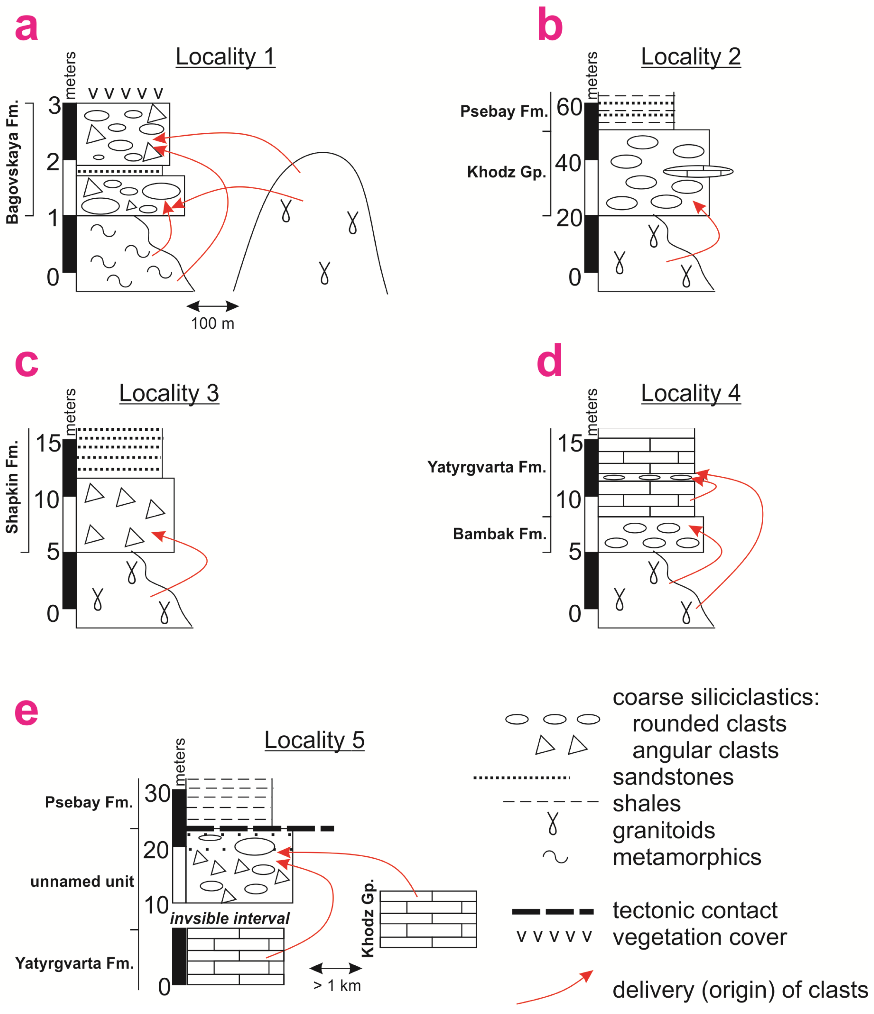
4.1. Key Localities of Coarse Siliciclastic Beds Associated with Three Crystalline Massifs

The occurrence of coarse siliciclastic beds in the considered localities is mentioned below. Attention is paid to the general view of these localities and the contacts of principal lithologies. This information is essential for the subsequent establishment of ages of these localities and their correlation.
Locality 1 is found near the mouth of the Lipovy Stream (a small right tributary of the Belaya River) and the northern periphery of the Dakh Crystalline Massif (Figure 1b). There, a thin (~2 m) package of conglomerates crops out. These conglomerates overlay transgressively Proterozoic and Paleozoic metamorphic rocks of the noted massif (Figure 4a). Their contacts with any other sedimentary packages are not registered, but these coarse siliciclastic beds were attributed provisionally to the basal horizons of the Bagovskaya Formation (a former lithostratigraphical unit which is understood presently as a middle part of the Psebay Formation—Figure 3) [23]. These conglomerates include numerous clasts of Carboniferous granitoids of the Dakh Crystalline Massif [26]. These granitoids crop out very closely to Locality 1 (Figure 4a).
Locality 2 corresponds to the watershed between the Syuk River and the Grushevaya River (both are right tributaries of the Belaya River) and the upper parts of their valleys; this is the southeastern edge of the Dakh Crystalline Massif (Figure 1b). This locality was characterized initially in the work by Vyalov and Nikshich [28], whose descriptions were later confirmed and extended by Diakonova-Savelieva [27]. According to these authors, a package of conglomerates with well-rounded granitoid clasts (up to 15 cm in size) overlays granitoids (Figure 4b). Interestingly, this package also includes small lenses of spotted, reddish limestones with a thickness of ~2.5 m. These limestones are similar to the Khodz Group, which bears reefal limestones (Figure 3). If so, it can be postulated that the considered packages of conglomerates from Locality 2 can be assigned to the Khodz Group (Figure 4b). As this can be deduced from the descriptions offered by Vyalov and Nikshich [28], this conglomerate package is overlain by Lower Jurassic sandstones and shales, which represent the Psebay Formation (Figure 4b).
Locality 3 hosts a borehole drilled south of Dakhovskaya village, where the northern periphery of the Dakh Crystalline Massif is overlain by a thick (>150 m) Upper Triassic–Middle Jurassic sedimentary cover (Figure 1b). The evidence from this locality was reported by Chaitsky et al. [25]. According to these authors, granitoids are overlain by a bed (7 m) composed of angular clasts made of these igneous rocks (Figure 4c). This bed is thought to be a result of physical weathering of granitoids [25]. It is overlain conformably by arkose and then quartz sandstones of the Shapkin Formation (Figure 3), and the bed can be considered as a basal part of this formation (Figure 4d).
Locality 4 corresponds to the middle part of the valley of the Sakhray River (a right tributary of the Dakh River, which flows to the Belaya River), where it crosses the Sakhray Crystalline Massif (Figure 1b). There, a thin (~3 m) package of conglomerates with quartz clasts and mica grains transgressively overlays granitoids (Figure 4d). These deposits were reported by Vyalov and Nikshich [28]. The upper part of the section is made of hard limestones, which are typical to the Yatyrgvarta Formation (Figure 3). Diakonova-Savelieva [27] noted the existence of conglomerate interbeds in these limestones; these conglomerates bear rare granitoid pebbles and common limestone pebbles (Figure 4d).
Locality 5 is situated in the lower part of the valley of the Gosh River (a left tributary of the Sakhray River), close to the southwestern edge of the Sakhray Crystalline Massif (Figure 1b). There, a package of conglomerate–breccias with both angular and rounded clasts of different sizes and a visible thickness of ~12 m crops out (Figure 4e). Initially, it was reported by Ruban [23] and reconsidered by Ruban et al. [24]. New investigations showed that these deposits include numerous clasts of Lower Triassic limestones (Yatyrgvarta Formation) and Upper Triassic limestones (Khodz Group). The former crop out at the same locality, and contemporary exposures of the latter are located close to the Sakhray Crystalline Massif (Figure 4e). Some clasts (e.g., quartz clasts) from the considered package of conglomerate–breccias can be interpreted as products of destruction of granitoids, although such an interpretation is highly hypothetical. Due to the local tectonic complexity, the lower and upper contacts of this package remain invisible, and it is represented in a small tectonic block exhibited among Lower Jurassic fine siliciclastics of the Psebay Formation (Figure 3). Nonetheless, the local geological setting is such that the presence of the Yatyrgvarta Formation close to the base of the package of conglomerate–breccias is clear (Figure 4e).
The information presented above implies that localities 1, 2, and 4 represent ancient granitoid seashores. Undoubtedly, Locality 5 also represents a rocky shore [23], although with exposures of limestones, not granitoids. Nonetheless, this locality is of utmost importance in the present study because it marks non-exposure of the Sakhray Crystalline Massif at the time of accumulation of conglomerate–breccias. Locality 3 does not permit the hypothesis of the presence of a rocky seashore because the basal part of the Shapkin was deposited where granitoids were exposed directly on land, and sandstones of this formation mark marine deposition. Anyway, this locality is relevant to each study when local exposures of granitoids is addressed.

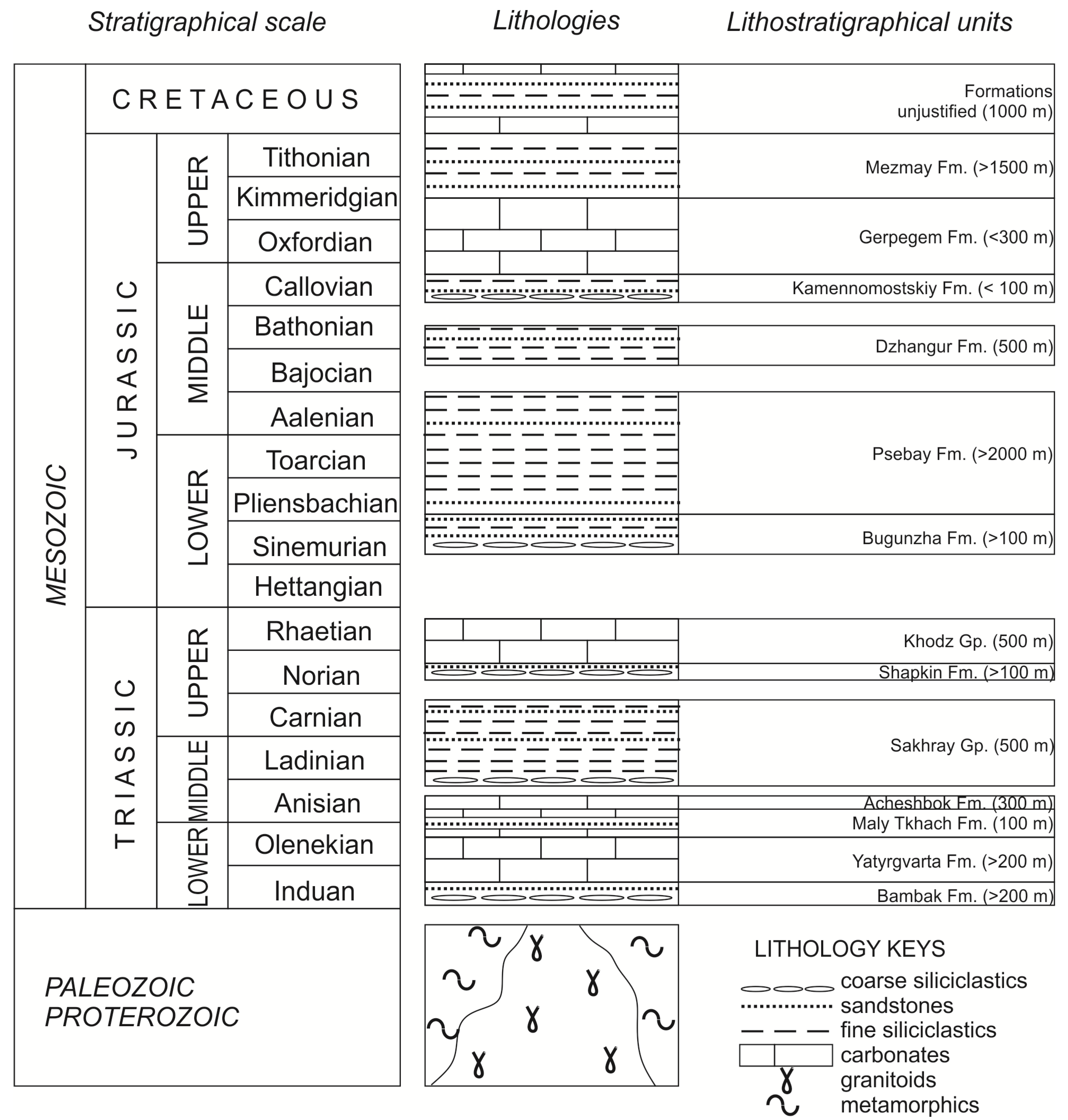
4.2. Ages of Coarse Siliciclastic Beds Associated with Crystalline Massifs

The presented characteristics of the considered localities of the coarse siliciclastic beds (Figure 4a–e) facilitates establishing their ages and correlation. Indeed, the regional stratigraphy (Figure 3) is taken into account for the purpose of the related interpretations.
The age of conglomerates from Locality 1 is unclear due to the absence of visible contacts with the other sedimentary rocks (Figure 4a). However, the presence of clasts of sedimentary rocks and siderite concretions, which are typical to the Psebay Formation, indicates that the age of the conglomerates is younger than the time when the lower part of the noted formation accumulated [26]. If so, these conglomerates can be linked to the basal horizons of the Dzhangur or Kamennomostskiy formations, i.e., they can be either late Bajocian or early Callovian in age (Figure 3). However, these options should be ruled out because the noted formations cannot crop out locally, taking into account the topography and the tectonics of the study area. If so, the only acceptable option is to prove the earlier proposition [23] of the assignment of these conglomerates to the former Bagovskaya Formation [40] and, thus, an early Toarcian age.
The presence of highly specific and, thus, easy-to-distinguish limestones in conglomerates of Location 2 (Figure 4b) implies that these coarse siliciclastics were deposited synchronously with the Khodz Group consisting of such limestones (Figure 3). This group accumulated in the Late Triassic (Figure 3). Diakonova-Savelieva [27] and Vyalov and Nikshich [28] made similar conclusions. If so, the age of these conglomerates is middle Norian–early Rhaetian.
The age of breccia from Locality 3 is no younger than early Norian, when the Shapkin Formation, at the base of which they occur (Figure 4c) [25], accumulated (Figure 3). Although weathering of subaerially exposed granitoids could be a long-term process, this breccia formed, most probably, together with a local tectonic uplift at the Carnian–Norian transition, which interrupted the deposition of the Sakhray Group (Figure 3). If even some weathering products accumulated earlier, their thin cover was eroded as a result of this uplift.
The position of conglomerates of Locality 4 between granitoids and the Yatyrgvarta Formation (Figure 4d) [28] means that these conglomerates should be attributed to the Bambak Formation of an early Induan age (Figure 3). The presence of this formation consisting of coarse siliciclastics in the study area was documented by Chaitsky et al. [25].
Conglomerate–breccias from Locality 5 pose a true challenge for the stratigraphical interpretation due to unclear contacts with the other sedimentary packages (Figure 4e). Ruban [23] attributed it to the Bambak Formation, but new observations [24] imply that these deposits are no older than the Khodz Group of a Late Triassic age (Figure 3), because clasts of its characteristic limestones are found in the conglomerate–breccias (this observation was also proven in the course of new field investigations in the summer of 2024). However, these conglomerate–breccias cannot represent basal horizons of the Psebay Formation (the Bugunzha Formation is locally absent) of a Jurassic age (Figure 3) because of the presence of an angular unconformity between the package of conglomerate–breccias and the Psebay Formation. The dip direction and angle of conglomerate–breccias is similar to that of Triassic deposits [23] and differs strikingly from those of the younger Psebay Formation. If so, the only acceptable option is that this coarse siciliclastic bed is older than the Khodz Formation and younger than the Psebay Group. Apparently, its age ranges within the late Rhaetian–early Hettangian interval. A bit younger, late Hettangian–early Sinemurian age cannot be excluded, but it is rather improbable because deposits of this age (if present) should be related to the Psebay Formation and share its structural setting.

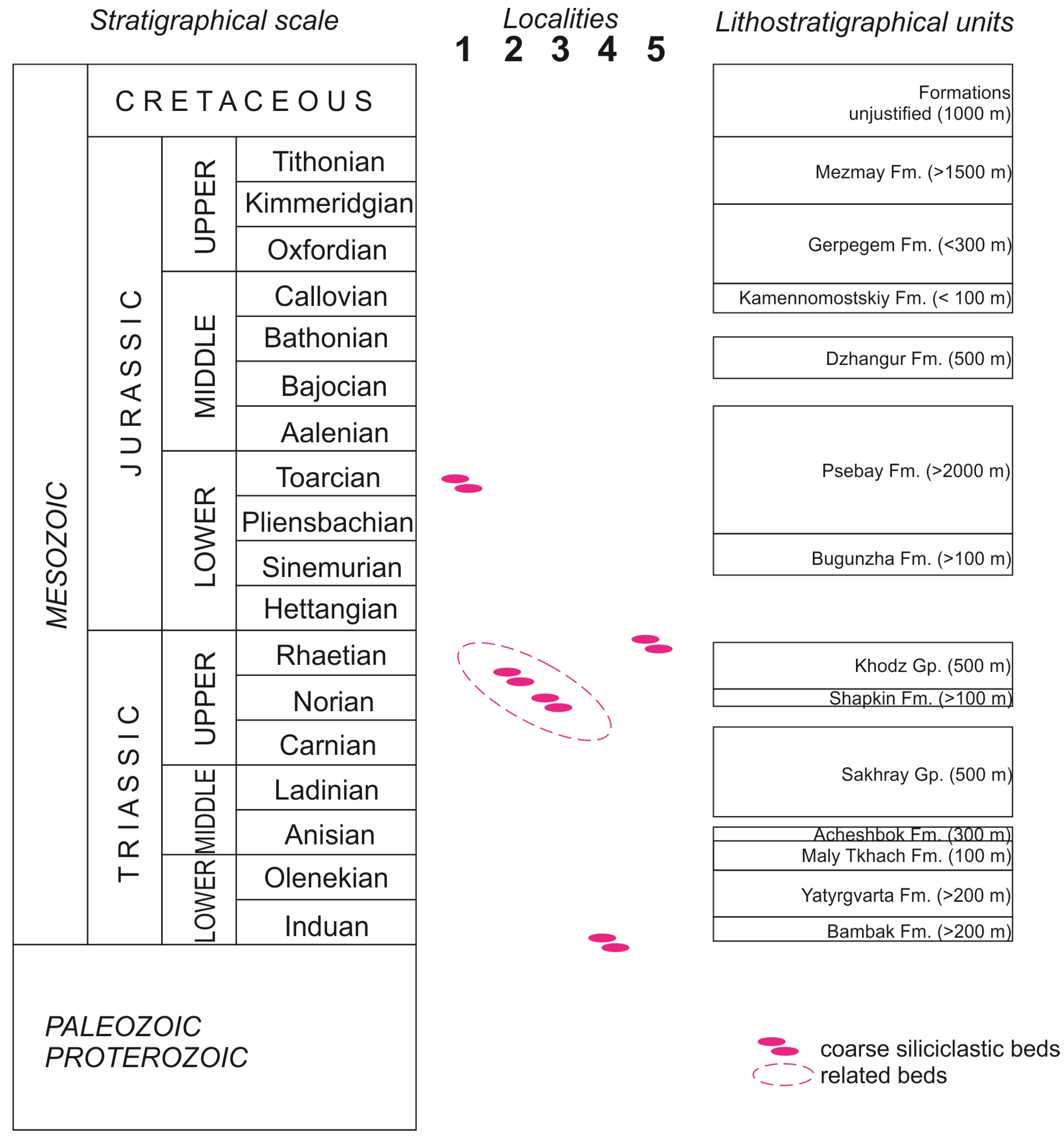
4.3. Stratigraphical Correlation of Coarse Siliciclastic Beds Associated with Crystalline Massifs

The established ages of the coarse siliciclasitc beds associated with the crystalline massifs of the study area (see above) and their justification against the local stratigraphical scheme (Figure 3) make possible a stratigraphical correlation of these beds (Figure 4). Generally, these beds occur at five stratigraphical levels, some of which correspond to the known hiatuses. At each level, the only local distribution of the beds can be documented, and it is limited to the peripheral parts of the crystalline massifs. Nonetheless, two beds can be grouped provisionally (Figure 5). Localities 2 and 3 represent southern and northern peripheries of the Dakh Crystalline Massif, respectively (Figure 1b). One can hypothesize that the deposition of breccias from Locality 3 postdated the denudation of the massif before a further transgression, and the deposition of conglomerates from Locality 2 marked this transgression, which affected remote parts of this massif (see palaeogeographical interpretations below).
Besides the considered localities, there is some other information related to the Triassic–Jurassic evolution of the crystalline massifs in the study area. First, Chaitsky et al. [25] used borehole data and noted the existence of the Bambak Formation in the vicinity of Kamennomostskiy town in the very north of the study area (Figure 1b), where conglomerates of this unit underlay limestones of the Yatyrgvarta Formation. Principally, this means the existence of this formation in the northern part of the study area, where the Rufabgo Crystalline Massif is located (Figure 1b). Despite several attempts, observations made in the valley of the Syryf River, which cuts this massif, do not either prove or disprove the presence of these lower Induan conglomerates above granitoids because outcrops of the latter are very small and slopes above them are covered by soil and vegetation. However, the above-mentioned information [25] means that these conglomerates can be hypothesized there.
Second, the Kamennomostskiy Formation of an early–middle Callovian age (Figure 3) underlays Late Jurassic limestones everywhere in the western and northern parts of the study area (Figure 1b). The lower part of this formation consists of conglomerates (Figure 3), which include clasts of various sandstones and Triassic limestones [40]. This formation does not and did not overlay granitoids of the Sakhray Crystalline Massif, which remained covered by the Bambak and Yatyrgvarta formations during the Triassic–Jurassic. The same can also be true for the Rufabgo Crystalline Massif, although the contacts of granitoids with sedimentary packages are not visible there. However, it appears that the Kamennomostskiy Formation may overlay directly granitoids of the Dakh Crystalline Massif (Figure 1b). The present state of the knowledge does not permit proving this idea due to the very limited accessibility of the related parts of the study area, and an exposure of granitoids of this massif at the time of the Bathonian–Callovian hiatus can only be hypothesized.

5. Discussion and Conclusions

5.1. Modelling Exposure of Crystalline Massifs on Ancient Seashores

The stratigraphical information about the coarse siliciclastic beds associated with Late Paleozoic granitoids (Figure 4a–e and Figure 5) provides evidence of an exposure of the latter on rocky seashores in the Triassic–Jurassic history of the study area (Figure 6). The proposed model and the related palaeogeographical interpretations are given below. This pioneering reconstruction offers a new vision of the local geological history, but is tentative and, thus, can be detailed and even corrected in the light of future investigations.
In the beginning of the Triassic, all three crystalline massifs were exposed, and a wave abrasion of the related rocky shores resulted in a widespread accumulation of the Bambak Formation on a northeastern periphery of a large land mass (Figure 7a). The presence of megaclasts [25] makes realistic the idea of possible severe storms and even tsunamis [23]. Although the global sea level did not rise in the Early Triassic [50], a wide regional transgression led to the drowning of the Rufabgo and Sakhray massifs, which, probably, were not exposed again during the Triassic–Jurassic interval (Figure 6). Despite multiple uplifts during the phases of tectonic activity (Figure 6), erosion was not deep enough to reach granitoids of these two massifs beneath limestones of the Yatyrgvarta Formation.
In contrast, it appears that the Dakh Crystalline Massif remained a landmass throughout the Triassic. At least, any Lower–Middle Triassic deposits are not known from its periphery in contrast to two other massifs, which are surrounded by vast “fields” of Triassic rocks (Figure 1b). Moreover, the information provided by Chaitsky et al. [25] implies that the Shapkin Formation comprises the first marine deposits formed on the northern periphery of this massif. An intensified tectonic activity at the Anisian–Ladinian transition [38] did not change the situation (Figure 7b), as well as the perturbations at the Carnian–Norian transition, although the size of the land mass centered around the Dakh Crystalline Massif could increase temporary (it cannot be excluded that the entire study area became a land mass at the mentioned transitions). Moreover, the regional uplift at the Carnian–Norian transition protected the study area from any transgression caused by a major global sea-level rise [50] (Figure 6).
A significant transgression started in the Norian (Figure 7c) and culminated in the Rhaetian; apparently, it was triggered by a regional subsidence because the global sea level tended to fall stepwise [50] (Figure 6). The Dakh Crystalline Massif submerged gradually, but to a significant degree. In the north, the sea covered weathering-related breccias of the Shapkin Formation. Apparently, rocky shore did not exist there. In the south, a true rocky shore established. Deposition of conglomerates from Locality 2 marked the maximum incursion of the sea into the land corresponding to this massif. The presence of large rounded granitoid clasts [28] reflects wave abrasion. As these conglomerates accumulated during the entire interval of the Late Triassic–earliest Jurassic deposition on the southern margin of the massif, it appears that the latter was not drowned entirely. Conglomerate–breccias reported from Locality 5 are found close to the outcrops of granitoids of the Sakhray Crystalline Massif (Figure 1b). Their composition implies the existence of a shore affected by severe storms and/or tsunamis [23], but granitoids were not exposed there. These deposits formed when the study area experienced an intensification of tectonic activity and overall regression (Figure 6). Coarse siliciclastic beds formed in more or less similar conditions are known from some other places of the world [52,53,54].
During the Hettangian–Sinemurian, a strong deformation phase occurred (Figure 6). Most probably, the land mass grew, and granitoids of the Dakh Crystalline Massif were exposed more widely than in the end-Triassic. However, the two other massifs of the study area were not exposed. Marine sedimentation in the study area restarted widely in the mid-Early Jurassic (the locally distributed Bugunzha Formation and the widely distributed Psebay Formation—Figure 3). Taking into account the age of conglomerates from Locality 1 (see above), it is possible that the Dakh Crystalline Massif remained a land mass until the beginning of the Toarcian, when a global sea-level rise [51] coupled with a regional subsidence caused full drowning of the granitoids (Figure 6). A rocky shore existed in the early Toarcian (Figure 7d), when granitoids and older metamorphic rocks were abraded by waves. A subsequent basin subsidence and voluminous deposition of fine siliciclastics of the Psebay Formation (Figure 3) kept granitoids unexposed (Figure 7e). Their short-term, ephemeral exposure was possible in the late Bathonian due to regional tectonic activity [33,38,55,56] (Figure 6), but the evidence in support of this interpretation is unknown (see above).

5.2. Additional Inferences

The international importance of the outcomes of the present study is linked to the insufficiency of information about Triassic and Jurassic rocky shores [8]. This review implies that three localities (1, 2, and 4) represent granitoid seashores of three different time slices (Induan, Norian–Rhaetian, and Toarcian), and one locality (5) represents a non-granitoid rocky shore of the Triassic–Jurassic transition. Moreover, the reviewed knowledge of the exposure of granitoids on the Triassic–Jurassic seashores of the study area permits various, supplementary interpretations. These interpretations are linked to the time span of seashores, local palaeogeography, and lithostratigraphy. The related thoughts are given below.
The present stratigraphical review implies that rocky seashores with exposed granitoids appeared several times in the Triassic–Jurassic history of the study area (Figure 6). But how long did they exist? The Bambak Formation accumulated during the only part of Induan (Figure 3). This stage was very short (~0.7 Ma) [57], which implies an exposure of granitoids on a rocky shore for <0.2–0.3 Ma. Nonetheless, this shore could be rather long (Figure 7a).
The situation with the younger rocky shores developed on the margins of the Dakh Crystalline Massif could differ. Localities 1 (early Toarcian) and 2 (Norian–Rhaetian) can represent the only short episodes when the preservation of coarse siliciclastics was possible. However, the massif remained a land mass since the beginning of the Triassic and until the mid-Toarcian (Figure 6), i.e., during >50 Ma (according to the numerical time scale [57]). During long time intervals, seas existed in the neighboring parts of the study area, and, thus, rocky shores could evolve for millions of years. If so, their deposits were eroded together with uplifts at the Anisian–Ladinian, Carnian–Norian, and Triassic–Jurassic transitions.
The established chronology of exposure of Carboniferous granitoids on Triassic–Jurassic seashores of the study area (Figure 6) facilitates the understanding of the local palaeogeography (Figure 7a–e). First, it appears that the three massifs formed a “core” of an ancient landmass (a possible island), which existed at the Permian–Triassic transition and diminished in size in the Early Triassic when the Rufabgo and Sakhray massifs were drowned. Indeed, this island was larger in size in the Late Triassic than in the Early Jurassic because Norian weathering-related breccias from Locality 3 were located far northward than Toarcian marine conglomerates from Locality 1 (Figure 1b). Second, the sea transgressed more actively from the east than from the north because Locality 3 remained land until the mid-Norian. Third, although all three massifs can be parts of a single igneous body emplaced in the late Carboniferous, they had already separated in the palaeogeographical sense in the Triassic. For instance, the distance between the Dakh Crystalline Massif and Locality 5 is very short (<10 km), but a denudation of granitoids of this massif in the Late Triassic did not result in massive accumulation of the related clasts at Locality 5.
Conglomerate–breccias exposed at Locality 5 need justification in the terms of regional lithostratigraphy. The composite scheme indicates a late Rhaetian–early Sinemurian hiatus (Figure 3), although the age of the package of these conglomerate–breccias is established as late Rhaetian–early Hettangian. Two alternative options are possible. First, this package can be related to the upper horizons of the conglomerate package from Locality 2. The latter belongs to the Khodz Group (see above), which means the uppermost part of the latter exists at Locality 5, and the age of this group should be extended into the early Hettangian. Second, this package can be related to a new local lithostratigraphic unit that occurs in the only east of the study area (it is logical to name this unit as the Gosh Formation, with Locality 5 as its reference section). The second option seems to be a bit more realistic regarding the different evolution of the heterogeneous palaeogeographical development of the study area noted above. Anyway, the major hiatus at the Triassic–Jurassic transition should be dated by the middle Hettangian–early Sinemurian, irrespective of which option is correct. Moreover, the information from the works by Diakonova-Savelieva [27] and Vyalov and Nikshich [28] makes reasonable a hypothesis that marine sedimentation continued locally through the Triassic–Jurassic transition in the vicinities of the Dakh Crystalline Massif. In such a case, the local lithostratigraphy will need even deeper revision. Verification of this hypothesis is a task for future investigations.

5.3. Conclusive Remarks

The present review of the stratigraphical distribution of the coarse siliciclastic beds associated with Carboniferous granitoids of the study area in the Western Caucasus permits the making of three general conclusions, as follows. First, the existence of these beds on five stratigraphical levels is established. Second, the early Induan, Norian–Rhaetian, and early Toarcian conglomerates mark ancient rocky shores where granitoids were exposed. Third, granitoids of the Rufabgo and Sakhray massifs were exposed on rocky seashores only once, i.e., in the earliest Triassic, whereas the Dakh Crystalline Massif could have rocky shores for >50 Ma.
Methodologically, this study stresses the utility of the works, which are old, but not outdated, as sources of the precious information about difficult-to-access and small-sized geological features. Geologists who worked many decades (even a century) ago made observations and descriptions which can easily be reinterpreted against modern stratigraphical schemes and extend a stratigraphical vision of highly complex areas. The international significance of this study is linked to the stratigraphical interpretations of ancient granitoid shores, the evidence of which remains demanded, but scarce, on the global scale. This review is chiefly stratigraphical, which means that future investigations should pay attention to the compositional peculiarities of the reported coarse siliciclastic beds. Of course, new field investigations in the remote parts of the study area (e.g., along small streams crossing crystalline massifs or along new roads and trails constructed for the purposes of tourism) will be essential for the comprehensive understanding of the locally existing ancient granitoid shores and islands. Moreover, an application of remote sensing techniques and geophysical approaches may help to outline the true contours of the crystalline massifs and their relationships with younger rocks.

Funding

This research received no external funding.

Data Availability Statement

Data are contained within the article.

Acknowledgments

The author gratefully thanks S.V. Platonova (Sankt-Petersburg, Russia) for literature support and N.V. Ruban (Rostov-on-Don, Russia) for field assistance.

Conflicts of Interest

The author declares no conflicts of interest.

References

  1. Erdmann, W.; Scheffers, A.M.; Kelletat, D.H. Holocene Coastal Sedimentation in a Rocky Environment: Geomorphological Evidence from the Aran Islands and Galway Bay (Western Ireland). J. Coast. Res. 2018, 34, 772–792. [Google Scholar] [CrossRef]
  2. Felton, E.A. Sedimentology of rocky shorelines: 1. A review of the problem, with analytical methods, and insights gained from the Hulopoe Gravel and the modern rocky shoreline of Lanai, Hawaii. Sediment. Geol. 2002, 152, 221–245. [Google Scholar] [CrossRef]
  3. Manikam, S.L.; Green, A.N.; Cooper, A.; Deacon, G.; Flemming, B. Development and preservation of transgressive sandy versus rocky shorelines: Observations from the SE African shelf. Geomorphology 2022, 419, 108485. [Google Scholar] [CrossRef]
  4. Trenhaile, A.S. Climate change and its impact on rock coasts. Geol. Soc. Mem. 2014, 40, 7–17. [Google Scholar] [CrossRef]
  5. Violante, C. Rocky coast: Geological constraints for hazard assessment. Geol. Soc. Spec. Publ. 2009, 322, 1–31. [Google Scholar] [CrossRef]
  6. Johnson, M.E. Why are ancient rocky shores so uncommon? J. Geol. 1988, 96, 469–480. [Google Scholar] [CrossRef]
  7. Johnson, M.E. Uniformitarianism as a guide to rocky-shore ecosystems in the geological record. Can. J. Earth Sci. 2006, 43, 1119–1147. [Google Scholar] [CrossRef]
  8. Johnson, M.E. Ecology of Intertidal Rocky Shores Related to Examples of Coastal Geology across Phanerozoic Time. J. Mar. Sci. Eng. 2024, 12, 1399. [Google Scholar] [CrossRef]
  9. Bizzarri, R. Early Pleistocene rocky coasts (Orvieto area, Western Umbria, Central Italy): Facies analysis and sedimentation models. Ital. J. Geosci. 2010, 129, 251–268. [Google Scholar]
  10. Chatalov, A.; Ivanova, D.; Bonev, N. Transgressive Eocene clastic-carbonate sediments from the Circum-Rhodope belt, northeastern Greece: Implications for a rocky shore palaeoenvironment. Geol. J. 2015, 50, 799–810. [Google Scholar] [CrossRef]
  11. Desrochers, A. Rocky shoreline deposits in the Lower Silurian (upper Llandovery, Telychian) Chicotte Formation, Anticosti Island, Quebec. Can. J. Earth Sci. 2006, 43, 1205–1214. [Google Scholar] [CrossRef]
  12. Foix, N.; Ocampo, S.M.; Paredes, J.M.; Allard, J.O.; Giacosa, R.E.; González, P.D.; Olazábal, S.X. Maastrichtian-Danian Northpatagonian rocky shore, Argentina. Sediment. Geol. 2023, 454, 106463. [Google Scholar] [CrossRef]
  13. Harland, T.L.; Pickerill, R.K. Ordovician rocky shoreline deposits–the basal Trenton Group around Quebec City, Canada. Geol. J. 1984, 19, 271–298. [Google Scholar] [CrossRef]
  14. Rousse, S.; Duringer, P.; Stapf, K.R.G. An exceptional rocky shore preserved during Oligocene (Late Rupelian) transgression in the Upper Rhine Graben (Mainz Basin, Germany). Geol. J. 2012, 47, 388–408. [Google Scholar] [CrossRef]
  15. Surlyk, F.; Sørensen, A.M. An early Campanian rocky shore at Ivö Klack, southern Sweden. Cretac. Res. 2010, 31, 567–576. [Google Scholar] [CrossRef]
  16. Kennedy, D.M.; Ierodiaconou, D.; Schimel, A. Granitic coastal geomorphology: Applying integrated terrestrial and bathymetric LiDAR with multibeam sonar to examine coastal landscape evolution. Earth Surf. Process. Landf. 2014, 39, 1663–1674. [Google Scholar] [CrossRef]
  17. Nehyba, S.; Roetzel, R. High-energy, microtidal nearshore deposits and their provenance (Lower Miocene, Burdigalian/Eggenburgian, Alpine-Carpathian Foredeep, Lower Austria). Geol. Q. 2022, 66, 33. [Google Scholar] [CrossRef]
  18. Puig López, J.M.; Howell, J.; Roetzel, R.; Poyatos-Moré, M. Transgressive rocky coasts in the geological record: Insights from Miocene granitic rocky shorelines and modern examples. Sediment. Geol. 2023, 446, 106344. [Google Scholar] [CrossRef]
  19. Brocx, M.; Semeniuk, V. The ‘8Gs’—A blueprint for Geoheritage, Geoconservation, Geo-education and Geotourism. Aust. J. Earth Sci. 2019, 66, 803–821. [Google Scholar] [CrossRef]
  20. Mazzucato, E.; de La Corte Bacci, D.; de Gouveia Souza, C.R. Geomorphological Heritage on the North Coast of the State of São Paulo: A Perspective About Current and Past Climate Changes. Geoheritage 2022, 14, 121. [Google Scholar] [CrossRef]
  21. Nazaruddin, D.A. Granite landforms of Samui Island (southern Thailand) from geoheritage, geoconservation and geotourism perspectives. Int. J. Geoheritage Parks 2020, 8, 75–86. [Google Scholar] [CrossRef]
  22. Roig-Munar, F.X.; Martín-Prieto, J.Á.; Rodríguez-Perea, A.; Gelabert, B.; Vilaplana, J.M. Proposed geosites for tsunamitic blocks in the rocky coasts of Formentera (Balearic Islands). Rev. Soc. Geol. Esp. 2018, 31, 35–48. [Google Scholar]
  23. Ruban, D.A. Islands in the Caucasian Sea in Three Mesozoic Time Slices: Novel Dimension of Geoheritage and Geotourism. J. Mar. Sci. Eng. 2022, 10, 1300. [Google Scholar] [CrossRef]
  24. Ruban, D.A.; Mikhailenko, A.V.; Ermolaev, V.A. Temporal outline of geological heritage sites in the Western Caucasus. Int. J. Geoheritage Parks 2024, 12, 295–310. [Google Scholar] [CrossRef]
  25. Chaitsky, V.P.; Popkov, V.I.; Popkov, I.V.; Pinchuk, T.N. Triassic of the Northern Caucasus. Geol. Geogr. Glob. Energiya 2020, 77, 11–21. (In Russian) [Google Scholar]
  26. Chepurnoy, E.A. Sedimentary rocks of the northern contact of the Dakh Crystalline Uplift (Adygeya). In Praktika Geologov na Proizvodstve; Granovskaya, N.V., Ed.; SFU: Rostov-on-Don, Russia, 2021; pp. 132–134. (In Russian) [Google Scholar]
  27. Diakonova-Savalieva, E.S. Granitoids of the Dakh and Sakhray intrusions. Uchyonye Zap. Leningr. Gos. Univ. Seriya Geol. Pochvennykh Nauk. 1940, 45, 190–223. (In Russian) [Google Scholar]
  28. Vyalov, O.S.; Nikshich, I.I. Age of Dakh and Shibaba granite intrusion in the Northern Caucasus. Vestn. Geol. Kom. 1928, 9–10, 13–15. (In Russian) [Google Scholar]
  29. Ismail-Zadeh, A.; Adamia, S.; Chabukiani, A.; Chelidze, T.; Cloetingh, S.; Floyd, M.; Gorshkov, A.; Gvishiani, A.; Ismail-Zadeh, T.; Kaban, M.A.; et al. Geodynamics, seismicity, and seismic hazards of the Caucasus. Earth-Sci. Rev. 2020, 207, 103222. [Google Scholar] [CrossRef]
  30. Pierce, I.; Guliyev, I.; Yetirmishli, G.; Muradov, R.; Kazimova, S.; Javanshir, R.; De Pascale, G.P.; Johsnon, B.; Marshall, N.; Walker, R.; et al. Surface Rupturing Earthquakes of the Greater Caucasus Frontal Thrusts, Azerbaijan. Tectonics 2024, 43, e2023TC007758. [Google Scholar] [CrossRef]
  31. Van Hinsbergen, D.J.J.; Torsvik, T.H.; Schmid, S.M.; Matenco, L.C.; Maffione, M.; Vissers, R.L.M.; Gürer, D.; Spakman, W. Orogenic architecture of the Mediterranean region and kinematic reconstruction of its tectonic evolution since the Triassic. Gondwana Res. 2020, 81, 79–229. [Google Scholar]
  32. Adamia, S.; Alania, V.; Chabukiani, A.; Kutelia, Z.; Sadradze, N. Great Caucasus (Cavcasioni): A long-lived North-Tethyan back-arc basin. Turk. J. Earth Sci. 2011, 20, 611–628. [Google Scholar] [CrossRef]
  33. Saintot, A.; Brunet, M.-F.; Yakovlev, F.; Sebrier, M.; Stephenson, R.; Ershov, A.; Chalot-Prat, F.; McCann, T. The Mesozoic-Cenozoic tectonic evolution of the Greater Caucasus. Geol. Soc. Mem. 2006, 32, 277–289. [Google Scholar] [CrossRef]
  34. Scotese, C.R. An Atlas of Phanerozoic Paleogeographic Maps: The Seas Come in and the Seas Go out. Annu. Rev. Earth Planet. Sci. 2021, 49, 679–728. [Google Scholar] [CrossRef]
  35. Vasey, D.A.; Garcia, L.; Cowgill, E.; Trexler, C.C.; Godoladze, T. Episodic evolution of a protracted convergent margin revealed by detrital zircon geochronology in the Greater Caucasus. Basin Res. 2024, 36, e12825. [Google Scholar] [CrossRef]
  36. Popov, Y.V.; Sharova, T.V. Formations and Structure-Formation Zoning of Geological Complexes in the Territory of the Mountainous Part of Adygeya (Greater Caucasus); Southern Federal University: Rostov-on-Don, Russia, 2022. (In Russian) [Google Scholar]
  37. Somin, M.L.; Levchenkov, O.A.; Kotov, A.B.; Makeev, A.F.; Komarov, A.N.; Ro, N.I.; Lavrishchev, V.A.; Lebedev, V.A. The Paleozoic age of high-pressure metamorphic rocks in the Dakhov Salient, Northwestern Caucasus: Results of U-Pb geochronological investigations. Dokl. Earth Sci. 2007, 416, 1018–1021. [Google Scholar] [CrossRef]
  38. Gaetani, M.; Garzanti, E.; Poline, R.; Kiricko, Y.; Korsakhov, S.; Cirilli, S.; Nicora, A.; Rettori, R.; Larghi, C.; Bucefalo Palliani, R. Stratigraphic evidence for Cimmerian events in NW Caucasus (Russia). Bull. Société Géologique Fr. 2005, 176, 283–299. [Google Scholar] [CrossRef]
  39. Rostovtsev, K.O.; Savel’eva, L.M.; Efimova, N.A.; Shvemberger, Y.N. Decision of the 2nd Interdepartmental Regional Stratigraphical Maeeting on the Mesozoic of the Caucasus (Triassic); VSEGEI: Leningrad, Russia, 1979. (In Russian) [Google Scholar]
  40. Rostovtsev, K.O.; Agaev, V.B.; Azarian, N.R.; Babaev, R.G.; Besnosov, N.V.; Hassanov, N.A.; Zesashvili, V.I.; Lomize, M.G.; Paitschadze, T.A.; Panov, D.I.; et al. Jurassic of the Caucasus; Nauka: St. Petersburg, Russia, 1992. (In Russian) [Google Scholar]
  41. Ruban, D.A.; Zerfass, H.; Pugatchev, V.I. Triassic synthems of southern South America (southwestern Gondwana) and the Western Caucasus (the northern Neotethys), and global tracing of their boundaries. J. S. Am. Earth Sci. 2009, 28, 155–167. [Google Scholar] [CrossRef]
  42. Vuks, V.J. Lower and Middle Jurassic Stratigraphic Scheme of the Western Caucasus: Problems of Correlation and Division. In STRATI 2013; Rocha, R., Pais, J., Kullberg, J.C., Finney, S., Eds.; Springer: Cham, Switzerland, 2013; pp. 609–618. (In Russian) [Google Scholar]
  43. Yasamanov, N.A. Landscape-Climatic Conditions of the Jurassic, the Cretaceous and the Paleogene of the South of the USSR.; Nedra: Moscow, Russia, 1978. (In Russian) [Google Scholar]
  44. Gale, L.; Rigaud, S.; Gennari, V.; Rettori, R.; Martini, R.; Gaetani, M. Recognition of upper Triassic temperate foraminiferal assemblages: Insights from the Khodz Group (NW Caucasus, Russia). Glob. Planet. Change 2020, 188, 103152. [Google Scholar] [CrossRef]
  45. Akulov, N.I.; Melnikov, A.I.; Shtelmakh, S.I.; Akulova, V.V.; Hearn, P.P. A geochemical and lithological correlation of lower Jurassic conglomerates in the area surrounding the Lake Baikal rift zone: An improved reconstruction of the region’s palaeogeographic and tectonic evolution. Int. Geol. Rev. 2022, 64, 1–16. [Google Scholar] [CrossRef]
  46. Alçiçek, H. Stratigraphic correlation of the Neogene basins in southwestern Anatolia: Regional palaeogeographical, palaeoclimatic and tectonic implications. Palaeogeogr. Palaeoclimatol. Palaeoecol. 2010, 291, 297–318. [Google Scholar] [CrossRef]
  47. Michelsen, O.; Clausen, O.R. Detailed stratigraphic subdivision and regional correlation of the southern Danish Triassic succession. Mar. Pet. Geol. 2002, 19, 563–587. [Google Scholar] [CrossRef]
  48. Sartori, M.; Gouffon, Y.; Marthaler, M. Harmonization and definition of the Briançonnais lithostratigraphic units in the Penninic nappes of the Valais region. Eclogae Geol. Helv. 2006, 99, 363–407. [Google Scholar] [CrossRef]
  49. Smith, T.F.; Waterman, M.S. New stratigraphic correlation techniques. J. Geol. 1980, 88, 451–457. [Google Scholar] [CrossRef]
  50. Haq, B.U. Triassic Eustatic Variations Reexamined. GSA Today 2018, 28, 4–9. [Google Scholar] [CrossRef]
  51. Haq, B.U. Jurassic sea-level variations: A reappraisal. GSA Today 2018, 28, 4–10. [Google Scholar] [CrossRef]
  52. Armitage, I.A.; Pemberton, S.G.; Moslow, T.F. Facies succession, stratigraphic occurrence, and paleogeographic context of conglomeratic shorelines within the Father “C”, Spirit River Formation, Deep Basin, west-central Alberta. Bull. Can. Pet. Geol. 2004, 52, 39–56. [Google Scholar] [CrossRef]
  53. Massari, F. High-frequency cycles within Pleistocene forced-regressive conglomerate wedges (Bradanic area, southern Italy) filling collapse scars. Sedimentology 1997, 44, 939–958. [Google Scholar] [CrossRef]
  54. Üner, S.; Dirik, K.; Çiner, A. Late Miocene evolution of Kargı fan delta (Aksu basin, Antalya). Earth Sci. 2011, 32, 121–138. [Google Scholar]
  55. Giorgobiani, T.V. Conditions of formation of the Alpine folded system of the Greater Caucasus and unique features of its structure. Geol. Geofiz. Yuga Ross. 2019, 9, 43–57. [Google Scholar]
  56. International Commission on Stratigraphy (ICS). International Chronostratigraphic Chart, v2023/09. Available online: https://stratigraphy.org (accessed on 16 May 2024).
  57. Kushcheva, Y.V.; Latysheva, I.V.; Golovin, D.I.; Gavrilov, Y.O. Textural-structural, mineralogical, isotopic, and age characteristics of Jurassic terrigenous rocks of the northwestern Caucasus (the Belaya River section). Lithol. Miner. Resour. 2007, 42, 257–267. [Google Scholar] [CrossRef]
Figure 1. Position of the study area: geographical location (a), geological setting (b), and palaeogeographical location (c). Locality numbers are explained in the text. Structural elements are shown on the basis of the reconsidered information from Popov and Sharova [35]. The palaeogeographical scheme is modified strongly from Scotese [36].
Jmse 12 01623 g001
Figure 2. Selected geological features of the study area: late Carboniferous granitoids of the Rufabgo Crystalline Massif (a), Precambrian metamorphic rocks and late Carboniferous granitoids of the Dakh Crystalline Massif (b), limestones of the Yatyrgvarta Formation exposed near the Rufabgo Crystalline Massif (c) and the Sakhray Crystalline Massif (d), latest Triassic–earliest Jurassic conglomerate–breccias near the Sakhray Crystalline Massif (e).
Jmse 12 01623 g002
Figure 3. A composite stratigraphical section of the study area. See text for additional explanations and sources of stratigraphical information.
Jmse 12 01623 g003
Figure 4. Stratigraphical outline of the considered localities: Locality 1 (a), Locality 2 (b), Locality 3 (c), Locality 4 (d), and Locality 5 (e). See text for additional explanations and sources of stratigraphical information.
Jmse 12 01623 g004
Figure 5. Stratigraphical correlation of the considered coarse siliciclastic beds.
Jmse 12 01623 g005
Figure 6. A proposed model of the chronology of exposure of granitoids on Triassic–Jurassic seashores in the study area. Global sea-level changes are shown for reference according to Haq [50,51].
Jmse 12 01623 g006
Figure 7. Tentative local palaeogeographical schemes for five geological time slices: Induan (a), Ladinian (b), Rhaetian (c), Toarcian (d), and Bajocian (e). Each scheme corresponds exactly to the area shown on Figure 1b, and contours of the massifs and the localities are shown accordingly.
Jmse 12 01623 g007
Disclaimer/Publisher’s Note: The statements, opinions and data contained in all publications are solely those of the individual author(s) and contributor(s) and not of MDPI and/or the editor(s). MDPI and/or the editor(s) disclaim responsibility for any injury to people or property resulting from any ideas, methods, instructions or products referred to in the content.

