Article

The Range and Evolution Model of the Xiang-E Submarine Uplifts at the Ordovician–Silurian Transition: Evidence from Black Shale Graptolites

1
Institute of Unconventional Natural Gas Research, China University of Petroleum (Beijing), Beijing 102249, China
2
Oil and Gas Resources Survey Center of China Geological Survey, Beijing 100083, China
3
State Key Laboratory of Continental Shale Oil, Beijing 100083, China
4
The Key Laboratory of Unconventional Petroleum Geology, China Geological Survey, Beijing 100083, China
5
Beijing CAS Geophysical Energy Technology Co., Ltd., Beijing 100078, China
*
Authors to whom correspondence should be addressed.
J. Mar. Sci. Eng. 2025, 13(4), 739; https://doi.org/10.3390/jmse13040739
Submission received: 21 February 2025 / Revised: 31 March 2025 / Accepted: 1 April 2025 / Published: 8 April 2025

Abstract

:
Accurately delineating the range of the Xiang-E submarine uplifts is the key to the exploration and development of Silurian shale gas in the Western Hunan–Hubei region. Based on the graptolite stratigraphic division of Well JD1 in Jianshi area, Hubei Province, and combined with the GBDB online database (Geobiodiversity Database), the study compared the shale graptolite sequences of the Wufeng Formation and Longmaxi Formation from 23 profile points and 11 wells which cross the Ordovician–Silurian boundary. The range of the Xiang-E submarine uplift was delineated, and its evolution model and formation mechanism at the Ordovician–Silurian transition were discussed. The graptolite stratigraphic correlation results of drillings and profiles confirmed the development of submarine uplifts in the Western Hunan–Hubei region at the Ordovician–Silurian transition–Xiang-E submarine uplift. Under the joint control of the Guangxi movement and the global sea-level variation caused by the condensation and melting of polar glaciers, the overall evolution of the Xiang-E submarine uplift is characterized by continuous uplift from the Katian Age to the early Rhuddanian Age, with the influence gradually expanding, and then gradually shrinking back in the middle and late Rhuddanian Age. The initial form of the Xiang-E submarine uplift may have originated from the Guangxi movement, and the global sea-level variation caused by polar glacier condensation and melting is the main controlling factor for the changes in its influence range. Within the submarine uplifts range, the Wufeng–Longmaxi Formations generally lack at least two graptolite zone organic-rich shales in the WF2-LM4, and the shale gas reservoir has a poor hydrocarbon generation material foundation, posing a high risk for shale gas exploration. The Silurian in Xianfeng, Lichuan, Yichang of Hubei and Wushan of Chongqing has good potential for shale gas exploration and development.

1. Introduction

The black shales of the Ordovician Wufeng Formation and Silurian Longmaxi Formation are widely developed in southern China, which are currently the main strata for shale gas exploration and development in southern China [1,2,3,4]. Commercial development has been achieved in areas such as Fuling in Chongqing, Changning, Weiyuan in Sichuan, and Zhaotong in Yunnan [5,6,7,8], with a cumulative proven reserve of nearly 3 × 10¹² m3 and a cumulative production of over 1500 × 108 m3. Because it is difficult to determine the boundary between the two groups from the parameters of lithology, geochemical indicators and mineral composition, most researchers believe that the black shale of the Wufeng Formation and Longmaxi Formation is a set of continuous sedimentary strata.
The method of graptolite biostratigraphy is one of the most effective means to solve the division and correlation of Ordovician and Silurian black shale strata [9]. The differences in the diversity and abundance of graptolite fauna are correlated with the sedimentary environments. The change in sedimentary environments leads to the changes in the basic living conditions of graptolite and the preservation conditions of the remains [9,10]. Basic geological research and petroleum exploration and development practices have confirmed that studying the distribution of graptolites in black shales can not only help restore lithofacies paleogeography [11,12] but can also accurately locate favorable intervals for shale gas exploration and development [13].
Based on the study of graptolite paleontological stratigraphy, Dr. Sun Yunzhu firstly pointed out that there was a sedimentary discontinuity between the Upper Ordovician and Lower Silurian in the border area of Hubei and Hunan and called it Yichang Rise [14]. Under the influence of Yichang Rise, the Xiang-E submarine uplifts developed in the Western Hunan–Hubei region [15,16]. Within the range of the submarine uplifts, there is a widespread stratum loss between the Wufeng Formation and Longmaxi Formation. It leads to the absence of the organic-rich shales of the WF2-LM4 graptolite zone, resulting in unsatisfactory shale gas exploration results [17]. Accurately delineating the range of the Xiang-E submarine uplift is the key to the exploration and development of Silurian shale gas in the Western Hunan–Hubei region. Based on the graptolite stratigraphic division of Well JD1 in Jianshi area, Hubei Province, combined with the GBDB online database (Geobiodiversity Database), this paper compared the shale graptolite sequences of 23 outcrop points and 11 drilling wells for the Wufeng Formation and Longmaxi Formation profiles in the Hunan–Hubei-Chongqing area, which cross the Ordovician–Silurian boundary, and discussed the range, evolution model and main controlling factors of the Xiang-E submarine uplift at the Ordovician–Silurian transition. Combined with shale gas drilling data, this paper explored the influence of the Xiang-E submarine uplift on Silurian shale gas enrichment and accumulation and determined the distribution of organic-rich shale in the WF2-LM4 graptolite zone, in order to provide reference for shale gas exploration and deployment in the region.

2. Geological Background

The Western Hunan–Hubei region is located in the eastern part of Chongqing, northwest of Hunan Province, and southwest of Hubei Province in China and, in terms of tectonic position, is in the western part of the Central Yangtze Plate (Figure 1). To the south, it borders the Jiangnan–Xuefeng uplift with the Cili–Baojing fault, and to the northwest, it is separated from the eastern part of Sichuan by the Qiyueshan fault. It is composed of a series of synclines and synclines alternating with each other. During the Late Ordovician–Early Silurian, influenced by the Guangxi movement, the Paleo-Pacific plate continuously pushed from SE to NW, and the Paleo-South China Ocean was subducted and reduced to the NW, causing the Huaxia plate to move to the NW direction. The Yunnan–Guizhou–Guangxi and Yunkai blocks, with the Huaxia plate as the carrier, converged and merged with the Yangtze block, so that the Xuefengshan–Jiangnan and Niushoushan–Central Guizhou areas were uplifted rapidly. In the middle and upper Yangtze regions, a foreland basin surrounded by paleo-uplifts was formed in the northern Guizhou–southern Sichuan–eastern Sichuan–western Hubei area, and submarine uplifts were formed in some areas [18,19,20]. At the same time, influenced by the global sea-level variation caused by the condensation and melting of glaciers in the Gondwana continent, a semi-enclosed and restricted continental shelf sea area was formed in the middle and upper Yangtze region, which was blocked by ancient land and submarine uplifts. In the Western Hunan–Hubei region, a NE-trending deep-water continental shelf facing the Qinling Ocean was widely developed [21,22,23]. A set of graptolite-rich black shale with a thickness of 20~60 m was deposited. In some areas, a light gray medium-thin layer (0.05–0.2 m thickness) of cold-water shell-rich marl was developed in the black shale.
In 2015, the China Geological Survey deployed Well JD1 in the north of Jianshi County, Hubei Province (Figure 1). The well is located in the south limb of the Longping anticline of the Huaguoping synclinorium. Due to the complex tectonic geological conditions and significant surface coverage in the Longping anticline and surrounding area, it is difficult to find a continuous Wufeng Formation–Longmaxi Formation section on the surface. Well JD1 targets the Wufeng Formation–Longmaxi Formation, with a coring rate of 100%. From the rock core, the vertical sedimentary sequence of the black shale is continuous, rich in graptolite fossils, and can serve as a typical section for the study of the Wufeng Formation–Longmaxi Formation in the Western Hunan–Hubei region. Under the guidance of Academician Chen Xu from Nanjing Institute of Geology and Palaeontology, Chinese Academy of Sciences, the author identified the graptolites and carried out graptolite stratigraphic division in the black shale of the Wufeng Formation–Longmaxi Formation in the well JD1.

3. Research Data and Methods

3.1. Research Data

This study selected Well JD1 for core observation and graptolite stratigraphic division. Additionally, through the GBDB online database (Geobiodiversity Database), we studied and compiled the biostratigraphic data of wells and outcrop points crossing the Wufeng Formation–Longmaxi Formation in Western Hunan–Hubei region. The GBDB (Geobiodiversity Database) is the official database of the International Commission on Stratigraphy (ICS) and the International Palaeontology Association (IPA), providing authoritative online information services in the field of global stratigraphy and paleontology. It is centered around “outcrop points” and integrates various types of data, including stratigraphic attributes, paleobiological systematic classification, geographical location, and literature data. Based on the GBDB (Geobiodiversity Database) online database, 23 outcrop points, including Taiyanghe in Enshi and Siyangqiao in Badong, Hubei Province, and Jiu Xi in Changde, Hunan Province, as well as 10 wells such as EZY1 and XLD1, were selected and organized. Data on graptolite fossil descriptions, biostratigraphic data, chronostratigraphic data, and isotopic age data crossing the Wufeng Formation and Longmaxi Formation were obtained.

3.2. Research Methods

In the biostratigraphic studies of Ordovician and Silurian, graptolite is globally recognized as the dominant phylum. Although the time span of each graptolite zone from the Upper Ordovician Wufeng Formation to the Lower Silurian Longmaxi Formation is short, there is a significant difference in the diversity and abundance of the graptolite faunas they represent [9]. Therefore, using graptolite zone sequences as the division and correlation standard for black shale is the most fundamental task in the current study of Ordovician and Silurian [9]. Through a fine study of the black graptolite-bearing strata of the Wufeng Formation and the Longmaxi Formation in the Yangtze region, and referring to the internationally accepted graptolite zones, Chen Xu et al. (2015) proposed the classification criteria for the shale graptolite zones of the Wufeng Formation and Longmaxi Formation [9]. These criteria are regarded as the current standard for the stratigraphic division and correlation of these formations and have been adopted as the standard for graptolite division and correlation of the black shale in the Wufeng Formation–Longmaxi Formation of the Yangtze region.
Based on the above criteria, the graptolite stratigraphic of the Wufeng Formation–Longmaxi Formation from the 23 selected outcrop points and 11 wells was divided, with a focus on the black shales and their associated graptolite zones. On this basis, graptolite stratigraphic correlations were carried out to clarify the characteristics and spatial distribution of graptolite zones in different regions. The study also delineated the range and evolution model of the Xiang-E submarine uplifts during the Ordovician–Silurian transition.

4. Results and Discussion

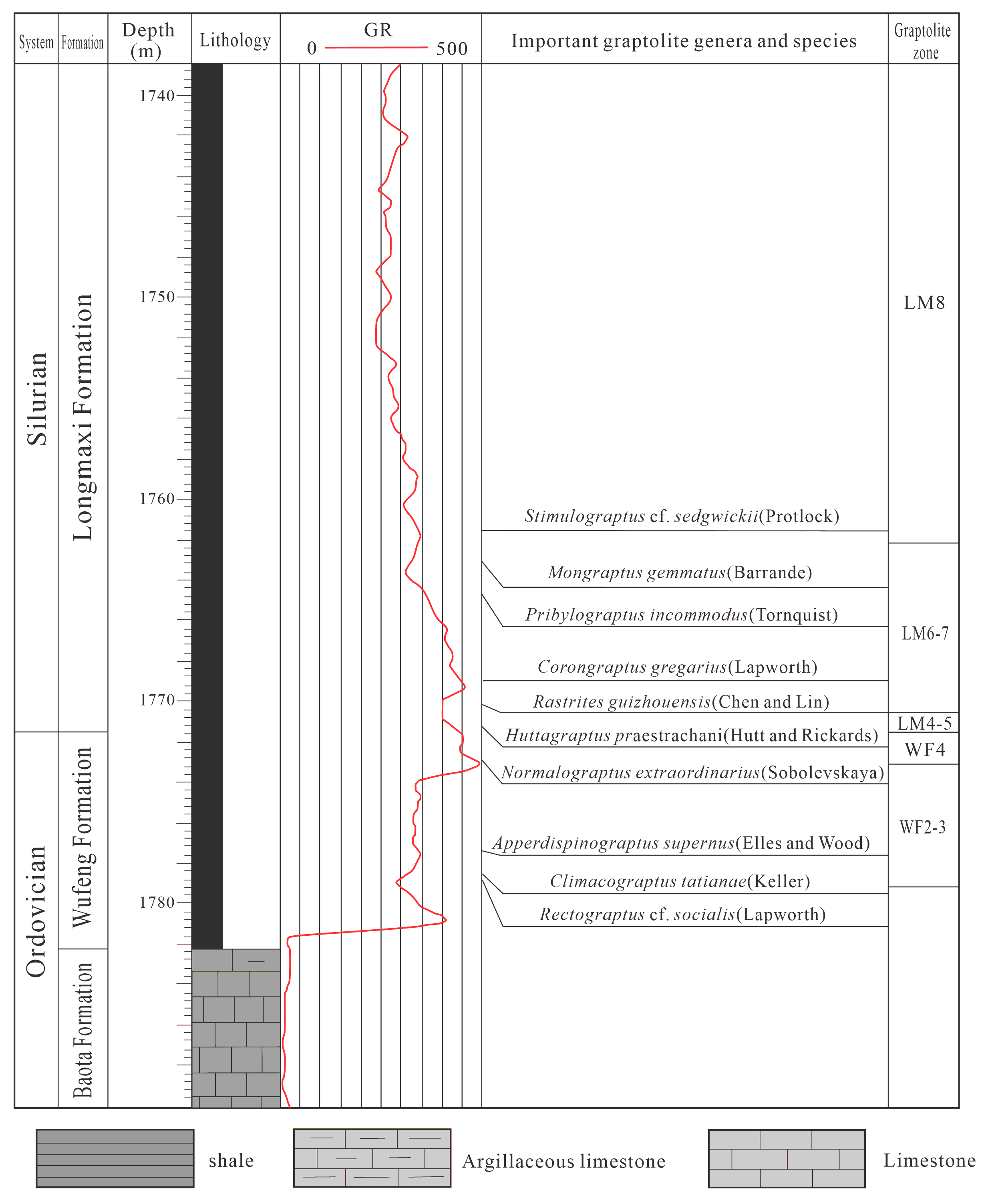
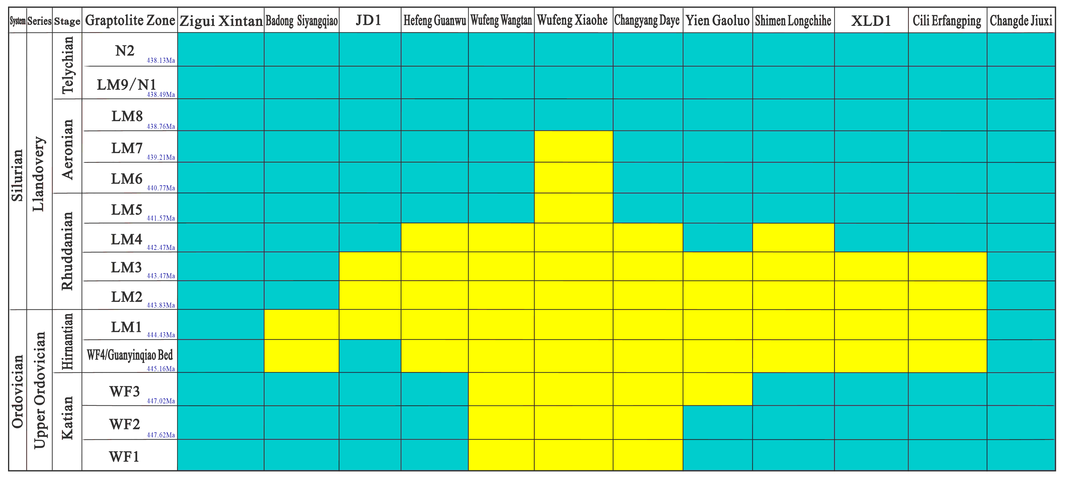
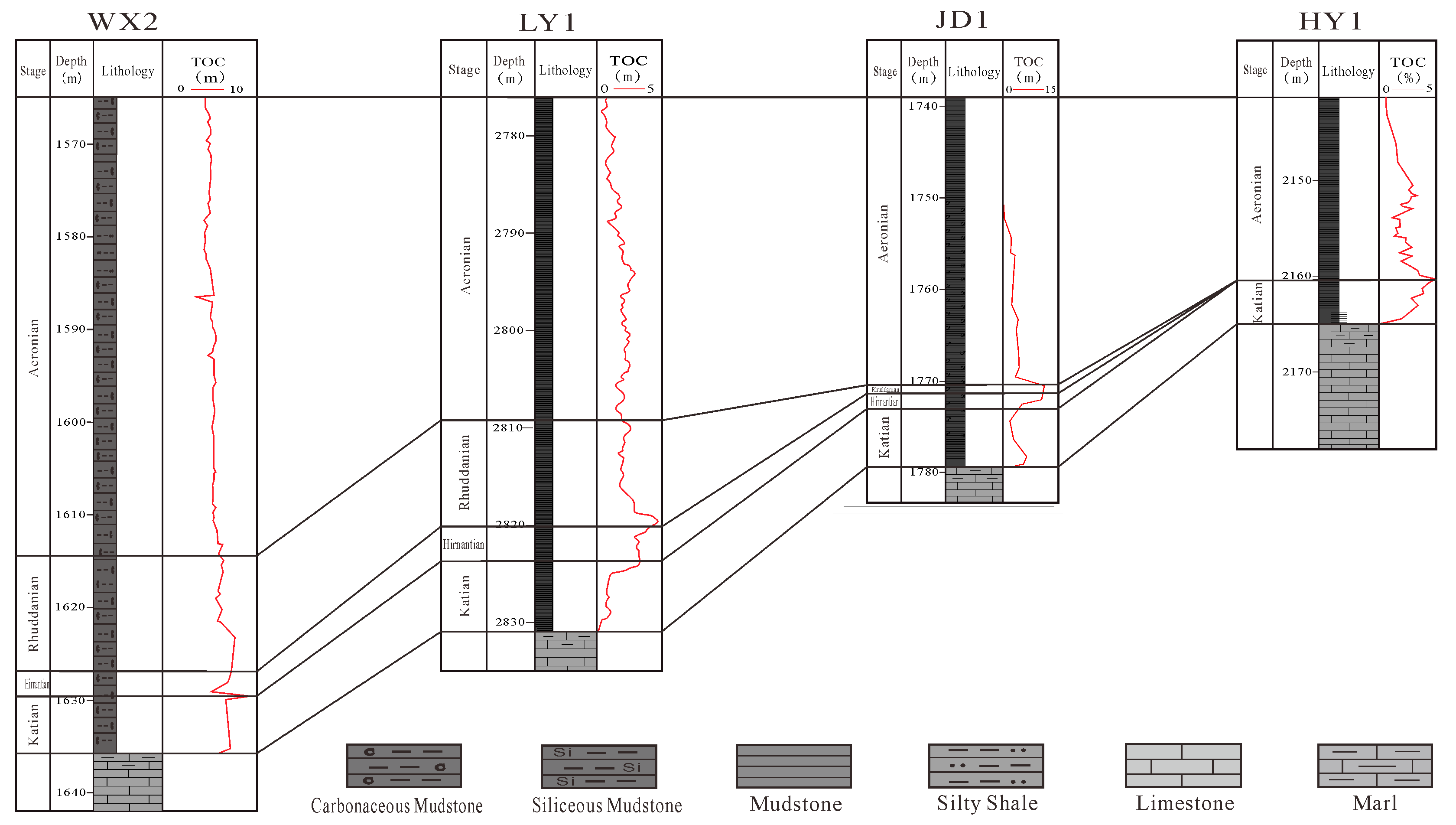
4.1. Graptolite Shale Stratigraphy Correlation

Through the observation and description of the core of Well JD1, the author believes that the well contains a total of eight graptolite zones from the Dicellograptus complexus of the Ordovician Katian Stage to the Stimulograptus sedg-wickii of the Silurian Aeronian Stage, and three graptolite zones of Perculptogr.Perculptus, Akidograptus ascensus and Parakido gr.acuminatus are missing. Among them, the Wufeng Formation is well developed, and there is no definite graptolite evidence for the WF1 zone, which may be due to the phase transition relationship between the WF1 zone in the Yangtze region and the underlying Dabaota Formation. Although no fossils from the WF2-WF3 zones were found in the well, important molecules were discovered in it. A rare WF4 zone fossil, Normalograptus extraordinarus (Sobolevskaya), was discovered in the well, indicating that the base of the Hernantian Stage can be defined in Well JD1 (Figure 2). From Guanyinqiao bed to LM3 zone, there is a gap, but Huttagraptus praestrachani (Hutt and Rickards) and other graptolites were found at a depth of 1771.30 m. This species is found in European strata corresponding to LM4 and above. Therefore, it is speculated that LM4 zone exists in Well JD1, but no graptolite characteristics of the LM5 zone were found. Based on the stratigraphic relationship between upper and lower, it is presumed that the LM5 zone may be present. Starting from a depth of 1770.30 m, a Rastrites guizhouensis Chen and Lin graptolite fauna appeared, confirming the presence of the LM6 zone; this fauna can extend upwards into the LM7 zone. Stimulograptus cf.sedgwickii (Portlock) appeared from 1761.90 m, which is the zone fossil of the LM8 zone, confirming the presence of the basal strata of the LM8 zone in Well JD1. Based on the identification of graptolite fossils in the black shale of the Wufeng Formation–Longmaxi Formation, the graptolite stratigraphy of this well is divided as shown in Figure 2. Since the precise first occurrence of each graptolite zone could not be accurately determined, the exact base of each graptolite zone may be slightly lower than the positions indicated in the figure.
Based on the graptolite stratigraphy division of Well JD 1 and combined with the GBDB online database (Geobiodiversity Database), with the graptolite shale stratigraphy division and correlation standard as a gauge, the graptolite shale sequences of 23 outcrop points and 11 wells in the Western Hunan–Hubei region, which cross the Ordovician–Silurian boundary, were compared for the Wufeng Formation and Longmaxi Formation profiles. The comparison results show that the graptolite zones in the black shale of the Wufeng Formation and Longmaxi Formation in the Western Hunan–Hubei region are missing to varying degrees. Complete development occurs only in localized areas such as Lichuan, Xianfeng, Zigui in Hubei, and Jiuxi in Changde, Hunan. In most areas, at least two graptolite zones (WF2-LM4) are generally absent (Figure 3 and Figure 4). The graptolite zones are most extensively missing in the Xiaohe Village area of Wufeng, Hubei, where eleven graptolite zones from WF1 to LM7 are absent. The LM8 zone and above strata directly overlie the Ordovician Baota Formation. The number of missing graptolite zones is relatively severe in areas such as WanTan in Wufeng and Dayan in Changyang, Hubei, where the eight graptolite zones from WF1 to LM4 are generally absent. The LM5 zone and above strata directly overlie the Ordovician Baota Formation. In other areas, such as Jianshi, Badong, Hefeng, Yien, Shimen in Hubei, and Longshan in Hunan, there are also varying degrees of absence of graptolite zones in the Wufeng Formation and Longmaxi Formation. Generally, at least two graptolite zones from WF4 to LM4 are missing (Figure 3). The comparison results confirm that a submarine uplift developed in most areas of Western Hunan Hubei area, which causes the shallowness of the ancient water body and means the sediment is difficult to preserve effectively, and there is a disconformable contact between the black shale of the Wufeng Formation and Longmaxi Formation, with obvious sedimentary hiatus.

4.2. The Range of the Xiang-E Submarine Uplifts

The outcrop points and drilling data across the boundary between the Ordovician and the Silurian in the Western Hunan–Hubei region show that there is a common sedimentary hiatus between the black shales of the Wufeng Formation and Longmaxi Formation in the areas such as Taiyanghe in Enshi, Wantan in Wufeng, Hubei and Longchihe in Shimen, Hunan [25,26,27,28]. Mr. Sun Yunzhu first called this sedimentary hiatus “Yichang Uplift” [27]. Affected by the “Yichang Uplift”, the Xiang-E submarine uplift was developed at the border of Hubei and Hunan [15,16]. By comparing the shale graptolite sequences of the Wufeng Formation and Longmaxi Formation (Figure 4), the distribution range of the Xiang-E submarine uplifts at the Ordovician–Silurian transition (Katian Age to Rhuddanian Age) can be roughly delineated (Figure 5). Among them, the purple line delimits an area where the Wufeng Formation is generally missing, and the LM5 zone and above directly cover the Ordovician Baota Formation. It reflects the range of the submarine uplifts during the early sedimentation of the Wufeng Formation (WF1-WF3 zone sedimentation period); the green line delimits an area where the LM4 zone and above directly cover the WF3 zone, and the WF4-LM3 zone strata are generally missing. It reflects the range of the submarine uplifts in the early Hirnantian Age (WF4 zone sedimentation period); the red line delimits an area where the Guanyinqiao Bed-LM2 zone strata are generally missing, and the Silurian Longmaxi Formation LM3 zone and above directly cover the WF3 zone. It reflects the range of the submarine uplifts during the middle–late Hirnantian Age to the early Rhuddanian Age (Guanyinqiao Bed-LM2 zone sedimentation period); the blue line delimits an area where the WF4-LM4 zone strata are generally missing, and the LM5 zone and above directly cover the WF3 zone. It reflects the range of the submarine uplifts in the middle Rhuddanian Age (LM3-LM4 zone sedimentation period).

4.3. Evolution Model of the Submarine Uplifts

By delimiting the range in different periods, the activity status and its evolution mode of the Xiang-E submarine uplifts at the Ordovician–Silurian transition can be understood. The formation of the Xiang-E submarine uplifts may have initially begun at the end of the Baota Formation deposition and ultimately ended at the beginning of the Coronograptus gregarius graptolite zone [11,29,30]. During the Katian Age, the Xiang-E submarine uplift was mainly limited to the local areas such as Xiaohe Village, Shaziya, Wantan and Xiejiafan in Wufeng, Hubei, with the smallest range. Affected by the submarine uplifts, the water body in the above areas became shallower, leading to the general absence of the WF1-WF3 graptolite zone shale (the area enclosed by the purple line in Figure 4). In the early Hennantian Age (WF4 zone sedimentation period), the WF4 zone was generally absent in most areas of the Western Hunan–Hubei region, such as Sanbaoling in Laifeng, the Sunyang River in Enshi, Siyangqiao in Badong, Hubei and Wentang in Zhangjiajie, and Erfangping in Cili, Hunan (the area enclosed by the green line in Figure 4). During this time, the range of the Xiang-E submarine uplifts expanded significantly. By the middle of the Hennantian Age (Guanyingqiao bed sedimentation period), the influence of the Xiang-E submarine uplift reached its maximum extent, causing the widespread absence of the Guanyinqiao bed in areas such as Longping in Jianshi (JD 1 well), Wufeng, Gaoluo in Yien, Taiyanghe in Enshi, Hubei, as well as Longchihe in shimen, Wentang in Zhangjiajie, and Erfangping in Cili, Hunan, covering most of the Western Hunan–Hubei area (the area enclosed by the red line in Figure 4). The core areas of the uplifts (local areas of Wufeng) even emerged above the water and experienced weathering and erosion [31,32,33]. From the late Hennantian Age to the early Rhuddanian Age (LM1-LM2 zone sedimentation period), the range of Xiang-E submarine uplifts was basically the same as that in the middle Hennantian Age, with most areas lacking the LM1 and LM2 zone. During the middle–late Rhuddanian Age and thereafter, the Xiang-E submarine uplifts gradually retracted inward. Except for local areas such as Guanwu in Hefeng, Wufeng, Changyang in Hubei, and Longchihe in Shimen, Hunan, where at least one graptolite zone of the LM4 or LM5 is absent (the area enclosed by the blue line in Figure 4), the strata are developed in other areas.
In summary, it can be seen that during the Ordovician–Silurian transition (from the Katian Age to the Rhuddanian Age), the Xiang-E submarine uplifts as a whole exhibited an evolutionary pattern of continuous uplift from the Katian Age to the early Rhuddanian Age, with an expanding influence range, followed by a gradual retraction during the middle–late Rhuddanian Age.

4.4. The Evolution Mechanism of Submarine Uplifts

The formation of the Xiang-E submarine uplifts may have originated from the Guangxi movement. The “HuaXia ancient land” continued to expand westward and northwestward during the late Ordovician Sandbian Age, generating a horizontal force from east to west [11,33,34], breaking the relatively stable paleogeographic pattern of shallow carbonate platform of the Yangtze block [27,29,30,35], and locally uplifting to form an submarine paleogeographic uplifts in the Western Hubei–Hunan region. Moreover, with the enhancement of the tectonic compression from the Guangxi movement, the passive continental margin of the Yangtze block began to transform into a foreland basin [36,37,38,39], and the Xiang-E submarine uplifts, as the forebulge of the foreland basin, continued to uplift (Figure 5), causing the shallowing of the ancient water body, the difficulty of effective preservation of sediments and stratum loss.
The range of the Xiang-E submarine uplifts was also affected by polar glacier condensation and melting at the Ordovician–Silurian transition, leading to a cyclical variation in global sea levels [40], characterized by rise, fall, and rebound (Figure 5). During the Katian Age, influenced by the Boda warming event [41,42], the Western Hunan–Hubei region was in the early stage of rapid sea-level rise. However, from the widespread absence of the WF1–WF3 graptolite zone shales in the area of Wufeng, Hubei (Figure 5), it can be seen that the amplitude of sea-level rise in this period was less than the uplift amplitude of the submarine uplifts. In the early–middle Hernantian Age, the global climate sharply cooled, and the glacier of the polar Gondwana continent condensed and expanded on a large scale [43,44]. A large-scale marine regression and global sea-level fall occurred in the Yangtze region [45,46], and the influence range of the Xiang-E submarine uplifts gradually expanded (Figure 4 and Figure 5), reaching its maximum in the middle Hennantian Age. From the late Hennantian to the middle and late Rhuddanian, the paleoclimate warmed rapidly, the Gondwana glaciers quickly melted, and sea levels rose significantly. The influence range of the Xiang-E submarine uplifts showed a gradual contraction pattern (Figure 4 and Figure 5). Unlike the paleo-uplift evolution pattern of the Appalachian Basin in North America [47], the rate of sea-level rise in the Western Hunan–Hubei region is greater than the rate of regional tectonic uplift. The expansion and contraction of the range of the Xiang-E submarine uplifts from the Hennantian to the middle and late Rhuddanian is consistent with the cyclical changes of the global sea-level rise and fall caused by the condensation and melting of the glacier (Figure 5).
Figure 5. Evolutionary model schematic diagram of the Xiang-E submarine high at the Ordovician–Silurian transition (the sea-level fluctuation curve is cited from References [48,49,50,51,52,53]).
Jmse 13 00739 g005
There is still controversy regarding whether the absence of the black shale graptolite zones in the Wufeng Formation and Longmaxi Formation is due to sedimentary hiatus or erosional removal. The evolutionary model of the Hubei–Hunan underwater highland established in this study has certain limitations. Overall, the evolutionary mechanism of the Xiang-E submarine uplifts is jointly controlled by the Guangxi movement and the global sea-level rise and fall cycles caused by the condensation and melting of polar glaciers. Its initial form originated from the Guangxi movement, while the global sea-level variation caused by the condensation and melting of polar glaciers is the primary controlling factor for the changes in the influence range of the Xiang-E submarine uplifts. Affected by this, within the range of the Xiang-E submarine uplifts, at least two graptolite zone organic-rich shales of WF2-LM4 in the Wufeng Formation and Longmaxi Formation are generally absent.

4.5. Influence on Shale Gas Accumulation

Shale gas exploration and development in the Sichuan Basin and its surrounding areas have revealed that the shale within the WF2-LM4 graptolite zone is the core interval for Silurian shale gas exploration and development in southern China. At present, approximately 30 wells have been drilled into the Wufeng Formation–Longmaxi Formation in the Western Hunan–Hubei area, but the gas content of the shale varies greatly (Table 1). It shows that the wells with good drilling results are basically distributed outside the range of the Xiang-E submarine uplifts (the area enclosed by the red line in Figure 6). The gas content of the shale within the uplifts range is generally poor (with a maximum total gas content of not more than 2 m3/t), and the closer to the core part of the uplifts, the thinner the thickness of the organic-rich shale (Figure 6), and the poorer the gas content. The main reason may be the widespread absence of organic-rich shale in the WF2-LM4 graptolite zone within the Xiang-E submarine uplifts.
Previous studies have made an in-depth analysis of the formation environment and reservoir development characteristics of the different graptolite zones of the Wufeng and Longmaxi formations. It is generally believed that the shale in the WF2-LM4 graptolite zone is characterized by low sedimentation rate, good organic matter type and high organic matter abundance. The reservoir pore type of the shale is mainly organic matter pore and supplemented by inorganic pore. Natural gas is mainly in an adsorbed state and supplemented by a free state [54,55]. However, the shales of LM5 and above the graptolite zone have low organic matter abundance, and the reservoir is mainly composed of mineral pores, supplemented by organic pores [56,57]. Correspondingly, shale gas is primarily present in a free state and supplemented by an adsorbed state [13,22,55]. Under the same degree of tectonic modification, shale gas reservoirs dominated by the adsorbed state are often more resistant to damage than shale gas reservoirs dominated by the free state [57]. For example, in Well XD2 and Well SY1 (well locations shown in Figure 6), under the condition of similar burial depth of the target layer, the shale gas content of the Wufeng Formation–Longmaxi Formation in the two wells is quite different, which may be related to the absence of organic-rich shale in the WF4-LM4 graptolite zone in Well SY1 (Table 1).
In summary, at the Ordovician–Silurian transition, controlled by the dual effects of the Guangxi movement and global sea level changes caused by polar glacier condensation and melting, at least two graptolite zone shales of WF2-LM4 are generally absent in the Xiang-E submarine uplifts developed at the border of Hubei and Hunan, resulting in poor material basis for shale gas accumulation and hydrocarbon generation within the range of the submarine uplifts. The black shales of the WF2-LM4 graptolite zone in the Wufeng Formation–Longmaxi Formation are well developed in areas such as Xianfeng, Lichuan, Yichang in Hubei, and Wushan in Chongqing, with good potential for shale gas exploration and development.

5. Conclusions

(1)
The results of graptolite stratigraphic correlation of wells and outcrop sections in the Western Hunan–Hubei region confirmed the development of the Xiang-E submarine uplifts during the Ordovician–Silurian transition. It shows an evolutionary pattern of continuous uplift from the Katian Age to the early Rhuddanian Age, with a gradually expanding influence range, followed by a gradual shrinkage during the middle to late Rhuddanian Age. The initial form of the Xiang-E submarine uplift may have originated from the Guangxi movement, and the global sea-level rise and fall cycles caused by the condensation and melting of polar glaciers are the primary controlling factors for the changes in the influence range of the Xiang-E submarine uplifts.
(2)
Within the range of the Xiang-E submarine uplifts, at least two graptolite zone organic-rich shales of WF2-LM4 in the Wufeng Formation and Longmaxi Formation are generally absent, resulting in poor material basis for shale gas accumulation and hydrocarbon generation and a higher exploration risk. However, the Silurian strata in areas such as Xianfeng, Lichuan, Yichang in Hubei, and Wushan in Chongqing have good potential for shale gas exploration and development. The research findings can provide important references for shale gas area evaluation and the next steps of exploration deployment in southern China.
(3)
This study, based on data from 23 outcrop points and 11 wells in the Western Hunan–Hubei region, investigates the range and evolution model of the Xiang-E submarine uplifts. The data coverage is limited and primarily relies on the black shale graptolite stratigraphy correlation. Future work should focus on strengthening the sampling of drillings and outcrop points, as well as expanding the geographical coverage. This will further elucidate the spatial distribution and subsurface structural characteristics of the Xiang-E submarine uplifts and enhance the precision of its characterization. Integrate high-precision 3D seismic data with geochemical tracing to deepen the study of uplift-controlled hydrocarbon accumulation mechanisms.

Author Contributions

The overall concept of this paper was proposed by Z.Z., who was also responsible for establishing the paleontological stratigraphic framework of the Wufeng Formation–Longmaxi Formation in Well JD1 and the evolution model of the submarine uplifts in the Xiang-E area. H.Z. was responsible for comparing the paleontological stratigraphic frameworks of the Wufeng Formation–Longmaxi Formation in the Xiang-E West area and delineating the extent of the Xiang-E submarine uplifts during the Ordovician–Silurian transition. Z.J. guided the overall concept of the paper and participated in the establishment of the evolution model of the Xiang-E submarine uplifts and its impact on shale gas enrichment and accumulation. S.L. was responsible for studying the impact of the Xiang-E submarine uplifts on the conditions for shale gas enrichment and accumulation. S.B. guided and participated in the establishment of the evolution model of the Xiang-E submarine uplifts and its impact on shale gas enrichment and accumulation. G.X. participated in the study of the impact of the Xiang-E submarine uplifts on the conditions for shale gas enrichment and accumulation and completed the comparative analysis of relevant shale gas drilling data. All authors have read and agreed to the published version of the manuscript.

Funding

This research was funded by National Science and Technology Major Project ‘Research on Shale Gas Resource Evaluation Methods and Exploration Techniques’ grant number 2016ZX05034001-001, the China Geological Survey project ‘Investigation and evaluation of shale gas in key basins’ grant number DD20230023 and Cooperative Technology Development Projects of PipeChina ‘Research on Site Selection Evaluation of Aquifer Gas Storage and Supporting Policies for Construction’ grant number GWHT20240022569.

Data Availability Statement

The data presented in this study are available on request from the corresponding author due to commercial confidentiality.

Conflicts of Interest

Guihong Xu was employed by Beijing CAS Geophysical Energy Technology Co., Ltd. The remaining authors declare that the research was conducted in the absence of any commercial or financial relationships that could be construed as a potential conflict of interest.

References

  1. Guo, T.L.; Zhang, H.Y. Formation and enrichment mode of Jiaoshiba shale gas field, Sichuan Basin. Pet. Explor. Dev. 2014, 41, 28–36. [Google Scholar] [CrossRef]
  2. Zou, C.N.; Dong, D.Z.; Wang, Y.M.; Li, X.J.; Huang, J.L.; Wang, S.F.; Guan, Q.Z.; Zhang, C.C.; Wang, H.Y.; Liu, H.L.; et al. Shale gas in China: Characteristics, Challenges and Prospects(I). Pet. Explor. Dev. 2015, 42, 689–701. [Google Scholar] [CrossRef]
  3. Zhao, W.Z.; Li, J.Z.; Yang, T.; Yang, T.; Wang, S.F.; Huang, J.L. Geological difference and its significance of marine Shale Gases in South China. Pet. Explor. Dev. 2016, 43, 499–510. [Google Scholar] [CrossRef]
  4. Dong, D.Z.; Shi, Z.S.; Guan, Q.Z.; Jiang, S.; Zhang, M.Q.; Zhang, C.C.; Wang, S.Y.; Sun, S.S.; Yu, R.Z.; Liu, D.X.; et al. Progress, challenges and prospects of shale gas exploration in the Wufeng–Longmaxi reservoirs in the Sichuan Basin. Nat. Gas Ind. 2018, 38, 67–76. [Google Scholar] [CrossRef]
  5. Jin, Z.J.; Hu, Z.Q.; Gao, B.; Zhao, J.H. Shale Gas enrichment and high yield control factors of the Wufeng Formation—Longmaxi Formation in Southeastern Sichuan. Earth Sci. Front. 2016, 23, 1–10. [Google Scholar]
  6. Guo, X.S.; Hu, D.F.; Li, Y.P.; Wei, Z.H.; Wei, X.F.; Liu, Z.J. Geological factors controlling shale gas enrichment and high production in Fuling shale gas field. Pet. Explor. Dev. 2017, 44, 481–491. [Google Scholar] [CrossRef]
  7. Ma, X.H.; Xie, J. The progress and prospects of shale gas exploration and exploitation in southern Sichuan Basin, NW China. Pet. Explor. Dev. 2018, 45, 161–169. [Google Scholar] [CrossRef]
  8. Wang, J.; Bao, H.Y.; Lu, Y.Q.; Liu, J.; Zhang, M.Y. Quantitative characteristics and main controlling factors of shale gas Occurrence in Jiaoshiba, Fuling. Earth Sci. 2018, 44, 1001–1011. [Google Scholar]
  9. Chen, X.; Fan, J.X.; Zhang, Y.D.; Wang, H.Y.; Chen, Q.; Wang, W.H.; Liang, F.; Guo, W.; Zhao, Q.; Nie, H.K.; et al. Division and Delineation of Black Shale in Yangtze coverage Area of Wufeng Formation and Longmaxi Formation. J. Stratigr. 2015, 39, 351–358. [Google Scholar]
  10. Zou, C.N.; Gong, J.M.; Wang, H.Y.; Shi, Z.S. Importance of Graptolite Evolution and Biostratigraphic Calibration on Shale Gas Exploration. China Pet. Explor. 2019, 24, 1–6. [Google Scholar] [CrossRef]
  11. Chen, X.; Rong, J.Y.; Zhou, Z.Y.; Zhang, Y.D.; Zhan, R.B.; Liu, J.B.; Fan, J.X. The Central Guizhou and Yichang Uplifts, Upper Yangtze region, between Ordovcian and Silurian. Chin. Sci. Bull. 2001, 46, 1052–1056. [Google Scholar]
  12. Rong, J.Y.; Chen, X.; Wang, Y.; Zhan, R.B.; Liu, J.B.; Huang, B.; Tang, P.; Wu, R.C.; Wang, G.X. Transition of the central guizhou continent at the turn of the ordovician and Silurian: Evidence and revelation. Sci. China Earth Sci. 2011, 41, 1407–1415. [Google Scholar]
  13. Nie, H.K.; Jin, Z.J.; Bian, R.K.; Du, W. The accumulation of Shale Gas “Source cap controlled Reservoir” in the Wufeng Formation of the Upper Ordovician and the Longmaxi Formation of the lower Silurian. J. Oil 2016, 37, 557–571. [Google Scholar] [CrossRef]
  14. Sun, Y.C. Bases of the chronological classification with special reference to the Palaeozoic stratigraphy of China. Bull. Geol. Soc. China 1943, 23, 35–56. [Google Scholar] [CrossRef]
  15. Chen, X.; Rong, J.Y.; Li, Y.; Yue, L.; Boucot, A.J. Facies patterns and geography of the Yangtze region, South China, through the Ordovician and Silurian transition. Palaeogeogr. Palaeoclim. Palaeoecol. 2004, 204, 353–372. [Google Scholar]
  16. Fan, J.X.; Michael, J.M.; Chen, X.; Wang, Y.; Zhang, Y.D.; Chen, Q.; Chi, Z.L.; Chen, F. Biostratigrapand geography of the Ordovicim-Silurim Luugmacbi black sbales in South China. Sci. China Earth Sci. 2012, 42, 130–139. [Google Scholar]
  17. Zhou, Z.; Zhai, G.Y.; Shi, D.S.; Wang, S.J.; Guo, T.X.; Liu, Y.M.; Wang, H. Shale Gas Reservoir Geology of the Upper Ordovician Wufeng Formation-Lower Silurian Longmaxi Formation in western Hubei and northeastern Chongqing. Pet. Geol. Exp. 2019, 41, 1–9. [Google Scholar]
  18. Feng, Z.Z.; Peng, Y.M.; Jin, Z.K.; Jiang, P.L.; Bao, Z.D.; Luo, Z.; Ju, T.Y.; Tian, H.Q.; Wang, H. Lithofacies Paleogeography of the Middle and Late Ordovician in South China. J. Paleogeography 2001, 10–24+96–99. [Google Scholar]
  19. Lu, Y.B.; Ma, Y.Q.; Wang, Y.X.; Wang, Y.X.; Lu, Y.C. The sedimentary response to the major geological events and lithofacies characteristics of Wufeng Formation-Longmaxi Formation in the Upper Yangtez area. Earth Sci. 2017, 42, 1169–1184. [Google Scholar]
  20. Zhou, X.F.; Guo, W.; Li, X.Z.; Zhang, X.W.; Liang, P.P.; Yu, J.M. Mutual relation between organic matter types and pores with petro logical evidence of radiolarian siliceous shale in Wufeng Longmaxi Formation, Sichuan Basin. J. China Univ. Pet. (Ed. Nat. Sci.) 2022, 46, 12–22. [Google Scholar]
  21. Su, W.B.; Huff, W.D.; Ettensohn, F.R.; Liu, X.M.; Zhang, J.E.; Li, Z.M. K-bentonite, black-shale and flysch successions at the Ordovician-Silurian transition, South China: Possible sedimentary responses to the accretion of Cathaysia to the Yangtze block and its implications for The evolution of Gondwana. Gondwana Res. 2009, 15, 111–130. [Google Scholar] [CrossRef]
  22. Wang, C.; Zhang, B.Q.; Shu, Z.G.; Lu, Y.Q.; Bao, H.Y.; Yang, W.X.; Liu, C.; Li, K. Shale Lamination and Its influence on Shale Reservoir Quality of Wufeng Formation—Longmaxi Formation in Jiaoshiba Area. Earth Sci. 2019, 44, 972–982. [Google Scholar]
  23. Qiu, Z.; Zou, C.N. Unconventional petroleum sedimentology: Connotation and prospect. Acta Sedimentol. Sin. 2020, 38, 129. [Google Scholar]
  24. Gradstein, F.M.; Ogg, J.G.; Schmitz, M.D.; Ogg, G.M. On the Geologic Time Scale; Elsevier: Amsterdam, The Netherland, 2012. [Google Scholar] [CrossRef]
  25. Zhou, X.J.; Yang, F. Tectonic-Palaeogeographic Evolution of the South China Continent during the Late Caledonian. Pet. Geol. Exp. 2009, 31, 128–135+141. [Google Scholar]
  26. Wang, C.S.; Wang, X.F.; Wei, K.; Zeng, X.W.; Wang, J.P.; Li, Y.G. The Silurian Sea Level Changes and Sequence Stratigraphic Division and Correlation in Western Hunan and Hubei Provinces. South China Geol. 2022, 38, 67–78. [Google Scholar]
  27. Chen, X.; Chen, Q.; Zhen, Y.Y.; Wang, H.Y.; Zhang, L.N.; Zhang, J.P.; Wang, W.H.; Xiao, Z.H. Circumjacent distribution pattern of the Lungmachian graptolitic black shale (early Silurian) on the Yichang Uplift and its peripheral region. Sci. China Earth Sci. 2018, 61, 1195–1203. [Google Scholar] [CrossRef]
  28. Rong, J.Y.; Wang, Y.; Zhan, R.B.; Fan, J.X.; Huang, B.; Tang, P.; Li, Y.; Zhang, X.L.; Wu, R.C.; Wang, G.X.; et al. Silurian integrative stratigraphy and timescale of China. Sci. China Earth Sci. 2019, 62, 89–111. [Google Scholar] [CrossRef]
  29. Zhang, G.W.; Guo, A.L.; Wang, Y.J.; Li, S.Z.; Dong, Y.P.; Liu, S.F.; He, D.F.; Cheng, S.Y.; Lu, R.K.; Yao, A.P. Tectonics of South China Continent and Its Implications. Sci. China Earth Sci. 2013, 56, 1804–1828. [Google Scholar] [CrossRef]
  30. Wang, X.; Gao, X.F.; Zha, X.F. Tectonic Response of the Kwangsian Orogeny in the Northern Margin of the South China Block: Evidences from Biostratigraphy. Earth Sci. 2024, 49, 3199–3211. [Google Scholar]
  31. Xu, Y.J.; Du, Y.S. From Periphery Collision to Intraplate Orogeny: Early Paleozoic Orogenesis in South- eastern Part of South China. Earth Sci. 2018, 43, 333353, (In Chinese with English Abstract). [Google Scholar]
  32. Wang, Y.; Rong, J.Y.; Zhan, R.B.; Huang, B.; Wu, R.C.; Wang, G.X. On the Ordovician-Silurian boundary Strata in Southwestern Hubei, and the Yichang Uplift. J. Stratigr. 2013, 37, 264–274. [Google Scholar]
  33. Wang, Y.; Rong, J.Y.; Tang, P.; Huang, B.; Zhang, X.L.; Xu, H.H.; Liu, F.; Jiang, Q.; Wang, Y. Characteristics of Major Hiatus in Middle Paleozoic Rocks of South China and Their Significance of Geotectonics. Sci. China (Ser. D) 2021, 51, 218–240. (In Chinese) [Google Scholar]
  34. Isozaki, Y.; Aoki, K.; Nakama, T.; Yanai, S. New Insight into a Subduction-Related Orogen: A Reappraisal of the Geotectonic Framework and Evolution of the Japanese Islands. Gondwana Res. 2010, 18, 82–105. [Google Scholar] [CrossRef]
  35. Rong, J.Y.; Zhan, R.B.; Xu, H.G.; Huang, B.; Yu, G.H. Expansion of the Cathaysian Oldland through the Ordovician-Silurian transition: Emerging evidence and possible dynamics. Sci. China Earth Sci. 2010, 53, 1–17. [Google Scholar] [CrossRef]
  36. Shu, L.S.; Yao, J.L.; Wang, B.; Faure, M.; Charvet, J.; Chen, Y. Neoproterozoic plate tectonic process and Phanerozoic geodynamic evolution of the South China block. Earth-Sci. Rev. 2021, 216, 103596. [Google Scholar]
  37. Li, L.M.; Lin, S.F.; Xing, G.F. Identification of ca. 520 Ma mid-ocean-ridge-type ophiolite suite in the inner Cathaysia block, South China: Evidence from shearing-type oceanic plagiogranite. Geol. Soc. Am. Bull. 2022, 134, 1701–1720. [Google Scholar] [CrossRef]
  38. Hou, M.C.; Qi, L.; Li, K.Z.; Li, L.; Ren, Q.; Zhao, Z.L.; Hu, S.P.; Hu, J.J.; Wang, Z.W. Characteristics and key scientific issues of the “atypical” Caledonian orogeny in South China. Acta Geol. Sin. 2024, 98, 3503–3529. [Google Scholar]
  39. Zhang, J.H.; Liu, W.L.; Yakymchuk, C.; Sa, R.N.; Zeng, Z.; Ding, R.X.; Tang, G.J.; Liu, H.Q.; Xu, Q.Y.; Wang, Y. Partial Melting and Crustal Deformation during the Early Paleozoic Wuyi-Yunkai Orogeny: Insights from Zircon U-Pb Geochronology and Structural Analysis of the Fuhuling Migmatites in the Yunkai Region, South China. Minerals 2019, 9, 621. [Google Scholar] [CrossRef]
  40. Yan, D.T.; Chen, D.Z.; Wang, Q.C.; Wang, J.G. Large-scale climatic fluctuations in the latest Ordovician on the Yangtze block, south China. Geology 2010, 38, 599–602. [Google Scholar] [CrossRef]
  41. Boucot, A.J.; Rong, J.Y.; Chen, X.; Scotese, C.R. Pre-Hirnantian Ashgill climatically warm event in the Mediterranean region. Lethaia 2003, 36, 119–131. [Google Scholar] [CrossRef]
  42. Fortey, R.A.; Covks, L.R. Late Ordovician global warming the Boda event. Geology 2005, 33, 405–408. [Google Scholar]
  43. Rong, J.Y.; Zhan, R.M. Ordovician-Silurian Brachiopod turnover in South China. Geoscience 1999, 13, 390–394. [Google Scholar]
  44. Ghienne, J.F. Late Ordovician sedimentary environments, glacial cycles, and post-glacial transgression in the Taoudeni Basin, West Africa. Palaeogeogr. Palaeoclim. Palaeoecol. 2003, 189, 117–145. [Google Scholar] [CrossRef]
  45. Brenchley, P.J.; Marshall, J.D.; Harper, D.A.T.; Buttler, C.J.; Underwood, C.J. A late Ordovician (Hirnantian) karstic surface in a submarine channel, recording glacio-eustatic sea-level changes: Meifod, central Wales. Geol. J. 2006, 41, 1–22. [Google Scholar]
  46. Finnegan, S.; Bergmann, K.; Eiler, J.M.; Jones, D.S.; Fike, D.A.; Eisenman, I.; Hughes, N.C.; Tripati, A.K.; Fischer, W.W. The magnitude and duration of Late Ordovician-Early Silurian glaciation. Science 2011, 331, 903–906. [Google Scholar] [CrossRef]
  47. Spotila, J.A.; Prince, P.S. Geomorphic complexity and the case for topographic rejuvenation of the Appalachian Mountains. Geomorphology 2022, 417, 108449. [Google Scholar] [CrossRef]
  48. Trotter, J.A.; Williams, I.S.; Barnes, C.R.; Lécuyer, C.; Nicoll, R.S. Did cooling oceans trigger Ordovician biodiversification? Evidence from conodont thermometry. Science 2008, 321, 550–554. [Google Scholar]
  49. Song, H.J.; Wignall, P.B.; Song, H.Y.; Dai, X.; Chu, D.L. Seawater temperature and dissolved oxygen over the past 500 million years. J. Earth Sci. 2019, 30, 236–243. [Google Scholar]
  50. Goldberg, S.L.; Present, T.M.; Finnegan, S.; Bergmann, K.D. A high-resolution record of early Paleozoic climate. Proc. Natl. Acad. Sci. USA 2021, 118, e2013083118. [Google Scholar]
  51. Sun, J.P.; Dong, Y.P.; Chen, Q.; Yang, L.; Li, W.H.; Zhang, D.D.; Zhang, Q. Ordovician Tectonic Transition from Passive Margin into Peripheral Foreland in the Southern Ordos: A Diagnostic Insight into the Closure of Erlangping Ocean between the North Qinling Arc and North China Block. Basin Res. 2023, 35, 336–362. [Google Scholar] [CrossRef]
  52. Meyer, K.M.; Kump, L.R. Oceanic euxinia in Earth history: Causes and consequences. Annu. Rev. Earth Planet. Sci. 2008, 36, 251–288. [Google Scholar] [CrossRef]
  53. Yang, X.R.; Yan, D.T.; Zhang, L.W.; Xu, H.W.; Liu, W.H.; Yun, J.L. The Genesis of Hirnantian Glaciation and Paleo-Ocean Environment During Ordovician-Silurian Transition. Acta Sedimentol. Sin. 2018, 36, 319–332. [Google Scholar]
  54. Nie, H.K.; Jin, Z.J.; Zhang, J.C. Characteristics of three organic matter pore types in the Wufeng-Longmaxi shale of the Sichuan Basin, Southwest China. Sci. Rep. 2018, 8, 7014. [Google Scholar] [CrossRef]
  55. Wang, Y.M.; Li, X.J.; Wang, H.; Jiang, S.; Chen, B.; Ma, J.; Dai, B. Developmental Characteristics and geological significance of the bentonite in the Upper Ordovician Wufeng-Lower Silurian Longmaxi Formation in eastern Sichuan Basin, SW China. Pet. Explor. Dev. 2019, 46, 653–665. [Google Scholar] [CrossRef]
  56. Yan, D.T.; Chen, D.Z.; Wang, Z.Z.; Li, J.; Yang, X.R.; Zhang, B. Climatic and oceanic controlled deposition of Late Ordovician-Early Silurian black shales on the North Yangtze platform, South China. Mar. Pet. Geol. 2019, 110, 112–121. [Google Scholar]
  57. Nie, H.K.; Wang, H.; He, Z.L.; Wang, Y.Y.; Zhang, P.X.; Peng, Y.M. Formation mechanism, distribution and exploration prospect of normal pressure Shale Gas reservoir:a case study of Wufeng Formation-Longmaxi Formation in Sichuan Basin and its periphery. J. Oil 2019, 40, 131–164. [Google Scholar] [CrossRef]
Figure 1. Regional tectonic location map of the study area. (a) Current tectonic architecture of South China Block (the red box indicates the location of the study area); (b) global paleogeographic map of the late Ordovician; (c) regional tectonic map of Western Hunan–Hubei Area.
Jmse 13 00739 g001
Figure 2. Graptolites zone division in Longmaxi and Wufeng Formations of Well JD1 in Northern Jianshi, Hubei.
Jmse 13 00739 g002
Figure 3. Comparison of the sequence of shale graptolite in Wufeng Formation and Longmaxi Formation of outcrop section and well in the western region of Hubei and Hunan (Note: Yellow indicates formation missing). Remarks: The isotopic age values of the base boundaries of each zone are from Gradstein et al. (2012) [24].
Jmse 13 00739 g003
Figure 4. The range of Xiang-E submarine uplift from latest Ordovician to earliest Silurian. Section point fossil data from Geobiodiversity Database. Section point: 1. Badong, Hubei Province, along the river; 2. Taiyang River in Enshi, Hubei Province; 3. Siyang Bridge, Badong, Hubei Province; 4. Xintan, Zigui, Hubei; 5. Huanghuachang, Yichang, Hubei; 6. Wangjiawan, Yichang, Hubei; 7. Dayan, Changyang, Hubei; 8. Wufeng Xiaohe Village; 9. Hubei Wufeng Shaziya; 10. Panjiawan, Yidu, Hubei; 11. Hubei Wufeng Lime Factory; 12. Wufeng Qiaohe River, Hubei Province; 13. Wufengwan Lake, Hubei; 14. Wufeng Jiaoping, Hubei; 15. Longchi River, Shimen, Hunan; 16. Xizhai, Jingzhou, Hubei; 17. Hubei Hefeng official house; 18. Hubei Xuan en Gaoluo; 19. Sanbao Ridge, Laifeng, Hubei; 20. Hubei Xianfeng dry river ditch; 21. Wentang, Zhangjiajie, Hunan 22. Hunan Cili Erfangping; 23. Jiuxi, Changde, Hunan.
Jmse 13 00739 g004
Figure 6. Across profile of the upper Ordovician Wufeng Formation–Lower Silurian Longmaxi Formation of wells WX2-LY1-JD1-HY1 in western Hubei and northeastern Chongqing.
Jmse 13 00739 g006
Table 1. Statistical table of stratigraphic characteristics and shale gas display in Wufeng and Longmaxi Formation in the western region of Hunan and Hubei Provinces.
NumWell NameStructural TypeStratigraphic Development CharacteristicsBase Depth (m) Thickness of Shale with TOC > 2.0% (m)Shale Gas Shows/Indications
1EYY2Monoclinal structureWF2-LM4 zone is fully developed2722.021.0Daily gas production from horizontal well: 3.15 × 10⁴ m3
2XD2Residual synclineWF2-LM4 zone is fully developed1520.028.0Field desorption gas content: maximum 3.5 m3/t; average 2.56 m3/t (28 samples)
3EZY1Monoclinal structureWF2-LM4 zone is fully developed2060.020.4Field desorption gas content: maximum 4.2 m3/t; average 3.0 m3/t (20 samples)
4SY1Monoclinal structureAbsence of WF4-LM4 zones1595.012.0Field desorption gas content: average 0.1 m3/t
5JD1AnticlineAbsence of LM1-LM3 zones1782.324.5Field desorption gas content: maximum 0.92 m3/t
6HY1AnticlineAbsence of WF4-LM4 zones2165.012.6Log-interpreted gas content: maximum 1.4 m3/t
7LD1Residual synclineAbsence of WF3-LM3 zones948.018.0Field desorption gas content: maximum 1.72 m3/t
8XLD1Residual synclineAbsence of WF3-LM3 zones1504.011.0Field desorption gas content: average 0.43 m3/t
9YY1Residual synclineAbsence of WF4-LM3 zones532.019.0Field desorption gas content: maximum 0.59 m3/t
Disclaimer/Publisher’s Note: The statements, opinions and data contained in all publications are solely those of the individual author(s) and contributor(s) and not of MDPI and/or the editor(s). MDPI and/or the editor(s) disclaim responsibility for any injury to people or property resulting from any ideas, methods, instructions or products referred to in the content.

