1. Introduction
Maritime transport activities shape a new type of economic sector considered as the blue economy [
1]. Since about 90% of the world’s merchandise are transported by sea [
2], maritime transport plays a central and potential role in economy nowadays. In parallel, safety requirements are continuously improved to avoid hazardous accidents and ensure a sustainable growth in maritime operations. According to the recent annual review of marine casualties and incidents in 2018 [
3] by the European maritime safety agency, more than 20,000 marine casualties and incidents have been reported at the European level in 2011–2017 only. Together, these accidents caused more than 680 fatalities and over 6800 injuries. Navigational accidents represent 53.1% of all casualties with ships as a combination of: grounding (16.6%), contact (16.3%) and collision (23.2%). Despite being slightly different, the rates of maritime navigation accidents are still tragically high according to marine casualty and pollution database collected by United States Coast Guard (USCG) and provided in July 2015 (not all 2014–2015 accidents reported) by marine information and safety and law reinforcement [
4]. In a total of 34,540 reported and fully investigated navigation accidents between 2000 and mid 2015, around 43.5% of the accidents were groundings, 39.6% were allisions with a static object and 16.9% were collisions as demonstrated in
Figure 1. A high-level risk analysis on passenger ship collisions presented in Reference [
5] suggested that risk control options related to navigation should be considered to reduce the overall risk of collision and that navigational aspects are important.
The consequences of maritime accidents can be fairly high as reported by transportation safety board of Canada [
6] where the provided data tables include the complete investigations into marine transportation occurrences in 2013–2019. From the reported 79,000 accidents, 80.8% caused damage, 9.86% caused a confirmed pollution, 7.99% caused minor injuries, 4.39% caused serious injuries, while 4.01% of the accidents caused fatalities. The reported accidents also occurred during various environmental conditions as depicted in
Figure 2, in which wind speed, visibility condition and sea state have weak effects as accident factors. A full literature review on research in maritime accidents is provided in Reference [
7] which lists different research methods and data sources in this context. To help reduce the occurrence rates of such accidents, qualitative research methods were deployed to understand the root causes such as maritime navigation risk indicators [
8] with explanatory variables such as vessel type as well as flag of convenience and visibility conditions, human and organizational factors [
9] and including decision errors due to conditions of operators and personnel factors and socio-technical factors [
10] such as the interactions between ship operators. The qualitative approach is however not very precise as
Figure 2 shows since most accidents occurred during good conditions. Moreover, taking into account the traffic densities during each condition and its frequencies, the correlations between sea/wind/visibility conditions and the numbers of accidents are very weak as found in Reference [
8]. Alternatively, the authors of Reference [
11] demonstrated that the general maritime safety approach is reactive and that accidents cannot be predicted. In real time, collision and grounding risk depends on the traffic configuration represented by the number of sailing vessels and their locations, relative speed and course to each other and to near objects and their maneuverability such as the stopping distance [
12] as well as the tactical diameter, maximum advance and track reach defined by the International Maritime Organization (IMO). These aspects are described in the following and they are incorporated in the design of the proposed risk identification method.
In addition to such severe impact of navigation accidents, the recent developments are continuously increasing the traffic capacity and leading to new emerging technologies and vessels characteristics. This consequently introduces new challenges for fast and early risk identification methods which are crucial to the safety and efficiency of maritime operations, especially in complex navigation situations. To avoid collision and grounding accidents and reduce their occurrence rates, automatic risk identification and analysis tools are receiving a growing attention in theoretical and practical applications. Decision support systems [
13] are vital in collision situations at sea and they are proved useful for collision avoidance and safety intervention [
14] or extended to intelligent route planning [
15] and autonomous navigation algorithms. These methods need to perceive all risky situations in their first stage which is very important for navigation safety. Risk identification was considered in Reference [
16] based on Automatic Identification System (AIS) data and the Closest Point of Approach (CPA) [
17] as well as distance at CPA and time to CPA parameters. These are typically based on assumptions of linear tracks, constant speed and course and neglect vessel dimensions and maneuverability. Another method for ship collision candidate detection was proposed in Reference [
18] based on a velocity obstacle approach. AIS information was also used for risk identification for vessel contact with fixed offshore platforms [
19]. Full reviews on individual ship-ship collision risk analysis and assessment are respectively given in Reference [
20,
21] where a considerable number of research items addressed individual collision risk detection and collision avoidance methods designed and validated using AIS data.
A critical shortcoming in the existing maritime navigation risk identification and evaluation methods is the neglection of vessel maneuverability which is a key factor that varies across different vessels and determines the risk in case of close-quarters situations. Moreover, the existing methods in the literature focus on individual risk while ignoring combinations of multiple collisions and ground situations and their interactions which limits the set of possible evasive actions and increase navigational complexity and confliction with navigation rules. In this work, a vessel maneuverability-based safety domain is designed within an adaptive framework based on navigation situations to identify both collision and grounding risk situations in a fast and computation-efficient approach. This algorithm is designed and validated through extensive amounts of AIS data (as it is the only sufficiently available data), hence the method is not considered as the basic risk identification tool. This was a worth-mentioning aspect for most AIS-based anti-collision methods published so far and it is supported by resolution A.1106(29) [
22] issued by IMO including guidelines on potential use of AIS but also its limits in this regard. Those guidelines recognize and recommend the use of AIS for anti-collision assistance but advise cautions that all safety-relevant information must be used and that AIS does not replace other systems. However, the implementation of this algorithm, with sufficient computational resources and access to online AIS information over a large monitored area, does not only detect but also identify navigation risk when available and yields a powerful tool for warnings and decision support, especially when multiple collisions and groundings situations starts developing. In addition, the implementation of this algorithm onboard vessels with access to information from all navigational systems will grant it an increased effectiveness. Compared to the existing methods in the literature, the actual navigation risk is introduced as a combination of interactions of multiple collision and/or grounding candidates. This work considers all types of navigation risk and their combinations over a large monitored area, the objective is to design and validate a computationally efficient algorithm for accurate and automatic risk identification from big historical AIS data. The successful identification of risky situations plays a leading role for decision support and smart navigation to assist the crew and avoid navigational hazards. Moreover, the analysis of huge historical data allows the extraction of a large set of risky situations with their probability of occurrence, this set is invaluable for simulating and verifying the trustworthiness of remote control and autonomous navigation functions.
The rest of this article is organized as follows,
Section 2 introduces the proposed method, starting from basic maneuverability aspects involved in the construction of a polygonal safety domain and its efficient approximation, followed by the designed collision and grounding spatial risk functions and the overall risk evaluation methods.
Section 3 then describes some data samples used for this application and the main results with a few examples and their discussions. This paper is then concluded in
Section 4 where important conclusions are drawn in addition to a summary of the major findings and potential applications of the presented method and suggestions for future work.
3. Applications and Discussion
The algorithms for identifying risky navigational situations outlined above have been applied to a large set of AIS data and have identified a number of challenging navigational situations accordingly. Some of the extracted situations will be described in the following examples.
3.1. Data Description and Set-up
The experimental validation data in this paper consists of two large sets of AIS data over a continuous full year as indicated in
Table 1.
AIS information from all vessels is interpolated and synchronized to 1 min in this work and all service vessels are ignored for risk identification. These include: Crew boats, pilot vessels, supply tenders, work and repair vessels, search and rescue vessels and salvage ships as well as mooring/towing/pushing/tugging vessels. These vessels are generally small and agile and are intended to perform their operations in contact with other bigger vessels so they are assumed neutral in this work.
Notice that, for simplicity, the time parameter was dropped in the previous risk functions as well as the actual collision, grounding and overall risk of each situation. In real applications, AIS data is first synchronized to similar time points at which the blocking area radii are updated as given by Equations (6) and (7) for each vessel () and their safety domains as in Equations (8)–(11) at each time . All safety domain violations are then identified for all relevant vessel to vessel (Equation (19)) and vessel to ground (Equation (26)) combinations. Collision risk CR is determined through Equations (21)–(25) and similarly the grounding risk (Equations (27)–(29)) and the situation risk by Equation (30).
The AIS data is interpolated and synchronized in this work to 1 min intervals
for
, where
is the most recent time vessel
sent AIS records before
and
is the first time after that. This equation applies to all dynamic navigation parameters in which
stands for either of {
,
,
,
} for each vessel
. Information about the vessel, such as its type and actual dimensions, are obtained from vessel registry. High-resolution digital maps are also used in the identification of grounding risk.
3.2. Obtained Results and Discussion
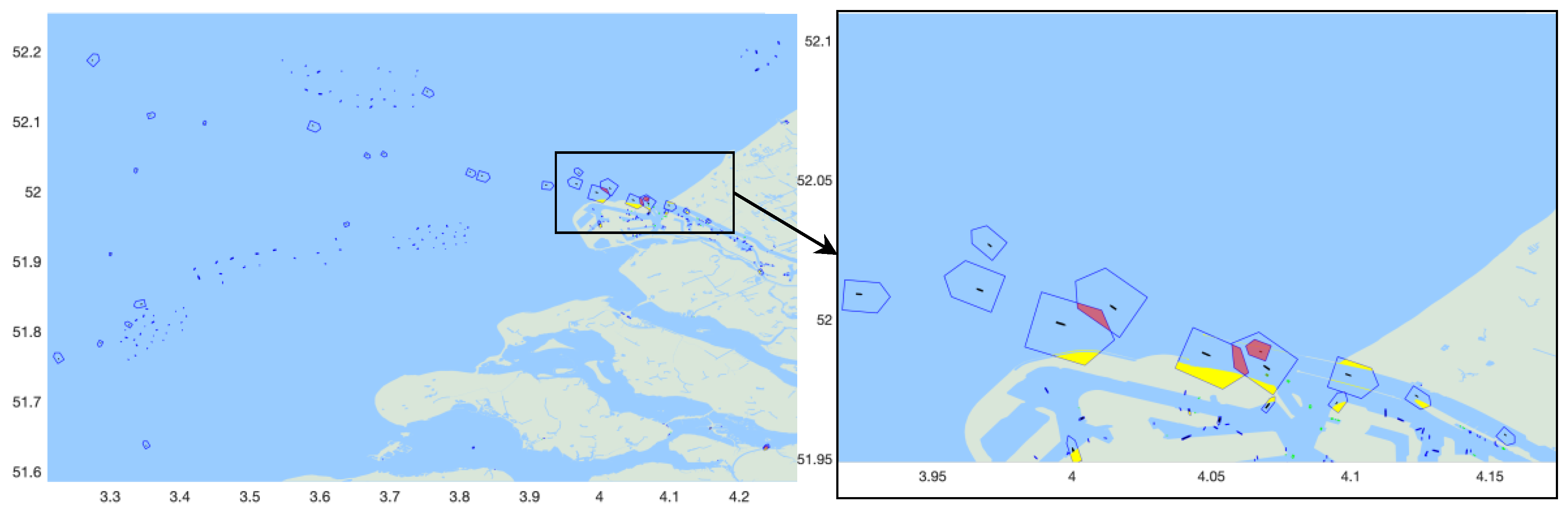
A navigation risk example is demonstrated in
Figure 8 in which all vessels are indicated in black surface, their safety domains in blue lines, collision regions in red and grounding regions in yellow. The vessel domain is updated based on the vessel length and maneuverability depending on its speed for which static vessels have a small domain that accounts only for GPS inaccuracy and imprecision, this is a remarkable advantage compared to theoretical fixed L-dependent domains of
Figure 4 which are oversized. Since moored vessels usually transmit inaccurate
records, they are ignored for grounding risk identification without the loss of generality. In this illustration example, vessel 2 encounters four grounding obstacles that need to be avoided
and vessel 3 is navigating under two potential collision candidates
and
Figure 8 reflects some types of position uncertainties which have been introduced in
Section 2.3 as well as unreliable COG for moored vessels and negligible interpolation errors. Indeed, introducing time to
Figure 8 and verifying the situation over a few successive instances reflects many vessels were just about one minute to collision for many times.
In the next timestamp (after one minute), vessels 1 and 2 will be in a close quarter situation of head on collision and both vessels must alter their course to starboard side according to COLREG rule 14 to avoid accident. This cannot be achieved easily since both vessels are in risk of grounding on their starboard side and both vessels must proceed carefully at safe speed to avoid collision or grounding. Vessel 3 on the other hands cannot overtake vessel 2 on the right side due to limited maneuvering area and the danger of grounding for which it must decrease its speed. However, vessel 3 in this case will impede the route of vessel 4, this action is not allowed by COLREG rule 13. Hence, this situation is navigationally complex and associated with considerable navigational risk and can be identified from a large set of AIS data.
Given the one-year AIS data for the two sample areas described in
Table 1, results of all the identified risky situations are demonstrated in
Figure 9,
Figure 10 and
Figure 11.
Figure 9a and
Figure 10a describe the spatial locations of the identified vessel to vessel collision risks for two different areas and their respective risk distributions are demonstrated in
Figure 9b and
Figure 10b. Variations of both collision and grounding risk over the two areas are both shown in
Figure 11 for the year 2018.
Examples of some risky situations are also illustrated in
Figure 12,
Figure 13 and
Figure 14.
Figure 12 represent a collision-risky situation due to a combination of conflicting overtaking and head-on encounter COLREG rules, the largest vessel is involved in three possible collision situations in which the avoidance of head-on collision (alter course to starboard according to rule 14) would result in a collision with the other two vessels for which this vessel must not impede their routes. This situation can be solved if all the vessels keep their track and speed except the vessel moving northward that must take actions alone to avoid collision. These actions highly depend on its maneuverability.
Figure 13 also describes another situation involving a combination of head on, overtaking and grounding where the avoidance of one accident may result in another accident.
A combination of conflicting navigation maneuvers (crossing and overtaking) is demonstrated in
Figure 14 in which one vessel is in immediate danger of collision with a crossing vessel and an overtaking vessel. This vessel must give way to the vessel crossing on its starboard side according to COLREG rule 15, the later vessel has right of way and is in stand-on maneuver but may take action to avoid collision (rule 17). The first vessel must take substantial action (rule 16) and must not pass in from of the crossing vessel, however, this may result in collision with the overtaking vessel (rule 13).
4. Conclusions
A practical method was presented in this article for the automatic identification of maritime navigation risk in realistic and large-scale applications. The proposed solution has paramount advantages in terms of effectiveness and computational efficiency and plays a crucial role as a warning input for smart navigation and decision support tools as well as in remote control and autonomous navigation technologies. Individual grounding and collision risks were evaluated through an accurate adaptive vessel safety domain that considers the actual navigation parameters as well as vessel dimensions and maneuverability. This approach is based on a correction of blocking area radii in which close quarter situations are addressed through a five-vertices polygonal safety domain. Depending on the type of encounter and danger of collision and/or grounding situations, individual risk was evaluated through a spatial risk function. In this paper, real navigational risk is identified through the combination of multiple candidates of groundings and collisions for a set of interacting vessels over any area and period of time.
The overall method is fast and computation-efficient and exhibits a remarkable possibility to address large-scale navigation monitoring and risk identification. The presented algorithm is supported by a thorough analysis of two large sets of AIS data, each spans one year and covers a large geographical area and are combined with vessel registry and high-resolution digital maps. In addition to high efficiency, the obtained results demonstrate potential applications and illustrate the reliability of the developed methods to identify accurately various aspects of navigation risk. The presented procedure also supports significant future extensions to non-immediate navigation risk identification and prediction to determine safe situations that my cause navigation risk in a while. Another important feature that may be investigated in the future is a deeper analysis of complexity in navigation scenarios regarding COLREGs and special rules while considering weather conditions, visibility, wind, sea state, water depth and tides.
The main limitation of the presented work is in fact a data limitation with the utilization of AIS data only, which limits the applications to decision support rather than the basic tool for collision avoidance. However, the main advantages of the algorithm are its effectiveness and computation-efficiency to analyze big amounts of data for anti-collision support over a large area in a finite time and resources. The algorithm can easily integrate with other navigational systems and access data from more sources for enhanced performance.


