Abstract
The Han Dynasty Ruins in Chengcun Village of Wuyishan City, also known as the Ruins of the Imperial City of the Minyue Kingdom, are located on the hilly slope southwest of Chengcun Village, Xingtian Town, Wuyishan City, Fujian Province, China. These are ruins of a Han Dynasty city. Wuyi Mountain’s World Cultural and Natural Heritage Committee declared it a World Heritage Site in 1999. It is also the only imperial city site from the Han Dynasty that has been declared a World Heritage Site in China, and it is the most well-preserved large-scale imperial city site from the Middle Ages on the Pacific Rim. This study used comprehensive archaeological techniques, including archaeological excavation work, site information recording, erosion situation analysis, and geological surveys, to design and implement protective engineering projects in response to existing problems. In this study, the researchers conducted a geological survey of the study area to analyze the topography, rock and soil distribution characteristics, groundwater storage conditions, and geotechnical engineering conditions. At the same time, they explored the preservation status of the site, including the preservation status of the East Gate and the East City Wall, and they analyzed the causes of damage. Finally, the investigation and analysis results guided the design of a site display project, which included safeguarding against collapse and erosion, treating trees and shrubs, and designing the exhibition project for the East Gate. This study provides some practical reference for the excavation and archaeological work of the royal city in the surrounding areas. At the same time, in terms of the technical process of the project, it is also hoped to provide ideas for international ancient city excavation, display, and protection projects.
1. Introduction
Wuyi Mountain is located in Wuyishan City, Fujian Province, China. The UNESCO World Heritage Committee listed it on the “World Natural and Cultural Heritage List” on 1 December 1999. The UNESCO World Heritage Committee listed it as the fourth unit in China and among the 35 global dual-heritage sites [1]. The rulers of the Han Dynasty (B.C. 206–A.D.23) built a large administrative capital near Chengcun Village in the 1st century BCE. Its massive walls enclose an archaeological site of immense significance [2].
In recent years, more and more studies have adopted a multidisciplinary approach, integrating knowledge from multiple disciplines, such as archaeology, history, geology, and architecture, to conduct a comprehensive analysis of the geological environment and cultural connotations of the site and protective strategies for it [3,4]. Studying the site’s architectural style and urban planning can help historians understand its construction concept and functional layout [5]. Through the analysis of the site’s architectural remains, we can further explore the architectural technology and construction characteristics [6,7]. This kind of urban planning, combined with archaeological research, is of immense value for understanding the development models of ancient cities. Simultaneously, scholars have analyzed the city’s position in the history of urban development by comparing its planning characteristics with those of other cities from that period [8,9]. Therefore, archaeological excavation work is of enormous significance in revealing the layout, structure, and historical changes of the site [10,11,12]. These studies cover the site’s archaeological excavation process, including the discovery and study of relics such as city walls [13,14], palaces [15,16], and tombs [17,18]. On the other hand, site protection is critical for ensuring the site’s sustainable development [19]. Scholars have explored various protection measures and techniques, such as site reinforcement [20], erosion prevention and control [21], and environmental monitoring [22], and they have proposed protection strategies for the site, emphasizing the importance of comprehensive protection. Furthermore, data recording and digital imaging of site space are important research areas in terms of protection and display [23,24,25,26]. Scholars believe that active and passive sensors, data collection methods, implementation algorithms, and computing systems are constantly updating the technology for the 3D digitization of tangible heritage. These developments enable greater automation and higher processing speeds for digitized heritage assets, as well as greater accuracy and precision. For large-scale applications, such as investigations of ancient remains, heritage objects, or architectural details, scanning and image-based modeling methods dominate because of reduced costs and processing times, fast acquisition speeds, and repeatable workflows. These important technologies can also provide similar empirical support for site excavation and exploration in different regions.
As an important historical and cultural site in China, the Ruins of the Imperial City of the Minyue Kingdom have attracted the attention of many scholars in recent years. Scholars have deeply explored the historical evolution, political system, social structure, and cultural exchanges of the Minyue Kingdom with surrounding areas through the analysis of historical documents and archaeological discoveries [27,28,29,30]. For instance, the study of pertinent historical materials elucidated the political status and cultural influence of the Minyue Kingdom during the Han Dynasty. Other scholars have studied the cultural relics unearthed from the site, which helped to reveal the unique characteristics and development context of the Minyue culture. They have conducted a detailed analysis of the pottery, bronze, and other cultural relics unearthed from the site, providing an important basis for understanding the craftsmanship and esthetic concepts of the Minyue culture. However, these studies still focus on one aspect of the site and lack a comprehensive research perspective—in particular, the comprehensive analysis of archaeological excavation, spatial information recording, and site display plans. Therefore, this study attempts to conduct a more comprehensive study and analysis of the Ruins of the Imperial City of the Minyue Kingdom from the perspective of archaeological excavation, protection, and display engineering design practice.
2. Study Area and Methods
2.1. Study Area
The Ruins of the Imperial City of the Minyue Kingdom (also known as the Han Dynasty Ruins in Chengcun Village of Wuyishan City), the “Best-Preserved Imperial City of the Western Han Dynasty (B.C. 206–A.D.23) in the Pacific Rim Countries,” have a history spanning 2200 years [2]. Reports state that the first survey of national cultural relics discovered the ruins in 1958, and Fujian Province and the country listed them as key cultural relics for protection in 1961 and 1996, respectively. In 1999, Wuyishan City’s application for dual world cultural and natural heritage included the ruins in the World Heritage List (Figure 1), selecting them as the overall protection project for large ruins from the Eleventh Five-Year Plan to the Fourteenth Five-Year Plan. In 2013, it became a project unit of the National Archaeological Site Park. It is the only large-scale ancient city site in Fujian Province surrounded by city walls, and it is known as the “Pompeii of the East”. The Ruins of the Imperial City of the Minyue Kingdom, situated south of the Yangtze River in China, are a relatively well-preserved ancient city site from the Han Dynasty. The ruins are unique in terms of site selection, architectural techniques, and style. They are a representative and model of the capitals of local vassal states in the country at that time and embody the civilization of the ancient Minyue Kingdom, which has disappeared.
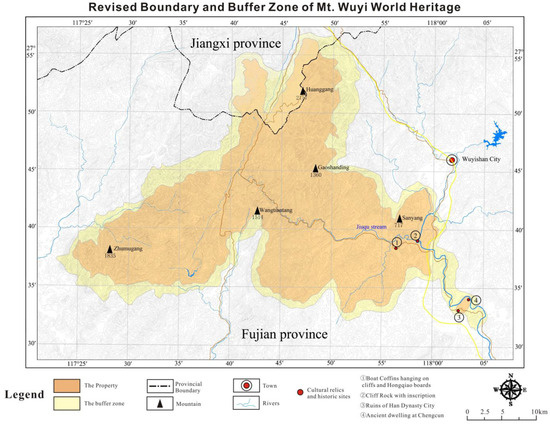
Figure 1.
Map of Mount Wuyi with minor boundary modifications inscribed (image source: UNESCO World Heritage Center, https://whc.unesco.org/en/list/911/maps/, (accessed on 15 August 2024).
Wuzhu (无诸), the King of Minyue (闽越王), constructed the imperial city in 202 BC after receiving the title from Emperor Gaozu of Han, Liu Bang (刘邦), during the early Western Han Dynasty. An inner city and an outer perimeter divide the city, with suburbs covering an area of 14.6 km2 and the imperial city itself occupying an area of 480,000 km2. Built on a rolling hilly area, the imperial city of Minyue features a rammed earth wall spanning over 2,000 m, whose outline is vaguely discernible. On the city wall, there are towers and beacon towers with a rigorous layout and style similar to that of the Qin capital and the Han Palace. The two city gates are located in the southern part of the city site, and there is a straight road connecting the east and west. Researchers have discovered four large-scale building complexes, five iron smelting workshop sites, drainage systems, ancient roads, and other sites within the city. The central building area of the imperial city is known as Gaohuping. The large palace building sites include the main hall, side rooms, courtyards, patios, drainage ditches, etc., which are well preserved. Since the site’s trial excavation in 1958, researchers have unearthed tens of thousands of cultural relics from the Han Dynasty, each of which holds significant value. Many of them are among the best of similar cultural relics in the country, such as the largest patterned hollow brick in the country, the longest iron spearhead in the country, the earliest shaped pottery sewer pipe in the country, and the luxurious bath in the palace. Museums near the site exhibit some of these cultural relics, which represent the pinnacle of Chinese civilization at that time (Figure 2).
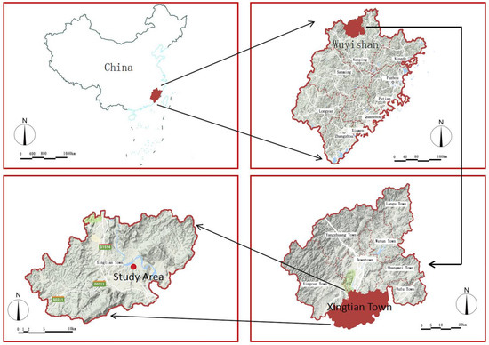
Figure 2.
Location analysis (image source: drawn by the author).
2.2. Research Methods and Process
The Ruins of the Imperial City of the Minyue Kingdom are an important cultural site in southeastern China. The decision-making process for the measures for their archaeological excavation and protection is a multi-stage, interdisciplinary, and comprehensive process. This process emphasizes comprehensive research and clear goals under the guidance of science and technology to ensure the maximum protection and rational use of the ruins and cultural relics. These experiences are also of immense reference value for archaeological work at similar sites in other regions. This includes the following:
(1) Preliminary research and data collection using historical documents and archaeological data: Before excavation, archaeologists first needed a comprehensive understanding of the site’s historical background, documentary materials, and previous archaeological excavations, including the cultural characteristics, layout, and important discoveries.
(2) Geographic information survey: A geographic information system (GIS) and remote sensing technology were used to obtain an overview of the site, including its topography, soil type, and hydrological conditions, in order to provide a scientific basis for subsequent excavation planning. (a) Topographic and geomorphic analysis: The site’s topography and geomorphology, including mountains, terrain, peaks, low points, and so on, as well as the topographic features inside the site, such as hilly plateaus, river distribution, altitude, slope, and so on, were surveyed. (b) Survey of rock and soil distribution characteristics: Using on-site core drilling, field surveys, and in situ testing, we divided the foundation soil layer and described its color, humidity, state, composition, thickness, bottom elevation, standard penetration test results, and other characteristics. (c) Analysis of groundwater storage conditions: We analyzed the type, storage location, recharge and discharge methods, water-level changes, water content, and permeability of the aquifer based on drilling results. (d) Geotechnical engineering analysis and evaluation: Utilizing the China Earthquake Motion Parameter Zoning Map and pertinent specifications, we analyzed and evaluated the seismic fortification intensity, basic earthquake acceleration value, characteristic period, suitable engineering construction type, fault structure, adverse geological effects, and geological hazards of the site. We also classified and evaluated the engineering performance of the rock and soil layers.
(3) Site survey and preliminary assessment: (a) non-invasive exploration techniques: Ground-penetrating radar (GPR), magnetometers, and resistivity measurements were used to conduct a non-invasive preliminary exploration of the site. This stage was intended to identify potential structures, relics, and remains, as well as to assess the feasibility of excavation. (b) Delineation of key areas: Based on the preliminary survey results, areas that needed to be excavated were identified and delineated to ensure the rational allocation of resources.
(4) Setting excavation goals: (a) clarifying research goals: After determining the excavation area, the team held a meeting to clarify the specific goals of the archaeological excavation, such as revealing the structure of the city wall, the layout of the site, and the discovery of related relics. The site underwent archaeological excavation, which included the excavation of the East Gate and the East City Wall, with the aim of understanding the layout, structure, and preservation status of the site. (b) Setting a time frame and budget: A detailed excavation plan was created based on the goals and staffing, a time frame and budget was established, and the project’s feasibility and effectiveness were ensured.
(5) Selecting the excavation method: (a) A technique was chosen based on the environment and site characteristics. The site conditions, preservation conditions, and research objectives guided the selection of a suitable excavation method. Typically, the following factors inform such decisions: manual excavation and mechanical excavation. We chose manual excavation in more sensitive or well-preserved areas to minimize site damage. Mechanical equipment may be required when stripping soil over large areas. (b) Layering and gridding: We typically used layered excavation and gridding to ensure accurate recording and analysis of the relics, thereby facilitating later analysis and display.
(6) The sixth step involved investigating the site’s preservation status. (a) East Gate site exploration: A detailed investigation of the tower, doorway, guard room, and other parts of the East Gate site, including the building structure, size, preservation status, column holes, and foundation stone distribution, was conducted. (b) Exploration of the East City Wall site: An investigation of the height, topography, stratigraphic structure, wall composition, rammed earth layers, ramming methods, wall foundation, wall dimensions, and preservation status of the inner and outer wall skins of the East City Wall was conducted. (c) Since the Ruins of the Imperial City of the Minyue Kingdom are earthen sites left in the open air, the surface is mostly covered with wild vegetation. These wild vegetations are the primary cause of biological erosion on the site. Researchers used the sampling strip method and the treading method in the field survey to conduct an overall survey of the plants in the site area, taking into account the environment and vegetation distribution. We set up a sampling strip with a bandwidth of 5 m around the edge of the platform in the open-air earthen site. In this sampling strip, five groups of sample plots were set up, each containing three tree sample plots (30 m × 5 m), and their locations were set on the south, north, and west sides of the platform where natural vegetation had grown. In each tree sample plot, a shrub sample plot (3 m × 3 m) was set up, and in each shrub sample plot, a grass sample plot (1 m × 1 m) was set up. We investigated the plants inside the large area of the platform base using the treading method.
(7) Real-time monitoring and adjustment: (a) on-site supervision and quality control: We conducted real-time monitoring during the excavation process, taking detailed records and photographs of each layer of soil and the relics found to ensure the integrity of the information (Figure 3 and Figure 4). The on-site findings were used to flexibly adjust the excavation methods and procedures. (b) Teamwork and senior consultants: We closely cooperated with experts in other disciplines, such as cultural relic protection experts and soil scientists, during the excavation process to ensure the scientific execution of the excavation work.
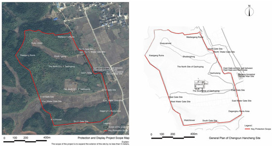
Figure 3.
General plan of the Ruins of the Imperial City of the Minyue Kingdom (image source: drawn by the author).
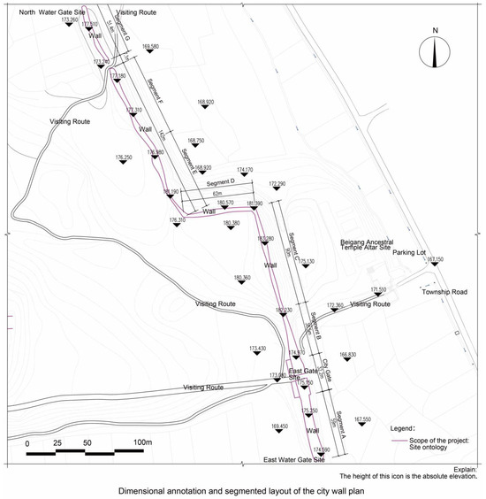
Figure 4.
A plan involving the dimensioning and segmentation of the layout of the city wall (image source: drawn by the author).
(8) Data collection and analysis: (a) collation of artifacts and records: After the excavation, the artifacts were carefully collected, classified, labeled, and merged with previous records. Preliminary analysis was conducted, and data were collected for subsequent research as soon as possible. (b) Erosion situation analysis: We conducted an analysis of the surface damage, such as erosion, collapse, and tree and shrub growth, present at the site. This analysis included an examination of the causes of these surface damage, their manifestations, their distribution locations, and their impacts on the site. (c) Project quantity statistics: We conducted a preliminary statistical analysis to determine the number of projects necessary for the site’s restoration. These projects included the treatment of trees and shrubs, the planting of vegetation, the protection against erosion and collapse of each city wall section, crack-bonding treatment, and the repair of the brick wall at the East Gate site. (d) Simultaneously, the research team analyzed and recorded the damage information of the plants on the site’s surface, specifically focusing on the condition of the plants experiencing root splitting collapse. We chose our survey time in February, when the vegetation had not yet sprouted new leaves, to clearly observe the crack information and conduct the measurement work. Next, the research team utilized the image analysis method from the soil collapse study to gather fundamental data on the platform edge collapse. The team measured and recorded the specific length of the crack with a steel ruler while taking pictures with a camera, and then processed the photos with a resolution of 600 dpi using PS software (2021 version). We measured the length and diameter of the roots in the gap, as well as the specific length and width of the crack, using a steel ruler and a vernier caliper to determine the maximum and minimum values. We then calculated the crack area through image analysis. The multiple indicators of the aboveground part corresponding to the crack (such as tree height, breast diameter, base diameter, etc.) were measured in detail, and the plant species were recorded. (e) Report writing and publication of results: A detailed archaeological report summarizing the excavation experience, results, and protection suggestions was compiled and published on an appropriate platform to promote academic exchanges.
(9) Long-term protection and maintenance: (a) formulation of protection measures: Based on the excavation results, a long-term protection strategy was formulated, and it included monitoring the site’s current status, implementing environmental protection measures, and protecting the discovered cultural relics. (b) Public participation and publicity: Through education and publicity activities, public awareness of site protection was raised, social participation was encouraged, and a joint force for protection was formed.
3. Results
3.1. Geological Survey
3.1.1. Analysis of Topography and Geomorphology
Mountains surround Wuyishan City to the east, west, and north. The main ridge of the Wuyi Mountain Range stretches across the northwestern border. The terrain is generally high in the northwest and low in the south. The highest peak in the area, Huanggang Mountain, is 2158 m above sea level, making it the highest peak in Fujian Province. The lowest point is Xingtian Town, 160 m above sea level, and the difference between the highest and lowest points is 1998 m. The central part is the Wuyishan Scenic Area. The unique monocline rock layer (dipping to the northwest with an inclination of 15–30°) constitutes the typical Danxia landform of Wuyi Mountain. The scenic area is full of gullies; the natural slope of the mountain is 30–50°, and some of these gullies form vertical cliffs. The main landform types include tectonic erosion, denudation landforms, and accumulation landforms.
The interior of the Minyue Kingdom’s Imperial City is a gentle, hilly plateau. The east side is close to Chongyang Creek (500 m away), and the north side is 300 m away from Chong Creek. Two inner-city rivers divide the city into three parts: Dagangtou in the south, Madaogang and Sangang in the north, and Gaohuping, Xiasigang, and Xiasiping in the middle. Dagangtou and the Wuyi Mountain ruins in the city are the absolute highest, with an altitude of 230 m. Gaohuping and Xiasiping, located in the city, exhibit a relatively flat altitude of 180 to 195 m, while Wangdianlong and Shuitonglong, situated in the city’s low-lying areas, serve as inner rivers, boasting an average altitude of less than 170 m and a relative height of 55 m. The terrain slopes in the northwest and southeast corners of the city are relatively steep, with a maximum slope of 31 degrees; the slopes on the north and southwest sides of the northern water barrel ridge are 10–20 degrees, accounting for 50% of the royal city’s land; the slopes on both sides of the southern Wangdian ridge and the east side of the northern water barrel ridge are relatively gentle, less than 10 degrees, occupying 45% of the land. This area is suitable for arranging large palace buildings. According to the 1/500,000 geological map of Fujian Province, there are no large fault structures passing through the site, and there are no adverse geological phenomena that affect its stability.
3.1.2. Rock and Soil Distribution Characteristics
By looking at the field core drilling images, the site survey information, and all of the in situ test results, we were able to divide the foundation soil layer into six layers: miscellaneous fill, cultivated soil, clay, silty clay, pebbles, and strongly weathered granite. These layers were all within the control depth range of the drilling hole. The specific description of each rock and soil layer is as follows:
(1) Miscellaneous fill (Q4 ml): Grayish yellow, black, slightly wet to wet, loose to somewhat dense, poor uniformity; the filling time is about 10 years; mainly soft plastic to plastic clay; containing pebbles, gravel, strongly weathered rock blocks, and other hard materials; hard materials account for about 35%; this layer is evenly distributed in most sites; the exposed thickness is 1.6–0.4 m; the layer’s bottom elevation is 173.87–171.34 m.
(2) Cultivated soil (Q4 pd): Gray to gray-black, soft and plastic, mainly clay soil, rich in plant roots in the upper part. This layer is distributed in most sites, and it has an exposed thickness of 0.6 to 0.5 m and a bottom elevation of 173.93 to 171.14 m.
(3) Clay (Q4 al+pl): Light yellow, slightly wet to wet, plastic, primarily alluvial in origin, no shaking reaction, somewhat smooth cross-section, medium dry strength, and toughness. The site exposes this layer, which ranges in thickness from 4.6 to 1.6 m and has a bottom elevation of 171.93 to 168.74 m. The standard penetration test produced an actual number of 8 to 11 hits, while the rod length correction produced 8.0 to 10.7 hits compared with the standard value of 9.5.
(4) Silty clay (Q4 al+pl): Light yellow, slightly wet to wet, plastic, mainly of alluvial and diluvial origin, no shaking reaction, somewhat smooth cross-section, medium dry strength and toughness. This layer is exposed in most sites; it ranges in thickness from 3.9 to 1.8 m and has a bottom elevation of 169.73 to 165.74 m. The actual number of blows in the standard penetration test was 9 to 13; the number of blows after correction with the rod length was 8.5 to 12.0, and the standard value was 10.4 blows.
(5) Pebbles (Q4 al+pl): Grayish white to grayish yellow, formed by river alluvial deposits, very wet to saturated, slightly dense to medium dense, particle size of 20–60 mm, content of 50–55%, some slightly larger particle sizes, pebble composition of mainly granite and hard rock, skeletal particles are slightly weathered, pebble particles are mainly sub-circular, roundness is good, relatively hard, mainly filled with medium-coarse sand, chaotic arrangement, poor sorting, poor cementation, general grading. This layer is distributed throughout the entire area; the exposed thickness is 6.6–2.1 m, the layer’s bottom elevation is 165.73–161.92 m, and the re-probe measured 6–17 hits; after rod length correction, there were 5.29–14.76 hits, and the standard value was 9.4 hits.
(6) Strongly weathered granite (r53): Its color ranges from brownish yellow to grayish white, with a small amount of grayish green. Its structure is fragmented, with the main mineral components being feldspar, quartz, and mica. It has strong weathering and developed cracks. The upper part of the core is in the form of loose and fragmented blocks, with a fragment content of 30–40%, while the lower part is in the form of short columns. The original rock structure is clear, and it is a relatively hard rock; the rock mass is in the form of a fragmented structure, which is fairly broken; the basic quality grade of the rock mass is Grade IV. This layer is thicker on the east side of the site, with an exposed thickness of 6.2–3.4 m. The actual number of blows in the standard penetration test was 52–62, the number of blows after correction with the rod length was 42.1–49.6, and the standard value was 45.4.
3.1.3. Groundwater Storage Conditions
According to the drilling, the groundwater on the site is mainly porous groundwater stored in the pebble layer; miscellaneous fill soil, cultivated soil, clay, and silty clay are weakly permeable soil layers, while the pebble layer is a highly permeable soil layer. Strongly weathered muddy siltstone can be regarded as a relatively impermeable layer. The groundwater level is 8.7 to 2.1 m below the ground, with an elevation of 165.50 to 169.23 m. The initial level of water is basically the same as the stable level. The aquifer is weak in water richness but strong in permeability. Atmospheric precipitation and lateral recharge from adjacent aquifers primarily recharge groundwater, while underground runoff and ground evaporation primarily discharge it. The groundwater levels change by about 0.5 to 1.5 m depending on the season.
3.1.4. Geotechnical Engineering Analysis and Evaluation
According to the China Earthquake Motion Parameter Zoning Map, the proposed site is located in an area with a seismic fortification intensity of less than VI. The basic earthquake acceleration design value is less than 0.05 g, and the characteristic period of the seismic response spectrum is 0.35 s. The Code for the Seismic Design of Buildings (GB50011-2010) identifies the site as a general area suitable for engineering construction, disregarding the impact of sand liquefaction and soft soil subsidence on the proposed buildings. According to the investigation, there are no large fault structure zones passing through the site, and there are no adverse geological effects and geological disasters such as debris flows, landslides, and karst caves in the site and nearby areas. The research team found no air-raid shelters, boulders, or other buried objects within the site that were unfavorable to the project. We found no caves, free surfaces, or broken rock bodies in the bedrock of the site. The site’s current status is generally stable.
We can divide the evaluation of the geotechnical layer into two categories: (1) Miscellaneous fill, which is loose, poorly uniform, and lacks engineering performance, making it unsuitable for the shallow foundation-bearing layer of the proposed building. (2) Cultivated soil, which is soft and plastic, has poor engineering performance, and is not suitable for the proposed building’s shallow foundation-bearing layer. (3) Clay is a plastic material with a moderate top plate burial depth, no weak underlying layer, good engineering performance, and a characteristic bearing capacity value of fak = 180 kpa, making it an ideal shallow foundation-bearing layer for the proposed building. (4) Silty clay can be selected for the proposed building as its foundation-bearing layer due to its plastic nature, good engineering performance, and high bearing capacity. (5) Pebbles can be selected as the foundation-bearing layer for the proposed building due to their high strength, good engineering performance, and large thickness. (6) Strongly weathered granite, which is evenly distributed throughout the site and has a high strength, good engineering performance, and large thickness, can be used as a pile foundation-bearing layer of the proposed building. In summary, the site’s foundation soil is stable and has excellent uniformity, small layer fluctuations, and strong regularity. The choice of a good foundation form and bearing layer is appropriate for the project’s construction and implementation.
3.2. Archaeological Findings
After the archaeological excavation, the East Gate was backfilled for protection, and a boundary display with simple outlines was made, with glass windows in some parts. It was urgent to carry out the protection of the main building of the ruins and upgrade the display facilities of the East Gate based on a thorough study of the archaeological excavation results and the main building survey and analysis. The majority of the city wall, from the East Gate to the North Gate, was covered by vegetation, leaving only the outline visible, and some parts had seriously collapsed and eroded. Therefore, it was crucial to take the necessary measures for the protection and display of the body of a building. The survey of the East Gate and the city wall between the East Gate and the North Gate, along with the results of the archaeological excavation, indicated that the primary problems affecting the protected objects were erosion, collapse, and the growth of trees and shrubs. Specifically, (1) Erosion is caused by continuous erosion and concavity under the action of wind, rain, water, etc., either alone or in combination. Erosion mainly occurred in the area near the bottom of the city wall (Figure 5). (2) Collapse: Due to the influence of natural factors, the soil exhibited numerous unloading and shrinkage cracks. Rainwater erosion caused the cracks to cut into the façade of the remains, thereby reducing their foundation strength. This, in turn, can lead to local large-scale collapse, posing a significant threat to the safety of the remains (Figure 6). (3) Growth of trees and shrubs: The relatively humid climatic conditions in the Ruins of the Imperial City of the Minyue Kingdom’s vicinity foster the growth of vegetation (Figure 7). Vegetation has a protective effect on the city wall to a certain extent. However, the growth of trees and shrubs on the city wall will cause the soil of the ruins to become loose, resulting in local collapse, which has caused a certain degree of damage to the cultural relics themselves.
Figure 5.
Typical erosion of the soil remains (image source: provided by the excavation team for the Ruins of the Imperial City of the Minyue Kingdom).
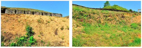
Figure 6.
Typical collapse of soil remains (image source: provided by the excavation team for the Ruins of the Imperial City of the Minyue Kingdom).
Figure 7.
Typical growth of trees and shrubs in the soil remains (image source: provided by the excavation team for the Ruins of the Imperial City of the Minyue Kingdom).
In addition, only the building foundation remained at the East Gate; it was backfilled for protection after the archaeological excavation, and a simple-outline boundary display was made, with glass windows in some parts. The display work of the East Gate and the wall from the East Gate to the North Gate has been lagging for a long time; the East Gate and the wall from the East Gate to the North Gate are in a natural open-air state, without signboards and a lack of systematic display facilities. The bricks and stones used for the display are severely damaged and missing (Figure 8).
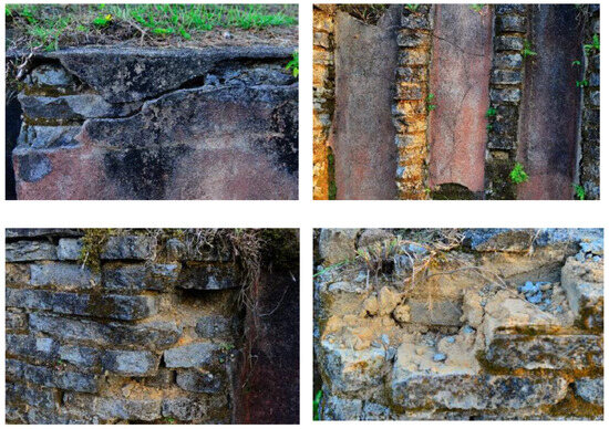
Figure 8.
The displayed bricks and stones are partially cracked or missing (image source: provided by the excavation team for the Ruins of the Imperial City of the Minyue Kingdom).
3.2.1. Preservation Status of the East City Gate Ruins
(1) Construction of the towers is underway on both sides of the East City Gate. Excavations have revealed that on both sides of the gate, only the towers (rammed earth platforms) remain on the ground, with a height of about 1.8 to 2 m on the north side and about 2.8 to 4 m on the south side, as well as a slightly semicircular cross-section. The city wall, measuring 7.6 m wide, connects the southern and northern ends. From east to west, the tower measures 9.4 m wide, with the southern tower measuring 13.5 m long and the northern tower measuring 14.3 m long (Figure 9). The eastern and western walls are in excellent condition, having been fired to form a sintered surface with a thickness of approximately 5 cm. Most of the outer side (east side) has fallen off, while the inner side (west side) is well preserved, with a remaining height of about 150 cm. Only the gate’s pillar holes and foundation stone survived the severe collapse of the platforms on both sides of the walls. We cleared only the wall surface, leaving the foundation of the Que (tower) intact, to preserve its remains. The research team found no traces of splints or sticks on the cleared part. The base was rammed layer by layer of red soil, 10 to 15 cm thick, with a round-bottom rammed hole that was 5 cm in diameter and 3 to 4 cm deep. Whether they dug the foundation into a groove remains unclear. On the wall of the Que foundation, the remains of the column wall grooves were cleared; the inner wall of the grooves was all burned into baked red soil, and some column grooves still had burnt charcoal columns. According to the above signs, the original columns were all clamped to the wall, with one side exposed and parallel to the wall surface. The outer walls (eastern walls) of the southern and northern Que each have seven columns with symmetrical distances, and there are 14 existing column grooves (numbered Z1 to Z14), all of which are deeply buried column hole structures. The inner wall (western wall) is the junction of the Que platform and the guardhouse foundation. There are 16 existing column grooves. Some are single, and some have two or three column positions side by side. We distributed the column holes and foundation stones cleared from the foundation into 23 column positions (numbered Z15 to Z37).
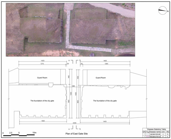
Figure 9.
Plan of the East Gate site, a and b in the figure represent the positions of the sections. (image source: drawn by the author).
(2) Doorway: There is only one doorway in the East City Gate, between the south and north gates, facing east and west (Figure 10, Figure 11 and Figure 12). The gate is 4.5 m wide and 9.2 m long (i.e., the thickness of the Que). Rainwater later washed the gate, situated in a low-lying area, into a large ditch, leaving only the northwest triangular ground untouched. After tamping, the ground became a purple–red concrete surface due to the collapse and burning of the building, with a thickness of 5 to 15 cm. On both sides, the gate is basically perpendicular to the Que, and the wall surface has fallen off. On both sides of the gate, there are nine column remains on the foundation of the Que—five on the north side and four on the south side, with one missing on the east side. These columns are arranged symmetrically from east to west. There are three on the northwest side, and one on the south side is a double column with a column hole and a foundation stone standing side by side. The others only have column holes and were numbered Z40 to Z48.
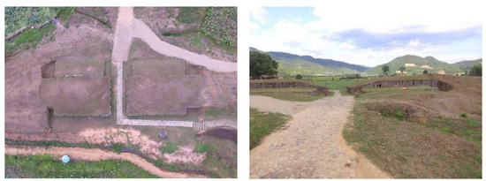
Figure 10.
The photographs show the plan of the East City Gate ruins and the doorway, taken from west to east (image source: provided by the excavation team for the Ruins of the Imperial City of the Minyue Kingdom).
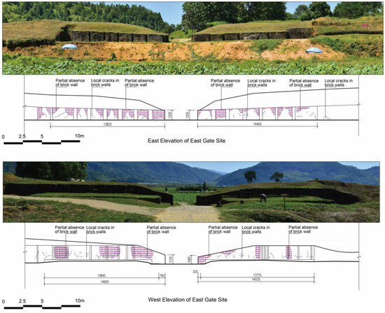
Figure 11.
East and west elevations of the East Gate site (image source: drawn by the author).
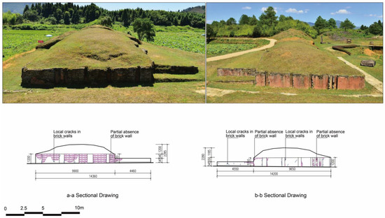
Figure 12.
Sectional drawing (please refer to Figure 9 for the details of cuts a-a and b-b) (image source: drawn by the author).
(3) Guardhouse: The north and south guardhouses are located on the south and north sides of the inner side (west side) of the East Gate, in close proximity to the Que. The ground beneath the foundation was rammed, hard, and had a purple–red hue. The collapse of the building caused the fire to scorch the ground, transforming it into a solid, red-colored earth surface. The south guardhouse has a rectangular base that is 12.3 m long from north to south and 4.8 m wide from east to west, and it lies 1.25 m above the ground of the gate. There are three steps connecting the base’s north edge to the gate. The first step is 30 cm high and 125 cm wide; the second step is 40 cm high and 35 cm wide; the third step is 20 cm high with respect to the base surface. There is severe damage on the northwest side of the base. The west edge’s base has four north–south column holes. The south edge of the base is well preserved, with two east–west column grooves. About 60 cm away from the west wall of the Que, there is a wall relic parallel to the Que wall that is 900 cm long, 10–20 cm high, relatively flat, and pink. Four pillar holes, which are aligned with the Z54 pillar’s east–west position and arranged symmetrically with the pillar holes along the platform, are present in the wall. In the north gate guard room, the platform is rectangular, 12.5 m long from north to south, 4.8 m wide from east to west, and 1.35 m higher than the ground of the doorway. Trenching damaged the west edge of the platform, leaving only two pillar holes (numbered Z59 and Z60) at the bottom of the trench. The south edge of the platform is well preserved and connected to the doorway by three steps; the first step is 35 cm high and 110 cm wide. We found a pillar hole with the number Z61 at the west end of this step, 4 m from the southwest corner of the Que. The second step is 50 cm high and 30 cm wide. This step is located on the west end, 430 cm from the Que platform wall. A column hole numbered Z62 was found. Trenching damaged it, leaving only the bottom of the column hole intact. On the platform surface, the third step is 20 cm high. The north and south guardhouses have rectangular planes, and the platform surface is about 1.3 m higher than the gate’s road surface. There are three steps leading to the guardhouse from the gate. The platform’s living surface should be reached by a wooden ladder from the first step’s width to the second. The distribution of the above-mentioned column hole remains, the red burnt-earth ground, a large number of collapsed tiles from the Han Dynasty, and the accumulation of burned charcoal marks should be the remains of the auxiliary buildings in the city gate tower. We found carbonized bamboo weaving remains on the ground of the north gate guardhouse, likely resulting from the collapse of the woven bamboo canopy within the house. We found bundles of arrows on the west side of the north gate guardhouse’s platform.
3.2.2. Preservation Status of the East City Wall
According to the East City Wall’s partial excavation results (Table 1 and Figure 13), the terrain on the west side of the remaining wall is relatively flat, with a remaining height of 3.9 m; the slope on the east side is relatively large, and the wall is 6.3 m high. In terms of overall terrain, the ground inside the city wall is 2.4 m higher than the ground outside the city wall. At the same time, the strata of the exploration trench of the east city wall are relatively simple, mainly the remains of the city wall. From the remains and structure of the east city wall, only the main wall is seen, and no inner and outer protective walls are seen. It is 5.5 to 6 m wide and 4.5 m high. Rammed red soil forms its composition. There are 47 layers of rammed earth. Each layer has a hard upper part and a loose lower part. Only a 5–6 cm thick rammed layer exists, and the entire layer exhibits intense ramming. Each layer contains dense rammed holes that overlap, indicating the use of the ramming method. The rammed holes are round, with diameters of 3 cm and 6 cm. The depth of the rammed holes is generally 1 to 2 cm, and some are 5 cm deep. The research team dug the wall foundation (1st to 14th layers) in the raw soil. The top of the foundation trench is larger than the bottom, with a width of 7.6 m and a bottom of 7.3 m. Due to the height difference between the inside and outside, the inner wall foundation is 1.5 m deep and has 14 rammed layers; the outer wall foundation is 0.4 m deep and has three rammed layers. The rammed earth is pure red soil, with a small amount of green soil in it. The bottom two layers are the hardest. The wall is 2.2 m high from the inside (15th to 47th layers) and 2.6 m high from the outside (4th to 47th layers); the upper width is 5.5 m, and the lower width is 6 m. The intersection of the lowest layer of the wall and the foundation widens the inner side by 0.3 m and the outer side by 0.5 m. Reddish brown soil and a large number of small river pebbles frame the upper part of the city wall (47th to 33rd layers). In the top rammed layer, there is a fracture. The rammed earth in the middle (32nd to 28th layers) contains scattered river pebbles and quartz sand, while the rammed earth in the lower part (27th to 15th layers) contains pure red soil. Inside and outside the city wall, most wall skins have fallen off. The upper half of the inner wall skin has collapsed, and the wall surface, which is 1.3 m high, has been retained in the lower half after the skin has fallen off. Near the wall base, there is a preserved layer of roasted wall surface, measuring 2.5 mm in thickness. The upper half of the city wall’s outer wall skin has also fallen off, and the lower half is well preserved. The falling surface is 2.3 m high. The red roasted-earth wall skin has completely fallen off, and a large amount of red roasted-earth and charcoal accumulation remains on the ground on the inner tile side of the city wall. Someone may have rammed plywood into the city wall. No traces of plywood remain, as the inner and outer walls have collapsed. The research team found no traces of sticks between the rammed layers.
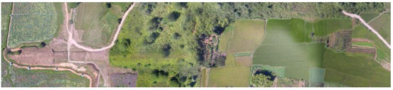
Figure 13.
Aerial photo of the remains of the East City Wall (image source: provided by the excavation team for the Ruins of the Imperial City of the Minyue Kingdom).

Table 1.
Preservation status of the East City Wall.
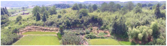
Figure 23.
Section D of the East City Wall (image source: provided by the excavation team for the Ruins of the Imperial City of the Minyue Kingdom).
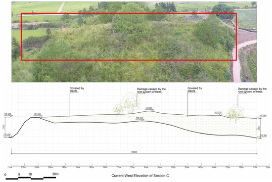
Figure 22.
West facade of Section C of the East City Wall, the red outline indicates the main area (image source: drawn by the author).
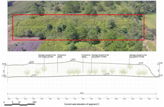
Figure 21.
East facade of Section C of the East City Wall, the red outline indicates the main area (image source: drawn by the author).
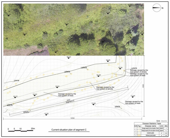
Figure 20.
Surveying and mapping status of Section C of the East Gate site (image source: drawn by the author).
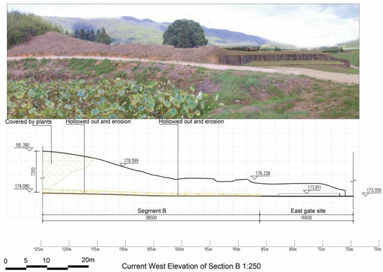
Figure 19.
West facade of Section B of the East City Wall (image source: drawn by the author).
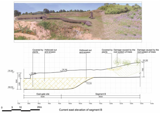
Figure 18.
East facade of Section B of the East City Wall (image source: drawn by the author).
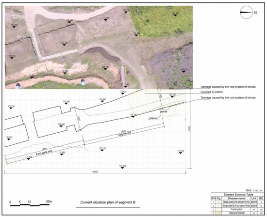
Figure 17.
Surveying and mapping status of Section B of the East Gate site (image source: drawn by the author).
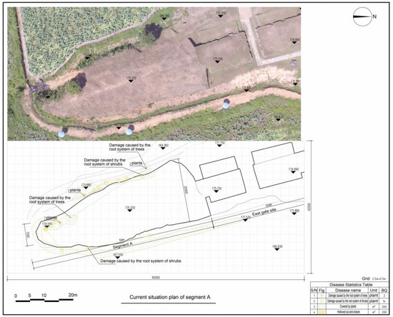
Figure 16.
Surveying and mapping status of Section A of the East Gate site (image source: drawn by the author).
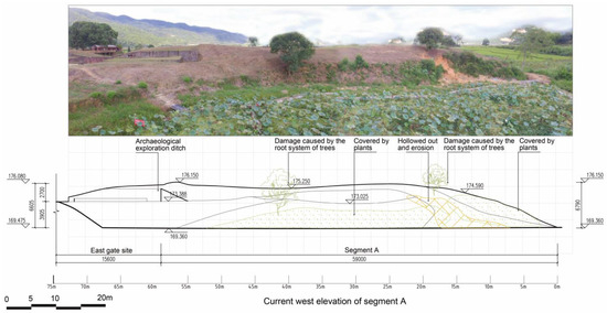
Figure 15.
Western facade of Section A of the East City Wall (image source: drawn by the author).
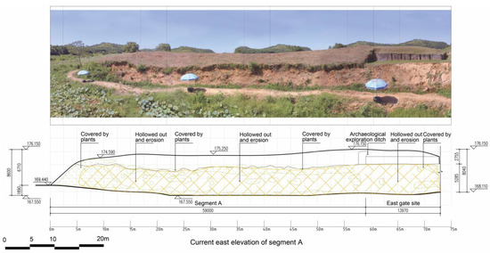
Figure 14.
Eastern facade of Section A of the East City Wall (image source: drawn by the author).
Table 1.
Preservation status of the East City Wall.
| Wall Segmentation | Current Situation Description | Surface Damage Statistics |
|---|---|---|
| Section A (Figure 14, Figure 15 and Figure 16) | (1) There are trees and shrubs growing in some parts of the city wall; the entire city wall is covered with vegetation. (2) There is serious erosion on some parts of the facade. | Tree root erosion: 2 trees |
| Shrub root erosion: 14 trees | ||
| Vegetation coverage: 260 m2 | ||
| Erosion: 200 m2 | ||
| Section B (Figure 17, Figure 18 and Figure 19) | (1) There are trees and shrubs growing in some parts of the city wall; the entire city wall is covered with vegetation. (2) There is serious erosion on some parts of the facade. | Tree root erosion: 3 trees |
| Shrub root erosion: 4 trees | ||
| Vegetation coverage: 95 m2 | ||
| Erosion: 113 m2 | ||
| Section C (Figure 20, Figure 21 and Figure 22) | (1) The growth of trees and shrubs in some parts of the city wall. (2) The entire city wall is covered with vegetation. | Tree root erosion: 25 trees |
| Shrub root erosion: 49 trees | ||
| Vegetation coverage: 1136 m2 | ||
| Section D (Figure 23) | (1) There are trees and shrubs growing in some parts of the city wall; the entire city wall is covered with vegetation. (2) There is serious local collapse. | Tree root erosion: 24 trees |
| Shrub root erosion: 62 trees | ||
| Vegetation coverage: 786 m2 | ||
| Collapse: 102 m2 | ||
| Section E | (1) The growth of trees and shrubs in some parts of the city wall. (2) The entire city wall is covered with vegetation. | Tree root erosion: 3 trees |
| Shrub root erosion: 77 trees | ||
| Vegetation coverage: 763 m2 | ||
| Section F | (1) There are trees and shrubs growing in some parts of the city wall; the entire city wall is covered with vegetation. (2) There is serious local collapse. | Tree root erosion: 3 trees |
| Shrub root erosion: 87 trees | ||
| Vegetation coverage: 721 m2 | ||
| Collapse: 35 m2 | ||
| Section G | (1) There are trees and shrubs growing in some parts of the city wall; the entire city wall is covered with vegetation. (2) There is serious local collapse. | Tree root erosion: 56 trees |
| Shrub root erosion: 52 trees | ||
| Vegetation coverage: 589 m2 | ||
| Collapse: 42 m2 |
Source: Provided by the excavation team for the Ruins of the Imperial City of the Minyue Kingdom.
3.3. Damage Cause Analysis and Measures
3.3.1. Damage Cause Analysis
Following the archaeological excavation of the East Gate ruins, the Fujian Imperial City of the Minyue Kingdom Museum arranged temporary backfill protection, created a simple display of the East Gate ruins, and regularly maintained the city wall between the East Gate and the North Gate. These actions played a protective role for both the East Gate and the city wall between the East Gate and the North Gate. The following factors are the primary causes of the current damage to the protected objects.
(1) Impact of water: Rainwater erosion exacerbates soil erosion of the city wall, potentially leading to or exacerbating local collapse or erosion in severe cases. Furthermore, rainwater erosion can easily carry away the soil on the surface of the city wall and continue to erode along it, resulting in a significant loss of cultural deposits and seriously damaging the authenticity and continuity of the site.
(2) Plant damage: Trees and shrubs thrive on the main building of the city wall ruins, causing the soil to become loose and soft, and making it susceptible to collapse and falling off. Under the combined effects of factors such as heavy rain, water melting, and leakage, a local collapse occurred, causing a certain degree of damage to the main building of the cultural relics and seriously affecting the interpretation of the city wall ruins.
(3) The brick and stone base material of the East Gate ruins is partially cracked or missing due to long-term exposure to natural factors such as wind, sun, and alternating dry and wet weather.
(4) Impact of human factors: In later periods, humans opened roads on the city wall, causing damage to the ruins. Drainage issues were not considered when building these roads, resulting in water easily accumulating on the road surface, which was not conducive to the preservation of the city wall.
Table 2 displays the preliminary engineering quantity estimation for the site restoration based on the analysis of the aforementioned issues (Figure 24 and Figure 25). The steps involved in crack-bonding treatment are as follows. (1) Preparing the bonding surface: A brush or similar tool is used to clean the surface of the fractured brick body. If required, a portion of the bonding area is polished and cleaned; subsequently, an ear suction bulb is used to thoroughly clean the bonding surface. (2) Application of bonding material: An epoxy resin adhesive and silicone mortar are applied to the newly cleaned crack-bonding surface. The coating should be uniform and of moderate thickness. While ensuring an effective bonding surface, the adhesive should overflow from the edges of the broken bricks and stones as little as possible. Cleaning the surface with a brush or similar tool is the first step in brick wall repair. Next, the repair process involves repairing and replastering the original brick wall.
Table 2.
Statistics of engineering quantities in each section.
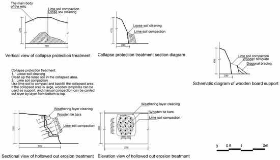
Figure 24.
Analysis of collapse treatment measures (image source: drawn by the author).
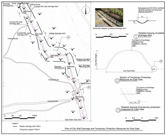
Figure 25.
Plan of city wall drainage and temporary protection measures for the East Gate (image source: drawn by the author).
The erosion protection treatment also involves cleaning the weathered layer, reinforcing it, and connecting it. (1) Small, soft tools are used to clean the weathered layer in the eroded area, which facilitates the compaction of the original soil. (2) For eroded areas with a wide range of erosion, researchers can use the method of inserting reinforcements to strengthen the connection. (3) Researchers arrange bamboo or wooden reinforcements in a mesh from top to bottom, depending on the size of the damaged area, to improve the adhesion between the site building and the original soil for compacting. Researchers compact the eroded area and backfill it with ash-rich soil. If the damaged area is large, one can use wooden templates as support and manually compact it from bottom to top.
Lastly, researchers treat trees and shrubs. (1) Firstly, researchers need to manually clean the trees and shrubs on the site and then treat the roots with drip herbicides. (2) Once the collapsed and eroded area has been protected, it is easy for local vegetation to survive. (3) Soil can be piled up to isolate the 3 m range outside the city wall to reduce the impact of agricultural cultivation on the city wall.
3.3.2. Focus: Impact of Plants on Walls
The investigation of the East Gate of the Ruins of the Imperial City of the Minyue Kingdom and the wall between the East Gate and the North Gate, combined with the results of archaeological excavations, indicates that erosion, collapse, and the growth of trees and shrubs are the main types of damage to the protected objects. To streamline the description and statistics of the damage, we have broken down the damage to the wall into sections, as detailed in the current situation drawings. Due to the variety of natural factors that destroyed the site, there are few damages caused by a single factor. Most of them are the result of the combined action of multiple factors or the result of the interaction of many factors.
The Ruins of the Imperial City of the Minyue Kingdom are full of tall trees and shrubs with well-developed root systems. Strips of natural vegetation primarily line the ruins. Human factors seriously disturb the inner side of the wild vegetation, which is close to farmland and woodland. From an ecotype classification standpoint, the Ruins of the Imperial City of the Minyue Kingdom recorded 56 plant species, including 16 trees, 14 shrubs, and 26 herbs. The herbaceous layer has a variety of plant species, while the shrub layer and the tree layer are relatively small. The original plant species in the tree layer have increased significantly because of the central terrace. The dominant species of wild trees are deep-rooted species such as pine, camphor, and fir with well-developed root systems; tea-stem bamboo and indigo bamboo are common wild shrubs in the Wuyi Mountain area with well-developed root systems and tolerance to high temperature and barrenness and are the dominant species in the shrub layer. Most of the plant species in the herbaceous layer are one- and two-year-old plants that are commonly found in the Wuyi Mountain area.
Among plant erosion, the destructive effect of plant roots at the edge of the city wall is the most significant. In the survey area, there are primarily seven species of plants that cause root-cleavage collapse. Table 3 displays the results of various plants’ root-cleavage effects. Among them, the largest number of plant species has no significant impact on the cause of platform edge collapse. The specific number reveals that Pinus tabuliformis Carrière lead the way in causing collapses, with Cinnamomum camphora (Linn) Presl, Cunninghamia lanceolata, Broussonetia papyrifera, Camellia oleifera, and Pseudosasa amabilis (McClure) P. C. Keng ex S. L. Chen & al. following closely behind, while Indocalamus tessellatus has the least significant impact. Based on the total area of collapse caused, it can be seen that Pinus tabuliformis Carrière is the most significant contributor to collapse area, followed by Cinnamomum camphora (Linn) Presl, Cunninghamia lanceolata, Broussonetia papyrifera, Camellia oleifera, and Pseudosasa amabilis (McClure) P. C. Keng ex S. L. Chen & al., while Indocalamus tessellatus is the least significant. Pinus tabuliformis Carrière, Cinnamomum camphora (Linn) Presl, and Cunninghamia lanceolata cause the most significant collapse erosion, and each tree species’ intensity ranking under these two erosion levels is nearly identical.
Table 3.
Statistics on cracks in the walls of the ruins of the Imperial City of the Minyue Kingdom.
Table 3 reveals that Pinus tabuliformis Carrière, Cinnamomum camphora (Linn) Presl, and Cunninghamia lanceolata accounted for the largest proportion of the total area, prompting a detailed investigation of these three plants. Table 4 presents the basic information of the survey sample, revealing significant variances among various indicators. After filtering out the data with incomplete measurement information, the number of samples of Pinus tabuliformis Carrière, Cinnamomum camphora (Linn) Presl, and Cunninghamia lanceolata was 90, 65, and 25, respectively. The researchers conducted statistical analysis on the data using SPSS 20.0 statistical analysis software, specifically examining the correlation between plant basal diameter, plant height, root length, root diameter, and collapse area. A total of 90 samples of Pinus tabuliformis Carrière demonstrate a significant correlation between each investigation factor and the crack area, with a correlation coefficient ranging from 0.285 to 0.823. Similarly, sixty-five samples of Cinnamomum camphora (Linn) Presl demonstrate a significant correlation between each investigation factor and the crack area. Correlated, the correlation coefficient is between 0.055 and 0.865; the number of samples of Cunninghamia lanceolata is small, 25 in total. Table 5 shows a significant correlation between the crack area and Cunninghamia lanceolata root length, basal diameter, and root diameter, with a correlation coefficient range of 0.185 to 0.893. The correlation between the various survey factors of plants and the collapse area is as follows: root diameter, followed by root length, base diameter, and plant height. The results revealed a significant relationship between the diameter of the root system in the crack and the collapse area, while the plant height did not significantly influence the size of the crack area.
Table 4.
The survey focuses on the basic parameters of the plants.
Table 5.
Investigate the correlation matrix between plant variables.
The root characteristics of the plants are the main factor in selecting suitable plants for the Ruins of the Imperial City of the Minyue Kingdom, according to on-site investigation and analysis of plant effects. The key to plant screening is to select plants with shallow roots within 40 cm and not very developed root systems so as to minimize the damage of plant roots to earthen sites. Local woody plants like Rhododendron and Nandina domestica Thunb., as well as herbaceous plants like Ophiopogon japonicus, serve as examples. The root systems of these plants are shallowly distributed, which can not only reduce the degree of wind and rain erosion of the ruins but also reduce the damage caused by plant root splitting.
In summary, the East Gate of the Ruins of the Imperial City of the Minyue Kingdom in Chengcun Village and the remains of the city wall between the East Gate and the North Gate are well preserved overall; the layout and structural characteristics of the East Gate remains are clear, and the outline and boundary of the city wall between the East Gate and the North Gate are clear. The protected object has a well-preserved relationship with the terrain and a well-preserved main building. However, collapse, erosion, and the growth of trees and shrubs have impacted the local soil remains, resulting in partially cracked or missing brick and stone remnants. Therefore, in the future, we should consider only displaying the outline and boundary of the East Gate, partially supplemented with glass windows. However, the East Gate and the city wall between the East Gate and the North Gate are in a natural open-air preservation state, lacking systematic display facilities. It is still necessary to improve the preservation conditions of the ruins through simulations and other means, giving full play to the display of the East Gate and the city wall between the East Gate and the North Gate in the Ruins of the Imperial City of the Minyue Kingdom in Chengcun Village, and slowing down the destruction of the ruins. In addition, the overall drainage around the North Gate ruins and the water gate is not smooth, which is extremely unfavorable for the preservation of the ruins. The lack of visiting flow lines will inevitably lead to the impact of visiting activities on the ruins.
4. Discussion: Practice of Site Display Project Design
Therefore, based on the investigation of the current situation, the geological survey, the analysis of the causes of damage, and the protection and display needs of the East Gate and the city wall between the East Gate and the North Gate of the Ruins of the Imperial City of the Minyue Kingdom in Chengcun Village of Wuyishan City, the following protection objectives were established: (1) Main building protection measures should be adopted for the entire protected object and the ruins to mitigate the impacts of collapse, erosion, and other causes of damage on the ruins. (2) We must ensure the safety of the city wall by clearing vegetation such as trees and shrubs that threaten the stability of the structure. (3) By presenting the East Gate ruins accurately and comprehensively, we can explain the fundamental shape, construction, and historical details of the East Gate, enhancing the understanding of its function as the primary entryway to the Ruins of the Imperial City of the Minyue Kingdom in Chengcun Village of Wuyishan City. (4) The current situation of waterlogging in the ruins can be improved by organizing drainage of the East Gate and the city wall between the East Gate and the North Gate. This project aims to protect and display the East City Gate and the city wall from the East City Gate to the North City Gate, encompassing the aspects of both repair and protection. The scope of this project is to protect the city wall from the East City Gate to the North City Gate and improve the display facilities, with an area of 16,200 square meters.
4.1. Protection and Treatment of Collapse
For collapsed sites and relics, the original soil is compacted for reinforcement and protection. Relevant measures include cleaning the loose soil in the collapsed areas and compacting the ash soil. The research team compacted the collapsed area and backfilled it with ash soil. If the collapse damage is significant, we can use wooden formwork as support and manually compact the layers from bottom to top. Depending on the surrounding terrain and slope, we can treat the collapsed area by tamping it with 37 layers of ash soil. We can manually tamp the ash soil construction, measuring each loose soil part at 300 mm (9 inches) before and 150 mm (4.5 inches) after compaction until we have filled and compacted the collapsed area. The preparation requirement for 37 layers of ash soil is a lime-to-soil ratio of 3:7. It is recommended to use quicklime burned using grass and wood after processing, and coal-burned lime should not be used or used with caution. The soil used should be pure and uncontaminated. It should contain fine sand and coarse sand with particle sizes between 1 and 3 mm, a small amount of coarse sand with a particle size of about 5 mm (no more than 10%), and small stones no larger than 10 mm (less than 0.5% by volume); the sand content in the mud should be less than 30%.
4.2. Protection and Treatment of Erosion
The erosion damage to the protected object is primarily located in the middle of the ruins’ façade. The research team should employ the following protection procedures to treat the damage. (1) Cleaning of the weathering layer: Small, soft tools should be used to clean the weathering layer in the erosion area to facilitate the compaction of the original soil. (2) Insertion and compaction: The research team can use insertion and connection methods for erosion areas that span a large range. We can arrange bamboo or wooden bars in a mesh from top to bottom, depending on the size of the problematic area, to enhance the adhesion between the ruins and the original soil for compaction. The research team should compact the erosion area and backfill it with gray soil. If the range of damage is large, we can use wooden templates as supports and manually compact the soil from bottom to top. Layered tamping with 37 gray soil layers can be used to treat the eroded area, depending on the surrounding terrain and slope. The loose soil treatment measures are identical to those described in Section 4.1.
4.3. Treatment of Trees and Shrubs
Initially, the research team should refrain from treating herbaceous plants with shallow roots and a low height that grow on non-unstable structures and do not impact future construction, following the principle of minimal intervention. For trees and shrubs on the site, stems and leaves should be cleaned manually, and the roots should be treated with drip herbicides. Once the herbicides have been fully absorbed, the research team should regularly observe the plants’ condition and record their appearance characteristics, including their wilting and death times. The research team should check the effect of the treatment on a weekly basis. After the vegetation is completely dead, the dead roots and the parts that have rotted and softened in the soil should be reinforced by filling the soil to ensure the strength of the site building, and the cleaned area should be replanted with high-survival vegetation, such as Zoysia japonica and Bigleaf Oil Grass, to avoid the formation of new surface water infiltration channels that affect the safety of the site. Secondly, for collapsed and eroded areas, it is necessary to replant high-survival vegetation, such as Zoysia japonica and Bigleaf Oil Grass, after protection. In addition, there is farmland relatively close to the city wall. It is recommended that the construction unit coordinate with relevant units to pile up soil to isolate the area within 3 m outside the city wall to reduce the impact of agricultural cultivation on the city wall.
4.4. The East Gate Exhibition Project’s Design
Renovations are underway on the east side of the East Gate to enhance the display of the protection and exhibition project (Figure 26). We set up a small, hard-paved square on the east side of the East Gate for tourists to gather and disperse. A wooden platform connects to the square. We set up a water-friendly wooden plank road in a lotus pond and renovated it. Lotus dominates the pond, with water plantains, reeds, loosestrife, and other plants following closely behind. Based on the results of the archaeological excavation of the East Gate ruins and the requirement for a protective display, the volume of the East Gate protection building is slightly larger than the original gate site. A steel structure and pile foundation treatment are used for the main building, supplemented by low-e hollow glass with automatic sunshade curtains and other modern building materials to prevent ultraviolet rays from affecting the ruins. We painted the exterior with an imitation of yellow rammed earth. The pile foundation was used for construction. To minimize disturbance to the ruins, the design plan provides directions for excavation or backfilling in areas where archaeological work has confirmed the absence of underground remains. A hip roof that imitates the Han Dynasty’s opposing mother-and-child towers with corridors was chosen for the exhibition design. It is necessary to the cracks and supplement the missing bricks in the original simple display.
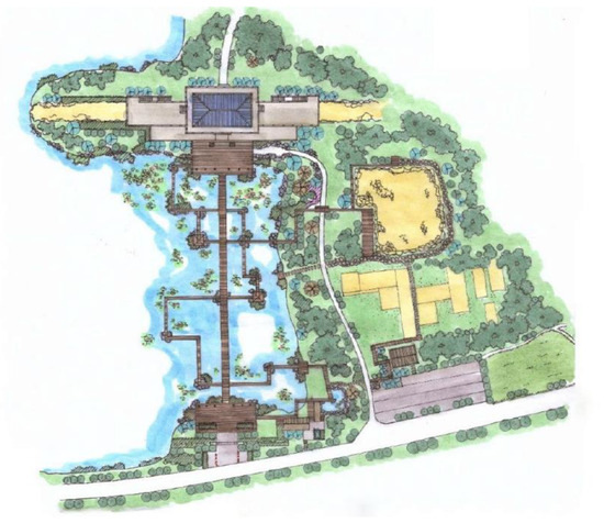
Figure 26.
Environmental improvement of the lotus pond east of the East City Gate (image source: provided by the excavation team for the Ruins of the Imperial City of the Minyue Kingdom).
The theme of the scheme is the characteristic architecture of the Han Dynasty, known as Quelou (Figure 27). The Han Dynasty divided Quelou into three types to distinguish among ranks. The princes and officials with more than 2000 stones used a pair of two-out Ques, which consisted of a main Que and a sub-Que. From the Qin and Han Dynasties to the Wei and Jin Dynasties, there was a period of rapid development of Que in the city. During this period, double, and triple Que appeared and coexisted with a single Que. During this period, the double Que form emerged on both sides of the city gate, coexisting with the isolated terraces outside the city gate, with no strict regulations governing its use. Mr. Liu Dunzhen noted in “History of Ancient Chinese Architecture” that another characteristic of group architecture in the Han Dynasty was the evolution of a tradition that began in the Spring and Autumn Period (Figure 27, Figure 28 and Figure 29). This tradition involved building Que outside palaces, mausoleums, temples, and tombs, thereby enhancing the solemnity of the entire architectural group. One form of Que involved constructing a gatehouse or building between the left and right Que, thereby uniting them into a single entity.
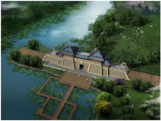
Figure 27.
Rendering of the design scheme for the East City Gate Relic Exhibition Project (image source: provided by the excavation team for the Ruins of the Imperial City of the Minyue Kingdom).
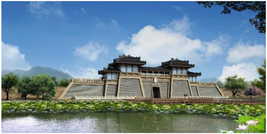
Figure 28.
Rendering of the design scheme for the East City Gate Relic Exhibition Project (image source: provided by the excavation team for the Ruins of the Imperial City of the Minyue Kingdom).
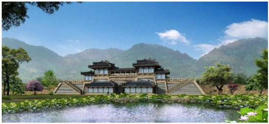
Figure 29.
Rendering of the design scheme for the East City Gate Relic Exhibition Project (image source: provided by the excavation team for the Ruins of the Imperial City of the Minyue Kingdom).
Steel, low-e hollow glass with automatic sunshades, and other modern materials are used to bolster the building and prevent ultraviolet rays from damaging the ruins. The exterior is painted with yellow paint to imitate rammed earth and truly and completely protect and display the remains and historical features of the East Gate ruins. The design of the building positions it as an inaccessible city platform due to the constraints of its form and location. We arranged the main building 2.2 m from the outer edge of the ruins to safeguard the building’s exterior wall and prevent it from coming into contact with the city gate. Two opposing hip-and-gable roofs, one double-eaved and the other single-eaved, form the main building, with a corridor connecting the two mother Ques. A trapezoidal steel frame was constructed along the ruins’ slope under the corridor, with steel shutters on the outside and glass inlaid inside. The wall retracts slightly from the bottom to the top, creating a slope. To protect the guardhouse ruins, a single-eaved, hip-roofed building was built on the back of the main building. The city platform retains its original function by leaving a hole in the middle for people to pass through. The main building platform forms the shape of the 20-m-long city walls on both sides. Tourists can climb up to the platform for a panoramic view, with horse paths arranged along the edge of the city wall.
4.5. Comparative Analysis with Similar Sites
By comparing the wall protection and display projects of the Ruins of the Imperial City of the Minyue Kingdom with those of the archaeological Ruins of Liangzhu City, the National Archaeological Site Park of the State of Lu in Qufu, the Archaeological Site Park of Zhaowang City, the Archaeological Site Park of He Lv City, and the Archaeological Site Park of Tong Wan City, we can extract lessons from many perspectives.
(1) Comparison of protective technologies and methods: (a) Stability enhancement: All sites have adopted modern scientific and technological means for protecting their walls, such as the 3D laser scanning and digital modeling used in the Archaeological Ruins of Liangzhu City to analyze the wall data and provide a scientific basis for subsequent reinforcement and restoration. (b) Waterproofing and anti-erosion measures: Waterproof materials and anti-erosion measures have been adopted in both Tong Wan City and He Lv City to protect the wall structures and reduce the impact of environmental factors on the sites. This experience can effectively extend a wall’s service life.
(2) Display methods and public participation: (a) Digital display and interactive experience: Digital technology and virtual reality are used in the archaeological ruins of Liangzhu City to display the history and culture of the site, attracting a large number of tourists to participate, which provides a helpful reference for the display of the ruins of the Imperial City of the Minyue Kingdom. (b) Education and community participation: In Qufu, the ancient city of Lu State uses community participation and education projects to help local residents understand the value of cultural relics and increase their awareness of their protection. This strategy promotes the active participation and support of the public.
(3) Safety and management: (a) Building a security system: A monitoring system has been constructed around the city wall in Zhaowangcheng Archaeological Site Park to ensure the site’s safety, monitor it closely, and prevent human damage. This system is also an important aspect from which to learn when applying such strategies to other sites. (b) Management committee and expert consultation: To ensure professional guidance in the protection and display process, a management committee comprising archaeologists, architects, and local government members was established for He Lv City. This committee serves as a good investment model for the management of other sites.
(4) Combination of government and social funds: The protection projects for most heritage parks, such as the Archaeological Ruins of Liangzhu City and Tong Wan City, have received policy support and financial guarantees, especially in the form of support from local governments, demonstrating the important role of the government in cultural heritage protection. Similar models can provide references for managing the ruins of the Imperial City of the Minyue Kingdom.
(5) Principle of sustainability: The design of the display of the Archaeological Ruins of Liangzhu City and Tong Wan adheres to the principle of sustainable development, using natural materials and low-impact construction to minimize the negative impact on the ruins. This approach can provide a reference for the future maintenance of other sites.
(6) Regular evaluation mechanism: For example, a long-term monitoring and evaluation mechanism was adopted in He Lv to regularly check the structural stability and environmental impact of the city wall. This mechanism can be used to detect problems in a timely manner, take effective measures, and ensure the effectiveness of protection work.
While the protection and display projects for the city gates and city walls of various archaeological sites exhibit unique characteristics, they share common experiences in terms of protection technology, public participation, management mechanisms, financial support, and sustainable development. These experiences can be utilized in the Ruins of the Imperial City of the Minyue Kingdom to tailor measures and methods that align with its unique characteristics. This approach will facilitate a more scientific and reasonable implementation of the protection and display project for its city walls, thereby effectively safeguarding and showcasing its cultural heritage.
4.6. Long-Term Sustainability Planning
As an important part of cultural heritage, the Ruins of the Imperial City of the Minyue Kingdom in China face several challenges in terms of conservation measures, especially in terms of long-term planning, ongoing maintenance, and monitoring.
(1) Lack of long-term protection planning: (a) Analysis of the current situation: Currently, many protection measures are short-term in nature and do not form an effective long-term protection plan. This may result in a lack of systematic and forward-looking site protection, as well as a failure to effectively respond to future challenges. (b) Suggested solutions: A comprehensive long-term protection plan should be developed, and a comprehensive protection plan that encompasses archaeology, environment, art, and community participation while clearly defining both short-term and long-term goals and measures should be established. (c) Regular evaluation and updating: It is crucial to regularly evaluate, update, and adjust the protection plan based on new research findings and changes in the external environment.
(2) Lack of continuous maintenance and monitoring: (a) Analysis of the current situation: After the completion of excavation and protection work, the site’s continuous maintenance and monitoring may encounter issues due to a lack of funds and personnel, which could lead to inadequate attention to the site’s condition. (b) Suggested solutions: A regular monitoring system should be established by using modern technology, such as sensors and drones, for regular monitoring to track the site’s physical condition and environmental impact. (c) Participation of professional teams: A professional team for maintenance and monitoring should be established to ensure that there is sufficient professional support in site management.
(3) Response to the challenges of climate change: (a) Analysis of the current situation: Temperature changes, changes in precipitation patterns, and extreme weather events may reflect the impact of climate change on the Minyue Royal City Ruins, potentially causing damage to the ruins’ structure and materials. (b) Suggested solutions: Through climate-adaptive design, the impact of climate change on the protection and display of the ruins should be considered, and adaptive measures such as improving drainage systems and setting up sunshade facilities should be taken to protect the ruins from extreme weather. (c) Climate change research: Research on the impact of climate change on cultural heritage should be conducted.
(4) Increased pressure due to tourism: (a) Analysis of the current situation: As tourism gains popularity, an increase in the number of tourists could potentially cause physical damage and psychological fatigue in the ruins, thereby accelerating their wear and tear. (b) Suggested solutions: Through visitor management and education, the pressure on the ruins should be reduced by implementing strategies such as tourist flow control, time-sharing reservations, and raising tourists’ awareness of heritage protection. (c) Sustainable tourism development: Small-scale, culturally focused tourism projects should be created to ensure a balance between tourism activities and heritage protection.
(5) Public participation and awareness: (a) Analysis of the current situation: The public’s participation in and awareness of cultural heritage protection may be insufficient, making it difficult for protective measures to gain effective social support and implementation. (b) Suggested solutions: Through a community participation project, local residents’ awareness of and participation in heritage protection by organizing community events, educational lectures, and volunteer activities should be encouraged. (c) Digital platform and interactive display: Digital technology should be used to create interactive displays and online educational resources to enhance public interest and responsibility for the heritage site.
To ensure that the protection of the Ruins of the Imperial City of the Minyue Kingdom in China can meet future challenges, it is necessary to strengthen long-term planning and community participation in protective measures, establish a stable monitoring and maintenance mechanism, and develop specific strategies for coping with climate change and pressure due to tourism. This comprehensive approach can lay a solid foundation for the sustainable development of the site.
4.7. Human Activities’ Impacts Require Continued Attention
Human activities, especially the conflicts between urban and rural construction, economic development, rural revitalization, and heritage protection, are indeed important factors leading to the degradation of the Ruins of the Imperial City of the Minyue Kingdom.
(1) Construction in urban and rural areas: (a) Urban expansion: With the acceleration of urbanization and the construction of Wuyi New District, the Ruins of the Imperial City of the Minyue Kingdom are located in the core area of Wuyi New District. The construction of high-speed railways, highways, light rails, and expressways in the surrounding areas has increased the demand for urban development, resulting in rapid urban and rural expansion. In many cases, developers and local governments often ignore the existence of ruins in order to meet the needs of urban infrastructure construction. The construction of new residential areas and transportation facilities around the Ruins of the Imperial City of the Minyue Kingdom may cause direct coverage or physical damage to the ruins. (b) Insufficient archaeological investigation: In the process of urban expansion, many development projects have not carried out sufficient archaeological investigations, resulting in the destruction of historical sites without evaluation. Because the Ruins of the Imperial City of the Minyue Kingdom are located in a key development area, urban construction often gives priority to economic benefits, while the protection of cultural heritage is often placed in a secondary position.
(2) Economic development: (a) Resource development and environmental impact: In order to promote economic development, various resource development activities (such as excessive reclamation of tea mountains and farmland transformation) have had a profound impact on the surrounding environment. The development of many industries is accompanied by the development of natural resources, and these activities often cause irreversible damage to the Ruins of the Imperial City of the Minyue Kingdom and its surrounding ecological environment. (b) Industrial waste and pollution: With the rapid development of urban and rural economies, the discharge of industrial waste and agricultural fertilizers has increased, leading to soil and water pollution. This pollution not only affects the lives of residents, but also corrodes the soil and building materials of cultural relics, thereby affecting the ruins’ stability and integrity.
(3) Impacts of rural revitalization: (a) Land use change: Rural revitalization policies have promoted the redevelopment of rural land, which involves agricultural transformation and facility construction on land around heritage sites. In some cases, rural revitalization may encourage the development of tourism, but if there is a lack of reasonable planning and management, it will lead to overdevelopment and damage the original heritage environment. (b) Cultural heritage and economic pressure: The goal of rural revitalization often involves modernizing the rural economy, a process that could potentially result in the erasure of traditional culture and customs. When rural economic activities are at the expense of cultural heritage, this will not only affect the protection of the heritage but also weaken the local community’s sense of identity with the cultural heritage.
(4) Conflicts regarding heritage protection: (a) Conflict of interests: In the context of urban and rural construction and economic development, heritage protection often faces pressure from development and commercial interests. Local governments and developers usually promote economic growth, while cultural protection organizations try to maintain the integrity of the site. This conflict of interest often puts cultural heritage protection at a disadvantage and makes it difficult to receive the attention and support it deserves. (b) Insufficient enforcement of laws and regulations: Although both the national and local governments have laws and regulations on heritage protection, in actual implementation, many laws and regulations have not been effectively implemented due to insufficient resources, poor supervision, and local interests. The pressure of development complicates the proper protection of heritage sites.
In summary, human activities have a profound impact on the degradation of the ancient city site, and the conflicts brought about by urban and rural construction, economic development, and rural revitalization have exacerbated its vulnerability. While promoting economic and social development, we must strengthen the attention paid to cultural heritage and further improve the protection mechanism to achieve a balance between heritage protection and economic and social development. Only through multi-party cooperation, reasonable planning, and policy implementation can we better protect this precious cultural site and preserve historical memory for future generations.
5. Conclusions
This study utilized the Ruins of the Imperial City of the Minyue Kingdom (Han Dynasty Ruins in Chengcun Village of Wuyishan City) as a case study to investigate the practices of archaeological excavation, protection, and display engineering design. The study found the following. (1) Geological survey results: The site’s interior is a hilly plateau; the terrain is suitable for arranging large palace buildings; the foundation soil layer is stable and uniform, and it is suitable for project construction. (2) Site preservation exploration results: (a) East Gate Site: Only the ground portion of the towers, which were rammed earth platforms on both sides of the East Gate, remain. The gate is 4.5 m wide. The north and south guard rooms are located on the inner side of the East Gate. On the ground, there are a large number of collapsed tiles and charcoal burning marks from the Han Dynasty. (b) East City Wall Site: The wall is 6.3 m high, mainly rammed earth, with 47 layers. Most of the interior and exterior wall skins have fallen off. Tree and shrub growth, erosion, and partial collapse are problems. (3) Causes of damage and response strategies: The primary damage is caused by erosion, collapse, and the growth of trees and shrubs. The causes include rainwater erosion, plant impacts, natural factors leading to damage to masonry materials, and human activities. The response strategies include treating collapsed and eroded areas, clearing trees and shrubs, planting vegetation that easily survives, and improving drainage. (4) Site display project design practice: We designed a protection and exhibition project for the East Gate, which involved establishing a square, a wooden platform, a hydrophilic wooden plank road, and a protective building. We utilized steel structures and pile foundation treatments, employed modern building materials to shield the site from UV rays, and emulated the architectural style of the Han Dynasty.
Currently, numerous cultural heritage sites and architectural sites await further excavation. The Ruins of the Imperial City of the Minyue Kingdom provide other regions with technical references for archaeological excavations under complex terrain or special geological conditions, particularly for archaeological sites with similar environmental conditions. At the same time, such a large-scale site excavation project demonstrates the importance of multidisciplinary cooperation between archaeology, geology, biology, architecture, and excavation. This multidisciplinary collaboration model can provide ideas for archaeological projects in other countries, particularly the ruins of ancient capitals, prompting them to break down disciplinary barriers and integrate professional knowledge from different fields in order to more comprehensively understand the formation process, historical background, and cultural connotation of the site.
Author Contributions
Conceptualization, S.Z. and L.Z. (Lei Zhang); methodology, S.Z. and L.Z. (Lei Zhang); software, S.Z. and L.Z. (Lei Zhang); validation, S.Z. and L.Z. (Lei Zhang); formal analysis, S.Z., L.Z. (Lei Zhang), and Y.C.; investigation, S.Z. and L.Z. (Lei Zhang); resources, S.Z. and L.Z. (Lei Zhang); data curation, S.Z. and L.Z. (Lei Zhang); writing—original draft preparation, L.Z. (Lei Zhang) and Y.C.; writing—review and editing, L.Z. (Liang Zheng), J.Z. and N.L.; visualization, L.Z. (Liang Zheng), J.Z. and N.L.; supervision, L.Z. (Lei Zhang) and Y.C.; project administration, L.Z. (Lei Zhang); funding acquisition, L.Z. (Lei Zhang). All authors have read and agreed to the published version of the manuscript.
Funding
This research was funded by the Fujian Provincial Social Science Fund Project “Research on the Spatial Morphology of Ancient Capitals in the Minyue Region” (grant number: FJ2022C079), the Fujian Provincial Education and Research Project for Young and Middle-aged Teachers (Science and Technology) “Research on Spatial Protection and Revitalization Strategies of Traditional Villages in Northern Fujian with Tourism as the Guide” (grant number: JAT190768), the Fujian Provincial First-Class Undergraduate Course “Architectural Surveying” (grant number: SJYLKC202111), and the Ministry of Education Industry–University Cooperation and Collaborative Education Project “Construction and Practice of First-Class Courses in Information-Based Surveying of Architectural Heritage Based on PIE Software Support” (grant number: 220902313272006). Dr. Lei Zhang is the leader of the above projects. Other people were also involved in the research. At the same time, this study was supported by the Key Laboratory of Smart Town Construction Technology in Hilly and Mountainous Areas of Fujian Universities.
Institutional Review Board Statement
Not applicable.
Informed Consent Statement
Not applicable.
Data Availability Statement
The datasets used and analyzed during the current study are available from the corresponding author upon reasonable request.
Conflicts of Interest
The authors declare no conflicts of interest.
References
- Mount Wuyi. Available online: https://whc.unesco.org/en/list/911/ (accessed on 7 August 2024).
- Ruins of the Imperial City of the Minyue Kingdom. Available online: https://www.fujian.gov.cn/english/services/travel/placetovisit/201701/t20170125_1869536.htm (accessed on 7 August 2024).
- Lombardo, V.; Karatas, T.; Gulmini, M.; Guidorzi, L.; Angelici, D. Transdisciplinary approach to archaeological investigations in a semantic web perspective. Semant. Web 2023, 14, 361–383. [Google Scholar] [CrossRef]
- Depauw, M.; Dzierzbicka, D. Modern Scholars at Work in a Digital and Multidisciplinary Setting. In A Companion to Greco-Roman and Late Antique Egypt; John Wiley & Sons, Inc.: Hoboken, NJ, USA, 2019; pp. 15–31. [Google Scholar] [CrossRef]
- Hardesty, D.L.; Little, B.J. Assessing Site Significance: A Guide for Archaeologists and Historians; Rowman: Altamira, Spain, 2009. [Google Scholar]
- Jokilehto, J. A History of Architectural Conservation; Routledge: London, UK, 2017. [Google Scholar]
- Matini, M.R.; Andaroodi, E.; Ono, K. A 3D approach to reconstitution of the adobe citadel of Bam after earthquake: A complementary interpretation of architectural heritage knowledge, aerial photogrammetry, and heterogeneous data. Int. J. Archit. Herit. 2019, 13, 600–618. [Google Scholar] [CrossRef]
- Cressey, P.J.; Stephens, J.F. The city-site approach to urban archaeology. In Archaeology of Urban America; Academic Press: Cambridge, MA, USA, 1982; pp. 41–61. [Google Scholar] [CrossRef]
- Dyson, S.L. Rome: A Living Portrait of an Ancient City; JHU Press: Baltimore, MD, USA, 2010. [Google Scholar]
- Carver, M. Archaeological Investigation; Routledge: London, UK, 2013. [Google Scholar]
- Drewett, P. Field Archaeology: An Introduction; Routledge: London, UK, 2011. [Google Scholar]
- O’Connell, J.F. Alyawara site structure and its archaeological implications. Am. Antiq. 1987, 52, 74–108. [Google Scholar] [CrossRef]
- Raban, A. The city walls of Straton’s Tower: Some new archaeological data. Bull. Am. Sch. Orient. Res. 1987, 268, 71–88. [Google Scholar] [CrossRef]
- Özyigit, Ö. The city walls of Phokaia. Rev. Des Études Anciennes 1994, 96, 77–109. [Google Scholar] [CrossRef]
- Pfälzner, P. Archaeological investigations in the royal palace of Qatna. In Bonacossi, Morandi (Hrsg.): Urban and natural landscapes of an ancient Syrian capital, Proceedings of the International Conference held in Udine, Italy, 9–11 December 2004; Studi Archeologici su Quatna I: Udine, Italy, 2007; pp. 29–64. Available online: https://archiv.ub.uni-heidelberg.de/propylaeumdok/volltexte/2011/891 (accessed on 7 August 2024).
- Palyvou, C.; Papadopolous, J.K.; Leventhal, R.M. Architecture and archaeology: The Minoan palaces in the twenty-first century. Theory Pract. Mediterr. Archaeol. Old World New World Perspect. 2003, 1, 205. [Google Scholar]
- Einhorn, T. Israeli law, Jewish law and the archaeological excavation of tombs. Int. J. Cult. Prop. 1997, 6, 47–80. [Google Scholar] [CrossRef]
- Lerici, C.M. Methods used in the archaeological prospecting of Etruscan tombs. Stud. Conserv. 1961, 6, 1–8. [Google Scholar] [CrossRef]
- Demas, M. Planning for Conservation and Management of Archaeological Sites. In Proceedings of the Management Planning for Archaeological Sites: An International Workshop Organized by the Getty Conservation Institute and Loyola Marymount University, Corinth, Greece, 19–22 May 2000. [Google Scholar]
- Ismail, B. Restoration of archaeological establishments from an engineering perspective. Int. J. Adv. Eng. Civ. Res. 2021, 1, 1–16. [Google Scholar] [CrossRef]
- Zhan, X.; Zhou, M.; Zhang, Q.; Yeh, H.Y. Intestinal parasites from Hubei archaeological sites of early China (5th century BCE to 3rd century CE). J. Archaeol. Sci. Rep. 2024, 58, 104734. [Google Scholar] [CrossRef]
- Lupia, M.; Gagliardi, G.; Cario, G.; Cicchello Gaccio, F.; D’Angelo, V.; Folino, P. A smart system for environmental parameter monitoring in underwater archaeological sites. Electronics 2023, 12, 2918. [Google Scholar] [CrossRef]
- Adamopoulos, E.; Rinaudo, F.; Ardissono, L. A critical comparison of 3D digitization techniques for heritage objects. ISPRS Int. J. Geo-Inf. 2020, 10, 10. [Google Scholar] [CrossRef]
- Kantaros, A.; Ganetsos, T.; Petrescu, F.I.T. Three-Dimensional Printing and 3D Scanning: Emerging Technologies Exhibiting High Potential in the Field of Cultural Heritage. Appl. Sci. 2023, 13, 4777. [Google Scholar] [CrossRef]
- Kantaros, A.; Soulis, E.; Alysandratou, E. Digitization of Ancient Artefacts and Fabrication of Sustainable 3D-Printed Replicas for Intended Use by Visitors with Disabilities: The Case of Piraeus Archaeological Museum. Sustainability 2023, 15, 12689. [Google Scholar] [CrossRef]
- Angheluță, L.M.; Popovici, A.I.; Ratoiu, L.C. A Web-Based Platform for 3D Visualization of Multimodal Imaging Data in Cultural Heritage Asset Documentation. Heritage 2023, 6, 7381–7399. [Google Scholar] [CrossRef]
- Chu, D.; Huang, C.; Lin, F. Spatio-temporal evolution characteristics of cultural heritage sites and their relationship with natural and cultural environment in the northern Fujian, China. Herit. Sci. 2024, 12, 210. [Google Scholar] [CrossRef]
- Xue, Q.; Wang, Z. A discussion on some related problems of Minyue culture. J. Fujian Normal Univ. (Philos. Soc. Sci. Ed.) 2007, 2, 36–42. (In Chinese) [Google Scholar]
- Zhao, C. On the early features and culture of Minyue ethnic group. J. Jishou Univ. (Soc. Sci.) 2012, 33, 41–48. (In Chinese) [Google Scholar]
- Milburn, O.R. The towers of Yue. Acta Orient. 2010, 71, 28. [Google Scholar] [CrossRef]
Disclaimer/Publisher’s Note: The statements, opinions and data contained in all publications are solely those of the individual author(s) and contributor(s) and not of MDPI and/or the editor(s). MDPI and/or the editor(s) disclaim responsibility for any injury to people or property resulting from any ideas, methods, instructions or products referred to in the content. |
© 2024 by the authors. Licensee MDPI, Basel, Switzerland. This article is an open access article distributed under the terms and conditions of the Creative Commons Attribution (CC BY) license (https://creativecommons.org/licenses/by/4.0/).