Abstract
The interconnection between the objectives of territorial development and those of the agro-ecological transition highlights the value of past knowledge in the sustainable management of resources and agro-ecological systems. However, the lack of data creates difficulties for retrospection in rural areas. This paper contributes to the search for such knowledge from the past by developing an interactive methodology capable of combining heterogeneous information sources with the activation of local collective memory. Its effectiveness is based on ensuring the interoperability of information and communication in an environment simultaneously shaped by geoinformatics and 3D geovisualisations. This virtual environment fostered participation and interactivity, supported by representations of the paleo-landscape (Ottoman period). Furthermore, synergies were achieved between information sources, which were integrated into local spatial systems. The application example involved identifying a rice field that existed between the 15th and 19th centuries in Thessaly, Greece. It is an interesting case because the research results indicated that the location and organisation of the crop, combined with the spatio-temporal coordination required, ensured the sustainable use of natural resources. The interplay between information and communication facilitated community participation and the activation of its collective memory as an information source that enriched the search itself and local intelligence.
1. Introduction
Linking sustainable development to a competitiveness based on distinctiveness, in combination with the move towards agro-ecological transition, leads rural territorial areas to re-approach their historical space and heritage [1,2,3]. It represents, in essence, an attempt to interpret the past in terms of future stakes, which assigns a new dimension and a new role to intangible heritage. The modern crisis of social and production systems better explains the search for new traditional values [4] and the broadening scope of the heritage of knowledge. On the one hand, a more objective and functional approach to heritage is emerging, since it tends to acquire a developmental function and the status of a resource in the context of territorial development, while no longer being an obstacle to modernisation [5,6]. One the other hand, as a result of climate change and resource overexploitation, it is accepted that heritage offers, beyond idealistic and timeless values, knowledge and practices for the “soft management” of natural resources [4]. Important fields provide knowledge and experience regarding the equilibrium of the Mediterranean agro-silvo-pastoral system, crop rotation and the proper management of water [7]. In view of these implications, local communities are realising that the way in which their ancestors appropriated natural resources in the past provides knowledge today about the agro-ecological transition. They understand that this intangible heritage can, as an element of community intelligence [8], respond locally to sustainability goals set at the global level [9,10]. In other words, it can respond to the sustainable management and efficient use of natural resources, improving nutrition, promoting sustainable agricultural production and reversing soil degradation and the loss of biodiversity [11]. Recognising the value of heritage reintegrates it into local community intelligence in the form of knowledge [12], raising the issues of its identification and integration in local territorial and agro-ecological planning.
In order to take advantage of this new role of heritage, local communities (farmers, breeders, employees, pensioners) have already started emphasising elements and knowledge from the past by activating collective memory [6]. This knowledge constitutes part of community intelligence [13]. The difficulties faced in rural areas stem from a lack of information and clues, since the morphological elements that characterise the space (landscape etc.) cannot remain unchanged over time [3,14,15]. This deterioration depends on the duration and intensity of the agricultural production model and its impact on the landscape. On the basis of this model, past knowledge about environmentally friendly farming (i.e., sustainable use of natural resources) and production systems was devalued and abandoned, considered an obstacle to productivity [7]. The past systems were extensive, with almost no environmental impact, and contributed to the proper management of natural resources. This development was reinforced by advice coming from the private rather than the public sector [16]. The devaluation of living heritage extended to the social sector, covering much of Mediterranean life (Mediterranean diet, etc.), and was indirectly reproduced by the public education system itself [17,18]. Furthermore, retrospection becomes more difficult when inherited knowledge concerns a farming system and agricultural landscape that no longer exist. It follows from the above that identifying such knowledge is often faced with scarce and heterogeneous information sources (official statistics, travellers’ accounts, collective memory). These difficulties are exacerbated when the need to link heritage with the place and its resources requires their dual immaterial and material natures to correspond [4]. Although this cognitive heritage is not always visible, it is detectable when conveyed by local collective memory [2,19]. This means that the participation of local actors in this detection process is decisive. The issue which therefore arises concerns how this memory is activated. If participation is necessary for the identification and interpretation of heritage, then the activation of local collective memory requires the representation of its old reference landscape [2,3,20,21], since it no longer exists.
Applications to date show that the combination of resources, methods, tools and a 3D virtual environment (3D virtual worlds) can contribute to the collaborative creation of knowledge by actors [22,23]. Advances in geoinformatics and the integration of 3D interactive representations [2] succeed in harnessing the spatial dimension of information, in order to reconstruct the landscape, by using the concept of a local spatial system [24,25]. In this process, GIS is a powerful tool to collect, process and visualise geographic information [26,27,28]. The science of geoinformatics, by comparing satellite and aerial images of different time periods, helps to identify changes in land use and land cover [29,30,31]. Highlighting the geometric characteristics of information (position, shape, size, proximity to road/river networks, etc.) in such a virtual environment is a precursor to approaching the semantic dimension of information, i.e., the spatial and functional dimension of heritage. This approach requires the spatial projection of intangible and material elements, followed by their integration within local spatial subsystems [3,4,25]. However, it has been observed in recent decades that geoinformatics tools and techniques are increasingly being applied by researchers in the management and analysis of information related to material rather than intangible heritage [32,33]. This gap can be addressed through the use of geoinformatic representations to activate visual-spatial intelligence as a component of cognitive intelligence [34]. These representations can be very accurate if old aerial photographs are used (photos from 1945, taken by the American Air force). By allowing the positions of different objects to be visualised, 3D-GIS can use the ability of local collective memory actors, on the one hand, to easily perceive shapes, objects and visual information that they can interpret and recall and, on the other hand, to create their own spatial representations based on the oral description of events and images that they were provided [35]. Actors benefit from visualisation, as it enables the invisible to be seen by transforming abstract data into visual representations [36], such as the reconstruction of historical landscapes. However, the contribution of interaction to the synergies between heterogeneous sources and types of information, including local collective memory, and to the creation of collaborative knowledge depends on the interoperability of information and communication among local actors themselves as well as with researchers [37,38,39]. As several studies note, 3D participatory GIS (3D PGIS) can support interoperability through the use of high-resolution satellite imagery, participatory rural appraisal (PRA) methods and the creation of interactive 3D environments [2,40]. These interactive environments can contribute to the generation of new information and meta-information [3] and highlight the semantic property of information: landscape intelligence and position functionality within spatial systems. In this framework, the majority of studies employing 3D PGIS are limited to the objective of highlighting and preserving objects of cultural value (material elements) in the territory [41,42,43]. However, few studies have focused on the spatial anchoring of the material and immaterial elements of a resource because this requires the existence of spatial data as well as a particular combination of sources, information and technical tools enriched by local collective memory [44]. Researchers are called upon to address a methodological issue facing any area that has more oral and knowledge information than topographical information.
Making use of the advances in this field, this paper develops a retrospection methodology supporting the active participation of the local community (farmers, breeders, employees, pensioners, etc.) through 3D geovisualisation (GIS, spatial analysis, photo interpretation…). This methodology proposes an environment which combines information and its various sources and functions as a facilitator in the activation of collective memory, which is thus transformed into an additional source of information. The question addressed by this methodology is the extent to which interactivity, as a product of participation and the interoperability of information and communication, can help identify and interpret knowledge, landscapes and spatial systems that have disappeared. In other words, information is “spatialised” and depicted dynamically and is thus incorporated into the process of communication between actors and the research team. The application example involved the identification of a paddy field cultivated between the 16th and 19th centuries in the plain of Thessaly, in the area of Farsala (during the Ottoman period). It is an interesting case in which the production process and the efficient use of natural resources were perfectly combined in the siting and organisation of a crop that is demanding in terms of spatio-temporal coordination (ensuring production based on water availability, the needs of areas downstream and the contribution of crop rotation to soil fertility) [45,46]. Identifying the paddy field, because of the aforementioned spatial characteristics, presented a challenge to the study in that it could help highlight inherited knowledge regarding agro-ecological management (focusing on the proper use of water). This knowledge is interesting since its rationale is rooted in nature before the impacts of intensive agriculture, and it stems from spatial, as well as ecological, analysis. This knowledge can help interdisciplinary approaches overcome the limits of ecology or of overlooking the environment and the laws of spatial organisation [47]. Lastly, this study is called upon to address a methodological issue facing any area which has more oral and knowledge information than topographical information.
2. Importance of Rice Cultivation and Its Organising Framework in the Balkans
2.1. Organising Framework for Rice Cultivation
In the Ottoman Empire, rice was perhaps the most important source of food, holding a high place in Ottoman gastronomy [48]. Being highly nutritious, rice was grown to meet the nutritional needs of the palace, welfare structures, local communities and the army during its campaigns [49]. It was a staple ingredient in food preparation, while its by-products (straw, husk, bran) were used for local livestock farming [50]. There is evidence of the importance of rice cultivation in Asia since 3000 to 2000 BC (northern China and the Iranian plateau) [41,51]. Its nutritional value, coupled with the increasing demand for rice in the growing cities of the 16th century, explain the establishment of paddy fields in the Balkans by the Ottoman administration (in river valleys of the central Balkans such as Smederevo Sancak and Kruševac in Serbia and Skadar in Albania). Each newly acquired region quickly fell under the scope of a consistent rice policy which incorporated land structure, agronomic practices and the market. This policy was expressed through administrative regulations (kânûn-nâmes) adapted to the new regions; where and how the rice fields functioned were regulated by laws. After the conquest, the Ottomans implemented a system to select areas that met the conditions for rice cultivation [50]. The system used criteria such as, on the one hand, water, human resources, arable land, specific soil characteristics and climate and, on the other hand, topographical conditions (river valleys with a low-gradient plain) and irrigation infrastructure [52,53]. Since water flow had to be continuous and manageable, streams were chosen rather than rivers with high banks. Swampy or flood-prone zones were chosen for paddy basins to prevent the spread of malaria. Experts chose flat parcels of land for cultivation, which were covered with 5–10 cm of water with the use of bunds. Due to the proximity to a water source, water was exploited with minimal adjustments, and no other crops were planted on the land. Irrigation canals extended into neighbouring fields [50], forming a dense network so that the location of the crop changed every year. The extension of drainage and irrigation networks was costly and required skills and coordination (creation and management of dams, construction of dykes, required amounts of water per season, etc.). Rice paddy care included techniques for continuous water flow during hot Balkan summers and the maintenance of the irrigation system (channels, dams) [54] (in contrast to other traditional crops such as cotton and tobacco, which did not require continuous water flow). Rice was cultivated on land belonging to dynasty members, state officials or institutions and came under a special regime controlled by the central treasury. Rice fields were either leased through the mukataa (a tax district, resource area or other source of revenue that the State conceded to individuals for a set period of time) system or cultivated communally. Due to the cost and difficulty in maintaining paddy fields, rice farmers had a special status (Çeltukçi-Réâyâ: rice farmers, supervised workers, landless and tax-exempt persons), with privileges (incentives, tax exemptions) [45,49], which was strictly governed by law (Kânûn-i çeltükçiyân), was hereditary and could not be amended by the registered çeltükci Réâyâ. Logistics were supported by a system which monitored production (document on rice, sent (16th century) to administrations (Sanjaks) in the Balkans to be implemented) [55]. The farmers’ work was monitored by an individual under the supervision of a person (agent, appointed by the public administration) in charge of the rice fields. Farmers and those responsible for cleaning the channels were involved in the management of the mukataa [50]. The organiser (réîs) was responsible for planning cultivation, filling the channel and acquiring the seeds from the administration or landowner, when it was a communal cultivation or mukātaa. He was also responsible for irrigation and flooding the land before sowing. He specified the requirements to procure workers for the harvest, their remuneration (due to labour shortages, some areas used nomads or workers) [45] and the production and disposal of seeds. He was in charge of the collection, cleaning and marketing of rice and of safeguarding the Palace’s stock. He arrested and punished anyone who stole rice or allowed their animals onto the paddy field, confiscated stolen rice and enforced the rules without opposition. The local authorities had to support the organiser to prevent the loss of public goods.
2.2. Examples of Rice Cultivation in Thessaly and Farsala
SW Thessaly was fully conquered by the Ottomans at the beginning of the 15th century and was selected as an area for rice cultivation. Information from the Ottoman registers (1455, 1506, 1521) and the regulations regarding the organisation of rice cultivation (the first law for the Sanjak of Trikala, during the time of Muhammad the Conqueror, “Tırhala Yasaknamesi”, which concerns rice cultivation (rice paddy locations and issues related to the rice market)) confirm that shortly afterwards, in the mid-15th century, rice was systematically cultivated in Thessaly and Farsala, as well as in the wider region of Rumelia [55,56]. The main characteristic of rice cultivation in SW Thessaly was that, unlike other areas of the Empire (such as the Central Balkans) [49,54], it was not conducted on the hillsides harnessing rainfall. As the average rainfall in Thessaly did not exceed 800 mm per year, land was chosen which was crossed by perennial streams, irrigated or flooded [51] or located next to springs (Xtouri, Vrysia, Tabakos). After the conquest, Turkish Yuruk nomads settled in these areas of SW Thessaly. However, these were small paddy fields which were classed as special production spaces and, in combination with the presence of a Muslim population, support the view that rice was grown mostly to meet local needs [57]. The area does not seem to have belonged to the zones supplying distant markets (İstanbul, Anadolu) like the large rice-growing zones (Plovdiv, Serres, Feres, etc.). It seems that here, as in the rest of the empire, rice cultivation occurred in the first period after the conquest on timar lands for timariots [45,49]. Thereafter, despite the increasing internal demand, rice cultivation in Thessaly was limited after the conquest of Egypt, which became the main supplier of the Ottoman market from then on [55].
Historical analysis of the Farsala area reveals the existence of rice paddies in the mid-15th century, while the first censuses after Thessaly joined the Greek state, which coincided with the departure of Muslim Thessalians for Turkiye (1883–1913), confirm the disappearance of the crop [58,59]. The abandonment of rice cultivation signalled the loss of relevant accumulated knowledge for this area.
3. Materials and Methods
3.1. Case Study
The present study was conducted in the SW lowland region of Thessaly in the community of Lefki (which belongs to the department of Karditsa). Topographically, the area is characterised by gentle slopes and an altitude of 100 to 120 metres. The river Enipeas flows along its eastern border. The economy has historically been based on polyculture and mixed production systems (pastoral farming and annual crops, cotton, maize, wheat, barley and vegetables), while today it is trying to move away from a system of quasi-monoculture based on cotton [60].
The climate is continental, with hot, dry summers, cold winters and an average temperature of 16 °C (Figure 1). Its population dropped from 400 inhabitants in 1981 to 220 in 2021 [61].
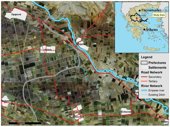
Figure 1.
Study area, Lefki, region of Thessaly (Greece).
3.2. Study Period and Data Collection
The investigation of the paddy field location in the region of Farsala was based primarily on written reports of the agricultural production systems in the official Ottoman archives of the 16th century. Specifically, the censuses of 1506 and 1521 mention the rice-growing zone in the villages of Vrysia (Başhpinar) and Ano Orphana (Çeltküçi Bayezid) and the town of Farsala [62]. In recent years, there has been a surprising increase in the publication of both these archives and various related studies, which, together with descriptions by travellers, contribute to the understanding of land use, production systems and landscapes of the period [63,64]. These sources include information from the agricultural census of 1911 [58], as well as from residents, who confirm the disappearance of the crop in the area. In contrast, a more accurate location for the paddy field is given by the published account of the English traveller William Leake, who explored the area in late 1810, providing information about the anthropogenic and natural environment [65]. He only identified paddy fields in the neighbouring village of Lefki (formerly called Hamedli or Hamekli), which is located 2.5 km south of a paddy field recorded in the 1521 census, i.e., in the village of Çeltküçi Bayezid. This move is presumed to be due to the frequent flooding of the original position.
Additional information on the paddy field location is provided by the aerial photographs from 1945 [66], i.e., before land redistribution, which also confirm the disappearance of rice cultivation in the area. The large number of channels is also noted, but this was reduced by agricultural consolidation after 1970. In addition, topographical and descriptive data were collected, processed and coded in the form of GIS:
- Topographical diagrams with a scale of 1/5000. They show the elevation (contour lines/isohypse at 4 m intervals), toponyms and hydrographic and road networks [66].
- Black-and-white aerial photographs (APs) from 1945 with a scale of 1:4000 and colour APs from 2017 with a scale of 1:5000, with the creation of corresponding orthophoto maps (ordered from the Hellenic Cadastre [66].
- A field study on the communities of the study area and meetings with residents to obtain information on the existence of streams, pre-1970 crops and soil quality through 3D representations.
3.3. Methodology
The methodology for the identification of the paddy field in the study area was aimed to overcome the incompatibility between different sources of information and the subjectivity of narratives by combining three types of information (narratives, other sources, local collective memory) and 3D modelling. The goal was to determine, on the one hand, interactions between the different sources and exchanges between actors based on their recollections, memories and experiences and, on the other hand, the extension in time of their interpretative contribution.
The aim of the first phase of the methodology was the spatialisation of information. In view of the spatial dimension of the elements, it attempted to integrate them as positions, based on a rationale of interdependence, within spatio-functional entities (settlements, irrigation zones, land for food crops, etc.) and systemic relationships (crop rotation). Retrospection was based on information classed in three groups: spatial (position, form, surface area, orientation), functional (organisation of crops, irrigation) and temporal (crop rotation). The second phase involved the creation of a virtual environment with the help and further activation of local collective memory by enabling the active participation of local actors and their collaboration with the researchers.
The two phases are linked through an interactive process that seeks to construct, in terms of integration, the spatial information of the representations and the virtual navigation environment.
The methodology was organised in three interdependent steps:
- Collection and geocoding of historical and contemporary information from bibliographical sources with the use of GIS.
- Use of 3D geovisualisations to obtain information from local actors.
- Application of geoinformatics methods (spatial analysis) to reveal and identify elements.
The following figure illustrates the methodological chain which incorporates the above-mentioned steps (Figure 2).
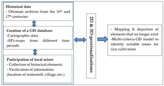
Figure 2.
Flowchart of the proposed methodology.
Each of the three steps is described below.
3.3.1. Collection of Historical and Current Information
Difficulties were encountered in demarcating the paddy field, as (a) according to the agricultural censuses, since the beginning of the 20th century, rice is no longer cultivated and (b) after 1965, land consolidation changed the landscape and the paddy field basin (because the Muslim population of Thessaly, who was the main consumer of rice, left). The first step of the methodology entailed codifying the bibliographic references and focusing on the spatial dimension of the information. The accounts of Leake, the 19th-century traveller, were included in these reports after having first mapped the route he took. At the same time, Ottoman archives were consulted regarding rice cultivation from the 16th to the 19th centuries in the Balkans and in the study area [45,49]. A geodatabase with geographic layers and a high-resolution satellite base map were created in a GIS environment. Next, the historical information was coded and spatially stored in the digital geospatial database. Information on land use/land cover, settlement locations and the road and hydrographic networks was then recorded for the period before land consolidation, i.e., before the 1970s. In addition, a detailed elevation map and a corresponding slope map of the area were created (Figure 3).
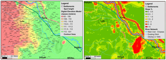
Figure 3.
Mapping of elevation and creation of a slope map.
The cartographic data were enhanced with the results of the processing comparison between the 1945 and 2017 aerial photographs. The main working hypothesis was that the hydrographic network mapped in the 1945 APs remained unchanged from the 16th century to the 1970s [3], when land consolidation brought about significant changes. Information on the old hydrographic network was stored in the digital geospatial database.
The map below shows the channels before land consolidation, the small lake in Xtouri, which was drained and is now cultivated land, and, lastly, the route taken by Leake after the village of Orphana and up to “Xtouri” (Figure 4).
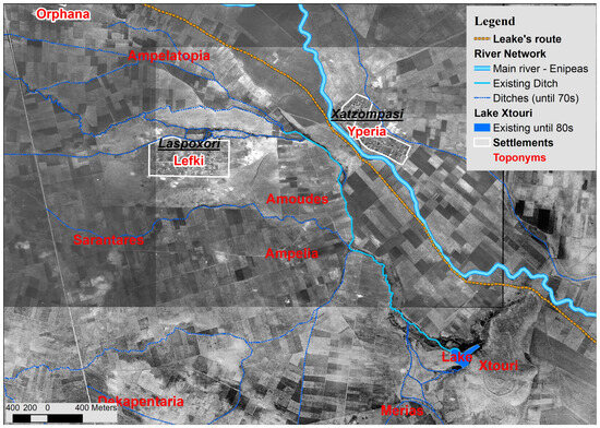
Figure 4.
Mapping of the hydrographic network with the use of aerial photos from 1945.
3.3.2. Participatory Processes Using 3D Geovisualisations
The objective in the second step was to complete the 3D GIS geovisualisations in order to support the participatory process with the residents of the community of Lefki. In this context, 3D GIS interactive cartographic data were first created. The geospatial information coded in the previous step was rendered in a 3D environment (hydrographic and road networks, toponyms, settlement locations, etc.). More specifically, the 3D GIS representations referred to two time periods: (a) the current landscape and spatial structures and (b) the form and surface area of the villages and landscape in 1945. The depiction of the current landscape was used as a bridge in the reconstruction of the old landscape (projection of the above geospatial information), or in other words as a guide in the activation of actors, who are the bearers of local collective memory. The following figure shows snapshots of the two interactive maps (Figure 5). Both the land structures before consolidation, which were characterised by small plots, and the dense hydrographic network, which extended a short distance east and northwest of the settlement of Lefki, are evident in the 1945 landscape.
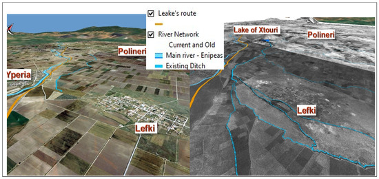
Figure 5.
Three-dimensional GIS visualisations of the contemporary (left image) and past (1945) landscape (right image).
Next, the 3D models (3D geovisualisations) were presented to residents and the diaspora of the community of Lefki in order to collect information with a bottom-up approach. Residents, as carriers of collective local memory, are an important source of knowledge about the landscape, land use, farming systems, water management, etc. in the community of the past. The following criteria were used to select interviewees:
- Willingness to share information.
- Born in the 1950s or earlier.
- Knowledge of the area (farmers by profession) with a good sense of orientation.
The main purpose of the village meetings was to obtain information on the use of channels, flood zones, soil characteristics, agricultural land use and community pasture boundaries before land consolidation occurred (1950s) (Figure 6). The 3D interactive model was used in each meeting as a key tool to depict elements of the space, for visibility and time distance analysis, to help participants quickly and easily identify positions of interest and for the research team to record the information with a spatial reference. The spatial information collected was coded and stored in the geospatial database.
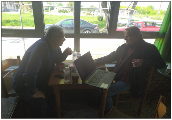
Figure 6.
Meetings with local residents.
With the process above and the participation of residents, the old hydrographic network (from the 15th and 16th centuries) was confirmed, and two flood-prone areas, which are dependent on the frequency and range of the phenomenon, were identified: (a) the most flood-prone zone was located on the eastern boundary of the community next to the path of the river Enipeas, and (b) more minor flooding occurred northeast of the village, where the central ditch branched into smaller ones. In addition, uses were identified that existed until the mid-20th century to the north and northeast of the settlement, as well as food crops to the southeast and the locations of the watermill and of the residence (konak) of the large landowner. Lastly, the residential zone of the village in the 18th century was delimited. All the information was rendered in the 3D-GIS environment after being coded in the geodatabase (Figure 7).
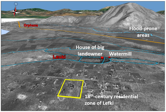
Figure 7.
Collecting information from local residents by applying 3D PGIS to the study area.
3.3.3. Identification Criteria for Suitability Zones
The spatial analysis methodology was applied to identify suitability zones for rice cultivation by combining spatial variables such as (a) soil topographical characteristics; (b) density and structure of the hydrographic network, as mapped using the 1945 APs; (c) distance from the Enipeas River, in order to map the areas vulnerable to flooding; (d) distance from the water source (Xtouri lake) to allow its temperature to rise to levels suitable for rice cultivation.
- ➢
- Soil and Topographical Characteristics
Specific soil characteristics, such as the ones found in the area crossed by the small central stream originating from the adjacent source (Xtouri) and its small branches, are crucial in choosing where to position a paddy field (Figure 4). These areas are characterised by alluvial soils [67], i.e., deposits of clay, sand, gravel and other loose materials produced by flooding, making them appropriate for paddy field cultivation because they contain an abundance of organic matter. The detailed soil characteristics were retrieved from aerial photos from 1945 and verified by residents.
The next element entailed identifying the flattest surfaces based on slopes and elevation differences in the wider area of the settlement of Lefki (Figure 3). The topographical analysis revealed that, in the areas with the densest hydrographic network, i.e., north–northeast of the settlement, and for a distance of about 1.5 km (total area of 200 ha), the differences in elevation do not exceed 2 m (111–109 m). The small elevation difference in this almost flat zone to the northeast of the village allows water to be channelled downstream and partly upstream.
Lastly, swamps in the area northwest of the village of Lefki were identified and delimited. These swamps existed until the mid-20th century, as verified by the residents during the participatory processes.
- ➢
- Irrigation Infrastructure
Continuous irrigation of the paddy field was achieved through small channels connected to a central ditch, which was fed by the adjacent spring-lake of Xtouri (3.5 km from the village of Lefki) (Figure 4). The supply from the spring was continuous and significant until 1960, with fluctuations between the winter and summer seasons. The central ditch followed a path of about 2 km from its source to the north before taking a northwestern direction, passing the village after about 1.5 km. There was a first fork in the ditch at the height of the village of Lefki and a distance of 700 m, followed by a second fork 500 m to the west. In this zone, which extends north and northeast of the settlement, there was a dense branching of natural and artificial channels which enabled water to be channelled through small dams when necessary. This dense network of channels enabled and supported the organisation of rice cultivation and the necessary plot rotation.
- ➢
- Multi-criteria model
The combination of soil characteristics and use (e.g., legume zone), the gentle slopes and the direction of the channels and of the prevailing winds (west-southwesterly and northeasterly winds), provided an initial impression of the possible siting zones as well as the layout of the paddy basin and the bunds. The GIS multi-criteria model that was developed was based on the analytical hierarchy process, as proposed by Saaty [68]. In order to construct the pairwise matrix, the weights of the parameters were retrieved based on the literature [69,70] and discussions with local experts in the agricultural domain. The final pairwise comparison matrix and the weights of each parameter are presented in the table below (Table 1).

Table 1.
Pairwise comparison matrix and the weights of parameters.
Each criterion was classified and standardised into 5 suitability categories: high suitability, moderate suitability, marginal suitability, current unsuitability and permanent unsuitability [71]. This classification was based on the literature regarding the necessity of water and takes into account the lack of mechanical means for cultivation. The four main criteria, with their respective categorisations, are presented in the table below (Table 2).
Table 2.
Standardisation of criteria regarding the suitability of paddy fields (distance in metres).
Next, to more precisely identify the paddy field location, information provided by travellers and the local community was used. In particular, Leake reported that the village of Lefki was located at a distance of 1 mile (1.6 km) to the east of the village of Hadziombasi, surrounded by paddy fields. Therefore, the paddy field visibility criterion (<1.6 km) from the position of the traveller was added to the multi-criteria model.
The final step in the methodology involved analysing the candidate suitability zones at the level of the rice paddy basin. Techniques and practices related to the organisation of rice cultivation in the space (basin orientation) and on plots (constructing bunds, etc.) within the space were examined. The analysis of wind direction in relation to the possible location and layout of the paddy field was also an important element.
4. Results
4.1. Suitability Map
The map resulting from the multi-criteria model identifies the zones of high suitability for rice cultivation in the north-northeastern part of the village and the boundaries of the community of Lefki (Figure 8). The analysis focuses on the first two suitability categories: (a) the high-suitability zone found to the north of the village and (b) the moderate-suitability zone, which is adjacent to the former and surrounds the village.
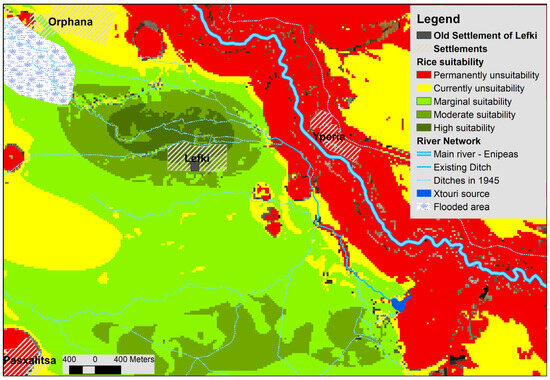
Figure 8.
Variations in land suitability classes for rice cultivation from the 15th to the 18th century.
The following is an analysis of the interior of these zones (especially around the village of Lefki) using additional siting criteria for the 15th-century rice paddies. One of the main criteria is the surface area required for rice cultivation. The Ottoman registers of 1454 state that rice cultivation in this community occupied an area of approximately 3.5 hectares, for which, however, a total of 7 hectares was reserved, if the additional area necessary for crop rotation is considered. At the same time, additional siting criteria have been used, as noted below.
4.2. Identifying the Location of the Paddy Field
To identify the most accurate siting and layout of the paddy field, a second set of determining factors was taken into account:
- Zone dedicated to crops for own personal consumption (legumes, etc.) due to specific soil characteristics (deposits of clay, sand, gravel). It is located at a distance of 600 m, east-southeast of the village of Lefki, in a zone of sandy soils, fragmented into small parcels of 0.5–1 ha. This zone lies outside the flood zone upstream of the channel branches and therefore could not be used for rice cultivation.
- Information from residents that the toponym “rice” (Ryzia) extended northeast of the village of Lefki above the road connecting the villages of Hyperia-Lefki.
- The zone crossed by the first and second forks in the channels from the central ditch. The choice of channels enabled better water management and uninterrupted flow for the neighbouring communities, as required by the regulation.
- Adequate distance from the large landowner’s residence (konak) (to avoid humidity and mosquitoes). For this purpose, a 200 m exclusion zone was created.
- Leake’s report that rice paddies surrounded the village for a mile (1.6 km) [65]. It is argued that Leake’s ability to identify rice paddies from a distance of approximately 1600 m in December, i.e., when the rice harvest and water draining had already been completed, was based on the existence of bunds and special constructions, known as “tigania” [65].
- The directions of the strongest winds in the area in relation to the position and layout of the paddy field. The west and northwest layout of the artificial channels north of the village, combined with the strong local westerly and northeasterly winds (which blow especially in spring), indicate the existence of two potential adjacent locations for a rice paddy (A and B), as shown in the following figure (Figure 9). At these locations, the layout of the paddy basin was determined based on the layout of the channels.
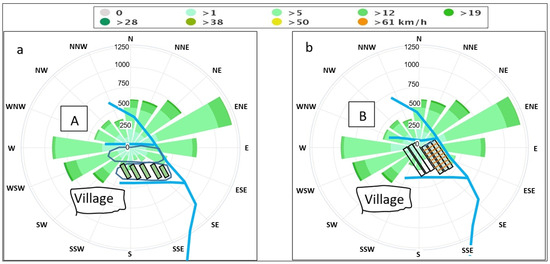 Figure 9. Position and layout of the paddy field in relation to wind directions (a,b).
In view of the above criteria and the necessary conditions for rice cultivation, two candidate areas (within the initial suitability zones) which do not exceed 11.5 ha were identified (Figure 10). In these areas, land levelling, the most important task for paddy fields, is easy, since along the approximately 800 m separating the eastern and western edges, the difference in elevation does not exceed 1 m. This means that a difference between the highest and lowest point of the paddy basin of between 2 and 5 cm/100 m is easily achievable.
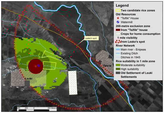
Figure 10.
Two candidate zones for rice cultivation.
There are two possibilities for the location and layout of the rice paddies based on (a) the crop’s agronomic requirements (rotation of plots, soil characteristics), (b) the topography and the network of channels (slope, river flow) combined with the wind directions and (c) the estimate that the total area dedicated to rice cultivation (cultivation and crop rotation) did not exceed 7 ha. As the study shows, these two possible rice paddy locations are almost adjacent and have the same characteristics that are required for the effective operation and yield of a rice paddy. In both cases, the results highlight the optimal factors, as follows:
- Siting of the paddy fields chosen in order to combine (i) soil characteristics (deposits of clay, sand, gravel), (ii) the use of the local hydrographic network (other crops) sharing water with downstream communities through which the ditch passes and (iii) the appropriate location and layout of the paddy field to prevent impacts on health (malaria) and the crop due to winds.
- Integration of the paddy field into the mixed production system and the local agro-ecological system (biodiversity, ecological water, etc.) without impacting them. Although the spatial-agronomic criteria would support the expansion of the paddy field, its surface area seems to also be determined by the obligation of the community of Lefki to supply the other communities with part of the water from the ditch.
5. Discussion
Historical retrospection (to at least 400 years ago) to reconstruct the paddy field in the community of Lefki faced two challenges. First is the lack of experience of the local community due to the abandonment of rice cultivation prior to 1880 and the degradation of the local ecosystem resulting from the implementation of an intensive agricultural model since 1960. In essence, none of the interlocutors (or the previous two generations) had direct knowledge of the organisation of rice cultivation, while the implementation of land consolidation after 1960 erased any traces of its cultivation [72]. Second was addressing rice cultivation as inherited knowledge through the current needs of territorial dynamics and agro-ecological transition. The applied participatory interactive methodology functioned as a process that safeguards past knowledge and practices regarding spatial organisation and the sustainable management of resources from oblivion. In view of these challenges, the research results are viewed from two perspectives.
The first concerns the participatory, interactive methodology itself. This combines (a) the direct insight provided by the 3D geovisualisation of the data from the description (in situ), (b) switching between visualisations that use geospatial information (aerial photographs, satellite images, etc.) with different spatial and temporal resolutions (in visu) and (c) the collective memory of local actors surrounding the history of places [73]. The methodology is organised through a process of successive phases identifying the early 19th-century space using a combination of sources, methods and representations. Technically, the creation of 3D-GIS interactive representations combined low-resolution black-and-white aerial photographs from 1945 with higher-resolution colour photographs from 2017. By focusing on the coordination of available sources, this combination utilises the spatial dimension of information as an element of spatial subsystems. This process is supported by the 3D-GIS interactive model, contributing to the gradual spatial interpretation and integration of heterogeneous information and local collective memory as a source of information. This environment was enhanced with additional information such as toponyms, settlement locations, road and hydrographic networks, etc. The ability to depict these elements enables the gradual development of this virtual space on the basis of a two-way contribution: the more local actors gradually identify this space, the more it is enriched with additional information.
This methodological process addresses the gap in the literature regarding applications that mainly involve intangible heritage (during the Ottoman period, 15th–18th century) elements in rural areas. Indeed, most applications focus on urban spaces using 3D representations and are limited to the present and issues relating to participatory planning and decision making [74,75,76,77,78]. The methodology addresses this gap by aggregating resources and creating information nodes with potential interconnections. Through navigation in a virtual environment, it integrates and organises this information based on its reference to the position and function of elements of the spatial system (land use and appropriation, networks, etc.). Links, interdependencies and connections between these elements within the spatial systems emerge. Combining these systemic interdependencies with the information available reduces incompatibilities and also creates synergies between information sources. By helping to “awaken” and activate local collective memory, this reconstructed depiction led to a continuous improvement in the representativeness of the space and its systems. At the same time, it facilitated the transition of actors and information from past to present and from virtual to real space.
The second perspective concerns identifying paddy-related elements that allowed for the reconstruction and understanding of the farming system organisation within spatio-temporal planning. It is noted that identifying the paddy field location in the community space was enabled by combining, (a) on the one hand, the reconstruction of the landscape, which acted as a spatial foundation for the identification of land cover and use and the position and function of elements of the spatial system in the area but also as a reference space for local collective memory, and, (b) on the other hand, the strong interdependence between the rice cultivation system, the physiography and geomorphology of the area and the various technical and topographical combinations (distance from the source, slopes, water flow/flow control, wind direction, etc.). Visualising these combinations through mapping helped, on the one hand, to highlight the location and function of these elements within the spatio-temporal organisation of the rice paddy and, on the other hand, to identify the close relationship between rice cultivation and natural resources, uncovering relevant knowledge. It therefore makes clear the organisation, in the specific space, of the overall scheduling which regulated, combined and coordinated the farming needs of rice in relation to the physiography. This reconstitution of the horizontal organisation of rice cultivation elucidates its functioning within a coherent vertical organisation that is regulated by very precise rules, coordinated by the central administration with an interesting tiered administration. Within the community, the multidimensional knowledge of the community of the past is highlighted in terms of establishing the optimal relationship between the siting and organisation of the rice paddies. The methodology succeeds in identifying and projecting in space the locations of the elements and the functioning of the systems (cultivation system, irrigation, etc.), contributing to the understanding of the integration of the paddy field as a subsystem in the wider production and agro-ecological (biodiversity, ecology, water, etc.) system. The detail in organising this integration enables values and principles to emerge, such as the protection of health, respect for the equitable distribution of water to the other communities as a public good and agro-ecological harmony with the conscious preservation of flora and fauna as elements for the continuation of life [79]. The technical insight of more specialised researchers can enhance this knowledge and further investigate the extent to which they can support the agro-ecological transition process for areas such as the community of Lefki.
5.1. Role of the Represented Space
It was found that the virtual reconstruction of a paddy field that no longer exists, by navigating a not-so-recent past, is based, in practice, on the interoperability of an informational, communicative and even anthropological process enabled by the methodology applied. This interoperability is defined as the possibility of interaction between information and communication during a bidirectional journey in space and time during the process of 3D geovisualisation using appropriate techniques and methods [3,80]. The methodological process guides the interaction between information and communication, facilitating the active participation of the community in this retrospection. In this 3D interactive environment, the combination of sources and collective memory produces and corrects information. In other words, a two-way relationship between information and communication is created, driven by collective memory. This relationship is activated by participatory processes which are enhanced with new forms of mapping incorporated in the methodological chain, such as 3D interactive visualisations. The resulting interactivity also fosters a two-way contribution to further improve the representability of the landscape. This virtual environment forms a hybrid space based on the real (that which has been preserved) and the virtual (that which can be represented) space. This space becomes functional through the activation of 3D interactive visualisation models, allowing different time periods to be connected (transition from the pre- to the post-land consolidation period, drainage of the neighbouring lake). In essence, collective memory refers to a historical space which is provided to the collective memory as a source of the historical information that the memory itself carries. Incorporating new technologies into the methodology ultimately boosts community memory, as it can record both the formal and the more difficult-to-identify informal knowledge and project it through 3D interactive representations [81].
5.2. Contribution of Past Knowledge to Planning the Future
By fostering interaction between information from different sources, with the space as a common reference, this interactive methodology extends beyond the simple transfer of information, creating conditions for communication and enabling a joint approach (GIS spatial analysis–3D visualisation (current–past): the contribution of 3D in information extraction) [19,20,21,24] to knowledge. By moving between information, space and the system, actors identify and register abstract elements of cognitive heritage related to natural resource management as an element of community intelligence. Common inherited knowledge on the sustainable management of the relationship between people, animals and natural resources is now transformed into knowledge of territorial local intelligence. For instance, knowledge about the functioning of a complex farming system such as paddy fields regains its role in the current management needs of public goods (water, pasture, etc.), contributing to the creation of a Commons institution [82]. By intervening in the creation and/or management of common goods, the community can draw on collective knowledge, values, etc., from the past which contribute to the organisation of sustainable, spatially anchored agro-ecosystems. This contribution is important for rural communities that are being rebuilt and are undergoing socio-economic and agro-ecological transitions [83]. The methodological process enriches spatial thinking by facilitating immersion in the past, thus contributing to the “production adjustment” effort of territorial areas and mediating with the outside world [10,84] in terms of their distinctiveness. This readjustment is based on the combination of heterogeneous knowledge and knowledge which creates new knowledge. This knowledge can, in turn, participate in new configurations [85] such as the harmonisation of environmental management and the socio-economic adjustments of the territorial and production space. The methodological process involved in organising this knowledge cognitively enriches these configurations with the participation of local actors [86].
More specifically, it seems that the present methodological process of activating a network of sources with a significant flow of information and knowledge could also contribute to the planning of small-scale territorial development. Although this network is temporary (for the duration of the research), it constitutes a reliable source of inherited knowledge. However, any community seeking to incorporate this inherited knowledge into planning, e.g., for agro-ecological transition, needs to integrate it into a learning process due to its tacit nature. This process will allow inherited knowledge to be connected to new knowledge produced by scientific research [87,88]. The combined methodology can, as an informational and interactive system, support such a process. Despite their technocratic nature, when digital tools are combined with the participation of local actors, they offer new possibilities for approaching knowledge and space as a social creation. They facilitate the functioning of local democracy by supporting consultation and decision making but also cooperation and coordination, ensuring transparency and trust between actors [73]. They can also help, on the one hand, to strengthen learning capacity and knowledge management at the community level, as a component of the development of a territorial area [89], and, on the other hand, to educate the new generation of citizens who envisage the sustainable development and resilience of the place by drawing on knowledge from the past. Lastly, it seems that the technical capacities of the methodology, combined with the qualitative methods of social research, also facilitate the use of this knowledge in territorial engineering [83].
The combined methodology helps this knowledge participate in the co-construction of territorial knowledge as well as in the processes of territorialisation and sustainable development. Since this knowledge provides elements of specificity and helps harmonise the human–nature relationship, the community would benefit from integrating it into its territorial planning. The resulting knowledge adds another string to the bow of a territorial area that attempts to valorise resources constructed endogenously, contributes to distinctiveness and the agro-ecological transition and offers values that are compatible with the objectives of sustainable territorial development [90]. Finally, knowledge from the past and the methodology itself support the integration of agro-ecological and socio-economic adjustments at the level of the territorial area.
6. Conclusions
The global transition towards ecology [91], by complementing the concept of “local”, emphasises the need to re-observe the relationship between natural resources and anthropogenic activities and thus revalorise past knowledge [92]. The interest in reconstructing a highly spatially anchored rice cultivation system organised five centuries ago is limited neither to a given historical moment nor to the search for an interpretation of the present in that moment [93]. Its value stems from two findings: (a) it carries experience and timeless values from the past that result from the successful regulation by a centralised administration, such as the Ottoman administration, with the community, of the complex relationship between the crop, natural resources and the market, thus preserving the place of rice, a product which is nutritious and was culturally valuable to the nutritional needs of the time, and (b) it illuminates the road to agro-ecological transition and can contribute to new future uses determined by current local (resource specificity) and global challenges such as sustainable development and climate change. Faced with these stakes, local communities are realising that modernisation alone is not a solution and that heritage is relevant. They also realise that this knowledge can contribute to the resilience of local communities in the form of knowledge capital integrated with territorial intelligence. If the concept of territorial intelligence is therefore linked to the capacity of local actors to collectively acquire knowledge capital, then an interactive methodology can contribute to this integration [94,95]. In this case, past knowledge, with its goal of territorial development, and the territorial community as its object [96], acquires a new social utility.
Indeed, the value of this knowledge stems from the fact that it refers to “nature’s rationale” and helps understand its components before the impact from the adoption of an intensive agricultural model which started in the middle of the 20th century and intensified after 1970 with the modernisation, mechanisation and reclamation of the plains of Greece. Projected onto space, knowledge from the past helps us to see again, albeit virtually, natural features in geographical space and to approach harmony between the countryside and the environment through the human–nature interaction. Finally, it allows us to understand the contrast between the self-regulation of ecosystems and anthropogenic actions. Following the evolution of the interaction between naturality and spatiality and as a result of both spatial and ecological analysis, this knowledge helps reposition interdisciplinary approaches in order to prevent them from being limited to ecology or overlooking the environment or structures or even disregarding the laws of spatial organisation [47].
Author Contributions
D.G. and I.F. conceptualised the research, performed the validation, and wrote the manuscript. All authors have read and agreed to the published version of the manuscript.
Funding
This research received no external funding.
Data Availability Statement
The original contributions presented in the study are included in the article, further inquiries can be directed to the corresponding author.
Conflicts of Interest
The authors declare no conflicts of interest.
References
- Campagne, P.; Pecqueur, B. Le Développement Territorial. Une Réponse Émergente à la Mondialisation; Éditions Charles Léopold Mayer (ECLM): Paris, France, 2014; p. 268. ISBN 978-2-84377-184-2. [Google Scholar]
- Goussios, D.; Faraslis, I. Integrated Remote Sensing and 3D GIS Methodology to Strengthen Public Participation and Identify Cultural Resources. Land 2022, 11, 1657. [Google Scholar] [CrossRef]
- Goussios, D.; Faraslis, I. The Driving Role of 3D Geovisualization in the Reanimation of Local Collective Memory and Historical Sources for the Reconstitution of Rural Landscapes. Land 2023, 12, 364. [Google Scholar] [CrossRef]
- Di Méo, G. Le patrimoine, un besoin social contemporain. In Proceedings of the Patrimoine et Estuaires, Actes du Colloque International de Blaye, Blaye, France, 5–7 October 2005; Available online: https://shs.hal.science/halshs-00281467 (accessed on 2 May 2024).
- Talandier, M.; Navarre, F.; Cormier, L.; Landel, P.A.; Ruault, J.F.; Senil, N. Les Sites Patrimoniaux Exceptionnels: Une Ressource Pour les Territoires; Editions du PUCA: Lyon, France, 2019; p. 319.
- Senil, N.; Landel, P.A. De la ressource territoriale à la ressource patrimoniale. In Au Cœur des Territoires Créatifs. Proximités et Ressources Territoriales; Glon, E., Pecqueur, B., Eds.; Presses Universitaires de Rennes: Rennes, France, 2016; ISBN 978-2-7535-4951-7. [Google Scholar]
- Le Coz, J. Espaces méditerranéens et dynamiques agraires: État territorial et communautés rurales. In Espaces Méditerranéens et Dynamiques Agraires: État Territorial et Communautés Rurales; Le Coz, J., Ed.; CIHEAM: Montpellier, France, 1990; pp. 1–393. [Google Scholar]
- Guy, B. Troubles with Remembering; or, the Seven Sins of Memory Studies; Dublin Review of Books: Dublin, Ireland, 2017; p. 218. [Google Scholar] [CrossRef]
- Gouriveau, F.; Beaufoy, G.; Moran, J.M.; Poux, X.; Herzon, I.; Ferraz de Oliveira, M.I.; Gaki, D.; Gaspart, M.; Genevet, E.; Goussios, D.; et al. What EU Policy Framework Do We Need to Sustain High Nature Value (HNV) Farming and Biodiversity? 2019. Available online: https://hal.science/hal-02568129 (accessed on 2 May 2024).
- Bernard, C.; Poux, X.; Herzon, I.; Moran, J.; Pinto-Correia, T.; Dumitras, D.E.; Ferraz-de-Oliveira, M.I.; Gouriveau, F.; Goussios, D.; Jitea, M.I.; et al. Innovation brokers in High Nature Value farming areas: A strategic approach to engage effective socioeconomic and agroecological dynamics. Ecol. Soc. 2023, 28, 20. [Google Scholar] [CrossRef]
- UN. Transforming Our World: The 2030 Agenda for Sustainable Development. Resolution Adopted by the General Assembly on 25 September 2015, 42809, 1–13. Available online: https://www.scirp.org/reference/referencespapers?referenceid=2223553 (accessed on 2 May 2024).
- Landel, P.A. Invention de Patrimoines et Construction des Territoires. La Ressour. Territ 2007, 157–176. Available online: https://shs.hal.science/halshs-00320442 (accessed on 2 May 2024).
- Janin, C.; Landel, P.A.; Bergeret, A.; Buclet, N.; Girard, S. Intelligence Collective: Penser, Décider, Agir Ensemble sur les Territoires; Chronique Sociale: Lyon, France, 2021; p. 203. [Google Scholar]
- Scazzosi, L. Rural Landscape as Heritage: Reasons for and Implications of Principles Concerning Rural Landscapes as Heritage ICOMOS-IFLA 2017. Built Herit. 2018, 2, 39–52. [Google Scholar] [CrossRef]
- Prus, B.; Dudzińska, M.; Bacior, S. Determining and quantifying the historical traces of spatial land arrangements in rural landscapes of Central and Eastern Europe. Sci. Rep. 2021, 11, 23421. [Google Scholar] [CrossRef] [PubMed]
- Groupe de Bruges. Agriculture: Un Tournant Necessaire, 2nd ed.; La Tour d’Aigues: l’Aube, France, 2002; p. 89. ISBN 978-2-87678-708-7. [Google Scholar]
- Hargreaves, A. Four Ages of Professionalism and Professional Learning. Teach. Teach. Theory Pract. 2000, 6, 151–182. [Google Scholar] [CrossRef]
- Sofos, A. Pedagogical and Instructional Competence in Teacher Education: A Review of Practices and Recommendations. In Pedagogical Departments and Their Future; Sofos, A., Darra, M., Tsibidaki, A., Kladaki, M., Kostas, A., Eds.; Grigoris: Athens, Greece, 2019; pp. 81–108. (In Greek) [Google Scholar]
- Nora, P. Between Memory and History: Les Lieux de Mémoire. Representations 1989, 26, 7–24. [Google Scholar] [CrossRef]
- Piveteau, J.L. L’épaisseur Temporelle de L’organisation de L’espace: «Palimpseste» et «Coupe Transversale». Géopoint 90 Hist. Temps Espace 1990, 211–220. Available online: https://pandor.u-bourgogne.fr/archives-en-ligne/ead.html?id=FRMSH021_00052&c=FRMSH021_00052_GEOP_1990&qid= (accessed on 10 March 2024).
- Piveteau, J.L. Le territoire est-il un lieu de mémoire? Espace Géogr. 1995, 24–2, 113–123. [Google Scholar] [CrossRef]
- Fominykh, M.; Prasolova-Førland, E.; Hokstad, L.; Morozov, M. Repositories of Community Memory as Visualized Activities in 3D Virtual Worlds. In Proceedings of the 47th Hawaii International Conference on System Sciences (HICSS), Waikoloa, HI, USA, 6 January 2014. [Google Scholar] [CrossRef]
- Lokka, I.; Çöltekin, A. Simulating Navigation with Virtual 3d Geovisualizations—A Focus On Memory Related Factors. Int. Arch. Photogramm. Remote Sens. Spatial Inf. Sci. 2016, XLI-B2, 671–673. [Google Scholar] [CrossRef]
- Sorre, M. Connaissance du paysage humain. Bull. De La Société De Géographie De Lille 1958, 1, 5–14. [Google Scholar]
- Pinchemel, P.G. La Face de la Terre; Armand Colin: Paris, France, 1988; p. 519. [Google Scholar]
- Arrighi, C.; Francesco, B.; Tommaso, S. A GIS-based flood damage index for cultural heritage. Int. J. Disaster Risk Reduc. 2023, 90, 103654. [Google Scholar] [CrossRef]
- Ciski, M.; Krzysztof, R.; Marek, O. Use of GIS Tools in Sustainable Heritage Management—The Importance of Data Generalization in Spatial Modeling. Sustainability 2019, 11, 5616. [Google Scholar] [CrossRef]
- Biscione, M.; Danese, M.; Masini, N. A framework for cultural heritage management and research: The Cancellara case study. J. Maps 2018, 14, 576–582. [Google Scholar] [CrossRef]
- Elfadaly, A.; Shams Eldein, A.; Lasaponara, R. Cultural Heritage Management Using Remote Sensing Data and GIS Techniques around the Archaeological Area of Ancient Jeddah in Jeddah City, Saudi Arabia. Sustainability 2020, 12, 240. [Google Scholar] [CrossRef]
- Huang, S.; Hu, Q.; Wang, S.; Li, H. Ecological Risk Assessment of World Heritage Sites Using RS and GIS: A Case Study of Huangshan Mountain. Chin. Geogr. Sci. 2022, 32, 808–823. [Google Scholar] [CrossRef]
- Liang, J.; Chen, J.; Tong, D.; Li, X. Planning control over rural land transformation in Hong Kong: A remote sensing analysis of spatio-temporal land use change patterns. Land Use Policy 2022, 119, 106159. [Google Scholar] [CrossRef]
- La Frenierre, J. Mapping heritage: A participatory technique for identifying tangible and intangible cultural heritage. Int. J. Incl. Mus. 2008, 1, 97–104. [Google Scholar] [CrossRef]
- Santos, B.; Gonçalves, J.; Almeida, P.G.; Martins-Nepomuceno, M.T.A. GIS-based inventory for safeguarding and promoting Portuguese glazed tiles cultural heritage. Herit. Sci. 2023, 11, 133. [Google Scholar] [CrossRef]
- Armin, G. SMART Cities: The need for spatial intelligence. Geo-Spat. Inf. Sci. 2013, 16, 3–6. [Google Scholar] [CrossRef]
- Papachristophorou, M. Narrative Maps, Collective Memory, and Identities: Through an Ethnographic Example from the Southeast Aegean. Narrat. Cult. 2016, 3, 4. [Google Scholar] [CrossRef]
- McCormick, B.H.; DeFanti, T.A.; Brown, M.D. Visualization in Scientific Computing. Comput. Graph. 1987, 21. Available online: https://www.evl.uic.edu/pubs/1501 (accessed on 30 April 2024). [CrossRef]
- Punia, M.; KUNDU, A. Three dimensional modelling and rural landscape geo-visualization using geo-spatial science and technology. Neo Geogr. 2014, 3, 1–19. [Google Scholar]
- Yu, L.; Zhang, X.; He, F.; Wang, X. Participatory Historical Village Landscape Analysis Using a Virtual Globe-Based 3D PGIS: Guizhou, China. Sustainability 2022, 14, 14022. [Google Scholar] [CrossRef]
- Sandham, L.A.; Chabalala, J.J.; Spaling, H.H. Participatory Rural Appraisal Approaches for Public Participation in EIA: Lessons from South Africa. Land 2019, 8, 150. [Google Scholar] [CrossRef]
- Mazagol, P.O.; Niogret, P.; Riquier, J.; Depeyre, M.; Ratajczak, R.; Crispim-Junior, C.F.; Tougne, L. Tools Against Oblivion: 3D Visualization of Sunken Landscapes and Cultural Heritages Applied to a Dam Reservoir in the Gorges de la Loire (France). J. Geovisualization Spat. Ana. 2021, 5, 2. [Google Scholar] [CrossRef]
- Campanaro, M.D.; Landeschi, G.; Dell’Unto, N.; Leander Touati, A.M. 3D GIS for cultural heritage restoration: A ‘white box’ workflow. J. Cult. Herit. 2016, 18, 321–332. [Google Scholar] [CrossRef]
- Dhonju, H.K.; Xiao, W.; Mills, J.P.; Sarhosis, V. Share Our Cultural Heritage (SOCH): Worldwide 3D Heritage Reconstruction and Visualization via Web and Mobile GIS. ISPRS Int. J. Geo-Inf. 2018, 7, 360. [Google Scholar] [CrossRef]
- Colucci, E.; Matrone, F.; Noardo, F.; Assumma, V.; Datola, G.; Appiotti, F.; Bottero, M.; Chiabrando, F.; Lombardi, P.; Migliorini, M.; et al. Documenting cultural heritage in an INSPIRE-based 3D GIS for risk and vulnerability analysis. J. Cult. Herit. Manag. Sustain. Dev. 2024, 14, 205–234. [Google Scholar] [CrossRef]
- Larrain, A.A.; McCall, Κ.M. Participatory Mapping and Participatory GIS for Historical and Archaeological Landscape Studies: A Critical Review. J. Archaeol. Method Theory 2019, 26, 643–678. [Google Scholar] [CrossRef]
- İnalcik, H. Rice cultivation and the çeltukci-re’aya system in the Ottoman empire. Turc. Rev. D’etudes Turques 1982, 14, 69–141. [Google Scholar]
- Infelise, L. Territoire Anticipateur: Un «être Vivant» en Apprentissage. Pour 2006, 192, 180–185. Available online: https://www.artes-research.com/wp-content/uploads/2016/02/POUR-Infelise-Territoire-Anticipateur.pdf (accessed on 5 March 2024).
- Baudelle, G.P.; Pinchemel, G. La Face de la Terre. Hommes Et Terres Du Nord. 1989, 1–2, 118. Available online: https://www.persee.fr/doc/htn_0018-439x_1989_num_1_1_2212_t1_0118_0000_1 (accessed on 30 April 2024).
- Birnbaum, D.M. The Fuggers, Hans Dernschwam, and the Ottoman Empire. Southeast Res. 2021, 1, 119–144. Available online: http://bsb0sit-zepweb01.bsb.lrz.de/portal/index.php/sof/article/view/8187 (accessed on 10 April 2024).
- Karagöz, M. 1193/1779 senesi Rüsum Defteri’ne Göre Bazarcık-Tatarpazarı’nda Pirinç Üretimi. Fırat Üniversitesi Sos. Bilim. Derg. 2004, 14, 275–299. Available online: http://hdl.handle.net/11616/42633 (accessed on 2 May 2024).
- Emecen, F.; Çeltik, D.İ.A. TDV (Türkiye Diyanet Vakfı) İslam Ansiklopedisi. Istanbul 1993, 8, 265–266. [Google Scholar]
- Nesbitt, M.; Simpson, S.J.; Svanberg, I. History of rice in Western and Central Asia. In Rice: Origin, Antiquity and History; Sharma, S.D., Ed.; Science Publishers: Enfield, NH, USA, 2010; pp. 308–340. [Google Scholar]
- Sarıkaya, H.T.T. 0008 Numaralı Tapu Tahrir Defteri’nin Transkripsiyonu ve Tahlili. Adnan Menderes Üniversitesi, Sosyal Bilimler Enstitüsü, 1/1/2014. Available online: http://194.27.38.21/web/catalog/info.php?idx=52641099&idt=1 (accessed on 10 April 2024).
- Sert, Ö. Environmental History of Rice Plantations in the Early Modern Ottoman Empire Between the 15th And 19th Centuries and Its Potential for Climate Research. J. Environ. Geogr. 2021, 14, 1–14. [Google Scholar] [CrossRef]
- Hütteroth, W.-D. Ecology of the Ottoman lands. In The Cambridge History of Turkey; Faroqhi, S.N., Ed.; Cambridge University Press: Cambridge, UK, 2006; Volume 3, pp. 18–43. [Google Scholar] [CrossRef]
- Beldiceanu, N. L’organisation de l’Empire ottoman (XIVe-XVe siècles). In Histoire de l’Empire Ottoman; Mantran, R., Ed.; Fayard: Paris, France, 1989; p. 129. [Google Scholar]
- Delibasi, M.; Arikan, M. Hicrî 859 Tarihli Sûret-i Defter-i Sancak-i Tirhala; Türk Tarih Kurumu: Ankara, Turkey, 2001; p. 407.
- TAŞ, K.Z. Osmanli Çeltik Üretim Sahasi Olarak Konrapa Ya Da “Osmanli Sarayinin Nadidesi Konuralp Pirinci”. Balıkesir Üniversitesi Sos. Bilim. Enstitüsü Derg. 2020, 23, 1253–1268. [Google Scholar] [CrossRef]
- Hellenic Statistical Authority. Agricultural Census of 1911 (Thessaly and Arta); Ministry of National Economy: Athens, Greece, 1914; p. 71.
- Ministry of Finance. Study on Agricultural Land Production in Thessaly; Ministry of Finance: Athens, Greece, 1896.
- Kairis, O.; Karamanos, A.; Voloudakis, D.; Kapsomenakis, J.; Aratzioglou, C.; Zerefos, C.; Kosmas, C. Identifying Degraded and Sensitive to Desertification Agricultural Soils in Thessaly, Greece, under Simulated Future Climate Scenarios. Land 2022, 11, 395. [Google Scholar] [CrossRef]
- ELSTAT (Hellenic Statistical Authority). National Statistical Service of Greece (NSSG). Available online: https://www.statistics.gr/en/home/ (accessed on 7 July 2024).
- Ozkilinc, A.; Coskun, A.; Sivridag, A.; Yuzbasioglu, M. 367 Numarali Muhasebe-i Vilayet-i Rumili Defteri ile 114, 390 ve 101 Numarali Icmal Defterleri (920-937/1514-1530), t.I-II, Tirhala Livalari: Tıpkıbasım; T.C. Başbakanlık Devlet Arşivleri Genel Müdürlüğü Osmanlı Arşivi Daire Başkanlığı: Ankara, Turkey, 2007.
- Shariat-Panahi, S.M.T. Corinthia in the Ottoman Period; University of Thessaly Press: Volos, Greece, 2015. [Google Scholar]
- Shariat-Panahi, S.M.T. Vasilika and its region in the Ottoman period. In Sikyon I: The Urban Survey; Lolos, I.A., Ed.; Institute of Historical Research: Athens, Greece, 2021; pp. 642–681. [Google Scholar]
- Leake Martin William. Travels in Northern Greece; Rodwell: London, UK, 1835; Volume 4. [Google Scholar]
- Hellenic Cadastre (Land Registry). Athens, Greece. Available online: https://data.ktimatologio.gr/opendata (accessed on 20 February 2024).
- Caputo, R.; Helly, B.; Rapti, D.; Valkaniotis, S. Late Quaternary hydrographic evolution in Thessaly (Central Greece): The crucial role of the Piniada Valley. Quat. Int. 2022, 635, 3–19. [Google Scholar] [CrossRef]
- Saaty, T.L. The Analytic Hierarchy Process: Planning, Priority Setting, Resource Allocation; McGraw Hill: New York, NY, USA, 1980. [Google Scholar]
- Ezra, A.; Adebayo, A.; Sa, U. Application of Analytical Hierarchical Process (AHP) in Development of Suitability Model for Rice Production in Taraba State. Int. J. Sustain. Agric. Res. 2020, 7, 118–133. [Google Scholar] [CrossRef]
- Robertson, N.; Oinam, B. Rice suitability mapping using the analytic hierarchy process approach in a river catchment. Glob. J. Environ. Sci. Manag. 2023, 9, 141–156. [Google Scholar] [CrossRef]
- FAO. A Framework for Land Evaluation. Food and Agriculture Organization of the United Nations. Soils Bull. 1976, 32, 72. Available online: https://www.scribd.com/document/174698346/A-Framework-for-Land-Evaluation-FAO-Soil-Bulletin-32-1976 (accessed on 25 February 2024).
- Sivignon, M. La Thessalie, Analyse Geographiqued’une Province Grecque; I.E.R.: Lyon, France, 1975; p. 572. [Google Scholar]
- Senecah, L.S. The Trinity of Voice: A framework to improve trust and ground decision making in participatory processes. J. Environ. Plan. Manag. 2024, 67, 2091–2115. [Google Scholar] [CrossRef]
- Onitsuka, K.; Ninomiya, K.; Hoshino, S. Potential of 3D Visualization for Collaborative Rural Landscape Planning with Remote Participants. Sustainability 2018, 10, 3059. [Google Scholar] [CrossRef]
- Yu, L.; Zhang, X.; He, F.; Liu, Y.; Wang, D. Participatory Rural Spatial Planning Based on a Virtual Globe-Based 3D PGIS. ISPRS Int. J. Geo-Inf. 2020, 9, 763. [Google Scholar] [CrossRef]
- Roque de Oliveira, A.; Partidário, M. You see what I mean?—A review of visual tools for inclusive public participation in EIA decision-making processes. Environ. Impact Assess. Rev. 2020, 83, 106413. [Google Scholar] [CrossRef]
- Nasr-Azadani, E.; Wardrop, D.; Brooks, R. Is the rapid development of visualization techniques enhancing the quality of public participation in natural resource policy and management? A systematic review. Landsc. Urban Plann. 2022, 228, 104586. [Google Scholar] [CrossRef]
- Hasanzadeh, K.; Fagerholm, N.; Skov-Petersen, H.; Olafsson, A.S. A methodological framework for analyzing PPGIS data collected in 3D. Int. J. Digit. Earth 2023, 16, 3435–3455. [Google Scholar] [CrossRef]
- Spyropoulos, Y. Running Water for the Officials, Rainwater for the Poor: Symbolic Use and Control of Water in Ottoman Crete. Water Hist. 2018, 10/2-3, 103–112. [Google Scholar] [CrossRef]
- Lovett, A.; Appleton, K.; Warren-Kretzschmar, B.; Von Haaren, C. Using 3D visualization methods in landscape planning: An evaluation of options and practical issues. Landsc. Urban Plan 2015, 142, 85–94. [Google Scholar] [CrossRef]
- Conklin, E.J. Designing Organizational Memory: Preserving Intellectual Assets in a Knowledge Economy. Decis. Support Syst.-DSS 1997, 1, 362. [Google Scholar]
- Arvanitidis, P.; Nasioka, F. From commons dilemmas to social solutions: A common pool resource experiment in Greece. In Institutionalist Perspectives on Development: A Multidisciplinary Approach, (Palgrave Studies in Democracy, Innovation, and Entrepreneurship for Growth); Vliamos, S., Zouboulakis, M., Eds.; Palgrave Macmillan: Washington, DC, USA, 2018; pp. 125–142. [Google Scholar]
- Bertacchini, Y. Entre Information & Anthropologie: Le Processus D’intelligence Territorial. Revue, Les Cahiers du Centre d’études et de Recherche. Humanisme Entrep. 2004, 267. Available online: https://archivesic.ccsd.cnrs.fr/sic_00001058v1/document (accessed on 1 March 2024).
- Nikolaidou, S.; Kouzeleas, S.; Goussios, D. A territorial approach to social learning: Facilitating consumer knowledge of local food through participation in the guarantee process. Sociol. Rural. 2023, 63, 66–88. [Google Scholar] [CrossRef]
- Colletis, G.; Pecqueur, B. Révélation de ressources spécifiques et coordination située. Économie Inst. 2005, 6–7, 51–74. [Google Scholar] [CrossRef]
- Kazunobu, T. “A Research on “Map Literacy” and “Spatial Cognition” of Rural People in Quang Nam Province.” The University of Danang. J. Sci. Technol. 2014, 2, 75–79. [Google Scholar]
- Rieutor, L. “Pham G.T. (coord.)”. Territoires apprenants. Une approche renouvelée de la construction des compétences sur le territoire. Rev. Int. d’Educ. Serves 2022, 91, 39–41. [Google Scholar] [CrossRef]
- Rieutort, L.; Goussios, D. Un nouveau paradigme du developpement rural Europeen: Apprentissages collectifs et territoires apprenants. In El Futuro de la Europa Rural: Emprendimiento, Cultura y Patrimonio; de León, M.G.-U.G., Ed.; Wanceulen Editorial: Seville, Spain, 2022; pp. 11–41. ISBN 978-84-19388-58-2. [Google Scholar]
- Scott, J.; Johnson, T.; Mundell, M. Community memory: An internet based approach to enhancing community learning, knowledge management and public participation in local governance. In Proceedings of the Which Public Administration in the Information Society, Brussels, Belgium, May 2000; Available online: https://www.researchgate.net/publication/258399726 (accessed on 5 March 2024).
- Pelissier, M.; Pybourdin, I. L’intelligence Territoriale: Entre Structuration de réseau et Dynamique de Communication. Cah. Numérique 2009, 5, 93–109. Available online: https://www.cairn.info/revue-les-cahiers-du-numerique-2009-4-page-93.htm (accessed on 10 March 2024). [CrossRef]
- Sanz-Cañada, J.; Sánchez-Hernández, J.L.; López-García, D. Reflecting on the Concept of Local Agroecological Food Systems. Land 2023, 12, 1147. [Google Scholar] [CrossRef]
- Shepherd, C.J. Mobilizing local knowledge and asserting culture: The cultural politics of in situ conservation of agricultural biodiversity. Curr. Anthropol. 2010, 5, 629–654. [Google Scholar] [CrossRef]
- Saudan, M. Géographie historique: Histoire d’une discipline controversée ou repères historiographiques. Hypothèses 2002, 5, 13–25. [Google Scholar] [CrossRef]
- Girardot, J.J. Intelligence territoriale et participation. In Proceedings of the des 3e Rencontres TIC et Territoire: Quels Développements, Lille, France, 14 May 2004; pp. 149–161. [Google Scholar]
- Sandulache, C.E. Comment Appréhender les Nouvelles Formes D’organisation du Travail au Service de l’Innovation Collaborative dans le Cadre des Territoires Inscrits dans une Démarche de Stratégie Intelligente?—Cas des Tiers-Lieux Collaboratifs. Ph.D. Thesis, Université de la Réunion, Saint-Denis, France, 25 February 2019. [Google Scholar]
- Bourret, C. Éléments pour une approche de l’intelligence territoriale comme synergie de projets locaux pour développer une identité collectiv. Proj./Proyéctica/Proj. 2008, 1, 79–92. [Google Scholar] [CrossRef]


Disclaimer/Publisher’s Note: The statements, opinions and data contained in all publications are solely those of the individual author(s) and contributor(s) and not of MDPI and/or the editor(s). MDPI and/or the editor(s) disclaim responsibility for any injury to people or property resulting from any ideas, methods, instructions or products referred to in the content. |
© 2024 by the authors. Licensee MDPI, Basel, Switzerland. This article is an open access article distributed under the terms and conditions of the Creative Commons Attribution (CC BY) license (https://creativecommons.org/licenses/by/4.0/).