
Ownership Protection on Digital Elevation Model (DEM) Using Transform-Based Watermarking

 ,
,  , , , ,
  , and
, and
Abstract
:1. Introduction
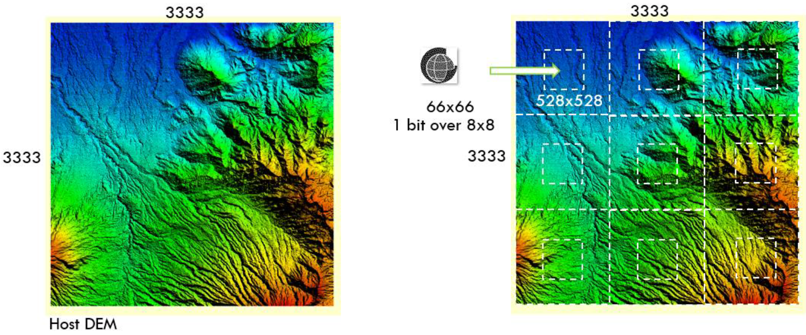
2. Materials
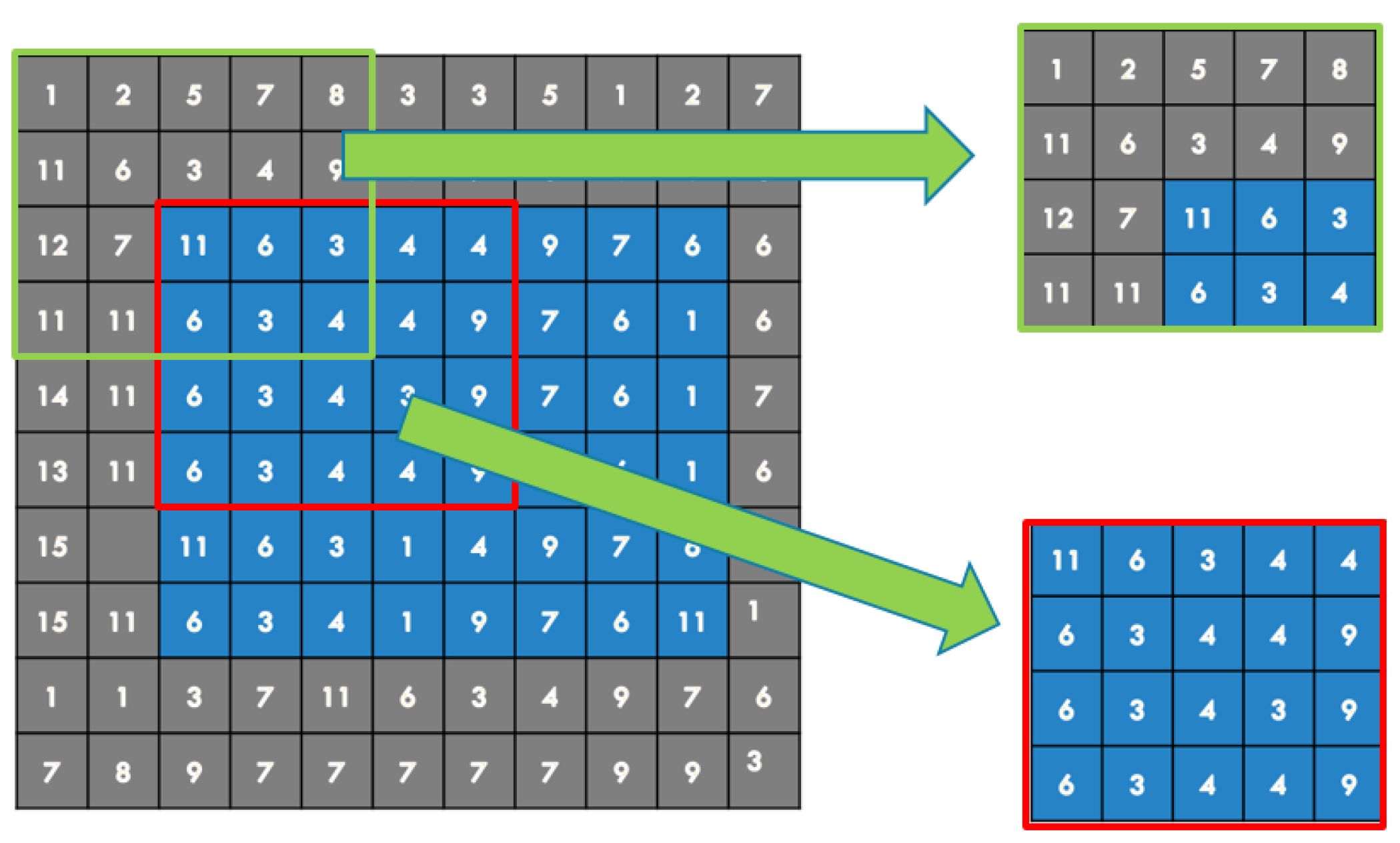
3. Methods
4. Results
- (Xupper, Yupper) and (Xlower, Ylower) are values of the georeferenced image cover with WM without clipping;
- (Xupper′, Yupper′) and (Xlower′, Ylower′) are the georeferenced image values after a clip (blue area;)
- Horizontal reference shift (Gx), Gx = |Xupper − Xupper′|;
- Shift in reference vertical direction (Gy), Gy = |Yupper − Yupper′|.
- Nx is the number of pixels horizontally from the original image before clipping;
- Ny is the number of pixels in the vertical direction of the original image before clipping;
- deltaGx = |Xupper − Xlower|;
- deltaGy = |Yupper − Ylower|;
- Horizontal ratio Rx, Rx = Nx/deltaGx;
- Vertical Ratio Ry, Ry = Ny/deltaGy.
- Shift in x-direction (Dx), Dx = Gx·Rx;
- Shift in the y (Dy) direction, Dy = Gy·Ry.
5. Discussion
6. Conclusions
Author Contributions
Funding
Institutional Review Board Statement
Informed Consent Statement
Data Availability Statement
Acknowledgments
Conflicts of Interest
References
- Nirwansyah, A.W.; Braun, B. Mapping Impact of Tidal Flooding on Solar Salt Farming in Northern Java using a Hydrodynamic Model. ISPRS Int. J. Geo-Inf. 2019, 8, 451. [Google Scholar] [CrossRef] [Green Version]
- Cummins, P.R.; Pranantyo, I.R.; Pownall, J.M.; Griffin, J.D.; Meilano, I.; Zhao, S. Earthquakes and tsunamis caused by low-angle normal faulting in the Banda Sea, Indonesia. Nat. Geosci. 2020, 13, 312–318. [Google Scholar] [CrossRef]
- Nuraghnia, A.; Windupranata, W.; Hakim, A.R.; Nusantara, C.A.D.S. Poerbandono Modeling of tide in the Java sea coastal area between Jakarta and Cirebon, Indonesia: Bathymetric data source and sensitivity tests due to bottom roughness and boundary condition. IOP Conf. Ser. Earth Environ. Sci. 2021, 777, 012034. [Google Scholar] [CrossRef]
- Wasster, L.; Holdgraf, C.; Morrissey, M. About the Geotiff (.tif) Raster File Format: Raster Data in Python. Earth Data Sci.-Earth Lab. 19 August 2021. Available online: https://www.earthdatascience.org/courses/use-data-open-source-python/intro-raster-data-python/fundamentals-raster-data/intro-to-the-geotiff-file-format/ (accessed on 24 January 2022).
- NASA. GeoTIFF. Earth Data; NASA: Washington, DC, USA, 2021.
- Mahammad, S.S.; Ramakrishnan, R. GeoTIFF-A standard image file format for GIS applications. In Proceedings of the Map India Conference 2003: Image Processing & Interpretation, Hyderabad, India, 17–20 December 2003. [Google Scholar]
- Huang, F.; Zhao, H.; Li, B.; Lv, Z. Watermarking Massive Remote Sensor Images in Parallel. In Proceedings of the 2010 International Conference on Computational Intelligence and Software Engineering, Wuhan, China, 10–12 December 2010; pp. 1–4. [Google Scholar]
- Amhar, F. The problematics of Indonesian geoportal and its future strategies. In Proceedings of the 39th Asian Conference on Remote Sensing, Kuala Lumpur, Malaysia, 15–19 October 2019; pp. 1868–1877. [Google Scholar]
- Zhou, Q.; Zhu, C.; Ren, N. Zero Watermarking for the TIN DEM Data Based on the Edge Length. ISPRS Int. J. Geo-Inf. 2021, 10, 559. [Google Scholar] [CrossRef]
- AbouEl-Seoud, S.; Abu Rumman, N.; Taj-Eddin, I.A.T.F.; Khatatneh, K.F.; Gütl, C. Robust Digital Watermarking for Compressed 3D Models based on Polygonal Representation. Int. J. Comput. Appl. 2013, 61, 1–14. [Google Scholar] [CrossRef]
- Bors, A.G.; Pitas, I. Image watermarking using DCT domain constraints. In Proceedings of the 3rd IEEE International Conference on Image Processing, Lausanne, Switzerland, 19 September 1996; pp. 231–234. [Google Scholar]
- Cho, J.-W.; Prost, R.; Jung, H.-Y. An Oblivious Watermarking for 3-D Polygonal Meshes Using Distribution of Vertex Norms. IEEE Trans. Signal Process. 2007, 55, 142–155. [Google Scholar] [CrossRef] [Green Version]
- Kanai, S.; Date, H.; Kishinami, T. Digital Watermarking for 3D Polygons using Multiresolution Wavelet Decomposition. In Proceedings of the Sixth IFIP WG 5.2/GI Int. Work. Geom. Model. Fundam. Appl., Tokyo, Japan, 1–4 December 1998; pp. 296–307. [Google Scholar]
- Li, L.; Zhang, D.; Pan, Z.; Shi, J.; Zhou, K.; Ye, K. Watermarking 3D mesh by spherical parameterization. Comput. Graph. 2004, 28, 981–989. [Google Scholar] [CrossRef]
- Ohbuchi, R.; Masuda, H.; Aono, M. Watermarking three-dimensional polygonal models through geometric and topological modifications. IEEE J. Sel. Areas Commun. 1998, 16, 551–560. [Google Scholar] [CrossRef]
- Yeo, B.-L.; Yeung, M.M. Watermarking 3D objects for verification. IEEE Comput. Graph. Appl. 1999, 19, 36–45. [Google Scholar] [CrossRef]
- Yin, K.; Pan, Z.; Shi, J.; Zhang, D. Robust mesh watermarking based on multiresolution processing. Comput. Graph. 2001, 25, 409–420. [Google Scholar] [CrossRef]
- Yamni, M.; Daoui, A.; El, O.; Karmouni, H.; Sayyouri, M.; Qjidaa, H.; Flusser, J. Fractional Charlier moments for image reconstruction and image watermarking. Signal Process. 2020, 171, 107509. [Google Scholar] [CrossRef]
- Tsougenis, E.D.; Papakostas, G.A.; Koulouriotis, D.E.; Tourassis, V.D. The Journal of Systems and Software Performance evaluation of moment-based watermarking methods: A review. J. Syst. Softw. 2012, 85, 1864–1884. [Google Scholar] [CrossRef]
- BIG. Regulation of Head of the Geospatial Information Agency (Badan Informasi Geospasial) Number 6 of 2018 about the Amendment to the Regulation of Head of the Geospatial Information Agency of Number 15 of 2014 for Technical Guidelines for Accuracy of Base Map. Indonesia. 2018. Available online: https://jdihn.go.id/files/217/27330968 (accessed on 10 February 2022).
- Amhar, F. Quality Test Various Existing DEM in Indonesia Toward 10 Meter National DEM. ISPRS-Int. Arch. Photogramm. Remote Sens. Spat. Inf. Sci. 2016, XLI-B4, 111–116. [Google Scholar] [CrossRef] [Green Version]
- Fenrich, K. Securing Your Control System. Power Eng. 2008, 112, 11. Available online: https://www.controlglobal.com/assets/knowledge_centers/abb/assets/abb_secure_control_sys.pdf (accessed on 24 January 2022).
- Fornaro, C.; Sanna, A. Public key watermarking for authentication of CSG models. Comput. Aided Des. 2000, 32, 727–735. [Google Scholar] [CrossRef]
- Praun, E.; Hoppe, H.; Finkelstein, A. Robust Mesh Watermarking. In Proceedings of the 26th Annual Conference on Computer Graphics and Interactive Techniques, Broadway, NY, USA, 8–13 August 1999; pp. 49–57. [Google Scholar] [CrossRef] [Green Version]
- Ohbuchi, R.; Masuda, H.; Aono, M. A shape-preserving data embedding algorithm for NURBS curves and surfaces. In Proceedings of the Computer Graphics International CGI-99, Canmore, AL, Canada, 7–11 June 1999; pp. 180–187. [Google Scholar]
- Xu, Y.; Zhang, S.; Li, J.; Liu, H.; Zhu, H. Extracting Terrain Texture Features for Landform Classification Using Wavelet Decomposition. ISPRS Int. J. Geo-Inf. 2021, 10, 658. [Google Scholar] [CrossRef]
- Doglioni, A.; Simeone, V. Geomorphometric analysis based on discrete wavelet transform. Environ. Earth Sci. 2014, 71, 3095–3108. [Google Scholar] [CrossRef]
- Stankovic, S.; Djurovic, I.; Pitas, I. Watermarking in the space/spatial-frequency domain using two-dimensional Radon-Wigner distribution. IEEE Trans. Image Process. 2001, 10, 650–658. [Google Scholar] [CrossRef] [PubMed]
- Zhang, X.; Feng, J.; Lo, K. Image watermarking using tree-based spatial-frequency feature of wavelet transform. J. Vis. Commun. Image Represent. 2003, 14, 474–491. [Google Scholar] [CrossRef]
- Malik, G. Analysis of Watermarking Techniques. Int. J. Comput. Appl. 2016, 138, 30–32. [Google Scholar] [CrossRef]
- Abubahia, A.; Cocea, M. Evaluating the topological quality of watermarked vector maps. Appl. Soft Comput. 2018, 71, 849–860. [Google Scholar] [CrossRef] [Green Version]
- Shrestha, B.; O’Hara, C.G.; Younan, N.H. JPEG2000: Image Quality Metrics. In Proceedings of the ASPRS 2005 Annual Conference, Baltimore, MD, USA, 7–11 March 2005. [Google Scholar]
- Li, Y.-M.; Wei, D.; Zhang, L. Double-encrypted watermarking algorithm based on cosine transform and fractional Fourier transform in invariant wavelet domain. Inf. Sci. 2021, 551, 205–227. [Google Scholar] [CrossRef]
- Matlab, “2-D DCT,” Math Works. Available online: https://www.mathworks.com/help/vision/ref/2ddct.html (accessed on 24 January 2022).
- Fazli, S.; Moeini, M. A robust image watermarking method based on DWT, DCT, and SVD using a new technique for correction of main geometric attacks. Optik 2016, 127, 964–972. [Google Scholar] [CrossRef]
- Islam, S.M.M.; Debnath, R.; Hossain, S.K.A. DWT Based Digital Watermarking Technique and its Robustness on Image Rotation, Scaling, JPEG compression, Cropping and Multiple Watermarking. In Proceedings of the 2007 International Conference on Information and Communication Technology, Bangalore, India, 15–16 December 2007; pp. 246–249. [Google Scholar]
- Ruswiansari, M.; Novianti, A.; Wirawan, W. Implementation Discrete Wavelet Transform (DWT) And Singular Value Decomposition (SVD) on Image Watermarking. J. Elektro dan Telekomun. Terap. 2016, 3. [Google Scholar] [CrossRef]
- Gourrame, K.; Douzi, H.; Harba, R.; Ros, F.; El Hajji, M.; Riad, R.; Amar, M. Robust Print-cam Image Watermarking in Fourier Domain. In Proceedings of the Image and Signal Processing: 7th International Conference, ICISP 2016, Trois-Rivières, QC, Canada, 30 May–1 June 2016; Springer: Berlin/Heidelberg, Germany, 2016; pp. 356–365. [Google Scholar]
- Woo, C.-S.; Du, J.; Pham, B. Geometric Invariant Domain for Image Watermarking. In International Workshop on Digital Watermarking; Springer: Berlin/Heidelberg, Germany, 2006; pp. 294–307. [Google Scholar]
- Li, L.; Bai, R.; Lu, J.; Zhang, S.; Chang, C.-C. A Watermarking Scheme for Color Image Using Quaternion Discrete Fourier Transform and Tensor Decomposition. Appl. Sci. 2021, 11, 5006. [Google Scholar] [CrossRef]


| Scale | Contour Interval (Meters) | Topographic Map Accuration | |||||
|---|---|---|---|---|---|---|---|
| Quality of First Class | Quality of Second Class | Quality of Third Class | |||||
| Circular Error 90% (CE90) of Horizontal in Meters | Linear Error 90% (LE90) of Vertical in Meters | Circular Error 90% (CE90) of Horizontal in Meters | Linear Error 90% (LE90) of Vertical in Meters | Circular Error 90% (CE90) of Horizontal in Meters | Linear Error 90% (LE90) of Vertical in Meters | ||
| 1:1,000,000 | 400 | 300 | 200 | 600 | 300 | 900 | 400 |
| 1:500,000 | 200 | 150 | 100 | 300 | 150 | 450 | 200 |
| 1:250,000 | 100 | 75 | 50 | 150 | 75 | 225 | 100 |
| 1:100,000 | 40 | 30 | 20 | 60 | 30 | 90 | 40 |
| 1:50,000 | 20 | 15 | 10 | 30 | 15 | 45 | 20 |
| 1:25,000 | 10 | 7.5 | 5 | 15 | 7.5 | 22.5 | 10 |
| 1:10,000 | 4 | 3 | 2 | 6 | 3 | 9 | 4 |
| 1:5000 | 2 | 1.5 | 1 | 3 | 1.5 | 4.5 | 2 |
| 1:2500 | 1 | 0.75 | 0.5 | 1.5 | 0.75 | 2.3 | 1 |
| 1:1000 | 0,4 | 0.3 | 0.2 | 0.6 | 0.3 | 0.9 | 0.4 |
| Accuration | Quality of First Class | Quality of Second Class | Quality of Third Class |
|---|---|---|---|
| Horizontal | 0.2 mm × map scale numbers | 0.3 mm × map scale numbers | 0.5 mm × map scale numbers |
| Vertical | 0.5 × contour interval numbers | 1.5 × contour interval numbers of the 1st class | 2.5 × contour interval numbers of the 1st class |
| Item | Description | DEMNAS |
|---|---|---|
| File name | DEMNAS_xxxx-yyy-v1.0.tif for 1:25k. xxxx-yy shows the RBI map sheet number, and v1.0 indicates the 1.0 version release. DEMNAS_1209-14 (typically undulating to the moderately sloping area—highlands), DEMNAS_1209-42 (typically flat to the undulating area), and DEMNAS_1209-44 (typically flat area—coastal plains) are used. |  |
| Resolution | 0.27 arcsecond | |
| Datum | EGM2008 vertical datum | |
| Coordinate system | Geographic | |
| Format | 32-bit float GeoTIFF | |
| Sources | The National DEM is built from several data sources, including IFSAR data (5 m resolution) and ALOS PALSAR (11.25 m resolution), by adding Masspoint data from stereo plotting results | |
| Information | DEMNAS data for the area used are compatible for large- to medium-scale mapping (≤1:10,000 to 1:250.000) |
| Value | Calculation | Attribute |
|---|---|---|
| (Xupper, Yupper) | - | Suppose (100,100) |
| (Xlower, Ylower) | - | Suppose (210,200) |
| (Xupper′, Yupper′) | - | Suppose (120,120) |
| Nx | - | 11 |
| Ny | - | 10 |
| deltaGx | = |Xupper − Xlower| = |100 − 210| = 110 | 110 |
| deltaGy | = |Yupper − Ylower| = |100 − 200| = 100 | 100 |
| Rx | = Nx/deltaGx = 11/110 | 0.1 |
| Ry | = Ny/deltaGy = 10/100 | 0.1 |
| Gx | = |Xupper − Xupper′| = |100 − 120| = 20 | 20 |
| Gy | = |Yupper − Yupper′| = |100 − 120| = 20 | 20 |
| Dx | = Gx·Rx = 20·(0.1) = 2 | 2 |
| Dy | = Gy·Ry = 20·(0.1) = 2 | 2 |
| Nr. | Watermark Image File | Dimension (Pixels) | Image |
|---|---|---|---|
| 1 | Logo_BIG_Black_33x33.png | 33 × 33 |  |
| 2 | Logo_BIG_Black_66x66.png | 66 × 66 |  |
| 3 | Logo_BIG_Black_132x132.png | 132 × 132 |  |
| 4 | BIG_Black_66x66.png | 66 × 66 |  |
| 5 | BIG_White_66x66.png | 66 × 66 |  |
| Nr. | Host DEM | Watermark Image | Watermarked DEM | Extraction Results |
|---|---|---|---|---|
| 1 |  3333 × 3333 pixels |  33 × 33 pixels |  3333 × 3333 pixels |  99 × 99 pixels |
| 2 |  3333 × 3333 pixels |  66 × 66 pixels |  3333 × 3333 pixels |  198 × 198 pixels |
| 3 |  3333 × 3333 pixels |  132 × 132 pixels |  3333 × 3333 pixels |  396 × 396 pixels |
| 4 |  3333 × 3333 pixels |  66 × 66 pixels |  3333 × 3333 pixels |  198 × 198 pixels |
| 5 |  3333 × 3333 pixels |  66 × 66 pixels |  3333 × 3333 pixels |  198 × 198 pixels |
| Nr. | Host DEM | Watermarked DEM | Watermark Image | Technique | Extracted Watermark |
|---|---|---|---|---|---|
| 1 | DEMNAS_1209-44_v1.0.tif | DCT_DEMNAS_1209-44_v1.0_berWM_Logo_BIG33.tif | Logo_BIG_Black_33x33.png | DCT | 100 |
| 2 | DEMNAS_1209-44_v1.0.tif | DCT_DEMNAS_1209-44_v1.0_berWM_Logo_BIG66.tif | Logo_BIG_Black_66x66.png | DCT | 100 |
| 3 | DEMNAS_1209-44_v1.0.tif | DCT_DEMNAS_1209-44_v1.0_berWM_Logo_BIG132.tif | Logo_BIG_Black_132x132.png | DCT | 100 |
| 4 | DEMNAS_1209-44_v1.0.tif | DCT_DEMNAS_1209-44_v1.0_berWM66_BIG_Black.tif | BIG_Black_66x66.png | DCT | 100 |
| 5 | DEMNAS_1209-44_v1.0.tif | DCT_DEMNAS_1209-44_v1.0_berWM66_BIG_White.tif | BIG_White_66x66.png | DCT | 100 |
| 6 | DEMNAS_1209-44_v1.0.tif | DFT_DEMNAS_1209-44_v1.0_berWM_Logo_BIG33.tif | Logo_BIG_Black_33x33.png | DFT | 84.30 |
| 7 | DEMNAS_1209-44_v1.0.tif | DFT_DEMNAS_1209-44_v1.0_berWM_Logo_BIG66.tif | Logo_BIG_Black_66x66.png | DFT | 85.97 |
| 8 | DEMNAS_1209-44_v1.0.tif | DFT_DEMNAS_1209-44_v1.0_berWM_Logo_BIG132.tif | Logo_BIG_Black_132x132.png | DFT | 86.01 |
| 9 | DEMNAS_1209-44_v1.0.tif | DFT_DEMNAS_1209-44_v1.0_berWM66_BIG_Black.tif | BIG_Black_66x66.png | DFT | 94.21 |
| 10 | DEMNAS_1209-44_v1.0.tif | DFT_DEMNAS_1209-44_v1.0_berWM66_BIG_White.tif | BIG_White_66x66.png | DFT | 90.50 |
| 11 | DEMNAS_1209-14_v1.0.tif | DEMNAS_1209-14_di_33.tif | Logo_BIG_Black_33x33_14_rec.png | DWT-DCT | 100 |
| 12 | DEMNAS_1209-14_v1.0.tif | DEMNAS_1209-14_di_66.tif | Logo_BIG_Black_66x66_14_rec.png | DWT-DCT | 100 |
| 13 | DEMNAS_1209-14_v1.0.tif | DEMNAS_1209-14_di_132.tif | Logo_BIG_Black_132x132_14_rec.png | DWT-DCT | 100 |
| 14 | DEMNAS_1209-14_v1.0.tif | DEMNAS_1209-14_di_b.tif | BIG_Black_66x66.png | DWT-DCT | 100 |
| 15 | DEMNAS_1209-42_v1.0.tif | DEMNAS_1209-42_di_33.tif | Logo_BIG_Black_33x33_42_rec.png | DWT-DCT | 100 |
| 16 | DEMNAS_1209-42_v1.0.tif | DEMNAS_1209-42_di_66.tif | Logo_BIG_Black_66x66_42_rec.png | DWT-DCT | 100 |
| 17 | DEMNAS_1209-42_v1.0.tif | DEMNAS_1209-42_di_132.tif | Logo_BIG_Black_132x132_42_rec.png | DWT-DCT | 100 |
| 18 | DEMNAS_1209-42_v1.0.tif | DEMNAS_1209-42_di_b.tif | BIG_Black_66x66.png | DWT-DCT | 100 |
| 19 | DEMNAS_1209-44_v1.0.tif | DEMNAS_1209-44_di_33.tif | Logo_BIG_Black_33x33_14_rec.png | DWT-DCT | 100 |
| 20 | DEMNAS_1209-44_v1.0.tif | DEMNAS_1209-44_di_66.tif | Logo_BIG_Black_66x66_14_rec.png | DWT-DCT | 100 |
| 21 | DEMNAS_1209-44_v1.0.tif | DEMNAS_1209-44_di_132.tif | Logo_BIG_Black_132x132_14_rec.png | DWT-DCT | 100 |
| 22 | DEMNAS_1209-44_v1.0.tif | DEMNAS_1209-44_di_b.tif | BIG_Black_66x66.png | DWT-DCT | 100 |
| Nr | Host DEM | Watermarked DEM | Watermark Image | Technique | Max Delta (m) |
|---|---|---|---|---|---|
| 1 | DEMNAS_1209-44_v1.0.tif | DCT_DEMNAS_1209-44_v1.0_berWM_Logo_BIG33.tif | Logo_BIG_Black_33x33.png | DCT | 0.021 |
| 2 | DEMNAS_1209-44_v1.0.tif | DCT_DEMNAS_1209-44_v1.0_berWM_Logo_BIG66.tif | Logo_BIG_Black_66x66.png | DCT | 0.021 |
| 3 | DEMNAS_1209-44_v1.0.tif | DCT_DEMNAS_1209-44_v1.0_berWM_Logo_BIG132.tif | Logo_BIG_Black_132x132.png | DCT | 0.022 |
| 4 | DEMNAS_1209-44_v1.0.tif | DCT_DEMNAS_1209-44_v1.0_berWM66_BIG_Black.tif | BIG_Black_66x66.png | DCT | 0.023 |
| 5 | DEMNAS_1209-44_v1.0.tif | DCT_DEMNAS_1209-44_v1.0_berWM66_BIG_White.tif | BIG_White_66x66.png | DCT | 0.023 |
| 6 | DEMNAS_1209-44_v1.0.tif | DFT_DEMNAS_1209-44_v1.0_berWM_Logo_BIG33.tif | Logo_BIG_Black_33x33.png | DFT | 4.874 |
| 7 | DEMNAS_1209-44_v1.0.tif | DFT_DEMNAS_1209-44_v1.0_berWM_Logo_BIG66.tif | Logo_BIG_Black_66x66.png | DFT | 4.578 |
| 8 | DEMNAS_1209-44_v1.0.tif | DFT_DEMNAS_1209-44_v1.0_berWM_Logo_BIG132.tif | Logo_BIG_Black_132x132.png | DFT | 4.713 |
| 9 | DEMNAS_1209-44_v1.0.tif | DFT_DEMNAS_1209-44_v1.0_berWM66_BIG_Black.tif | BIG_Black_66x66.png | DFT | 5.643 |
| 10 | DEMNAS_1209-44_v1.0.tif | DFT_DEMNAS_1209-44_v1.0_berWM66_BIG_White.tif | BIG_White_66x66.png | DFT | 2.064 |
| 11 | DEMNAS_1209-14_v1.0.tif | DEMNAS_1209-14_di_33.tif | Logo_BIG_Black_33x33_14_rec.png | DWT-DCT | 1.139 |
| 12 | DEMNAS_1209-14_v1.0.tif | DEMNAS_1209-14_di_66.tif | Logo_BIG_Black_66x66_14_rec.png | DWT-DCT | 1.160 |
| 13 | DEMNAS_1209-14_v1.0.tif | DEMNAS_1209-14_di_132.tif | Logo_BIG_Black_132x132_14_rec.png | DWT-DCT | 1.157 |
| 14 | DEMNAS_1209-14_v1.0.tif | DEMNAS_1209-14_di_b.tif | BIG_Black_66x66.png | DWT-DCT | 1.121 |
| 15 | DEMNAS_1209-42_v1.0.tif | DEMNAS_1209-42_di_33.tif | Logo_BIG_Black_33x33_42_rec.png | DWT-DCT | 1.102 |
| 16 | DEMNAS_1209-42_v1.0.tif | DEMNAS_1209-42_di_66.tif | Logo_BIG_Black_66x66_42_rec.png | DWT-DCT | 1.110 |
| 17 | DEMNAS_1209-42_v1.0.tif | DEMNAS_1209-42_di_132.tif | Logo_BIG_Black_132x132_42_rec.png | DWT-DCT | 1.115 |
| 18 | DEMNAS_1209-42_v1.0.tif | DEMNAS_1209-42_di_b.tif | BIG_Black_66x66.png | DWT-DCT | 1.101 |
| 19 | DEMNAS_1209-44_v1.0.tif | DEMNAS_1209-44_di_33.tif | Logo_BIG_Black_33x33_14_rec.png | DWT-DCT | 1.088 |
| 20 | DEMNAS_1209-44_v1.0.tif | DEMNAS_1209-44_di_66.tif | Logo_BIG_Black_66x66_14_rec.png | DWT-DCT | 1.096 |
| 21 | DEMNAS_1209-44_v1.0.tif | DEMNAS_1209-44_di_132.tif | Logo_BIG_Black_132x132_14_rec.png | DWT-DCT | 1.117 |
| 22 | DEMNAS_1209-44_v1.0.tif | DEMNAS_1209-44_di_b.tif | BIG_Black_66x66.png | DWT-DCT | 1.092 |
| Nr. | Host DEM | Watermarked DEM | Watermark Image | Technique | PSNR |
|---|---|---|---|---|---|
| 1 | DEMNAS_1209-44_v1.0.tif | DCT_DEMNAS_1209-44_v1.0_berWM_Logo_BIG33.tif | Logo_BIG_Black_33x33.png | DCT | 93.514 |
| 2 | DEMNAS_1209-44_v1.0.tif | DCT_DEMNAS_1209-44_v1.0_berWM_Logo_BIG66.tif | Logo_BIG_Black_66x66.png | DCT | 87.601 |
| 3 | DEMNAS_1209-44_v1.0.tif | DCT_DEMNAS_1209-44_v1.0_berWM_Logo_BIG132.tif | Logo_BIG_Black_132x132.png | DCT | 81.507 |
| 4 | DEMNAS_1209-44_v1.0.tif | DCT_DEMNAS_1209-44_v1.0_berWM66_BIG_Black.tif | BIG_Black_66x66.png | DCT | 91.452 |
| 5 | DEMNAS_1209-44_v1.0.tif | DCT_DEMNAS_1209-44_v1.0_berWM66_BIG_White.tif | BIG_White_66x66.png | DCT | 83.814 |
| 6 | DEMNAS_1209-44_v1.0.tif | DFT_DEMNAS_1209-44_v1.0_berWM_Logo_BIG33.tif | Logo_BIG_Black_33x33.png | DFT | 80.772 |
| 7 | DEMNAS_1209-44_v1.0.tif | DFT_DEMNAS_1209-44_v1.0_berWM_Logo_BIG66.tif | Logo_BIG_Black_66x66.png | DFT | 80.320 |
| 8 | DEMNAS_1209-44_v1.0.tif | DFT_DEMNAS_1209-44_v1.0_berWM_Logo_BIG132.tif | Logo_BIG_Black_132x132.png | DFT | 80.427 |
| 9 | DEMNAS_1209-44_v1.0.tif | DFT_DEMNAS_1209-44_v1.0_berWM66_BIG_Black.tif | BIG_Black_66x66.png | DFT | 79.688 |
| 10 | DEMNAS_1209-44_v1.0.tif | DFT_DEMNAS_1209-44_v1.0_berWM66_BIG_White.tif | BIG_White_66x66.png | DFT | 82.604 |
| 11 | DEMNAS_1209-14_v1.0.tif | DEMNAS_1209-14_di_33.tif | Logo_BIG_Black_33x33_14_rec.png | DWT-DCT | 91.474 |
| 12 | DEMNAS_1209-14_v1.0.tif | DEMNAS_1209-14_di_66.tif | Logo_BIG_Black_66x66_14_rec.png | DWT-DCT | 84.772 |
| 13 | DEMNAS_1209-14_v1.0.tif | DEMNAS_1209-14_di_132.tif | Logo_BIG_Black_132x132_14_rec.png | DWT-DCT | 79.039 |
| 14 | DEMNAS_1209-14_v1.0.tif | DEMNAS_1209-14_di_b.tif | BIG_Black_66x66.png | DWT-DCT | 88.675 |
| 15 | DEMNAS_1209-42_v1.0.tif | DEMNAS_1209-42_di_33.tif | Logo_BIG_Black_33x33_42_rec.png | DWT-DCT | 77.585 |
| 16 | DEMNAS_1209-42_v1.0.tif | DEMNAS_1209-42_di_66.tif | Logo_BIG_Black_66x66_42_rec.png | DWT-DCT | 70.887 |
| 17 | DEMNAS_1209-42_v1.0.tif | DEMNAS_1209-42_di_132.tif | Logo_BIG_Black_132x132_42_rec.png | DWT-DCT | 65.154 |
| 18 | DEMNAS_1209-42_v1.0.tif | DEMNAS_1209-42_di_b.tif | BIG_Black_66x66.png | DWT-DCT | 74.789 |
| 19 | DEMNAS_1209-44_v1.0.tif | DEMNAS_1209-44_di_33.tif | Logo_BIG_Black_33x33_14_rec.png | DWT-DCT | 59.594 |
| 20 | DEMNAS_1209-44_v1.0.tif | DEMNAS_1209-44_di_66.tif | Logo_BIG_Black_66x66_14_rec.png | DWT-DCT | 52.897 |
| 21 | DEMNAS_1209-44_v1.0.tif | DEMNAS_1209-44_di_132.tif | Logo_BIG_Black_132x132_14_rec.png | DWT-DCT | 47.163 |
| 22 | DEMNAS_1209-44_v1.0.tif | DEMNAS_1209-44_di_b.tif | BIG_Black_66x66.png | DWT-DCT | 56.800 |
| Nr. | Host DEM | Watermarked DEM | Watermark Image | Technique | RMSE |
|---|---|---|---|---|---|
| 1 | DEMNAS_1209-44_v1.0.tif | DCT_DEMNAS_1209-44_v1.0_berWM_Logo_BIG33.tif | Logo_BIG_Black_33x33.png | DCT | 0.001129 |
| 2 | DEMNAS_1209-44_v1.0.tif | DCT_DEMNAS_1209-44_v1.0_berWM_Logo_BIG66.tif | Logo_BIG_Black_66x66.png | DCT | 0.002232 |
| 3 | DEMNAS_1209-44_v1.0.tif | DCT_DEMNAS_1209-44_v1.0_berWM_Logo_BIG132.tif | Logo_BIG_Black_132x132.png | DCT | 0.004502 |
| 4 | DEMNAS_1209-44_v1.0.tif | DCT_DEMNAS_1209-44_v1.0_berWM66_BIG_Black.tif | BIG_Black_66x66.png | DCT | 0.001432 |
| 5 | DEMNAS_1209-44_v1.0.tif | DCT_DEMNAS_1209-44_v1.0_berWM66_BIG_White.tif | BIG_White_66x66.png | DCT | 0.005342 |
| 6 | DEMNAS_1209-44_v1.0.tif | DFT_DEMNAS_1209-44_v1.0_berWM_Logo_BIG33.tif | Logo_BIG_Black_33x33.png | DFT | 0.004900 |
| 7 | DEMNAS_1209-44_v1.0.tif | DFT_DEMNAS_1209-44_v1.0_berWM_Logo_BIG66.tif | Logo_BIG_Black_66x66.png | DFT | 0.005162 |
| 8 | DEMNAS_1209-44_v1.0.tif | DFT_DEMNAS_1209-44_v1.0_berWM_Logo_BIG132.tif | Logo_BIG_Black_132x132.png | DFT | 0.005099 |
| 9 | DEMNAS_1209-44_v1.0.tif | DFT_DEMNAS_1209-44_v1.0_berWM66_BIG_Black.tif | BIG_Black_66x66.png | DFT | 0.005552 |
| 10 | DEMNAS_1209-44_v1.0.tif | DFT_DEMNAS_1209-44_v1.0_berWM66_BIG_White.tif | BIG_White_66x66.png | DFT | 0.003968 |
| 11 | DEMNAS_1209-14_v1.0.tif | DEMNAS_1209-14_di_33.tif | Logo_BIG_Black_33x33_14_rec.png | DWT-DCT | 0.003147 |
| 12 | DEMNAS_1209-14_v1.0.tif | DEMNAS_1209-14_di_66.tif | Logo_BIG_Black_66x66_14_rec.png | DWT-DCT | 0.014728 |
| 13 | DEMNAS_1209-14_v1.0.tif | DEMNAS_1209-14_di_132.tif | Logo_BIG_Black_132x132_14_rec.png | DWT-DCT | 0.055136 |
| 14 | DEMNAS_1209-14_v1.0.tif | DEMNAS_1209-14_di_b.tif | BIG_Black_66x66_14.png | DWT-DCT | 0.005996 |
| 15 | DEMNAS_1209-42_v1.0.tif | DEMNAS_1209-42_di_33.tif | Logo_BIG_Black_33x33_42_rec.png | DWT-DCT | 0.003149 |
| 16 | DEMNAS_1209-42_v1.0.tif | DEMNAS_1209-42_di_66.tif | Logo_BIG_Black_66x66_42_rec.png | DWT-DCT | 0.014726 |
| 17 | DEMNAS_1209-42_v1.0.tif | DEMNAS_1209-42_di_132.tif | Logo_BIG_Black_132x132_42_rec.png | DWT-DCT | 0.055136 |
| 18 | DEMNAS_1209-42_v1.0.tif | DEMNAS_1209-42_di_b.tif | BIG_Black_66x66_42.png | DWT-DCT | 0.005997 |
| 19 | DEMNAS_1209-44_v1.0.tif | DEMNAS_1209-44_di_33.tif | Logo_BIG_Black_33x33_44_rec.png | DWT-DCT | 0.003148 |
| 20 | DEMNAS_1209-44_v1.0.tif | DEMNAS_1209-44_di_66.tif | Logo_BIG_Black_66x66_44_rec.png | DWT-DCT | 0.014722 |
| 21 | DEMNAS_1209-44_v1.0.tif | DEMNAS_1209-44_di_132.tif | Logo_BIG_Black_132x132_44_rec.png | DWT-DCT | 0.055127 |
| 22 | DEMNAS_1209-44_v1.0.tif | DEMNAS_1209-44_di_b.tif | BIG_Black_66x66_44.png | DWT-DCT | 0.005993 |
| Nr. | Host DEM | Watermark Image | Watermarked DEM | Extraction Results |
|---|---|---|---|---|
| 1 |  3333 × 3333 pixels |  33 × 33 pixels |  3333 × 3333 pixels |  99 × 99 pixels |
| 2 |  3333 × 3333 pixels |  66 × 66 pixels |  3333 × 3333 pixels |  198 × 198 pixels |
| 3 |  3333 × 3333 pixels |  132 × 132 pixels |  3333 × 3333 pixels |  396 × 396 pixels |
| 4 |  3333 × 3333 pixels |  66 × 66 pixels |  3333 × 3333 pixels |  198 × 198 pixels |
| 5 |  3333 × 3333 pixels |  66 × 66 pixels |  3333 × 3333 pixels |  198 × 198 pixels |
| Nr. | Watermark Image File | Dimension (Pixels) | Image | Extraction Results |
|---|---|---|---|---|
| 1 | Logo_BIG_Black_66x66_14_rec.png | 66 × 66 |  |  |
| 2 | Logo_BIG_Black_66x66_42_rec.png | 66 × 66 |  |  |
| 3 | Logo_BIG_Black_66x66_44_rec.png | 66 × 66 |  |  |
| 4 | BIG_Black_66x66_44_rec | 66 × 66 |  |  |
Publisher’s Note: MDPI stays neutral with regard to jurisdictional claims in published maps and institutional affiliations. |
© 2022 by the authors. Licensee MDPI, Basel, Switzerland. This article is an open access article distributed under the terms and conditions of the Creative Commons Attribution (CC BY) license (https://creativecommons.org/licenses/by/4.0/).
Share and Cite
Amhar, F.; Giri, E.P.; Silalahi, F.E.S.; Neyman, S.N.; Anggrahito; Ramdani, D.; Jaya, D.; Sutrisno, D.; Kolopaking, S.A.; Rachma, T.R.N.; et al. Ownership Protection on Digital Elevation Model (DEM) Using Transform-Based Watermarking. ISPRS Int. J. Geo-Inf. 2022, 11, 200. https://doi.org/10.3390/ijgi11030200
Amhar F, Giri EP, Silalahi FES, Neyman SN, Anggrahito, Ramdani D, Jaya D, Sutrisno D, Kolopaking SA, Rachma TRN, et al. Ownership Protection on Digital Elevation Model (DEM) Using Transform-Based Watermarking. ISPRS International Journal of Geo-Information. 2022; 11(3):200. https://doi.org/10.3390/ijgi11030200
Chicago/Turabian StyleAmhar, Fahmi, Endang Purnama Giri, Florence Elfriede Sinthauli Silalahi, Shelvie Nidya Neyman, Anggrahito, Dadan Ramdani, Danang Jaya, Dewayany Sutrisno, Sandi Adhitya Kolopaking, Tia Rizka Nuzula Rachma, and et al. 2022. "Ownership Protection on Digital Elevation Model (DEM) Using Transform-Based Watermarking" ISPRS International Journal of Geo-Information 11, no. 3: 200. https://doi.org/10.3390/ijgi11030200
APA StyleAmhar, F., Giri, E. P., Silalahi, F. E. S., Neyman, S. N., Anggrahito, Ramdani, D., Jaya, D., Sutrisno, D., Kolopaking, S. A., Rachma, T. R. N., & Murdaningsih. (2022). Ownership Protection on Digital Elevation Model (DEM) Using Transform-Based Watermarking. ISPRS International Journal of Geo-Information, 11(3), 200. https://doi.org/10.3390/ijgi11030200