
Crop Identification Based on Multi-Temporal Active and Passive Remote Sensing Images


Abstract
:1. Introduction
2. Materials and Methods
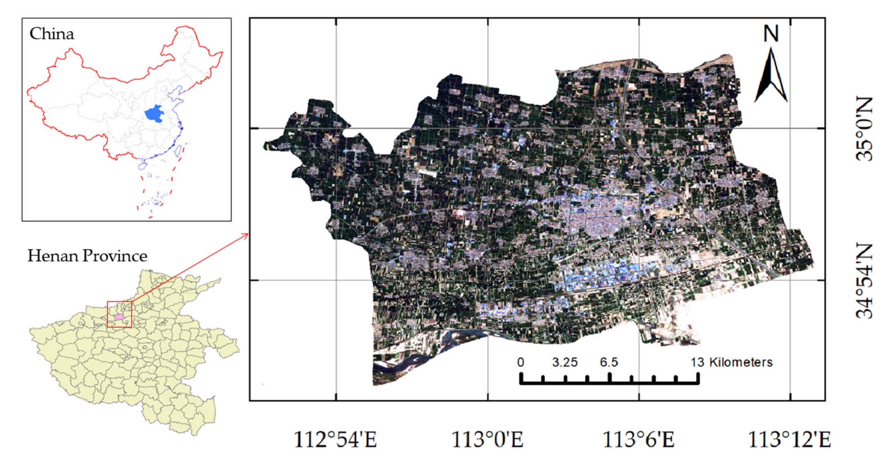
2.1. Study Area
2.2. Sentinel-1, -2 Data
2.3. Field Data
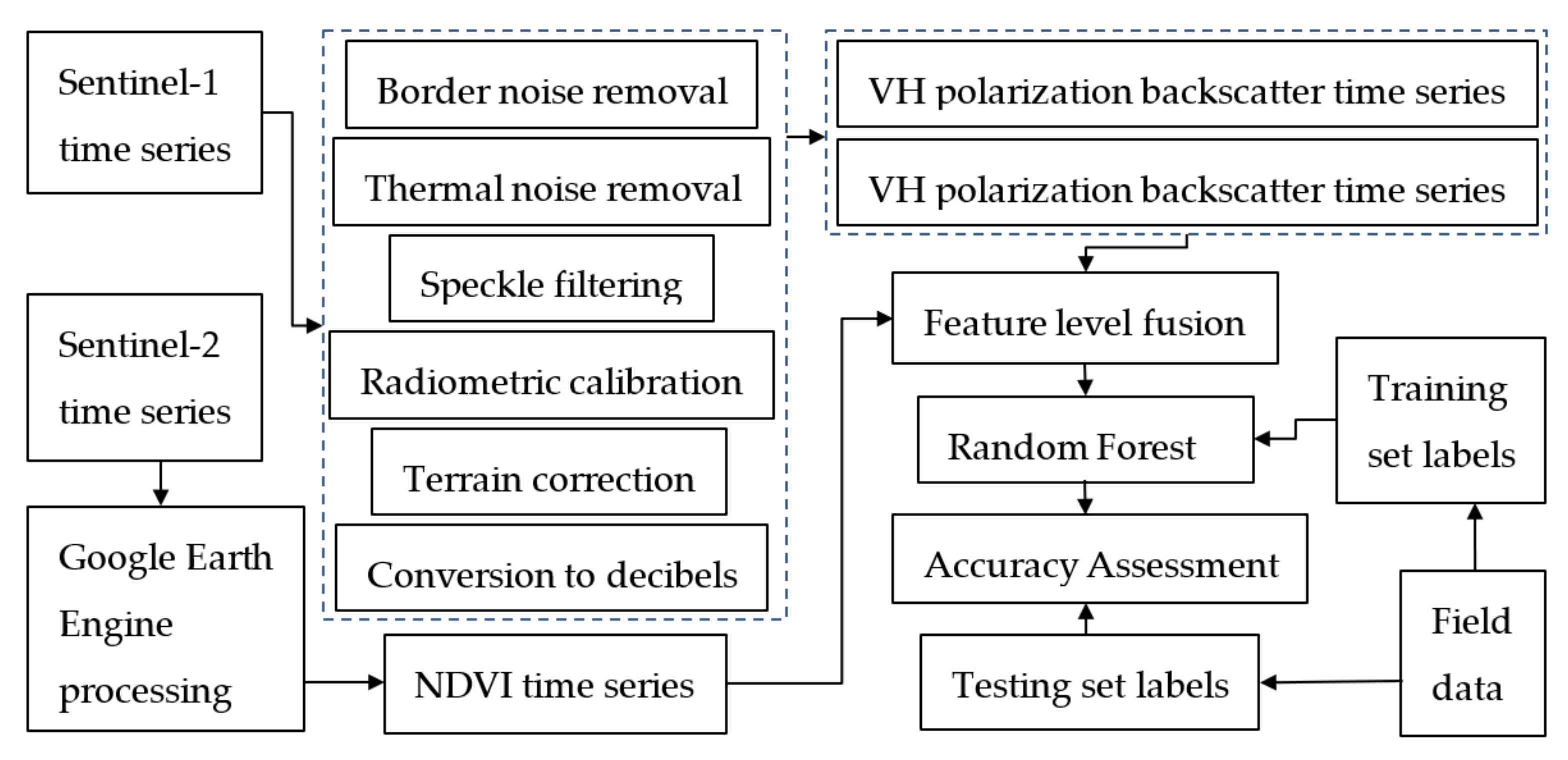
2.4. Methods
2.4.1. Time-Series Datasets
2.4.2. Fusion of Active and Passive Remote Sensing
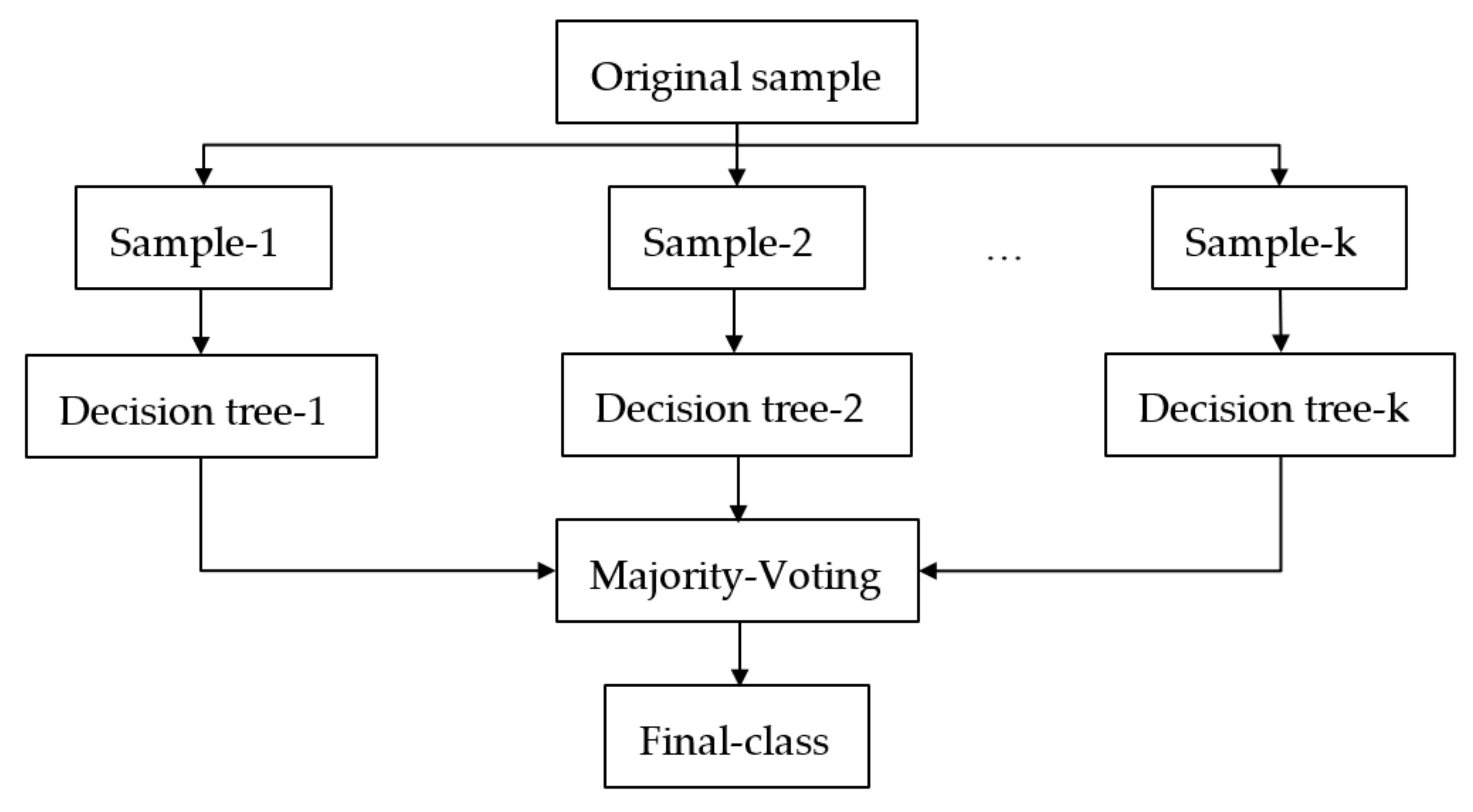
2.4.3. Random Forest Classifier
- (1)
- A sample set with capacity N was extracted N times with one-at-a-time replacement until N samples were formed, which were then used as the samples at the root node of the decision tree to train the decision tree;
- (2)
- Each sample has M features. When the decision tree needed to be split, m << M features were selected at random from these M features. The feature with the best classification ability of these m features was selected as the splitting feature of the node;
- (3)
- To form the decision tree, each node was split as per step 2 until the feature selected by the child node was the feature used when the parent node was split; that is, the child node was a leaf node. At this point, the splitting stopped. Note that each tree grew to the maximum extent, and no pruning was done during the formation of the decision tree; and
- (4)
- This study followed steps 1–3 to build k decision trees to form a RF. Assuming that the set of categories was {, , …, }, the prediction output of in sample x was expressed as an N-dimensional vector , where represented the output of in category , and the decision was made by the majority voting (Equation (2)).
2.4.4. Training and Prediction
2.4.5. Accuracy
3. Results
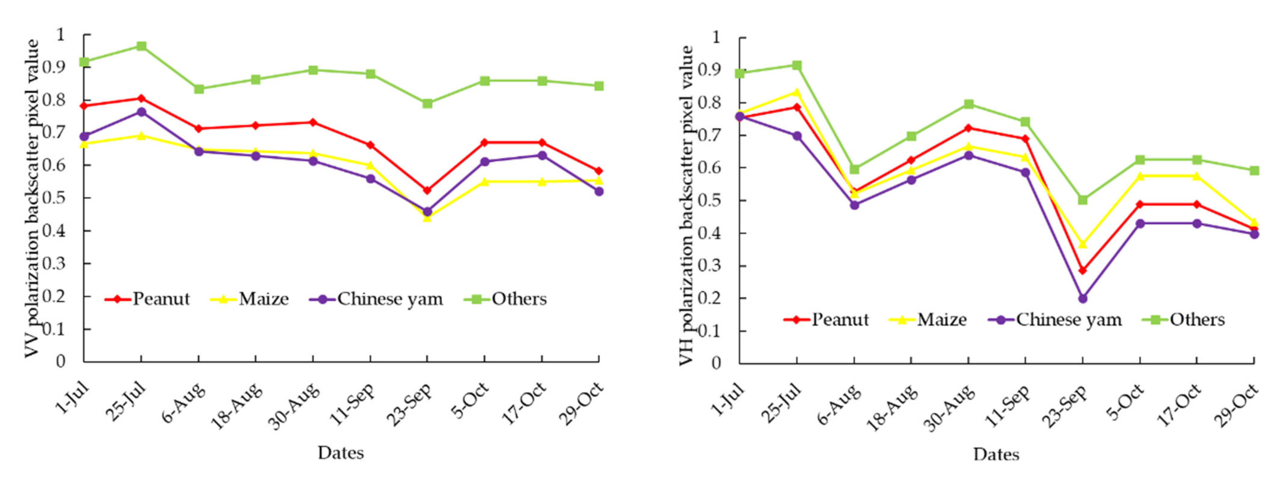
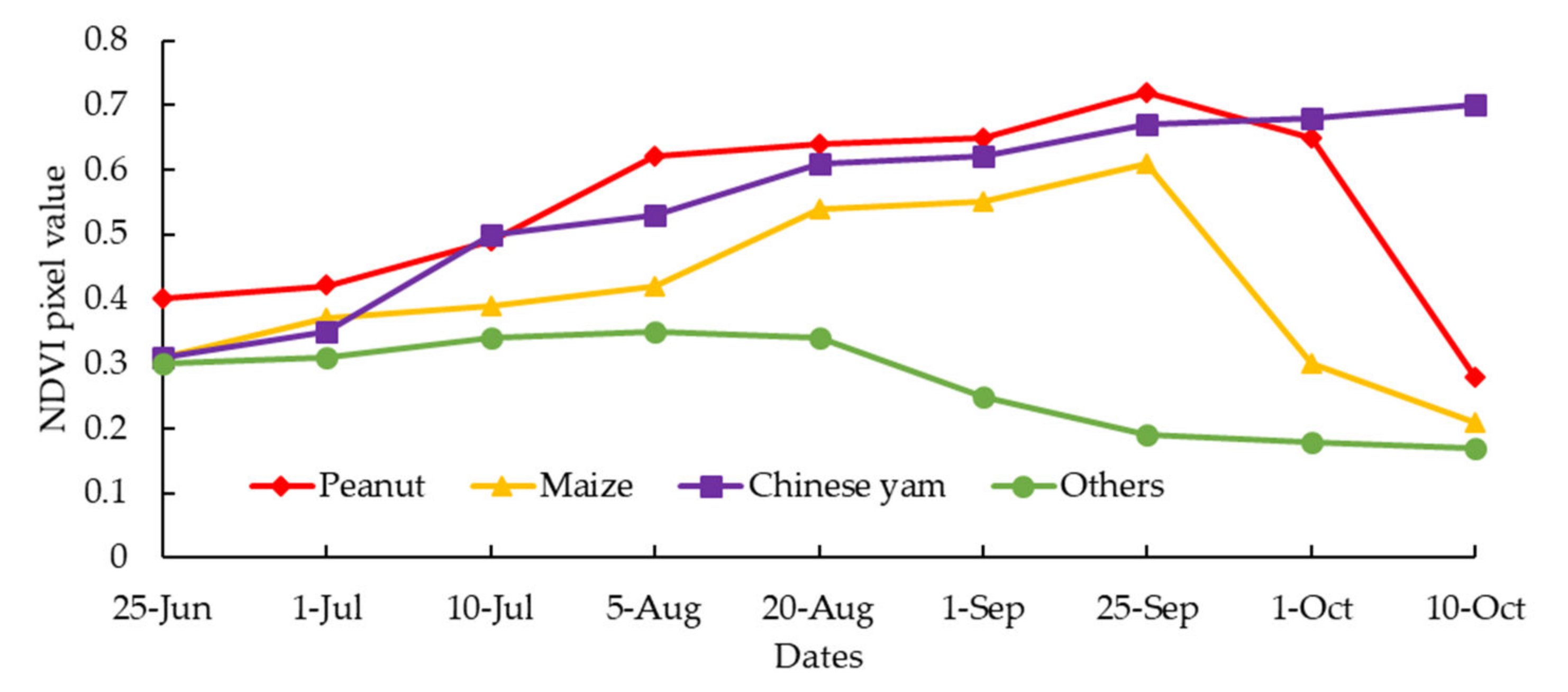
3.1. Time Series Curve
3.2. Accuracy
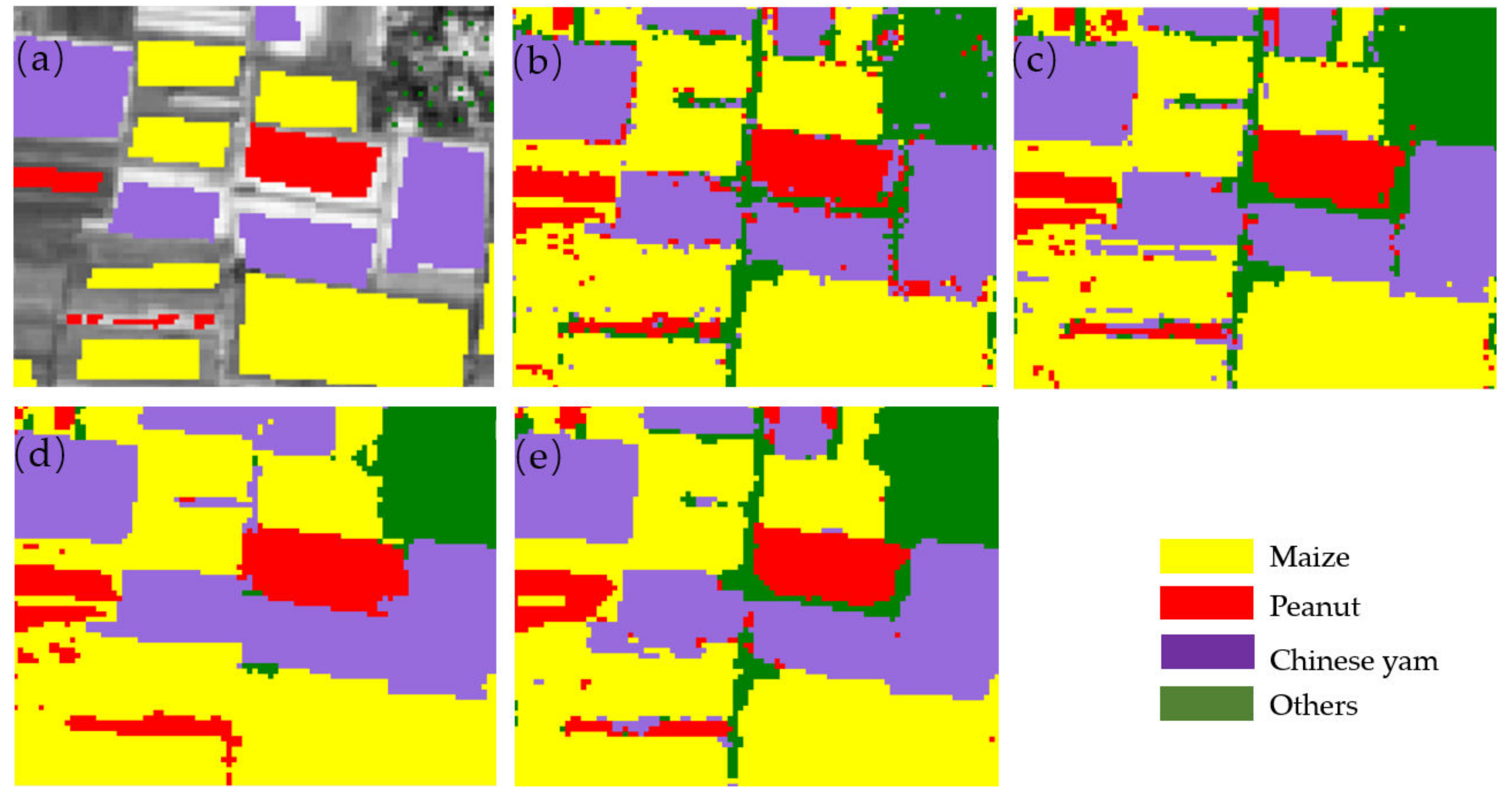
3.3. Comparison of Details of Prediction
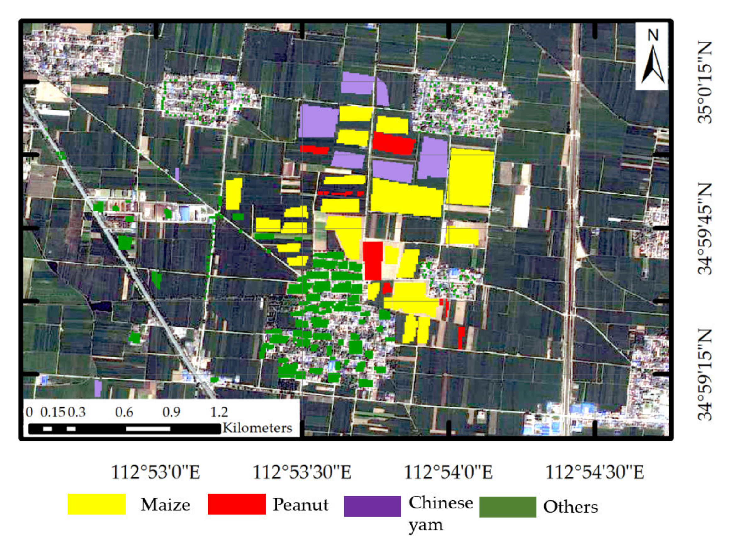
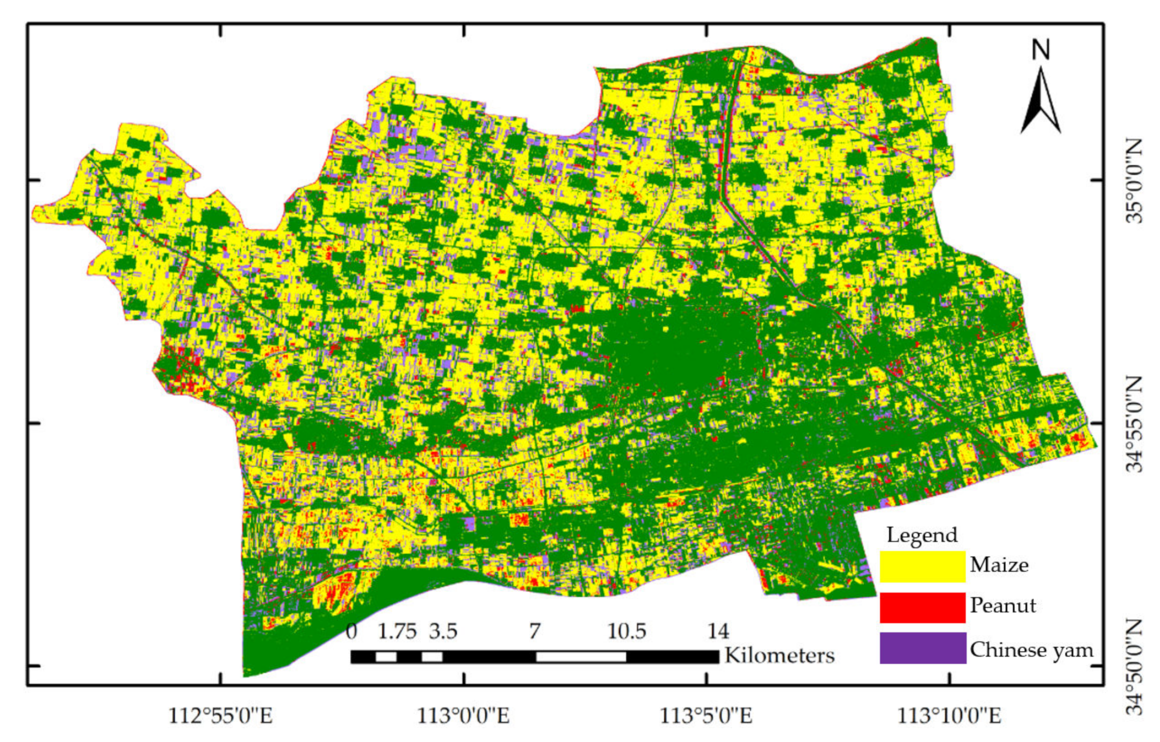
3.4. Crop Mapping
3.5. Comparison with Government Data
4. Discussion of Results
5. Conclusions
Author Contributions
Funding
Institutional Review Board Statement
Informed Consent Statement
Data Availability Statement
Acknowledgments
Conflicts of Interest
References
- Ayanlade, A.; Radeny, M. COVID-19 and food security in Sub-Saharan Africa: Implications of lockdown during agricultural planting seasons. NPJ Sci. Food 2020, 4, 13. [Google Scholar] [CrossRef] [PubMed]
- Stark, J.C. Food production, human health and planet health amid COVID-19. Explor.-J. Sci. Health 2021, 17, 179–180. [Google Scholar] [CrossRef] [PubMed]
- Wang, Y.; Peng, D.; Yu, L.; Zhang, Y.; Yin, J.; Zhou, L.; Zheng, S.; Wang, F.; Li, C. Monitoring Crop Growth During the Period of the Rapid Spread of COVID-19 in China by Remote Sensing. IEEE J. Sel. Top. Appl. Earth Obs. Remote Sens. 2020, 13, 6195–6205. [Google Scholar] [CrossRef] [PubMed]
- Chen, J.; Yang, A. Intelligent Agriculture and Its Key Technologies Based on Internet of Things Architecture. IEEE Access 2019, 7, 77134–77141. [Google Scholar] [CrossRef]
- Cheng, L.; Zhang, Y. Analysis of intelligent agricultural system and control mode based on fuzzy control and sensor network. J. Intell. Fuzzy Syst. 2019, 37, 6325–6336. [Google Scholar]
- Tseng, F.-H.; Cho, H.-H.; Wu, H.-T. Applying Big Data for Intelligent Agriculture-Based Crop Selection Analysis. IEEE Access 2019, 7, 116965–116974. [Google Scholar] [CrossRef]
- Han, C.; Zhang, B.; Chen, H.; Wei, Z.; Liu, Y. Spatially distributed crop model based on remote sensing. Agric. Water Manag. 2019, 218, 165–173. [Google Scholar] [CrossRef]
- Lin, F.; Weng, Y.; Chen, H.; Zhuang, P. Intelligent greenhouse system based on remote sensing images and machine learning promotes the efficiency of agricultural economic growth. Environ. Technol. Innov. 2021, 24, 101758. [Google Scholar] [CrossRef]
- Zhang, H.; Huang, Q.; Zhai, H.; Zhang, L. Multi-temporal cloud detection based on robust PCA for optical remote sensing imagery. Comput. Electron. Agric. 2021, 188, 106342. [Google Scholar] [CrossRef]
- Murthy, C.S.; Raju, P.V.; Badrinath, K.V.S. Classification of wheat crop with multi-temporal images: Performance of maximum likelihood and artificial neural networks. Int. J. Remote Sens. 2003, 24, 4871–4890. [Google Scholar] [CrossRef]
- Vuolo, F.; Neuwirth, M.; Immitzer, M.; Atzberger, C.; Ng, W.-T. How much does multi-temporal Sentinel-2 data improve crop type classification? Int. J. Appl. Earth Obs. Geoinf. 2018, 72, 122–130. [Google Scholar] [CrossRef]
- Wang, H.; Lin, H.; Munroe, D.K.; Zhang, X.; Liu, P. Reconstructing rice phenology curves with frequency-based analysis and multi-temporal NDVI in double-cropping area in Jiangsu, China. Front. Earth Sci. 2016, 10, 292–302. [Google Scholar] [CrossRef]
- Sonobe, R.; Yamaya, Y.; Tani, H.; Wang, X.F.; Kobayashi, N.; Mochizuki, K. Mapping crop cover using multi-temporal Landsat 8 OLI imagery. Int. J. Remote Sens. 2017, 38, 4348–4361. [Google Scholar] [CrossRef] [Green Version]
- Yi, Z.; Jia, L.; Chen, Q. Crop Classification Using Multi-Temporal Sentinel-2 Data in the Shiyang River Basin of China. Remote Sens. 2020, 12, 4052. [Google Scholar] [CrossRef]
- Zhou, Y.; Flynn, K.C.; Gowda, P.H.; Wagle, P.; Ma, S.; Kakani, V.G.; Steiner, J.L. The potential of active and passive remote sensing to detect frequent harvesting of alfalfa. Int. J. Appl. Earth Obs. Geoinf. 2021, 104, 102539. [Google Scholar] [CrossRef]
- Vuolo, F.; Zoltak, M.; Pipitone, C.; Zappa, L.; Wenng, H.; Immitzer, M.; Weiss, M.; Baret, F.; Atzberger, C. Data Service Platform for Sentinel-2 Surface Reflectance and Value-Added Products: System Use and Examples. Remote Sens. 2016, 8, 938. [Google Scholar] [CrossRef] [Green Version]
- Ramoelo, A.; Dzikiti, S.; Deventer, H.V.; Maherry, A.; Cho, M.A.; Gush, M. Potential to monitor plant stress using remote sensing tools. J. Arid Environ. 2015, 113, 134–144. [Google Scholar] [CrossRef]
- Kattenborn, T.; Lopatin, J.; Förster, M.; Braun, A.C.; Fassnacht, F.E. UAV data as alternative to field sampling to map woody invasive species based on combined Sentinel-1 and Sentinel-2 data. Remote Sens. Environ. 2019, 227, 61–73. [Google Scholar] [CrossRef]
- Ebel, P.; Xu, Y.; Schmitt, M.; Zhu, X.X. SEN12MS-CR-TS: A Remote-Sensing Data Set for Multimodal Multitemporal Cloud Removal. IEEE Trans. Geosci. Remote Sens. 2022, 60, 1–14. [Google Scholar] [CrossRef]
- Park, N.-W.; Lee, H.; Chi, K. Feature Extraction and Fusion for Land-Cover Discrimination with Multi-Temporal SAR Data. Korean J. Remote Sens. 2005, 21, 145–162. [Google Scholar]
- Bhogapurapu, N.; Dey, S.; Bhattacharya, A.; Mandal, D.; Lopez-Sanchez, J.M.; McNairn, H.; Lopez-Martinez, C.; Rao, Y.S. Dual-polarimetric descriptors from Sentinel-1 GRD SAR data for crop growth assessment. ISPRS J. Photogramm. Remote Sens. 2021, 178, 20–35. [Google Scholar] [CrossRef]
- Clauss, K.; Ottinger, M.; Kuenzer, C. Mapping rice areas with Sentinel-1 time series and superpixel segmentation. Int. J. Remote Sens. 2018, 39, 1399–1420. [Google Scholar] [CrossRef] [Green Version]
- Kussul, N.; Mykola, L.; Shelestov, A.; Skakun, S. Crop inventory at regional scale in Ukraine: Developing in season and end of season crop maps with multi-temporal optical and SAR satellite imagery. Eur. J. Remote Sens. 2018, 51, 627–636. [Google Scholar] [CrossRef] [Green Version]
- Singha, M.; Dong, J.; Sarmah, S.; You, N.; Zhou, Y.; Zhang, G.; Doughty, R.; Xiao, X. Identifying floods and flood-affected paddy rice fields in Bangladesh based on Sentinel-1 imagery and Google Earth Engine. ISPRS J. Photogramm. Remote Sens. 2020, 166, 278–293. [Google Scholar] [CrossRef]
- Subbarao, N.V.; Mani, J.K.; Shrivastava, A.; Srinivas, K.; Varghese, A.O. Acreage estimation of kharif rice crop using Sentinel-1 temporal SAR data. Spat. Inf. Res. 2021, 29, 495–505. [Google Scholar] [CrossRef]
- Chong, L.U.; Liu, H.J.; Lu, L.P.; Liu, Z.R.; Kong, F.C.; Zhang, X.L. Monthly composites from Sentinel-1 and Sentinel-2 images for regional major crop mapping with Google Earth Engine. J. Integr. Agric. 2021, 20, 1944–1957. [Google Scholar]
- Steinhausen, M.J.; Wagner, P.D.; Narasimhan, B.; Waske, B. Combining Sentinel-1 and Sentinel-2 data for improved land use and land cover mapping of monsoon regions. Int. J. Appl. Earth Obs. Geoinf. 2018, 73, 595–604. [Google Scholar] [CrossRef]
- Veloso, A.; Mermoz, S.; Bouvet, A.; Thuy Le, T.; Planells, M.; Dejoux, J.-F.; Ceschia, E. Understanding the temporal behavior of crops using Sentinel-1 and Sentinel-2-like data for agricultural applications. Remote Sens. Environ. 2017, 199, 415–426. [Google Scholar] [CrossRef]
- Chen, Y.J.; Tian, S.F. Feature-Level Fusion between Gaofen-5 and Sentinel-1A Data for Tea Plantation Mapping. Forests 2020, 11, 1357. [Google Scholar] [CrossRef]
- Veerabhadraswamy, N.; Devagiri, G.M.; Khaple, A.K. Fusion of complementary information of SAR and optical data for forest cover mapping using random forest algorithm. Curr. Sci. 2021, 120, 193–199. [Google Scholar] [CrossRef]
- Belgiu, M.; Dragut, L. Random forest in remote sensing: A review of applications and future directions. Isprs J. Photogramm. Remote Sens. 2016, 114, 24–31. [Google Scholar] [CrossRef]
- Biedrzycki, J.; Burduk, R. Decision Tree Integration Using Dynamic Regions of Competence. Entropy 2020, 22, 1129. [Google Scholar] [CrossRef]
- Wang, X.; Zhang, J.; Xun, L.; Wang, J.; Wu, Z.; Henchiri, M.; Zhang, S.; Zhang, S.; Bai, Y.; Yang, S.; et al. Evaluating the Effectiveness of Machine Learning and Deep Learning Models Combined Time-Series Satellite Data for Multiple Crop Types Classification over a Large-Scale Region. Remote Sens. 2022, 14, 2341. [Google Scholar] [CrossRef]
- Li, Y.; Chang, C.; Wang, Z.; Li, T.; Li, J.; Zhao, G. Identification of Cultivated Land Quality Grade Using Fused Multi-Source Data and Multi-Temporal Crop Remote Sensing Information. Remote Sens. 2022, 14, 2109. [Google Scholar] [CrossRef]
- Suresh, G.; Gehrke, R.; Wiatr, T.; Hovenbitzer, M. Synthetic aperture radar (SAR) based classifiers for land applications in Germany. ISPRS—Int. Arch. Photogramm. Remote Sens. Spat. Inf. Sci. 2016, 41, 1187. [Google Scholar] [CrossRef] [Green Version]
- Zhang, H.K.; Roy, D.P.; Yan, L.; Li, Z.; Huang, H.; Vermote, E.; Skakun, S.; Roger, J.C. Characterization of Sentinel-2A and Landsat-8 top of atmosphere, surface, and nadir BRDF adjusted reflectance and NDVI differences. Remote Sens. Environ. 2018, 215, 482–494. [Google Scholar] [CrossRef]
- Fan, J.; Huang, J.; Zhang, M. Retrieval of Cropping Index in China Using Time Series of SPOT Vegetation NDVI. Sens. Lett. 2013, 11, 1134–1140. [Google Scholar] [CrossRef]
- Pan, Z.; Huang, J.; Zhou, Q.; Wang, L.; Cheng, Y.; Zhang, H.; Blackburn, G.A.; Yan, J.; Liu, J. Mapping crop phenology using NDVI time-series derived from HJ-1 A/B data. Int. J. Appl. Earth Obs. Geoinf. 2015, 34, 188–197. [Google Scholar] [CrossRef] [Green Version]
- Wei, W.; Wu, W.; Li, Z.; Yang, P.; Zhou, Q. Selecting the Optimal NDVI Time-Series Reconstruction Technique for Crop Phenology Detection. Intell. Autom. Soft Comput. 2016, 22, 237–247. [Google Scholar] [CrossRef]
- Zhao, Q.; Huett, C.; Lenz-Wiedemann, V.I.S.; Miao, Y.; Yuan, F.; Zhang, F.; Bareth, G. Georeferencing Multi-source Geospatial Data Using Multi-temporal TerraSAR-X Imagery: A Case Study in Qixing Farm, Northeast China. Photogramm. Fernerkund. Geoinf. 2015, 2, 173–185. [Google Scholar] [CrossRef]
- Arkhipkin, O.P.; Sagatdinova, G.N. The application of optical and radar data fusion in space monitoring of water objects. Sovrem. Probl. Distantsionnogo Zondirovaniya Zemli Iz Kosm. 2020, 17, 91–102. [Google Scholar] [CrossRef]
- Moskvitin, A.E.; Ushenkin, V.A. Fusion of radar and optical images from the Earth remote sensing systems. Radiotekhnika 2019, 83, 183–191. [Google Scholar]
- Xu, Z.; Zhao, J.; Zhang, F.; Zhang, L.; Yang, T.; Li, Q.; Pan, S. Photonics-Based Radar-Lidar Integrated System for Multi-Sensor Fusion Applications. IEEE Sens. J. 2020, 20, 15068–15074. [Google Scholar] [CrossRef]
- Zhou, Y.; Zhang, L.; Cao, Y.; Huang, Y. Optical-and-Radar Image Fusion for Dynamic Estimation of Spin Satellites. IEEE Trans. Image Process. 2020, 29, 2963–2976. [Google Scholar] [CrossRef]
- Chu, H.; Ma, H.; Li, X. Pedestrian instance segmentation with prior structure of semantic parts. Pattern Recognit. Lett. 2021, 149, 9–16. [Google Scholar] [CrossRef]
- Hafiz, A.M.; Bhat, G.M. A survey on instance segmentation: State of the art. Int. J. Multimed. Inf. Retr. 2020, 9, 171–189. [Google Scholar] [CrossRef]
- Kang, B.; Nguyen, T.Q. Random Forest With Learned Representations for Semantic Segmentation. IEEE Trans. Image Process. 2019, 28, 3542–3555. [Google Scholar] [CrossRef]
- Rodriguez-Galiano, V.F.; Ghimire, B.; Rogan, J.; Chica-Olmo, M.; Rigol-Sanchez, J.P. An assessment of the effectiveness of a random forest classifier for land-cover classification. ISPRS J. Photogramm. Remote Sens. 2012, 67, 93–104. [Google Scholar] [CrossRef]
- Xu, J.; Zhu, Y.; Zhong, R.; Lin, Z.; Lin, T. DeepCropMapping: A multi-temporal deep learning approach with improved spatial generalizability for dynamic corn and soybean mapping. Remote Sens. Environ. 2020, 247, 111946. [Google Scholar] [CrossRef]
- Wang, D.; Zhou, Q.-B.; Yang, P.; Chen, Z.-X. Design of a spatial sampling scheme considering the spatial autocorrelation of crop acreage included in the sampling units. J. Integr. Agric. 2018, 17, 2096–2106. [Google Scholar] [CrossRef]
- Pena-Barragan, J.M.; Ngugi, M.K.; Plant, R.E.; Six, J. Object-based crop identification using multiple vegetation indices, textural features and crop phenology. Remote Sens. Environ. 2011, 115, 1301–1316. [Google Scholar] [CrossRef]
- Yang, S.; Gu, L.; Li, X.; Jiang, T.; Ren, R. Crop Classification Method Based on Optimal Feature Selection and Hybrid CNN-RF Networks for Multi-Temporal Remote Sensing Imagery. Remote Sens. 2020, 12, 3119. [Google Scholar] [CrossRef]
- Zarco-Tejada, P.J.; Rueda, C.A.; Ustin, S.L. Water content estimation in vegetation with MODIS reflectance data and model inversion methods. Remote Sens. Environ. 2003, 85, 109–124. [Google Scholar] [CrossRef]
- Wardlow, B.D.; Egbert, S.L.; Kastens, J.H. Analysis of time-series MODIS 250 m vegetation index data for crop classification in the U.S. Central Great Plains. Remote Sens. Environ. 2007, 108, 290–310. [Google Scholar] [CrossRef] [Green Version]
- Zhu, Z.; Woodcock, C.E.; Olofsson, P.; Zhu, Z.; Woodcock, C.E.; Olofsson, P. Continuous monitoring of forest disturbance using all available Landsat imagery. Remote Sens. Environ. 2012, 122, 75–91. [Google Scholar] [CrossRef]
- Verbesselt, J.; Hyndman, R.; Zeileis, A.; Culvenor, D. Phenological change detection while accounting for abrupt and gradual trends in satellite image time series. Remote Sens. Environ. 2010, 114, 2970–2980. [Google Scholar] [CrossRef] [Green Version]
- Meroni, M.; D’Andrimont, R.; Vrieling, A.; Fasbender, D.; Lemoine, G.; Rembold, F.; Seguini, L.; Verhegghen, A. Comparing land surface phenology of major European crops as derived from SAR and multispectral data of Sentinel-1 and-2. Remote Sens. Environ. 2021, 253, 112232. [Google Scholar] [CrossRef]
- Valero, S.; Arnaud, L.; Planells, M.; Ceschia, E. Synergy of Sentinel-1 and Sentinel-2 Imagery for Early Seasonal Agricultural Crop Mapping. Remote Sens. 2021, 13, 4891. [Google Scholar] [CrossRef]


| Product | Acquisition Date | Characteristics |
|---|---|---|
| Sentinel-1 | 1 July 2020 | Data product: Level-1 GRD Imaging mode: IW Imaging frequency: C band (5.405 GHz) Polarization: VV and VH |
| Sentinel-1 | 25 July 2020 | |
| Sentinel-1 | 6 August 2020 | |
| Sentinel-1 | 18 August 2020 | |
| Sentinel-1 | 30 August 2020 | |
| Sentinel-1 | 11 September 2020 | |
| Sentinel-1 | 23 September 2020 | |
| Sentinel-1 | 5 October 2020 | |
| Sentinel-1 | 17 October 2020 | |
| Sentinel-1 | 29 October 2020 |
| Product | Acquisition Date | Characteristics |
|---|---|---|
| Sentinel-2 | 25 June 2020 | Product level: Level-2A Imaging instrument: MSI |
| Sentinel-2 | 1 July 2020 | |
| Sentinel-2 | 10 July 2020 | |
| Sentinel-2 | 5 August 2020 | |
| Sentinel-2 | 20 August 2020 | |
| Sentinel-2 | 1 September 2020 | |
| Sentinel-2 | 25 September 2020 | |
| Sentinel-2 | 1 October 2020 | |
| Sentinel-2 | 10 October 2020 |
| Month | June | July | August | September | October | ||||||||||
|---|---|---|---|---|---|---|---|---|---|---|---|---|---|---|---|
| Ten-Day | E | M | L | E | M | L | E | M | L | E | M | L | E | M | L |
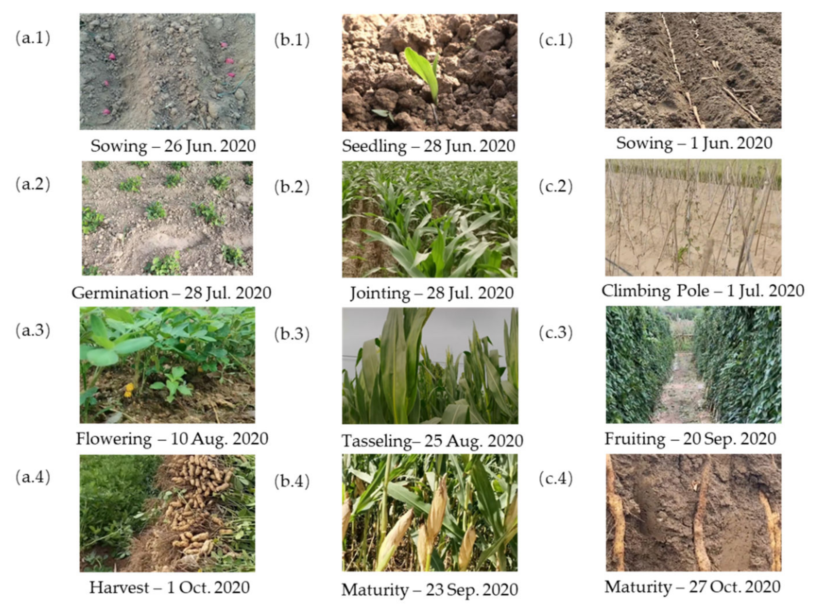
| Peanut | sowing | germination | flowering | pod setting | maturity | ||||||||||
| Maize | sowing | jointing | tasseling | maturity | |||||||||||
| Chinese yam | flowering | fruiting | maturity | ||||||||||||
| Category | Government Statistics Area (hm2) | Sample Label Area (hm2) | Ratio (%) |
|---|---|---|---|
| Maize | 17,281 | 85.24 | 0.49 |
| Chinese yam | 5228 | 20.71 | 0.40 |
| Peanut | 3497 | 15.53 | 0.44 |
| Others | 22,124 | 24.91 | 0.11 |
| Sequence | Category | No. of Parcels | No. of Pixels | ||
|---|---|---|---|---|---|
| Training Set | Testing Set | Training Set | Testing Set | ||
| 1 | Maize | 22 | 11 | 4867 | 5848 |
| 2 | Peanut | 19 | 9 | 1224 | 670 |
| 3 | Chinese yam | 13 | 6 | 1862 | 437 |
| 4 | Others | 250 | 305 | 1404 | 1714 |
| - | All | 304 | 331 | 9357 | 8669 |
| Data Category | Overall Accuracy (%) | Kappa Coefficient |
|---|---|---|
| 5 August 2020 Sentinel-2 | 81.3 | 0.814 |
| Multi-temporal Sentinel-1 | 73.4 | 0.732 |
| Multi-temporal Sentinel-2 | 87.6 | 0.861 |
| Fused multi-temporal Sentinel-1 and -2 | 90.5 | 0.881 |
| Truth Data | ||||||
|---|---|---|---|---|---|---|
| Maize | Peanut | Chinese Yam | Others | PA (%) | ||
| Maize | 5351 | 114 | 68 | 315 | 91.5 | |
| Classifier | Peanut | 22 | 571 | 54 | 23 | 85.2 |
| Results | Chinese yam | 8 | 30 | 387 | 12 | 88.6 |
| Others | 169 | 3 | 6 | 1536 | 89.6 | |
| UA (%) | 96.4 | 79.5 | 75.1 | 81.4 | ||
| OA = 90.5% | Kappa = 0.881 | |||||
| Category | Predicted Area (hm2) | Government Statistics Area (hm2) |
|---|---|---|
| Peanut | 3188 ± 335 | 3497 |
| Maize | 15,947 ± 1674 | 17,281 |
| Chinese yam | 4756 ± 499 | 5228 |
Publisher’s Note: MDPI stays neutral with regard to jurisdictional claims in published maps and institutional affiliations. |
© 2022 by the authors. Licensee MDPI, Basel, Switzerland. This article is an open access article distributed under the terms and conditions of the Creative Commons Attribution (CC BY) license (https://creativecommons.org/licenses/by/4.0/).
Share and Cite
Zhang, H.; Yuan, H.; Du, W.; Lyu, X. Crop Identification Based on Multi-Temporal Active and Passive Remote Sensing Images. ISPRS Int. J. Geo-Inf. 2022, 11, 388. https://doi.org/10.3390/ijgi11070388
Zhang H, Yuan H, Du W, Lyu X. Crop Identification Based on Multi-Temporal Active and Passive Remote Sensing Images. ISPRS International Journal of Geo-Information. 2022; 11(7):388. https://doi.org/10.3390/ijgi11070388
Chicago/Turabian StyleZhang, Hebing, Hongyi Yuan, Weibing Du, and Xiaoxuan Lyu. 2022. "Crop Identification Based on Multi-Temporal Active and Passive Remote Sensing Images" ISPRS International Journal of Geo-Information 11, no. 7: 388. https://doi.org/10.3390/ijgi11070388
APA StyleZhang, H., Yuan, H., Du, W., & Lyu, X. (2022). Crop Identification Based on Multi-Temporal Active and Passive Remote Sensing Images. ISPRS International Journal of Geo-Information, 11(7), 388. https://doi.org/10.3390/ijgi11070388