Abstract
The Amazon has a population that is largely urban. However, research is limited regarding representations and analysis of the urban Amazon. This article represents and describes Amazonian urban areas by applying a multicriteria urbanization index. Using the Ecuadorian Amazon as a case study, we constructed this index considering spatial indicators of fractal dimension, number of paved streets, urban luminosity, population density, and Euclidean distances from each urban patch to the closest deforested area, to the closest oil pollution point, and to the closest mining pollution point. The multicriteria urbanization index was classified in five classes (degrees) of urbanization: very low, low, medium, high, and very high levels of urbanization. Most of the urban areas have a low degree of urbanization; notwithstanding, there are areas with a medium degree of urbanization encompassing consolidated cities and suburbs, with a high potential for extension in the future. There are also areas of high and very high urbanization related to the oil industry, including cities which have a high impact on the territorial system of the Amazon. This investigation serves as an introduction to multidimensional spatial and quantitative analyses of the urban Amazon. We suggest monitoring the urban advance in the Amazon using the index developed in this investigation, to support better territorial planning in this region of the world having high strategical importance.
1. Introduction
The Amazon is a territory with high biodiversity, and is the home of diverse indigenous nationalities. However, this reality may mask the Amazonian urban phenomenon. Cities are crucial for driving drastic dynamics and changes in the Amazon. Urban configurations in the Amazon are atypical and even chaotic; nevertheless, Amazonian populations consider cities as opportunities for accessing services and as alternatives to traditional lifestyles [1]. Thus, urban expansion in the Amazon is not only interpreted as the growth of cities, but also as the expansion of urban society to rural landscapes, a transformation that defines the Amazon as the ‘urban forest’ [2]. In this context, the Amazon represents a territory where urban and rural areas intersect, defined by urban–rural mobilities and migrations, economic and market hybrid transformations, and microregional and land-use modifications [3,4,5,6,7]. In this sense, rural areas in the Amazon acquire the same theoretical status as the city [3]. Within this countryside, emerging urban and suburban areas are the ‘building blocks’ of the Amazon urban network/urban forest. Consequently, the urban Amazon can be seen as a polycentric, highly diverse, and multihierarchical phenomenon. This complexity and social–spatial heterogeneity configure new spatial structures to form urban areas in the Amazon [8]; these spatial structures need to be assessed and represented in well-defined spatial units in order to offer more transparency in the interpretation of the Amazonian urban phenomenon. The phenomenon of urbanization in the Amazon was consolidated by the capitalist market economy marked by the expansion of industries dedicated to extracting natural resources (e.g., mining, oil, timber) and by the implementation of extensive agricultural operations [9]. In this context, the urban Amazon is a consequence of planetary urbanization. In planetary urbanization, there is not an ‘outside’ of the urban world; rather, there is a planetary formation of capitalist urbanization based on environmental disturbances, the extraction of resources, and commodification of spaces [10].
The dynamics of natural resource extraction in the Amazon result in changes in land uses and land covers (e.g., deforestation), which led to the creation and development of urban areas [11]. The socio–spatial configurations of Amazonian urban areas show direct links between cities and the countryside [3]. Consequently, the urban Amazon should not only be represented by the consolidated Amazonian cities, but also by ‘proto-urban’ zones that represent the extended urbanization in this area of the world. Urbanization in the Amazon is highly related to the environmental impact on native ecosystems, caused by the mining and oil industries. Therefore, when assessing the expansion of urban areas in the Amazon, it is essential to consider issues such as deforestation and extractive economic activities [11,12].
Analysis of urban areas in the Amazon region can benefit from data extracted from nighttime satellite sensor imagery. This type of information has demonstrated a strong correlation with data derived from census-based urban population statistics and energy consumption [13,14]. It has also been employed for cluster analysis to establish typologies for urban regions within the Amazon [15]. In Latin America, the utilization of nighttime satellite imagery has proven valuable in identifying the influence of local landscapes and socioeconomic dynamics, such as housing prices and migration, on urban growth in the peripheries of cities [16]. The latter dynamic plays a significant role in driving urbanization within the Amazon region [3,4]. Artificial luminosity also shows a correlation with urban population [13,17]. However, nighttime imagery may have limitations when estimating population density [18]. Furthermore, in the case of the Amazon, there are human settlements with certain urban infrastructures that lack access to electricity, as well as urban areas with low population density but substantial luminosity due to the presence of the oil industry’s infrastructure. In the Amazon, population density can be linked to the development of urban centers and the implementation of infrastructure for natural resource extraction. Additionally, a higher density of rural populations and the presence of roads are key factors contributing to deforestation [19], and sometimes high population density can even be associated with lower levels of deforestation, indicating a phenomenon known as ‘discrete urbanization’ in rural Amazonian areas [20]. In summary, population density serves as a valuable indicator for understanding urban processes in the Amazon region, irrespective of indicators related to deforestation and artificial lighting.
One crucial aspect of landscape patterns involves the shape of land use and land cover patches. The analysis of these patch shapes often involves measures of fractality. Pioneering work by Batty and Longley [21] has demonstrated that urban shapes exhibit fractal properties that vary across scales and over time. Fractal growth theory posits that urban areas may exhibit tentacular shapes, resembling tree-like structures [22], implying dynamic processes of urban growth [23]. Typically, metrics used to calculate the fractality of urban areas rely on area and perimeter, and these metrics are scale-dependent [24]. Additionally, the presence of paved roads serves as a significant indicator of urbanization processes and dynamics [25]. Such dynamics encompass the formation of urban heat islands [26], energy consumption patterns [27], reduced vegetation cover [28], and the development of knowledge-based regional activities [29]. In the Amazon, the presence of roads, especially paved ones, serves as a crucial marker of deforestation, as well as urban consolidation and expansion [1,30,31]. The construction and paving of roads not only increase, but also facilitate the movement and mobility of people, a key factor contributing to urban expansion within the Amazon.
Traditionally, the Amazonian territory has been depicted using spatial visualizations that emphasize natural protected areas, forested and deforested regions, indigenous territories, and zones dedicated to oil and mining activities. These visualizations often obscure the presence of urban areas within the Amazon. It is essential to accurately represent and assess urbanization in the Amazon region to support sustainable planning for this vast territory. However, the urban Amazon has received limited attention in terms of representation and research. Furthermore, there is a significant scarcity of spatial and quantitative analyses related to this representation. The primary objective of this research is to quantify and characterize urbanization in the Amazon by developing a multicriteria urbanization index. This index will be constructed using several indicators that capture various aspects of the urbanization process within the Amazon.
2. Materials and Methods
The focus of this investigation is the Ecuadorian Amazon, covering an expansive territory of 120,000 square kilometers and inhabited by an estimated population of nearly 1 million people. Despite the relatively low population density in the Ecuadorian Amazon, which stands at around 8 individuals per square kilometer, the majority of its residents reside in urban areas. It is worth noting that, despite Ecuador’s portion being relatively small compared to the entire Amazon region, the size of the Ecuadorian Amazon is larger than that of entire countries, such as Iceland or Hungary. Figure 1 provides a visual representation of the Ecuadorian Amazon.
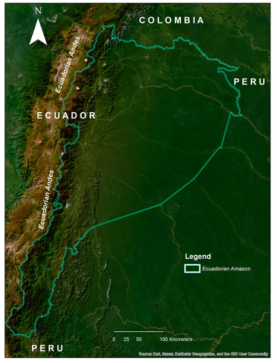
Figure 1.
Study area: the Amazon of Ecuador.
We utilized Google Earth Engine to extract urban land cover information obtained from MapBiomas (https://amazonia.mapbiomas.org/; accessed on 1 February 2023). The unit of analysis in this research comprises the urban land cover patches extracted from MapBiomas. MapBiomas generates this information by applying a random forest approach to process satellite imagery, encompassing not only Amazonian cities, but also urban patches of various sizes. For characterizing urban areas in the Amazon, we employed the following urban indicators: fractal dimension, the number of paved streets, urban luminosity, and Euclidean distance from each urban patch to the nearest deforested area, the closest oil pollution point, and the nearest mining pollution point. Fractal dimension represents the diversity and complexity of urban land use patches in the Amazon. Paved streets signify the advancement of the urbanization process in urban zones. It is important to note that Amazonian urban zones may include different types of streets, such as gravel paths, alongside paved streets. Urban luminosity captures the high variance in urban lighting within the Amazon, ranging from lights in small human settlements to those in cities with oil-related infrastructures. The Euclidean distances offer insights into the urban dynamics and impacts within the Amazon, a territory characterized by urban development closely tied to economies reliant on natural resource extraction. This comprehensive set of indicators has been demonstrated to effectively represent Amazonian urban regions [15]. Additionally, we incorporated an indicator of population density based on high-resolution population density data provided by Meta (https://dataforgood.facebook.com/dfg/tools/high-resolution-population-density-maps; accessed on 1 February 2023).
We calculated the fractal dimension for each of the urban patches, which served as the units of analysis, using the patch’s perimeter and area [15,32]. The assessment of urban luminosity was conducted using imagery provided by the National Oceanic and Atmospheric Administration (NOAA). For this purpose, we utilized the Google Earth Engine collection of VIIRS Nighttime Day/Night Band Composites Version 1, composed of the monthly average radiance data from the day–night band of the VIIRS radiometer series [33]. The radiance data were initially converted to W/m2, after which they were transformed into W/sr by multiplying the radiance value by the area of each pixel. These transformed values were then aggregated to correspond with each urban patch [34]. Table 1 summarizes the indicators used in composing the multicriteria urbanization index.

Table 1.
Indicators used to construct the multicriteria urbanization index.
The multicriteria urbanization index is computed through a weighted linear combination of the seven urban indicators explained previously. To identify potential multicollinearities among the indicators, variance inflation factors (VIFs) were calculated. The resulting VIF values indicated that all the indicators can be safely used in constructing the index. To normalize the indicators, we applied a min–max normalization method. To determine the weights assigned to each indicator, we employed the multicriteria analytical hierarchy process (AHP) [35]. AHP utilizes a 1 to 9 scale, known as the Saaty scale, for comparing indicators. In this scale, a value of 1 signifies that one indicator is equally important as another, while a value of 9 indicates that one indicator is extremely more important than the other. A critical aspect of AHP involves constructing a pairwise comparison matrix, which is populated with values corresponding to the Saaty scale, reflecting expert knowledge. A notable advantage of AHP is its ability to mathematically validate the consistency of various expert judgments. In this study, we consulted with 10 experts who specialize in Amazonian urban processes. These experts possess expertise in urban studies of the Amazon, urban analyses, urban planning, urban geography, and spatial analyses. The pairwise comparison matrix was normalized, and from this, the eigenvalue vector was calculated, representing the weights for each indicator. The resulting pairwise comparison matrix, along with the calculated indicator weights, is presented in Table 2.
Table 2.
Pairwise comparison matrix for the AHP.
To assess the consistency of expert judgments, we calculated the consistency ratio [36]:
is calculated using the following equation:
where represents the number of indicators and is the is the average of all the components of the vector obtained from the eigenvector and the pairwise comparison matrix.
The random index, , is defined by the number of indicators [37]. For seven indicators, equals to 1.32.
As mentioned previously, the multicriteria urbanization index is determined by a weighted linear combination of seven normalized urban indicators. Higher index values indicate a higher degree of urbanization. In the case of distance-based indicators in our study area, a greater proximity to environmental impacts corresponds to higher urbanization levels. Therefore, for the linear combination used to calculate the index, we consider the inverse of the distance-based indicators. To enhance the interpretability of the index, the final values are subjected to min–max normalization. Values closer to 0 represent lower urbanization levels, while values closer to 1 signify higher urbanization levels.
3. Results
We identified a total of 8049 urban areas (referred to as urban patches or units) in the Ecuadorian Amazon. In broad terms, the Ecuadorian Amazon exhibits a relatively low level of urbanization, with an average multicriteria urbanization index of 0.29 ± 0.03. However, upon closer examination, certain urban areas display notably high levels of urbanization, as we will explore shortly. Figure 2 illustrates the urban patches along with their respective multicriteria urbanization index values. The majority of urban patches in the Ecuadorian Amazon demonstrate lower levels of urbanization, with index values ranging from 0.21 to 0.40. Particularly in the northern Ecuadorian Amazon, these patches tend to cluster around areas with the highest levels of urbanization. Moreover, a number of these patches follow linear patterns, often coinciding with major roadways.
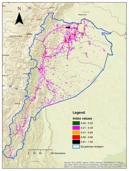
Figure 2.
Spatial visualization of the multicriteria urbanization index.
Table 3 presents a classification of various values of the multicriteria index, categorized using equal intervals. Each class represents a specific degree of urbanization. Most urban patches fall into the low degree of urbanization category, encompassing three urban typologies: suburban areas of consolidated cities, small towns, and small urban zones randomly distributed throughout the territory. Additionally, there are six urban patches characterized by a very low degree of urbanization, scattered within the forest and in proximity to areas with a low degree of urbanization. The high and very high degrees of urbanization are primarily attributed to cities situated in the oil-producing region of the Ecuadorian Amazon. This includes Lago Agrio, the most prominent oil-producing city in the Amazon, as well as three cities in the north that are functionally connected to Lago Agrio. The medium degree of urbanization category comprises consolidated cities, some of which serve as provincial capitals in the Amazon, suburbs of the three northern cities, and urban patches with irregular shapes, often following the trajectories of roads.
Table 3.
Multicriteria urbanization index and its associated descriptions.
It is important to mention that patches with the highest fractal dimension values correspond to areas with high and very high levels of urbanization. However, all urban patches within the study area exhibit a fractal dimension below 1.2. Fractal dimensions greater than 1 indicate shape complexity, with higher values signifying greater shape convolution (with a maximum value of 2) [32]. The results obtained reveal the presence of Amazonian urban zones characterized by noncompact shapes (unlike planned cities worldwide, which typically have compact shapes), but instead exhibit irregular yet not extreme shapes. Notably, patches with very low and low levels of urbanization tend to be located closer to areas of deforestation rather than oil and mining pollution points, suggesting that urbanization processes are emerging in response to deforestation activities.
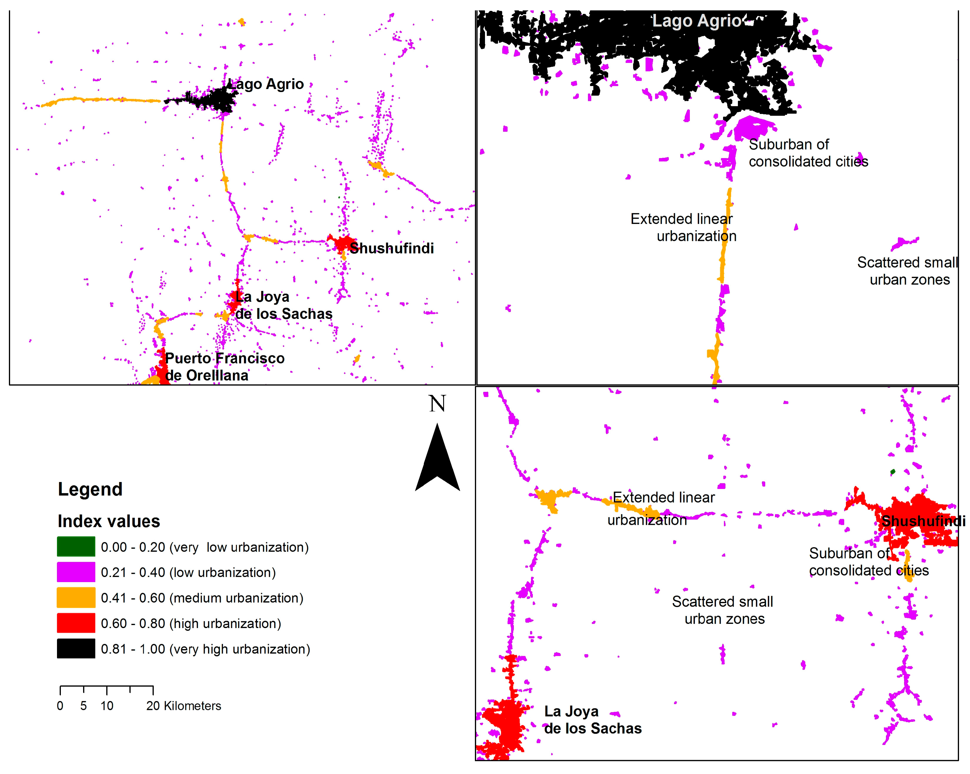
Lago Agrio, the urban patch with the highest degree of urbanization and luminosity, is the most distant urban area from mining pollution points. In contrast, urban patches with low and medium levels of urbanization are situated closer to mining pollution points. Generally, the northern Ecuadorian Amazon has undergone advanced urbanization primarily driven by the oil industry. This includes various degrees of urbanization, resulting in varying degrees of impact on native ecosystems.
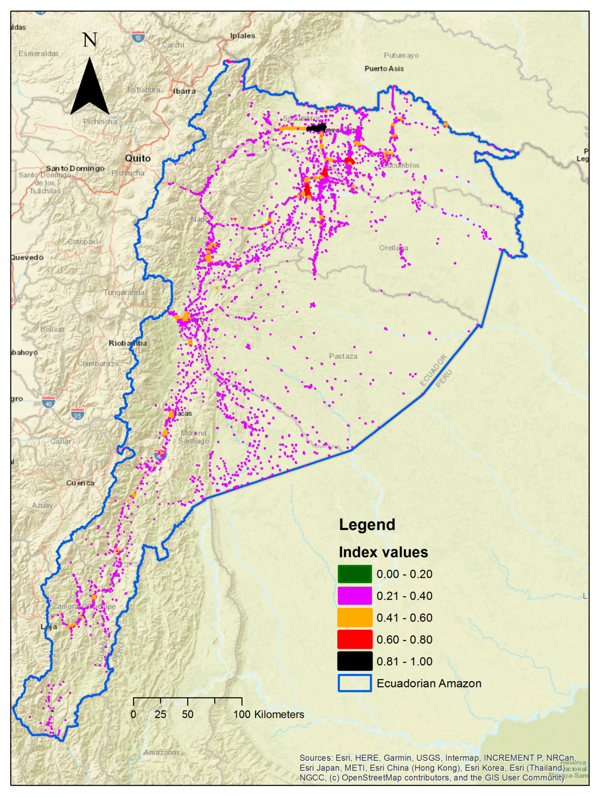
Figure 3 provides detailed examples of the multicriteria urbanization index. These examples encompass urban patches with the highest levels of urbanization, such as Lago Agrio city, along with the three northern Amazon cities: Shushufindi, Joya de los Sachas, and Puerto Francisco de Orellana. These cities, such as Lago Agrio, serve as urban centers closely associated with the oil industry. Additionally, these examples showcase various urban typologies, including suburbs of consolidated cities (with low and medium degrees of urbanization), extended linear urbanization (with a medium degree of urbanization), and scattered small urban zones (with a low degree of urbanization).

Figure 3.
Areas of the northern Amazon indicating index values, grades, or urbanization and typologies of urbanization.
4. Discussion
This research provides a unique perspective on urbanization in the Amazon region through the utilization of a multicriteria index composed of essential urban indicators and processes. It challenges the traditional, sometimes sentimental, perception of the Amazon solely as the ‘South American tropical forest’ by revealing the existence of well-defined urban areas inhabited by human populations. The urbanization in the Amazon, for the most part, can be characterized as residual urbanization, with varying interpretations among the diverse populations of the region [38]. Nonetheless, the spatial approach employed in this investigation objectively delineates areas that represent distinct degrees of urbanization, including well-established cities and emerging urban zones. We have identified six zones characterized by a very low degree of urbanization, which can be viewed as pivotal components of urban expansion within the Amazon. These zones encompass very small areas that are part of larger urban conurbations or scattered urban regions within the forest. This identified urban expansion reflects spaces influenced by state and capital-led resource extraction. In essence, resource extraction shapes a global urbanization process [39]. We consider the six identified emerging urban zones to be the initial ‘symptoms’ of planetary urbanization in specific forested regions. These are proto-urban forms, representing the initial stages of urban processes associated with the capitalist system in the Amazon [40].
Extractive activities in the Amazon result in distinct urban dynamics. For example, urban areas linked to the oil industry, such as Lago Agrio, the region with the highest level of urbanization in this study, encompass oil-related infrastructure with luminosity levels comparable to those of Ecuador’s largest cities, Quito and Guayaquil [41]. The three cities in the northern Amazon, namely Shushufindi, Joya de los Sachas, and Puerto Francisco de Orellana, characterized by high levels of urbanization, are also closely associated with the oil industry. The ‘urban presence’ of these cities extends into forested areas, primarily due to the luminosity generated by the oil industry. As a result, this expansion impacts rural systems and native rainforest ecosystems. It is essential to interpret urbanization in the Amazon within the context of territorial systems. Urban dynamics lead to diverse adaptations of the territory, extraction activities give rise to new housing projects, and periurban areas become arenas for the contestation of urbanization meanings and adaptations, particularly for Amazonian residents, including indigenous communities [38]. The territorial systems in the northern Ecuadorian Amazon have undergone significant transformation over the past 70 years, primarily due to the presence of the oil industry.
The majority of the areas examined in this study exhibit low levels of urbanization. These areas consist of scattered urban zones within the Amazonian territory, as well as zones surrounding established cities (suburban areas) and roads. We view these areas as a matrix that shapes urban expansion in the Amazon. Many urban areas in the Amazon have their roots in colonization, a spontaneous phenomenon often facilitated by the construction of roads, particularly those built by oil companies [3]. Additionally, there are urban areas that have developed in connection with state-promoted infrastructure [38]. In any case, the transformation of Amazonian land from rural to urban has relied on the growth of small communities along roads, and the emergence of suburbs around local towns [3]. The index generated in this research vividly illustrates these phenomena through the urban patches categorized as having low urbanization.
A significant number of urban areas exhibit a medium level of urbanization, including notable cities such as Puyo, Tena, Macas, and Loreto, some of which serve as provincial capitals in the Amazon. The urbanization of most of these cities can be primarily attributed to the intensification of agricultural activities, driven by their strategic location at the boundary between the Andes and the Amazon, characterized by highly productive volcanic soils [42]. The case of Puyo, the capital city of the Province of Pastaza, is unique. The city’s configuration and development are linked to agricultural activities and, notably, oil-related activities during the latter part of the last century. The medium level of urbanization also encompasses suburban areas of established cities and linear zones formed along roads. While peripheral in nature, these zones serve as the ‘building blocks’ of extended urbanization in the Amazon. We regard the 67 zones with a medium level of urbanization as an essential urban cluster. This cluster plays a crucial role in connecting rural areas, small towns, and medium-sized cities, serving as a precursor to more pronounced urbanization, akin to what has been observed in the northern part of the study area. It can also be seen as a subregional urban network that has the potential to shape new population distributions in the Amazon [43].
This research has some limitations. The first limitation pertains to the unit of analysis, which is the patches of urban land cover. In the Amazon, these units can vary significantly from one year to another, and may be subject to errors in satellite imagery classification. To address these issues, we recommend establishing an Amazonian urbanization observatory to calculate the urbanization index annually. Additionally, future research could explore alternative units of analysis, such as finer-scale urban land cover patches or census-based units. The second limitation relates to the use of spatial indicators in constructing the index, while urbanization can also be represented by social and economic indicators. In future research, we aim to calculate indices that represent urbanization in the Amazon by incorporating census-based indicators alongside spatial indicators. The distance-based indicators utilized in this study link environmental impacts with urbanization. In future studies, these indicators, along with others such as NDVI (normalized difference vegetation index), could be employed to evaluate the ecological conditions of the surrounding areas of urban zones.
To the best of our knowledge, this study represents the first attempt to investigate the urbanization phenomenon in the Amazon using spatial and quantitative approaches, employing a multicriteria index. Our research provides a fresh perspective on the Amazon, transcending the traditional views that predominantly focus on indigenous reserves, protected areas, and oil/mining blocks. This article can also be regarded as a pilot study for the quantitative assessment of Amazonian urbanization through multidimensional indices. Our index clearly delineates the nuances of the urbanization process in the Amazon.
These findings can inform territorial planning in the region, moving beyond the conventional city–countryside dichotomy, and fostering a deeper understanding that the Amazon is not only a territory for extraction, but also a space for urban living. The resulting index can be employed in regional-scale territorial planning, particularly to assist in land use planning, monitor urban expansion, and assess the impacts of proto-urban and suburban areas on both social and ecological aspects.
Our index acknowledges the intricate urban landscape of the Amazon, necessitating the implementation of multiple strategies to ensure a high quality of life for its residents. This includes urban planning schemes that integrate an urban network across the Amazon, models of compact urbanization to prevent extensive and residual urbanization, and concerted efforts to address social, economic, and environmental disparities, particularly in urban peripheries.
5. Conclusions
This investigation has unequivocally demonstrated that the Amazon is, indeed, an urban territory. It showcases a broad spectrum of urbanization levels within specific Amazonian regions. Urbanization in the Amazon takes the form of well-established cities, as well as scattered and fragmented suburban areas and proto-urban zones that mark the city’s frontier, and bridge the gap between rural and urban areas.
In the Ecuadorian Amazon, the northern region is characterized by cities associated with the oil industry, boasting very high and high levels of urbanization. These cities are interconnected by areas with medium and low levels of urbanization. In contrast, the central and southern regions feature urban areas with a medium level of urbanization, including cities, suburban regions, and linear urban patches. However, a significant proportion of urban areas fall into the category of low urbanization, indicating the presence of residual urbanization in the Amazon. Addressing this residual urbanization is crucial to minimize environmental impacts and develop Amazonian territories with a higher quality of urban life.
Author Contributions
Conceptualization, Pablo Cabrera-Barona and Gustavo Durán; methodology, Pablo Cabrera-Barona and Denise Albán; software, Denise Albán; validation, Pablo Cabrera-Barona and Gustavo Durán; formal analysis, Pablo Cabrera-Barona and Denise Albán; investigation, Pablo Cabrera-Barona; resources, Denise Albán; data curation, Denise Albán; writing—original draft preparation, Pablo Cabrera-Barona; writing—review and editing, Pablo Cabrera-Barona and Gustavo Durán; visualization, Denise Albán; supervision, Pablo Cabrera-Barona; project administration, Gustavo Durán; funding acquisition, Gustavo Durán. All authors have read and agreed to the published version of the manuscript.
Funding
This research and the APC were funded by the Facultad Latinoamericana de Ciencias Sociales Sede Ecuador (FLACSO Ecuador), “PDI de Fondo de Desarrollo Académico”, grant No. IP1138.
Data Availability Statement
Data are unavailable due to privacy restrictions.
Acknowledgments
The authors gratefully acknowledge the financial support provided by FLACSO Ecuador and the funding for the research stay to write a significant portion of this article at the Karlsruhe Institute of Technology (KIT). This latter funding was made possible through the European Union′s Horizon 2020 research and innovation program under the Marie Skłodowska-Curie grant agreement No. 873082, titled “CONTESTED_TERRITORY: From Contested Territories to Alternatives of Development: Learning from Latin America”. Furthermore, we would like to express our gratitude to the experts who contributed their knowledge to the calculation of the weights for the multicriteria urbanization index.
Conflicts of Interest
The authors declare no conflict of interest. The funders had no role in the design of this study; in the collection, analyses, or interpretation of data; in the writing of the manuscript; or in the decision to publish the results.
References
- Costa, S.M.; Brondízio, E.S. Cities Along the Floodplain of the Brazilian Amazon: Characteristics and Trends. In The Amazon Várzea: The Decade Past and the Decade Ahead; Pinedo-Vasquez, M., Ruffino, M.L., Padoch, C., Brondízio, E.S., Eds.; Springer: Dordrecht, The Netherlands, 2011; pp. 83–97. ISBN 978-94-007-0146-5. [Google Scholar]
- Becker, B. A Urbe Amazônida: A Floresta e a Cidade; Garamond: Rio de Janeiro, Brazil, 2013. [Google Scholar]
- Barbieri, A.F.; Monte-Mór, R.L.M.; Bilsborrow, R.E. Towns in the Jungle: Exploring Linkages between Rural-Urban Mobility, Urbanization and Development in the Amazon. In Urban Population-Envrionment Dyamics in the Developing World: Case Studies and Lessons Learned; Sherbiniin, A., Rahman, A., Barbieri, A., Fotso, J.C., Zhu, Y., Eds.; CICRED: Paris, France, 2009; pp. 247–279. ISBN 2-910053-35-0. [Google Scholar]
- Barbieri, A.F.; Carr, D.L. Gender-Specific out-Migration, Deforestation and Urbanization in the Ecuadorian Amazon. Glob. Planet. Change 2005, 47, 99–110. [Google Scholar] [CrossRef]
- Ryder, R.; Brown, L.A. Urban–System Evolution on the Frontier of the Ecuadorian Amazon. Geogr. Rev. 2000, 90, 511–535. [Google Scholar] [CrossRef]
- Trindade Junior, S.-C.C. Pensando a Modernização Do Território e a Urbanização Difusa Na Amazônia. Mercat. Rev. Geogr. UFC 2015, 14, 93–106. [Google Scholar] [CrossRef]
- Padoch, C.; Brondizio, E.; Costa, S.; Pinedo-Vasquez, M.; Sears, R.R.; Siqueira, A. Urban Forest and Rural Cities: Multi-Sited Households, Consumption Patterns, and Forest Resources in Amazonia. Ecol. Soc. 2008, 13. [Google Scholar] [CrossRef]
- Trindade Junior, S.-C.C. Uma Floresta Urbanizada? Legado e Desdobramentos de Uma Teoria Sobre o Significado Da Cidade e Do Urbano Na Amazônia. Espaço Aberto 2013, 3. [Google Scholar] [CrossRef]
- Browder, J.O.; Godfrey, B.J. Frontier Urbanization in the Brazilian Amazon: A Theoretical Framework for Urban Transition. Yearb. Conf. Lat. Am. Geogr. 1990, 16, 56–66. [Google Scholar]
- Brenner, N.; Schmid, C. Towards a New Epistemology of the Urban? City 2015, 19, 151–182. [Google Scholar] [CrossRef]
- Richards, P.; VanWey, L. Where Deforestation Leads to Urbanization: How Resource Extraction Is Leading to Urban Growth in the Brazilian Amazon. Ann. Assoc. Am. Geogr. 2015, 105, 806–823. [Google Scholar] [CrossRef]
- Bayón, M. Una Mirada de La Amazonía a Través de La Urbanización. In Geografía Crítica Para Detener el Despojo de los Territorios; Abya-Yala: Quito, Ecuador, 2019; pp. 191–205. ISBN 978-9942-09-643-2. [Google Scholar]
- Amaral, S.; Monteiro, A.M.V.; Camara, G.; Quintanilha, J.A. DMSP/OLS Night-time Light Imagery for Urban Population Estimates in the Brazilian Amazon. Int. J. Remote Sens. 2006, 27, 855–870. [Google Scholar] [CrossRef]
- Amaral, S.; Câmara, G.; Monteiro, A.M.V.; Quintanilha, J.A.; Elvidge, C.D. Estimating Population and Energy Consumption in Brazilian Amazonia Using DMSP Night-Time Satellite Data. Comput. Environ. Urban Syst. 2005, 29, 179–195. [Google Scholar] [CrossRef]
- Cabrera-Barona, P.F.; Bayón, M.; Durán, G.; Bonilla, A.; Mejía, V. Generating and Mapping Amazonian Urban Regions Using a Geospatial Approach. ISPRS Int. J. Geo-Inf. 2020, 9, 453. [Google Scholar] [CrossRef]
- Parés-Ramos, I.K.; Álvarez-Berríos, N.L.; Aide, T.M. Mapping Urbanization Dynamics in Major Cities of Colombia, Ecuador, Perú, and Bolivia Using Night-Time Satellite Imagery. Land 2013, 2, 37–59. [Google Scholar] [CrossRef]
- Sutton, P.; Roberts, D.; Elvidge, C.; Baugh, K. Census from Heaven: An Estimate of the Global Human Population Using Night-Time Satellite Imagery. Int. J. Remote Sens. 2001, 22, 3061–3076. [Google Scholar] [CrossRef]
- Anderson, S.J.; Tuttle, B.T.; Powell, R.L.; Sutton, P.C. Characterizing Relationships between Population Density and Nighttime Imagery for Denver, Colorado: Issues of Scale and Representation. Int. J. Remote Sens. 2010, 31, 5733–5746. [Google Scholar] [CrossRef]
- Laurance, W.F.; Albernaz, A.K.M.; Schroth, G.; Fearnside, P.M.; Bergen, S.; Venticinque, E.M.; Da Costa, C. Predictors of Deforestation in the Brazilian Amazon. J. Biogeogr. 2002, 29, 737–748. [Google Scholar] [CrossRef]
- Tritsch, I.; Le Tourneau, F.-M. Population Densities and Deforestation in the Brazilian Amazon: New Insights on the Current Human Settlement Patterns. Appl. Geogr. 2016, 76, 163–172. [Google Scholar] [CrossRef]
- Batty, M.; Longley, P.A. Urban Shapes as Fractals. Area 1987, 19, 215–221. [Google Scholar]
- Longley, P.A.; Batty, M.; Shepherd, J. The Size, Shape and Dimension of Urban Settlements. Trans. Inst. Br. Geogr. 1991, 16, 75–94. [Google Scholar] [CrossRef]
- Shen, G. Fractal Dimension and Fractal Growth of Urbanized Areas. Int. J. Geogr. Inf. Sci. 2002, 16, 419–437. [Google Scholar] [CrossRef]
- Chen, Y. Normalizing and Classifying Shape Indexes of Cities by Ideas from Fractals. Chaos Solitons Fractals 2022, 154, 111653. [Google Scholar] [CrossRef]
- Aliyu, A.; Amadu, L. Urbanization, Cities, and Health: The Challenges to Nigeria—A Review. Ann. Afr. Med. 2017, 16, 149. [Google Scholar] [CrossRef] [PubMed]
- Cui, L.; Shi, J. Urbanization and Its Environmental Effects in Shanghai, China. Urban Clim. 2012, 2, 1–15. [Google Scholar] [CrossRef]
- Yang, S.; Shi, L. Prediction of Long-Term Energy Consumption Trends under the New National Urbanization Plan in China. J. Clean. Prod. 2017, 166, 1144–1153. [Google Scholar] [CrossRef]
- Biggs, T.W.; Anderson, W.G.; Pombo, O.A. Concrete and Poverty, Vegetation and Wealth? A Counterexample from Remote Sensing of Socioeconomic Indicators on the U.S.–Mexico Border. Prof. Geogr. 2015, 67, 166–179. [Google Scholar] [CrossRef]
- Tripathi, S.; Kutsenko, E.; Boos, V. How Different Patterns of Urbanization Affect Regional Innovation? Evidence from Russia. Int. J. Urban Sci. 2022, 26, 213–243. [Google Scholar] [CrossRef]
- Kirby, K.R.; Laurance, W.F.; Albernaz, A.K.; Schroth, G.; Fearnside, P.M.; Bergen, S.; Venticinque, E.M.; da Costa, C. The Future of Deforestation in the Brazilian Amazon. Futures 2006, 38, 432–453. [Google Scholar] [CrossRef]
- Pokorny, B.; Pacheco, P.; de Jong, W.; Entenmann, S.K. Forest Frontiers out of Control: The Long-Term Effects of Discourses, Policies, and Markets on Conservation and Development of the Brazilian Amazon. Ambio 2021, 50, 2199–2223. [Google Scholar] [CrossRef] [PubMed]
- Fragstats Shape Metrics. Available online: https://info.undp.org/docs/pdc/Documents/ECU/MetricasFragstats-English.pdf (accessed on 16 February 2023).
- Elvidge, C.D.; Baugh, K.; Zhizhin, M.; Hsu, F.C.; Ghosh, T. VIIRS Night-Time Lights. Int. J. Remote Sens. 2017, 38, 5860–5879. [Google Scholar] [CrossRef]
- Mejía, V. Procesos de Urbanización y Morfología Urbana En Ecuador: La Evolución de Los Usos Del Suelo a La Luz de La Imagen Satelital Nocturna de La Tierra 1992–2019; Universitat Autònoma de Barcelona: Barcelona, Spain, 2020. [Google Scholar]
- Saaty, T.L. A Scaling Method for Priorities in Hierarchical Structures. J. Math. Psychol. 1977, 15, 234–281. [Google Scholar] [CrossRef]
- Saaty, R. The Analytic Hierarchy Process-What It Is and How It Is Used. Math. Model. 1987, 9, 161–176. [Google Scholar] [CrossRef]
- Cabrera-Barona, P.; Murphy, T.; Kienberger, S.; Blaschke, T. A Multi-Criteria Spatial Deprivation Index to Support Health Inequality Analyses. Int. J. Health Geogr. 2015, 14. [Google Scholar] [CrossRef] [PubMed]
- Bayón Jiménez, M.; Durán, G. Decolonizar Los Estudios Urbanos Desde La Amazonía: Prácticas Indígenas Para Disputar La Urbanización Planetaria. Rev. INVI 2023, 38, 13–48. [Google Scholar] [CrossRef]
- Arboleda, M. Spaces of Extraction, Metropolitan Explosions: Planetary Urbanization and the Commodity Boom in Latin America. Int. J. Urban Reg. Res. 2016, 40, 96–112. [Google Scholar] [CrossRef]
- Brenner, N. Implosions/Explosions: Towards a Study of Planetary Urbanization; Jovis Verlag GmbH: Berlin, Germany, 2014; ISBN 9783868593174. [Google Scholar]
- Mejía, V.; Checa Rius, J. El Auge de La Urbanización Planetaria: Del Mediterráneo Ibérico a La Amazonía Ecuatoriana. Doc. d’Anàlisi Geogràfica 2022, 68, 563–579. [Google Scholar] [CrossRef]
- Jarrín Valladares, P.S.; Tapia Carrillo, L.; Zamora, G. La Colonia Interna Vigente: Transformación Del Territorio Humano En La Región Amazónica Del Ecuador. Let. Verdes. Rev. Latinoam. Estud. Socioambientales 2016, 20, 22–43. [Google Scholar] [CrossRef]
- Guedes, G.; Costa, S.; Brondízio, E. Revisiting the Hierarchy of Urban Areas in the Brazilian Amazon: A Multilevel Approach. Popul. Environ. 2009, 30, 159–192. [Google Scholar] [CrossRef] [PubMed]

Disclaimer/Publisher’s Note: The statements, opinions and data contained in all publications are solely those of the individual author(s) and contributor(s) and not of MDPI and/or the editor(s). MDPI and/or the editor(s) disclaim responsibility for any injury to people or property resulting from any ideas, methods, instructions or products referred to in the content. |
© 2023 by the authors. Licensee MDPI, Basel, Switzerland. This article is an open access article distributed under the terms and conditions of the Creative Commons Attribution (CC BY) license (https://creativecommons.org/licenses/by/4.0/).