Consistent Roof Geometry Encoding for 3D Building Model Retrieval Using Airborne LiDAR Point Clouds

Abstract
:1. Introduction
2. Methodology
2.1. System Overview
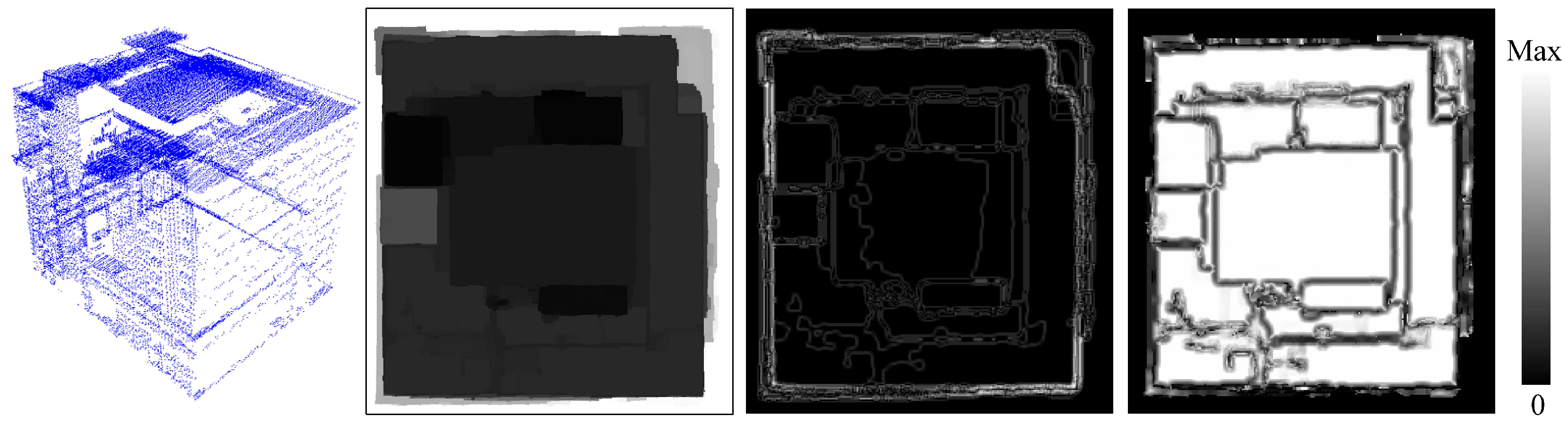
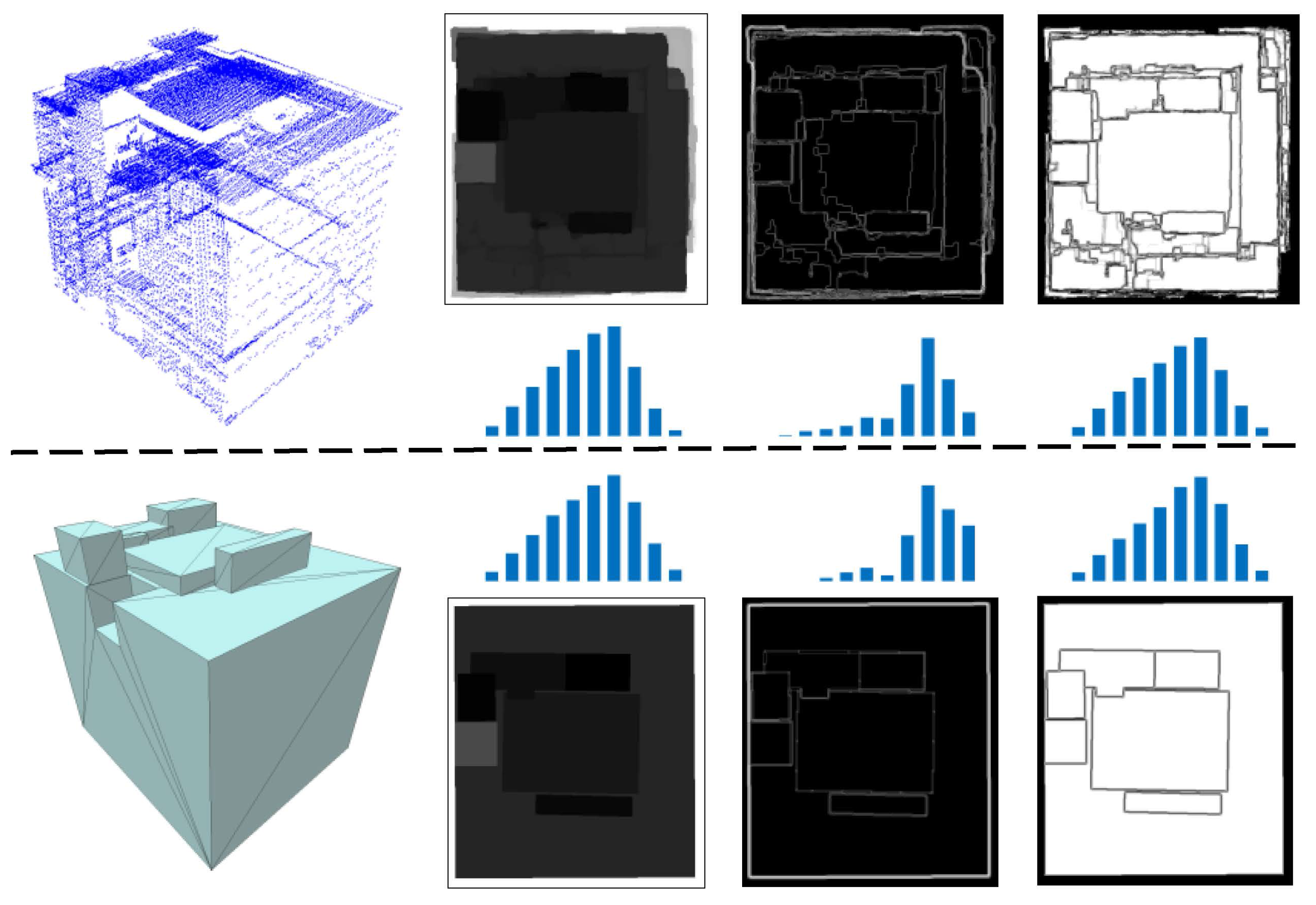
2.2. Generation of Depth Image
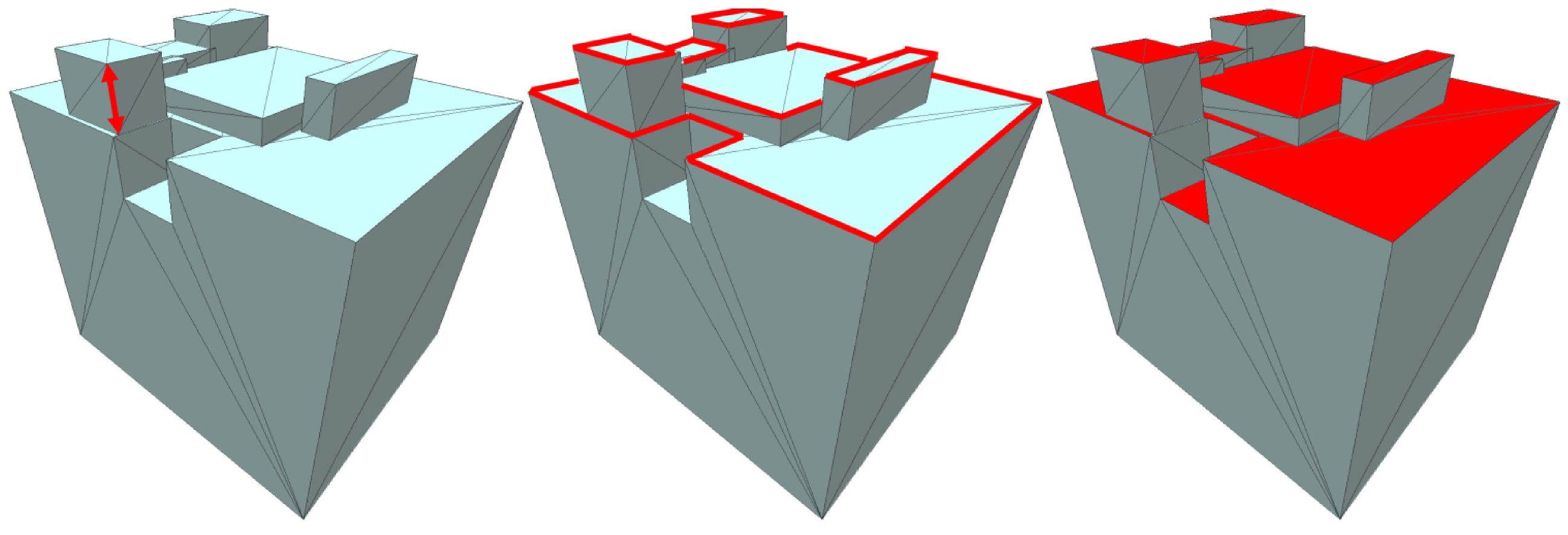
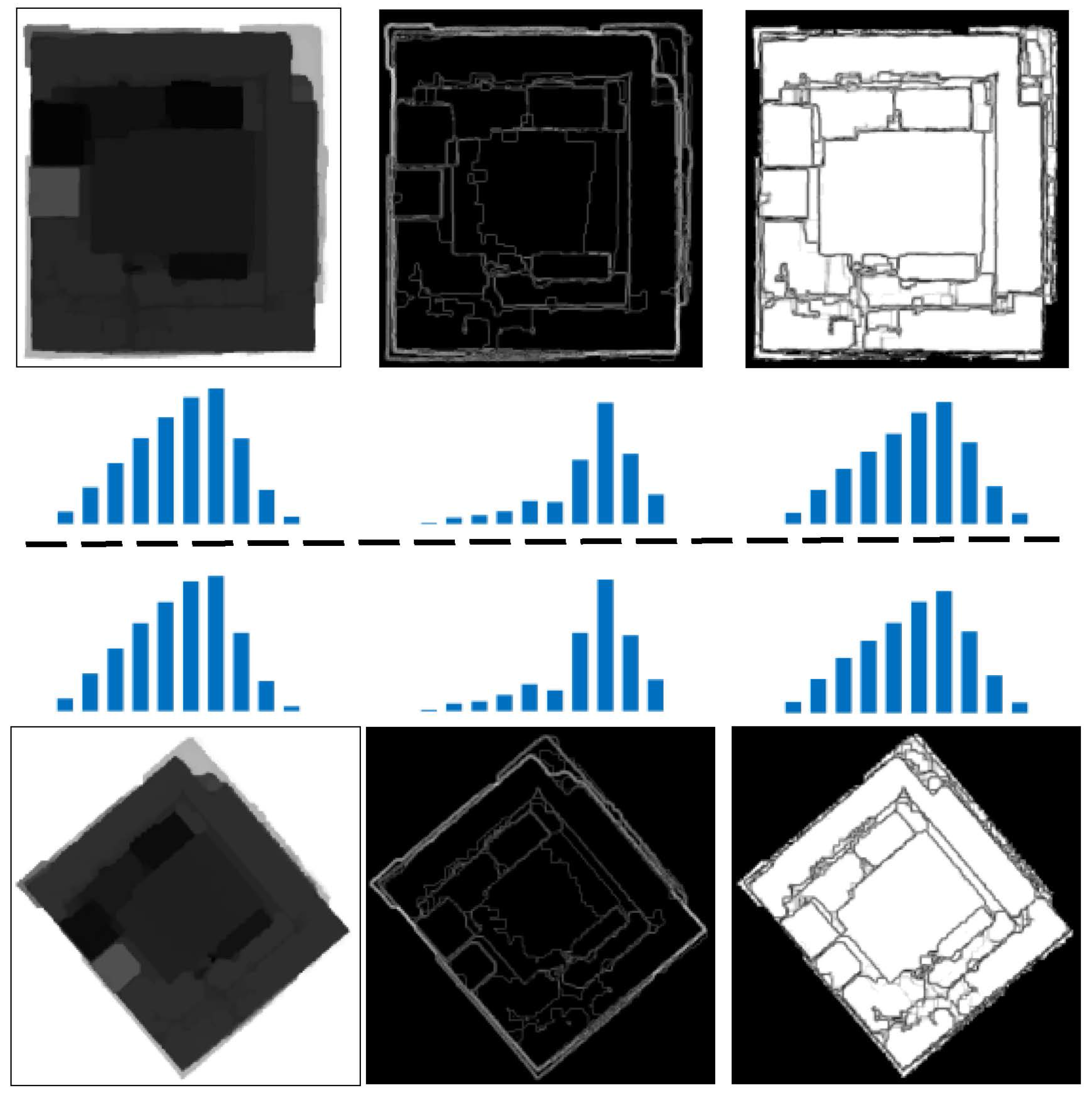
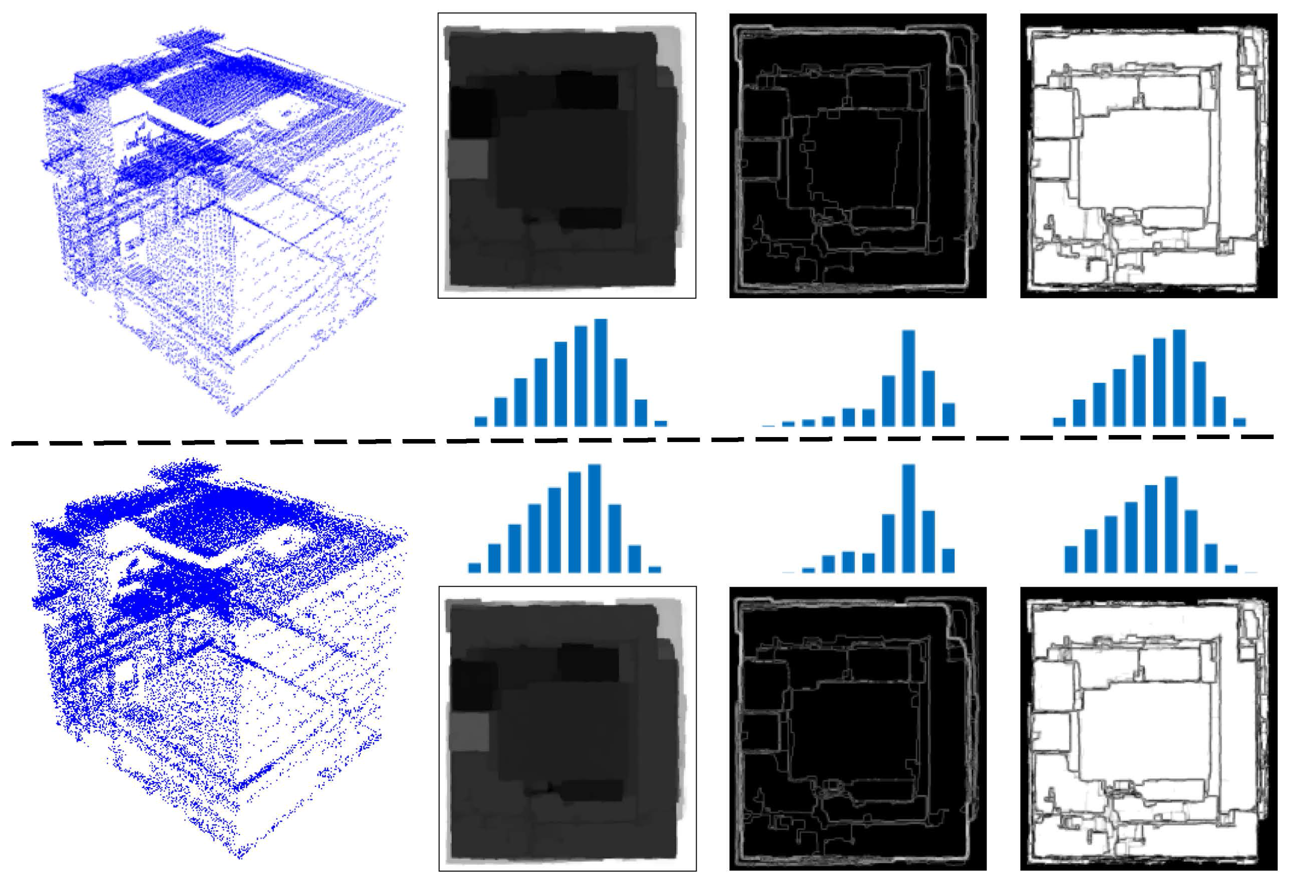
2.3. Data Encoding
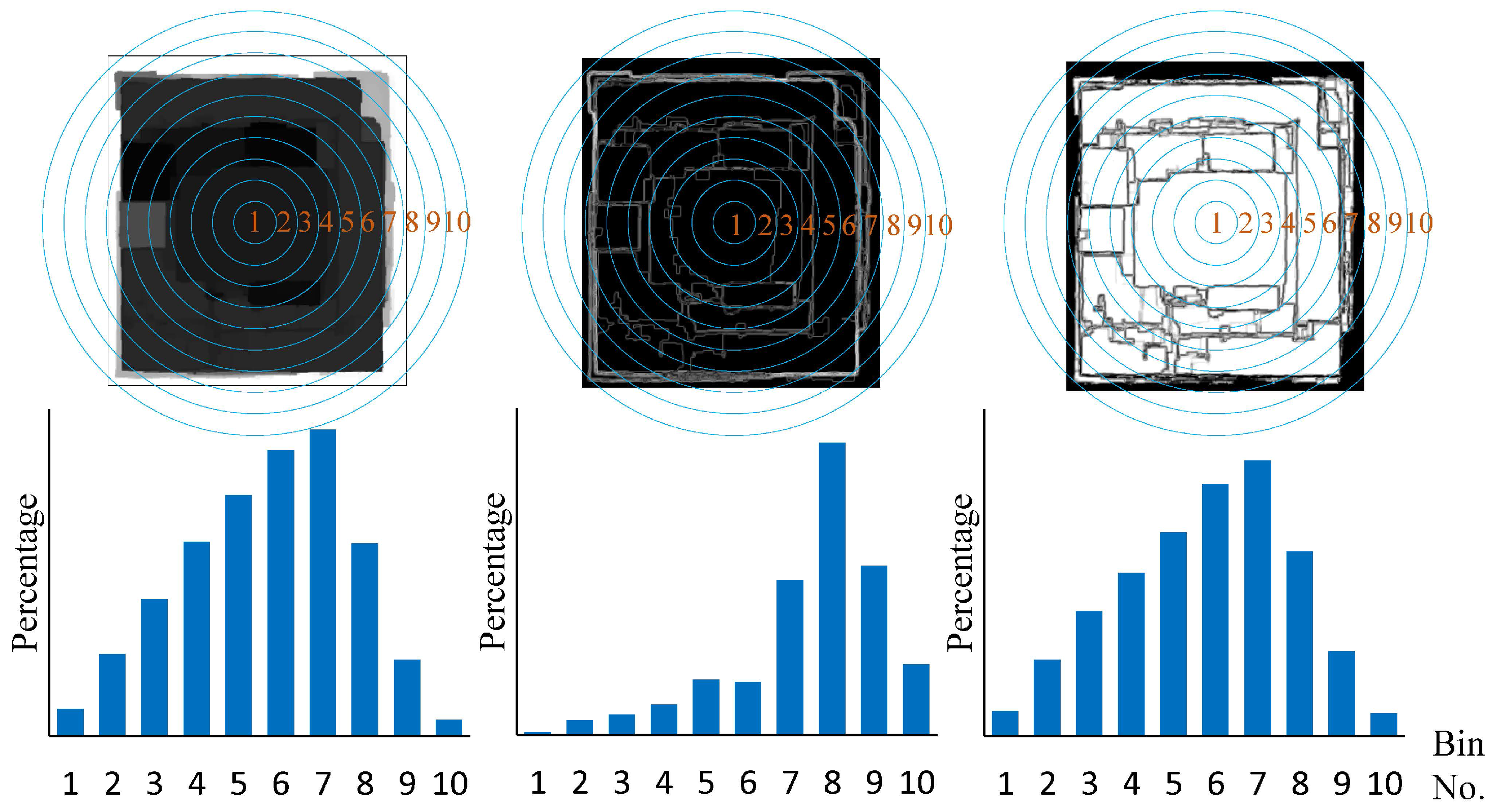
2.4. Spatial Histogram
2.5. Data Retrieval
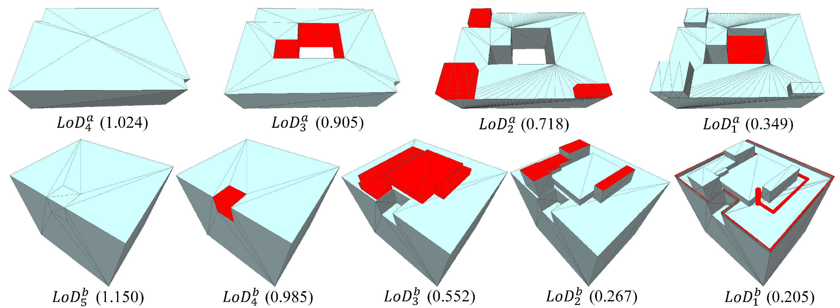
3. Encoding Properties
4. Experimental Results and Discussion
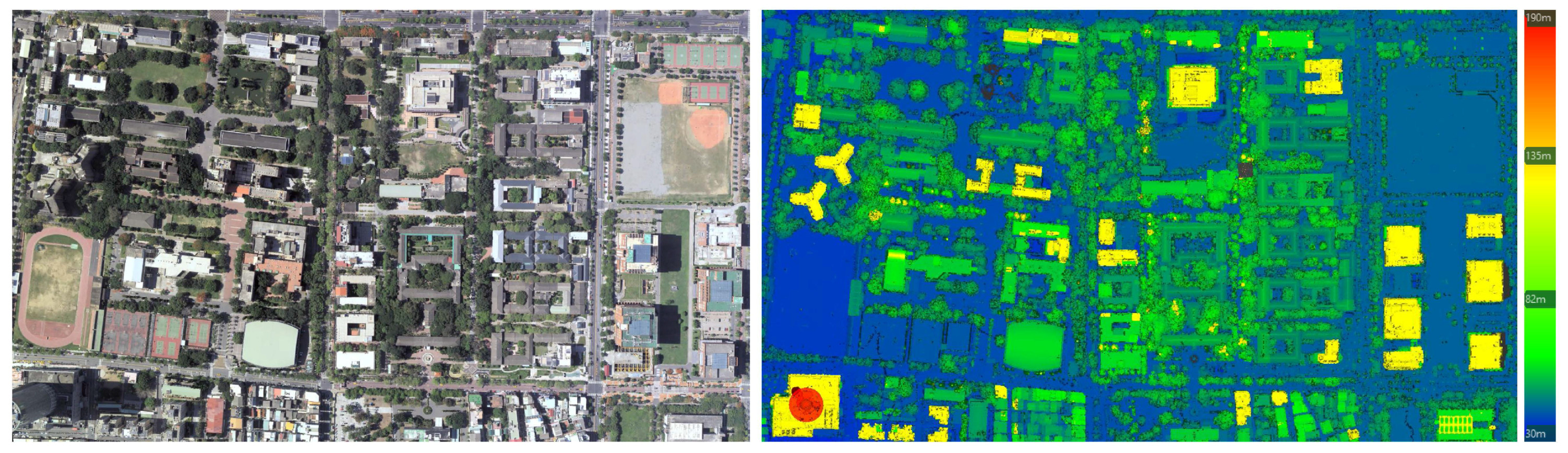
4.1. Datasets
4.2. Computational Performance
4.3. Evaluation of Model Encoding
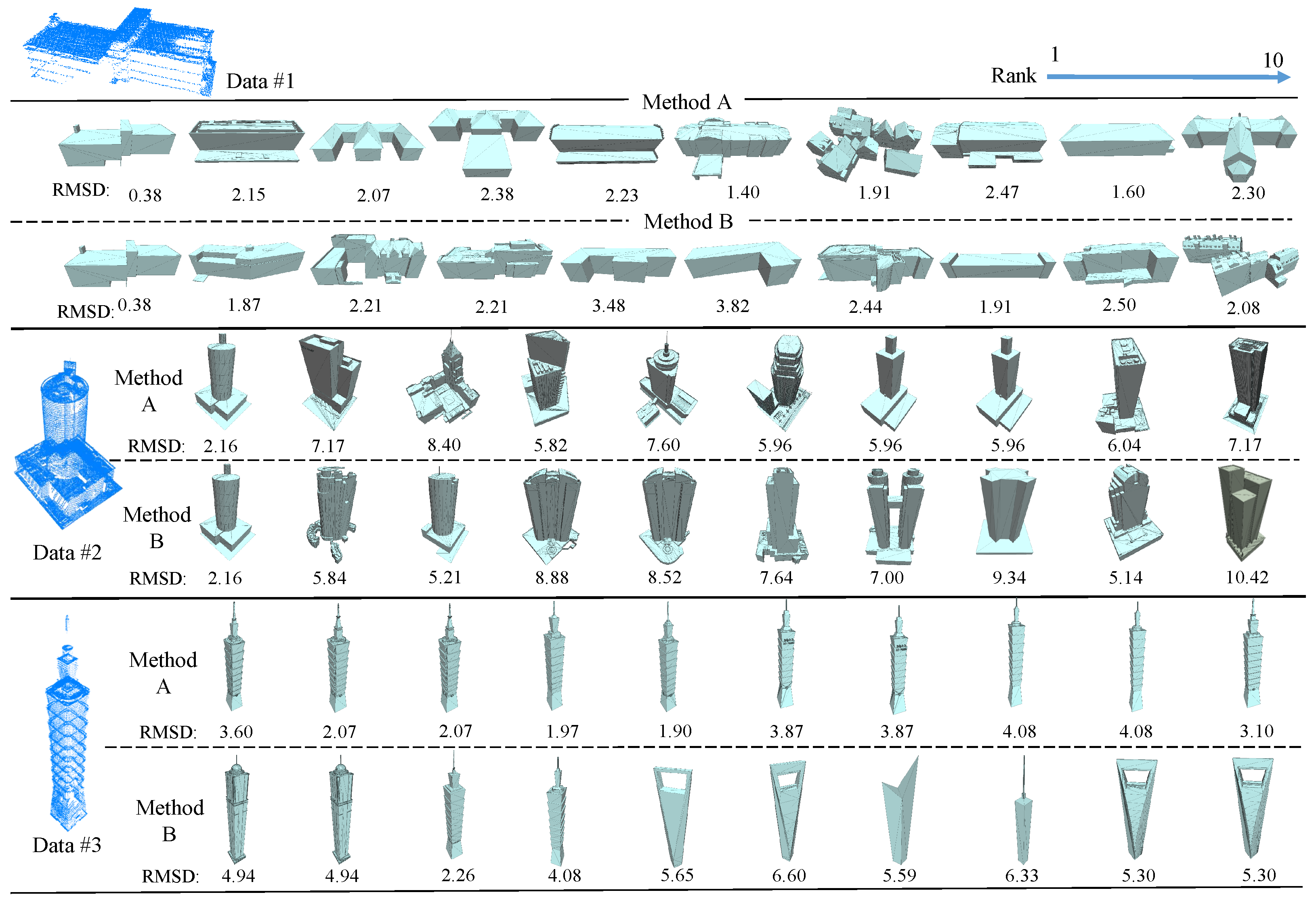
4.4. Evaluation of Model Retrieval
5. Conclusions and Future Work
Acknowledgments
Author Contributions
Conflicts of Interest
References
- Funkhouser, T.; Min, P.; Kazhdan, M.; Chen, J.; Halderman, A.; Dobkin, D.; Jacobs, D. A search engine for models. ACM Trans. Graph. 2003, 22, 83–105. [Google Scholar] [CrossRef]
- Huang, H.; Brenner, C.; Sester, M. A generative statistical approach to automatic 3d building roof reconstruction from laser scanning data. ISPRS J. Photogramm. Remote Sens. 2013, 79, 29–43. [Google Scholar] [CrossRef]
- Jarzgbek-Rychard, M.; Borkowski, A. 3D building reconstruction from ALS data using unambiguous decomposition into elementary structures. ISPRS J. Photogramm. Remote Sens. 2016, 118, 1–12. [Google Scholar] [CrossRef]
- Perera, G.S.N.; Maas, H.-G. Cycle graph analysis for 3D roof structure modelling: concepts and performance. ISPRS J. Photogramm. Remote Sens. 2014, 93, 213–216. [Google Scholar] [CrossRef]
- Xiong, B.; Elberink, S.O.; Vosselman, G. A graph edit dictionary for correcting errors in roof topology graphs reconstructed from point clouds. ISPRS J. Photogramm. Remote Sens. 2014, 93, 227–242. [Google Scholar] [CrossRef]
- Akgul, C.B.; Sankur, B.; Yemez, Y.; Schmitt, F. 3D model retrieval using probability density-based shape descriptors. IEEE Trans. Pattern Anal. Mach. Intell. 2009, 31, 1117–1133. [Google Scholar] [CrossRef] [PubMed]
- Gao, Y.; Wang, M.; Zha, Z.-J.; Tian, Q.; Dai, Q.-H.; Zhang, N.-Y. Less is more: efficient 3D object retrieval with query view selection. IEEE Trans. Multimedia 2011, 13, 1007–1018. [Google Scholar] [CrossRef]
- Mademlis, A.; Daras, P.; Tzovaras, D.; Strintzis, M.G. Ellipsoidal harmonics for 3-D shape description and retrieval. IEEE Trans. Multimedia 2009, 11, 1422–1433. [Google Scholar] [CrossRef]
- Tam, K.L.; Lau, W.H. Deformable model retrieval based on topological and geometric signatures. IEEE Trans. Vis. Comput. Graph. 2007, 13, 470–482. [Google Scholar] [CrossRef] [PubMed] [Green Version]
- Chen, D.Y.; Tian, X.P.; Shen, Y.T. On visual similarity based 3D model retrieval. Comput. Graph. Forum 2003, 22, 223–232. [Google Scholar] [CrossRef]
- Papadakis, P.; Pratikakis, I.; Perantonis, S.; Theoharis, T. Efficient 3D shape matching and retrieval using a concrete radialized spherical projection representation. Pattern Recognit. 2007, 40, 2437–2452. [Google Scholar] [CrossRef]
- Chen, J.-Y.; Lin, C.-H.; Hsu, P.-C.; Chen, C.-H. Point cloud encoding for 3D building model retrieval. IEEE Trans. Multimedia 2014, 16, 337–345. [Google Scholar] [CrossRef]
- Mohammad, A.; Zhang, C.; Fraser, C.S. Building Detection in Complex Scenes Thorough Effective Separation of Buildings from Trees. Photogramm. Eng. Remote Sens. 2012, 78, 729–745. [Google Scholar]
- Mallet, C.; Bretar, F.; Roux, M.; Soergel, U.; Heipke, C. Relevance assessment of full-waveform lidar data for urban area classification. ISPRS J. Photogramm. Remote Sens. 2011, 66, s71–s84. [Google Scholar] [CrossRef]
- Maltezos, E.; Ioannidis, C. Automatic Detection of Building Points from LIDAR and Dense Image Matching Point Clouds. ISPRS Ann. Photogramm. Remote Sens. Spat. Inf. Sci. 2015, II-3/W5, 33–40. [Google Scholar] [CrossRef]
- Gross, H.; Thoennessen, U. Extraction of lines from laser point clouds. Int. Arch. Photogramm. Remote Sens. Spatial Inf. Sci. 2016, 36, 86–91. [Google Scholar]
- Lin, C.-H.; Chen, J.-Y.; Su, P.-L.; Chen, C.-H. Eigen-feature analysis of weighted covariance matrices for LiDAR point cloud classification. ISPRS J. Photogramm. Remote Sens. 2014, 94, 70–79. [Google Scholar] [CrossRef]
- Li, Y.; Hu, Q.; Wu, M.; Liu, J.; Wu, X. Extraction and Simplification of Building Facade Pieces from Mobile Laser Scanner Point Clouds for 3D Street View Services. ISPRS Int. J. Geoinf. 2016, 5, 231. [Google Scholar] [CrossRef]
- Serna, A.; Marcotegui, B.; Hernandez, J. Segmentation of Facades from Urban 3D Point Clouds Using Geometrical and Morphological Attribute-Based Operators. ISPRS Int. J. Geoinf. 2016, 5, 6. [Google Scholar] [CrossRef]
- Mongus, D.; Lukač, N.; Žalik, B. Ground and building extraction from LiDAR data based on differential morphological profiles and locally fitted surfaces. ISPRS J. Photogramm. Remote Sens. 2014, 93, 145–156. [Google Scholar] [CrossRef]
- Besl, P.J.; McKay, N.D. Method for registration of 3D shapes. IEEE Trans. Pattern Anal. Mach. Intell. 1992, 14, 239–256. [Google Scholar] [CrossRef]


| Point Clouds | #Points | Area (m^2) | Avg.PD | GS (m) | Time Performance | |
|---|---|---|---|---|---|---|
| T_en(ms) T_re(ms) | ||||||
 | 50843 | 3050.1 | 16.67 | 0.245 | 155 | 606 |
 | 183719 | 9848.6 | 18.65 | 0.232 | 413 | 597 |
 | 26077 | 2141.750 | 12.18 | 0.287 | 155 | 579 |
 | 55061 | 3829.500 | 14.38 | 0.264 | 205 | 637 |
 | 29698 | 1342.438 | 22.12 | 0.212 | 155 | 606 |
| The Proposed Method/ Chen et al. (2014) | |||||||||
|---|---|---|---|---|---|---|---|---|---|
| Data #1 | Data #2 | Data #3 | |||||||
| Rank | RMSD | Ref. | Diffr | RMSD | Ref. | Diffr | RMSD | Ref. | Diffr |
| 1 | 0.38/0.38 | 1/1 | 0/0 | 2.16/2.16 | 1/1 | 0/0 | 3.60/4.95 | 7/13 | 6/12 |
| 2 | 2.15/1.87 | 9/4 | 7/2 | 7.18/5.84 | 12/5 | 10/3 | 2.07/4.95 | 3/12 | 110 |
| 3 | 2.07/2.21 | 7/10 | 4/7 | 8.40/5.21 | 15/3 | 12/0 | 2.07/2.26 | 3/5 | 0/2 |
| 4 | 2.38/2.21 | 14/11 | 10/7 | 5.83/8.88 | 4/17 | 0/13 | 1.97/4.08 | 2/10 | 2/6 |
| 5 | 2.23/3.48 | 12/18 | 7/13 | 7.60/8.52 | 13/16 | 8/11 | 1.90/5.65 | 1/17 | 4/12 |
| 6 | 1.40/3.82 | 2/19 | 4/13 | 5.96/7.64 | 6/14 | 0/8 | 3.87/6.60 | 9/19 | 3/13 |
| 7 | 1.91/2.44 | 6/15 | 1/8 | 5.96/7.00 | 7/10 | 0/3 | 3.87/5.59 | 8/16 | 1/9 |
| 8 | 2.47/1.91 | 16/5 | 8/3 | 5.96/9.34 | 7/18 | 1/10 | 4.08/6.33 | 10/18 | 2/10 |
| 9 | 1.59/2.50 | 3/17 | 6/8 | 6.04/5.14 | 9/2 | 0/7 | 4.08/5.30 | 10/14 | 1/5 |
| 10 | 2.30/2.08 | 13/8 | 3/2 | 7.17/10.42 | 11/19 | 1/9 | 3.10/5.30 | 6/14 | 4/5 |
| Avg.Diffr | 1.89/2.30 | 6.23/7.01 | 3.06/5.10 | ||||||
| # of queries | 1 | 2 | 3 | 4 | 5 | 6 | 7 | 8 | 9 | 10 | 11 | 12 | 13 | 14 | |
| MethodA | Precision | 0.00 | 0.00 | 0.33 | 0.50 | 0.40 | 0.33 | 0.29 | 0.25 | 0.22 | 0.20 | 0.18 | 0.25 | 0.23 | 0.21 |
| Recall | 0.00 | 0.00 | 0.07 | 0.14 | 0.14 | 0.14 | 0.14 | 0.14 | 0.14 | 0.14 | 0.14 | 0.21 | 0.21 | 0.21 | |
| MethodB | Precision | 1.00 | 1.00 | 1.00 | 1.00 | 1.00 | 1.00 | 1.00 | 1.00 | 1.00 | 1.00 | 1.00 | 1.00 | 1.00 | 0.93 |
| Recall | 0.07 | 0.14 | 0.21 | 0.29 | 0.36 | 0.43 | 0.50 | 0.57 | 0.64 | 0.71 | 0.79 | 0.86 | 0.93 | 0.93 |
© 2017 by the authors. Licensee MDPI, Basel, Switzerland. This article is an open access article distributed under the terms and conditions of the Creative Commons Attribution (CC BY) license (http://creativecommons.org/licenses/by/4.0/).
Share and Cite
Chen, Y.-C.; Lin, B.-Y.; Lin, C.-H. Consistent Roof Geometry Encoding for 3D Building Model Retrieval Using Airborne LiDAR Point Clouds. ISPRS Int. J. Geo-Inf. 2017, 6, 269. https://doi.org/10.3390/ijgi6090269
Chen Y-C, Lin B-Y, Lin C-H. Consistent Roof Geometry Encoding for 3D Building Model Retrieval Using Airborne LiDAR Point Clouds. ISPRS International Journal of Geo-Information. 2017; 6(9):269. https://doi.org/10.3390/ijgi6090269
Chicago/Turabian StyleChen, Yi-Chen, Bo-Yi Lin, and Chao-Hung Lin. 2017. "Consistent Roof Geometry Encoding for 3D Building Model Retrieval Using Airborne LiDAR Point Clouds" ISPRS International Journal of Geo-Information 6, no. 9: 269. https://doi.org/10.3390/ijgi6090269
APA StyleChen, Y.-C., Lin, B.-Y., & Lin, C.-H. (2017). Consistent Roof Geometry Encoding for 3D Building Model Retrieval Using Airborne LiDAR Point Clouds. ISPRS International Journal of Geo-Information, 6(9), 269. https://doi.org/10.3390/ijgi6090269