Multi-Criteria Decision Making (MCDM) Model for Seismic Vulnerability Assessment (SVA) of Urban Residential Buildings
Abstract
:1. Introduction
2. Materials and Methods
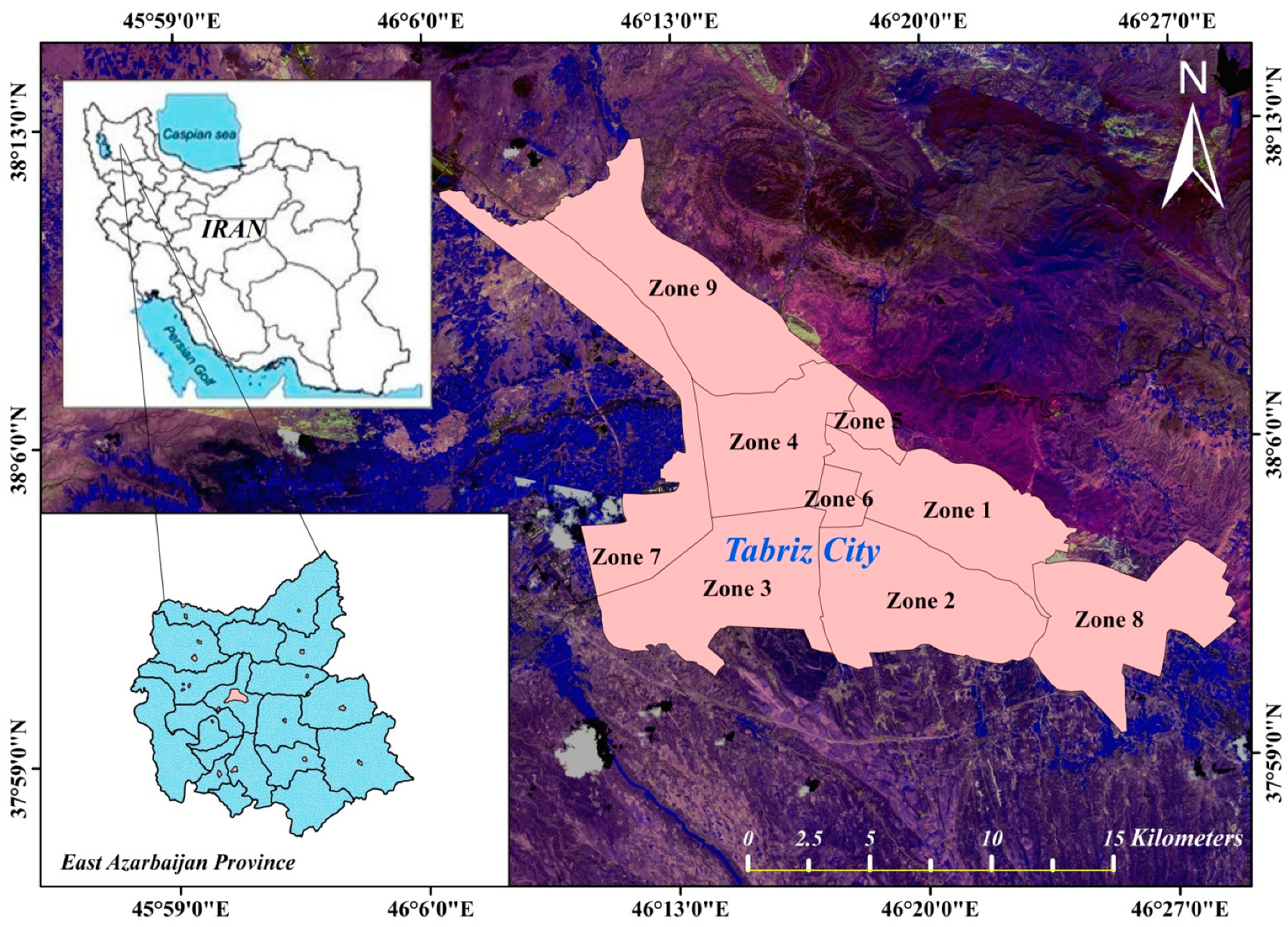
2.1. Geological and Seismic Characteristics of the Case Study
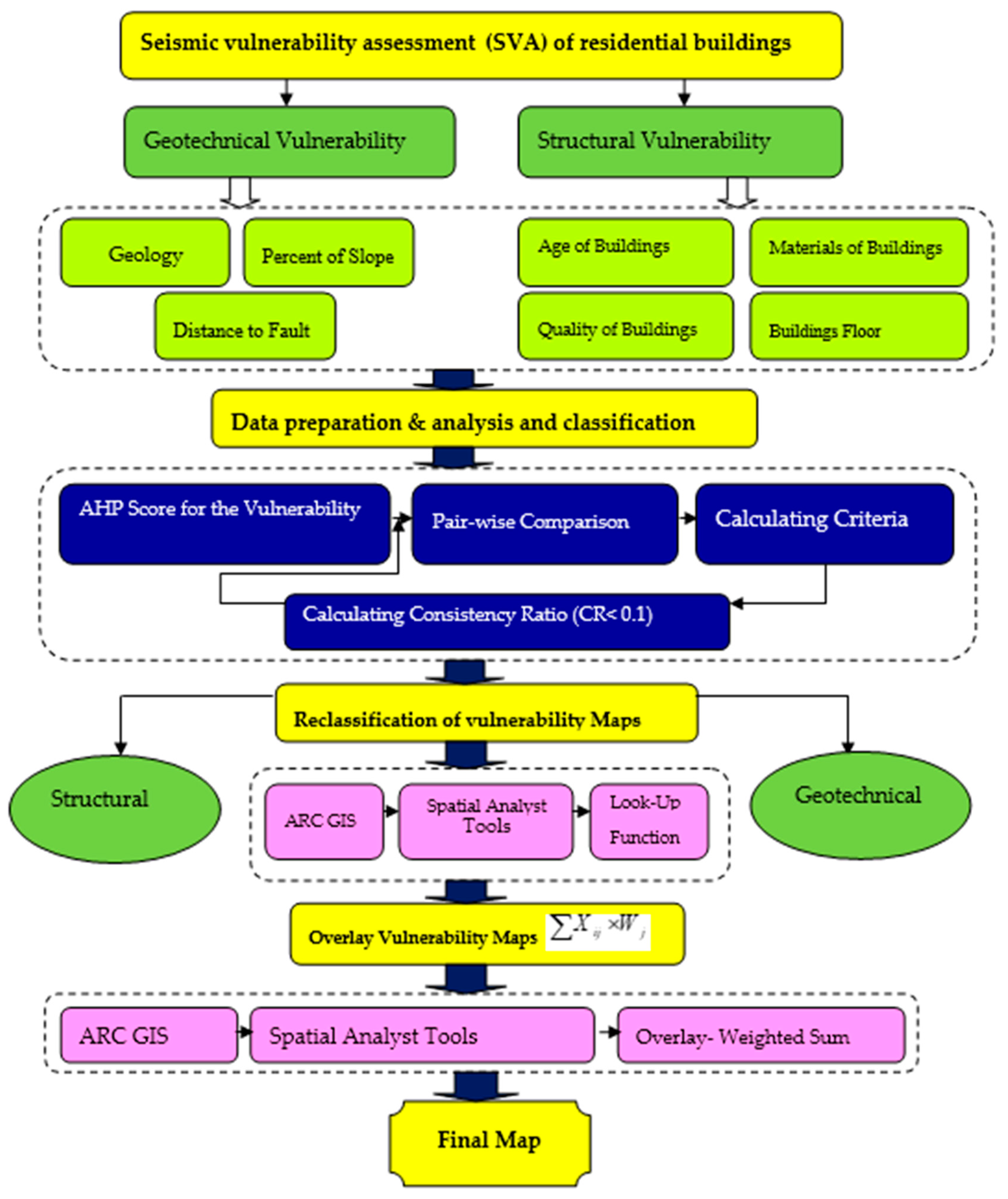
2.2. Analytic Hierarchy Process (AHP) Model
- Calculating the criteria scores. Each alternative is compared pairwise with respect to a specific criterion to obtain the scores () of alternatives. The eigenvectors are obtained after normalising the judgmental matrices.
- Calculating the criteria weights. Saaty (2008) [54] used the lambda max technique to obtain criteria weights by applying the pair-wise comparison method. Alternatives are compared pairwise with respect to each criterion to obtain weights (). Every matrix has a set of eigenvalues and for every eigenvalue, there is a corresponding eigenvector. In Saaty’s lambda max technique, a vector of weights is defined as the normalised eigenvector corresponding to the largest eigenvalue .
- Local priorities and consistency of comparisons. Once the judgmental matrix of comparisons of criteria with respect to the goal has been evaluated, the local priorities of criteria are obtained and the consistency of the judgments is determined. The scale of the pairwise comparison was introduced by Saaty (Table 1). It has been generally agreed that priorities of criteria can be estimated by finding the principal eigenvector w of the matrix A. That is:
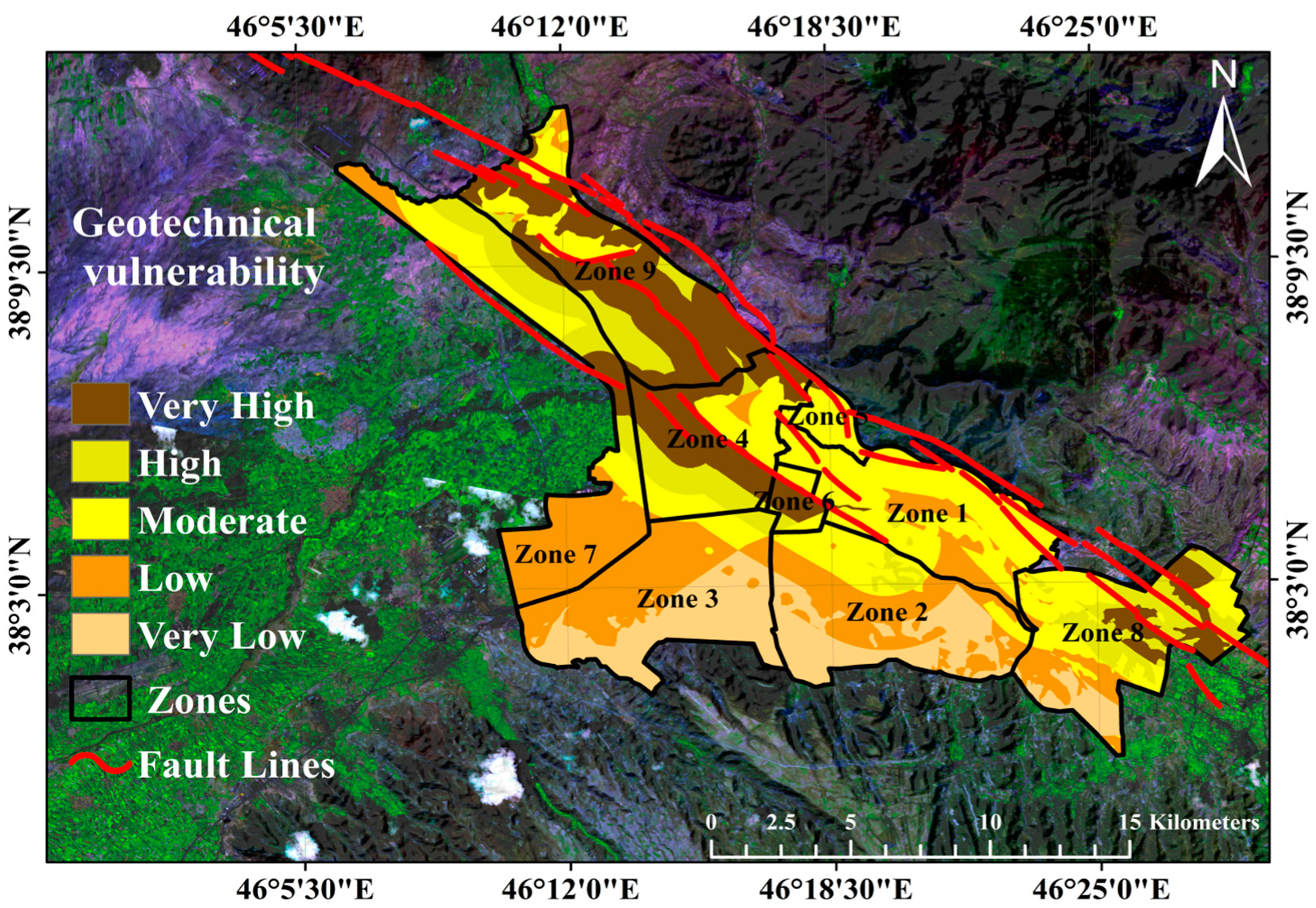
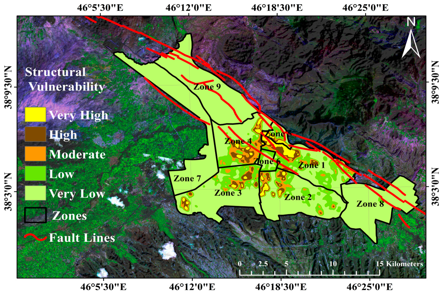
- Lastly, as the process of defining the vulnerability of residential buildings is along of all the geotechnical and structural factors of an earthquake, they should be measured simultaneously. Therefore, the seismic vulnerability of the residential buildings in Tabriz city was computed by superimposing the two acquired maps.
2.3. Kernel Density Estimation (KDE)
2.4. Data Preparation and Analysis
2.4.1. Geotechnical Vulnerability Factors
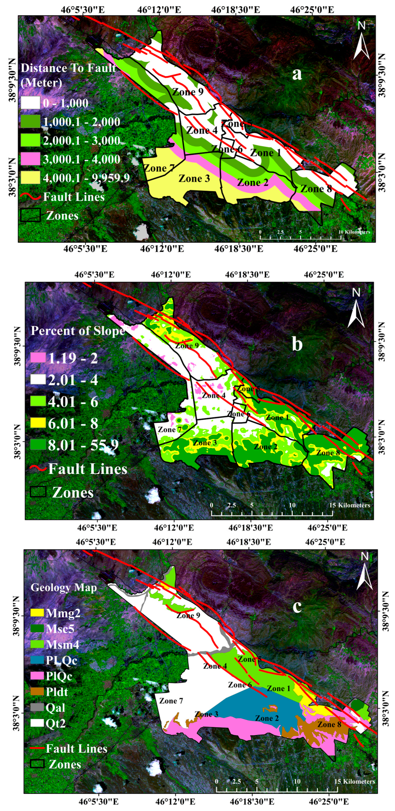
Distance to Fault
Slope
Geology
2.4.2. Factors Influencing Structural Vulnerability
Buildings Materials
Size of Buildings Blocks
Buildings Quality
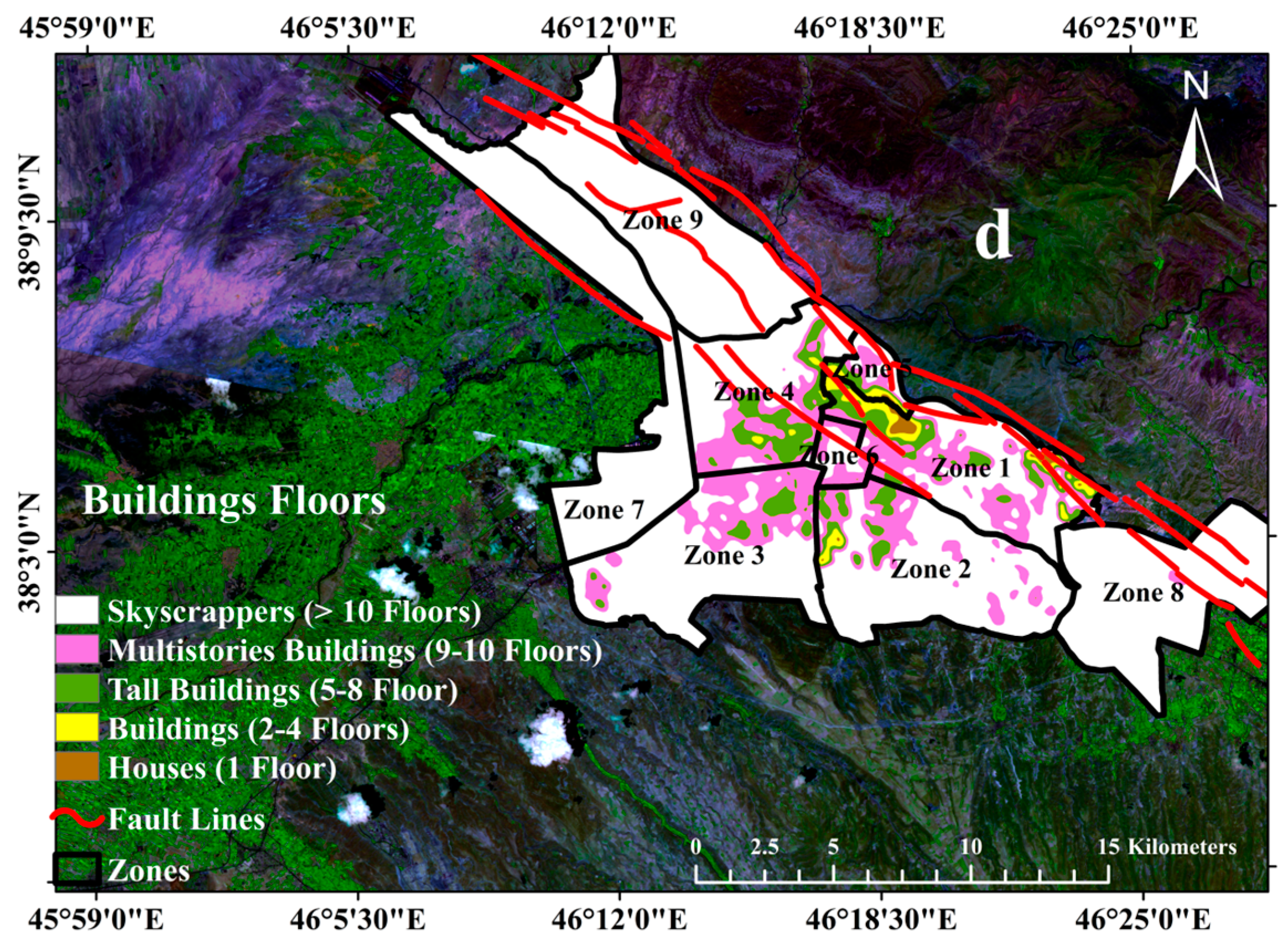
Buildings Floors
3. Results
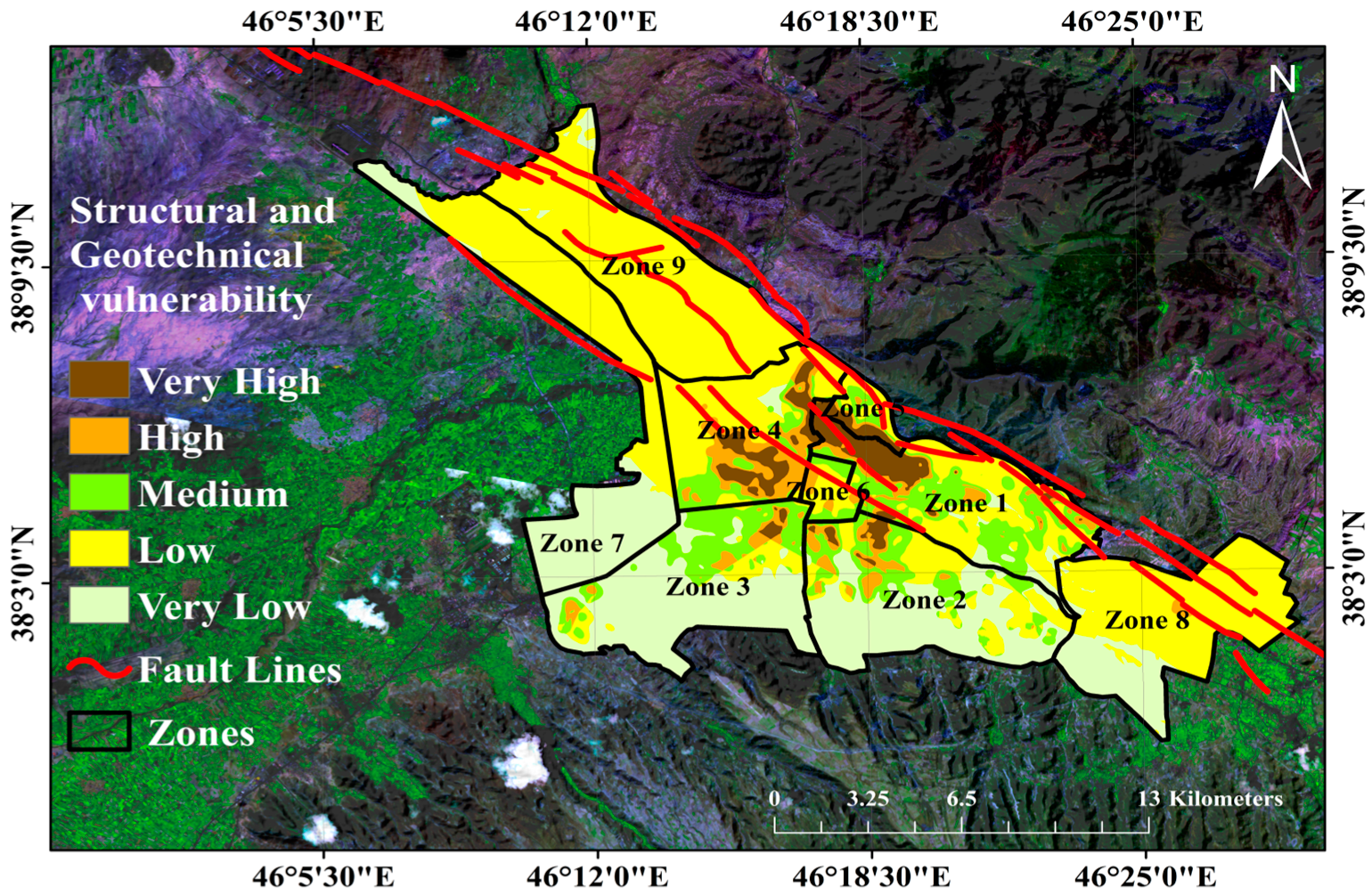
Generating Geotechnical, Structural and Overlay Maps
4. Discussion
- Buildings with very high geotechnical and structural vulnerability comprise 4.44% of buildings. The most vulnerable structures are situated in zones 5, 4 and 1, and require either demolition or reconstruction.
- Buildings with high geotechnical and structural vulnerability make up about 5.49% of the buildings in the city of Tabriz. These buildings are mostly located in zones 2, 4, 5 and 6, and their seismic vulnerability can be reduced by the process of retrofitting.
- Residential buildings which have moderate vulnerability from a geotechnical and structural vulnerability consists of nearly 12.28% of residential buildings in Tabriz city. Most of them are located in zones 6, 8 and 2 and a few in zones 1 and 3. Based on the age of construction, the process of retrofitting or occasionally destruction or renovation of the buildings can reduce vulnerability.
- Residential buildings which have low vulnerability from equally a geotechnical and structural approach constitute nearly 49.37% of all buildings. The buildings are situated in zones 9, 3, 1 and 6, which are the safest groups of residential buildings in Tabriz city.
- Residential buildings with very low vulnerability constitute 28.42% of the buildings. Therefore, taking into account the structural and geotechnical circumstances collectively, the buildings are considerably less vulnerable compared to the buildings outlined in classes 1 to 4 (Table 11).
5. Conclusions
Author Contributions
Funding
Acknowledgments
Conflicts of Interest
References
- Lantada, N.; Irizarry, J.; Barbat, A.H.; Goula, X.; Roca, A.; Susagna, T.; Pujades, L.G. Seismic hazard and risk scenarios for Barcelona, Spain, using the Risk-UE vulnerability index method. Bull. Earthq. Eng. 2010, 8, 201–229. [Google Scholar] [CrossRef] [Green Version]
- Rashed, T.; Weeks, J. Assessing vulnerability to earthquake hazards through spatial multicriteria analysis of urban areas. Int. J. Geogr. Inf. Sci. 2003, 17, 547–576. [Google Scholar] [CrossRef]
- Iervolino, I.; Manfredi, G.; Polese, M.; Verderame, G.M.; Fabbrocino, G. Seismic risk of R.C. Building classes. Eng. Struct. 2007, 29, 813–820. [Google Scholar] [CrossRef]
- Barbat, A.H.; Carreño, M.L.; Pujades, L.G.; Lantada, N.; Cardona, O.D.; Marulanda, M.C. Seismic vulnerability and risk evaluation methods for urban areas. A review with application to a pilot area. Struct. Infrastruct. Eng. 2009, 6, 17–38. [Google Scholar] [CrossRef]
- Carreño, M.-L.; Cardona, O.; Barbat, A. Urban seismic risk evaluation: A holistic approach. Nat. Hazards 2007, 40, 137–172. [Google Scholar] [CrossRef]
- Montoya, L.; Masser, I. Management of natural hazard risk in Cartago, Costa Rica. Habitat Int. 2005, 29, 493–509. [Google Scholar] [CrossRef]
- Alam, M.S.N.; Tesfamariam, S.; Alam, M.S.N. Gis-based seismic damage estimation: Case study for the city of Kelowna, BC. Nat. Hazards Rev. 2013, 14, 66–78. [Google Scholar] [CrossRef]
- Hashemi, M.; Alesheikh, A.A. A GIS-based earthquake damage assessment and settlement methodology. Soil Dyn. Earthq. Eng. 2011, 31, 1607–1617. [Google Scholar] [CrossRef]
- Hassanzadeh, R.; Nedovic-Budic, Z.; Alavi Razavi, A.; Norouzzadeh, M.; Hodhodkian, H. Interactive approach for GIS-based earthquake scenario development and resource estimation (karmania hazard model). Comput. Geosci. 2013, 51, 324–338. [Google Scholar] [CrossRef]
- HAZUS 99 Technical Manual; Federal Emergency Management Agency (FEMA): Washington, DC, USA, 1999.
- The Study on Seismic Micro Zoning of the Greater Tehran Area in the Islamic Republic of Iran; Final Report; Tehran Municipality, Japan International Cooperation Agency (JICA): Tehran, Iran, 2000.
- Karimzadeh, S.; Miyajima, M.; Hassanzadeh, R.; Amiraslanzadeh, R.; Kamel, B. A GIS-based seismic hazard, building vulnerability and human loss assessment for the earthquake scenario in Tabriz. Soil Dyn. Earthq. Eng. 2014, 66, 263–280. [Google Scholar] [CrossRef]
- Tang, A.; Wen, A. An intelligent simulation system for earthquake disaster assessment. Comput. Geosci. 2009, 35, 871–879. [Google Scholar] [CrossRef]
- Vicente, R.; Parodi, S.; Lagomarsino, S.; Varum, H.; Silva, J.A.R.M. Seismic vulnerability and risk assessment: Case study of the historic city centre of Coimbra, Portugal. Bull. Earthq. Eng. 2011, 9, 1067–1096. [Google Scholar] [CrossRef]
- Godfrey, A.; Ciurean, R.L.; van Westen, C.J.; Kingma, N.C.; Glade, T. Assessing vulnerability of buildings to hydro-meteorological hazards using an expert based approach—An application in Nehoiu valley, Romania. Int. J. Disaster Risk Reduct. 2015, 13, 229–241. [Google Scholar] [CrossRef]
- Rezaie, F.; Panahi, M. Gis modeling of seismic vulnerability of residential fabrics considering geotechnical, structural, social and physical distance indicators in Tehran using multi-criteria decision-making techniques. Nat. Hazards Earth Syst. Sci. 2015, 15, 461–474. [Google Scholar] [CrossRef]
- Arma¸s, I. Multi-criteria vulnerability analysis to earthquake hazard of Bucharest, Romania. Nat. Hazards 2012, 63, 1129–1156. [Google Scholar] [CrossRef]
- Hizbaron, D.R.; Baiquni, M.; Sartohadi, J.; Rijanta, R. Urban vulnerability in Bantul district, Indonesia—Towards safer and sustainable development. Sustainability 2012, 4, 2022. [Google Scholar] [CrossRef]
- Servi, M. Assessment of Vulnerability to Earthquake Hazards Using Spatial Multicriteria Analysis: Odunpazari, Eskisehir Case Study. Master’s Thesis, Middle East Technical University, Ankara, Turkey, 2004. [Google Scholar]
- Sinha, N.; Priyanka, N.; Joshi, P.K. Using spatialmulti-criteria analysis and ranking tool (smart) in earthquake risk assessment: A case study of Delhi region, India. Geomat. Nat. Hazards Risk 2016, 7, 680–701. [Google Scholar] [CrossRef]
- Kougkoulos, I.; Cook, S.J.; Jomelli, V.; Clarke, L.; Symeonakis, E.; Dortch, J.M.; Edwards, L.A.; Merad, M. Use of multi-criteria decision analysis to identify potentially dangerous glacial lakes. Sci. Total Environ. 2018, 621, 1453–1466. [Google Scholar] [CrossRef] [PubMed]
- Yalcin, M.; Gul, F.K. A GIS-based multi criteria decision analysis approach for exploring geothermal resources: Akarcay basin (Afyonkarahisar). Geothermics 2017, 67, 18–28. [Google Scholar] [CrossRef]
- Silavi, T.; Delavar, M.R.; Malek, M.R.; Kamalian, N.; Karimizand, K. An integrated strategy for GIS-based fuzzy improved earthquake vulnerability assessment. In Proceedings of the Second International Symposium in Geo-Information for Disaster Management, ISPRS, Goa, India, 25–26 September 2006; p. 6. [Google Scholar]
- Samadi Alinia, H.; Delavar, M.R. Tehran’s seismic vulnerability classification using granular computing approach. Appl. Geomat. 2011, 3, 229–240. [Google Scholar] [CrossRef]
- Moradi, M.; Delavar, M.R.; Moshiri, B. A GIS-based multi-criteria decision-making approach for seismic vulnerability assessment using quantifier-guided owa operator: A case study of Tehran, Iran. Ann. GIS 2015, 21, 209–222. [Google Scholar] [CrossRef]
- Alizadeh, M.; Ngah, I.; Hashim, M.; Pradhan, B.; Pour, A.B. A Hybrid Analytic Network Process and Artificial Neural Network (ANP-ANN) Model for Urban Earthquake Vulnerability Assessment. Remote Sens. 2018, 10, 975. [Google Scholar] [CrossRef]
- Maithani, S.; Sokhi, B.S. Radius: A methodology for earthquake hazard assessment in urban areas in a GIS environment, Case study Dehradun Municipal area. ITPI 2004, 3, 55–64. Available online: http://itpi.org.in/pdfs/july2004/chapter7.pdf (accessed on 2 September 2013).
- Gulati, B. Earthquake Risk Assessment of Buildings: Applicability of HAZUS in Dehradun, India. Master’s Thesis, ITC, Enschede, The Netherlands, 2006. [Google Scholar]
- Thapaliya, R. Assessing Building Vulnerability for Earthquake Using Field Survey and Development Control Data: A Case Study in Lalitpur Sub Metropolitan City, Nepal. Master’s Thesis, ITC, Enschede, The Netherlands, 2006; 103p. [Google Scholar]
- Cole, S.W.; Xu, Y.; Burton, P.W. Seismic hazard and risk in Shanghai and estimation of expected building damage. Soil Dyn. Earthq. Eng. 2008, 28, 778–794. [Google Scholar] [CrossRef] [Green Version]
- Nath, S.K.; Thingbaijam, K.K.S. Seismic hazard assessment—A holistic microzonation approach. Nat. Hazards Earth Syst. Sci. 2009, 9, 1445–1459. [Google Scholar] [CrossRef]
- Zahraie, M. and Ershad, L. Study on seismic vulnerability of building structures in Qazvin. J. Fac. Eng. 2005, 39, 287–297. (In Persian) [Google Scholar]
- Aghataher, R.; Delavar, M.R.; Nami, M.H.; Samnay, N. A Fuzzy-AHP decision support system for evaluation of cities vulnerability against earthquakes. World Appl. Sci. J. 2008, 3, 66–72. [Google Scholar]
- Amini Hosseini, K.; Hosseini, M.; Jafari, M.K.; Hosseinioon, S. Recognition of vulnerable urban fabrics in earthquake zones: A case study of the Tehran metropolitan area. J. Seismol. Earthq. Eng. 2009, 10, 175–187. [Google Scholar]
- Hataminejad, H.; Fathi, H.; Eshghabadi, F. Criterion vulnerability assessment earthquake about city, case study region 10 Tehran. J. Hum. Geogr. Res. 2009, 68, 1–2. (In Persian) [Google Scholar]
- Building and Housing Research Center (BHRC). Iranian Code of Practice for Seismic Resistant Design of Buildings, 1st ed.; Building and Housing Research Center: Tehran, Iran, 1988; p. 71. [Google Scholar]
- Çetinkaya, C.; Özceylan, E.; Erbaş, M.; Kabak, M. GIS-based fuzzy MCDA approach for siting refugee camp: A case study for southeastern Turkey. Int. J. Disaster Risk Reduct. 2016, 18, 218–231. [Google Scholar] [CrossRef]
- Kamelifar, M.J.; Rustei, S.; Ahadnejad, M.; Kamelifar, Z. The Assessment of road network vulnerability in formal and informal (slum) urban tissues to earthquake hazards with crisis management approach (Case study: Zone 1 Tabriz). J. Civ. Eng. Urban 2013, 3, 380–385. [Google Scholar]
- Hosseinzade Delir, K.; Khodabakhah Charkhaloo, M. The study of efficiency of street networks in earthquake (case study of zones 1 and 5 of Tabriz detailed Pland). Geogr. Plan. 2015, 18, 153–174. [Google Scholar]
- Ambraseys, N.N.; Melville, C.P. A History of Persian Earthquakes; Cambridge University Press: Cambridge, UK, 1982. (In Persian) [Google Scholar]
- Copley, A.; Jackson, J. Active tectonics of the Turkish-Iranian Plateau. TECTONICS 2006, 25, TC6006. [Google Scholar] [CrossRef]
- Jackson, J. Partitioning of strike-slip and convergent motion between Eurasia and Arabia in Eastern Turkey and the Caucasus. J. Geophys. Res. 1992, 97, 12471–12479. [Google Scholar] [CrossRef]
- Karimzadeh, S.; Cakir, Z.; Osmanoglu, B.; Schmalzle, G.; Miyajima, M.; Amiraslanzadeh, R.; Djamour, Y. Interseismic strain accumulation across the North Tabriz fault (NW Iran) deduced from InSAR time series. J. Geodyn. 2013, 66, 53–58. [Google Scholar] [CrossRef]
- Toksoz, M.N.; Arpat, E.; Saroglu, F. East Anatolia earthquake of 24 November, 1976. Nature 1977, 270, 423–425. [Google Scholar] [CrossRef]
- Djamour, Y.; Vernant, P.; Nankali, H.R.; Tavakoli, F. NW Iran-eastern Turkey present-day kinematics: Results from the Iranian permanent GPS network. Earth Planet. Sci. Lett. 2011, 307, 27–34. [Google Scholar] [CrossRef]
- Berberian, M.; Arshadi, S. On the evidence of the youngest activity of the North Tabriz Fault and the seismicity of Tabriz city. Geol. Surv. Iran 1976, 39, 397–418. [Google Scholar]
- Abich, O.W.H. Sur les derniers tremblement de terre dans la Perse septentrionale. Bull. Phys. Math. Acad. 1857, 316, 49–72. [Google Scholar]
- Wilson, A. Earthquakes in Persia. Bull. Sch. Orient. Stud. 1930, 6, 103–131. [Google Scholar] [CrossRef]
- Akoglu, A.M.; Jonsson, S.; Cakir, Z.; Ergintav, S.; Dogan, U.; Feng, G.; Zabcı, C. The Surface Deformation and Source Parameters of the October 23rd, 2011, Mw 7.1 Van (Turkey) Earthquake from InSAR, GPS and Field Observations; EGU General Assembly: Vienna, Austria, 2012. [Google Scholar]
- Ghayamghamian, M.R.; Mansouri, B.; Amini-Hosseini, K.; Tasnimi, A.A.; Govahi, N. Development of Fragility and Fatality Functions as Well as Site Amplification Factor in Tehran; Tehran Disaster Mitigation and Management Organization: Theran, Iran, 2012.
- Malczewski, J. GIS-based land-use suitability analysis: A critical overview. Prog. Plan. 2004, 62, 3–65. [Google Scholar] [CrossRef]
- Dodgson, J.S.; Spackman, M.; Pearman, A.; Phillips, L.D. Multi-Criteria Analysis: A Manual; Department for Communities and Local Government: London, UK, 2009. Available online: http://eprints.lse.ac.uk/12761/ (accessed on 2 September 2013).
- Saaty, T.L. The analytic Hierarchy Process: Planning, Priority Setting, Resource Allocation; McGraw-Hill: New York, NY, USA, 1980; 287p. [Google Scholar]
- Saaty, T.L.; Shih, H.S. Structures in decision making: On the subjective geometry of hierarchies and networks. Eur. J. Oper. Res. 2009, 199, 867–872. [Google Scholar] [CrossRef]
- Saaty, T.L. Decision making—The analytic hierarchy and network process (AHP/ANP). J. Syst. Sci. Syst. Eng. 2004, 13, 1–34. [Google Scholar] [CrossRef]
- Abudeif, A.M.; Abdel Moneim, A.A.; Farrag, A.F. Multicriteria decision analysis based on analytic hierarchy process in GIS environment for siting nuclear power plant in Egypt. Ann. Nucl. Energy 2015, 75, 682–692. [Google Scholar] [CrossRef]
- Malczewski, J. GIS and Multi-Criteria Decision Analysis; John Wiley: Toronto, ON, Canada, 1999. [Google Scholar]
- Rosenblatt, M. Remarks on Some Nonparametric Estimates of a Density Function. Ann. Math. Stat. 1956, 27, 832. [Google Scholar] [CrossRef]
- Parzen, E. On Estimation of a Probability Density Function and Mode. Ann. Math. Stat. 1962, 33, 1065. [Google Scholar] [CrossRef]
- Yalew, L.; Yamagishi, H.; Ugawa, N. Landslide susceptibility mapping using GIS-based weighted linear combination, the case in Tsugawa area of Agano River, Niigata Prefecture, Japan. Landslides 2004, 1, 73–81. [Google Scholar] [CrossRef]
- ESRI. Arc GIS Network Analyst Routing, Closest Facility, and Service Area Analysis; ESRI: Redlands, CA, USA, 2005. [Google Scholar]
- Jeong, J.S.; Moruno, L.G.; Blanco, J.H. A site planning approach for rural buildings into a landscape using a spatial multi-criteria decision analysis methodology. Land Use Policy 2013, 32, 108–118. [Google Scholar] [CrossRef]
- Huggenberger, P.; Epting, J. Urban Geology; Springer: Basel, Switzerland, 2011; ISBN 978-3-0348-0184-3. [Google Scholar]
- Arya, A.S. Design and construction of masonry buildings in seismic areas. Bull. ISET 1967, 4, 25–37. [Google Scholar]
- Japan International Cooperation Agency (JICA); Center for Earthquake and Environmental Studies of Tehran (CEST); Tehran Municipality. The Study on Seismic Microzoning of the Greater Tehran Area in the Islamic Republic of Iran; Japan International Cooperation Agency: Theran, Iran, 2000; p. 403.
- Zangiabadi, A.; Tabrizi, N. Tehran earthquake and spatial analysis on urban area vulnerability. J. Geogr. Res. (JGR) 2000, 38, 115–130. (In Persian) [Google Scholar]
- Sharifzadegan, M.H.; Fathi, H. Application of Seismic Risk Assessment Models in Urban Planning and Design. Soffeh (Journal of Architecture and Urban Planning Faculty of Shahid Beheshti University). 2008. Available online: http://www.sid.ir/en/ViewPaperprint.asp?ID=211079&varStr= (accessed on 2 September 2013). (In Persian).
- Zekai, S. Supervised fuzzy logic modelling for building earthquake hazard assessment. Expert Syst. Appl. 2011, 38, 14564–14573. [Google Scholar] [CrossRef]
- Tavakoli, B.; Tavakoli, S. Estimating the vulnerability and loss functions of residential buildings. Nat. Hazards 1993, 7, 155–171. [Google Scholar] [CrossRef]
- Ghayamghamian, M.R.; Khanzade, K. Buildings classification and determination of dam- age function for non-engineering in Bam city. JSEE 2008, 39, 2–10. [Google Scholar]
- Pelling, M.; Wisner, B. Disaster Risk Reduction: Cases from Urban Africa; Earthscan: New York, NY, USA, 2012. [Google Scholar]
- Ghajari, Y.E.; Alesheikh, A.A.; Modiri, M.; Hosnavi, R.; Abbasi, M. Spatial Modelling of Urban Physical Vulnerability to Explosion Hazards Using GIS and Fuzzy MCDA. Sustainability 2017, 9, 1274. [Google Scholar] [CrossRef]
- Mileu, N.; Queirós, M. Integrating Risk Assessment into Spatial Planning: RiskOTe Decision Support System. ISPRS Int. J. Geo-Inf. 2018, 7, 184. [Google Scholar] [CrossRef]
- Sadrykia, M.; Delavar, M.R.; Zare, M. A GIS-Based Fuzzy Decision Making Model for Seismic Vulnerability Assessment in Areas with Incomplete Data. ISPRS Int. J. Geo-Inf. 2017, 6, 119. [Google Scholar] [CrossRef]

| Weight/Rank | Intensities |
|---|---|
| 1 | equal |
| 3 | moderately dominant |
| 5 | strongly dominant |
| 7 | very strongly dominant |
| 9 | extremely dominant |
| 2, 4, 6, 8 | intermediate values |
| Reciprocals | for inverse judgments |
| Size | 1 | 2 | 3 | 4 | 5 | 6 | 7 | 8 | 9 | 10 |
| RI | 0 | 0 | 0.58 | 0.90 | 1.12 | 1.24 | 1.32 | 1.41 | 1.45 | 1.49 |
| Papered Data | Abbreviation | Scale | Source |
|---|---|---|---|
| Distance to fault | DF | 1.100000 | 1 |
| Percent of Slope | PS | 1.2000 | 6 |
| Geology | PG | 1.100000 | 2 |
| Buildings Materials Density | BMD | 1.2500 | 4 |
| Size of Building block Density | SBDD | 1.2500 | 4 |
| Quality of Buildings Density | QBD | 1.2500 | 5 |
| Buildings Floors Density | BFD | 1.2500 | 4 |
| Classification’s Type of Materials | Quality Code |
|---|---|
| Cemented block, iron, stone, the composition of brick and weak materials | 1 |
| Brick and iron | 2 |
| Reinforced concrete and other composite materials | 3 |
| Under construction | 4 |
| Metal skeleton | 5 |
| Classification of the Segmentation of Buildings (m2) | Rating |
|---|---|
| 0–200 square meters | 1 |
| 200.1–300 square meters | 2 |
| 300.1–400 square meters | 3 |
| 400.1–500 square meters | 4 |
| 500.1 square meters and higher | 5 |
| Classification of Building’s Quality | Quality Code |
|---|---|
| Destroyed | 1 |
| Repaired | 2 |
| Moderately repaired | 3 |
| Especial and under construction | 4 |
| Newly constructed and suitable | 5 |
| Geotechnical Sub-Factor Factors | Distance to Fault | Geology | Percent of Slope | |
|---|---|---|---|---|
| Distance to Fault | 1 | 3 | 3 | |
| Geology | 1/3 | 1 | 5 | |
| Percent of Slope | 1/3 | 1/5 | 1 | |
| ∑ | 1.66 | 4.2 | 9 | |
| Structural sub-Factors | Buildings Materials | Quality of Buildings | Size of Buildings Blocks | Buildings Floors |
| Buildings Materials | 1 | 3 | 5 | 7 |
| Quality of Buildings | 1/3 | 1 | 3 | 3 |
| Size of Buildings Block | 1/5 | 1/3 | 1 | 3 |
| Buildings Floors | 1/7 | 1/3 | 1/3 | 1 |
| ∑ | 1.67 | 4.66 | 9.33 | 14 |
| Main Factors | Geotechnical | Structural | ||
| Geotechnical | 1 | 2 | ||
| Structural | 1/2 | 1 | ||
| Σ | 1.50 | 3 | ||
| Geotechnical Sub-Factors | Distance to Fault | Geology | Percent of Slope | Weights | |
|---|---|---|---|---|---|
| Distance to Fault | 0.60 | 0.56 | 0.55 | 0.59 | |
| Geology | 0.30 | 0.36 | 0.40 | 0.35 | |
| Percent of Slope | 0.1 | 0.08 | 0.05 | 0.07 | |
| Consistency ratio: 0.05 | |||||
| Structural Sub-Factors | Buildings Materials | Quality of Buildings | Size of Buildings Blocks | Buildings Floors | Weights |
| Buildings Materials | 0.56 | 0.52 | 0.52 | 0.51 | 0.51 |
| Quality of Buildings | 0.28 | 0.26 | 0.23 | 0.27 | 0.26 |
| Size of Buildings Block | 0.07 | 0.10 | 0.10 | 0.14 | 0.10 |
| Buildings Floors | 0.09 | 0.12 | 0.09 | 0.08 | 0.09 |
| Consistency ratio: 0.09 | |||||
| Main Factors | Geotechnical | Structural | Weights | ||
| Geotechnical | 0.70 | 0.63 | 0.66 | ||
| Structural | 0.30 | 0.38 | 0.34 | ||
| Consistency ratio: 0.01 | |||||
| Vulnerability | Percent |
|---|---|
| Very High | 20.1 |
| High | 12.9 |
| Moderate | 29.3 |
| Low | 23.4 |
| Very Low | 14.3 |
| SUM | 100 |
| Vulnerability | Percent |
|---|---|
| Very High | 2.38 |
| High | 3.9 |
| Moderate | 4.93 |
| Low | 13.47 |
| Very Low | 75.32 |
| SUM | 100 |
| Vulnerability | Percent |
|---|---|
| Very High | 4.44 |
| High | 5.49 |
| Moderate | 12.28 |
| Low | 49.37 |
| Very Low | 28.42 |
| SUM | 100 |
| Vulnerability | Very High | High | Moderate | Low | Very Low | Percent |
|---|---|---|---|---|---|---|
| Zone1 | 12.50 | 16.40 | 32.00 | 37.10 | 2.00 | 100.00 |
| Zone 2 | 0.68 | 29.45 | 38.71 | 27.99 | 3.17 | 100.00 |
| Zone3 | 0.00 | 10.81 | 5.44 | 31.67 | 52.08 | 100.00 |
| Zone4 | 3.19 | 52.68 | 31.80 | 11.51 | 0.82 | 100.00 |
| Zone5 | 33.50 | 25.53 | 26.76 | 14.20 | 0.01 | 100.00 |
| Zone6 | 0.00 | 16.11 | 53.42 | 28.85 | 1.62 | 100.00 |
| Zone7 | 0.00 | 0.00 | 4.00 | 4.00 | 92.00 | 100.00 |
| Zone8 | 0.00 | 0.00 | 54.00 | 45.00 | 1.00 | 100.00 |
| Zone9 | 0.00 | 0.00 | 20.80 | 79.20 | 0.00 | 100.00 |
© 2018 by the authors. Licensee MDPI, Basel, Switzerland. This article is an open access article distributed under the terms and conditions of the Creative Commons Attribution (CC BY) license (http://creativecommons.org/licenses/by/4.0/).
Share and Cite
Alizadeh, M.; Hashim, M.; Alizadeh, E.; Shahabi, H.; Karami, M.R.; Beiranvand Pour, A.; Pradhan, B.; Zabihi, H. Multi-Criteria Decision Making (MCDM) Model for Seismic Vulnerability Assessment (SVA) of Urban Residential Buildings. ISPRS Int. J. Geo-Inf. 2018, 7, 444. https://doi.org/10.3390/ijgi7110444
Alizadeh M, Hashim M, Alizadeh E, Shahabi H, Karami MR, Beiranvand Pour A, Pradhan B, Zabihi H. Multi-Criteria Decision Making (MCDM) Model for Seismic Vulnerability Assessment (SVA) of Urban Residential Buildings. ISPRS International Journal of Geo-Information. 2018; 7(11):444. https://doi.org/10.3390/ijgi7110444
Chicago/Turabian StyleAlizadeh, Mohsen, Mazlan Hashim, Esmaeil Alizadeh, Himan Shahabi, Mohammad Reza Karami, Amin Beiranvand Pour, Biswajeet Pradhan, and Hassan Zabihi. 2018. "Multi-Criteria Decision Making (MCDM) Model for Seismic Vulnerability Assessment (SVA) of Urban Residential Buildings" ISPRS International Journal of Geo-Information 7, no. 11: 444. https://doi.org/10.3390/ijgi7110444
APA StyleAlizadeh, M., Hashim, M., Alizadeh, E., Shahabi, H., Karami, M. R., Beiranvand Pour, A., Pradhan, B., & Zabihi, H. (2018). Multi-Criteria Decision Making (MCDM) Model for Seismic Vulnerability Assessment (SVA) of Urban Residential Buildings. ISPRS International Journal of Geo-Information, 7(11), 444. https://doi.org/10.3390/ijgi7110444


