1. Introduction
Water quality monitoring in surface water is important, in order to obtain quantitative information on the waters characteristics. A challenge to measuring and monitoring water quality in situ is that it can be prohibitively expensive and time consuming. An alternative method to monitor water quality is by using satellite imagery. In the past few decades, remote sensing techniques and capabilities have been studied for monitoring several water quality parameters. Remote sensing is an effective tool for synoptic soil moisture assessment [
1], water and water level monitoring [
2], water demand modeling [
3], groundwater management, flood mapping [
4], and water quality monitoring [
5]. Depending on the study area, different satellite sensors have been used for water bodies monitoring. Thus, moderate resolution data from Sentinel-1 has been used for water resource management applications [
6], Landsat-8 [
7,
8], and Sentinel-2 [
9,
10,
11,
12] have been used for water bodies extraction and water quality monitoring, MODIS (Moderate Resolution Imaging Spectroradiometer) has been used for water quality assessment [
13]. Also, unmanned aerial vehicle (UAV) data have been used for water quality measurements [
14]. Landsat data have also been used for assessing detailed water quality parameters, such as suspended sediments, water transparency, chlorophyll-a, and turbidity [
15]. Water quality parameters help in decision-making regarding the further use of water based on its quality. However, the use of middle or low spatial resolution data (10–30 m) is not useful in monitoring small lakes, dams or rivers.
The main indicators of water quality are chlorophyll-a, water transparency, turbidity, and suspended particulate matter (SPM) [
16]. Chlorophyll-a is a commonly used measure of water quality as eutrophication level. Higher concentrations indicate poor water quality, usually when high algal production is maintained due to high chlorophyll-a and nutrient concentrations. Water transparency can also be used as an indicator of water quality. It is measured with the simple Secchi disk depth. Turbidity is the cloudiness or haziness of the water caused by large numbers of individual particles that are generally invisible to the naked eye. The measurement of turbidity is a key test of water quality. The measurement of total dissolved soils (TDS) is also important as it shows the concentration of dissolved solid particles in the water.
The use of satellite data to monitor water quality parameters has been mainly focused on developing algorithms with band combinations. The remote sensing algorithms for water quality assessment generally involves visible and infrared portion of the electromagnetic spectrum. Thus, turbidity, as one of the most important water quality parameters, has been monitored through remote sensing and several remote sensing studies have quantified the relationship between actual and estimated turbidity from satellite remote sensing data [
17,
18]. Similar investigations have been made for chlorophyll-a [
19], SPM [
20], water transparency [
21], etc. In order to establish the reliability of the remote sensing data, the results are compared with in situ measurements.
Building on this previous work, this study elaborates on monitoring water quality of small water bodies using high-resolution (5 m spatial resolution) data from RapidEye and implements indices widely used in the literature. However, since there are number of indices, in this study we only used indices that gave significant results or indices that needed clarification about their use. That is the case for one of the indices, that was used in the literature under different names, and was used for both turbidity and chlorophyll-a estimation.
Thus, in this study, we use eight different indices retrieved from high spatial resolution satellite sensors for estimating the correlation between the in situ and estimated water quality parameters: pH, electrical conductivity (EC), TDS, water transparency, water turbidity, depth, SPM, and chlorophyll-a. Specific objectives were: a) to retrieve water quality parameters from RapidEye reflectance, and b) to correlate satellite retrieved parameters with in situ measurements. The paper has been structured as follows: The materials and methods sections provide information about the study area, in situ and laboratory measurements, satellite data, and methodology. In the third part of the paper, the results are presented, followed by detailed discussion and conclusion.
2. Materials and Methods
2.1. Study Area
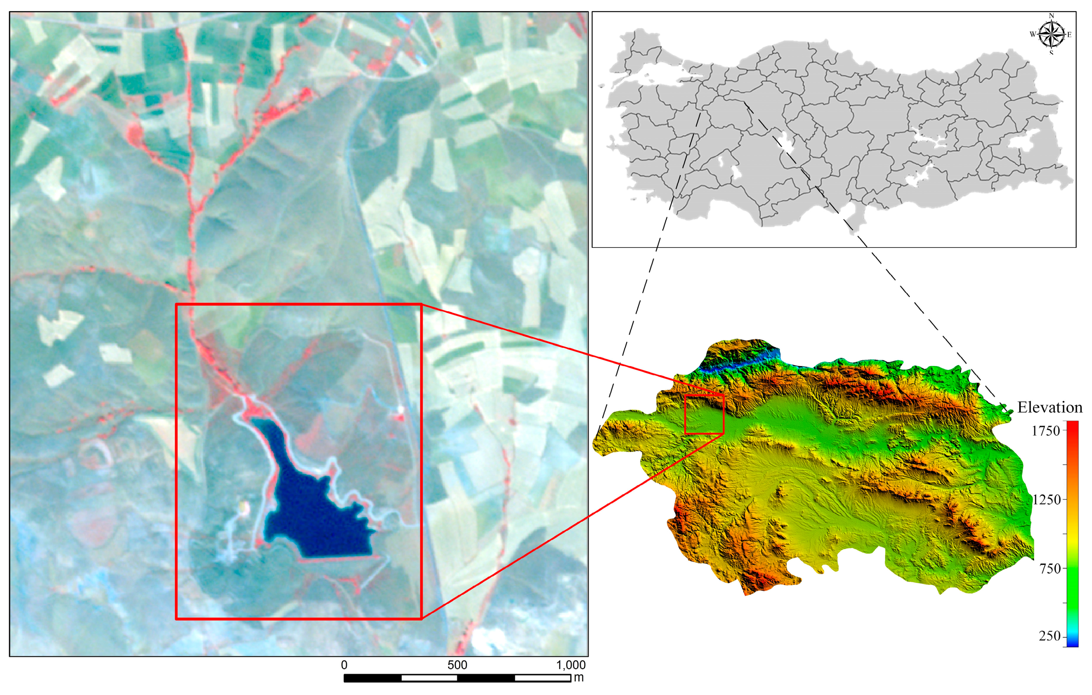
Borabey Dam, built in the period of 1991–1992, is located in Emirce Village on Bozdag slopes north of the Eskisehir city center (
Figure 1). The lake covers an area of approximately 166,559 m
2 at an altitude of approximately 924 m. Borabey Dam was built in order to support the local agriculture. Firstly, the lake was used as the Water Sports Center of Anadolu University in 1999. Later, it was planned to contribute to the drinking and utility water network of Eskisehir. The lake is mainly fed through rain and snow-melting, and one main stream. However, in 2011, this purpose was canceled. Details about Borabey Lake are given in
Table 1 [
22].
Eskisehir, which is located in the Central Anatolian region, generally has low rainfall. The annual rainfall varies between 300–500 mm. When it comes to the distribution of precipitation according to the seasons, the summer season is generally dry, autumn is rainy, while in spring and winter, there are relatively heavy rains. In winter, a significant proportion of precipitation falls in the form of snow. The climate is continental with very high temperatures during the summer days, but with cool nights, and cold and hard winters.
2.2. In situ and Laboratory Measurements
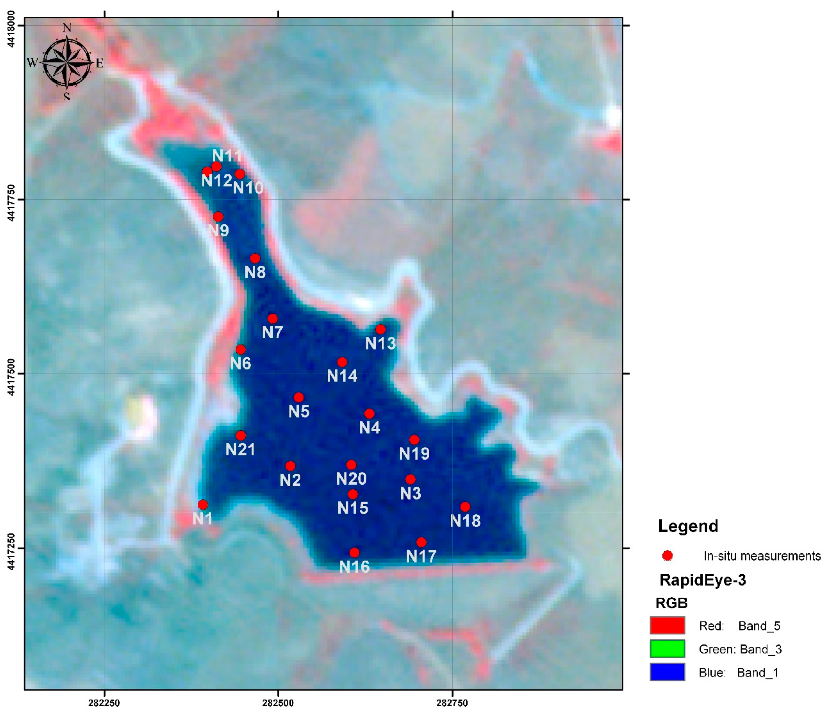
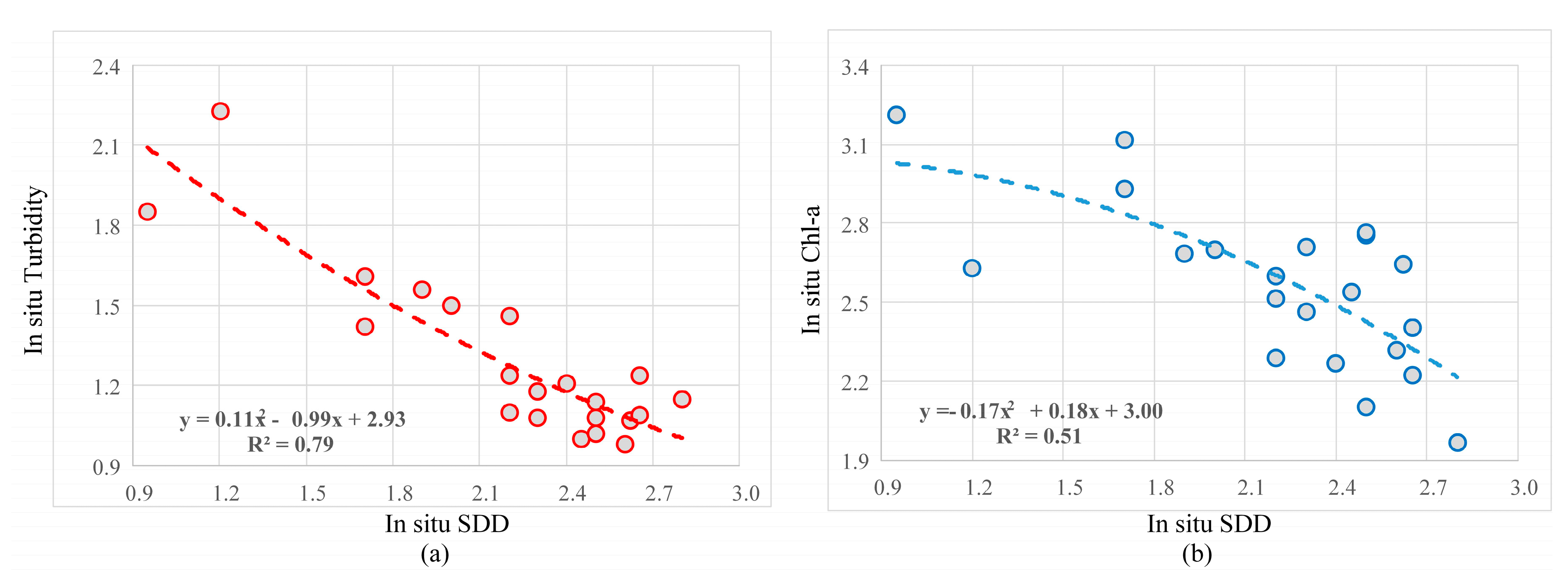
Water sample collections were initiated during the summer season, on August 12, 2014. Following a random sampling technique, water samples were collected and transferred to the laboratory to perform further analyses. In total, twenty-one water samples were collected from the Borabey Lake, and for each sample, the coordinates were recorded with a Global Positioning System (GPS) (Universal Transverse Mercator - UTM coordinates (World Geodetic System – WGS 84) Zone 36S). The samples were collected from the water surface. All of the samples were collected in glass bottles, while the samples used for the Chl-a analyses were transported in opaque bottles. For each sample, the following parameters were estimated: pH; electrical conductivity (EC); total dissolved solids (TDS); Water transparency (Secchi Disk Depth—SDD); depth; turbidity; suspended particulate matter (SPM); and chlorophyll-a (Chl-a). For all of the parameters, two measurements were made and then averaged. Since there was no significant difference between the two readings of the Chl-a, only the average values were given.
pH, EC and TDS values were measured with portable multimeter (Hach HQ40d). Turbidity was measured with a portable field type turbidity meter—(WTW—Turb® 355 IR) as NTU unit. A black/white stripe and 25-cm diameter Secchi disk was used for measuring SDD values. Especially, midday hours are preferred for the measuring SDD values. Chl-a values are measured with using Standard Methods (10200 H) analyzed with a spectrophotometer; SPM values were measured with a gravimetric method at the laboratory. In order to determine the SPM amount, the water samples were filtered through a membrane filter (0.45 µm pore size) and Sartorious filtration apparatus was used.
2.3. Satellite Data
One RapidEye product acquired three days after the in situ measurements, August 17, 2014, was used in this study. The RapidEye instrument acquires data in five different spectral bands (
Table 2) with 5 m spatial and approximately six days temporal resolution. The products included a standard geometric correction resampled to a 5 × 5 m pixel size. The data were collected from the Planet Explorer webpage [
23]. The RapidEye image with the in situ measurements are given in
Figure 2.
2.4. Methods
In situ measurements were used to evaluate eight different remote sensing indices that were successfully used and proposed in the literature for different remote sensing sensors. For simplicity, the indices have been renamed as I1-I8 (
Table 3). The structure of the first four indices is similar to the widely used Normalized Difference Vegetation Index (NDVI). The first index I1, Normalized Difference Water Index (NDWI) [
24], has been widely used for water bodies extraction. Even though the index has been developed to delineate open water features, it is also assumed that it can provide turbidity estimations of water bodies. The index is calculated from the green and near-infrared bands, which are highly sensitive to water contents. I2 is similar to the widely used Normalized Difference Chlorophyll Index (NDCI) [
25], but instead of red, uses the red-edge band. I3, or Normalized Difference Turbidity Index NDTI [
26,
27], uses red and green reflectances for estimating the turbidity in water bodies. However, the same index has been used for chlorophyll-a estimation [
25,
28,
29]. I4 was formed from the red and red-edge portion of the electromagnetic spectrum [
29]. I5-I7 are two band ratios, successfully used in the literature for water quality assessment. Namely, the green–red ratio, I5, and the red–red edge ratio have been successfully used for water quality monitoring, especially in chlorophyll-a estimation [
30,
31]. Similar to I5, I7 is a red–green ratio, used for total suspended matter (TSM) estimation [
31]. I8 is a three-band index used for turbidity estimation [
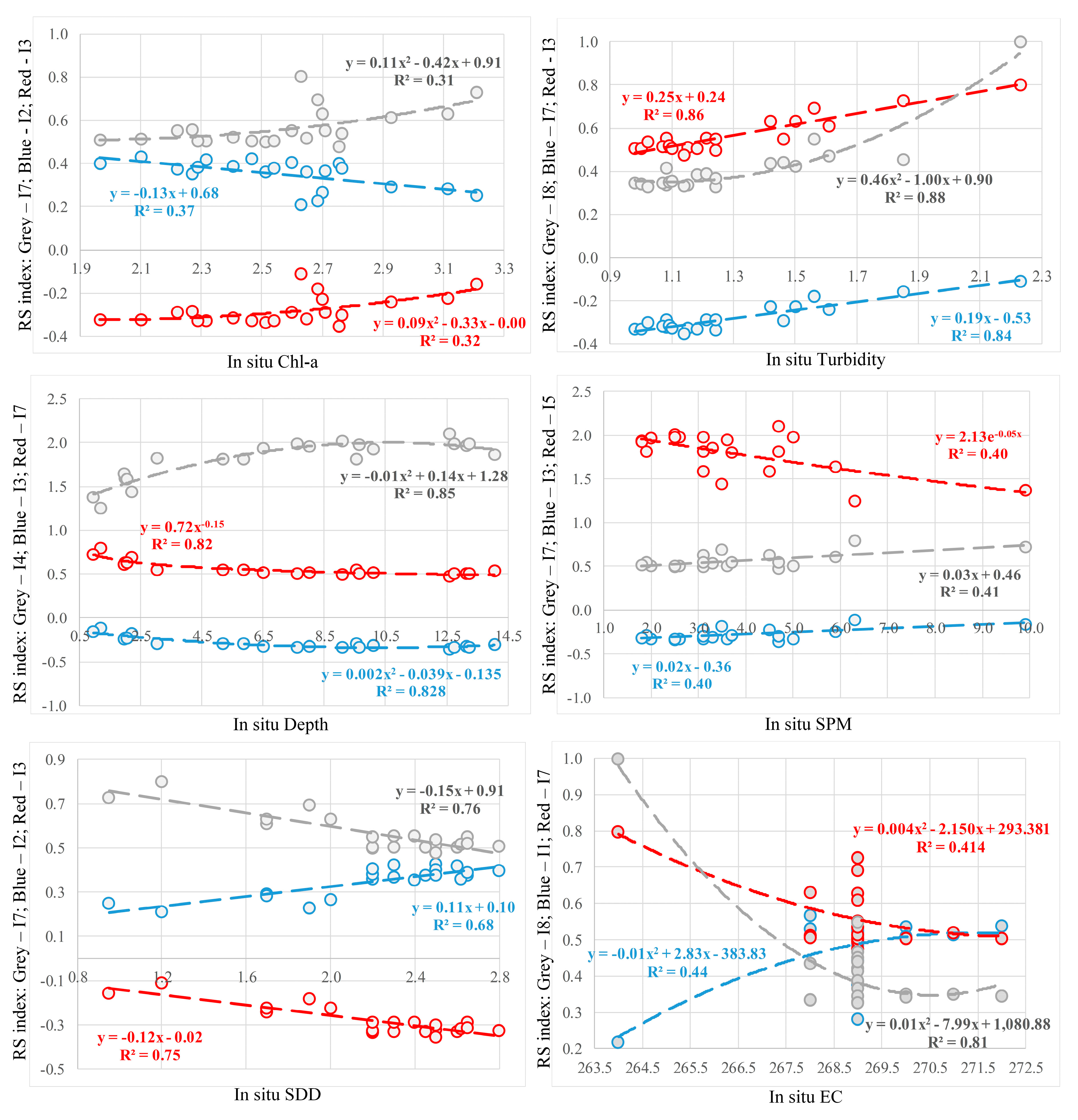
32]. The indices were then adjusted according to the RapidEye satellite sensor bands. Afterward, the results from the retrieved indices were statistically analyzed against the water quality parameters from the in situ and laboratory measurements. In addition, correlation analyses were made between every spectral band from RapidEye and every water quality parameters used in this study, and between the in situ and laboratory measurements of the water quality parameters.
4. Discussion
The main objective of the represented study was to investigate the ability of high spatial resolution satellite data for estimating water quality in small water areas. For that purpose, several successful algorithms that have been used by many authors to examine characteristic relationships between remotely sensed data and water quality parameters were selected and applied to high-resolution imagery. In this study, we investigated the possibility of using RapidEye products to monitor water quality parameters in Borabey Lake, Eskisehir, Turkey. Although it would be more suitable if the in situ and satellite data were acquired on the same day, since there was no significant hydrological event (e.g. rain) between 12 and 17 August 2014, and the main stream was dry during the summer season (July–August), it was assumed that the water quality did not changed during the short period of time. The study includes the elaboration of regression analysis to examine the relations between the reflectance of RapidEye bands and the water quality parameters. The parameters used in this study are: EC, TDS, water transparency, depth, turbidity, SPM, and chlorophyll-a. In situ measurements of the mentioned parameters were collected few days before the acquired satellite image. Since there are number of algorithms/indices in the literature for water quality monitoring, only the most successful were selected in this study. Also, it should be noticed that some of the indices have been used for monitoring different water quality parameters, such as the I3, that has been used as both chlorophyll-a and turbidity monitoring. For simplicity, the indices used in this study have been renamed as I1-I8 (
Table 3).
Several studies have explored the possibility of determining water quality with remote sensing images. Many of these studies consider Landsat imagery (30 m spatial resolution) to be high-resolution [
16], which may not be satisfactory for monitoring small water bodies. The comparison between two different remote sensing sensors indicates that higher spatial resolution offers higher accuracy in water quality parameters [
34,
35]. Taking into consideration that results of water quality are limited due to mixed pixels [
36], in this study we evaluate high-resolution (5 m spatial resolution) for monitoring water quality in small water bodies. To our knowledge, only few studies can be found in the literature exploring high remote sensing imagery (1–5 m) for water quality parameters, namely exploring only single parameter [
37].
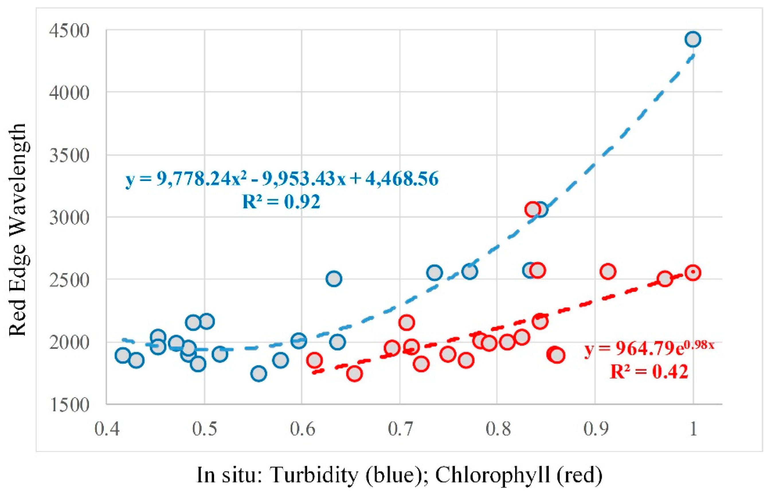
The main results of the study showed a significant relation between RapidEye bands and in situ and laboratory measurements. Similar to different studies, it was concluded that the most useful spectral information, needed to retrieve different water quality parameters are the red and NIR part of the spectrum [
38,
39]. However, our study also showed that red-edge part of the spectrum is more useful than the NIR for some of the parameters. For example, while EC and TDS showed higher correlation with the NIR band, all of the other parameters showed significant higher correlation with the red-edge band. The 690–730 wavelength range has been widely used in water quality monitoring [
31], supporting our findings in
Table 5.
As expected, I1 or NDWI, gave significant results in the water quality parameters. Although it was strongly suggested that it can be used for both water bodies extraction and turbidity monitoring [
24], the results in this study indicate that turbidity can be better monitored through a combination of red and green bands. Taking into consideration the higher correlation of red-edge bands with chlorophyll-a rather than NIR, similar to NDCI, I2 was constructed from green and red-edge bands. I5, a green–red ratio, which is also widely used for chlorophyll-a monitoring, gave lower correlation than I2. Also, I2 performed best with a linear correlation of R2 = 0.37. In the literature, I3 (a combination of red and green bands) has been used for both chlorophyll-a and turbidity estimation. The results in this study showed that I3 gave second-best result in the turbidity estimation among all of the investigated indices (R = 0.92), while in the chlorophyll-a estimation was ranked as third (R = 0.54).
The results in this study are slightly better than similar investigations; for example, Masocha et al. [
8] found that blue–red ratio provided strong positive relation between measured and retrieved turbidity in two different lakes (R = 0.90; R = 0.80). Different turbidity retrieval approaches showed a good correlation for two different study areas (R = 0.81) [
40].
The findings emphasize the use of both high-resolution remote sensing imagery and the red-edge portion of the electromagnetic spectrum for monitoring several water quality parameters in small water areas. Also, this study represents another case study that confirms the use of satellite remote sensing in water quality mapping and monitoring.
5. Conclusions
The presented study assessed the ability of high-resolution satellite sensor to monitor several water quality parameters in small water bodies, such as Borabey Lake in Eskisehir, Turkey. The relation between the in situ measurements, as well as the relation between each RapidEye band, and indices retrieved from RapidEye data were investigated. The main findings of this study proved the ability of RapidEye sensor in water quality estimation with high correlation between the in situ data and the RapidEye reflectance. The results showed a high sensitivity of the water quality parameters in the red, red-edge, and NIR part of the spectrum. The highest correlation has been noticed between in situ turbidity and the red-edge band (r2 = 0.92). Also, among the investigated water quality indices, the highest correlation was noticed for turbidity estimation (r2 = 0.88).
Investigating different indices, widely used in the literature, it was concluded that some are more successful than others. Thus, although some of the indices were used for both chlorophyll-a and turbidly estimation (I3), the finding of this study showed that chlorophyll-a can be best observed with combination of green and red-edge bands, while good turbidity estimation can be obtained with combination of red and green portions of the spectrum (I3 and I6). As expected, the same combination can be used for estimating water transparency. No significant correlation between red and red-edge bands was observed.
In order to improve the results of this study, a higher number of in situ measurements may be needed. Also, different water quality parameters with high-resolution satellite imagery should be observed. As the algorithms used in this study are easy to implement, we recommend further analyses in different study areas at different seasons of the year in order to get a wider range of values of water quality. Similar studies should be conducted in both turbid and clear water in order to support the results and encourage remote sensing data in water quality monitoring.


