Article

Prediction of Oil Source Fault-Associated Traps Favorable for Hydrocarbon Migration and Accumulation: A Case Study of the Dazhangtuo Fault in the Northern Qikou Sag of the Bohai Bay Basin

1
Heilongjiang Oil and Gas Reservoir Forming Mechanism and Resource Evaluation Key Laboratory, Northeast Petroleum University, Daqing 163318, China
2
Development Research Institute of Jidong Oilfield, Tangshan 063004, China
3
SINOPEC Petroleum Exploration and Production Research Institute, Beijing 100083, China
*
Author to whom correspondence should be addressed.
Processes 2024, 12(8), 1609; https://doi.org/10.3390/pr12081609
Submission received: 7 June 2024 / Revised: 26 July 2024 / Accepted: 29 July 2024 / Published: 31 July 2024
(This article belongs to the Section Energy Systems)

Abstract

:
In order to study the distribution pattern of oil and gas near the lower-source, upper-storage type of oil source faults in the hydrocarbon-bearing basins, a set of prediction methods favourable to oil and gas migration and accumulation were established by superimposing the parts of the oil source fault-associated traps, the contiguously distributed sand bodies and the lateral sealing position of faults. The trap associated with a fault can be determined by the fault’s convex part on the fault plane’s morphology map, the fault throw displacement curve and the intersection of faults on the structure map. The set of sand bodies can be determined by the sand-to-shale ration of the formation. The lateral sealing position of faults can be investigated by the shale content of the fault. This study is based on our case study of the Dazhangtuo Fault in the lower sub-member of the 1st member (Es1L) of the Shahejie formation in the northern Qikou Sag of Bohai Bay Basin. The results illustrate 4 fault nose traps formed by fault line deflection in the Es1L formation of the Dazhangtuo Fault, 2 each in the middle and eastern end. The Dazhangtuo Fault is favorable for oil and gas migration except at the eastern and western ends and the middle part of the fault. The fault-associated traps in the Es1L formation that are highly favorable for hydrocarbon migration and accumulation (overlapping site of associated traps and favorable location for oil and gas migration) are distributed in the eastern and central parts of the Dazhangtuo Fault. In contrast, those moderately favorable for hydrocarbon migration and accumulation (associated trap at a certain distance from the favorable location for oil and gas migration in the Dazhangtuo Fracture) are locally distributed in the east. Both traps are conducive to accumulating hydrocarbons from the underlying source rock in the Es3 formation. Such observations are consistent with the current confirmed hydrocarbon distribution, thus validating the feasibility and accuracy of predicting the distribution of traps related to oil source faults favorable for hydrocarbon migration and accumulation, it can be used to guide the exploration of the lower-source, upper-storage type of hydrocarbon accumulations in the hydrocarbon-bearing basins.

1. Introduction

In the hydrocarbon-bearing basins, when the source rock is spaced from the reservoir by multiple sets of mudstones, the oil and gas cannot be transported to the reservoir through the pores, it can only be transported upward through the oil source fault (i.e., the faults that connect the source rock with the studied layer and are active during the period of hydrocarbon accumulation), thus, the source rock it control the accumulation of hydrocarbon [1,2]. Hydrocarbons are mainly gathered in the oil source fault-associated traps, mostly fault noses or blocks, to form hydrocarbon accumulations [3]. However, practical exploration demonstrates that not all oil source fault-associated traps have oil and gas, hydrocarbons only accumulate in traps that facilitate migration [4,5]. Therefore, accurately detecting the oil source fault-associated traps that facilitate migration is crucial to exploring oil and gas near oil source faults in the ‘lower-source, upper-storage’ type of play in hydrocarbon-bearing basins.
Much research has been carried out by scholars on the associated traps of oil source faults conducive to oil and gas accumulation, which is mainly based on the following three priors: 1. The associated traps are formation in the vicinity of the oil source faults [6,7,8,9]. It is believed that if the associated traps of oil source faults are developed, they can gather oil and gas to form accumulations. The oil source fault-associated traps favor hydrocarbon accumulation. 2. There are developed sand bodies in the oil source fault-associated traps [10,11,12]. The oil source fracture-associated traps are believed to be favorable for oil and gas accumulation only when the sand body is developed. 3. The oil source fault lateral sealing [13,14,15,16,17]. It is believed that hydrocarbon can only accumulate in the traps when the fault displays lateral sealing. The above three research directions are essential to deeply understand the distribution laws of oil and gas shows near the ‘lower-source, upper-storage’ type of play in hydrocarbon-bearing basins and achieve efficient oil and gas exploration. Traditional seismic interpretation techniques focus on converting various geophysical information into lithology, hydrocarbon content and rock mechanical properties to infer subsurface structures. However, this technique has many limitations, resulting in less accurate interpretation results due to multiple interpretations of seismic data, seismic wavelength limitations, incomplete imaging and other factors. In addition to this, due to the limitations of people’s level of understanding and research methods, there is a lack of geological theories to guide the identification of oil source fracture-associated enclosures, resulting in the inaccurate understanding of the types of oil source fracture-associated enclosures and their distribution sites. Furthermore, the lack of integration with the oil and gas migration characteristics of the oil faults makes it unable to accurately predict the oil source fault-associated traps conducive to oil and gas migration and accumulation in the subsurface. It will produce inevitable risks in guiding oil and gas exploration. Therefore, the research on the prediction of oil source fault-associated traps favorable for hydrocarbon accumulation is crucial for an in-depth understanding of oil and gas accumulation near the oil source faults in ‘lower-source, upper-storage’ type of play in the hydrocarbon-bearing basins to have more efficient oil and gas exploration.
This study presents an analysis of the distribution pattern of the oil and gas of oil source faults in hydrocarbon-bearing basins based on oil source fault associated traps. Utilizing the drilling data to calculate the sand-to-shale ratio of the target the formation at the oil source fault needed. Subsequently, the fault throw, the thickness of sedimentary layer and shale content is obtained by logging data and seismic data. Determination of the contiguously distributed sand bodies and the lateral sealing position of faults is accomplished by the above methods. The two are used in conjunction with associated traps to predict traps that are favourable for hydrocarbon migration and accumulation. This prediction method is simple and practical, providing valuable guidance for the exploration of the lower-source, upper-storage type of hydrocarbon accumulations in the hydrocarbon-bearing basins.

2. Geological Setting

Bohai Bay Basin is a large petroliferous basin in eastern China, covering an area of about 20 × 104 km2 [18]. It is divided into 7 depressions by 4 uplifts, with the Huanghua Depression located in the center (Figure 1a) [19]. The Qikou Sag is the largest sag in the Huanghua Depression and is an intracontinental rift lake basin [20]. Due to multi-stage tectonic movement, a large number of major faults were developed in the depression [18]. These faults include the Banqiao Fault, Dazhangtuo Fault, Nandagang Fault, and Gangdong Fault (Figure 1b).
The Dazhangtuo Fault is situated in the north of the Qikou Sag of the Bohai Bay Basin, extending from the basement to near the surface. The fault is about 21.3 km long and is a northeast-oriented normal fault. It dips towards the southeast with a dip angle ranging from 55°~62°. The strata revealed in the Qikou Sag includes the Paleogene and the Neogene Formation. The Paleogene strata are further divided into Kongdian, Shahejie, and Dongying Formations, and the Neogene strata consist of the Guantao and Minghuazhen Formations (Figure 2). The third and second members of Shahejie formation are composed of dark gray mudstone and sandstone, respectively, and indicating a lacustrine deposition environment. During the deposition of the first member of the Shahejie formation, the depression was dominated by a lake delta carbonate platform, with mudstone, sandstone, and limestone deposited [19]. Most of faults within the study area are connected with source rocks of the 3rd member of the Shahejie formation or the 1st member of the Shahejie formation, forming oil source faults. The most abundant oil and gas horizon is the lower Shahejie sub-member, and the oil and gas are mostly derived from the underlying source rock of the third Member of the Dazhangtuo Fault.

3. Methods

3.1. The Trap Associated with Oil Source Fault Is Conducive to Oil and Gas Migration and Accumulation

The oil source fault associated trap favorable for hydrocarbon accumulation is the one that spatially overlaps with the favorite site of oil source fault for transporting oil and gas. Oil and gas will accumulate in the oil source fault associated trap close to the favorite transporting site of the conduit fault after the interception and migration of oil and gas generated from the source rock by the fault. In this scenario, the trap favors hydrocarbon migration and accumulation. In contrast, if the oil source fault associated trap is far away from the favorable transporting site of the fault, the trap will not be valid for hydrocarbon accumulation due to the lack of hydrocarbon input from the fault migration.

3.2. Prediction of Traps Associated with Oil Source Faults Conducive to Hydrocarbon Migration and Accumulation

In predicting the oil source fault-associated traps favorable for oil and gas transportation, it is necessary to delineate the development location of oil source fault-associated traps and the favorable sites of oil source faults for transporting oil and gas.

3.2.1. Prediction of the Development Site of Oil Source Fault-Associated Traps

To identify the development location of oil source fault-associated traps, we must first understand the type of oil source fault-associated traps. As shown in the literature [21], there are three dominant types of oil source fault-associated traps: Displacement gradient anticline trap, Fault line deflection anticline trap, and Cross-fault block trap. Figure 3 shows the detailed development characteristics of the three types. Due to the difference in the types of oil source fault-associated traps, the trap’ s formation mechanisms and development locations also vary. Displacement gradient anticline traps are mainly developed in the footwall of isolated coherent faults or the hanging and foot walls of the hard-linked segmentally grown faults (Figure 3). Once the isolated coherent fault is formed, the fault length remains the same while the fault throws increase. The Fault line deflection anticline trap is primarily developed in the hanging wall of the isolated coherent or jointly developed fault and at the convex location of the wave-like fault bend along the strike (Figure 3). Figure 3 also illustrates that cross-fault block traps are dominantly developed at the intersection of two or more faults. As the formation mechanism and distribution of different associated traps differ, their prediction methods also vary. The site of a displacement gradient anticline traps can be determined by the minimum and maximum fault throw using the fault throw displacement curve, as shown in Figure 3. The development site of fault line deflection anticline traps can be determined by identifying the fault’s convex part on the fault plane’s morphology map, as shown in Figure 3. The development site of the cross-fault block trap is determined by the intersection of two or more faults on the structure map (Figure 3).
The development of the sand body and the lateral sealing properties of the fault also influences the hydrocarbon trapping capabilities of these fault-associated traps. The fault-associated traps can only trap oil and gas with developed sands and lateral fault seals. The sand-to-shale ratio of the target the formation at the oil source fault needed for the prediction is available from the drilling data. The position of contiguously distributed sand bodies in the target formation is determined by the prediction method described in the literature [22,23] (Figure 4b). The sand-to-shale ration of the formation at fault needed for the prediction is available from the drilling data. In predicting the seal part of the oil source fault in the target formation, the fault throw of oil source faults within the target formation, the thickness of the sedimentary layer displaced by the oil source fault, and the shale content are three fundamental input values obtained from drilling and seismic data. The shale content of the oil source fault within the target formation is obtained after applying the related method detailed in the literature [24]. Afterward, the sites of fault forming a lateral seal in the target formation are determined using the study method of fault lateral seal described in the literature [15,25]. The shale content of the oil source fault in the target formation is obtained after applying the related method detailed in the literature [24]. Figure 4c demonstrates the prediction process.

3.2.2. Prediction of the Favorable Sites for Oil Source Fault Transporting Oil and Gas

To determine the favorable sites for the oil source fault transporting oil and gas, it is necessary to identify the location of the development of the trap associated with the oil source fault, the development of fractures associated with faults is influenced by the speed of their activity (which can be expressed in terms of activity rate), the higher the activity rate, the more developed the associated faults are conversely, it is undeveloped. We use seismic data to split the faulted sedimentary layers in the target formation into different types. Then, we locate the oil source faults that connect the source rock and target layers and are active during the oil and gas generation period. The present-day fault throw of the oil source fault in the corresponding layer (target layer) is obtained from seismic data. We use the maximum fault throw subtraction method [26,27] to derive the paleo fault throw during the hydrocarbon formation period. Afterward, the paleo fault throw is divided by the period of active faulting to get the paleo activity rate of the oil source fault (Figure 5). The minimum activity rate required for the oil source fault to transport hydrocarbons can be determined by determining the paleo activity rate of the oil source faults at known well sites in the study area with hydrocarbon presence in the corresponding layers (target layers). Based on this, we can get the minimum paleo activity rate of the faults near the oil and gas distributied area [17], as shown in Figure 3. Furthermore, the favorable transport sites of the oil source fault can be determined by comparing the minimum activity rate required for the fault to transport hydrocarbon with the paleo activity rate of the oil source fault [28], as shown in Figure 5.
By superimposing the delineated development locations of the oil source fault associated trap and the favorable hydrocarbon transport sites of the oil source fault and taking the coupling part of the two, we can identify the positions of the oil source fault associated trap that is beneficial to the oil and gas migration and accumulation.

4. Results and Discussion

Based on the prediction results in the previous section, we found that traps developed in the lower first member of the Shahejie formation (Es1L) associated with the Dazhangtuo Fault that are favorable for oil and gas migration and accumulation. Afterward, the relationship between the prediction results and the current oil and gas show in the Es1L formation near the Dazhangtuo Fault is compared. The high agreement in distribution between the two proves the accuracy of this study in predicting the oil source fault-associated traps that are favorable for oil and gas migration and accumulation.
The Dazhangtuo Fault connects the underlying Es3 source rock and the target Es1L formation. It is active during the period forming hydrocarbon accumulation, which is the middle and late deposition period of the Minghuazhen formation [29]. Therefore, it is the oil source fault for the Es1L formation. Figure 6 displays that the current oil and gas show in the Es1L formation near the Dazhangtuo Fault is located in the fault’s eastern and central parts, with relatively more distribution in the eastern part than the central part. The traps mainly influence this in the Es1L formation associated with it, that are conducive to oil and gas migration and accumulation. Therefore, predicting such associated traps that are favorable for oil and gas accumulation is essential for oil and gas exploration in the Es1L formation.
We used 3D seismic data to obtain the fault throw displacement curve of the Dazhangtuo Fault (Figure 7). Figure 7 illustrates that it is developed following the isolated coherent growth mechanism. The fault-associated trap belongs to the fault line deflection anticline trap type. The seismic-related data were used to trace the burial depth of the fault plane at different horizons. Afterward, the stratigraphic paleo burial depth recovery method [30] is used to recover the paleo burial depth of the fault surface during the hydrocarbon formation period (middle and late deposition of the Minghuazhen formation [29]) and build the related distribution map of the fault plane (Figure 8). The Dazhangtuo Fault has four fault line deflections in the Es1L formation that produced four fault nose traps distributed in the centre and east. Figure 9 shows that, except for the western and eastern ends of it, the sand-to-shale ratio of the Es1L formation is all above the minimum value of the sand-to-shale ratio required for the sand body to connect in the formation (i.e., 15%). Therefore, all of these positions have a contiguous distribution of sand bodies. Figure 10 demonstrates that, except for the western part of it, the shale content of fault rocks within the Es1L formation is greater than the minimum value of the shale content required for the fault to laterally seal oil and gas (i.e., 27%), forming a valid lateral seal.
By superimposing the development characteristics of the associated traps of the Dazhangtuo Fault, the position with connected sand body distribution, and the lateraly sealing location of the fault, we can determine the associated traps of the Dazhangtuo Fault in the Es1L formation. The distribution of these traps is mainly in the eastern and central parts of the fault, as shown in Figure 11.
The seismic data is used to measure the fault throw of the Dazhangtuo Fault in the Es1L formation. Then, the maximum distance subtraction method [26,27] is utilized to recover the paleo fault throw during the period of hydrocarbon generation, which is the middle and late stages of the Minghuazhen deposition [29]. Dividing the paleo fault throw by the period with active faulting, the paleo activity rate of the Dazhangtuo Fault at that time was solved, as shown in Figure 12. Figure 12 shows that the paleo activity rate of the Dazhangtuo Fault is relatively large in the middle, with a gradual decrease towards the east and west. The minimum paleo activity rate decreases to less than 2 m/Ma at the east and west ends of the fault. The favorable location of the Dazhangtuo Fault for oil and gas migration is also displayed in Figure 12. All parts of the Dazhangtuo Fault are favorable for oil and gas migration, except for the fault’s eastern ends, central parts, and western ends.
By superimposing the locations of the traps associated with the Dazhangtuo Fault in the Es1L formation and the favorable sites for oil and gas migration, we can determine the associated traps of the Dazhangtuo Fault in the Es1L formation that are favorable for oil and gas migration and accumulation. Figure 6 illustrates that the traps highly favorable to oil and gas migration and accumulation are mainly distributed in the eastern and central parts of the fault. In contrast, the traps moderately favorable for oil and gas migration are in the eastern part of the Dazhangtuo Fault.
Figure 6 shows that the current oil and gas in the Es1L formation near the Dazhangtuo Fault are mainly in its eastern and central parts, with the most oil and gas distributed in the eastern part. It is precisely distributed in and near the Es1L formation associated with the traps of the Dazhangtuo Fault, which is conducive to oil and gas accumulation. Only at these positions can the oil and gas generated from the underlying Es3 source rocks migrate through the favorable transport sites of the Dazhangtuo Fault toward the overlying Es1L formation and accumulate in the fault-associated traps. As a result, oil and gas are discovered at the traps by drilling.

5. Conclusions

  • The oil source fault-associated trap favorable for oil and gas migration and accumulation refers to the coupling between the location of a oil source fault-associated trap and the favorable transport sites of oil and gas. The development degree of such traps is positively correlated with the amounts of oil and gas that migrated and accumulated in the traps.
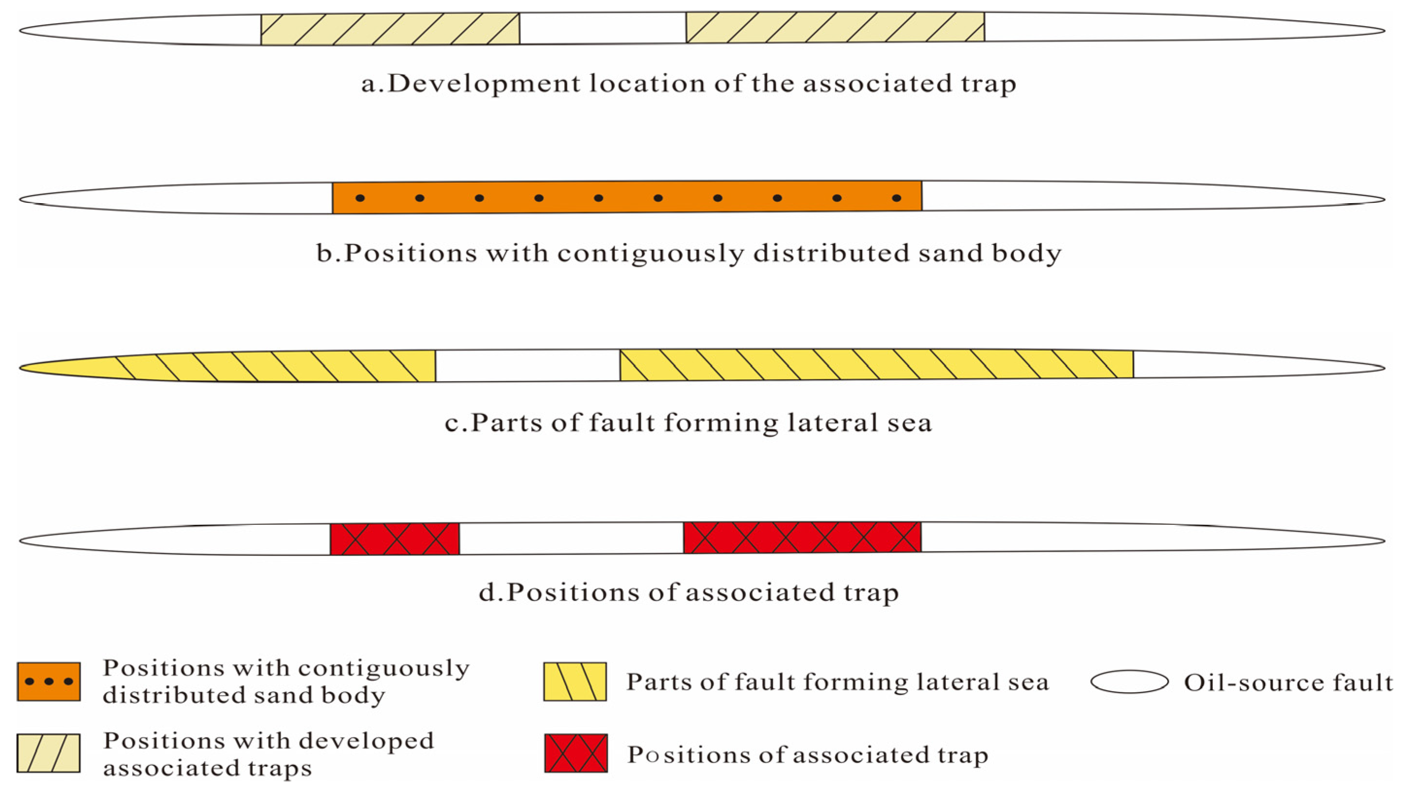
  • The location of fault-associated traps, contiguous sand distribution locations, and the positions of faults with the lateral seal are described in turn. By integrating the results with the favorable transport sites of oil source fault, we can locate the oil source fault-associated traps favorable for hydrocarbon migration. Our case study has proven the accuracy of the prodiction of oil source fault-associated traps favorable for oil and gas migration and accumulation.
  • The Dazhangtuo Fault in the northern part of the Qikou Depression in the Bohai Bay Basin has four fracture line deflections in the Es1L formation that are distributed in the central and eastern parts. Three of these are located in the central part are associated enclosures that are most favorable for oil and gas migration and accumulation (overlapping site of associated traps and favorable location for hydrocarbons to accumulate), while the other is a moderately favorable one (associated trap at a certain distance from the favorable location for oil and gas migration in the Dazhangtuo Fracture) are located in the eastern part. These traps are conducive to the accumulation of the hydrocarbon generated from the underlying Es3 source rock, which is consistent with the current oil and gas show near the Dazhangtuo Fault.
  • This study is targeted chiefly at predicting the associated traps of oil source faults in siliciclastic hydrocarbon-bearing basins favorable for oil and gas migration and accumulation; it can be used to guide the exploration of the lower-source, upper-storage type of hydrocarbon accumulations in hydrocarbon-bearing basins.

Author Contributions

Conceptualization, L.M. and H.Y.; methodology, L.M.; software, L.M.; validation, L.M., H.Y. and Y.Z. (Yaxiong Zhang); formal analysis, Y.Z. (Yaxiong Zhang); investigation, Y.Z. (Yunfeng Zhang); resources, Y.Z. (Yunfeng Zhang); data curation, L.M.; writing—original draft preparation, L.M.; writing—review and editing, L.M. and H.Y.; visualization, L.M.; supervision, H.Y.; project administration, H.Y.; funding acquisition, H.Y. All authors have read and agreed to the published version of the manuscript.

Funding

This research was funded by the Natural Science Foundation of Heilongjiang Province, item number LH2022D013 and LH2023D005. This work was also supported by Central Support Project for Young Talents in Local Universities in Heilongjiang Province (14011202101), and the Key Research and Development Plan Program of Heilongjiang Province (JD22A022).

Data Availability Statement

The original contributions presented in the study are included in the article; further inquiries can be directed to the corresponding author.

Acknowledgments

We are very grateful to the reviewers and editors for their contributions to improving this paper.

Conflicts of Interest

Author Yaxiong Zhang was employed by the company SINOPEC Petroleum Exploration and Production Research Institute. The remaining authors declare that the research was conducted in the absence of any commercial or financial relationships that could be construed a potential conflict of interest.

References

  1. Hu, X.L.; Fu, G. Control of fault connecting source rock and reservoir on lower generationanl upper storage pattern oil-gas accumulation and distribution: Taking middle-shallow area of Nanpu Depression as an example. Fault-Block Oil Gas Field 2014, 21, 273–277. [Google Scholar]
  2. Fu, G.; Zhou, L.; An, L.G. Quantitative evaluation for hydrocarbon transport ability of faults connected with source rocks and relation with hydrocarbon accumulation: An example from Ed1 of Nanpu Depression. Lithol. Reserv. 2012, 24, 8–12. [Google Scholar]
  3. Fu, G.; Wang, H.R. The seismic data is used to predict the favorable location of oil source fracture for transporting oil and gas. Oil Geophys. Prospect. 2018, 53, 161–168. [Google Scholar]
  4. Levorsen, A.I. Geology of Petroleum, 2nd ed.; W. H. Freeman and Company: San Francisco, CA, USA, 1967. [Google Scholar]
  5. Zhou, C.N.; Zhu, R.H.; Wu, S.T.; Yang, Z.; Yuan, X.J.; Hou, L.H.; Yang, H.; Xu, C.C.; Li, D.H.; Bai, B.; et al. Type, characteristics, genesis and prospects of conventional and unconventional hydrocarbon accumulations: Taking tight oil and tight gas in China as an instance. Acta Pet. Sin. 2012, 33, 173–187. [Google Scholar]
  6. Liu, J.Q.; Wang, H.X.; Lyu, Y.F.; Sun, T.W.; Zhang, T.W.; He, W.; Sun, Y.H.; Zhang, T.; Wang, C.; Cao, L.Z. Reservoir controlling differences between consequent faults and antithetic faults in slope area outside of source: A case study of the south-central Wenan slope of Jizhong Depression, Bohai Bay Basin, NE China. Pet. Explor. Dev. 2018, 45, 82–92. [Google Scholar] [CrossRef]
  7. Tang, X.J.; Jiang, Y.M.; Zhang, J.P.; Wang, C.; He, X.J.; Yang, M. Fault characteristic and its control on traps of structural fault layer in the northern Pinghu Slope Belt, Xihu Sag, East China Sea Shelf Basin. Mar. Geol. Front. 2019, 35, 34–43. [Google Scholar]
  8. Chu, R.; Liu, H.T.; Wang, H.X.; Jiang, W.Y.; Fu, X.F.; Wang, Q.; Liu, S.R. Differences of vertical hydrocarbon enrichment controlled by different types of faults: A case study of Qi’nan slope of Qikou depression, Bohai Bay Basin. Acta Pet. Sin. 2019, 40, 928–940. [Google Scholar]
  9. Zhu, H.L.; Chen, Y.; Wang, W.X.; Fu, G.; Gong, J.P. Method for determining formation period of associated traps of oil source faults and its application. Spec. Oil Gas Reserv. 2022, 29, 30–37. [Google Scholar]
  10. Xiao, D.S.; Lu, S.F.; Huang, Z.K.; Chen, H.F.; Wang, N. Oil migration and accumulation pattern of Putaohua reservoir in two wings of the south of Daqing Placanticline. Geoscience 2013, 27, 172–179. [Google Scholar]
  11. Fu, G.; Wang, H.R. Prediction method of favorable position in oil-gas accumulation around oil-source fault and its application. Geotecton. Metallog. 2019, 43, 69–76. [Google Scholar]
  12. Zhou, L.H.; Han, G.M.; Dong, Y.Q.; Shi, Q.R.; Ma, J.Y.; Hu, J.N.; Ren, S.C.; Zhou, L.J.; Wang, J.C.; Si, W.L. Fault-sand combination modes and hydrocarbon accumulation in Binhai fault nose of Qikou Sag, Bohai Bay Basin, East China. Pet. Explor. Dev. 2019, 46, 869–882. [Google Scholar] [CrossRef]
  13. Lü, Y.F.; Wang, Y.G.; Fu, G.; Liu, Z.; Sun, Y.H.; Shi, H.S.; Liu, C.Y. Evaluation of the drilling risk of fault traps in the Zhu I Depression in the Pearl River Mouth Basin. Acta Pet. Sin. 2011, 32, 95–100. [Google Scholar]
  14. Wang, C.; Fu, G.; Dong, Y.J.; Yang, D.X.; Cao, L.Z.; Hu, X.L. Algorithm-based improvement of fault lateral sealing evaluation method and its application. Acta Geol. Sin. 2017, 91, 1641–1650. [Google Scholar]
  15. Lü, Y.F.; Hu, X.L.; Jin, F.M.; Xiao, D.Q.; Luo, J.Z.; Pu, X.G.; Jiang, W.Y.; Dong, X.Y. Quantitative evaluation of lateral sealing of extensional fault by an integral mathematical-geological model. Pet. Explor. Dev. 2021, 48, 488–497. [Google Scholar]
  16. Fu, X.F.; Lyu, D.Y.; Huang, J.B.; Wang, G.W.; Meng, L.D.; Wang, H.X.; Jia, R. Fault-caprock coupling sealing mechanism and fault trap hydrocarbon accumulation model. Nat. Gas Ind. 2022, 42, 21–28. [Google Scholar]
  17. Fu, G.; Han, X.; Liang, M.G. Prediction method of favorable position of oil source fault transmission and shielding configuration for oil and gas accumulation and its application. Geol. Rev. 2021, 67, 411–419. [Google Scholar]
  18. Zhou, L.H.; Fu, L.X.; Lou, D.; Yi, L.; Feng, J.Y.; Zhou, S.H.; Santosh, M.; Li, S.Z. Structural anatomy and dynamics of evolution of the Qikou Sag, Bohai Bay Basin: Implications for the destruction of North China craton. J. Asian Earth Sci. 2012, 47, 94–106. [Google Scholar] [CrossRef]
  19. Song, Y.; Ye, X.; Shi, Q.; Shi, Q.R.; Huang, C.Y.; Cao, Q.; Zhu, K.; Cai, M.J.; Ren, S.C.; Sun, L.L. A comparative study of organic-rich shale from turbidite and lake facies in the Paleogene Qikou Sag (Bohai Bay Basin, East China): Organic matter accumulation, hydrocarbon potential and reservoir characterization. Palaeogeogr. Palaeoclimatol. Palaeoecol. 2022, 594, 110939. [Google Scholar] [CrossRef]
  20. Huang, C.Y.; Wang, H.; Wu, Y.P.; Wang, J.H.; Chen, S.; Ren, P.G.; Liao, Y.T.; Xia, C.Y. Genetic types and sequence stratigraphy models of Palaeogene slope break belts in Qikou Sag, Huanghua Depression, Bohai Bay Basin, Eastern China. Sediment. Geol. 2012, 261, 65–75. [Google Scholar] [CrossRef]
  21. Liu, J.Q.; Lü, Y.F.; Fu, G.; Hu, X.L.; Shi, J.J.; Sun, T.W. Recognition method and application of fault trap position and formation period in slope area: A Case Study in Wen’an Slope, Jizhong Depression. J. Jilin Univ. (Earth Sci. Ed.) 2021, 51, 355–366. [Google Scholar]
  22. Fu, G.; Zhao, K.; Han, X. Lateral distributary migration of oil and gas from fault to sand body in the Nan 1 formation of the Sudeerte area and its relationship with hydrocarbon accumulation. Geophys. Prospect. Pet. 2022, 61, 564–570. [Google Scholar]
  23. Luo, X.R.; Lei, Y.H.; Zhang, L.K.; Chen, R.Y.; Chen, Z.K.; Xu, J.H.; Zhao, J. Characterization of carrier formation for hydrocarbon migration: Concepts and approaches. Acta Pet. Sin. 2012, 33, 428–436. [Google Scholar]
  24. Liu, Z.B.; Guo, L.Y.; Fu, X.F.; Zhang, D.; Liu, Y.Y.; Fang, Q.; Wang, H.X.; Meng, M.D. Sandstone-mudstone interbeds fault zones structure feature and controlling oil effect. J. China Univ. Pet. (Ed. Nat. Sci.) 2017, 41, 21–29.20. [Google Scholar]
  25. Zhang, B.W.; Fu, G.; Zhang, J.H.; Chen, X.Q.; Lan, J.J.; Hu, X.L. Analysis of the different sealing conditions mudstone caprock requires at different fault evolution stages: A case study on the 1st member of Qingshankou Formation in the Sanzhao Depression and 2nd member of Dongying Formation in the structure No. 5 of the Nanpu Sag. Oil Gas Geol. 2017, 38, 22–28. [Google Scholar]
  26. Liu, Z.; Lü, Y.F.; Sun, Y.H.; Li, Y.B.; Zhang, D.W. Characteristics and significance of syngenetic fault segmentation in hydrocarbon accumulation, an example of Yuanyanggou fault in western sag, Liaohe depression. J. China Univ. Min. Technol. 2012, 41, 793–799. [Google Scholar]
  27. Xie, Z.H.; Luo, J.S.; Liu, Z.L.; Wei, Z.P.; Ye, F.; Wang, Y.X. Fault re-active and reservoir-controlling of Xujiaweizi Fault Depression, Songliao Basin. Geol. Rev. 2015, 61, 1332–1346. [Google Scholar]
  28. Fu, G.; Xie, J.H.; Liang, M.G. Prediction method and application of maximum distance distribution position of oil and gas transported upward by oil source fault. Chin. J. Geol. 2023, 58, 1242–1254. [Google Scholar]
  29. Song, F.; Su, N.N.; Li, H.; Hong, W.J.; Lu, Y.J.; Liu, J.X.; Liu, X.J. Structural characteristics and hydrocarbon accumulation model Da Zhangtuo fault belt in the Banqiao sag. J. Northeast. Pet. Univ. 2015, 39, 12–19. [Google Scholar]
  30. Xiong, L.Q.; Yao, G.S.; Xiong, S.Y.; Shen, A.J.; Hao, Y. A method of stratum restoration for fault belt based on balanced cross-section: A case study of the middle Devonian Guanwushan Formation in the Longmenshan area, western Sichuan Basin, China. Geotecton. Metallog. 2019, 43, 1079–1093. [Google Scholar]
Figure 1. (a) Tectonic position. (b) Tectonic feature of the northern Qikou Sag.
Processes 12 01609 g001
Figure 2. Stratigraphic comprehensive histogram of the Qikou Sag, Bohai Bay Basin [20]. Sym = system, Fm = formation, Mem = member.
Processes 12 01609 g002
Figure 3. Schematic diagram of trap types and developmental characteristics associated with faults.
Processes 12 01609 g003
Figure 4. Schematic diagram of the determination of the location of traps associated with oil-source faults.
Processes 12 01609 g004
Figure 5. Schematic diagram of the determining a favorable position for transporting oil and gas by oil-source faults.
Processes 12 01609 g005
Figure 6. Distribution relationship between oil and gas and associated traps beneficial to oil and gas migration and accumulation of the Es1L formation of the Dazhangtuo Fault.
Processes 12 01609 g006
Figure 7. The Distance displacement curve of the Dazhangtuo Fault.
Processes 12 01609 g007
Figure 8. Fault plane distribution of the Dazhangtuo Fault during the hydrocarbon accumulation period.
Processes 12 01609 g008
Figure 9. Distribution of sand body connecting parts of the Dazhangtuo Fault in the Es1L formation.
Processes 12 01609 g009
Figure 10. Distribution of the Dazhangtuo Fault in the inner part of the Es1L towards the closed part.
Processes 12 01609 g010
Figure 11. Distribution of associated traps in the Es1L formation of the Dazhangtuo Fault.
Processes 12 01609 g011
Figure 12. Distribution map of favorable oil and gas transporting parts of the Dazhangtuo Fault in the Es1L formation.
Processes 12 01609 g012
Disclaimer/Publisher’s Note: The statements, opinions and data contained in all publications are solely those of the individual author(s) and contributor(s) and not of MDPI and/or the editor(s). MDPI and/or the editor(s) disclaim responsibility for any injury to people or property resulting from any ideas, methods, instructions or products referred to in the content.

