Review

A Systematic Review of the Current State of Numerical Groundwater Modeling in American Countries: Challenges and Future Research

by
Baltazar Leo Lozano Hernández
1,
Ana Elizabeth Marín Celestino
2,*,
Diego Armando Martínez Cruz
3,
José Alfredo Ramos Leal
1,
Eliseo Hernández Pérez
1,
Joel García Pazos
4 and
Oscar Guadalupe Almanza Tovar
1
1
Instituto Potosino de Investigación Científica y Tecnológica, A.C. División de Geociencias Aplicadas, Camino a la Presa San José 2055, Col. Lomas 4ta Sección, San Luis Potosí 78216, Mexico
2
CONAHCYT-Instituto Potosino de Investigación Científica y Tecnológica, A.C. División de Geociencias Aplicadas, Camino a la Presa San José 2055, Col. Lomas 4ta Sección, San Luis Potosí 78216, Mexico
3
CONAHCYT-Centro de Investigación en Materiales Avanzados, S. C. Calle CIMAV 110, Ejido Arroyo Seco, Col. 15 de Mayo, Durango 34147, Mexico
4
Centro de Investigación en Materiales Avanzados, S. C. Calle CIMAV 110, Ejido Arroyo Seco, Col. 15 de Mayo, Durango 34147, Mexico
*
Author to whom correspondence should be addressed.
Hydrology 2024, 11(11), 179; https://doi.org/10.3390/hydrology11110179
Submission received: 17 September 2024 / Revised: 15 October 2024 / Accepted: 23 October 2024 / Published: 25 October 2024
(This article belongs to the Topic Advances in Hydrogeological Research)

Abstract

:
In arid and semi-arid regions, groundwater is often the only available water source. However, overexploitation and pollution have led to a decrease in groundwater quantity and quality. Therefore, the proper management of groundwater resources is essential to promote sustainable development. Numerical simulation models (NSMs) have emerged as a valuable tool to address these challenges due to their ability to accurately and efficiently model groundwater systems. This study provides a comprehensive systematic review to evaluate the current knowledge on using numerical groundwater flow models for planning and water resource management in countries in the American region. A total of 166 research articles were published between the years 2000 and 2024. We analyzed and summarized details such as the study regions, numerical simulation methods and applied software, performance metrics, modeling units, modeling limitations, and prediction scenarios. In addition, we discuss alternatives to address the constraints and difficulties and suggest recommendations for future research. The continued research, improvement, and development of numerical groundwater models are essential to ensure the sustainability of groundwater resources.

1. Introduction

Groundwater is an essential resource, especially in arid and semi-arid regions with a shortage of surface water. In most regions, groundwater scarcity could limit economic and social development [1,2,3]. Groundwater resources provide more than one-third of drinking water worldwide and around 43% for irrigation [3,4,5]. In irrigated regions, the extraction rates are highest, and so are the principal sources of groundwater depletion [6,7]. Currently, groundwater resources account for about 33% of global water withdrawals, which is estimated to increase by 39% by 2050 [8]. Hence, water resources are increasingly threatened by over-extractions. More difficult challenges are predicted at regional and local scales in many countries worldwide [8]. For example, in America, 25% of the population inhabits water-stressed regions, mainly in cities in countries along the continent’s west coast. In these regions, the groundwater is the only water source [9]. Even though more than 35% of the world’s water resources are located within the Americas [10], some regions still face significant groundwater availability and management challenges. For example, Mexico and other American countries such as Canada, the United States, Brazil, Argentina, Chile, Bolivia, and Peru are increasingly dependent on groundwater resources, especially in arid or semi-arid regions [9]. In addition, the American region presents large transboundary aquifers that challenge water resource management due to diverse interests in use and preservation [11,12].
On the other hand, the impact of climate change complicates this problem gradually more, leading to groundwater depletion [13]. Climate change affects water availability through its influence on precipitation, air temperature, evapotranspiration, vegetation cover, and other climate variables that impact groundwater resources [5,14]. Researchers reported that aquifer systems have faced a critical stress level in recent years due to climatic and anthropogenic factors [5,15]. Therefore, to meet the challenges of the sustainable management of water resources, it is vital to know the current status and the forecasting of future groundwater [16].
Thus, numerical simulation models (NSMs) are powerful tools that provide information for sustainable groundwater management and forecasting the effects of management measures [17,18,19]. NSMs simplify complex hydrogeological systems, making it easier to investigate specific phenomena or forecast future groundwater and aquifer behavior [20]. In recent years, groundwater models have become essential tools for assessing water resources and protecting and restoring them. These models are helpful because they can simulate groundwater quantity and quality using holistic and multidisciplinary approaches. They can also project conditions and analyze future management and prediction scenarios [1,2,13,21,22]. With the massive increases in computational power and the vast availability of model software, numerical models have proven to be valuable and essential tools for the management of water resources [5,23]. However, the challenge is to simplify reality without compromising the model’s accuracy or ability to achieve its objectives [18,24].
This study provides a comprehensive systematic review of the current knowledge on the use of numerical groundwater flow models applied for planning and water resource management in American countries such as the United States, Mexico, Canada, Brazil, Argentina, Chile, Colombia, Cuba, Uruguay, Nicaragua, Guatemala, and Haiti. To the extent of our understanding, this is the first study reviewing the numerical simulation models applied to water resource management in the American region. This review aims to fill this gap. Before now, researchers have reported that sustainable water resource management in the American region has been little studied [11].
The relevance of this study is based on the need to know the state-of-the-art application of numerical groundwater models. This study aims to compile up to date 166 papers since the first efforts were carried out (2000) until February 2024, which were analyzed, classified, and compared. These research articles were examined considering applied software, studied regions, performance metrics, modeling units, types of aquifers (confined, semi-confined, unconfined, and karstic), etc. The key research questions in this review article are as follows: What is the most commonly used software in numerical groundwater flow modeling? Is numerical modeling an effective tool for water supply and demand planning and management? Can it predict the future impacts of climatic and anthropogenic factors? Does it contribute to promoting groundwater resource sustainability? This systematic review is organized as follows: Section 2 details the methods used for the systematic review, research design, and literature selection process. Section 3 presents the results obtained and the discussion. Finally, Section 4 presents the main conclusions derived from this review.

2. Materials and Methods

2.1. Methodology

A systematic literature review (SLR) was conducted to analyze the numerical modeling of groundwater flow for groundwater resource planning and management. The SLR was performed using the methodology proposed by De León Pérez et al. [25], which combines the guidelines outlined by Nguyen and Singh [26] and Kitchenham [27] with the steps suggested by Muka et al. [28]. This method synthesizes all the available literature on a given topic or field of research, providing a structured and objective approach that improves the quality and reliability of the information obtained. It also helps to identify important insights, research gaps, and future research topics [29,30,31]. The methodology developed in this systematic review is displayed in the flowchart shown in Figure 1 [25].

2.2. Selection of Literature

Elsevier’s Scopus and Clarivate’s Web of Science bibliographic databases were used to conduct the Search protocol [32]. The Search string for each database was customized using the keywords listed in Table 1. Four sequential filters were applied as inclusion and exclusion criteria. We considered the year of publication since the first efforts were carried out (2000) until February 2024. Related to document type, we considered only research articles. Related to language, we considered research articles written in English and Spanish since they are universal and native languages, respectively. The fourth criterion was the region. We considered American countries such as the United States, Mexico, Canada, Brazil, Argentina, Chile, Colombia, Cuba, Uruguay, Nicaragua, Guatemala, and Haiti, taking advantage of the automatic tools available in the databases. The countries of America mentioned above were the only ones in which studies related to the objective of this systematic review were identified.
A total of 2580 journal articles in English and Spanish from 2000 to 2024 were reviewed (1414 from Scopus and 1166 from Web of Science). The articles were downloaded and stored in the reference management software Mendeley. Duplicates were removed using the ‘Check for Duplicates’ tool. After excluding duplicate, 1418 articles were assessed based on their title and abstract using the following inclusion criteria:
(1)
Study topic: the research article should focus on a case study, such as a basin, aquifer, or river–aquifer interaction.
(2)
The application of groundwater flow modeling software: the article should use software to assess and manage groundwater resources (e.g., MODFLOW and FEFLOW).
(3)
Model calibration and validation: numerical model fitting should be performed with performance metrics (e.g., R2, RMSE, MAE, and NSE).
(4)
Scenario evaluation and forecasting: the simulation of future scenarios for a period of time (e.g., climate change, pumping rate, recharge–discharge, population growth, water demand, and pollution).
After filtering, 1036 manuscripts were discarded; of the remaining 382, only 354 were available in a full text. The full-text manuscripts retrieved were read entirely, and the methodology, results, and conclusions were assessed. We only selected the texts that provided relevant information to answer the research questions that were selected. Finally, after the filtering selection was applied, 188 articles were discarded and the database included 166 research articles for this systematic review (Supplementary S1 and S2, online Supplementary Materials).

3. Results and Discussion

This section examines publication trends from 2000 to 2024, the distribution of editorial journals, the geographic location of the analyzed studies, and the presence of concurrent keywords. It also presents and discusses the software used for groundwater flow and transport modeling, along with the study units, as well as the metrics used to evaluate their performance.

3.1. Trends in Publication

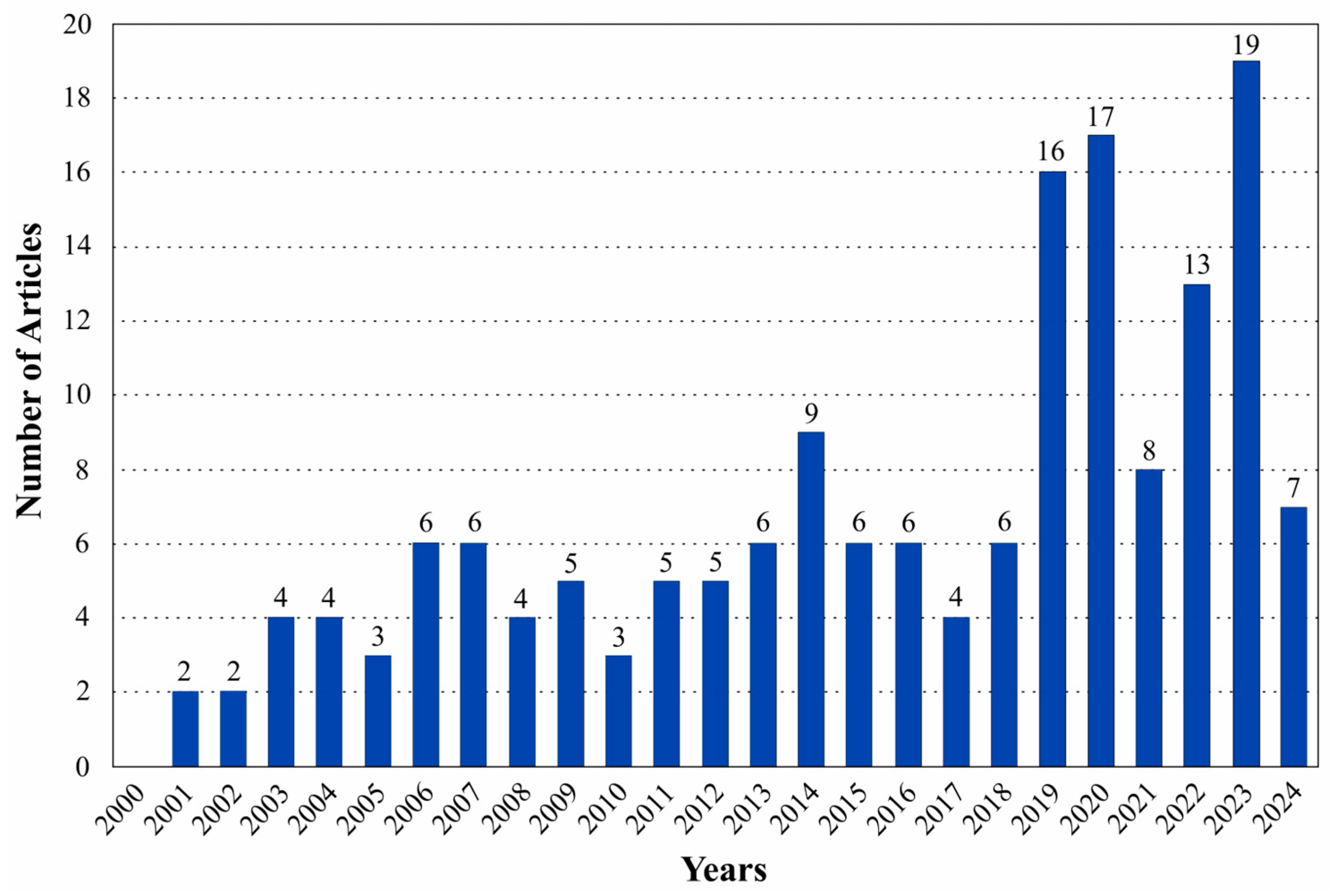
The number of publications with themes based on the numerical modeling of groundwater flow for the planning and management of water resources has increased significantly since 2019 (Figure 2). The trend in publications has increased from an average of six to an average of fourteen papers per year. No research articles with the specified keywords were found in 2000. The number of articles published between 2000 and 2005 was low, with less than four articles per year. The trend between 2006 and 2018 ranged from four to eight publications per year. The number of publications has significantly increased since 2019, with a maximum of 16 records for that year and reaching a peak of 19 records in 2023. As of February 2024, seven articles related to this field of research have been documented.

3.1.1. Published Journal

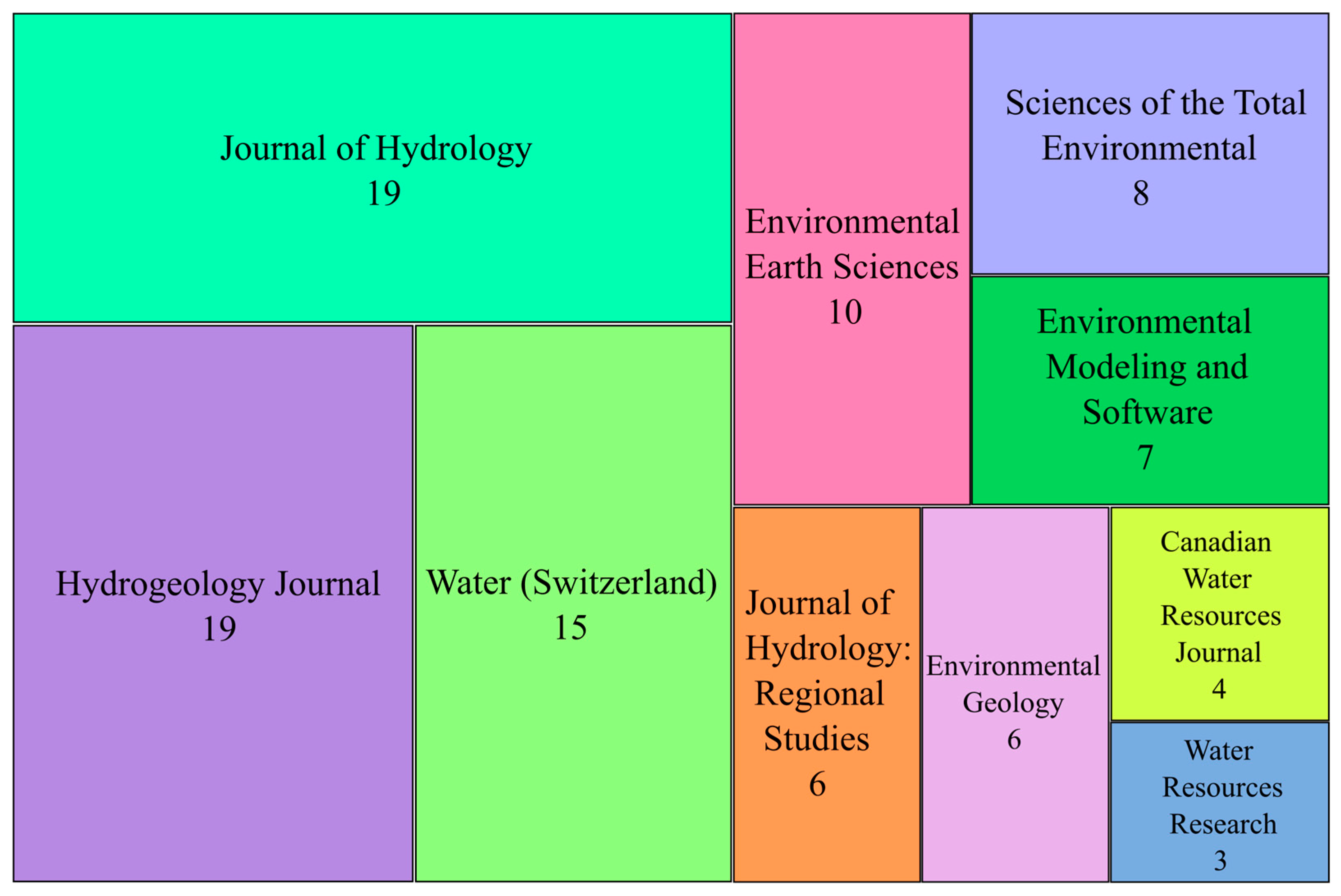
The SLR included scientific articles published in 62 different journals. Figure 3 shows the top 10 journals and the number of reviewed articles for each. Hydrogeology Journal and the Journal of Hydrology had the highest number of publications, with 19 articles each, followed by Water, Environmental Earth Sciences, and Sciences of the Total Environment with 15, 10, and 8 articles, respectively. The remaining five journals had fewer than eight articles.

3.1.2. Geographic Location

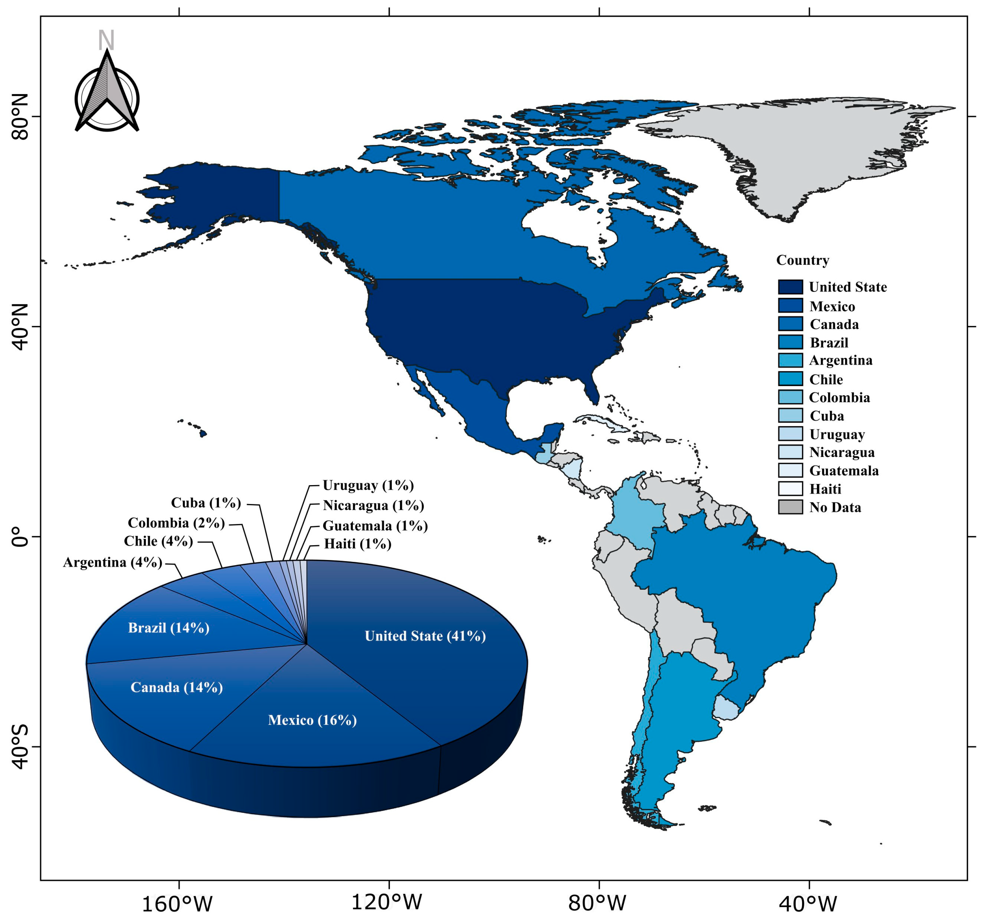
The study reviewed scientific articles collected from 12 countries. Figure 4 displays the geographical distribution of the articles by country. The United States (41%), Mexico (16%), and Canada (14%) have the highest percentage of publications. South American countries, such as Argentina (4%), Chile (4%), Colombia (2%), and Uruguay (1%), have less research compared to North American countries, with the exception of Brazil (14%). The Central American region has received little research attention. It accounts for only 4% of publications. Numerical modeling studies have been conducted in countries such as Nicaragua, Cuba, Guatemala, and Haiti [33,34,35]. However, this may change in the future, as water scarcity is already a critical issue in some regions due to climate change variations and an increase in water demand.

3.1.3. Co-Occurrence of Keywords

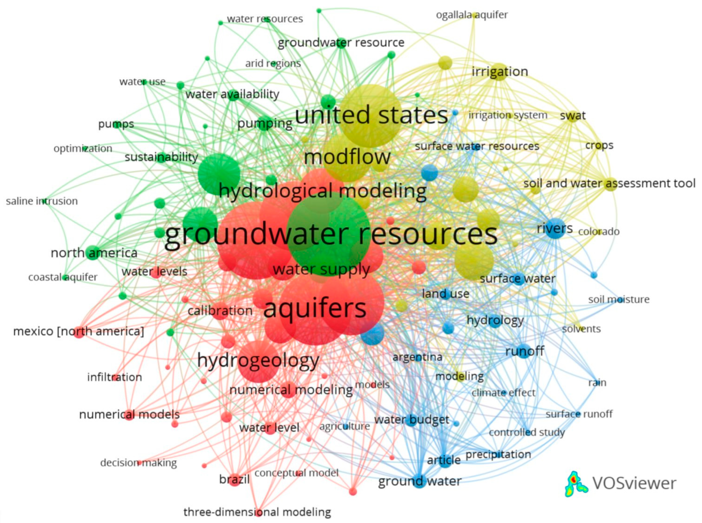
To evaluate the semantic structure of the research field, we performed a co-word/co-occurrence analysis using the author’s keywords instead of the automatically extracted ones because they are less specific and understandable than the keywords contributed by the authors [36,37,38]. We used VOSviewer software Vs. 1.6.20 to visualize the results, which are presented in Figure 5. To create this network, only keywords that appeared five or more times (110 out of 1469 keywords) were used. The size of each node in the network represents its frequency. The more important a word is, the larger its label and circle. In addition, the distance between nodes represents the strength of the relationship between keywords [39]. Applying this method revealed that the most frequently occurring keywords are groundwater resources (74), groundwater flow (67), aquifers (63), groundwater (60), aquifer (57), United States (54), MODFLOW (47), hydrological modeling (39), hydrogeology (38), and water management (35). The proximity of these keywords in the diagram suggests that the research topic primarily focuses on the hydrological modeling of groundwater resources. Furthermore, this analysis verified that this selection comprised pertinent articles containing keywords related to the research questions.

3.2. Groundwater Models

Currently, various codes and model software are available to study groundwater dynamics. The most commonly used numerical methods are the finite difference (FD) and finite element (FE) methods [40]. Table 2 shows examples of codes and software used in groundwater flow and transport modeling. The software and codes selected were exclusively focused on groundwater modeling, excluding integrated hydrological process software. ParFlow [41], HydroGeoSphere [42], MikeSHE [43], CATHY [44], and SWAT [45] are examples of integrated models that are widely reported in the scientific literature. Integrated models represent the entire land water cycle, incorporating key processes such as evapotranspiration, snow accumulation and melting, runoff, water routing at the surface and in the river channel, infiltration, groundwater flow, and groundwater discharge to surface reservoirs [46].
It is important to note that in this study, there is a vast dominance in the use of MODFLOW (saturated flow [47]) and FEFLOW (saturated and unsaturated flow [48]) software. Their use has been proven suitable for successfully simulating and predicting groundwater flow and transport conditions (in conjunction with other complementary codes) and groundwater–surface water interactions, from simple to complex problems: for example, modeling aquifers with sudden density changes, as occurs in coastal aquifers in Canada [49,50,51], the United States [52,53], Mexico [54,55], Brazil [56,57], and the salt flats of northern Chile [58,59].
The most commonly used software in this field of research is Visual MODFLOW [60], followed by MODELMUSE [61], GROUNDWATER Vistas (GV [62]), the Groundwater Modeling System (GMS [63,64]), and Processing Modflow for WinINdows (PMWIN [65]). Of these, PMWIN is the least utilized. These programs are based on finite difference and contain the MODFLOW code [47]. They are commonly used to simulate flow in a saturated medium. Finite element-based software, such as FEFLOW [48], HYDRUS [66], and GMS-FEMWATER [52], can model flow in both saturated and unsaturated media. These software types (FD and FE) are widely used for the numerical modeling of granular, fractured, karst, and coastal aquifers and for simulating solute transport in saturated and unsaturated media. The decision of which software to use is often not an easy one since it depends on the conceptual model of the aquifer, the modeling objectives, available data, available time to perform the study, model geometry (1D, 2D, and 3D dimensions), scale, complexity of the groundwater system, and local expertise. For example, many numerical groundwater models need more robust conceptual models of the aquifer rather than inaccurate numerical resolution [17,18].
This category also includes codes for simulating groundwater vulnerability, specifically solute transport. These codes are used in conjunction with groundwater flow models. Examples of widely reported numerical codes in the scientific literature include MODPATH [67] and MT3DMS [68], among many others reviewed by Machiwal et al. [69]. The SEAWAT [70], SWI2 [71], SUTRA [72], MODHMS [73], and FEMWATER [52] codes are commonly used to model saltwater intrusion in coastal aquifers and salt flats. These codes provide a comprehensive solution for jointly simulating flow and transport while accurately modeling groundwater flow under 3D conditions of varying density [74,75].
Table 2. Numerical groundwater codes/software [17,18,76,77].
Numerical MethodSoftwareCodes
Finite DifferenceMODELMUSE, VISUAL MODFLOW, GMS, GROUNDWATER VISTAS, SEAWAT, PMWIN, SUTRA, FLOWPATH II, TOUGH3, MARTHE.MODFLOW, FTWORK, HST2D/3D, INVFD, PLASM, HST3D, MICROFEM, MODFLOWT, MODPATH, MODTECH, MT3DMS, PATH3D, SWANFLOW, SWIFT, TARGET, TRACR3D, MODHMS-SURFACT, SWI2, BIOPLUMEIII, MOCDENS3D, FRACFLOW, HSSM, SWACROP, VIRTUS, VS2DT.
Finite ElementFEFLOW, GMS, SUTRA, NAPL Simulator, OpenGeoSys, AQÜIMPE, 3DFEMFAT, CODESA-3D, AQUA3D, SEEP/W, ChemFlux.ABCFEM, AQUIFEM-N, FEMWATER, MicroFEM, MODFE, MULAT, PTC, HYDRUS-2D/3D, TRANSIN, MOTRANS, SvFlux, SWICHA, IWFM, CANVAS, TRAFRAP-WT, FLONET/TR2, VS2DI/VS2TI, HYDRUS-1D, VAM2D, WinTran, SWICHA.

3.2.1. Model Calibration and Validation: Performance Metrics (PMs)

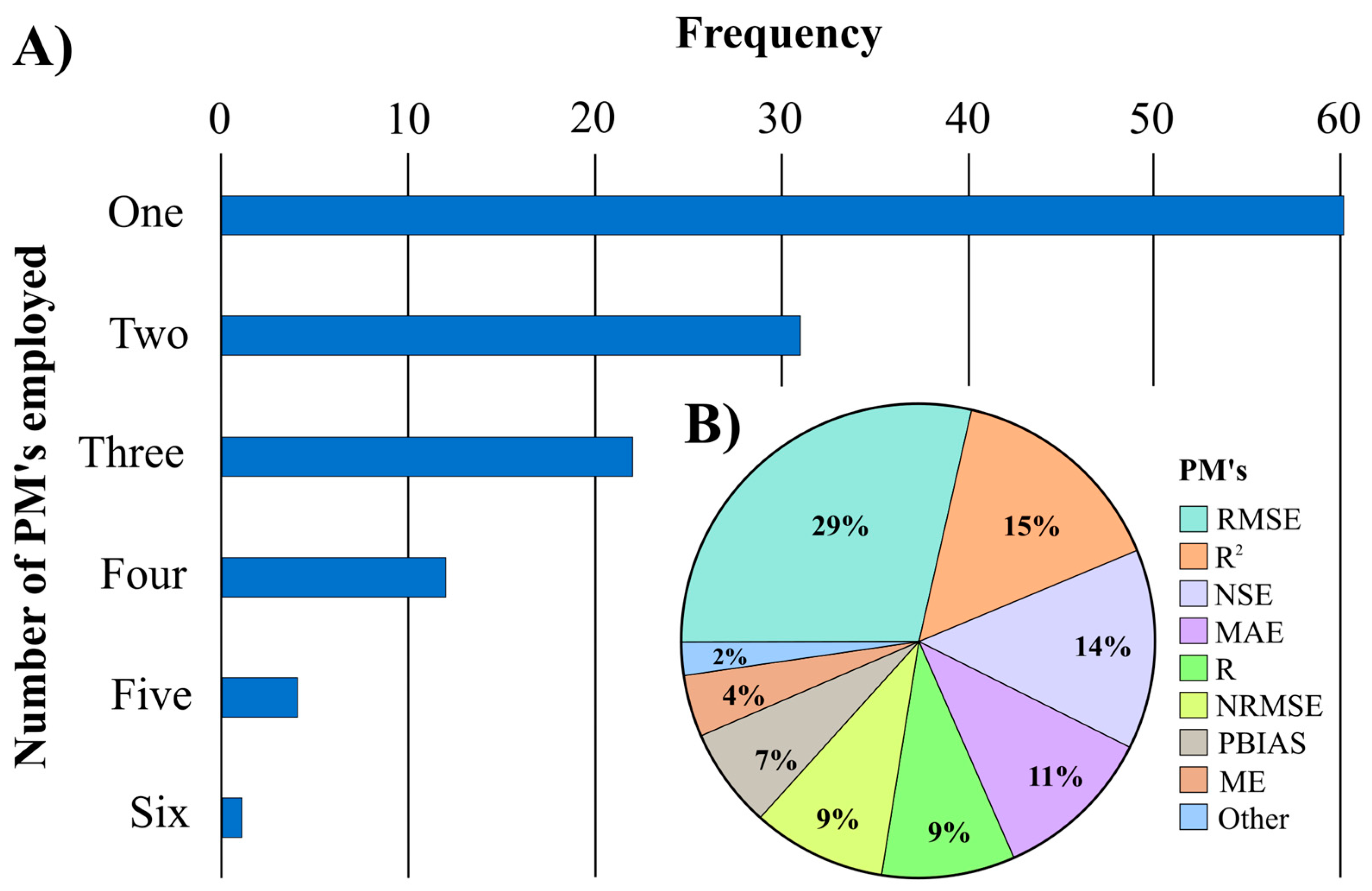
Performance metrics are essential statistical parameters for calibrating and validating hydrogeological models [78,79,80]. Calibration can be performed in steady state or transient conditions. Two criteria are used to evaluate calibration: manual calibration (trial-and-error calibration) and automatic calibration using inverse modeling algorithms, such as PEST (Parameter ESTimation Software [81]), SUIF-2 (Sequential Uncertainty Fitting [82]), HOB (Head Observation [83]), UCODE 2014 [84], and PSO (Particle Swarm Optimization [85]), among others. These software programs can be used for uncertainty analysis and sensitivity analysis. In the reviewed articles, manual calibration was the method most commonly used, and PEST software was the algorithm most frequently used for automatic calibration. Calibration success can be evaluated quantitatively or qualitatively by using performance metrics (PMs). Both assessments are necessary to assess the uncertainty of the numerical model performance [78,79]. The validation of the model performance is essential because most input variables or parameters, such as recharge input, hydraulic conductivity, specific yield coefficient, specific storage coefficient, and other model inputs, cannot be accurately measured [19,86,87]. Numerical models can provide appropriate information and be used as a decision-making tool to manage groundwater resources after proper validation [80]. Moriasi et al. [80] suggest that using multiple PM’s can improve the consistency and reliability of model performance. Figure 6A shows the number of PMs used to evaluate a model vs. frequency (number of occurrences). In contrast, Figure 6B displays the percentages of the most commonly used performance metrics for determining the best fit of numerical models. According to Moriasi et al. [80], the most frequently used statistical methods for evaluating numerical models are the RMSE (29%), R2 (15%), and NSE (14%). Other statistical metrics used include the MAE (11%), R (9%), NRMSE (9%), PBIAS (7%), and ME (4%). The “Other” category includes cumulative metrics with a frequency of ≤1%, such as the RSR, mNSE, KGE, or NOF. A total of 43% of the studies evaluated the performance of hydrogeological models using two or more metrics, while 37% used a single metric and the remaining 20% did not mention any performance metric.

3.2.2. Modeling at Different Scales: Study Unit

For groundwater management purposes, countries have divided their territory into basins and aquifers. Basins are defined by the area’s topography, while subsurface geological formations define aquifers. Basins and aquifers are the fundamental units for water resource planning and management [88,89]. Data are typically more accessible at these scales, where organizations contribute to knowledge acquisition and data availability [46]. Most of the research on numerical groundwater hydrogeological models developed in the last decade has been implemented at these scales. The hydrogeological units of study in the reviewed papers are shown in Figure 7. Most studies focused on modeling the aquifer as the target unit (Figure 7A). The types of aquifers conceptualized in the studies are unconfined aquifers (53%), confined aquifers (16%), semi-confined aquifers (14%), coastal aquifers (11%), and karst aquifers (6%) (Figure 7B). Over time, researchers have attempted to quantify groundwater resources at large spatial and temporal scales (regional, continental, or global scales), but this remains challenging due to the lack of in situ hydrogeological data and detailed descriptions of aquifer properties in many regions [6,7,90,91,92,93].
It is important to acknowledge that even with a well-calibrated and accurate numerical model, it will not provide a perfect representation of subsurface and hydrogeologic processes due to the inherent limitations of research tools. In practice, many models are simplified as they cannot fully reflect the heterogeneity and complexity of subsurface processes. The model’s success depends on its usage and scale, with the latter being critical to balancing the necessary complexity and level of detail. A local numerical model may require highly accurate data, while a regional one can achieve satisfactory results with slightly more significant average deviations. However, it is essential to remember that accuracy may decrease at a larger scale due to the need for more data, which can lead to errors, inconsistencies, and uncertainty [87,94,95].

3.2.3. Modeling Limitations: Data Collection

Numerical groundwater models are essential for planning and resource management [21,96,97]. However, constructing accurate models can be challenging due to the complex architecture of aquifer systems [1]. The software and hardware needed for modeling are widely available and advanced [21]. The problem lies in the availability and quality of data [1,2,21,98]. To accurately simulate the quantity and quality of groundwater resources, these models require a wide range of information, such as geology, geophysics, hydrogeology, hydrogeochemistry, hydrology, climatology, geography, and other supplementary data [40]. However, collecting such information, particularly in developing regions such as America, presents a challenge and suffers from high uncertainty [99,100,101]. Researchers in these countries face a lack of reliable, available, and measured long-term data; therefore, simplifications are often necessary [98]. These data’s limited availability and scarcity usually render inaccurate numerical models [1]. The lack of field data mainly causes uncertainties in groundwater modeling results and predictions, observation data errors, and conceptual model construction [19,21]. To model groundwater resources in a reliable context, it is necessary to perform detailed monitoring of the aquifer and integrate several hydrogeological data, extraction rates, and groundwater levels; quantify aquifer recharge; obtain the specific yield value; and assess water quality and seawater intrusion [21,55,99,100].
It is important to note that collecting detailed hydrogeological field observations can be expensive in large regions. In this context, geophysical surveys are a valuable data source for aquifer modeling. They offer a non-invasive, cost-effective approach to characterizing aquifer dimensions and stratigraphy. These surveys enhance geological understanding and hydrostratigraphic characterization, providing information on hydraulic properties, spatial extent, and flow directions [87,102]. In addition, remote sensing data can serve as a complementary alternative to provide information on several relevant hydrological variables [93,103]. For example, The Gravity Recovery and Climate Experiment (GRACE; [104]) and its successor, GRACE-FO, can estimate changes in groundwater storage by measuring variations in the gravity field. However, their spatial and temporal resolutions are only approximate [93]. Despite the fundamental spatial and temporal resolution of GRACE and GRACE-FO data, their high accuracy makes them particularly valuable for large-scale modeling, compensating for the limitations of observational data. However, further research is still needed to improve these data’s accuracy and spatial and temporal resolution, enabling their full exploitation [93,103,105].

3.3. Studied Regions: Challenges and Future Research

3.3.1. Studied Regions

Many regions studied are located in arid and semi-arid zones, including western and central Canada and the United States, northwestern, northern, and central Mexico, and western South America. These regions face significant challenges in groundwater management due to overexploitation and contamination resulting from increased water demand. Climate change and population growth are the primary factors putting pressure on groundwater resources, worsening these issues.
The overexploitation of groundwater for anthropogenic supply leads to significant declines in groundwater levels and is a continuous concern in these American countries. The increase in water demand is mainly due to population growth, industrial activity, agricultural needs, and the impact of climate change, in addition to inefficient water management and competition among economic sectors for its consumption. It is important to note that these regions were facing difficulties with groundwater sustainability even before the threat of climate change was identified [106,107,108,109]. In these regions, groundwater sustainability faces other significant threats, such as groundwater quality degradation due to contamination by natural and anthropogenic sources. The contamination of aquifer systems is frequent in coastal areas due to seawater intrusion and groundwater salinization due to aquifer overexploitation and through the recharge of polluted surface water into aquifers [51,110]. Researchers have shown great interest in water resource management in coastal areas. However, understanding the groundwater dynamics of coastal aquifers remains a significant challenge [111]. In recent years, there has been an increase in these concerns, highlighting the importance of describing and understanding the behavior of aquifer systems. Planning and evaluating water management strategies to address these emerging challenges is crucial. It is also essential to develop numerical models covering unexplored regions as stakeholders and water managers dictate.
Transboundary numerical groundwater modeling is principally assessed in basins located between Canada, the USA, and Mexico in North America and between Brazil, Argentina, Paraguay, and Uruguay in South America [90,112,113,114,115]. Despite this trend, numerical models have not been implemented for planning and managing shared groundwater resources on the southern border between Mexico, Guatemala, and Belize [99].
Despite the undeniable trend in groundwater degradation, aquifer overexploitation, and vulnerability to climate change in the central region of the American continent, more scientific attention needs to be paid to developing numerical groundwater modeling. The lack of research in this area can be attributed to various factors, including the apparent abundance of groundwater resources, limited regional research funding, and a lack of political and/or scientific interest [9,99]. However, the implementation of numerical models could be highly beneficial; these models can help to analyze and solve critical issues such as floods or droughts in vulnerable communities, assess water availability, monitor water quality degradation, and develop equitable water allocation systems among users and countries [9,99,116].
The numerical models used in these regions have significantly contributed to our understanding of complex aquifer systems; they assess current and alternative groundwater management strategies, predict the impacts of climate change, pollution, and increased pumping on aquifer behavior, and mitigate its adverse effects. Additionally, these models have highlighted the limitations, uncertainties, and data gaps in this research field. It is important to remark that while these models provide an approximate representation of natural aquifer systems, they do not directly solve water management problems. However, they can provide valuable information to support planning and decision making for sound groundwater resource management. It is essential to address these vulnerabilities and promote social resilience building. Despite the challenges and limitations, researchers are encouraged to continue developing and refining numerical groundwater models in these regions. These studies will expand their spatial scope and improve our knowledge and understanding of potential future effects on aquifers.

3.3.2. Evaluating and Forecasting Future Scenarios

Numerical models enable the simulation of groundwater flow in the aquifer under different conditions and predictive scenarios, facilitating the visualization of its behavior in the short, medium, and long term. Scenario simulation is crucial for groundwater management. Each scenario is designed to address the region’s specific issues and is implemented over a defined period. During this period, parameters that primarily affect groundwater recharge and storage, such as population growth and climate change, are modified [98]. Fifty-one percent of the reviewed studies performed scenario simulations to predict future outcomes. Simulations estimated the effects of changes in groundwater extraction based on different population growth projections and groundwater demand (urban, agricultural, and industrial use) on extraction and recharge scenarios (30%). However, only 16% of published studies have examined the impacts of climate change on groundwater resources based on predictive scenarios, and just 5% have focused on pollution.
Furthermore, 35% of studies did not consider climate change’s impact on numerical models. This omission could be reducing the effectiveness of the studies. Previous studies have reported significant effects on groundwater resources attributed to climate change [98]. Researchers have described significant impacts of climate change on water resources including variability in precipitation and groundwater recharge, changes in water demand, sea level rise, altered evapotranspiration, etc. [6,93,117]. Without accounting for climate change, models may result in underestimating or misinterpreting future risks associated with groundwater availability [98]. Therefore, future studies should consider the effects of climate change on groundwater management and perform long-term transient state simulations to assess the impact of temporal variability and aquifer storage potential [21]. Predictions based on climatic trends are vital for accurate modeling and effective water resource management. Additionally, it is essential to evaluate other anthropogenic pressures, such as land use alterations, pollution, and increasing pumping rates for irrigation, drinking water, or industrial purposes [21,46].
Numerical models have the potential to be decisive tools for proactive decision making. However, their practical application has so far been mostly restricted to steady state scenarios that ignore aquifer storage potential [21]. In the future, these models will be essential for optimizing groundwater resource management and meeting these challenges. However, to achieve this goal, it is crucial that the models operate in a transient mode that fully incorporates time variations in system inputs and outputs. This will require a significant amount of data. The main obstacle to addressing groundwater challenges is insufficient field data to feed predictive models [21,46,99].

4. Conclusions

This work summarized the current state of numerical groundwater flow models used to evaluate water resource management in America from 2000 to 2024. Research studies from the Scopus and Web of Science databases were collected and reviewed. Visual MODFLOW, MODELMUSE, GMS, GV, and FEFLOW are the most commonly used software for visual numerical groundwater simulation. In practice, they have proven to be practical modeling tools that provide valuable information for developing adaptation and mitigation strategies to face future challenges such as climate change, increased water demand due to population growth, and agricultural and industrial development. Additionally, scenario simulation and the assessment of aquifer system responses should be included in future activities. Simulating the combined effects of climate change and other pressures is important. The root mean square error (RMSE) was the most commonly used performance metric for model calibration and validation. These models were primarily developed in arid and semi-arid regions, where groundwater management challenges are most significant. Numerical models have significantly contributed to understanding aquifer systems and have successfully supported water management processes. However, numerical modeling faces numerous challenges and limitations. The availability of data to construct or validate conceptual models often needs to be improved. In addition to the scarcity of studies and data in some areas, climate change challenges groundwater sustainability. This phenomenon will particularly affect arid and semi-arid regions, making them a priority for future research. The continued research, improvement, and development of numerical groundwater models are essential to ensure the sustainability of groundwater resources.

Supplementary Materials

The following supporting information can be downloaded at https://www.mdpi.com/article/10.3390/hydrology11110179/s1. Supplementary S1: full-text eligibility checklist; Supplementary S2: full list of the articles included in the review.

Author Contributions

Conceptualization, A.E.M.C. and D.A.M.C.; methodology, B.L.L.H. and A.E.M.C.; writing—original draft preparation, B.L.L.H., A.E.M.C. and D.A.M.C.; writing—review and editing, A.E.M.C., D.A.M.C., J.A.R.L., E.H.P., J.G.P. and O.G.A.T. All authors have read and agreed to the published version of the manuscript.

Funding

This research did not receive any grants from public, commercial, or non-profit sectors.

Data Availability Statement

Data will be made available on request.

Acknowledgments

Thanks to the Consejo Nacional de Humanidades, Ciencias y Tecnologías (CONAHCYT) for awarding a Ph.D. scholarship (No. 995248) and the Instituto Potosino de Investigación Científica y Tecnológica A.C. (IPICYT).

Conflicts of Interest

The authors declare no conflicts of interest.

References

  1. Ricka, A.; Kuchovsky, T.; Damdindorj, B.; Fürych, V.; Kopriva, A.; Puntsag, K. Identifying the Flow Pattern and Natural Recharge at a Strategic Groundwater Resource in the Dornogobi Province, Mongolia. Hydrol. Sci. J. 2018, 63, 1408–1423. [Google Scholar] [CrossRef]
  2. Taye, M.T.; Ebrahim, G.Y.; Nigussie, L.; Hagos, F.; Uhlenbrook, S.; Schmitter, P. Integrated Water Availability Modelling to Assess Sustainable Agricultural Intensification Options in the Meki Catchment, Central Rift Valley, Ethiopia. Hydrol. Sci. J. 2022, 67, 2271–2293. [Google Scholar] [CrossRef]
  3. Nasri, N.; Souissi, F.; Ben Attia, T.; Ismailia, A.; Smida, O.; Tangour, D.; López Maldonado, E.A.; Souissi, R. Hydro Geochemical Characteristics and Mineralization Process of Groundwater in the Phosphatic Basin of Gafsa, Southwestern Tunisia. Hydrology 2024, 11, 142. [Google Scholar] [CrossRef]
  4. Rajeevan, U.; Mishra, B.K. Sustainable Management of the Groundwater Resource of Jaffna, Sri Lanka with the Participation of Households: Insights from a Study on Household Water Consumption and Management. Groundw. Sustain. Dev. 2020, 10, 100280. [Google Scholar] [CrossRef]
  5. Davamani, V.; John, J.E.; Poornachandhra, C.; Gopalakrishnan, B.; Arulmani, S.; Parameswari, E.; Santhosh, A.; Srinivasulu, A.; Lal, A.; Naidu, R. A Critical Review of Climate Change Impacts on Groundwater Resources: A Focus on the Current Status, Future Possibilities, and Role of Simulation Models. Atmosphere 2024, 15, 122. [Google Scholar] [CrossRef]
  6. Wada, Y.; De Graaf, I.E.M.; Van Beek, L.P.H. High-Resolution Modeling of Human and Climate Impacts on Global Water Resources. J. Adv. Model. Earth Syst. 2016, 8, 735–763. [Google Scholar] [CrossRef]
  7. De Graaf, I.E.M.; Sutanudjaja, E.H.; Van Beek, L.P.H.; Bierkens, M.F.P. A High-Resolution Global-Scale Groundwater Model. Hydrol. Earth Syst. Sci. 2015, 19, 823–837. [Google Scholar] [CrossRef]
  8. Boretti, A.; Rosa, L. Reassessing the Projections of the World Water Development Report. Npj Clean Water 2019, 2, 15. [Google Scholar] [CrossRef]
  9. Jiménez-Cisneros, B.; Galizia-Tundisi, J. Diagnosis of Water in the Americas; Academia Mexicana de Ciencias: Mexico City, Mexico, 2013. [Google Scholar]
  10. Rodríguez, C.; García, B.; Pinto, C.; Sánchez, R.; Serrano, J.; Leiva, E. Water Context in Latin America and the Caribbean: Distribution, Regulations and Prospects for Water Reuse and Reclamation. Water 2022, 14, 3589. [Google Scholar] [CrossRef]
  11. Rojas Scheffer, V. Review: Application of Hydrogeological Models Coupled with Agent-Based Models to Address Sustainable Groundwater Management in Latin America. Hydrogeol. J. 2024, 32, 935–949. [Google Scholar] [CrossRef]
  12. Rama, F.; Busico, G.; Arumi, J.L.; Kazakis, N.; Colombani, N.; Marfella, L.; Hirata, R.; Kruse, E.E.; Sweeney, P.; Mastrocicco, M. Assessment of Intrinsic Aquifer Vulnerability at Continental Scale through a Critical Application of the Drastic Framework: The Case of South America. Sci. Total Environ. 2022, 823, 153748. [Google Scholar] [CrossRef] [PubMed]
  13. Naeem, K.; Zghibi, A.; Elomri, A.; Mazzoni, A.; Triki, C. A Literature Review on System Dynamics Modeling for Sustainable Management of Water Supply and Demand. Sustainability 2023, 15, 6826. [Google Scholar] [CrossRef]
  14. Faquseh, H.; Shadeed, S.; Grossi, G. Impacts of Climate Change on Groundwater in the Al-Badan Sub-Catchment, Palestine: Analyzing Historical Data and Future Scenarios. Hydrology 2024, 11, 169. [Google Scholar] [CrossRef]
  15. Uc Castillo, J.L.; Martínez Cruz, D.A.; Ramos Leal, J.A.; Tuxpan Vargas, J.; Rodríguez Tapia, S.A.; Marín Celestino, A.E. Delineation of Groundwater Potential Zones (GWPZs) in a Semi-Arid Basin through Remote Sensing, GIS, and AHP Approaches. Water 2022, 14, 2138. [Google Scholar] [CrossRef]
  16. Ahmadi, A.; Olyaei, M.; Heydari, Z.; Emami, M.; Zeynolabedin, A.; Ghomlaghi, A.; Daccache, A.; Fogg, G.E.; Sadegh, M. Groundwater Level Modeling with Machine Learning: A Systematic Review and Meta-Analysis. Water 2022, 14, 949. [Google Scholar] [CrossRef]
  17. Kumar, C.P.; Singh, S. Concepts and Modeling of Groundwater System. Int. J. Innov. Sci. Eng. Technol. 2015, 2, 262–271. [Google Scholar]
  18. Kumar, C.P. An Overview of Commonly Used Groundwater Modelling Software. Int. J. Adv. Sci. Eng. Technol. 2019, 6, 7854–7865. [Google Scholar]
  19. Ehtiat, M.; Mousavi, S.J.; Vaghefi, S.A.; Ghaheri, A. Analysis of Recharge Conceptualization in Inverse Groundwater Modelling. Hydrol. Sci. J. 2016, 61, 2789–2801. [Google Scholar] [CrossRef]
  20. Norouzi Khatiri, K.; Nematollahi, B.; Hafeziyeh, S.; Niksokhan, M.H.; Nikoo, M.R.; Al-Rawas, G. Groundwater Management and Allocation Models: A Review. Water 2023, 15, 253. [Google Scholar] [CrossRef]
  21. Howard, K.E.N.; Griffith, A. Can the Impacts of Climate Change on Groundwater Resources Be Studied without the Use of Transient Models? Hydrol. Sci. J. 2009, 54, 754–764. [Google Scholar] [CrossRef]
  22. El Alfy, M. Numerical Groundwater Modelling as an Effective Tool for Management of Water Resources in Arid Areas. Hydrol. Sci. J. 2014, 59, 1259–1274. [Google Scholar] [CrossRef]
  23. Zhou, Y.; Li, W. A Review of Regional Groundwater Flow Modeling. Geosci. Front. 2011, 2, 205–214. [Google Scholar] [CrossRef]
  24. Sikdar, P.K. Groundwater Development and Management: Issues and Challenges in South Asia; Springer International Publishing: Cham, Switzerland, 2019. [Google Scholar]
  25. De León Pérez, D.; Acosta Vega, R.; Salazar Galán, S.; Aranda, J.Á.; Francés García, F. Toward Systematic Literature Reviews in Hydrological Sciences. Water 2024, 16, 436. [Google Scholar] [CrossRef]
  26. Nguyen, N.; Singh, S. A Primer on Systematic Reviews and Meta-Analyses. Semin. Liver Dis. 2018, 38, 103–111. [Google Scholar] [CrossRef]
  27. Kitchenham, B. Procedures for Performing Systematic Reviews; Keele University: Keele, UK, 2004; Volume 33. [Google Scholar]
  28. Muka, T.; Glisic, M.; Milic, J.; Verhoog, S.; Bohlius, J.; Bramer, W.; Chowdhury, R.; Franco, O.H. A 24-Step Guide on How to Design, Conduct, and Successfully Publish a Systematic Review and Meta-Analysis in Medical Research. Eur. J. Epidemiol. 2020, 35, 49–60. [Google Scholar] [CrossRef]
  29. White, H.; Waddington, H. Why Do We Care about Evidence Synthesis? An Introduction to the Special Issue on Systematic Reviews. J. Dev. Eff. 2012, 4, 351–358. [Google Scholar] [CrossRef]
  30. Siddaway, A.P.; Wood, A.M.; Hedges, L.V. How to Do a Systematic Review: A Best Practice Guide for Conducting and Reporting Narrative Reviews, Meta-Analyses, and Meta-Syntheses. Annu. Rev. Psychol. 2019, 70, 747–770. [Google Scholar] [CrossRef]
  31. Donthu, N.; Kumar, S.; Mukherjee, D.; Pandey, N.; Lim, W.M. How to Conduct a Bibliometric Analysis: An Overview and Guidelines. J. Bus. Res. 2021, 133, 285–296. [Google Scholar] [CrossRef]
  32. Chadegani, A.A.; Salehi, H.; Yunus, M.M.; Farhadi, H.; Fooladi, M.; Farhadi, M.; Ebrahim, N.A. A Comparison between Two Main Academic Literature Collections: Web of Science and Scopus Databases. Asian Soc. Sci. 2013, 9, p18. [Google Scholar] [CrossRef]
  33. Calderón Palma, H.; Bentley, L.R. A Regional-Scale Groundwater Flow Model for the Leon-Chinandega Aquifer, Nicaragua. Hydrogeol. J. 2007, 15, 1457–1472. [Google Scholar] [CrossRef]
  34. Gárfias, J.; Expósito, J.L. Delimitación de las zonas de protección mediante métodos analíticos y un modelo numérico de agua subterránea, acuífero Margarita, Cuba. Boletín Geológico Min. 2008, 119, 7–20. [Google Scholar]
  35. Arnaud, L.; Gutierrez, A.; Zegoulli, I.; Gonomy, N. Modelling Groundwater Flow in the Plaine Du Nord–Massacre Shallow Aquifer, Haiti. Hydrogeol. J. 2022, 30, 1399–1415. [Google Scholar] [CrossRef]
  36. Zhang, J.; Yu, Q.; Zheng, F.; Long, C.; Lu, Z.; Duan, Z. Comparing Keywords plus of WOS and Author Keywords: A Case Study of Patient Adherence Research. Assoc. Inf. Sci. Technol. 2016, 67, 967–972. [Google Scholar] [CrossRef]
  37. Zhang, W.; Zhang, Q.; Yu, B.; Zhao, L. Knowledge Map of Creativity Research Based on Keywords Network and Co-Word Analysis, 1992–2011. Qual. Quant. 2015, 49, 1023–1038. [Google Scholar] [CrossRef]
  38. Galvez, C. Análisis de co-palabras aplicado a los artículos muy citados en Biblioteconomía y Ciencias de la Información (2007–2017). Transinformação 2018, 30, 277–286. [Google Scholar] [CrossRef]
  39. Van Eck, N.J.; Waltman, L. Software Survey: VOSviewer, a Computer Program for Bibliometric Mapping. Scientometrics 2010, 84, 523–538. [Google Scholar] [CrossRef]
  40. Anderson, M.P.; Woessner, W.W.; Hunt, R.J. Applied Groundwater Modeling: Simulation of Flow and Advective Transport, 2nd ed.; Academic Press: London, UK; San Diego, CA, USA, 2015. [Google Scholar]
  41. Kollet, S.J.; Maxwell, R.M. Integrated Surface–Groundwater Flow Modeling: A Free-Surface Overland Flow Boundary Condition in a Parallel Groundwater Flow Model. Adv. Water Resour. 2006, 29, 945–958. [Google Scholar] [CrossRef]
  42. Therrien, R.; McLaren, R.G.; Sudicky, E.A.; Panday, S.M. HydroGeoSphere: A Three-Dimensional Numerical Model Describing Fully-Integrated Subsurface and Surface Flow and Solute Transport; Groundwater Simulations Group, University of Waterloo: Waterloo, ON, Canada, 2010; p. 830. [Google Scholar]
  43. DHI Software. MIKE SHE User Manual; DHI Software: Hørsholm, Danemark, 2007; Volume 2. [Google Scholar]
  44. Guay, C.; Nastev, M.; Paniconi, C.; Sulis, M. Comparison of Two Modeling Approaches for Groundwater–Surface Water Interactions. Hydrol. Process. 2013, 27, 2258–2270. [Google Scholar] [CrossRef]
  45. Arnold, J.G.; Moriasi, D.N.; Gassman, P.W.; Abbaspour, K.C.; White, M.J.; Srinivasan, R.; Santhi, C.; Harmel, R.D.; Van Griensven, A.; Van Liew, M.W.; et al. SWAT: Model Use, Calibration, and Validation. Trans. ASABE 2012, 55, 1491–1508. [Google Scholar] [CrossRef]
  46. Larocque, M.; Levison, J.; Martin, A.; Chaumont, D. A Review of Simulated Climate Change Impacts on Groundwater Resources in Eastern Canada. Can. Water Resour. J. Rev. Can. Ressour. Hydr. 2019, 44, 22–41. [Google Scholar] [CrossRef]
  47. Harbaugh, A.W. MODFLOW-2005, The U.S. Geological Survey Modular Ground-Water Model—The Ground-Water Flow Process. In U.S. Geological Survey. USGS Editor. Techniques and Methods; US Department of the Interior, US Geological Survey: Reston, VA, USA, 2005; 253p. [Google Scholar]
  48. Diersch, H.-J.G. FEFLOW: Finite Element Modeling of Flow, Mass and Heat Transport in Porous and Fractured Media; Springer: Berlin/Heidelberg, Germany, 2014. [Google Scholar]
  49. Green, N.R.; MacQuarrie, K.T.B. An Evaluation of the Relative Importance of the Effects of Climate Change and Groundwater Extraction on Seawater Intrusion in Coastal Aquifers in Atlantic Canada. Hydrogeol. J. 2014, 22, 609–623. [Google Scholar] [CrossRef]
  50. Paradis, D.; Vigneault, H.; Lefebvre, R.; Savard, M.M.; Ballard, J.-M.; Qian, B. Groundwater Nitrate Concentration Evolution under Climate Change and Agricultural Adaptation Scenarios: Prince Edward Island, Canada. Earth Syst. Dyn. 2016, 7, 183–202. [Google Scholar] [CrossRef]
  51. Coulon, C.; White, J.T.; Pryet, A.; Gatel, L.; Lemieux, J.-M. An Ensemble-Based Approach for Pumping Optimization in an Island Aquifer Considering Parameter, Observation and Climate Uncertainty. Hydrol. Earth Syst. Sci. 2024, 28, 303–319. [Google Scholar] [CrossRef]
  52. Lin, J.; Snodsmith, J.B.; Zheng, C.; Wu, J. A Modeling Study of Seawater Intrusion in Alabama Gulf Coast, USA. Environ. Geol. 2009, 57, 119–130. [Google Scholar] [CrossRef]
  53. Bittner, L.; England, S.; Murray, C.; Mirecki, J.; Richardson, E.; Brown, C.; Kaiman, B. Development of a New Model Tool for Evaluating Groundwater Resources within the Floridan Aquifer System in Southern Florida, USA. Environ. Earth Sci. 2017, 76, 718. [Google Scholar] [CrossRef]
  54. Trasviña-Carrillo, J.A.; Wurl, J.; Imaz-Lamadrid, M.A. Groundwater Flow Model and Statistical Comparisons Used in Sustainability of Aquifers in Arid Regions. Resources 2019, 8, 134. [Google Scholar] [CrossRef]
  55. Wurl, J.; Gámez, A.E.; Ivanova, A.; Imaz Lamadrid, M.A.; Hernández-Morales, P. Socio-Hydrological Resilience of an Arid Aquifer System, Subject to Changing Climate and Inadequate Agricultural Management: A Case Study from the Valley of Santo Domingo, Mexico. J. Hydrol. 2018, 559, 486–498. [Google Scholar] [CrossRef]
  56. Rama, F.; Miotliński, K. Multiple-Step Numerical Modeling to Assist Aquifer Characterization: A Case Study from the South of Brazil. Hydrogeol. J. 2020, 28, 2747–2763. [Google Scholar] [CrossRef]
  57. Bofill, L.M.; Suhogusoff, A.V.; Ferrari, L.; Roisenberg, A. Analysis and Comparison of Wellhead Protection Areas Delimitation Methods Applying a Stochastic MODFLOW Model as a Reference. Environ. Monit. Assess. 2023, 195, 704. [Google Scholar] [CrossRef]
  58. Marazuela, M.A.; Vázquez-Suñé, E.; Ayora, C.; García-Gil, A.; Palma, T. The Effect of Brine Pumping on the Natural Hydrodynamics of the Salar de Atacama: The Damping Capacity of Salt Flats. Sci. Total Environ. 2019, 654, 1118–1131. [Google Scholar] [CrossRef]
  59. Narvaez-Montoya, C.; Torres-Martínez, J.A.; Pino-Vargas, E.; Cabrera-Olivera, F.; Loge, F.J.; Mahlknecht, J. Predicting Adverse Scenarios for a Transboundary Coastal Aquifer System in the Atacama Desert (Peru/Chile). Sci. Total Environ. 2022, 806, 150386. [Google Scholar] [CrossRef] [PubMed]
  60. Waterloo Hydrogeologic Inc. Visual MODFLOW; Waterloo Hydrogeologic Inc.: Waterloo, ON, Canada, 2022. [Google Scholar]
  61. Winston, R.B. ModelMuse—A Graphical User Interface for MODFLOW–2005 and PHAST. In U.S. Geological Survey Techniques and Methods; US Geological Survey: Reston, VA, USA, 2009; p. 52. [Google Scholar]
  62. Environmental Simulations Incorporated. Guide to Using Groundwater Vistas; Environmental Simulations Incorporated: Leesport, PA, USA, 2015. [Google Scholar]
  63. Aquaveo. GMS 10.1 Tutorial: MODFLOW—Stochastic Modeling; Indicator Simulations; Aquaveo: Provo, UT, USA, 2016. [Google Scholar]
  64. Aquaveo. Software GMS 10.0 Groundwater Modeling System. 2014. Available online: https://www.aquaveo.com/announcements (accessed on 10 June 2024).
  65. Chiang, W.-H.; Kinzelbach, W. 3D-Groundwater Modeling with PMWIN: A Simulation System for Modeling Groundwater Flow and Transport Processes, 2nd ed.; Springer: Berlin/Heidelberg, Germany; New York, NY, USA, 2005. [Google Scholar]
  66. Šejna, M.; Šimůnek, J.; van Genuchten, M.T. The HYDRUS Software Package for Simulating Two- and Three-Dimensional Movement of Water, Heat, and Multiple Solutes in Variably-Saturated Media, Version 3.01; User Manual; PC Progress: Prague, Czech Republic, 2018. [Google Scholar]
  67. Pollock, D.W. User’s Guide for MODPATH/MODPATH-PLOT, Version 3: A Particle Tracking Post-Processing Package for MODFLOW the U.S. Geological Survey Finite-Difference Ground-Water Flow Model; U.S. Geological Survey: Reston, VA, USA, 1994; pp. 94–464.
  68. Bedekar, V.; Morway, E.D.; Langevin, C.D.; Tonkin, M. MT3D-USGS Version 1: A U.S. Geological Survey Release of MT3DMS Updated with New and Expanded Transport Capabilities for Use with MODFLOW. In U.S. Geological Survey Techniques and Methods; U.S. Geological Survey: Reston, VA, USA, 2016; p. 69. [Google Scholar]
  69. Machiwal, D.; Jha, M.K.; Singh, V.P.; Mohan, C. Assessment and Mapping of Groundwater Vulnerability to Pollution: Current Status and Challenges. Earth Sci. Rev. 2018, 185, 901–927. [Google Scholar] [CrossRef]
  70. Langevin, C.D. SEAWAT: A Computer Program for Simulation of Variable-Density Groundwater Flow and Multi-Species Solute and Heat Transport; US Geological Survey: Reston, VA, USA, 2009.
  71. Bakker, M.; Schaars, F.; Hughes, J.D.; Langevin, C.D.; Dausman, A.M. Documentation of the Seawater Intrusion (SWI2) Package for MODFLOW. In U.S. Geological Survey Techniques and Methods; US Geological Survey: Reston, VA, USA, 2013; p. 47. [Google Scholar]
  72. Voss, C.I.; Provost, A.M. SUTRA, a Model for Saturated-Unsaturated, Variable-Density Groundwater Flow with Solute or Energy Transport—Documentation of Generalized Boundary Conditions, a Modified Implementation of Specified Pressures and Concentrations or Temperatures, and the Lake Capability. In U.S. Geological Survey Techniques and Methods; US Geological Survey: Reston, VA, USA, 2019; p. 62. [Google Scholar]
  73. HydroGeoLogic Inc. MODHMS—MODFLOW-Based Hydrologic Modeling System: Documentation and User’s Guide; HydroGeoLogic Inc.: Herndon, VA, USA, 2002. [Google Scholar]
  74. Bear, J.; Cheng, A.H.-D.; Sorek, S.; Ouazar, D.; Herrera, I. Seawater Intrusion in Coastal Aquifers—Concepts, Methods and Practices; Theory and Applications of Transport in Porous Media; Springer: Dordrecht, The Netherlands, 1999; Volume 14. [Google Scholar]
  75. Langevin, C.D.; Oude Essink, G.H.P.; Panday, S.; Bakker, M.; Prommer, H.; Swain, E.D.; Jones, W.; Beach, M.; Barcelo, M. MODFLOW-Based Tools for Simulation of Variable-Density Groundwater FLow. In Coastal Aquifer Management: Monitoring, Modeling, and Case Studies; Cheng, A., Ouazar, D., Eds.; Lewis Publishers: Boca Raton, FL, USA, 2004; pp. 49–76. [Google Scholar]
  76. Yang, X.; Steward, D.R.; De Lange, W.J.; Lauwo, S.Y.; Chubb, R.M.; Bernard, E.A. Data Model for System Conceptualization in Groundwater Studies. Int. J. Geogr. Inf. Sci. 2010, 24, 677–694. [Google Scholar] [CrossRef]
  77. Kumar, C.P. Groundwater flow models. Int. J. Mod. Sci. Eng. Technol. 2015, 2, 18–27. [Google Scholar]
  78. Coffey, M.E.; Workman, S.R.; Taraba, J.L.; Fogle, A.W. Statistical procedures for evaluating daily and monthly hydrologic model predictions. Trans. ASAE 2004, 47, 59–68. [Google Scholar] [CrossRef]
  79. Moriasi, D.N.; Arnold, J.G.; Van Liew, M.W.; Bingner, R.L.; Harmel, R.D.; Veith, T.L. Model Evaluation Guidelines for Systematic Quantification of Accuracy in Watershed Simulations. Trans. ASABE 2007, 50, 885–900. [Google Scholar] [CrossRef]
  80. Moriasi, D.N.; Gitau, M.W.; Pai, N.; Daggupati, P. Hydrologic and Water Quality Models: Performance Measures and Evaluation Criteria. Trans. ASABE 2015, 58, 1763–1785. [Google Scholar] [CrossRef]
  81. Doherty, J. PEST: Model-Independent Parameter Estimation, User Manual, 5th ed.; With Slight Additions, Watermark Numerical Computing: Brisbane, Australia, 2010. [Google Scholar]
  82. Abbaspour, K.C. SWAT-CUP: SWAT Calibration and Uncertainty Programs—A User Manual, Department of Systems Analysis, Integrated Assessment and Modelling (SIAM), EAWAG; Swiss Federal Institute of Aqualtic Science and Technology: Duebendorf, Switzerland, 2015. [Google Scholar]
  83. Bushira, K.M.; Hernandez, J.R.; Sheng, Z. Surface and Groundwater Flow Modeling for Calibrating Steady State Using MODFLOW in Colorado River Delta, Baja California, Mexico. Model. Earth Syst. Environ. 2017, 3, 815–824. [Google Scholar] [CrossRef]
  84. Poeter, E.P.; Hill, M.C.; Lu, D.; Tiedeman, C.; Mehl, S.W. UCODE_2014, with New Capabilities to Define Parameters Unique to Predictions, Calculate Weights Using Simulated Values, Estimate Parameters with SVD, Evaluate Uncertainty with MCMC, and More (Technical Report); Integrated Groundwater Modeling Center (IGWMC) of the Colorado School of Mines: Golden, CO, USA, 2014. [Google Scholar]
  85. Rafiei, V.; Nejadhashemi, A.P.; Mushtaq, S.; Bailey, R.T.; An-Vo, D.-A. An Improved Calibration Technique to Address High Dimensionality and Non-Linearity in Integrated Groundwater and Surface Water Models. Environ. Model. Softw. 2022, 149, 105312. [Google Scholar] [CrossRef]
  86. Hill, M.C. The Practical Use of Simplicity in Developing Ground Water Models. Groundwater 2006, 44, 775–781. [Google Scholar] [CrossRef]
  87. Lévesque, Y.; Chesnaux, R.; Walter, J. Using Geophysical Data to Assess Groundwater Levels and the Accuracy of a Regional Numerical Flow Model. Hydrogeol. J. 2023, 31, 351–370. [Google Scholar] [CrossRef]
  88. Edwards, P.J.; Williard, K.W.J.; Schoonover, J.E. Fundamentals of Watershed Hydrology. J. Contemp. Water Res. Educ. 2015, 154, 3–20. [Google Scholar] [CrossRef]
  89. Prasad, V.; Yousuf, A.; Sharma, N. Hydrological Modeling for Watershed Management. J. Nat. Resour. Conserv. Manag. 2020, 1, 29. [Google Scholar] [CrossRef]
  90. Rodríguez, L.; Vives, L.; Gomez, A. Conceptual and Numerical Modeling Approach of the Guarani Aquifer System. Hydrol. Earth Syst. Sci. 2013, 17, 295–314. [Google Scholar] [CrossRef]
  91. Maxwell, R.M.; Condon, L.E.; Kollet, S.J. A High-Resolution Simulation of Groundwater and Surface Water over Most of the Continental US with the Integrated Hydrologic Model ParFlow V3. Geosci. Model Dev. 2015, 8, 923–937. [Google Scholar] [CrossRef]
  92. De Graaf, I.E.M.; Van Beek, R.L.P.H.; Gleeson, T.; Moosdorf, N.; Schmitz, O.; Sutanudjaja, E.H.; Bierkens, M.F.P. A Global-Scale Two-Layer Transient Groundwater Model: Development and Application to Groundwater Depletion. Adv. Water Resour. 2017, 102, 53–67. [Google Scholar] [CrossRef]
  93. Alattar, M.H.; Troy, T.J.; Russo, T.A.; Boyce, S.E. Modeling the Surface Water and Groundwater Budgets of the US Using MODFLOW-OWHM. Adv. Water Resour. 2020, 143, 103682. [Google Scholar] [CrossRef]
  94. Doherty, J.; Christensen, S. Use of Paired Simple and Complex Models to Reduce Predictive Bias and Quantify Uncertainty. Water Resour. Res. 2011, 47, 2011WR010763. [Google Scholar] [CrossRef]
  95. Doherty, J.; Moore, C. Decision Support Modeling: Data Assimilation, Uncertainty Quantification, and Strategic Abstraction. Groundwater 2020, 58, 327–337. [Google Scholar] [CrossRef]
  96. Menking, K.M.; Syed, K.H.; Anderson, R.Y.; Shafike, N.G.; Arnold, J.G. Model Estimates of Runoff in the Closed, Semiarid Estancia Basin, Central New Mexico, USA. Hydrol. Sci. J. 2003, 48, 953–970. [Google Scholar] [CrossRef]
  97. Walraevens, K.; Vandecasteele, I.; Martens, K.; Nyssen, J.; Moeyersons, J.; Gebreyohannes, T.; De Smedt, F.; Poesen, J.; Deckers, J.; Van Camp, M. Groundwater Recharge and Flow in a Small Mountain Catchment in Northern Ethiopia. Hydrol. Sci. J. 2009, 54, 739–753. [Google Scholar] [CrossRef]
  98. Galindo-Castillo, E.; Marín-Celestino, A.E.; Otazo-Sánchez, E.M.; Gordillo-Martínez, A.J.; González-Ramírez, C.A.; Cabrera-Cruz, R.B. Modeling the Groundwater Response to Megacity Expansion Demand and Climate Change. Case Study: The Cuautitlán–Pachuca Aquifer, in the Northeast of Mexico City. Environ. Earth Sci. 2017, 76, 510. [Google Scholar] [CrossRef]
  99. Hernández-Cruz, A.; Sandoval-Solís, S.; Mendoza-Espinosa, L.G. An Overview of Modeling Efforts of Water Resources in Mexico: Challenges and Opportunities. Environ. Sci. Policy 2022, 136, 510–519. [Google Scholar] [CrossRef]
  100. Robles-Morua, A.; Halvorsen, K.E.; Mayer, A.S.; Vivoni, E.R. Exploring the Application of Participatory Modeling Approaches in the Sonora River Basin, Mexico. Environ. Model. Softw. 2014, 52, 273–282. [Google Scholar] [CrossRef]
  101. Fuentes-Arreazola, M.; Ramírez-Hernández, J.; Vázquez-González, R. Hydrogeological Properties Estimation from Groundwater Level Natural Fluctuations Analysis as a Low-Cost Tool for the Mexicali Valley Aquifer. Water 2018, 10, 586. [Google Scholar] [CrossRef]
  102. Slater, L. Near Surface Electrical Characterization of Hydraulic Conductivity: From Petrophysical Properties to Aquifer Geometries—A Review. Surv. Geophys. 2007, 28, 169–197. [Google Scholar] [CrossRef]
  103. Hamdi, M.; Goïta, K. Analysis of Groundwater Depletion in the Saskatchewan River Basin in Canada from Coupled SWAT-MODFLOW and Satellite Gravimetry. Hydrology 2023, 10, 188. [Google Scholar] [CrossRef]
  104. Tapley, B.D.; Bettadpur, S.; Ries, J.C.; Thompson, P.F.; Watkins, M.M. GRACE Measurements of Mass Variability in the Earth System. Science 2004, 305, 503–505. [Google Scholar] [CrossRef]
  105. Fatolazadeh, F.; Eshagh, M.; Goïta, K.; Wang, S. A New Spatiotemporal Estimator to Downscale GRACE Gravity Models for Terrestrial and Groundwater Storage Variations Estimation. Remote Sens. 2022, 14, 5991. [Google Scholar] [CrossRef]
  106. Refsgaard, J.C.; Sonnenborg, T.O.; Butts, M.B.; Christensen, J.H.; Christensen, S.; Drews, M.; Jensen, K.H.; Jørgensen, F.; Jørgensen, L.F.; Larsen, M.A.D.; et al. Climate Change Impacts on Groundwater Hydrology—Where Are the Main Uncertainties and Can They Be Reduced? Hydrol. Sci. J. 2016, 61, 2312–2324. [Google Scholar] [CrossRef]
  107. Imaz-Lamadrid, M.A.; Wurl, J.; Ramos-Velázquez, E. Future of Coastal Lagoons in Arid Zones under Climate Change and Anthropogenic Pressure. A Case Study from San Jose Lagoon, Mexico. Resources 2019, 8, 57. [Google Scholar] [CrossRef]
  108. Karki, R.; Srivastava, P.; Kalin, L. Evaluating Climate Change Impacts in a Heavily Irrigated Karst Watershed Using a Coupled Surface and Groundwater Model. J. Hydrol. Reg. Stud. 2023, 50, 101565. [Google Scholar] [CrossRef]
  109. Balakrishnan, J.V.; Bailey, R.T.; Jeong, J.; Park, S.; Abitew, T. Quantifying Climate Change Impacts on Future Water Resources and Salinity Transport in a High Semi-Arid Watershed. J. Contam. Hydrol. 2024, 261, 104289. [Google Scholar] [CrossRef] [PubMed]
  110. Pereira, S.; Galvão, P.; Miotlinski, K.; Schuch, C. Numerical Modeling Applications for the Evaluation of the Past and Future Scenarios of Groundwater Use in an Urbanized Complex Karst Aquifer in the City of Sete Lagoas, State of Minas Gerais, Brazil. Groundw. Sustain. Dev. 2024, 25, 101089. [Google Scholar] [CrossRef]
  111. Vahdat-Aboueshagh, H.; Tsai, F.T.-C.; Bhatta, D.; Paudel, K.P. Irrigation-Intensive Groundwater Modeling of Complex Aquifer Systems Through Integration of Big Geological Data. Front. Water 2021, 3, 623476. [Google Scholar] [CrossRef]
  112. Scibek, J.; Allen, D.M. Modeled Impacts of Predicted Climate Change on Recharge and Groundwater Levels. Water Resour. Res. 2006, 42, 2005WR004742. [Google Scholar] [CrossRef]
  113. Lavigne, M.-A.; Nastev, M.; Lefebvre, R. Numerical Simulation of Groundwater Flow in the Chateauguay River Aquifers. Can. Water Resour. J. 2010, 35, 469–486. [Google Scholar] [CrossRef]
  114. Levison, J.; Larocque, M.; Ouellet, M.-A.; Ferland, O.; Poirier, C. Long-Term Trends in Groundwater Recharge and Discharge in a Fractured Bedrock Aquifer—Past and Future Conditions. Can. Water Resour. J. Rev. Can. Ressour. Hydr. 2016, 41, 500–514. [Google Scholar] [CrossRef]
  115. Rodriguez, L.; Sanchez, R.; Zhan, H.; Knappett, P.S.K. The Transboundary Nature of the Allende–Piedras Negras Aquifer Using a Numerical Model Approach. J. Am. Water Resour. Assoc. 2020, 56, 387–408. [Google Scholar] [CrossRef]
  116. Global Water Partnership—GWP. Situación de Los Recursos Hídricos En Centroamérica: Hacia Una Gestión Integrada; Global Water Partnership: Tegucigalpa, Honduras, 2011. [Google Scholar]
  117. Kumar, C.P. Climate Change and Its Impact on Groundwater Resources. Res. Inven. Int. J. Eng. Sci. 2012, 1, 43–60. [Google Scholar]
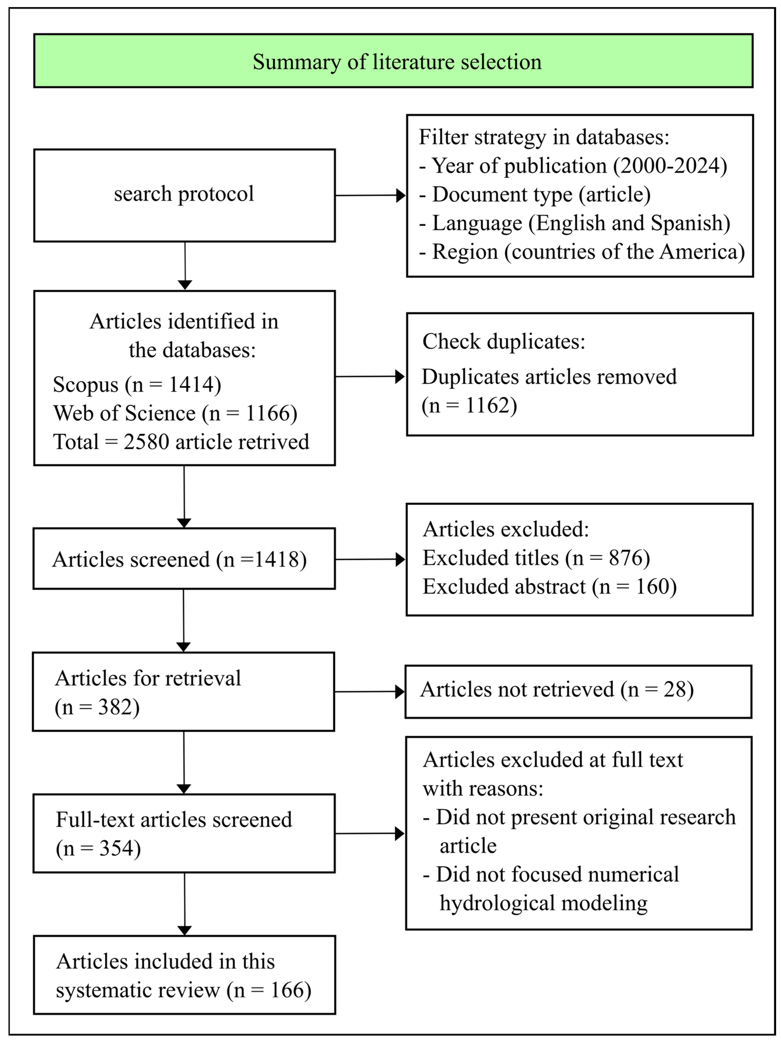
Figure 1. Process flowchart for the selection of articles using the methodology adapted of De León Pérez et al. [25].
Hydrology 11 00179 g001
Figure 2. Trends in publication on numerical modeling of groundwater flow over time.
Hydrology 11 00179 g002
Figure 3. Tree map with top ten journals with highest numbers of records observed.
Hydrology 11 00179 g003
Figure 4. Geographic distribution of the 166 articles published per country.
Hydrology 11 00179 g004
Figure 5. VOSviewer authors’ keyword co-occurrence.
Hydrology 11 00179 g005
Figure 6. Performance metrics employed for calibrating and validating hydrogeological models. (A) Combination of PMs used and (B) pie chart of the PMs used. Performance metrics: root mean square error (RMSE), coefficient of determination (R2), Nash–Sutcliffe efficiency (NSE), mean absolute error (MAE), correlation coefficient (R), normalized root mean square error (NRMSE), percentage of bias (PBIAS), mean error (ME), Kling–Gupta efficiency (KGE), modified Nash–Sutcliffe efficiency (mNSE), standard deviation of measured data (RSR), and normalized objective function (NOF).
Hydrology 11 00179 g006
Figure 7. Study units in the reviewed articles. (A) Fundamental units for hydrogeological numerical modeling of groundwater. (B) Aquifer types conceptualized in the studies.
Hydrology 11 00179 g007
Table 1. Search string for Scopus and Web of Science databases.
Scopus Search String
TITLE-ABS-KEY((“numerical groundwater model” OR “simulation groundwater model” OR “groundwater modeling” OR “hydrogeological modeling” OR “MODFLOW” OR “FEFLOW”) AND ((“aquifer” OR “aquifers”) OR (“basin” OR “Watershed”) OR “groundwater” OR “groundwater flow” OR “groundwater levels” OR “groundwater recharge” OR “groundwater management” OR “groundwater resources” OR “hydrogeological system” OR “forecast” OR “scenarios” OR “water resources management” OR “decision-making process” OR “uncertainty”)) AND (LIMIT-TO (PUBYEAR, 2024) OR LIMIT-TO (PUBYEAR, 2023) OR LIMIT-TO (PUBYEAR, 2022) OR LIMIT-TO (PUBYEAR, 2021) OR LIMIT-TO (PUBYEAR, 2020) OR LIMIT-TO (PUBYEAR, 2019) OR LIMIT-TO (PUBYEAR, 2018) OR LIMIT-TO (PUBYEAR, 2017) OR LIMIT-TO (PUBYEAR, 2016) OR LIMIT-TO (PUBYEAR, 2015) OR LIMIT-TO (PUBYEAR, 2014) OR LIMIT-TO (PUBYEAR, 2013) OR LIMIT-TO (PUBYEAR, 2012) OR LIMIT-TO (PUBYEAR, 2011) OR LIMIT-TO (PUBYEAR, 2010) OR LIMIT-TO (PUBYEAR, 2009) OR LIMIT-TO (PUBYEAR, 2008) OR LIMIT-TO (PUBYEAR, 2007) OR LIMIT-TO (PUBYEAR, 2006) OR LIMIT-TO (PUBYEAR, 2005) OR LIMIT-TO (PUBYEAR, 2004) OR LIMIT-TO (PUBYEAR, 2003) OR LIMIT-TO (PUBYEAR, 2002) OR LIMIT-TO (PUBYEAR, 2001) OR LIMIT-TO (PUBYEAR, 2000)) AND (LIMIT-TO (SRCTYPE, “j”)) AND (LIMIT-TO (DOCTYPE, “ar”)) AND (LIMIT-TO (LANGUAGE, “English”) OR LIMIT-TO (LANGUAGE, “Spanish”))
Web of Science Search String
((TS=((“numerical groundwater model” OR “simulation groundwater model” OR “groundwater modeling” OR “hydrogeological modeling” OR “MODFLOW” OR “FEFLOW”) AND ((“aquifer” OR “aquifers”) OR (“basin” OR “Watershed”) OR “groundwater” OR “groundwater flow” OR “groundwater levels” OR “groundwater recharge” OR “groundwater management” OR “groundwater resources” OR “hydrogeological system” OR “forecast” OR “scenarios” OR “water resources management” OR “decision-making process” OR “uncertainty”))) AND DT=(Article)) AND PY=(2000-2024)
Disclaimer/Publisher’s Note: The statements, opinions and data contained in all publications are solely those of the individual author(s) and contributor(s) and not of MDPI and/or the editor(s). MDPI and/or the editor(s) disclaim responsibility for any injury to people or property resulting from any ideas, methods, instructions or products referred to in the content.