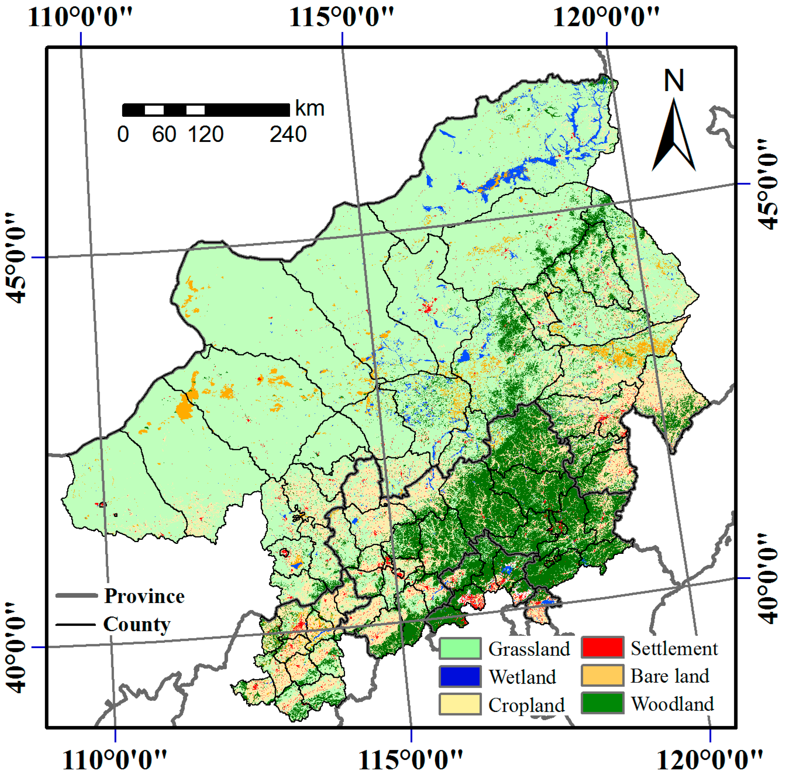
A 2001–2015 Archive of Fractional Cover of Photosynthetic and Non-Photosynthetic Vegetation for Beijing and Tianjin Sandstorm Source Region


Abstract
:1. Summary
2. Data Description
2.1. Data and Metadata
- ■
- Fractional cover of PV (%)
- ■
- Fractional cover of NPV (%)
- ■
- Fractional cover of bare soil (%)
2.2. Metadata
2.3. Dataset
- Characters 1–5: region name (btssr)
- Characters 6–7: variable name (pv, np, or bs)
- Characters 8–11: year (2001 to 2015)
- Characters 12–13: month (01 to 12)
3. Materials and Methods
3.1. Materials
3.1.1. Remotely Sensed Data
3.1.2. Field Spectroscopy
3.1.3. In Situ Fractional Ground Cover Data
3.2. Methods
3.2.1. Linear Spectral Mixture Model (LSMM)
3.2.2. Unmixing Technique
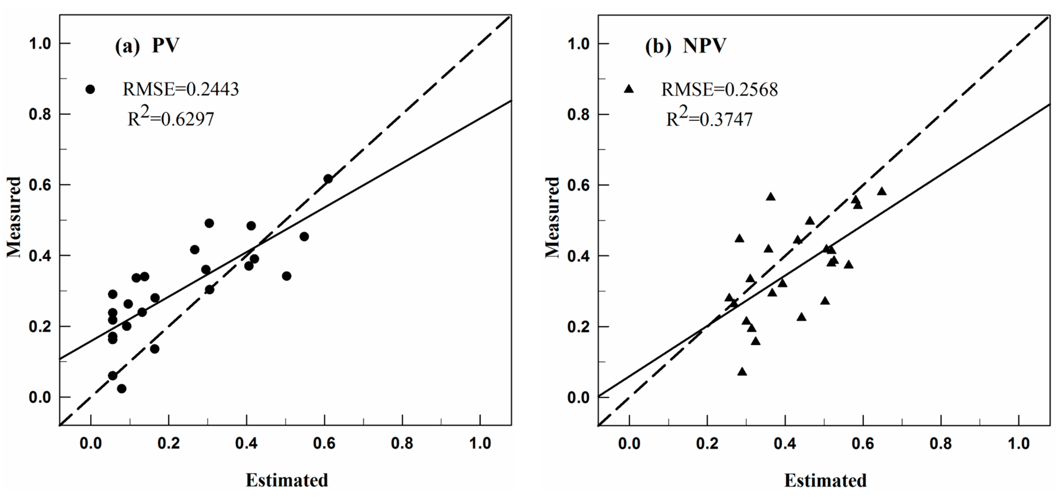
3.2.3. Accuracy Assessment
4. User Notes
Acknowledgments
Author Contributions
Conflicts of Interest
References
- Guerschman, J.P.; Hill, M.J.; Renzullo, L.J.; Barrett, D.J.; Marks, A.S.; Botha, E.J. Estimating fractional cover of photosynthetic vegetation, non-photosynthetic vegetation and bare soil in the Australian tropical savanna region upscaling the EO-1 Hyperion and MODIS sensors. Remote Sens. Environ. 2009, 113, 928–945. [Google Scholar] [CrossRef]
- Li, X.; Zhang, J. Derivation of the green vegetation fraction of the whole china from 2000 to 2010 from MODIS data. Earth Interact. 2016, 20, 1–16. [Google Scholar] [CrossRef]
- Jiang, Z.; Huete, A.R.; Chen, J.; Chen, Y.; Li, J.; Yan, G.; Zhang, X. Analysis of NDVI and scaled difference vegetation index retrievals of vegetation fraction. Remote Sens. Environ. 2006, 101, 366–378. [Google Scholar] [CrossRef]
- Gitelson, A.A.; Kaufman, Y.J.; Stark, R.; Rundquist, D. Novel algorithms for remote estimation of vegetation fraction. Remote Sens. Environ. 2002, 80, 76–87. [Google Scholar] [CrossRef]
- Okin, G.S. The contribution of brown vegetation to vegetation dynamics. Ecology 2010, 91, 743–755. [Google Scholar] [CrossRef] [PubMed]
- Aguilar, J.; Evans, R.; Daughtry, C. Performance assessment of the cellulose absorption index method for estimating crop residue cover. J. Soil Water Conserv. 2012, 67, 202–210. [Google Scholar] [CrossRef]
- Daughtry, C.S.; Doraiswamy, P.; Hunt, E., Jr.; Stern, A.; McMurtrey, J., III; Prueger, J. Remote sensing of crop residue cover and soil tillage intensity. Soil Tillage Res. 2006, 91, 101–108. [Google Scholar] [CrossRef]
- Ren, H.; Zhou, G.; Zhang, F.; Zhang, X. Evaluating cellulose absorption index (CAI) for non-photosynthetic biomass estimation in the desert steppe of inner Mongolia. Chin. Sci. Bull. 2012, 57, 1716–1722. [Google Scholar] [CrossRef]
- Asner, G.P.; Heidebrecht, K.B. Imaging spectroscopy for desertification studies: Comparing AVIRIS and EO-1 Hyperion in Argentina drylands. IEEE Trans. Geosci. Remote Sens. 2003, 41, 1283–1296. [Google Scholar] [CrossRef]
- Huete, A.R.; Miura, T.; Gao, X. Land cover conversion and degradation analyses through coupled soil-plant biophysical parameters derived from hyperspectral EO-1 Hyperion. IEEE Trans. Geosci. Remote Sens. 2003, 41, 1268–1276. [Google Scholar] [CrossRef]
- Qi, J.; Wallace, O. Biophysical attributes estimation from satellite images in arid regions. In Proceedings of the 2002 IEEE International Geoscience and Remote Sensing Symposium (IGARSS’02), Toronto, ON, Canada, 24–28 June 2002; pp. 2000–2002. [Google Scholar]
- Cao, X.; Chen, J.; Matsushita, B.; Imura, H. Developing a MODIS-based index to discriminate dead fuel from photosynthetic vegetation and soil background in the Asian steppe area. Int. J. Remote Sens. 2010, 31, 1589–1604. [Google Scholar] [CrossRef]
- Okin, G.S. Relative spectral mixture analysis—A multitemporal index of total vegetation cover. Remote Sens. Environ. 2007, 106, 467–479. [Google Scholar] [CrossRef]
- Okin, G.S.; Clarke, K.D.; Lewis, M.M. Comparison of methods for estimation of absolute vegetation and soil fractional cover using MODIS normalized BRDF-adjusted reflectance data. Remote Sens. Environ. 2013, 130, 266–279. [Google Scholar] [CrossRef]
- Guerschman, J.P.; Scarth, P.F.; McVicar, T.R.; Renzullo, L.J.; Malthus, T.J.; Stewart, J.B.; Rickards, J.E.; Trevithick, R. Assessing the effects of site heterogeneity and soil properties when unmixing photosynthetic vegetation, non-photosynthetic vegetation and bare soil fractions from Landsat and MODIS data. Remote Sens. Environ. 2015, 161, 12–26. [Google Scholar] [CrossRef]
- Scarth, P.; Röder, A.; Schmidt, M.; Denham, R. Tracking Grazing Pressure and Climate Interaction—The Role of Landsat Fractional Cover in Time Series Analysis. In Proceedings of the 15th Australasian Remote Sensing and Photogrammetry Conference, Alice Springs, Australia, 13–17 September 2010; pp. 13–17. [Google Scholar]
- Li, X.; Zheng, G.; Wang, J.; Ji, C.; Sun, B.; Gao, Z. Comparison of methods for estimating fractional cover of photosynthetic and non-photosynthetic vegetation in the Otindag sandy land using GF-1 wide-field view data. Remote Sens. 2016, 8, 800. [Google Scholar] [CrossRef]
- Schaaf, C.B.; Gao, F.; Strahler, A.H.; Lucht, W.; Li, X.; Tsang, T.; Strugnell, N.C.; Zhang, X.; Jin, Y.; Muller, J.-P.; et al. First operational BRDF, albedo nadir reflectance products from MODIS. Remote Sens. Environ. 2002, 83, 135–148. [Google Scholar] [CrossRef]
- Goldblatt, R.; You, W.; Hanson, G.; Khandelwal, A.K. Detecting the Boundaries of Urban Areas in India: A Dataset for Pixel-Based Image Classification in Google Earth Engine. Remote Sens. 2016, 8, 634. [Google Scholar] [CrossRef]
- Muir, J.; Schmidt, M.; Tindall, D.; Trevithick, R.; Scarth, P.; Stewart, J. Field Measurement of Fractional Ground Cover: A Technical Handbook Supporting Ground Cover Monitoring for Australia; ABARES: Canberra, Australia, 2011. [Google Scholar]
- Heinz, D.C.; Chang, C.-I. Fully constrained least squares linear spectral mixture analysis method for material quantification in hyperspectral imagery. IEEE Trans. Geosci. Remote Sens. 2001, 39, 529–545. [Google Scholar] [CrossRef]
- Chang, C.-I.; Heinz, D.C. Constrained subpixel target detection for remotely sensed imagery. IEEE Trans. Geosci. Remote Sens. 2000, 38, 1144–1159. [Google Scholar] [CrossRef]


| Characteristic | Description |
|---|---|
| Data format | GeoTiff |
| Data type | Unsigned integer |
| Time span | 2001–2015 |
| Coordinate system | latitude/longitude WGS84 (EPSG:4326) |
| Image dimensions | 2612 × 1765 (columns × rows) |
| No data value | 255 |
| Number of layers | 3 |
| Spatial resolution | 0.004492 |
| Data range | 0–100 |
© 2017 by the authors. Licensee MDPI, Basel, Switzerland. This article is an open access article distributed under the terms and conditions of the Creative Commons Attribution (CC BY) license (http://creativecommons.org/licenses/by/4.0/).
Share and Cite
Li, X.; Li, Z.; Ji, C.; Wang, H.; Sun, B.; Wu, B.; Gao, Z. A 2001–2015 Archive of Fractional Cover of Photosynthetic and Non-Photosynthetic Vegetation for Beijing and Tianjin Sandstorm Source Region. Data 2017, 2, 27. https://doi.org/10.3390/data2030027
Li X, Li Z, Ji C, Wang H, Sun B, Wu B, Gao Z. A 2001–2015 Archive of Fractional Cover of Photosynthetic and Non-Photosynthetic Vegetation for Beijing and Tianjin Sandstorm Source Region. Data. 2017; 2(3):27. https://doi.org/10.3390/data2030027
Chicago/Turabian StyleLi, Xiaosong, Zengyuan Li, Cuicui Ji, Hongyan Wang, Bin Sun, Bo Wu, and Zhihai Gao. 2017. "A 2001–2015 Archive of Fractional Cover of Photosynthetic and Non-Photosynthetic Vegetation for Beijing and Tianjin Sandstorm Source Region" Data 2, no. 3: 27. https://doi.org/10.3390/data2030027