Colonialism and Toponyms in Singapore
Abstract
:1. Introduction
2. Place Names
The conscious use of place-names by a state can be seen as an instrument to preserve the unity and uniqueness of the nation; to enforce in the national consciousness its moral right to inhabit a particular territory; to protect its land from the territorial claims of its neighbours; or to justify its own territorial claims. A recreated or artificially created place-name landscape is a symbolic part of national identity.(p. 180)
3. Selected Toponymic Changes in Singapore
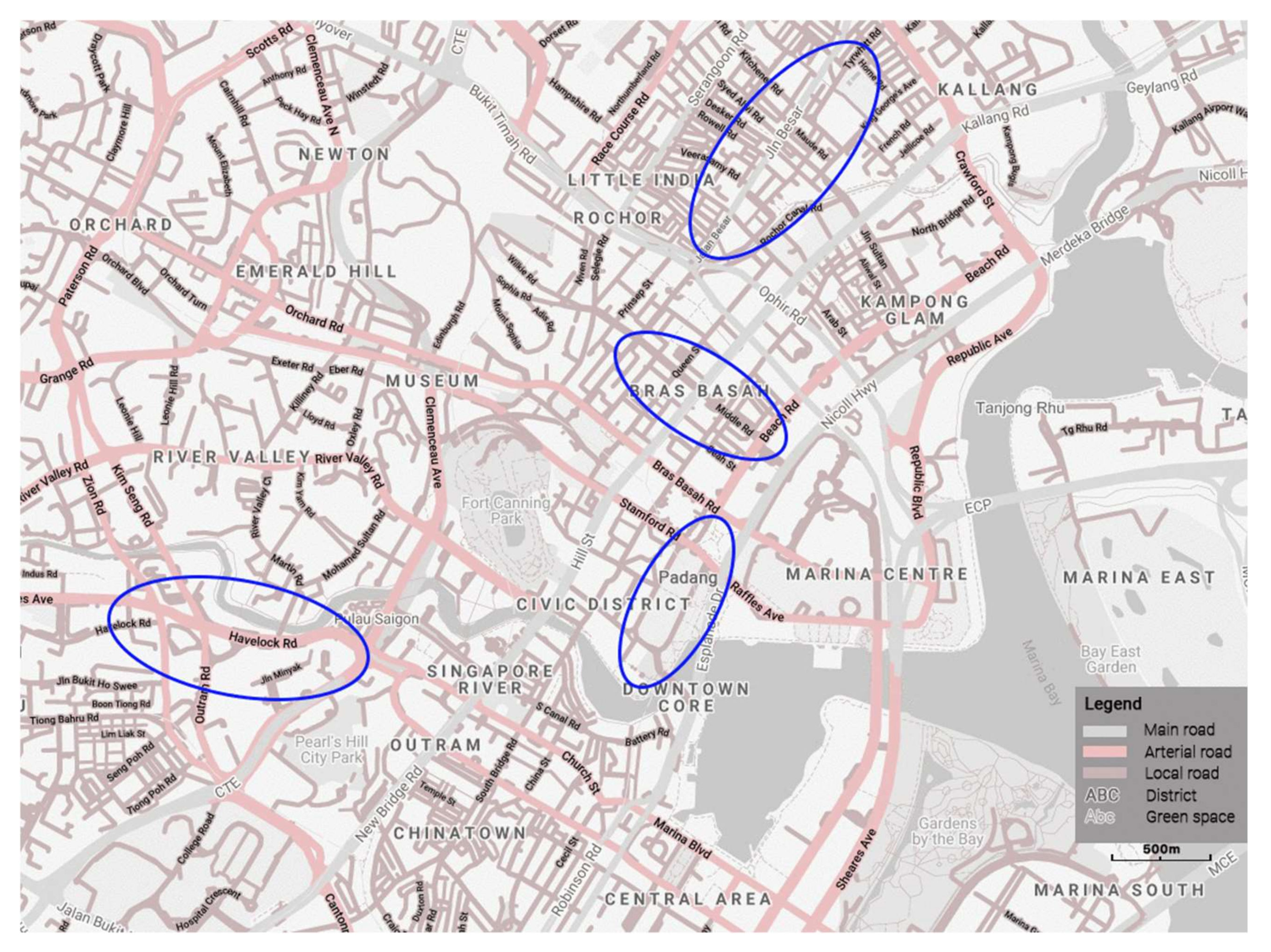
3.1. Jalan Besar
3.2. Havelock Road
3.3. Middle Road
3.4. The Padang
4. Conclusions
Author Contributions
Funding
Acknowledgments
Conflicts of Interest
References
- Helleland, B. Place Names and Identities. Oslo Stud. Lang. 2012, 4, 95–116. [Google Scholar] [CrossRef]
- Nyström, S. Names and meaning. In The Oxford Handbook of Names and Naming; Hough, C., Ed.; Oxford University Press: Oxford, UK, 2016; pp. 39–51. [Google Scholar]
- Basso, K.H. Western Apache Language and Culture: Essays in Linguistic Anthropology; The University of Arizona Press: Tuscon, AR, USA, 1990. [Google Scholar]
- Cohen, S.B.; Kliot, N. Place-Names in Isarael’s Ideological Struggle over the Administered Territories. Ann. Assoc. Am. Geogr. 1992, 82, 653–680. [Google Scholar] [CrossRef]
- Monmonier, M. From Squaw Tit to Whorehouse Meadow: How Maps Name, Claim, and Inflame; The University of Chicago Press: Chicago, IL, USA; London, UK, 2007. [Google Scholar]
- Rose-Redwood, R.S. “Reclaim, Rename, Reoccupy”: Decolonising Place and the Reclaiming of PKOLS. ACME Int. J. Crit. Geogr. 2016, 15, 187–206. [Google Scholar]
- Saparov, A. The alteration of place names and construction of national identity in Soviet Armenia. Cahiers du Monde Russe 2003, 44, 179–198. [Google Scholar]
- Ndletyana, M. Changing place names in post-apartheid South Africa: Accounting for the unevenness. Soc. Dyn. 2012, 18, 87–103. [Google Scholar] [CrossRef]
- Ashcroft, B.; Griffiths, G.; Tiffin, H. (Eds.) The Post-Colonial Studies Reader; Routledge: London, UK; New York, NY, USA, 2003. [Google Scholar]
- Rose-Redwood, R.S.; Alderman, D.H.; Azaryahu, M. Geographies of toponymic inscription: New directions in critical place-name studies. Prog. Hum. Geogr. 2010, 34, 453–470. [Google Scholar] [CrossRef]
- Cavallaro, F.; Perono Cacciafoco, F.; Tan, Z.X. Sequent Occupance and Toponymy in Singapore: The diachronic and synchronic development of urban place names. Urban Sci. Spec. Issue Urban Place Names Political Econ. Cult. Dimens. 2019, 3, 98. [Google Scholar] [CrossRef] [Green Version]
- Yeoh, B.S.A. Street-naming and nation-building: Toponymic inscriptions of nationhood in Singapore. Area 1996, 28, 298–307. [Google Scholar]
- Yeoh, B.S.A. Street names in colonial Singapore. Geogr. Rev. 1992, 82, 313–322. [Google Scholar] [CrossRef]
- Haughton, H.T. Native Names of Streets in Singapore. J. Malay. Branch R. Asiat. Soc. 1891, 6, 49–65. [Google Scholar]
- Savage, V.R.; Yeoh, B.S.A. Singapore Street Names: A Study of Toponymics; Marshall Cavendish Editions: Singapore, 2013. [Google Scholar]
- Lim, S.T.G.; Perono Cacciafoco, F. Then and Now: A Comparative Historical Toponomastics Analysis of Station Names in 2 of Singapore’s Mass Rapid Transit (MRT) Lines. Urban Sci. 2020, 4, 37. [Google Scholar] [CrossRef]
- Woo, P.L. A Street of elusive significance: Hamilton road, Singapore. In On Asian Streets and Public Space; Heng, C.K., Low, B.L., Hee, L., Eds.; NUS Press: Singapore, 2010; pp. 25–38. [Google Scholar]
- Woo, P.L. Jalan Besar—From Mangrove Swampland to Charming District. Skyline 2011, 18–21. Available online: https://www.ura.gov.sg/Conservation-Portal/Resources/Articles?bldgid=JLNBSR (accessed on 19 November 2020).
- Jalan Besar: A Heritage Trail; Thangamma, K. (Ed.) National Heritage Board: Singapore, 2012. [Google Scholar]
- Renuka, M. Jalan Besar. Available online: https://eresources.nlb.gov.sg/infopedia/articles/SIP_585_2005-01-13.html (accessed on 20 June 2020).
- Anonimous. Land Divisions at Sarangong (Serangoon) Road, Dunlop Street, Jalan Besar, Syed Alwi Road and its Surroundings. National Archives of Singapore. c 1845. Available online: https://www.nas.gov.sg/archivesonline/maps_building_plans/record-details/fa3b5093-115c-11e3-83d5-0050568939ad (accessed on 19 November 2020).
- Ng, Y.P. What’s in The Name? How the Streets and Villages in Singapore Got Their Names; World Scientific Publishing: Singapore, 2017. [Google Scholar]
- Firmstone, H.W. Chinese Names of Streets and Places in Singapore and the Malay Peninsula. J. Straits Branch R. Asiat. Soc. 1905, 42, 53–208. [Google Scholar]
- Tan, K.S.; Firmstone, H.W.; Bailey, A.W.; Baddeley, F.M. An Index [in Romanised Hokkien and Cantonese to] “The Chinese Names of Streets and Places in Singapore” (Concluded). J. Straits Branch R. Asiat. Soc. 1906, 46, 195–213. [Google Scholar]
- Woo, P.L. The changing landscape of Jalan Besar. In Changing Landscapes of Singapore: Old Tensions, New Discoveries; Ho, E., Woon, C., Ramdas, K., Eds.; NUS Press: Singapore, 2013; pp. 259–281. [Google Scholar]
- Anonimous. New Singapore Street Map. National Archives of Singapore, Tokyo. c 1930–1935. Available online: https://www.nas.gov.sg/archivesonline/maps_building_plans/record-details/f7db6648-115c-11e3-83d5-0050568939ad (accessed on 19 November 2020).
- Thomson, J.T. Plan of Singapore Town and Adjoining Districts from Actual Survey by John Turnbull Thomson, Government Surveyor, Singapore. National Archives of Singapore. J.M. Richardson: London, UK, 1846. Available online: https://www.nas.gov.sg/archivesonline/maps_building_plans/record-details/322cd444-035e-11e9-9481-001a4a5ba61b (accessed on 19 November 2020).
- Thambo, P. Map of Singapore Town Showing Building Allotments and registered Numbers of Crown Leases. National Archives of Singapore, Surveyor-General: Federated Malay States. 1881. Available online: https://www.nas.gov.sg/archivesonline/maps_building_plans/record-details/f8d73ed8-115c-11e3-83d5-0050568939ad (accessed on 19 November 2020).
- Moniot, J.; Singapore Residency. The National Archives, United Kingdom. c 1860. Available online: https://www.nas.gov.sg/archivesonline/maps_building_plans/record-details/b7ce9e81-57a3-11e6-b4c5-0050568939ad (accessed on 19 November 2020).
- Lai, C.K. Multi-ethnic Enclaves around Middle Road: An Examination of Early Urban Settlement in Singapore. BiblioAsia 2006, 2, 4–11. [Google Scholar]
- Coleman, G.D.; Tassin, J.B. Map of The Town And Environs of Singapore. National Archives of Singapore. 1836. Available online: http://www.nas.gov.sg/archivesonline/maps_building_plans/record-details/f96ffb35-115c-11e3-83d5-0050568939ad (accessed on 19 November 2020).
- Jackson, P. Plan of the Town of Singapore. National Archives of Singapore, London. 1828. Available online: https://www.nas.gov.sg/archivesonline/maps_building_plans/record-details/f9926418-115c-11e3-83d5-0050568939ad (accessed on 19 November 2020).
- Blackburn, K. Heritage Site, War Memorial, and Tourist Stop: The Japanese Cemetery of Singapore. J. Malays. Branch R. Asiat. Soc. 2007, 80, 17–39. [Google Scholar]
- The Roman Catholic Archdiocese of Singapore. St Joseph’s Church. Available online: https://history.catholic.sg/st-josephs-church (accessed on 10 October 2020).
- Lai, C.K. Maidan to Padang: Reinventions of Urban Fields in Malaysia and Singapore. Tradit. Dwell. Settl. Rev. 2010, 21, 55–70. [Google Scholar]
- Home, R. The ‘Grand Modell’ of colonial settlement. In Of Planting and Planning: The Making of British Colonial Cities; Home, R., Ed.; Routledge: London, UK, 1997; pp. 8–35. [Google Scholar]
- Wan, M.H.; Lau, J. Heritage Places of Singapore; Marshall Cavendish Editions: Singapore, 2009. [Google Scholar]
- Thomson, J.T. Plan of Singapore Town and Adjoining Districts from Actual Survey by John Turnbull Thomson, Governor Surveyor. National Archives of Singapore. 1844. Available online: https://www.nas.gov.sg/archivesonline/maps_building_plans/record-details/fa350bf9-115c-11e3-83d5-0050568939ad (accessed on 19 November 2020).
- McCallum, H.E. Plan of the Waterfront at Singapore. National Archives of Singapore. McCallum, H.E.: London, UK, 1890. Available online: https://www.nas.gov.sg/archivesonline/maps_building_plans/record-details/b662b1b8-57a3-11e6-b4c5-0050568939ad (accessed on 19 November 2020).
- Anonimous. Map of Singapore. National Archives of Singapore. 1912. Available online: https://www.nas.gov.sg/archivesonline/maps_building_plans/record-details/9e17640e-d90f-11e9-90d4-001a4a5ba61b (accessed on 19 November 2020).


Publisher’s Note: MDPI stays neutral with regard to jurisdictional claims in published maps and institutional affiliations. |
© 2020 by the authors. Licensee MDPI, Basel, Switzerland. This article is an open access article distributed under the terms and conditions of the Creative Commons Attribution (CC BY) license (http://creativecommons.org/licenses/by/4.0/).
Share and Cite
Yom, S.J.; Cavallaro, F. Colonialism and Toponyms in Singapore. Urban Sci. 2020, 4, 64. https://doi.org/10.3390/urbansci4040064
Yom SJ, Cavallaro F. Colonialism and Toponyms in Singapore. Urban Science. 2020; 4(4):64. https://doi.org/10.3390/urbansci4040064
Chicago/Turabian StyleYom, Samantha JingYi, and Francesco Cavallaro. 2020. "Colonialism and Toponyms in Singapore" Urban Science 4, no. 4: 64. https://doi.org/10.3390/urbansci4040064
APA StyleYom, S. J., & Cavallaro, F. (2020). Colonialism and Toponyms in Singapore. Urban Science, 4(4), 64. https://doi.org/10.3390/urbansci4040064


