- Article

Mapping and Monitoring Peri-Urban Territorial Dynamics Using Multi-Source Geospatial Data: A Case of the Casablanca Region
- Asmaa Moussaoui,
- Ilyas Maataoui and
- Kenza Aitelkadi
- + 2 authors
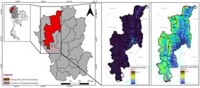
Peri-urbanization is one of the most complex and rapidly territorial phenomena in African metropolitan areas, including Morocco. This dynamic, characterized by unplanned urban growth, presents significant challenges in terms of land management and sustainable territorial planning. In this context, this work proposes a methodology for detecting and analyzing peri-urban areas using a deep learning model based on the Global Human Settlement Layer and Global Land Analysis and Discovery Land Cover data. The Multi-Layer Perceptron model was trained on a manually annotated dataset covering the Casablanca metropolitan region and then used to classify the area into four categories: urban, peri-urban, rural, and water. Model interpretability was ensured through the Shapley Additive Explanations method, and a diachronic analysis was conducted from 2005 to 2025. The model achieved high accuracy (90.6%), with strong performance in identifying urban (F1 ≈ 0.996) and rural (F1 ≈ 0.94) areas. However, peri-urban areas represent some challenges, which result in a lower F1-score of about 0.63 due to transitional land patterns. The results reveal a significant expansion of peri-urban areas (+28,000 ha) at the expense of rural lands. These findings offer valuable insights for policymakers to develop sustainable land-use planning strategies and to anticipate urban sprawl dynamics.
5 February 2026
![Study area [44].](https://mdpi-res.com/cdn-cgi/image/w=470,h=317/https://mdpi-res.com/urbansci/urbansci-10-00101/article_deploy/html/images/urbansci-10-00101-g001-550.jpg)