Article

A Framework for Integrating Freight Transport, Urban Land Planning, and Infrastructure Management under Economic Geography Principles

by
Humberto Barrera-Jiménez
1 and
Juan Pineda-Jaramillo
2,*
1
Transport, Health and Urban Systems Research Lab, Melbourne School of Design, Faculty of Engineering and IT, The University of Melbourne, Melbourne 3052, Australia
2
Faculty of Mines, Medellin Campus, National University of Colombia, Medellin 050034, Colombia
*
Author to whom correspondence should be addressed.
Urban Sci. 2024, 8(2), 30; https://doi.org/10.3390/urbansci8020030
Submission received: 20 February 2024 / Revised: 4 April 2024 / Accepted: 8 April 2024 / Published: 10 April 2024

Abstract

:
This study presents a conceptual framework proposal for integrating urban freight initiatives (UFIs), or city logistics initiatives, into urban planning and urban management (UPUM) land use and infrastructure systems. As a novel approach, this framework integrates three components: Firstly, a conceptual basis on three economic geography theory principles—location, agglomeration, and urbanisation. Secondly, spatial analysis and subsequent clustering integrate companies’ spatial positions, their proximity to other companies, their freight intensity, and the characteristics of the zonal road infrastructure; these clusters are defined as freight traffic zones (FTZs). Thirdly, a functional yet strategic UFI clustering or grouping is proposed to work in an optimised and integrated manner with the FTZs’ opportunities for efficiency and reduced externalities. It is expected that the integrated result of these three components can serve to optimise freight initiatives and road infrastructure from a city governance perspective, reduce freight externalities, and function as a stakeholder cooperation tool from government-led, policy-driven perspectives. This research also identifies and characterises various variables influencing the emergence and existence (planned or organic) of FTZs and shows how these could be incorporated into high-level UPUM processes. Although it is deemed that the principles and methodological approach followed here could be common to urban areas, an example for the Metropolitan Area of the Aburra Valley (MAAV), in Colombia, is presented as an initial case study. Conclusively, this paper introduces a pioneering methodology for integrating UFIs into city or metropolitan governance, offering guidance for policymakers to promote sustainable freight systems.

1. Introduction

The intersection of transport with urban development, environmental sustainability, and socio-economic dynamics constitutes a multifaceted domain that underscores transport as a fundamentally interdisciplinary field. Encompassing economic and social sciences, urban and regional planning, physical and environmental engineering, governance, energy, and public policy, transport research and practice engage with a broad spectrum of academic and practical fields [1,2,3].
Passenger transport studies traditionally adopt a “home-based” mobility analysis, predicated on the assumption that travel starts from homes in the morning for work or study and concludes with the return journey in the evening [4,5,6]; this assumption aligns well with the observed patterns of urban environments. Conversely, freight transport requires alternative analytical approaches that account for distinct temporal, spatial, social, operational, and sustainability considerations, diverging from passenger transport paradigms [7,8,9].
It is argued here that a key distinction of freight transport lies in the spatiality of both the origins and destinations of goods movements, highlighting the importance of this approach in enhancing the reliability of analysis and policy implementation for urban issues involving multiple stakeholders [10,11,12]. Passenger origin–destination (O-D) matrixes serve to delineate residential, industrial, and service areas through travel behaviour characterisation. Yet, the entropy maximisation principles for industries and freight transport variables deviate from passenger transport methodologies, underscoring the necessity for a differentiated approach for describing, diagnosing, and planning urban freight systems in relation to the built environment [13,14,15].
The urban form is pivotal in linking built environment distribution and characteristics with freight transport planning potential, but most research around this topic has been conducted from the perspectives of both operations research and traffic engineering. That is, an interest in optimising travel times and distances or in-vehicle capacity has been the common approach; when system-wide optimisation has been studied, it has usually been around optimising operations amongst carriers or other forms of industry-driven approaches [16,17]. Research that considers both the economic nature of businesses (that derive from how freight-intensive they are) and the spatial configuration of cities around roads (as both the cause and effect) is still largely missing from the literature [18]. Furthermore, optimisation approaches from the perspective of governments, that is, how to design and deploy policies around the efficient use of infrastructures for efficient freight movements without externalizing negative impacts to other infrastructure uses, are still missing [19,20]. This paper presents an attempt to cover that gap.
Urban freight dynamics significantly influence infrastructure utilisation and, therefore, transport externalities, companies (shippers and receivers) size, temporal patterns, fleet types, infrastructure conditions, assistive technologies, and freight types typically emerge as essential planning variables for freight operations [21,22,23,24] but are rarely considered for government-led infrastructure planning and management. Spatial analysis of companies’ locations through the lens of economic geography principles provides a framework for defining FTZ, facilitating the application of UFI through a spatial and operational conditions-based analysis [25].
In addressing the complexities of urban freight transport, this study recognises the paramount importance of innovative solutions and sustainable practices. The increasing interest in urban freight logistics underscores the pressing need for a comprehensive understanding of the challenges and opportunities present in rapidly urbanizing regions. The Metropolitan Area of the Aburra Valley (MAAV), in Colombia, exemplifies such a region, where dynamic economic activities, complex urban form, and diverse topography converge, presenting unique challenges for freight transport planning. This case study aims to offer valuable insights into the strategic integration of freight logistics within urban development schemes [26]. The spatio-temporal evolution of port and shipping service enterprises within the MAAV and similar urban contexts reveals a nuanced understanding of the logistics sector spatial organisation. It highlights the pivotal role of ports in the global value chain network, underscoring the significance of spatial planning and economic geography in addressing urban freight challenges. Such an analysis is essential for identifying FTZ, optimising infrastructure utilisation, and facilitating the application of UFI [27].
Furthermore, the journey towards more sustainable and efficient urban freight systems has placed a spotlight on green innovation and the environmental implications of transport infrastructure. The impact of cross-border freight projects on cities’ green innovation intensity highlights a complex interplay between freight efficiency and environmental stewardship. This relationship underscores the necessity for policies that balance the operational demands of urban freight with the imperative of environmental sustainability [28].
Investigating the spatial organisation patterns within urban networks through community detection algorithms offers profound insights into optimising urban spaces for sustainable development. Such studies reveal spatial differentiation and accessibility patterns across transport modes, enriching the state-of-the-art knowledge of urban network dynamics. This approach is crucial for fostering sustainable urban development and addressing the multifaceted challenges posed by urban freight transport [29].
This study aims to bridge the identified research gap in freight transport planning by grounding its theoretical framework in economic geography and employing GIS-based spatial analysis to cluster FTZs. To show an application of the framework, a case study of the Metropolitan Area of the Aburra Valley (MAAV), in Colombia, illustrates the practical insights this approach can provide for designing and optimising government-led optimisation and improvement of road usage and transport systems [26].

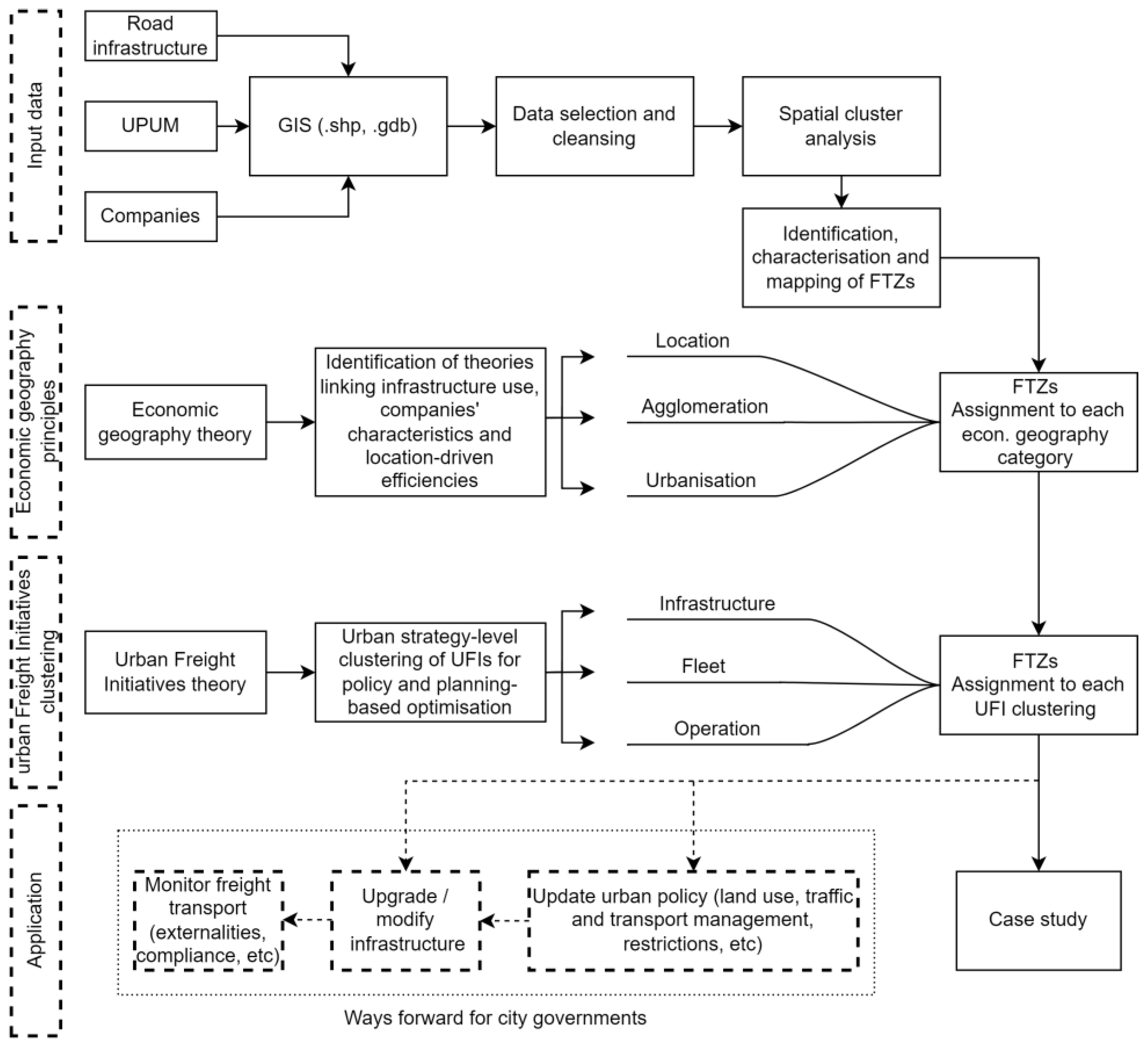
2. Theory, Data, Methodology, and Application

2.1. Theory and Data

Most companies and industries are for-profit organisations and, therefore, their locations usually represent efficiency opportunities (reduced costs and increased benefits), be it from the supply and shipping of raw materials and finished products or the ease of access to necessary services, knowledge, or utilities. This fundamental condition is explained by the economic geography concepts of agglomeration, location, and urbanisation.
The common definitions of these in the literature, adapted to their potential relationships with freight planning, are as follows:
  • Agglomeration economies: This refers to the benefits that firms and industries—usually from the same or non-competing industries—gain from being located close to each other within a geographic area.
  • Location economies: This concept focuses more broadly on the advantages a firm’s gain from choosing a specific geographic location for its operations due to the ease of access to key resources, such as supplies or energy sources, markets, transport hubs, favourable regulatory environments, etc.
  • Urbanisation economies: This refers to the benefits gained from close proximity to common features of urbanised environments, such as advanced telecommunications, government, financial services, and skilled labour.
On the same topic, economic geography informs the physical locations of companies through three spatial grouping structures:
  • Inner economies of a company: Highlighting productive, distributive, and financial economies of scale.
  • Outer economies within an industry: Derived from the concentrated localization of similar industry companies.
  • Urbanisation economies: External to the company and industry, benefiting from generic urban infrastructures and diverse institutional interactions.
It is proposed here that, by these definitions, policy towards the government-led integration of UFIs can be designed by considering road infrastructure as a common good for companies in close proximity.
Regarding data requirements, with the condition of urban data being highly site-specific due to the uniqueness of cities and different data governance schemes, each city (or urbanised region) produces different sets and qualities of geographic transport dynamics and spatial economic data. Aiming at the replicability and transferability of the framework, it is proposed that at least three large groups of datasets are collected: road infrastructure (and ideally, road usage), land use, and economic geography (companies’ locations, sizes, types, etc.). For roads, their offer (geometry, hierarchy, and design, including parking and loading conditions) and demand (traffic levels, safety, and public transport operations) parameters are required; for land use mix, blocks and corridors, topography, and planning schemes are also required; lastly, for economic geography, geospatial data about the companies’ locations and nature are essential. If additional data about measured or model freight demand are available, they can be incorporated.
In the case presented here, all data was collected from open-data portals of the areas evaluated, both from governments and authorities as well as Chambers of Commerce, mobility studies, and traffic counts. The data used to define this approach are described in Table 1.

2.2. Methodology Outline

This framework integrates three components:
  • A theoretical foundation on economic geography theory;
  • A spatial cluster analysis of the integration of infrastructure, land use, and companies’ locations;
  • A high-level grouping or clustering of UFIs.
The overall process is presented in Figure 1.

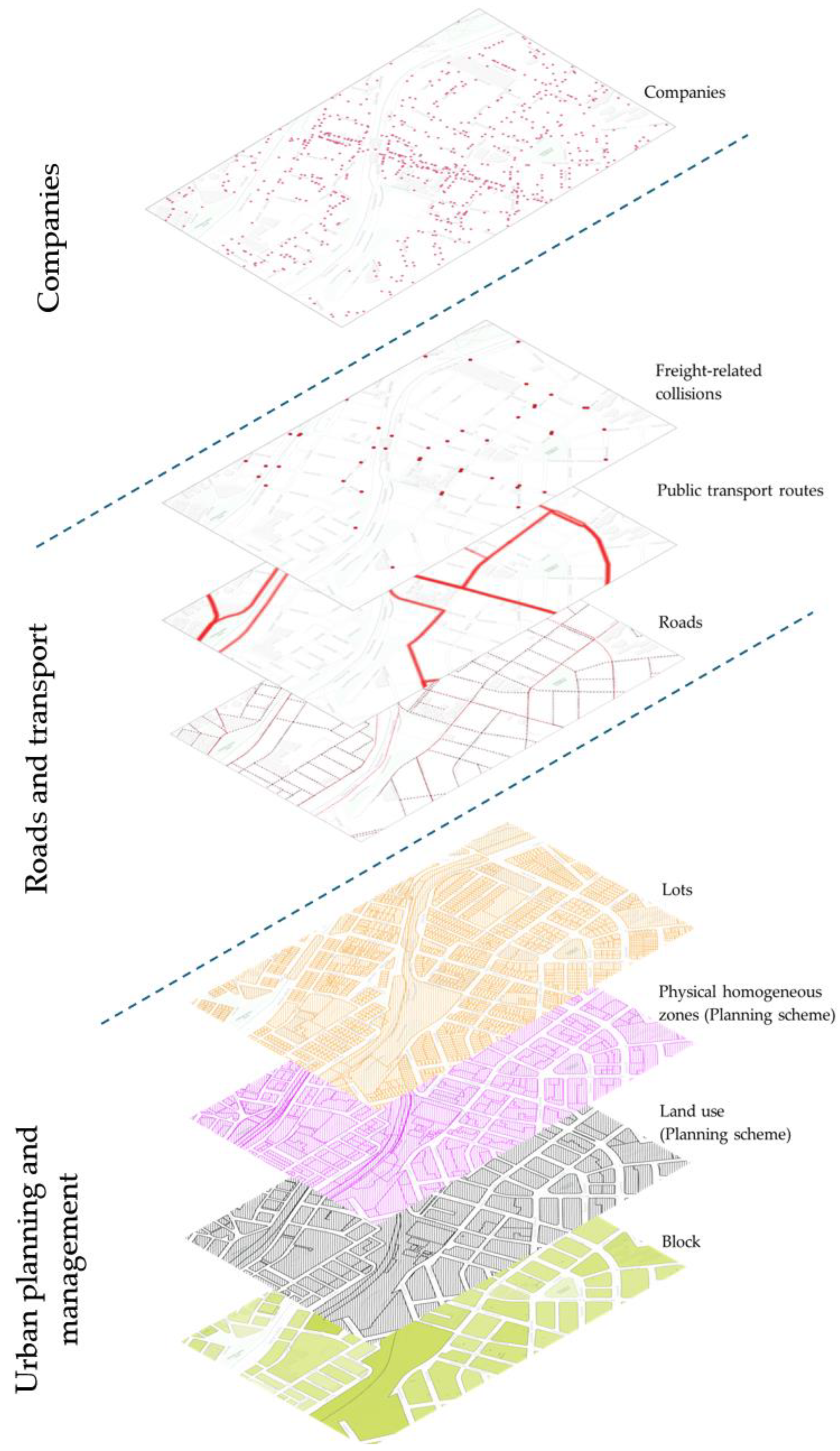
2.3. A Systemic Approach from the Spatial and Economic Aspects of Companies and Their Freight Demand

The fundamental economic geography theory (first component of the methodology shown in Figure 1) is presented in Section 2.1. This section outlines a systemic methodology for identifying, characterising, and mapping FTZs based on the spatial and economic characteristics of companies and their freight demand. An FTZ is identified under the following criteria:
  • Geographical proximity: Companies or facilities within a FTZ share a close geographical context, unified by common mobility infrastructure, facilitating a cohesive urban planning approach to UFI.
  • Common supply or demand nature: Entities within the zone exhibit similar freight needs, such as fleet characteristics and frequency requirements, allowing for targeted interventions to address their shared logistical challenges.
  • Collective impact on infrastructure: The cumulative activities of these companies significantly affect mobility infrastructure in terms of congestion, capacity, and peak-hour usage, requiring a coordinated management approach.
  • Potential for joint UFIs: Despite varying industrial sectors, companies within an FGZ can benefit from collaborative strategies to enhance their collective freight transport efficiency and sustainability.
Determining the boundaries of an FTZ involves:
  • Infrastructure-defined borders: The zone’s periphery is primarily designated by the physical extents of the relevant mobility infrastructure, ensuring that the defined area accurately reflects the operational landscape.
  • Consideration of physical and urban barriers: Exceptions to infrastructure-based demarcation are made in cases of significant physical landscape barriers or when a block of urban fabric exhibits stark (>50%) land-use differences from one side to the other, based on cadastral records. This nuanced approach ensures that the zone boundaries accurately encapsulate the operational and spatial dynamics of the freight generators.
The methodology emphasises freight demand management through a lens that integrates the spatial organisational patterns and economic conditions of companies (see Figure 2). This approach serves as a foundation for understanding and addressing the operational and infrastructural needs of an FTZ, promoting efficient and sustainable urban freight planning solutions, primarily from the perspective of the design and implementation of public policy.
As the third leg of the methodology, state-of-the-art developments in UFIs were considered. In essence, what is most relevant for this framework is to consider UFIs to a high-level strategic extent, that is, to identify the most comprehensive set of UFIs that might be considered for planning and public policy purposes. For this purpose, an inventory of UFIs was identified within the literature [30]. Since this inventory is both comprehensive and evidence-based, it was used here as the basis for selecting and assigning UFIs to the FTZ according to what was previously described as the rationale for the spatial clustering and its relationship with all three economic geographies. The referenced inventory presents the following structure: it contains fifty-four initiatives, which are classified and organised into eight groups (infrastructure management, parking/loading management, vehicle-related strategies, traffic management, pricing/incentives/taxation, logistical management, demand/land use management, and stakeholder engagement). This structure, whilst comprehensive, does not directly serve to organise area-wide clusters of companies, or most importantly, to optimise road use. Therefore, the following clustering of initiatives, a simplified version—with three components—for ease of public policy design and deployment, is proposed as part of this framework and presented in Table 2.
This framework proposes that each FTZ (depending on how they are classified (agglomeration, location, or urbanisation) as a product of the spatial cluster analysis, can be planned and managed in an optimal and zone-based efficient manner, if the policies around the land use and infrastructure operation in and around them prioritise the following UFIs, as presented in Table 3.

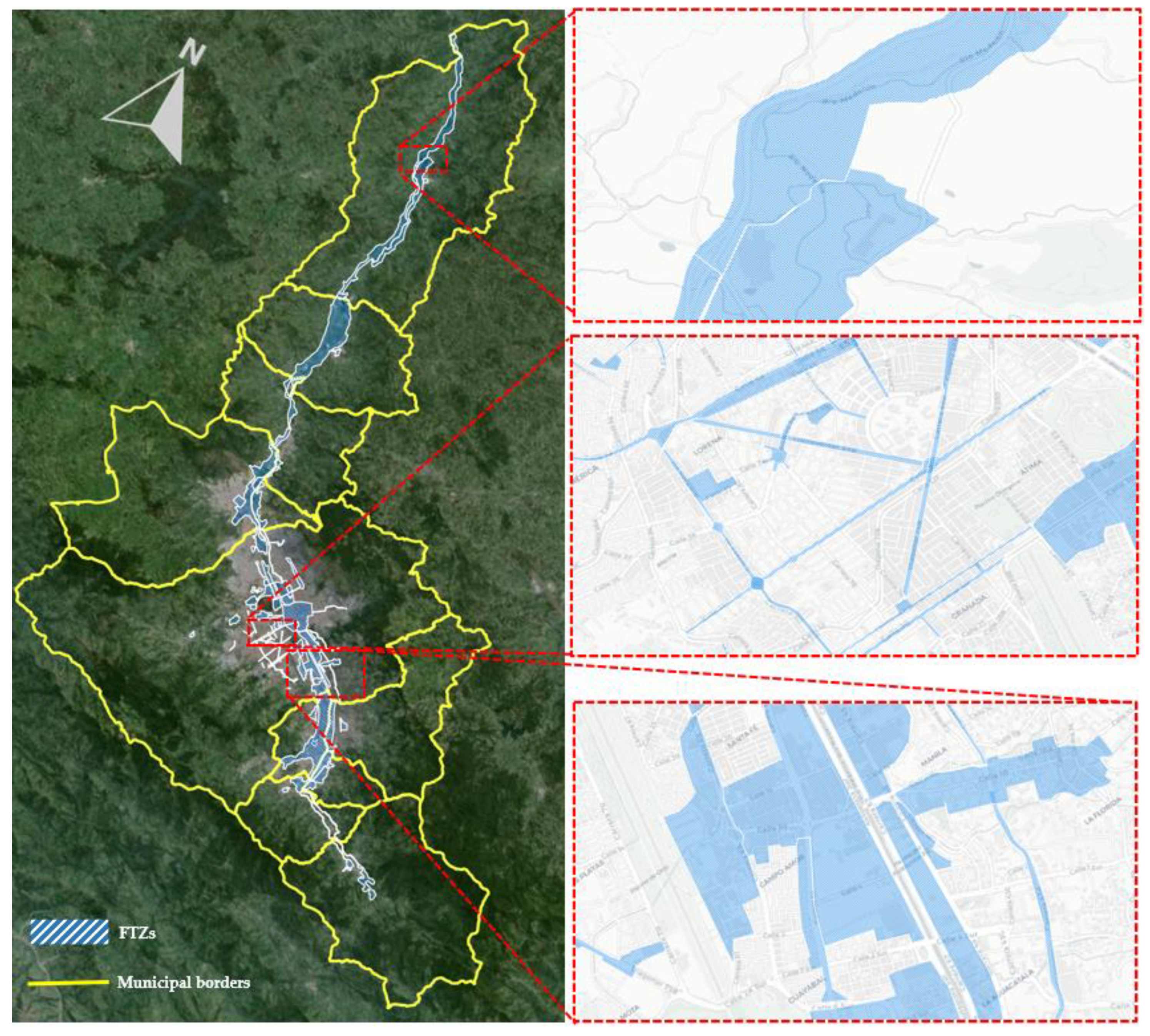
2.4. Application: Case Study of the Aburra Valley, Colombia

Following the methodological framework proposed here, the Metropolitan Area of the Aburra Valley (10 municipalities, 6 of them in conurbation) was studied. A total of 87 FTZs have been systematically identified, quantified, and characterised within the study area. These zones represent significant clusters of economic activity, demarcated and defined by their geographical concentration of companies, as previously outlined. This process included a subsample on-site verification of conditions (as described in Figure 1), enabling the identification of underlying clustering mechanisms or trends, which in turn facilitated the identification of operational zone-based common requirements/qualifications, such as loading/parking infrastructures’ quality and the type of vehicle fleet serving each verified zone.
Descriptive statistics detailing the conditions of the identified FTZs (Table 4) shed light on the distribution of companies in different urban context conditions, showing, for example, clear differences between how SMEs (small and medium enterprises) and large companies tend to form different economic geographies (Table 5).
The spatial cluster analysis allowed for the identification, characterisation, and mapping of the FTZs for the case study. The MAAV is a narrow valley with steep hills, crossed by a river and a national road for through traffic. The land on the lower part of the valley is mostly occupied by large companies, while most of the population lives in higher parts of the hills, showing a historical prioritisation of both land and infrastructure for industrial development and freight transport efficiency and economy. The shape of the valley (long and narrow), the topography, the road infrastructure, and a long history of informal growth to the fringes of the city has meant that most of the outer traffic (both passenger and freight) usually occurs on lower-quality infrastructure. The resulting FTZ clustering is shown in Figure 3.
Figure 4 and Figure 5 further elucidate the statistical relationships among various factors, including establishment types, urban morphology, spatial economic patterns, parking/loading infrastructure availability, and fleet types. These visual representations aim to underscore the potential for implementing UFIs at a zonal level, not only from the private companies’ perspectives but, more importantly, based on the capacity of governments for organising the use of road infrastructure and land use through policies while enhancing land use efficiency. Appendix A presents a subsample of the classification of the 87 FTZs.
The findings for the case study regarding the conditions of clusters show different morphologies for different kinds of companies, which in turn lead to differences observed in the serving freight traffic fleet. In this case, the findings serve to propose a basic matrix for potential implementation for the jurisdictions under review.

3. Discussion

Following the stages outlined in Figure 1, it was observed that the following conditions emerged as a result of the spatial clustering analysis (a detailed description of this is shown in Appendix B):
1.
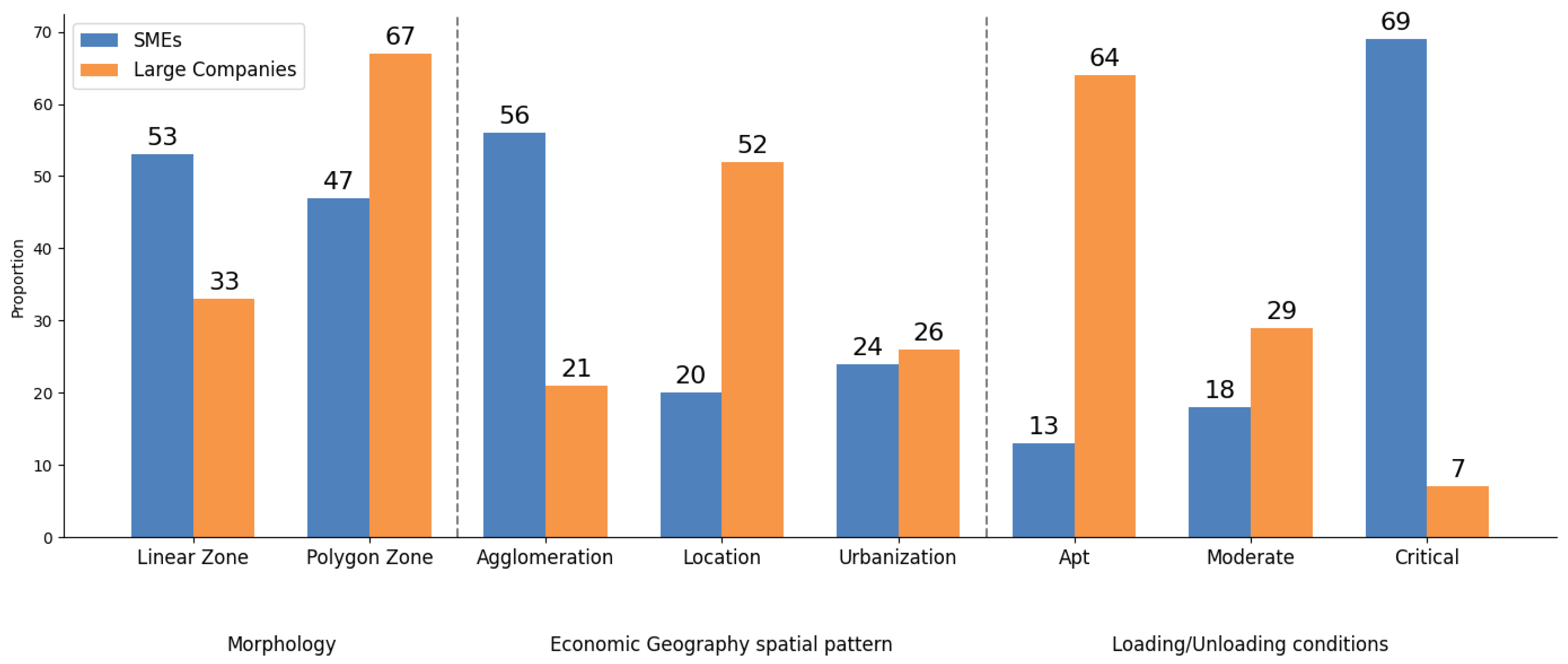
Morphology: The FTZ morphology revealed whether their formation was influenced by specific infrastructures or terrain availability. This insight might inform either land use or infrastructure management decisions. Classifying the morphology into polygonal (one or more blocks) or linear (corridor) categories was highly correlated with the type of fleet serving the companies, as well as with the provision and quality of on-street parking/loading infrastructure.
2.
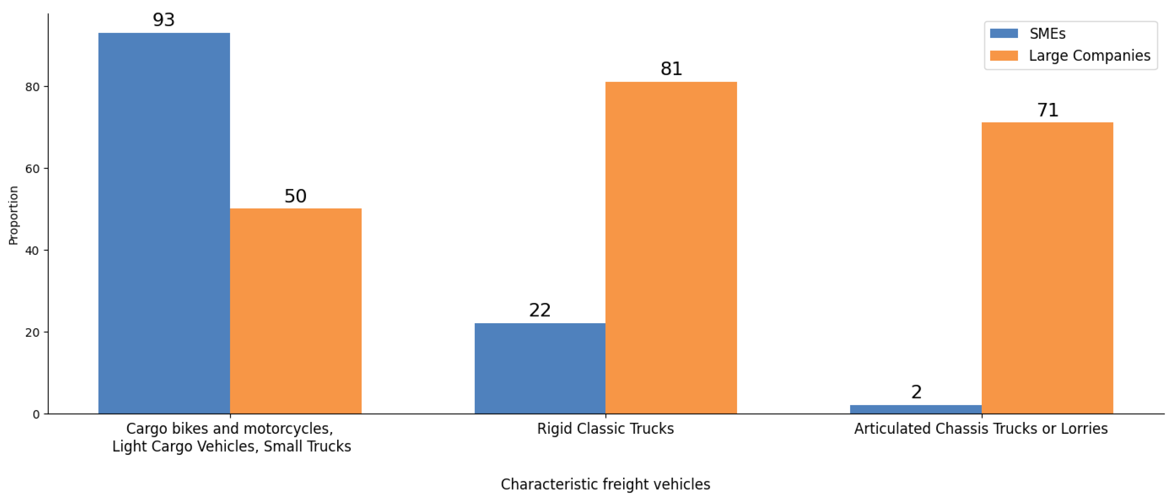
Establishment Type: Whether an FTZ is predominantly formed by large companies or SMEs combined with the transport network, morphology, and economic activity, has been deemed relevant in determining the most suitable freight vehicle types for each zone and for determining if UFIs pertaining noise pollution or conflict with other transport modes are essential.
3.
Loading/Unloading Conditions: By determining the ratio of road offer, its condition, and the demand of each FTZ for freight operations, it was determined that this was practically characterisable under three distinct values:
  • Suitable: Operations confined within company premises, not impeding mobility infrastructure. Low residential density supports unconventional hour strategies and infrastructure management.
  • Moderate: Mixed land use entails variable mobility infrastructure usage. Residential presence necessitates special considerations for unconventional loading/unloading timings.
  • Critical: Extensive use of mobility infrastructure for loading/unloading, highlighting a lack of dedicated facilities and prioritisation for public policy interventions.
4.
Freight Vehicle Types: Traffic counts, field observations, and road safety incidents involving freight fleet, in conjunction with establishment types and mobility infrastructure availability, serve to inform traffic policy, road operations, and UFI zonal deployment, adapted to local urban regulations:
  • Freight bikes and motorcycles, light freight vehicles, and small trucks;
  • Rigid chassis trucks (two or three axles);
  • Articulated chassis trucks or lorries (three or more axles).
These emerging patterns—regardless of the specific values for any potential application to different urban environments—result in valuable information that may serve to unveil the underlying reasons for clustering companies in a way that both governments and the private sector can identify if their agglomeration, location, or urbanisation conditions have been delivering the expected efficiencies at the time that existing policies (for land planning, use, and management, traffic management, road provision, etc.) can be updated or new policies can be implemented to leverage collective benefits, like increasing efficiencies on the freight activities while reducing externalities, such as incidents, congestion, and pollution. What was found for the case study performed as an application of the proposed framework can work for each authority or stakeholder group to prioritise different UFIs; an example of this is presented in Table 6 and Appendix B.

4. Conclusions

The strategic grouping of the UFIs from a government lens highlights planning approaches that span physical, operational, regulatory, and engineering domains. The proposed framework and the results of the case study application may serve stakeholders across the freight transport chain, including governments, authorities, and private entities, in leveraging these strategies for tactical implementation. The proposed approach’s main innovations and contributions include fostering effective government-led, multi-stakeholder engagement and optimisation, using geographic and economic principles as a foundation for freight-related policies, and offering a versatile framework applicable across strategic, tactical, and operational levels. Moreover, this approach facilitates the identification of opportunities to mitigate externalities in freight transport by advocating for zonal enhancements across infrastructure, technology/fleets, and operational/regulatory strategies.
Freight transport planning is inherently complex due to the distinct nature of freight activities and the strategic location choices made by companies within urban infrastructure networks. Previous attempts to model the freight transport system have often lacked a holistic perspective, missing the benefits of a multi-stakeholder approach, as well as an evaluation of the spatial and economic nature for companies’ locations, and therefore, freight O-Ds and the integration of both quantitative and qualitative analyses. This study emphasises the need for a decision-making framework that captures the spatial aggregation of freight-dependent facilities and proposes effective integration measures for urban and transport planning.
Spatial and economic geography analyses underpin the establishment of FTZs, employing GIS tools, spatial analysis techniques, and field inspections to identify pivotal variables that influence the functionality of each zone. With 87 FTZs recognised in the MAAV case study, the diverse of potential implementation strategies that can be adapted is shown:
  • Spatially, integrating freight into urban planning processes for both new developments and existing urban settings.
  • Operationally, enhancing the use of existing infrastructure and adapting to the specific needs introduced by UFIs.
  • From a private sector perspective, optimising operations through a collaborative zonal approach.
The proposed zoning system is versatile, offering tools for single-variable analysis, multivariate statistical methods, and modelling approaches to consider various temporal and spatial scenarios. This flexibility allows for addressing urban challenges, such as congestion, pollution, and inefficiency, both reactively and proactively.
This study’s zonal perspective is particularly powerful, optimising efforts and resources across multiple stakeholders, and thereby maximising the impact of initiatives. This systems-thinking approach aligns the dynamics of public space, urban development, and city logistics, creating a symbiotic relationship between the freight transport system and the urban fabric.
While this study presents a comprehensive yet practical framework for urban freight planning, it is not without limitations. The identification and analysis of FTZs is based on current urban and economic configurations, which may evolve; for this, a “ways forward” component has been included in the methodology outline. Additionally, the scalability of this framework to other urban contexts and its adaptability to future technological advancements and policy changes remain areas for further exploration.
As potential for further research, this paper sets the stage for computational analysis of future scenarios in policy implementation, considering urban and economic variables. This is particularly useful for cities or metropolitan regions that have or are developing system-wide, data-based freight models—a missing condition in the case study developed here. It opens avenues for further research to explore the potential of multi-stakeholder joint planning for economic, social, and environmental advancement. Future studies may use this framework to examine the broader urban or regional impact of freight dynamics, including cross-sectorial land use analysis, infrastructure network optimisation, and the pursuit of urban sustainability. Thus, the approach not only proposes a new systemic thinking framework but also presents significant possibilities for optimising resources, including land, capital investments, and operational expenditures.

Author Contributions

Conceptualisation, H.B.-J. and J.P.-J.; methodology, H.B.-J. and J.P.-J.; software, H.B.-J.; validation, J.P.-J.; formal analysis, H.B.-J. and J.P.-J.; investigation, H.B.-J.; resources, H.B.-J. and J.P.-J.; data curation, H.B.-J. and J.P.-J.; writing—original draft preparation, H.B.-J.; writing—review and editing, J.P.-J.; visualisation, H.B.-J.; supervision, J.P.-J.; project administration, H.B.-J. and J.P.-J. All authors have read and agreed to the published version of the manuscript.

Funding

This research received no external funding.

Data Availability Statement

The data presented in this study are available in “Datos Abiertos Area Metropolitana del Valle de Aburra” and “GeoMedellin” opendata portals. These data were derived from the following resources available in the public domain: https://datosabiertos.metropol.gov.co/, https://www.medellin.gov.co/geomedellin/datosAbiertos.

Conflicts of Interest

The authors declare no conflicts of interest.

Appendix A. Subsample of the Case Study FTZs

CodeCityMain Mobility Network InfrastructuresEconomic ActivityZone Morphology Freight Transport Vehicle Type
ABCEconomic GeographyISIC (V4) TypeShapeArea (ha)Area (km2)RemarksEstablishment TypeLoading/Unloading ConditionsCargo Bikes and Motorcycles, Light Cargo Vehicles, Small TrucksRigid Chassis TrucksArticulated Chassis Trucks or Lorries
1BarbosaCl 13 AgglomerationGPolygonal9.160.09 SMEsCriticalYesYesNo
2BarbosaAutopista NorteAutopista al Rio Magdalena 1 LocationCLinear435.004.35Redevelopment ZoneLarge CompaniesAptNoYesYes
3BarbosaHatillo-Barbosa LocationCLinear375.003.75Redevelopment ZoneLarge CompaniesAptNoYesYes
4BarbosaHatillo-Barbosa LocationCLinear339.003.39Redevelopment ZoneLarge CompaniesAptNoYesYes
5BelloCl 46Cl 50Cra 59AgglomerationGPolygonal45.000.45 SMEsCriticalYesNoNo

Appendix B. Emerging Conditions and Proposed UFIs Implementation for the Presented Case Study

Zoning VariablesVariable ValueUFIs with Potential for Zonal ImplementationDescription
MorphologyPolygonalIM, PLAM, TM, PIT, SE, LM, FDLUMCompanies/facilities located in polygonal groups as blocks of the urban fabric or private enclosed circuits can approach common needs and possibilities regarding that urban form through zonal implementation of infrastructure, land use, and operational and normative nature initiatives.
LinearIM, PLAM, VRS, TM, PIT, SE, LM, FDLUMCompanies/facilities located in linear grouping patterns as major roadways, alongside economic corridors, or alongside major infrastructures as hydraulic canals can benefit from the zonal implementation of specific infrastructure, land use, and operational and normative nature initiatives.
Establishment TypeSMEsPLAM, VRS, TM, PIT, LM, FDLUMFreight-intensive zones formed by the grouping of SMEs have particular potential for the implementation of initiatives serving specific conditions, giving SMEs a reduction of “transaction costs” within the area and between the various specialised production units and freight activities, a value increase in local production practices, the possibility for reduction of operative costs derived from fleets operations, the need for large and subtilised facilities as parking lots, etc.
Large companiesIM, VRS, TM, SE, PIT, LM, FDLUMFreight-intensive zones formed by the grouping of large companies can be approached and can obtain benefits from initiatives regarding high standards of productivity, such as major infrastructure improvements, freight committees, certification programs, preference in the use of infrastructure, tributary incentives for the acquisition of freight fleets, etc.
Freight transport vehicle TypeCargo bikes and motorcycles, light cargo vehicles, small trucksIM, PLAM, VRS, TM, PIT, LMEver-growing trends on the research and practice of sustainable mobility have made the appearance of innovations in the use of vehicles that have been in the urban scenario for decades have just recently been considered options with potential for diversified uses in the freight transport system. Light-weight vehicles provide great opportunities but also impose great challenges on how to fully integrate them into the system. Specific ITS, adapted infrastructures, and the possibility/need for sharing pedestrian space provides an opportunity for the zonal application of light-weight vehicle use at the zonal level.
Rigid chassis trucksIM, PLAM, VRS, SE, TM, PIT, LM, FDLUMThe most traditional urban cargo distribution vehicle in most city contexts is the two- or three-axis rigid chassis truck; most of the infrastructure on dense, mixed-use urban land is adapted to this type of vehicle and may even have been built to satisfy its operational needs. Therefore, the zones heavily dependent on this type of fleet (e.g., industrial zones within city limits) present the most opportunities for infrastructure and operational upgrades for the implementation of zonal freight initiatives.
Articulated chassis trucks or lorriesIM, PLAM, VRS, SE, TM, PIT, LM, FDLUMThe larger options for urban freight transport vehicles fleets are usually three- to five-axis articulated trucks or lorries (depending on local weight and size restrictions). The size and operational needs of this type of vehicle usually call for exclusive infrastructure and road geometric design with rural roads standards in urban settings, so considering which zones of the city are heavily dependent on this type of vehicle calls for specific city logistics implementation conditions at the zonal level.

References

  1. Herce Vallejo, M. Infraestructuras y Medio Ambiente I: Urbanismo, Territorio y Redes de Servicios; Editorial UOC S.L.: Barcelona, Spain, 2010. [Google Scholar]
  2. Grünig, M. Sustainable urban transport planning. In Metropolitan Sustainability; Woodhead Publishing: Cambridge, UK, 2012; pp. 607–624. [Google Scholar] [CrossRef]
  3. Williams, K. Spatial Planning, Urban Form and Sustainable Transport: An Introduction; Routledge: London, UK, 2005. [Google Scholar]
  4. De Ortúzar, J.D.; Willumsen, L.G. Modelling Transport; John Wiley and Sons: Hoboken, NJ, USA, 2011; ISBN 9780470760390. [Google Scholar]
  5. Transport for London. Traffic Modelling Guidelines; Transport for London: London, UK, 2021. [Google Scholar]
  6. Aloulou, F. The Application of Discrete Choice Models in Transport. In Statistics—Growing Data Sets and Growing Demand for Statistics; InTech Open: London, UK, 2018. [Google Scholar]
  7. Aljohani, K.; Thompson, R.G. A Multi-Criteria Spatial Evaluation Framework to Optimise the Siting of Freight Consolidation Facilities in Inner-City Areas. Transp. Res. Part A Policy Pract. 2020, 138, 51–69. [Google Scholar] [CrossRef]
  8. Yazdani, M.; Pamucar, D.; Chatterjee, P.; Chakraborty, S. Development of a Decision Support Framework for Sustainable Freight Transport System Evaluation Using Rough Numbers. Int. J. Prod. Res. 2019, 58, 4325–4351. [Google Scholar] [CrossRef]
  9. Tao, X.; Zhu, L. Meta-Analysis of Value of Time in Freight Transportation: A Comprehensive Review Based on Discrete Choice Models. Transp. Res. Part A Policy Pract. 2020, 138, 213–233. [Google Scholar] [CrossRef]
  10. Harris, G.A.; Anderson, M.D.; Farrington, P.A.; Schoening, N.C.; Swain, J.J.; Sharma, N.S. Developing Freight Analysis Zones at a State Level: A Cluster Analysis Approach. J. Transp. Res. Forum 2010, 49, 59–68. [Google Scholar] [CrossRef]
  11. Ducret, R.; Diziain, D.; Plantier, T. Proposal for an Evaluation Grid for Analysing Local Public Urban Freight Policies: Strengths, Weaknesses and Opportunities for French Cities. Transp. Res. Procedia 2016, 12, 105–118. [Google Scholar] [CrossRef]
  12. Sun, M.; Wong, D.W.S. Spatial Aggregation as a Means to Improve Attribute Reliability. Comput. Environ. Urban. Syst. 2017, 65, 15–27. [Google Scholar] [CrossRef]
  13. Fleming, D.K.; Hayuth, Y. Spatial Characteristics of Transportation Hubs: Centrality and Intermediacy. J. Transp. Geogr. 1994, 2, 3–18. [Google Scholar] [CrossRef]
  14. Toilier, F.; Serouge, M.; Routhier, J.L.; Patier, D.; Gardrat, M. How Can Urban Goods Movements Be Surveyed in a Megacity? The Case of the Paris Region. Transp. Res. Procedia 2016, 12, 570–583. [Google Scholar] [CrossRef]
  15. Sakai, T.; Kawamura, K.; Hyodo, T. Spatial Reorganization of Urban Logistics System and Its Impacts: Case of Tokyo. J. Transp. Geogr. 2017, 60, 110–118. [Google Scholar] [CrossRef]
  16. Gayialis, S.P.; Kechagias, E.P.; Konstantakopoulos, G.D. A City Logistics System for Freight Transportation: Integrating Information Technology and Operational Research. Oper. Res. 2022, 22, 5953–5982. [Google Scholar] [CrossRef]
  17. Using Digitalisation for Data-Driven Freight Curbside Management: A Perspective from Urban Transport Planning—ProQuest. Available online: https://www.proquest.com/openview/bbd92bb01cb553e82880328b5ad5ad22/1?pq-origsite=gscholar&cbl=2026366&diss=y (accessed on 4 April 2024).
  18. Aszyk, A.; Bednarczyk, M.; Marcinkowski, B.; Pisarski, P.; Puzniakowski, T. Towards Optimal Freight Selection Strategies in Transport Planning. Procedia Comput. Sci. 2023, 225, 218–227. [Google Scholar] [CrossRef]
  19. Russo, F.; Comi, A. Overview of Urban Freight Transport Planning and European Suggestions. In Handbook on City Logistics and Urban Freight; Edward Elgar Publishing: Cheltenham, UK, 2023; pp. 225–245. [Google Scholar] [CrossRef]
  20. Marcucci, E.; Gatta, V.; Le Pira, M. Handbook on City Logistics and Urban Freight. In Handbook on City Logistics and Urban Freight; Edward Elgar Publishing: Cheltenham, UK, 2023; pp. 1–498. [Google Scholar] [CrossRef]
  21. Cherrett, T.; Allen, J.; McLeod, F.; Maynard, S.; Hickford, A.; Browne, M. Understanding Urban Freight Activity—Key Issues for Freight Planning. J. Transp. Geogr. 2012, 24, 22–32. [Google Scholar] [CrossRef]
  22. Sánchez-Díaz, I. Modeling Urban Freight Generation: A Study of Commercial Establishments’ Freight Needs. Transp. Res. Part A Policy Pract. 2017, 102, 3–17. [Google Scholar] [CrossRef]
  23. Gonzalez-Feliu, J.; Peris-Pla, C. Impacts of Retailing Land Use on Both Retailing Deliveries and Shopping Trips: Modelling Framework and Decision Support System. IFAC-Pap. 2018, 51, 606–611. [Google Scholar] [CrossRef]
  24. Barron, L.; Ruggieri, D.; Branas, C. Assessing Vulnerability to Heat: A Geospatial Analysis for the City of Philadelphia. Urban. Sci. 2018, 2, 38. [Google Scholar] [CrossRef]
  25. Sahu, P.K.; Chandra, A.; Pani, A.; Majumdar, B.B. Designing Freight Traffic Analysis Zones for Metropolitan Areas: Identification of Optimal Scale for Macro-Level Freight Travel Analysis. Transp. Plan. Technol. 2020, 43, 620–637. [Google Scholar] [CrossRef]
  26. Área Metropolitana del Valle de Aburrá Encuesta Origen-Destino de Hogares y de Carga Para El Valle De Aburrá; 2012. Available online: https://www.metropol.gov.co/observatorio/Paginas/encuestaorigendestino.aspx (accessed on 22 March 2020).
  27. Jiang, Z.; Lei, L.; Zhang, J.; Wang, C.; Ye, S. Spatio-Temporal Evolution and Location Factors of Port and Shipping Service Enterprises: A Case Study of the Yangtze River Delta. J. Transp. Geogr. 2023, 106, 103515. [Google Scholar] [CrossRef]
  28. Jiang, Y.; Zhang, J. The Effects of a Cross-Border Freight Railway Project on Chinese Cities’ Green Innovation Intensity: A Quasi-Natural Experiment Based on the Expansion of the China Railway Express. Sustainability 2023, 15, 11707. [Google Scholar] [CrossRef]
  29. Liang, J.; Xie, S.; Bao, J. Analysis of a Multiple Traffic Flow Network’s Spatial Organization Pattern Recognition Based on a Network Map. Sustainability 2024, 16, 1300. [Google Scholar] [CrossRef]
  30. National Cooperative Freight Research Program. Improving Freight System Performance in Metropolitan Areas: A Planning Guide; National Cooperative Freight Research Program: Gainesville, FL, USA, 2015. [Google Scholar]
Figure 1. Methodology outline.
Urbansci 08 00030 g001
Figure 2. GIS-based spatial cluster analysis.
Urbansci 08 00030 g002
Figure 3. FTZ mapping for the MAAV case study.
Urbansci 08 00030 g003
Figure 4. Relationship between establishment types of the case study FTZs and their morphology, economic geography spatial pattern, and loading/unloading conditions.
Urbansci 08 00030 g004
Figure 5. Relationship between the establishment types of the case study FTZs and the fleet type as per traffic counts in each zone. For SMEs or large companies, the sum of their fleet type proportion is greater than 100% due to the simultaneous need for diverse types of fleets for different FTZs.
Urbansci 08 00030 g005
Table 1. Data used for spatial cluster analysis.
Road Infrastructure
(By Segment)
Land Use (By Polygon) *Economic Geography
(By Companies per Polygon)
VariableLocationLocationLocation
Section width (m)ClassificationClassification
Roadway width (m)Mix (type and level)ISIC reference **
Sector ***
Slope (°)Topography
ClassificationUse
ConditionLots and blocks
HierarchyLot shape
Public transport
Collisions
* As per each city’s Planning Schemes and Ordinances. ** The International Standard Industrial Classification of All Economic Activities (ISIC), as a proxy value for the freight intensity of each company. *** As per the three-sector model. A detailed mapping endeavour was undertaken using open-source QGIS®, encompassing the entire region of interest.
Table 2. UFI clustering using a high-level planning approach from a zonal perspective.
Strategic/Planning Cluster for Zonal Use of UFIs Based on Principles of Economic Geography for the Proposed Zoning ApproachGroups of Urban Freight Initiatives [30]
Infrastructure development/land useInfrastructure management (IM)Freight demand/land use management (FDLUM)
Parking/loading areas management (PLAM)Stakeholder engagement (SE)
Fleet (vehicles and technologies)Vehicle-related strategies (VRS)Stakeholder engagement (SE)
Traffic management (TM)
Operational/regulatoryInfrastructure management (IM)Pricing, incentives, and taxation (PIT)
Parking/loading areas management (PLAM)Logistical management (LM)
Vehicle-related strategies (VRS)Freight demand/land use management (FDLUM)
Traffic management (TM)Stakeholder engagement (SE)
Table 3. UFI assignment to each FTZ type.
FTZ Type (as per Its Economic Geography Classification)UFIs with Potential for Zonal ImplementationDescription
Location economiesIM, PLAM, VRS, SE, PIT, LMFor zones with shared same-industry practices and benefits derived from shared suppliers or clients can make stakeholders within a location economy zone agree on common needs and potential for infrastructure improvements and operational upgraded systems that will help the zone and reduce individual investments needs.
Urbanisation economiesIM, PLAM, TM, SE, LM, FDLUMZones with shared infrastructure and service dependency (regardless of which sector they belong to) can make stakeholders within an urbanisation economy agree on the need for improving infrastructure and land use-related strategies as a group/zone.
Agglomeration economiesIM, PLAM, TM, LM, FDLUMZones within a shared urban and economic setting can make stakeholders within an agglomeration economy zone agree on the need for planning, from a zonal perspective, regarding infrastructure development, land use, and normative approaches to operative needs.
Table 4. Descriptive statistics of case study FTZs.
MunicipalityIdentified FTZ per MunicipalityFTZ Area per Municipality (ha)FTZ Weighted Area
Barbosa41158.165.6%
Bello4655.104.6%
Caldas5162.981.2%
Copacabana4224.903.2%
Envigado3181.052.2%
Girardota2845.5010.6%
Itagüí3657.9031.1%
La Estrella4131.403.7%
Medellín541858.964.9%
Sabaneta4218.3013.9%
Table 5. Basic statistical analysis for the identified FTZs: Proportions of urban/economic variables.
CharacteristicsFTZProportion
MorphologyPolygonal4956.30%
Linear3843.70%
Establishment typeSMEs4551.70%
Large Companies4248.30%
Economic geography spatial patternAgglomeration3439.10%
Location3135.60%
Urbanisation2225.30%
Table 6. UFI implementation potential at the zonal level for the case study.
ConditionValueUFI with Greater Potential of Implementation
MorphologyPolygonal
  • Ring roads
  • Improved staging areas
  • Vehicle size and weight restrictions
  • Taxation
  • Freight quality partnerships
  • Vertical height
  • Relocation of large traffic generators
Linear
  • Acceleration/deceleration lanes
  • Peak-hour clearways
  • Low-noise delivery
  • Exclusive truck lanes
  • Staggered work hours program
  • Operational incentives for low emission vehicles
  • Freight advisory committee
  • Time slotting of pick-up and deliveries
Establishment typeSMEs
  • Parking and loading zones (in public space)
  • Low-noise delivery
  • Low-emission zones
  • Taxation
  • Urban consolidation centres
  • Receiver-led delivery consolidation program
Large companies
  • New upgraded infrastructure
  • Intermodal terminals
  • Emission standards
  • Dynamic routing
  • Load factor restrictions
  • Freight advisory committee
  • Recognition programs
  • Relocation of large traffic generators
Freight transport vehicle typeCargo bikes and motorcycles, light cargo vehicles, small trucks
  • Ramps for handcrafts and forklifts
  • Freight parking and loading zones
  • Urban consolidation centres
  • Low-emission zones
  • Operational incentives for electric/low-emission vehicles
  • Low-noise delivery
Rigid chassis trucks
  • Intermodal terminals
  • Improved staging areas
  • Emission standards
  • Technical advisory committee
  • Truck routes
  • Road pricing
  • Dynamic routing
  • Receiver-led delivery
Articulated chassis trucks or lorries
  • Removal of geometric constraints at intersections
  • Truck stops
  • Emission standards
  • Load factor restrictions
  • Road pricing
  • Vertical height detection systems
  • Freight quality partnerships
  • Relocation of large traffic generators
Disclaimer/Publisher’s Note: The statements, opinions and data contained in all publications are solely those of the individual author(s) and contributor(s) and not of MDPI and/or the editor(s). MDPI and/or the editor(s) disclaim responsibility for any injury to people or property resulting from any ideas, methods, instructions or products referred to in the content.

