Abstract
The increases in both the elderly population and urbanization present new problems for planning new cities and managing old cities. To solve this challenge, innovative ideas/proposals that encourage walkability and reduce fossil energy motor transport are needed, in line with the actions advocated by Sustainable Development Goal #11 (SDG11), Sustainable Cities and Communities. Opening passages that cross blocks, creating connections between the streets, is the proposal discussed in this paper, as seen in cities like Paris, Prague, Milan, and Juíz de Fora, which have passages in their urban fabric. These can be implemented in a building’s rehabilitation or when a new building replaces it. New architectural project designs should have several characteristics that promote walkability in the city, including passages and galleries. Although previous research has obtained promising results, extending the research to different urban fabrics and block sizes is needed. Using space syntax and data analysis, we simulated and quantitatively assessed the walkability of three neighborhoods in Lisbon, Portugal. The comparison of all simulations and the discussion of the results show that the passages improve walkability. It is also noticeable that there is higher walkability in orthogonal urban fabrics than in non-orthogonal fabrics. The results for block size are inconclusive.
1. Introduction
Most contemporary cities in the Western world struggle with reduced and decreasing walkability for their citizens, especially the most vulnerable. While the planning of new cities or new urban areas benefits from anticipated concerns about growing walkability needs and, considering current knowledge, can promote the implementation of urban solutions that guarantee this increase, older and more consolidated cities that were unable to foresee that this problem would affect them must devise innovative proposals [1] to respond to this challenge. In this sense, promoting walkability (ease and comfort with which people can walk within a given area [2]) involves space syntax (solid scientific method that consists of calculating spatial relationships in the built environment, allowing to analyze and understand how it functions both spatially and socially [3], enhancing connectivity and permeability (ease linkage and movement between different parts of an urban area), prioritizing pedestrian mobility (the ability of individuals to move within a city or region [4]), ensuring safe passages (physical pathways, corridors or galleries that connect different spaces within a city [2]), and addressing the needs of vulnerable road users (individuals more susceptible to accidents and injuries due to their exposure to traffic [2]). These concepts intersect to shape urban environments that promote health, sustainability, and community well-being.
The growth of the Portuguese elderly population in recent decades (from less than 1.5 million in 1991 to more than 2.2 million in 2019 [5]), combined with the increased rate of population aging—which will almost double, going from the current 159 to 300 elderly people for every 100 young people by 2080 [5]—are issues that should concern contemporary Portuguese society. These trends and concerns are not exclusively national [6,7], and as “it is a culture’s duty to take care of its elderly” [8], the WHO (World Health Organization) declared the decade of 2021–2030 as the Decade of Healthy Aging [9]. Although the INE (Portuguese Statistics Institute) [5] predicts a decrease in the young population, this is also a vulnerable age group [10], which is not neglected in the solution proposed in this paper. The opening of the passages provides several benefits for the overall population, particularly for these vulnerable groups, as it encourages the occupation of spaces inside the blocks (Figure 1). These benefits include protection against heat/cold, noise, and air pollution, especially for the most vulnerable population; greater shading and lower extreme temperatures; pedestrian areas without motorized vehicles; spaces for socializing and leisure, especially for the most vulnerable population; spaces for children to play in a safe environment; contact with local fauna and flora; and intergenerational living, reducing elderly isolation.
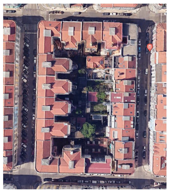
Figure 1.
Detail of space inside the block.
To work toward SDG11 (Sustainable Development Goal #11), and given the aging population in old cities, it is imperative to propose solutions [1] that promote walkability and reduce the use of fossil energy motor transport. Hillier [11] previously argued that a city should be lived by pedestrians, enhancing the public space and its relationship with buildings [12].
Currently, urban research suggests that the renewal of cities should avoid barriers and increase the prevalence of open spaces, facilitating permeability for walking for periods of up to 15–20 min, called “hyper-connectivity” or “chrono-urbanism”, as defined by [13,14] and supported by [10,15,16,17].
Following previous research [18,19], and inspired by the network building concept, the idea emerges of creating passages that open closed blocks, increasing pedestrian permeability, as seen in cities like Paris, France; Prague, Czech Republic; Milan, Italy; and Juíz de Fora, Brazil, which use this concept in their urban fabrics. Schematically, Figure 2 shows an urban fabric with several blocks (Figure 2a) and the same blocks with open passages, with noticeable changes in the allowable paths (Figure 2b).
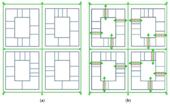
Figure 2.
Schematic depiction of opening passages through closed blocks [20]: (a) paths allowed before opening passages (green arrows); (b) paths allowed (green arrows) after opening passages (red dotted lines).
The revitalization of empty and/or abandoned spaces is at the core of this proposal, which is where the passages would be opened. During a building’s rehabilitation or its replacement with a new one, it is essential to consider these solutions, which include buildings that contribute to facilitating walkability or at least that do not reduce it [20].
Scientifically grounded spatial analysis tools have an active role in assessing the functioning of a neighborhood. Namely, the space syntax method supports the urban design, planning, and refurbishment of cities and neighborhoods [3], strengthening research about the built environment’s spatial properties. These tools’ ongoing development, in line with Heraclitus ‘panta rhei’ (everything flows), emerges from the merging of natural, technical, and social sciences and contributes to theories of the built environment [3]. Space syntax evolution requires interconnection not only among several cultural contexts but also among different scientific fields, such as anthropology, cognitive sciences, applied mathematics, and computing, as well as philosophical issues. On one hand, this method allows for identifying revitalization opportunities to be included in new proposals according to the existing urban areas spatial potentials and assessing the liveliness of urban centers because of new passages added [3]. On the other hand, it can also give warnings of the future socio-economic impacts of the proposed urban design alternatives [3].
Harmonized interactions between the city environment (urban and architectural) and the social matrix result from the establishment of guidelines, achieved by the relationship between the city scale and the applied sociological codes [21].
Depending on people’s sense of living in urban places, a city’s uses will be defined, and interconnections will be created. Building design is essential [12] for urban planning and changing public space uses [16,22].
Combining movement, land use, and behavior factors, the space syntax method relates each space to all others, in terms of changes in direction and angular deviation [23,24], focusing on the relationship between increased walkability and the openness of passages in the urban fabric.
In particular, the aim of the exploratory analysis was to assess the permeability and improvement in spatial structures as more passages were opened.
To achieve this goal, an approach methodology was defined, which is outlined in Figure 3. It consists of a literature review of two main themes—space syntax and graph theory. After intensive fieldwork to identify potential passage locations, a segment map is constructed. This map is submitted to the calculation software, and the obtained results are analyzed and discussed.
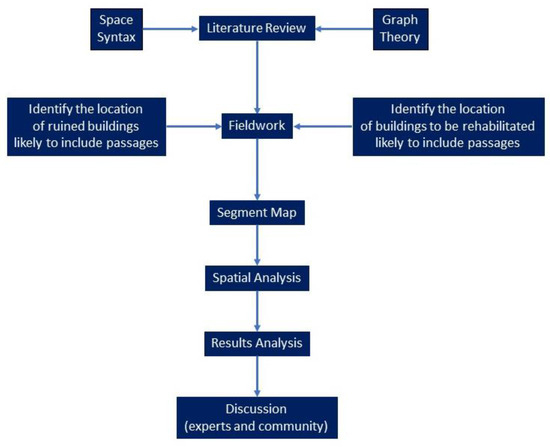
Figure 3.
Methodology flowchart.
It is also intended to expand the study to other neighborhoods of Lisbon (the old city) with diversified urban fabrics, following the research work carried out in [20].
This paper is structured into seven sections. Following this introduction, the Section 2 presents the theoretical background, the Section 3 offers a comprehensive case study description, and the Section 4 presents the materials and methods used. The Section 5 and Section 6 present the results and their discussion, respectively, while the Section 7 offers concluding remarks on the research.
2. Theoretic Background
Consolidated cities, which include most Portuguese ones, have complex morphological–demographic–socio-economic characteristics resulting from their growth and development process, pointing to an urgent need to rethink and reimagine them [1] and changing the way of life of the (world) population. Although Otto, in [1], refers to new cities when defining this need as a “planning revolution”, it does not prevent the same need from being extended to consolidated cities. She adds a paradigm shift in creating and planning cities, complemented by a holistic strategy [25] of building “compact cities strategically structured with neighborhoods and mixed-use buildings and with an emphasis on integrated urban systems” [1].
This strategy includes increasing mobility [26] and connectivity [27,28] in consolidated cities. Choay [29] criticizes urban design based only on rationalist models imported from the modern period, arguing that cities should be more humanistic and less theoretical, valuing integration, mobility, and the use of public space. Architecture should not create walls or physical limitations or obstruct movement [30]. Also, from a sociological point of view, Ascher [23] studied urban mobility, the dynamics of life, and the urbanization of modern cities and concluded that they are essential for cities to become alive and dynamic. Monofunctional and dispersed cities, criticized by Alexander [31], have led to the introduction of innovative ideas into the conceptual processes of urban design (e.g., [32]).
Furthermore, the current discussion and research on air quality and climate change (urban areas produce 70% of harmful emissions [1]), as well as the recent constraints brought about by the 2019 pandemic, have placed walkability in a prominent place in sustainable urban planning [2], making it increasingly mandatory for neighborhoods in metropolitan areas to be walkable, especially for the most vulnerable populations [10].
Entities like UN-Habitat (United Nations Human Settlements Programme) and ITDP (Institute for Transportation and Development Policy) [33] advocate for the creation of slimmer pedestrian networks in large blocks, prioritizing connectivity, in line with [34,35]. This article goes further, expanding this opportunity to other urban fabrics (smaller, orthogonal, and non-orthogonal) by adding permeability.
Several spatial models have been widely used [28,36], combined or not with GIS [37] and multivariate analysis techniques [38,39,40,41,42,43,44]. Recently, urban studies have examined walkability using a wide range of variables of a diverse nature [45], e.g., geometric, functional, social [28], environmental [38], etc., which translate into pedestrian flow indicators [3], attractiveness [37], usability [28], comfort, safety, quality [39], etc. They have generally used graph theory and, above all, the space syntax method [3,46,47,48] in particular. Graph theory allows for a structural analysis of urban networks, which serve as the basis for the space syntax method. The latter assesses the accessibility of urban spaces, allowing for an understanding of pedestrian movement and interactions with the city, to better plan the urban network and improve walkability. It is important to remain mindful of the oversimplification of reality that these models imply and to always understand some subjectivity when interpreting the results. Furthermore, when emphasizing both connectivity and permeability, it is essential to not neglect the quality of the public space, safety, or comfort.
In the space syntax method, to compare the “before” and “after” changes introduced in the urban fabric, the theory of natural movement is used [15,47]. This theory states that the natural flow of movement in built environments depends on the spatial integration of the street network, that is, the distance from one point to all points. Thus, the greater the spatial integration, the greater the natural flow of movement at all scales [47].
Currently, the axial map has been replaced by angular segment analysis using distance measures [23,48,49], as it focuses on the angles of intersecting streets and their spatial arrangements and calculates the distances between segments, allowing for the assessment of the overall urban flow. This operational issue can be resolved with the DepthmapX software, version 0.80 (https://www.spacesyntax.online/software-and-manuals/depthmap/ (accessed on 18 April 2022)). The space syntax method examines the relationships between each public space or street segment within a constructed urban environment and all other public spaces.
According to [21,50], this method shows that measures to capture spatial structures optimally are the to-movement and the through-movement potentials. The to-movement, or closeness, measures the probability of a street being an attractor space. The through-movement, or betweenness, measures the probability that a street is used as part of a route, i.e., the shortest path from each point to all other points. Hence, the defined movements represent several accessibility potentials and are best predicted by integration and choice measures [51].
These two measures allow simulating scenarios in the study area, before and after the opening of the passages, as well as their comparison.
3. Case Study
At the beginning of the last century, Lisbon grew toward the northeastern rural area. The built neighborhoods are mainly orthogonal or semi-orthogonal. The three neighborhoods, named N1, N2, and N3, selected to test the influence of the passages, are currently located at the center of the city and are shown in Figure 4.
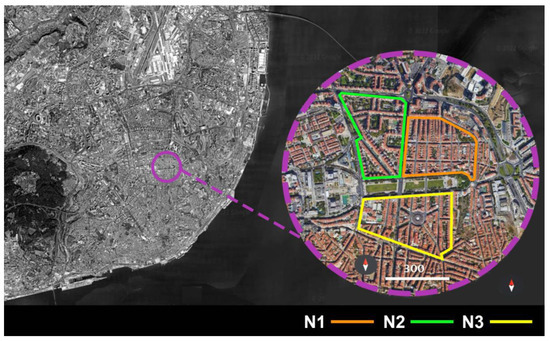
Figure 4.
Location of the three neighborhoods in Lisbon, Portugal.
These three neighborhoods are crossed by two perpendicular road axes—the structural Almirante Reis Avenue in the N-S direction and D. Afonso Henriques Avenue in the W-E direction. In general terms, an orthogonal urban fabric defines neighborhoods N1 and N3. There are medium-sized blocks in N1 and small-sized blocks in N3 (orange and yellow lines, respectively, in Figure 4). A non-orthogonal urban fabric with large blocks characterizes neighborhood N2 (green line in Figure 4).
In these buildings, there are often some places, predominantly on the ground floor, that can be replaced by passages to the interior of the blocks without requiring extensive work.
By carrying out extensive fieldwork in the neighborhoods described above, it was possible to classify the places into several categories, such as vacant stores, private passages, buildings under construction, and abandoned and ruined buildings. These marked places were spots for passage openings in study development, thus establishing more connections between the current streets and increasing walkability.
These spaces were identified in manually generated maps, and passages were opened in the buildings to the interior of the blocks, creating more movement possibilities inside the neighborhoods.
This area’s urban fabric and its use have the potential to ensure safe, inclusive, and resilient mobility and to create attractiveness and well-being for the resident citizens and visitors. This is aligned with the strategic pillar of “More Innovation”, as defined by the Municipality of Lisbon, which states, “To make Lisbon a pioneering and testing city for innovative mobility solutions in real but controlled environments, generating a positive impact both on the economy and users” [52].
4. Materials and Methods
Considering the study area described above, different simulations were computed using the space syntax method, and maps were manually generated.
Taking into account the proportions of the three neighborhoods for the current scenario (without passages), a buffer area of 1000 m (15/20 min walking time), was considered to reduce the impact of edge effects (Figure 5).
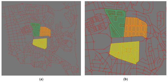
Figure 5.
Axial map (red lines) and three neighborhoods: N1 (orange area), N2 (green area), and N3 (yellow area). (a) Study and buffer area; (b) zoom in on the study area.
The study area axial map, which includes the three neighborhoods, was converted into a segment map using DepthmapX software (version 0.80).
In urban design and spatial analysis, an axial map represents the primary axes or main streets within an urban area that connect squares and intersections.
Instead of relying solely on axial maps, modern approaches use angular segment analysis, considering the angular relationships between different segments (streets, paths, etc.) in a city. It focuses on the angles of intersecting streets and their spatial arrangement.
By analyzing distances between segments, the walkability, travel times, and overall urban flow can be assessed. These measures play a crucial role in understanding urban connectivity and permeability. DepthmapX software allows for spatial configuration analysis as it performs tasks like calculating distances, identifying angular relationships, and assessing urban layouts.
This shift from axial maps to angular segment analysis using distance measures reflects significant improvements in urban planning methodologies. DepthmapX software facilitates this analysis by providing tools to explore urban spatial patterns—particularly in this case study, identifying the potential increase and improvement of walkability and proposing passages within the neighborhoods—and by providing quantitative measures of spatial accessibility.
In addition, DepthmapX allows for calculating integration and choice, which measure the walkability options in the current and proposed scenarios for the neighborhoods studied (without and with passages, respectively). Specifically, T1024 Integration and T1024 Choice were calculated in this study. Simulations were computed for each of the three neighborhoods separately (neighborhoods N1, N2, and N3) and for the entire study area. The results were compared.
Also, statistical measures, like the mean and maximum, were considered to compare the simulations obtained in previously defined scenarios. The mean indicates the background movement in the spatial structure, whereas the maximum accounts for the foreground movement [53]. These measures provide a comprehensive view of the results achieved.
5. Results
The T1024 Integration and T1024 Choice measures were computed with DepthmapX software in the segment map for four local radii: 500 m, 750 m, 1000 m, and 1200 m.
Figure 6 shows maps of the T1024 Integration for the current situation: N1, N2, and N3 without passages (first line of Figure 6); N1, N2, and N3 with passages (second, third, and fourth lines, respectively, of Figure 6); and, finally, with the passages in the three neighborhoods simultaneously, named All (last line of Figure 6), all for metric radii from 500 m to 1200 m. They show an increase in the T1024 Integration when the metric radii increase.
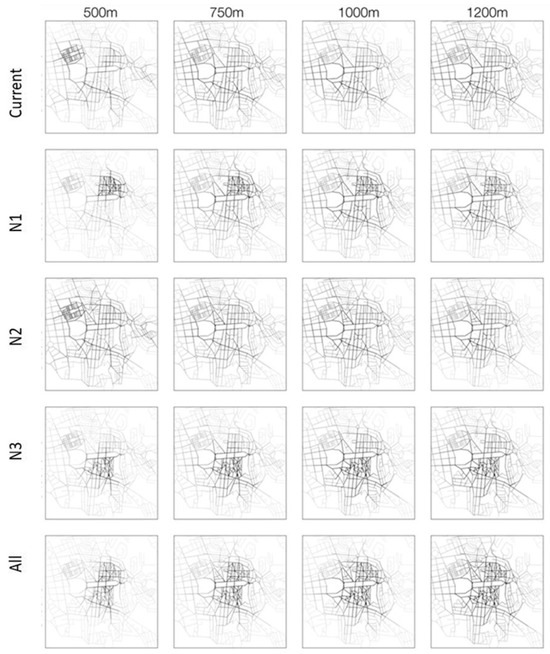
Figure 6.
T1024 Integration maps.
Figure 6 shows a comparison of the “Current” and “All” scenarios (including passages in the three neighborhoods simultaneously), and column analysis indicates that T1024 Integration increases notably in the areas defined by the three neighborhoods for all metric radii and decreases in the surrounding areas, which implies greater attractiveness of the neighborhoods with passages.
Opening passages in each neighborhood at the same time produces an increased effect on the T1024 Integration of the neighborhoods and the surrounding area as the metric radii increase, mostly in the orthogonal neighborhoods N1 and N3. Besides increasing the T1024 Integration within the neighborhoods, it also increases in all the surroundings as the metric radii increase.
Moreover, the mean and maximum of the T1024 Integration were quantitatively analyzed (Figure 7).
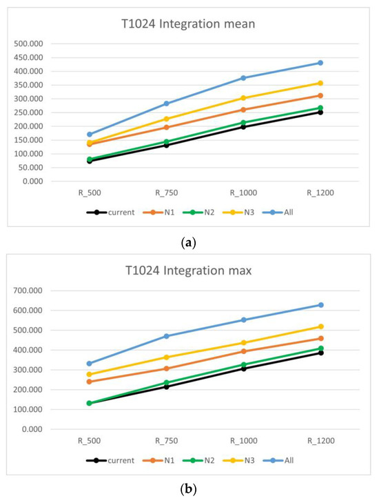
Figure 7.
T1024 Integration for the passage’s simulations: (a) T1024 Integration mean; (b) T1024 Integration maximum.
Globally, when passages are included in neighborhoods N1, N2, N3, and in All neighborhoods simultaneously, Figure 7 shows a T1024 Integration that is higher than in the Current scenario for all metric radii, both for background (mean) and foreground (maximum). In addition, the introduction of passages (blue line) in all three neighborhoods reveals the highest to-movement in the background (mean) and in the foreground (maximum). The passages opened in N2 (green line)—with a non-orthogonal urban fabric and large-sized blocks—did not significantly increase the T1024 Integration in the background (mean) or foreground (maximum). In N1 and N3 (orange and yellow lines), with orthogonal urban fabric, there is a relevant increase in the T1024 Integration in the background (mean) and foreground (maximum).
The coherence of the variation in the T1024 Integration between the means and maximums and mapping pictures is evident.
Figure 8 shows maps for the metric radii from 500 m to 1200 m of the T1024 Choice for the Current scenario: N1, N2, and N3 without passages (first line of Figure 8); N1, N2, and N3 with passages (second, third, and fourth lines, respectively, of Figure 8); and finally, with the passages in the three neighborhoods simultaneously, names All (last line of Figure 8). Globally, there is a small increase in the T1024 Choice when the metric radii increase as the passages are added in N1, N2, N3, and the three neighborhoods simultaneously (All scenario), all for metric radii from 500 m to 1200 m. As expected, this increase is more notable in the last case (Figure 8).
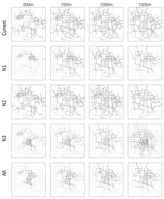
Figure 8.
T1024 Choice maps.
Comparing, in Figure 8, the Current with the All scenario (including the passages in the three neighborhoods simultaneously), the T1024 Choice increases notably for all metric radii in the areas defined by the three neighborhoods and decreases in the surrounding areas, which implies a higher probability of a street being used as part of a route in the neighborhoods with passages.
The orthogonality and block size of the neighborhoods do not seem to affect the T1024 Choice after opening passages in each neighborhood, with an evident increase in the T1024 Choice up to 1000 m in the orthogonal N1 and non-orthogonal N2 and up to 1200 m in the orthogonal N3. On the other hand, open passages in orthogonal N1 and N3, with medium- and small-sized blocks, respectively, decrease the T1024 Choice in the surrounding areas, whereas in non-orthogonal N2 with large-sized blocks, this does not happen.
In general, T1024 Choice and T1024 Integration show similar variations in their respective metric radii for through-movement both in the background (mean) and the foreground (maximum).
Figure 9 shows through-movement growth in the background (mean) and foreground (maximum) as the metric radii increase. It can also be observed that in the current situation (without passages), the through-movement in the background (mean) and foreground (maximum) always presents the lowest T1024 Choice (black line). These values are closely followed by N2 (green line), where a few passages were added. N1 (orange line) has higher through-movement in the background (mean) and foreground (maximum) than N2. N3 (yellow line), where a high number of passages were added, has higher through-movement in the background (mean) and foreground (maximum) than N1. The blue line that represents all the passages in the three neighborhoods reveals the highest through-movement (T1024 Choice) in the background (mean) and foreground (maximum).
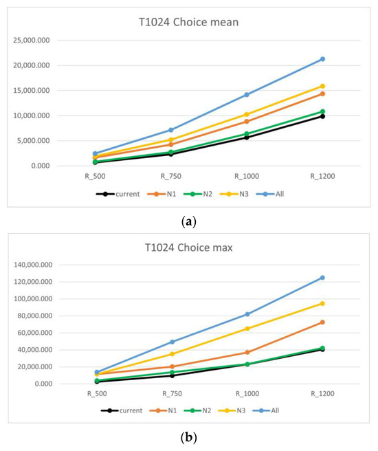
Figure 9.
Choice for the passage’s simulations: (a) T1024 Choice mean; (b) T1024 Choice maximum.
6. Discussion
Following the research carried out in [20] and the promising results that were obtained, the hypothesis of the urban fabric having an influence on walkability when passages are introduced in neighborhoods was tested. The results clearly show that the opening of passages in orthogonal neighborhoods contributes more to increasing walkability than in non-orthogonal neighborhoods. In orthogonal neighborhoods, the size of the blocks had no apparent effect on the walkability of these neighborhoods, although it was expected that larger blocks would benefit more, in terms of increased walkability, than smaller blocks.
Even though it is necessary to continue this study, its greatest contribution lies in the fact that the introduction of open passages through the interior of blocks increases pedestrian permeability, especially in orthogonal neighborhoods. In terms of walkability enhancement, the proposal to create passages that cross city blocks is a step in the right direction. These passages can connect streets, making it easier for pedestrians to move around, especially for vulnerable populations.
This research shows the importance of urban fabric for walkability and allows for its understanding. Regarding the block size, future research will be extended to other examples that may highlight significant differences in terms of walkability. Also, the idea of pedestrian-friendly design is complementary to creating passages since it can be an incentive for walkability; for example, wider sidewalks with smooth surfaces and proper lighting (including in the introduced open passages); the integration of green spaces along pedestrian routes; including benches, shelters, and public art to encourage walking in those passages and to ensure accessibility for people with disabilities.
Future project designs involving funding should conduct pilot projects in specific neighborhoods to test walkability interventions and measure their impact on pedestrian behavior, safety, and the overall quality of life using statistical methodologies. Another possible approach to evaluating the impact of creating passages through blocks would be to gather data on pedestrian movement patterns, traffic flow, and existing infrastructure.
Through continuous monitoring and a responsive feedback loop, the long-term impact of walkability interventions may be assessed while refining and adapting strategies over time to enhance health, the environment, and social well-being.
The simulated situations of opening passages that can be implemented in the future are inspired by cities where these already exist, such as Juíz de Fora, Brazil, and Prague, Czech Republic. The study of these cases, by fictitiously eliminating their passages, is another approach that could be tested to quantify their effective influence on urban mobility.
This entire discussion aims to provide a comprehensive overview and highlight effective strategies for making cities more pedestrian-friendly.
7. Conclusions
This study contributes to the affirmation that the addition of passages to the urban fabric increases and consequently promotes the local walkability, which is so necessary nowadays in the sense of a change in lifestyle. It shows that this increase is more notable in orthogonal neighborhoods (and does not apparently depend on the size of the blocks) than in a non-orthogonal urban fabric. In any case, there appears to be a dependent relationship between the urban fabric and the walkability increment. It was also noticeable that there was higher walkability in the orthogonal urban fabrics than in the non-orthogonal, with inconclusive results for the block size. A probable reason for this outcome may be explained by the perception that in an orthogonal urban fabric, any new path (open passage) is a potentially shorter one in terms of distance traveled. Further research should be carried out concerning this issue.
In addition, the to-movement and the through-movement in the background (mean) and foreground (maximum) always increase in all metric radii with the addition of passages. Therefore, it is shown that with open passages, neighborhood attractiveness and the probability of a street being used as part of a route increase in all metric radii, contributing to a more livable, dynamic, and humanistic city.
The opening of new passages, which are easy to implement in the building rehabilitation process, allows for obtaining an increase in permeability, which encourages walkability for old and consolidated cities’ inhabitants (especially the vulnerable population), ensuring safe, inclusive, and resilient mobility and creating attractiveness and well-being.
Simulations, as performed in this study, prove to be crucial for assessing the viability of open passages.
In conclusion, this research shows that passages are important for promoting the local walkability of old city neighborhoods where the street network cannot obviously achieve soft mobility. On a larger scale and in the long term, the achieved outcomes will certainly improve air quality, preventing climate change and moving toward sustainable urban planning. Particularly in Lisbon, this proposal meets the strategic pillar of “More Innovation”, as defined in [52] by the municipality.
This innovative approach affects the residents of the blocks in a more direct way since, in addition to the benefits listed above, it interferes with private collective spaces that become public, in line with the new Community Land Trust Brussels model (awarded by UN_Habitat 2021 with the World Habitat Gold Award), which is beginning to be supported by EU countries in the form of using collective ownership of land that removes it from the speculative market as a way of guaranteeing housing. Residents do not lose their private collective space, benefiting from sharing and community involvement in the building and space renewal. In this sense, it is essential to raise awareness of the importance of urban collaborative spaces that promote protection and social inclusion and ensure their renewal.
In short, opening passages and pre-existeng renewal bring countless benefits, both at a private, social, and community level, and contribute towards a paradigm change. Concerning cost estimations, it is premature given the exploratory nature of the approach.
Obviously, if there are no potential locations for passage openings, this approach is not viable. Also, this methodology only assesses walkability in terms of integration and choice measures.
Author Contributions
Conceptualization, J.T.R. and S.R.; methodology, J.T.R., A.R.V., S.R. and F.S.; software, F.S.; validation, J.T.R., S.R. and F.S.; formal analysis, J.T.R. and S.R.; investigation, A.R.V.; resources, F.S. and A.R.V.; data curation, F.S. and A.R.V.; writing—original draft preparation, J.T.R., A.R.V., S.R. and F.S.; writing—review and editing, S.R., F.S., A.R.V. and J.T.R.; visualization, A.R.V.; supervision, J.T.R.; project administration, J.T.R.; funding acquisition, J.T.R., A.R.V., S.R. and F.S. All authors have read and agreed to the published version of the manuscript.
Funding
This research was funded by FCT—Fundação para a Ciência e a Tecnologia, I.P., grant numbers UIDB/04008/2020, UIDP/04008/2020, and UIDB/04028/2020.
Data Availability Statement
Dataset available upon request from the authors.
Acknowledgments
The authors are grateful to student João Paulouro Neves for his support in preparing the images produced in DepthmapX.
Conflicts of Interest
The authors declare no conflicts of interest.
References
- UNEP (United Nations Environment Programme). Cities of the Future: The Ultimate Design Challenge. Available online: https://www.unep.org/news-and-stories/story/cities-future-ultimatedesign-challenge (accessed on 8 July 2019).
- Zaleckis, K.; Chmielewski, S.; Kamičaitytė, J.; Grazuleviciute-Vileniske, I.; Lipińska, H. Walkability Compass—A Space Syntax Solution for Comparative Studies. Sustainability 2022, 14, 2033. [Google Scholar] [CrossRef]
- van Nes, A.; Yamu, C. Introduction to Space Syntax in Urban Studies; Springer: Cham, Switzerland, 2021. [Google Scholar]
- Körmeçli, P. Analysis of Walkable Street Networks by Using the Space Syntax and GIS Techniques: A Case Study of Çankırı City. ISPRS Int. J. Geo-Inf. 2023, 12, 216. [Google Scholar] [CrossRef]
- INE (Instituto Nacional de Estatística). Projeções de População Residente 2018–2080. Destaque, Informação à Comunicação Social, Published on 31 March 2020. Available online: https://www.ine.pt/xportal/xmain?xpid=INE&xpgid=ine_destaques&DESTAQUESdest_boui=406534255&DESTAQUESmodo=2&xlang=pt (accessed on 3 August 2023).
- da Silva, A.N.R.; da Silva, D.C.; Providelo, J.K. Caminhabilidade em Um Cenário de Envelhecimento Populacional. In Cidades Pedrestres—A Caminhabilidade No Brasil e No Mundo (161–175); Andrade, V., Linke, C.C., Eds.; Babilonia Cultura Editorial: Rio de Janeiro, Brazil, 2017. [Google Scholar]
- Leeson, G.W. The growth, ageing and urbanisation of our world. J. Popul. Ageing 2018, 11, 107–115. [Google Scholar] [CrossRef]
- Braff, Z.; Melfi, T.; Cannon, E. Going in Style (Film); TM & Warner Bros. Entertainment Inc.: Burbank, CA, USA, 2017. [Google Scholar]
- WHO (World Health Organization). WHO’s Work on the UN Decade of Healthy Ageing (2021–2030). Available online: https://www.who.int/initiatives/decade-of-healthy-ageing (accessed on 3 August 2023).
- Rhoads, D.; Solé-Ribalta, A.; Borge-Holthoefer, J. The inclusive 15-minute city: Walkability analysis with sidewalk networks. Comput. Environ. Urban Syst. 2023, 100, 101936. [Google Scholar] [CrossRef]
- Hillier, B.; Penn, A.; Hanson, J.; Grajewski, T.; Xu, J. Natural Movement: Or, Configuration and Attraction in Urban Pedestrian Movement. Environ. Plan. B Plan. Des. 1993, 20, 29–66. [Google Scholar] [CrossRef]
- Gehl, J. Life between Buildings: Using Public Space; Island Press: Washington, DC, USA, 2011. [Google Scholar]
- Moreno, C. La ville du Quart d’heure: Pour un Nouveau Chronourbanisme. La Tribune. 2016. Available online: https://www.latribune.fr/regions/smart-cities/latribune-de-carlos-moreno/la-ville-du-quart-d-heure-pour-un-nouveauchrono-urbanisme-604358.html (accessed on 15 March 2020).
- Moreno, C. The 15 Min-City: For a New Chrono-Urbanism! Pr Carlos Moreno. 2019. Available online: http://www.moreno-web.net/the-15-minutes-city-for-a-new-chrono-urbanismpr-carlos-moreno/ (accessed on 15 March 2020).
- Allam, Z.; Moreno, C.; Chabaud, D.; Pratlong, F. Proximity-Based Planning and the “15-Minute City”: A Sustainable Model for the City of the Future. In The Palgrave Handbook of Global Sustainability; Springer International Publishing: Cham, Switzerland, 2020; pp. 1–20. [Google Scholar]
- Moreno, C.; Allam, Z.; Chabaud, D.; Gall, C.; Pratlong, F. Introducing the “15-minute city”: Sustainability, resilience and place identity in future post-pandemic cities. Smart Cities 2021, 4, 93–111. [Google Scholar] [CrossRef]
- Allam, Z.; Bibri, S.E.; Jones, D.S.; Chabaud, D.; Moreno, C. Unpacking the ‘15-Minute City’ via 6G, IoT, and Digital Twins: Towards a New Narrative for Increasing Urban Efficiency, Resilience, and Sustainability. Sensors 2022, 22, 1369. [Google Scholar] [CrossRef] [PubMed]
- Vieira, A.R. Edifícios Em Rede: Novas Centralidades. Ph.D. Thesis, University of Lisbon, Lisbon School of Architecture, Lisboa, Portugal, 2018. [Google Scholar]
- Vieira, A.R.; Ribeiro, J.T. Network Buildings: Definition and Assessment. IOP Conf. Series: Mater. Sci. Eng. 2019, 603, 25–32. [Google Scholar] [CrossRef]
- Ribeiro, J.T.; Vieira, A.R.; Rosado, S.; Serdoura, F. Urban planning revolution for increasing pedestrian mobility in Lisbon, Portugal. WIT Trans. Ecol. Environ. 2021, 253, 73–84. [Google Scholar] [CrossRef]
- Koohsari, M.J.; Oka, K.; Owen, N.; Sugiyama, T. Natural movement: A space syntax theory linking urban form and function with walking for transport. Health Place 2019, 58, 102072. [Google Scholar] [CrossRef]
- Hillier, B.; Hanson, J. The Social Logic of Space; Cambridge University Press: Cambridge, CA, USA, 1984. [Google Scholar]
- Ascher, F. Novos Princípios do Urbanismo: Seguido de Novos Compromissos Urbanos; Livros Horizonte: Lisbon, Portugal, 2010. [Google Scholar]
- Freitag, B. Teorias da Cidade; Papirus: Campinas, Brazil, 2006. [Google Scholar]
- Dudek-Klimiuk, J.; Warzecha, B. Intelligent urban planning and ecological urbanscape-solutions for sustainable urban development. Case Study of Wolfsburg. Sustainability 2021, 13, 4903. [Google Scholar] [CrossRef]
- UN-Habitat (United Nations Human Settlements Programme). Planning and Design for Sustainable Urban Mobility: Global Report on Human Settlements 2013; United Nations Human Settlements Programme: Nairobi, Kenya, 2014. [Google Scholar]
- Choi, E.; Koch, D. Movement and the connectivity of streets: A closer look at route distribution and pedestrian density. In Proceedings of the 10th International Space Syntax Symposium (65.1–65.11), London, UK, 13–17 July 2015. [Google Scholar]
- Garau, C.; Annunziata, A. Public open spaces: Connecting people, squares and streets by measuring usability through the Villanova district in Cagliari, Italy. Transp. Res. Procedia 2022, 60, 314–321. [Google Scholar] [CrossRef]
- Choay, F. O Urbanismo; Editora Perspectiva: São Paulo, Brazil, 2000. [Google Scholar]
- Speck, J. Walkable City; North Point Press: New York, NY, USA, 2013. [Google Scholar]
- Alexander, C. A city is not a tree. Architectural Forum 1965, 122, 58–62. [Google Scholar]
- Aly, J.A.F. Arquiteturas da Cidade: Conexões e Lugar. Ph.D. Thesis, USP-Faculdade de Arquitetura e Urbanismo, São Paulo, Brazil, 2010. [Google Scholar]
- UN-Habitat (United Nations Human Settlements Programme); ITDP (Institute for Transportation & Development Policy). Streets for Walking & Cycling Designing for Safety, Accessibility, and Comfort in African Cities; United Nations Human Settlements Programme; Institute for Transportation & Development Policy: New York, NY, USA, 2018. [Google Scholar]
- Salvi, A.E.; Carriço, J.M.; de Almeida, R. Transition between internal and external areas of buildings with free ground in São Paulo and New York. Rev. Posfauusp 2021, 28, e168263. [Google Scholar]
- van Nes, A. Spatial configurations and walkability potentials. measuring urban compactness with space syntax. Sustainability 2021, 13, 5785. [Google Scholar] [CrossRef]
- Stockton, J.C.; Duke-Williams, O.; Stamatakis, E.; Mindell, J.S.; Brunner, E.J.; Shelton, N.J. Development of a novel walkability índex for London, United Kingdom: Cross sectional application to the Whitehall II Study. BMC Public Health 2016, 16, 416. [Google Scholar] [CrossRef] [PubMed]
- Liang, Y.; D’Uva, D.; Scandiffio, A.; Rolando, A. The more walkable, the more livable? Can urban attractiveness improve urban vitality? In Proceedings of the XXV International Conference Living and Walking in Cities—New Scenarios for Safe Mobility in Urban Areas (LWC2021), Brescia, Italy, 9–10 September 2021. [Google Scholar]
- Baquero-Larriva, M.T.; Higueras-García, E. Factores ambientales que influyen en el uso del espacio público para las personas mayores en Madrid. Rev. Urbano 2019, 40, 108–126. [Google Scholar] [CrossRef]
- Distefano, N.; Leonardi, S.; Liotta, N.G. Walking for sustainable cities: Factors affecting users’ willingness to walk. Sustainability 2023, 15, 5684. [Google Scholar] [CrossRef]
- Huang, J.; Lu, X.X.; Sellers, J.M. A global comparative analysis of urban form: Applying spatial metrics and remote sensing. Landsc. Urban Plan. 2007, 82, 184–197. [Google Scholar] [CrossRef]
- Ribeiro, A.I.; Hoffimann, E. Development of a neighbourhood walkability index for porto metropolitan area. How strongly is walkability associated with walking for transport? Int. J. Environ. Res. Public Health 2018, 15, 2767. [Google Scholar] [CrossRef]
- Fan, P.Y.; Chun, K.P.; Mijic, A.; Tan, M.L.; Liu, M.S.; Yetemen, O. A framework to evaluate the accessibility, visibility, and intelligibility of green-blue spaces (GBSs) related to pedestrian movement. Urban For. Urban Green. 2022, 69, 127494. [Google Scholar] [CrossRef]
- Eboli, L.; Forciniti, C.; Mazzulla, G.; Bellizzi, M.G. Establishing performance criteria for evaluating pedestrian environments. Sustainability 2023, 15, 3523. [Google Scholar] [CrossRef]
- Koohsari, M.J.; Oka, K.; Nakaya, T.; McCormack, G.R. Urban form metrics for promoting walking: Street layouts and destinations. J. Urban Health 2023, 100, 1024–1031. [Google Scholar] [CrossRef] [PubMed]
- Dragović, D.; Krklješ, M.; Slavković, B.; Aleksić, J.; Radaković, A.; Zećirović, L.; Alcan, M.; Hasanbegović, E. A literature review of parameter-based models for walkability evaluation. Appl. Sci. 2023, 13, 4408. [Google Scholar] [CrossRef]
- Al_Sayed, K.; Turner, A.; Hillier, B.; Iida, S.; Penn, A. Space Syntax Methodology, 4th ed.; Bartlett School of Architecture, UCL: London, UK, 2014. [Google Scholar]
- Yamu, C.; van Nes, A.; Garau, C. Bill Hillier’s Legacy: Space syntax—A synopsis of basic concepts, measures, and empirical application. Sustainability 2021, 13, 3394. [Google Scholar] [CrossRef]
- Hillier, B. Space as paradigm for understanding strongly relational systems. In Proceedings of the 2nd International Space Syntax Symposium (56.1–56.16), Brasilia, Brazil, 29 March–2 April 1999. [Google Scholar]
- Hillier, B.; Yang, T.; Turner, A. Normalising least angle choice in Depthmap and how it opens new perspectives on the global and local analysis of city space. Space Syntax. 2012, 3, 155–193. [Google Scholar]
- Penn, A.; Hillier, B.; Banister, D.; Xu, J. Configurational modelling of urban movement networks. Environ. Plan. B Plan. Des. 1998, 25, 59–84. [Google Scholar] [CrossRef]
- Carmona, M. Explorations in Urban Design: An Urban Design Research Primer; Ashgate Publishing: Farnham, UK, 2014. [Google Scholar]
- CML (Câmara Municipal de Lisboa). Move Lisboa—Strategic Vision for Mobility 2030; CML: Lisboa, Portugal, 2020. [Google Scholar]
- Orsini, H.F. Belgrade’s urban transformation during the 19th century: A space syntax approach. Geogr. Pannonica 2018, 22, 219–229. [Google Scholar] [CrossRef]
Disclaimer/Publisher’s Note: The statements, opinions and data contained in all publications are solely those of the individual author(s) and contributor(s) and not of MDPI and/or the editor(s). MDPI and/or the editor(s) disclaim responsibility for any injury to people or property resulting from any ideas, methods, instructions or products referred to in the content. |
© 2024 by the authors. Licensee MDPI, Basel, Switzerland. This article is an open access article distributed under the terms and conditions of the Creative Commons Attribution (CC BY) license (https://creativecommons.org/licenses/by/4.0/).