Article

Impact of Neighborhood Urban Morphologies on Walkability Using Spatial Multi-Criteria Analysis

by
Sara Ibrahim
1,
Ahmed Younes
2 and
Shahira Assem Abdel-Razek
1,*
1
Department of Architectural Engineering, Faculty of Engineering, Delta University for Science and Technology, Gamasa 11152, Egypt
2
Department of Geography & GIS, Faculty of Arts, Fayoum University, Al Kiman St., Fayoum 63514, Egypt
*
Author to whom correspondence should be addressed.
Urban Sci. 2024, 8(2), 70; https://doi.org/10.3390/urbansci8020070
Submission received: 5 May 2024 / Revised: 1 June 2024 / Accepted: 13 June 2024 / Published: 17 June 2024

Abstract

:
With the increase in car domination, air pollution, traffic congestion, and urban sprawl, sustainable, livable, creative, and walkable cities are critical, now more than ever, for improving quality of life. The effect of neighborhood urban morphologies on walkability has received much attention in recent years. In this vein, the main research question is: how do different neighborhood urban morphologies impact the level of walkability in urban environments, and what are the essential elements impacting the walkability index? Thus, this research aims to determine the impact of urban morphology on walkability in the city of Alexandria, Egypt, as a case study by utilizing multi-spatial analysis. In particular, the study focused on assessing the walkability of four different study areas that vary according to their urban morphology: Kafr–Abdo, Smouha, Latin Quarter, and Roushdy areas. The analysis utilized GIS to calculate a number of indicators to reach the final walkability index for each study area. Results helped to identify the neighborhoods characterized by the lowest level of pedestrian walkability in relation to the area’s urban morphology in an attempt to help decision-makers suggest the appropriate interventions for those areas. The aggregated index results showed that the highest walkability index was that of the gridiron morphology, followed by the linear morphology, with the radial and organic morphologies coming in behind them, respectively. The composite walkability index values were 0.364, 0.247, 0.232 and 0.225, respectively. The reason for this is mainly the presence of the commercial density, intersection density, street density, services density, BCR, and residential density.

1. Introduction

One of the major difficulties confronting cities throughout the world is encouraging the shift toward sustainable urban mobility plans that are centered around public transportation, shared micro-mobility, and active modes of transportation (i.e., walking and cycling) [1,2,3]. As a result of the fast pace of life, most cities are facing relevant issues such as traffic congestion, road safety, energy dependency, and air pollution [4] due to urbanization and the increasing demand for vehicle usage. Ultimately, countries worldwide are actively trying to implement sustainability measures that focus on promoting active mobility instead [5]. However, individuals’ travel patterns, “commute patterns”, are a physical outcome of several factors: interaction between the built environment, cultural backgrounds, society’s physical needs, and the potential of mode availability [6,7]. Globally, walking and cycling have been recognized for their successful contribution to humanizing cities [8]. In this setting, urban mobility planners’ practices are shifting to an emphasis on walkability, or how friendly the urban environment is for walking, residing, visiting, or spending time in public spaces.
The impact of walkability on the quality of life of citizens has long been established in academia, whether through enhancing residents’ physical activity, improving air quality through the decrease of emissions, enhancing wellbeing, promoting social inclusion, and providing pleasurable leisure spaces for all that focus on the human scale and allow people to enjoy walking and gathering in comfort [6,9]. Walkability also contributes to the making of creative cities. Studies have shown that walking and cycling can serve to stimulate the brain to eliminate negative thoughts through the increase of oxygen flow, thus promoting relaxation, enhancing productivity, and deepening focus. It also facilitates the “living in the moment” notion, which diminishes negativity. All these combined aid in enhancing both creativity and productivity. Several empirical studies have found that active commuters are found to be physically and mentally in a better state, even if this is their only form of exercise [10,11].
A study carried out on students found a positive correlation between students’ cognitive retention and their physical activities, which led them to better academic success [12], while another study shows that students who walk to school are usually more alert and ready to learn than those using other forms of mobility [13]. Another study showed that active commuters’ perception and responsiveness have a strong association with safety, physical effort, health, comfort, freedom, flexibility, accessibility, and level of suitability [14].
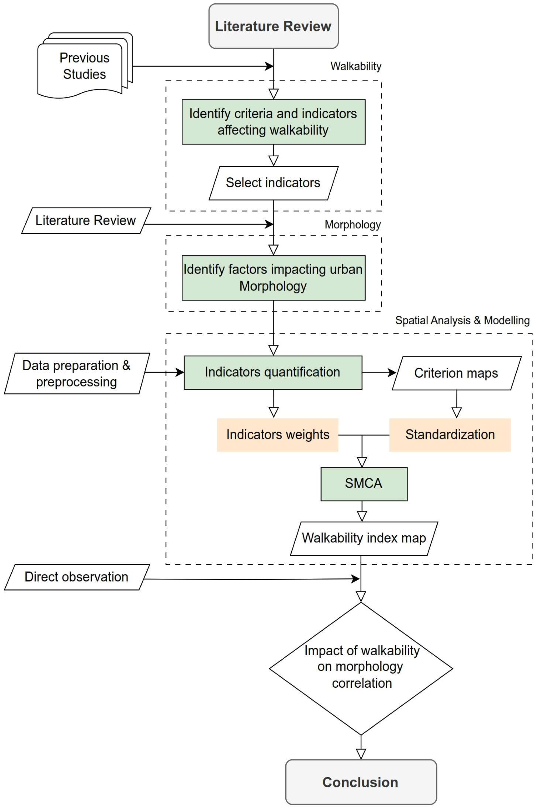
However, many factors affect willingness and perception of walkability, including but not limited to the factors pertaining to urban form and morphology. These factors include street density, intersection density, and residential density, among others. Other factors include adequate areas to walk, width and quality of sidewalks, presence of services, and social interactions. Taking into consideration the above, the current research focuses on assessing different urban morphology indicators to evaluate whether they, in turn, have an impact on walkability or not. The novelty of this research lies in the fact that few researchers have explored the link between both walkability and urban morphology and thus will try to diminish the gap present in the current literature, as well as aid stakeholders and decision-makers in making informed academic-based decisions regarding enhancing walkability in neighborhoods and ultimately cities to improve quality of life. The first part of the research introduces a theoretical review of the basic concepts of walkability, urban morphology, its types, and the factors affecting it. The second part is the practical application of the GIS-based methodology to assess the level of walkability in four different neighborhoods in the city of Alexandria, Egypt, as a case study to investigate if the neighborhoods’ urban morphologies impact walkability or not. Figure 1 illustrates the framework of the research structure as follows:

2. Literature Review

2.1. Walkability as a Concept

Walkability, although not a new notion, has received vast interest in the worlds of both sustainability and academia. Although not the easiest of solutions in a world that is vastly dependent on vehicle usage and complex transportation systems, it is an equation that may provide adequate answers if derivable inputs are designed according to human preference instead [15]. Previous research regarding walkability can be categorized into four main domains: physical health and wellbeing of walking, factors affecting walking, and the economic value and sustainability of walking. However, when it comes to the second point, the factors affecting walkability are not fully comprehensive, as they are an intricate blend of many inputs that may differ from one location to the other and may often be overlooked. The measures of urban design and planning that affect walkability are numerous, including but not limited to disciplines like urban form and urban morphology.
While walking is an inherent skill that comes naturally to most of the world’s population, walkability is a measure of how easy it is for people to walk around a certain spatial area, with the aim of reaching services, providing exercise, committing socially, or for plain leisure. Research shows that a shift has occurred in the planning scheme of cities in recent years that is more focused on providing walkable spaces in opposition to the trends before that focused on bereft road networks for vehicles and other transportation modes [16,17]. This comes as no surprise as the world faces more and more environmental impacts and challenges arising from the continuous adamant belief that faster is better in this high-paced world. The edge of the precipice came into focus with single-person vehicle usage, which meant a higher influx of vehicles on the road, higher emissions, increased usage of fuel, the higher maintenance cost of roads, and round-the-clock congestion, ultimately leading authorities to think in a streamlined process and offer road expansion or increase the road network to accommodate the influx, leading to a constant loop. After this, countries decided to implement incentives to use shared modes of transportation, such as carpooling, increased public transportation networks, decreased cost of using public and shared mobility options, and increased price of fuel.
According to the literature, sustainable, livable, and walkable cities have become essential for enhancing the quality of life, especially given the constant increase in vehicle dominance, air pollution, dense traffic, and urban sprawl in cities. Walking is healthy, free of pollutants, and a less noisy mode of transportation that also promotes and enhances social interaction and cohesion. Numerous criteria define and impact walkability, and many studies have focused on them. For instance, Visvizi et al. delved into walkability as a utility that may provide economic value [18], while others discussed the indicators that affect user perception [19,20,21]. Another study emphasized the factors that affect walkability, including building placement, street design, and land use [22], not to mention the one that focused on the spatial configurations that influence walkability [23]. These previous parameters, while heavily interlinked with walkability, are also within the parameters of urban morphology. It is with this backdrop that researchers aimed to understand the link between these two urban fields of study. Coupled with all the above, many have focused on the crucial duality that arises from linking sustainability measures to walkability.

2.2. Urban Morphology

Urban morphology, as an academic discipline, encompasses the examination of the physical structure and form of the city, including its edifices, thoroughfares, and open areas. More precisely, it concentrates on the analysis of the constitution and configuration of urban fabric components over time, establishing their compositions and arrangements [24]. Urban morphology also entails the investigation of urban forms [25] and the entities and procedures accountable for their modification over time. It is a multidisciplinary domain that can be examined at various spatial scales and within the context of different disciplines, namely urban geography, history, architecture, and spatial economics. In its practical applications, it serves as a crucial element of urban design while also being of interest to development, urban planning, and urbanization [26,27]. Urban morphology also has a dire effect on the quality of life of its residing citizens, whether through its direct impact on physical health and activity, its influence on mental health and wellbeing, its contribution to economic opportunities, or its aid in social cohesion and community mobilization. The impacts of urban morphology are numerous and have been rigorously researched; however, the linkage between urban morphology and walkability, although analyzed through some studies, still needs further research and analysis. Urban morphology includes several types, as mentioned in Table 1.

2.3. Factors Impacting Urban Morphology

Researchers have identified numerous factors that affect urban morphology, including land use, connectivity, population density, the occurrence of urban facilities [30], development density, land use, vegetation index, building materials, street orientation [31], sky view factor, floor area ratio, site coverage ratio, and building stories [32], among others. All these factors influence the formation of urban morphology besides the main players: topography, history, political influence, social and community influences, and economic constraints. Connectivity and street design, as well as the presence of facilities and their incidence, are crucial in shaping different urban morphologies.
It is with this background that the researchers questioned the interrelations between the impact of different urban morphologies on walkability, hypothesizing that different types of morphologies will affect whether or not an area is deemed walkable.

2.4. Intertwining Factors between Walkability and Urban Morphology

The interlink between walkability and urban morphology stems from the indices that affect both, which are often somewhat similar. In its truest sense, the factors of urban morphology are the shaping factors of the physical form of the city influenced by socio-economic, cultural [33], and natural factors [34]. It also includes factors pertaining to the morphology of the buildings in the area, infrastructure (including blue, green, and gray) [35,36], building form (heights, volumes, and shapes) [37], development density [38], land use, street orientation and connectivity, spatial distance, and metrics, and above all the perception of citizens to all the above. Additional measures such as street configurations [39] and green spaces [40] also influence urban sustainability parameters like urban heat islands and air quality [41], which in turn affect user perception of walking [21].
Mohsen and Ahmadieh stated that the walkability of a neighborhood is influenced by the physical attributes of the urban fabric and land use; however, their research failed to provide specific details on how urban morphology impacts walkability [42]. It was found that urban morphology, specifically street network connectivity measures such as intersection density, block length, and the link-to-nodes ratio, have an impact on walkability [43].
Another important measure that is often utilized is the land-use diversity indicator, which is intended to measure the number of diverse land uses in a given area and the degree to which they are represented in that area, in turn, sheds focus on the functionality of walking to reach specific services as well as the practicality to reach those services [43,44]. It also examines the level of spatial heterogeneity in terms of the proportion of different land-use types within an easily walkable area, or lack of it, to determine whether the different land uses in an area will support the various requirements of the inhabitants, ultimately impacting their trip generation [45,46]. Moreover, an increment of this indicator means that there will be more walking and cycling in the community [47]. This is not to be confused with the land-use mixedness indicator, which measures how other land uses are mixed with residential land use. This indicator was also used to express the walkability and cyclability of an area. In a recent study, it was found that by adequately mixing residential land use with other land uses, people can be encouraged to cycle or walk to do their daily activities [48].
Among the vast body of research done on walkability, the notion of the area being compact and diverse is ultimately linked to being walkable, as is evident in trends like the x-minute city and CDW (compact, diverse, and walkable) neighborhoods [49,50,51]. Among the criteria set out in these studies, emphasis on street design, sidewalk accessibility, pattern, and design, as well as connectivity and separation from vehicle traffic, is ultimate. Street design should prioritize pedestrians over cars and have an overall impact on the security, health, and social relations of the urban environment. Adequate shading from the elements should be prioritized, as well as scenic views and diminished acoustic and visual pollution. From the above, the indicators impacting walkability were deduced (Table 2).
The above factors each impact walkability, either through the ease of traveling to and from services, the practicality of using walking as a mode of transport, or the quality of the walking experience itself. These impacts can affect the perception of walkability, either divided or combined. Table 2 sums up the challenges that may impact user perception of walkability. The criteria were then aligned with the common principles of the 5 Ds affecting walkability (density, diversity, design, destination accessibility, and distance to transit), as identified by Ewing and Cervero, among others [54], and the following was achieved (Table 3). As the current research focuses mainly on the spatial aspects, neither environmental nor demographic factors were taken into consideration during the current analysis.

3. Materials and Methods

3.1. Methodology and Data Sources

The current study relies on a four-stage GIS-based methodology as a way to assess the walkability of four different study areas in Alexandria, Egypt, which vary according to their urban morphology: the Latin Quarter, Smouha, Kafr–Abdo, and Roushdy neighborhoods. The methodology utilized GIS for the four study areas to calculate each indicator and spatially obtain the comprehensive walkability index values, and this is conducted through four stages:
  • First, the research used qualitative analysis to identify the criteria and indicators that are important to assess walkability and would also be attained for the selected case study. Considering the data availability, the authors must drop some indicators from the analysis. Table 3 summarizes the criteria and indicators that were finally adopted for this study.
  • Second, using the study area boundaries for the selected neighborhoods, land-use data were reclassified into 23 classes. Moreover, to extract the service layer, 12 types of services are also reclassified to be used for calculations of the densities and distance concept to compare the urban morphology for the four selected areas.
  • Third, as given in Table 3, 12 indicators were calculated spatially in ArcGIS to measure the walkability index across the four study areas using spatial multi-criteria analysis (SMCA). The following sub-sections show details of the calculations and formulas for each indicator.
  • At the final stage, the results were aggregated and mapped, revealing the final walkability index values for the four study areas. After the initial mapping and spatial analysis were completed, direct observations were carried out by the authors to better understand the final outcome.
After acquiring the data, spatial analysis was conducted utilizing ArcMap 10.8 software. The primary data were obtained from the field visits through direct observations. Moreover, the researchers utilized secondary data, encompassing both GIS spatial data and attribute data. This spatial data included administrative boundaries, land use, and transportation-related data such as road networks, bus stations, and public transport stations, as well as services-related data, such as educational, religious, social, healthcare facilities, etc. The secondary data were sourced from authorized entities in Egypt, including the Governorate of Alexandria (GOA), the Alexandria Passenger Transport Authority (APTA), and the General Organization for Physical Planning (GOPP). These data, in the form of shapefiles, were then linked to a geodatabase for subsequent use in calculation procedures. Missing data were obtained from publicly accessible sources, and a subset of the population density raster data was downloaded and extracted from [55]. Additionally, the authors digitized street-side trees in the four case studies using Google Earth Pro version 7.3 images. Figure 2 illustrates the flowchart of the technical procedures implemented at various stages of the methodology.

3.2. Data Preparation and Pre-Processing Procedures

3.2.1. Reclassification of Services and Land-Use Classes

The data preparation commenced with reclassifying the acquired land-use GIS data, the commercial land use that includes businesses, shops, companies, and stores, and extracted some other classes such as green spaces and military land use. Therefore, the final data were classified into 12 services and 23 types of land-use classes found in the selected study areas as follows:
  • Infrastructure and Utilities
  • Commercial (i.e., banks, shops, stores, supermarkets, restaurants, shopping centers)
  • Healthcare (i.e., hospitals, clinics, healthcare centers, etc.)
  • Educational (i.e., schools, universities, faculties, educational centers, kinder gardens, etc.)
  • Religious (i.e., Churches, Mosques, Islamic complexes, Christian centers, etc.)
  • Cultural (i.e., cultural theatres, museums, cultural centers, libraries, etc.)
  • Governmental and administrative (i.e., postal office, Police stations, etc.)
  • Sports services (i.e., stadiums, sports clubs, gyms, etc.)
  • Recreational (i.e., clubs, cinemas, recreational centers, etc.)
  • Industrial (i.e., factories, clothes factories, workshops, etc.)
  • Social (i.e., orphanage centers, social services, social halls, etc.)
  • Touristic (i.e., hotels, motels, touristic compounds, etc.)

3.2.2. The Spatial Unit for Calculations

According to numerous studies, walkability is categorized into four levels: state/province, city, neighborhood, and streets [56]. The “spatial unit” for calculating the walkability index and its associated indicators is a technical challenge in geographic information systems (GIS) methodology. There is no consensus on which spatial units are most suitable for analysis [57,58], meaning that the spatial unit may skew the outcome of any analysis, including the walkability index [59].
Mitchell’s [60] grid tessellation of space is acknowledged as a well-established approach that serves multiple purposes. First, it aids in modeling spatial phenomena by employing an optimal number of spatial features through grid cells. Second, it effectively captures and accurately represents the spatial variation of underlying indicators. Last, it ensures the maintenance of an efficient and manageable spatial database along with computation procedures. In this study, various grid tessellations, including 100 × 100, 200 × 200, 300 × 300, and 500 × 500 m, are proposed using the “fishnet” tool from the ArcGIS 10.8 toolbox.
In 51 studies, it was found that the spatial unit used to calculate the walkability index and related indicators varied from 100 m and up to 10 miles. Surprisingly, only 4 studies used units less than 300 m, while the majority used units greater than 300 m, with most using 400 m or more [57]. The spatial units were used as buffer zones. In studies that used buffer zones in their analyses to assess walking score or walkability, the size of the buffer zones varied in spatial dimensions. It was discovered that 97.2% of the buffer zone dimensions were larger than 300 m [61].
Due to the spatial conditions of the study area and based on the justifications from the previous research, a cell size of 300 × 300 m was specifically chosen as the spatial unit for measuring the walkability index, taking into account the context of Alexandria city and the cell size of the grid.

3.3. SMCA and Geoprocessing Model

Following the preparation of GIS data, the initial phase of the analysis involved computing the adopted indicators spatially. Once the values for each indicator were computed, the next step in the geoprocessing model involved standardizing these indicator values so that they could be compared and combined. The final step entailed aggregating the spatially standardized indicators to obtain the composite walkability index value for each grid cell.

3.3.1. Computing the Individual Indicators

As for computing each indicator, first, the density indicator was measured in the form of the variable of interest per unit area. In this study, the total number of variables within walking distance in the form of absolute number per cell is taken to measure densities. This method is adopted by [45,48,52,62] and more. The authors calculated the density of some indicators as raster data, such as services, streets, junctions, transit stations, green spaces, residential use, commercial use, and trees, using the “Point Density” tool from the ArcGIS 10.8 toolbox. The main land-use data source used to calculate these indicators is the building footprint data that contains building footprints and the attributes of each building.
Population density (Inhabitants/Sq km)
Residential density (Number of residential buildings/Sq km)
Commercial density (Number of commercial enterprises/Sq km)
FAR = Total   floor   area   1 st   floor   area + 2 nd + 3 rd + .. Site   area
BCR = Building   area   footprint Site   area
Second, the authors tried to assess the differences between the study areas regarding distance to services and transit stations, so the distances were calculated using the “Path Distance” tool from the ArcGIS 10.8 toolbox. Third, regarding the FAR and BCR calculations, the authors used the “Dissolve” tool to calculate the areas of buildings at every cell, and then the “field calculator” was utilized to calculate the BCR indicator. For calculating the FAR, the “Intersect” tool was used for the buildings layer, then the “Summarize” tool was used to calculate the total (Floors x Building area), and then the “Join” tool was used to join the extracting table from the last step with the fishnet layer (grid cells) and to complete the calculation by field calculator.
Finally, regarding the land-use diversity (level of mixed use) and mixedness calculations, a spatial model is created. In the model, every land-use class is calculated individually, and the output is extracted as a raster layer. Then, the “Map Algebra” and “Raster Calculator” tools are used to calculate the level of mixed use for every land-use class. There are different approaches to measuring land-use diversity, and the entropy method, as shown in Equation (6), is utilized in this study. Since the established methods that compute land-use diversity have been working with raster data, a geoprocessing model is utilized again to compute diversity based on the vector data. This method is utilized by [45,52] based on the work of [63].
LU d   ( i ) =   i = 1   n     Qlui   × ln Qlui ln n   ,   where   Q Lui = S l u i   S i
where
  • LUd (i) is the land-use diversity in the area of analysis i,
  • Lui = the land use class (1, 2, 3, 4, …, n) in the area of analysis i,
  • QLui = the ratio of the area within the area of analysis i,
  • n = the total number of the different land uses in the area of analysis i,
  • SLui = total area of land use j within the area of analysis i,
  • Si = total area of the area of analysis i.
The resulting index ranges between 0 and 1, where a value of 1 (heterogeneity) implies the most balanced mix of land uses (highest diversity level), and a value of 0 (homogeneity) indicates the presence of no diversity at all or just one type of land use.
The mixedness indicator is computed using Equation (7), which was used by [64] and later utilized by many researchers like [48,52,62], employing vector land-use data.
Mixedness   index   ( MI ) =     i   S c     i   S c + S r
where
  • MI is the mixedness index for the area of analysis i,
  • Sc shows the sum of the total area of other land uses within the area of analysis i
  • Sr is the sum of the total land area under residential land use within the area of analysis i.
The indicator’s value ranges from 0 to 1, where a value of 0 indicates the absence of residential land use, and a value of 1 shows the highest mixed-use index. A balanced mixedness of land use is best at 0.5, which implies an equal share of residential land use with other land uses [65,66].

3.3.2. Standardization of Indicators

After each indicator’s value was determined, SMCA then standardized the indicator values so that they could be compared and combined. This is an important and necessary step to ensure that the indicators, although measured in different measurement units, conform. There are several methods to achieve this (i.e., maximum, interval, goal, concave, convex, curve, or U-shape), which convert initial values of indicators into standardized values from 0 to 1, where 1 represents the highest value. In the current study, the researchers employ the maximum method. Each pixel in the map is divided by the maximum value at the raster layer, and the goal of the indicator is to reach a value of 1 (ranging from zero to the maximum value). The “Rescale by Function” tool from the ArcGIS 10.8 toolbox is utilized, and the output is a new raster layer with pixel value extended from 0 to 1, where the value 0 refers to a low index value, and 1 refers to a high index value.

3.3.3. Assign Weights to Indicators

In this stage, criterion weights need to be defined after standardization to reflect their relative importance and the strength of their association with the final index. Indicators can be weighted by one or multiple groups of stakeholders, such as policymakers, planners, researchers, and others, based on their perceptions. Given the varying contexts of previous studies found in the literature, the authors adopted a base scenario of equal weights. This means that all indicators are assigned the same rank and, hence, the same weight, avoiding bias in the results. Using the equal weighting scenario allows the strength of the calculated indicators to be measured clearly while limiting confounding effects.

3.3.4. Computing the Composite Walkability Index

The above-computed output was then aggregated for the spatially standardized indicators to obtain the composite walkability index value for every grid cell. The composite index is calculated by adding up the results of multiplying the standardized indicator value by the weight-associated variable (see Equation (8)). This operation is called the weighted linear combination method, where higher values represent the highest walkability index. A “Raster Calculator” tool is utilized first to calculate the average value of all standardized layers. Concerning the weights of the adopted indicators, the researchers had to assign equal weights for the current study as it matched the scope of the research. The authors will work on conducting a questionnaire for these study areas for further assessment. A visual inspection of the resulting walkability index map can show where the areas that have a high walkability index correspond to a certain urban morphology.
Si = i = 1 n W i × R i
where the composite walkability index Si for each pixel i,
  • Wi is the multiplication result of the weights of all indicators or criteria,
  • Ri the standardized values of each pixel in the map of the indicator or criterion,
  • n is the total number of the indicator or criterion.

4. The Study Area

Alexandria, the second biggest city in Egypt, stretches about 70 km along the Mediterranean Sea and consists of nine districts, including the Wasat and Sharq districts, the districts where the selected neighborhoods are located. Alexandria was chosen because it is a cosmopolitan city full of diverse cultures and ethnic profiles. It is an added value in research due to its massive and diverse backgrounds, as well as its being a multi-layered city that has absorbed civilizations across the ages and, in turn, may act as a model for other areas, whether old or new.
The selection of the areas chosen was according to the following criteria: (1) differing in terms of urban morphology; (2) nearly equal in area; and (3) close in terms of socio-economic conditions.
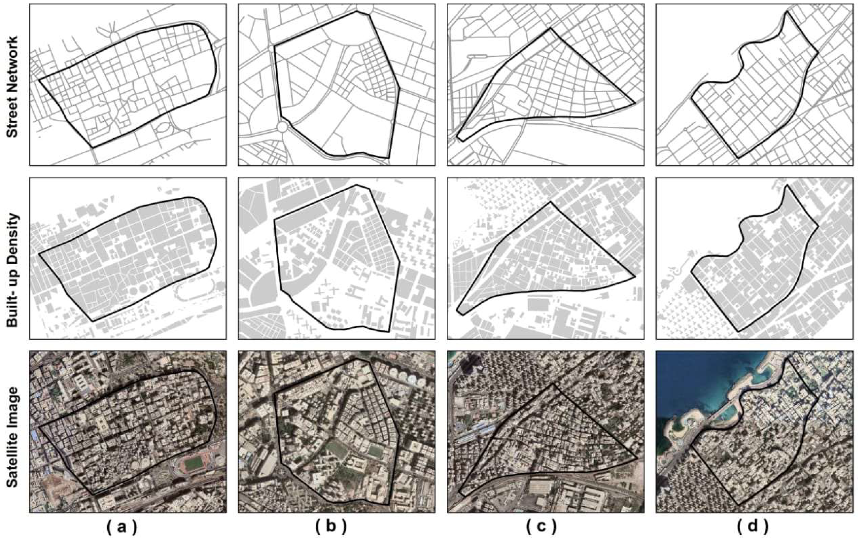
Comparing neighborhoods using these criteria allows the strength of built environment variables (urban form factors) to be measured clearly while limiting the confounding effects of the other variables. Since the spatial analysis on built environments would be time-consuming to compile for the entire district’s neighborhoods, the researchers limited the study areas to four neighborhoods with 4 different morphologies, as shown in Table 4 and Figure 3. The four neighborhoods are situated within the main city of Alexandria, which is characterized by its densely populated areas, and exhibit diverse spatial patterns as a result of the irregular planning in the area. The following table (Table 4) shows the details regarding each specific area, including its morphology and characteristics.

5. Results

First, the results of the spatial calculation of each indicator were mapped and presented in Figure 4, Figure 5, Figure 6, Figure 7, Figure 8, Figure 9 and Figure 10. Comparative exploration of the computed indicators (quantified maps) and the urban morphology of the study areas demonstrate how they affect walkability. As shown in Figure 4, the FAR calculated for each pixel area of the chosen areas concludes that Roushdy (Case D) has the highest FAR, followed by Kafr–Abdo (Case C), Latin (Case A) Neighborhood, with Smouha (Case B) having the least FAR calculations. This coincides with the findings witnessed through the observation sheets that showed that the FAR of these areas, as recently the area of Kafr–Abdo, which was once a higher socio-economic area characterized by its villas and one-story homes, has witnessed a boom in construction, while Smouha, a relatively new neighborhood, has not yet changed.
The BCR indicator map (see Figure 5) shows that the building area almost covers the total land area (grid cell) in the Latin, Kafr–Abdo, and Roushdy neighborhoods. The highest value is 85.7 and is found in the Latin and Roushdy neighborhoods, followed by medium values in some parts of the Kafr–Abdo neighborhood, then the lowest values are found in the Smouha neighborhood, which corresponds to the campuses of the Faculty of Nursing, the Faculty of Economic Studies and Political Science at Alexandria University, university student dormitories, or Zahran experimental school.
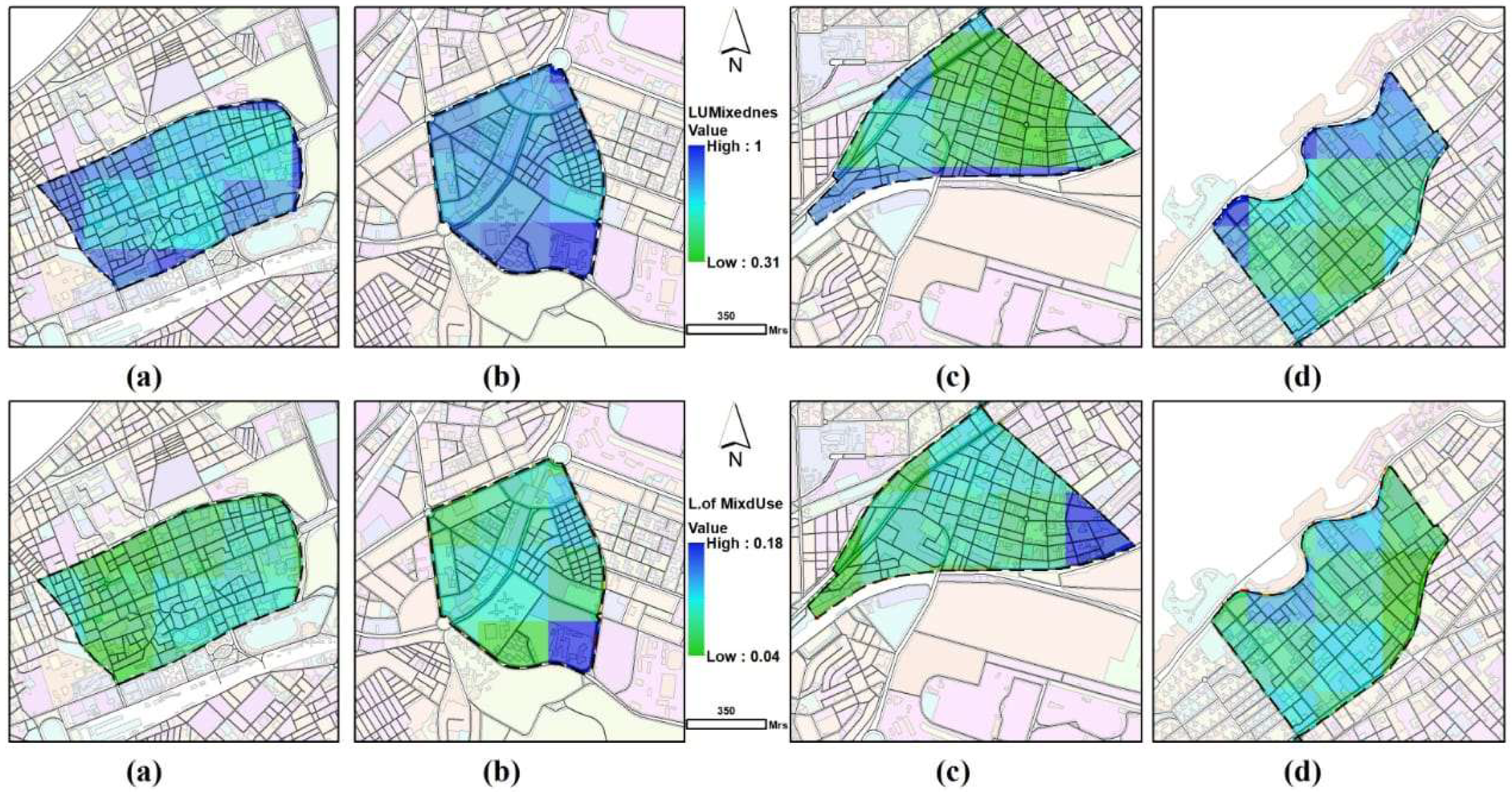
Regarding the calculation of the land-use mixedness, the indicator focused only on the horizontal mix of land uses within the study areas. This indicator measures how different land uses are mixed with residential land use. This indicator has also been used to express the walkability and cyclability of the areas. From the results shown in Figure 6, the highest levels of mixedness are found in the Latin, Smouha, and a few parts of the Kafr–Abdo and Roushdy neighborhoods. Moreover, medium to low values are found in some parts of Kafr–Abdo and Roushdy neighborhoods. The best-balanced mixedness of land use of value 1 implies an equal share of residential land use with other land uses, representing <1% from Latin and Smouha areas, which is a relatively very small percentage.
The level of mixed use is calculated by estimating the number of diverse land uses around each land grid within an easily walkable distance. The land-use diversity indicator is one of the key measures to compile the walkability index; it can show the level of spatial heterogeneity. From Figure 6, it can be seen that a big proportion of the four neighborhoods have a medium to low mixture of land uses with values ranging from 0.04 to 0.18. The Latin and Roushdy neighborhoods lack a high diversity level. There are a number of areas across the four neighborhoods that feature a value of zero as they contain either single-use residential buildings or no diversity at all.
Conversely, some areas in the Smouha and Kafr–Abdo neighborhoods have a slightly higher and more balanced diversity level than the Latin and Roushdy neighborhoods. Notably, they include residential buildings along with commercial, residential–commercial, educational, cultural, security, recreational, sports services, green areas, and infrastructure and facilities. Similarly, the small part of the eastern Kafr–Abdo neighborhood has the highest diversity level, which means a vibrant mix of land uses. It is noted that the increment of diversity indicator values allows for shorter distances to destinations, allowing for more active mobility options like walking and cycling.
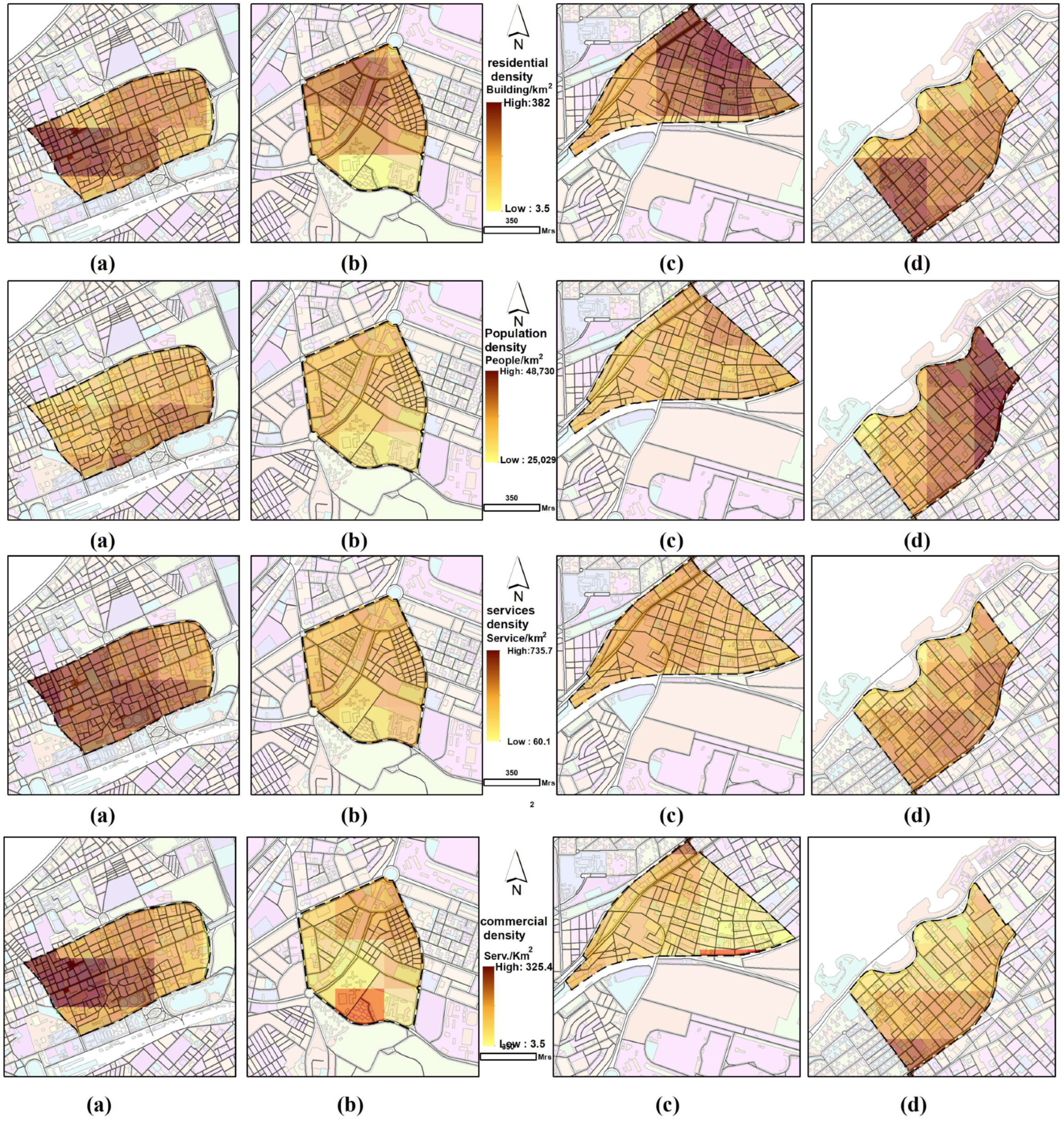
Concerning the residential density, the resulting map Figure 7 shows that the density values are high in the western part of the Latin neighborhood, in the northern part of the Kafr–Abdo neighborhood, and in the southwestern part of the Roushdy neighborhood. This is typically normal because the highest values correspond to the highest average building height across the study areas. The values are quite medium or low across the Smouha neighborhood.
Additionally, it can be seen that a great portion of the four neighborhoods has a medium to low mixture of population density. Given an average household size of 5 people in Alexandria [67] and considering the mean population density of the four study areas is 4877 people per square kilometer, it is evident that the population density across the study areas is relatively low. Nevertheless, Roushdy exhibits the highest average population density at 38,914 persons per square kilometer, which is relatively high considering the urban pattern and residential density of the neighborhood.
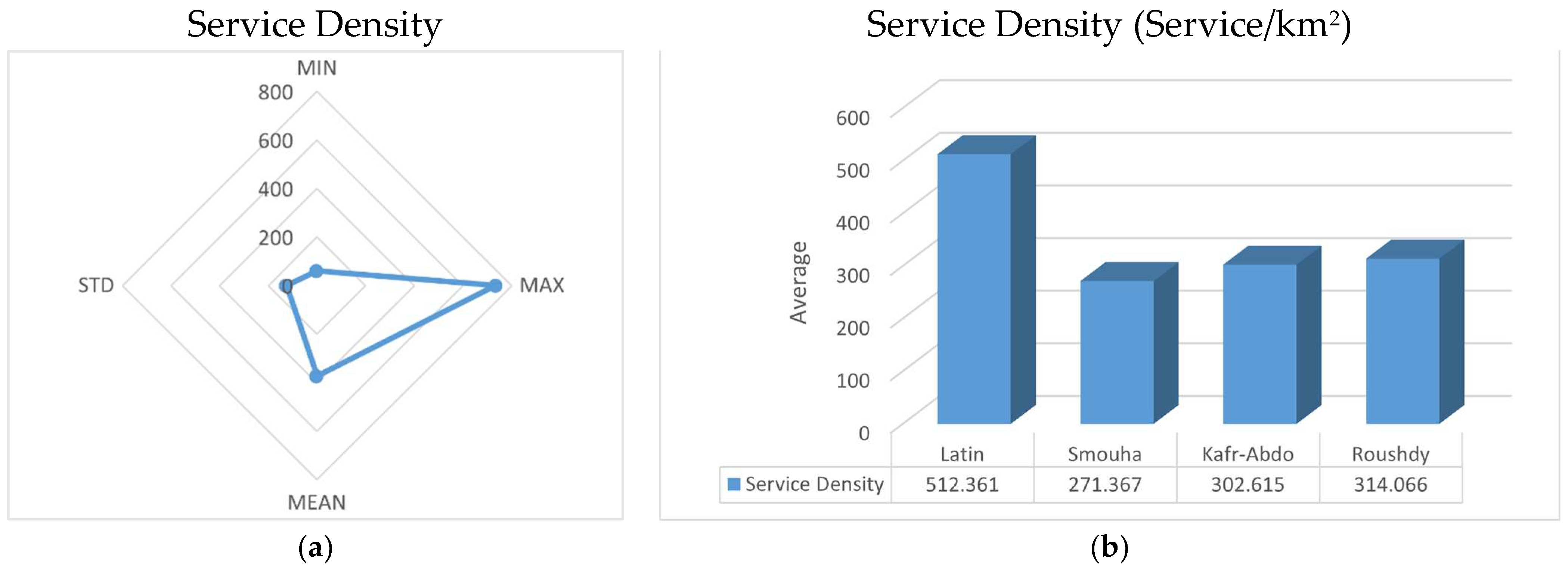
In terms of service density, the Latin neighborhood stands out with the highest average value (512.361 service/km2) across the study area, as illustrated in Figure 7 and Figure 8, whereas Smouha, Kafr–Abdo, and Roushdy exhibit approximate close service densities average. Upon examination, the maximum service density value across the four study areas is determined to be 735.65 service/km2.
After calculating the commercial density as an individual indicator, it is also found that the Latin neighborhood encompasses the highest average value, 137.46 commercial service/km2, followed by Roushdy, 61.78 commercial service/km2, then Smouha, 53.02 commercial service/km2, and finally Kafr–Abdo, 48.41 commercial service/km2.
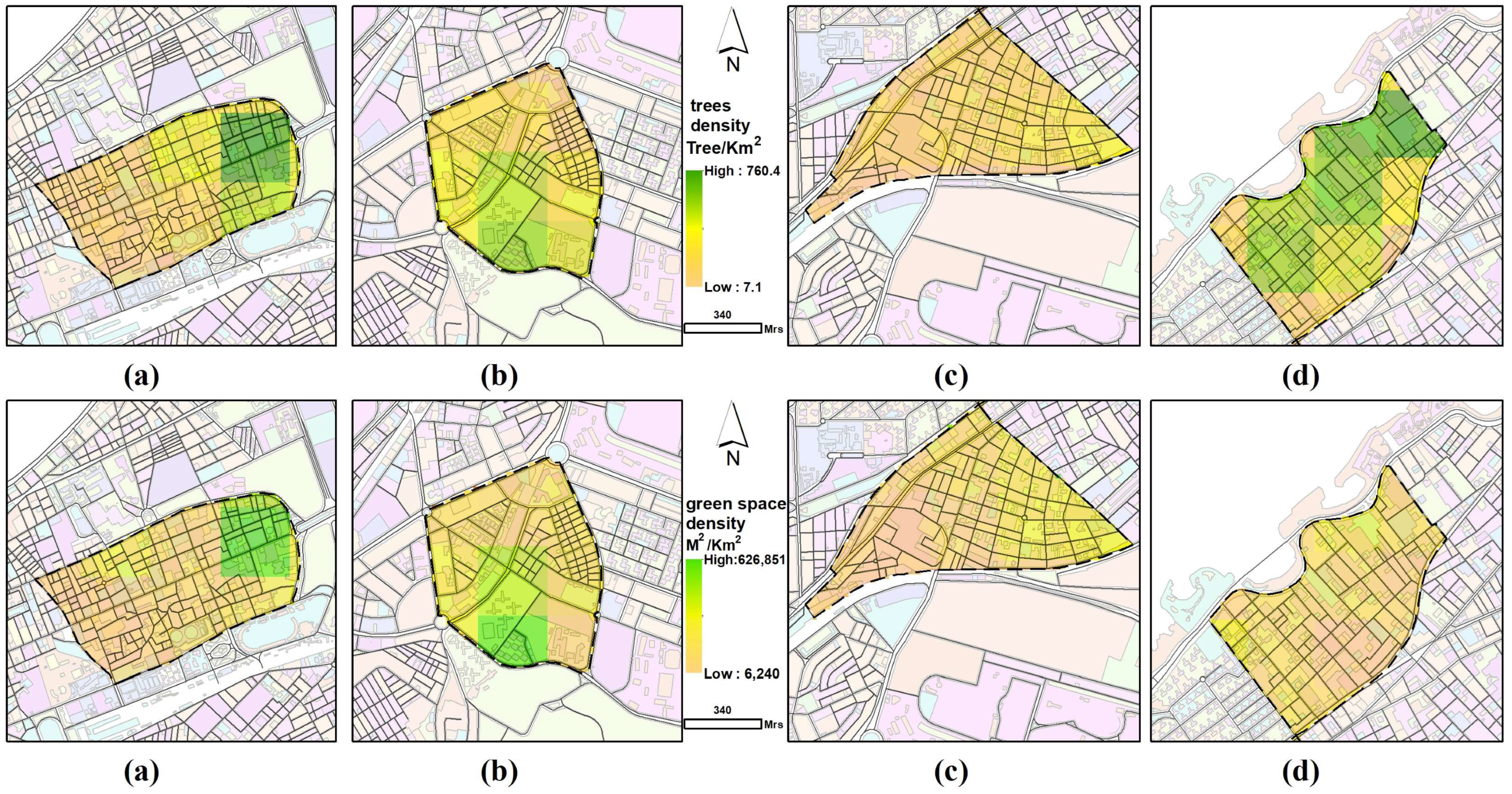
Regarding the density indicator for trees (as depicted in Figure 9), the Latin area exhibits the highest value of 760 trees per square kilometer. It is worth mentioning that the greatest concentrations of tree density are found in close proximity to El-Shalalat Park (a publicly accessible park), along with areas of high green space density. Roushdy demonstrates a moderate to high average tree density of 343 trees per square kilometer, with concentrations notably in the central region of the study area and around old buildings, villas, or palaces such as Prince Abdullah Al-Sabah Palace. On the contrary, Roushdy, along with Kafr–Abdo, exhibits the lowest density of green spaces within the study area. It is noted that the trees are predominantly concentrated along main streets designed for cars rather than pedestrians.
As for the green areas, it was found that they are concentrated in specific locations outside of residential blocks. This has led to a high density of greenery in certain pixels, with certain areas being significantly denser than others. For example, in the Latin Quarter, greenery is concentrated in the eastern part of the neighborhood in close proximity to El-Shalalat Park. In Smouha, the green areas are in the south, concentrated within privately owned land with no direct access to pedestrians. Regarding Roushdy, there are some green spaces, but they are also privately owned and not for public use. In Kafr–Abdo, there are green areas, but they are also associated with villas and private properties. The highest average green area density was found in Smouha, with approximately 193,887 m2 per km2, followed by the Latin Quarter with 130,688 m2 per km2, Roushdy with 110,340 m2 per km2, and Kafr–Abdo with 101,419 m2 per km2.
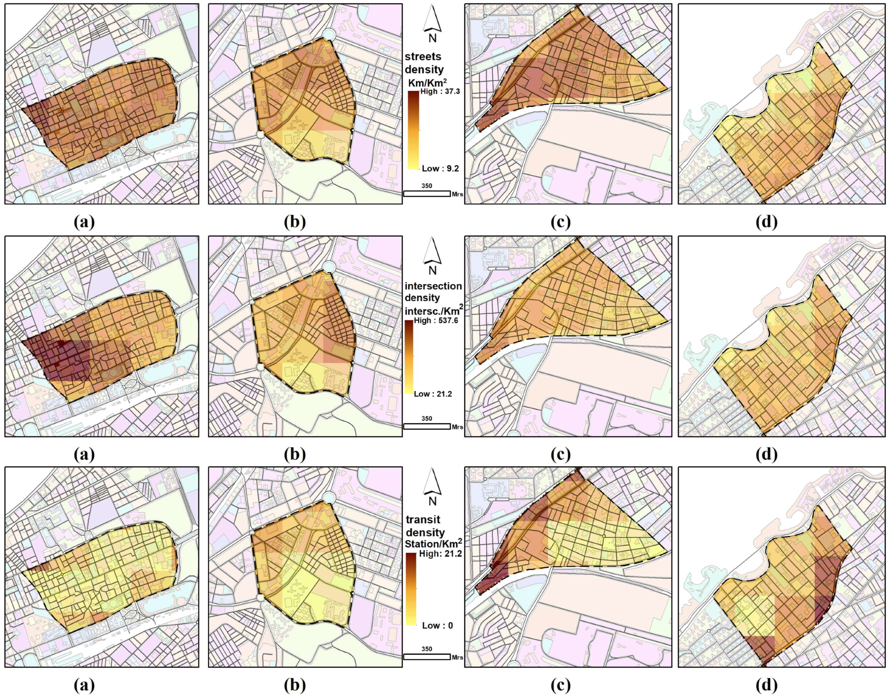
In terms of street density (see Figure 10), the Latin neighborhood boasts the highest average street density at 30.61 Km/km2, followed by Kafr–Abdo, which indicates a medium average value of 26.76 Km/km2, then Smouha and Roushdy.
Once more, the Latin neighborhood exhibits the highest average intersection density, with 277 intersections per square kilometer. The highest values are concentrated in the western part of the neighborhood, particularly along the connection of Fouad Street with Safia Zaghloul Street, which are considered collector residential streets with medium traffic. In contrast, Smouha, Kafr–Abdo, and Roushdy have relatively low average values ranging from 166 to 125 intersection/km2.
In terms of transit density, the highest value recorded is 21.2 transit stations per square kilometer, located in the Kafr–Abdo neighborhood. This is expected, as the Kafr–Abdo study area encompasses one of the largest nodes, housing both the Sidi–Gaber train and tram stations. Following Kafr–Abdo, the Roushdy neighborhood also exhibits high values, as it is bordered by the tram line and its stations to the south.
In terms of distance to transit, it is clear that the distance to the stations is the shortest in the Roushdy area, with an average distance of approximately 175 m. The longest distance is in the Smouha area, with an average distance of around 330 m. In the Latin Quarter, the average distance is 270 m, and in the Kafr–Abdo area, it is 303 m.
In terms of the commercial, population, and service densities, it is evident that there is a relationship between the spatial distribution of the values of the three indicators. Areas with higher population density also have higher commercial and service density. For instance, the Latin Quarter has the highest commercial density because it is clearly a residential area, which necessitates the presence of commercial services to meet the various needs of the residents. It also has the highest service density and is second in terms of population density. Similarly, the Roushdy area has the highest population density and is second in both service and commercial density.
After compiling the results of each indicator, a composite index was achieved to assess the state of walkability of the four areas. Each of the four areas had zones in which the walkability index per cell was high (denoted by the color green) (Figure 11) and other zones that were not walkable (denoted by the color red). The maximum score for the computed index value per cell is 0.66, and the lowest score is 0.14. The largest walkability scale was in the gridiron urban morphology pattern, which is due to its sectoral nodes and high connectivity spots, followed by the linear morphology, then the radial, and lastly, the organic.

6. Discussion

An examination of Figure 4 reveals the locations where high FAR values align with specific urban morphologies. FAR is also investigated as a better indicator of living comfort and justifies these high values in the study area. First, the Sharq district is identified as the city’s second most populous district. Sharq has a vibrant mix of high-quality residences and commercial facilities and features the highest average building height in Alexandria. Although one of the older districts of the urban core zone of Alexandria—Wasat—has fewer high-rises, it contains solidly mid-rise areas of the city (about 10% of buildings are over 9 stories, and 80% are between three and eight stories tall according to [68]).
Given that Smouha, Kafr–Abdo, and Roushdy are nestled within the precincts of Sharq, the observation of medium to high FAR values therein logically follows. However, some parts of Smouha exhibit medium to low FAR values, which corresponds to institutions such as the Faculty of Nursing, the Faculty of Economic Studies and Political Science at Alexandria University, university student dormitories, and the emergency hospital of Smouha University. The Latin neighborhood is located in the Wasat district, which has much older building stock than most of the city. It is considered to be one of the districts in Alexandria’s city center. Consequently, the study area encompasses medium FAR values attributed to old, magnificently decorated traditional buildings, commercial establishments, and governmental and administrative services.
In general, the dominant BCR values are significantly high (Figure 5). Some areas in the Smouha neighborhood were found to be equal to zero as they correspond to football pitches, vacant land, or green areas. Noticeably, there are some areas with anomalously high values in the Latin neighborhoods. The reasons for this could be the disaggregation of data to the grid cells containing the buildings or the quality of data.
Regarding the level of mixed use (Figure 6), in several locations within the four neighborhoods, values of zero are observed because those areas contain only one kind of land use, and the model is set to skip their calculation, and the cell value returns to zero, indicating no diversity at all. The formula used is only valid for areas with more than one land-use type because the value of the natural logarithm function in the denominator would be zero (ln = 0), causing the division error by zero and stopping the calculation process.
The residential density findings (Figure 7) are due to the unplanned and unprecedented boom in construction activities in the wake of the 2011 revolution in Egypt throughout Alexandria due to the lack of law enforcement regarding building codes and regulations. New buildings are squeezed into tiny lots in the core areas of Alexandria, and buildings of historic value were demolished to build larger structures on their sites. This is a dangerous trend, and the city faces the continued loss of its precious historic villas and representative buildings [68].
In terms of street density (Figure 10), the inner streets of the Latin neighborhood form a splendid T-shaped ensemble together with three major roads: Fouad, Salah Mostafa, and Omar Toson. Similarly, Roushdy’s inner streets are T-shaped and perpendicular to three important streets: Al-Moaskar Al-Romani, Abou-Kir, and Tag Al-Rousae. Additionally, the authors evaluated the street categories through observational assessment during the field visits. Three distinct categories of residential streets are identified in the study areas: light residential, residential, and collector residential streets. These streets exhibit homogeneity and are characterized by a medium to high housing standard, with mixed land uses, including residential, commercial, and other land uses. This adheres to the findings of [69,70], which categorized streets into three main types: light residential street, residential street, and collector street, which, in turn, impacts pedestrian activity, thus affecting walkability.
Concerning the composite walkability index results (Figure 11), the reasons behind these results come from the width of the streets, the urban fabric, the land-use density of the areas, and the sidewalk patterns and design. The most common factors that affect the walkability of these areas are sidewalk trespassing, whether through retail extensions, unplanned slopes for entry and exit from garages and basements, inadequate width of the sidewalk, inadequate placement of infrastructure, and absence of shading spots.
The minimum, maximum, mean, and standard deviation were calculated for each of the indicators, as shown in Table 5. It is clear from the data that there is a wide range of areas in regard to service densities, commercial densities, and distance to transit. These items have impacted the walkability index aggregation directly; the lower the densities, the lower the walkability index, and the higher the densities, the higher the walkability index, meaning that the area is walkable.
It is also worth mentioning that although the criteria “presence of sidewalks”, “materials used,” and “appropriate width of sidewalks” were dropped from the spatial mapping, upon direct observation, it was found that most sidewalks are either derelict or in dire need of maintenance, not to mention that they were mainly either too narrow or were trespassed upon. Table 6 shows the correlation between each indicator and the rest of the indicators, thus mapping the effect of each indicator with its analysis parameters and the aggregation of these data according to the formula mentioned in the Section 3.
It is seen that there is a positive correlation between the walkability index and residential density. The study showed that there is a direct relationship between the density of residential buildings and the walkability index (R = 0.43). This relationship indicates that the greater the density of residential buildings, the greater the walkability index, resulting from the fact that with the increase in building density, an increase in the density of streets, intersections, and commercial services that provide the daily needs of residents also inevitably increases. This correlates with studies that have proven the existence of a direct relationship between housing density and population on the one hand and walking on the other hand [71,72].
It is also noted that [73] found intertwined relationships between walking rates and physical activity on the one hand and the characteristics of the built environment on the other hand. The authors found that there are direct relationships between street density and the daily walking rate (r = 0.469) and between intersection density and the daily walking rate (r = 0.488). Likewise, the relationship between street density and the walkability index in the current study was a direct relationship (r = 0.53). This means that the greater the density of the streets, the greater the value of the walkability index. The same applies to intersection density (r = 0.84), where an increase in intersections indicates an increase in the walkability index. This also coincides with the findings of [72].
On the other hand, studies, such as that of [74], found an inverse relationship between the level of mixed use and physical activity based on walkability. Likewise, the current study showed the same type of relationship between these two variables (r = −0.22), and this is due to the low diversity in land uses in all study areas (see Figure 6), where the highest value of the level of mixed use indicator was 0.18, which is a value that indicates that the diversity of land uses within regions is very far from balance, and this results from the randomness of land uses, as there is a positive relationship between the planned diversity of mixed use and walkability [75].
The results also indicate that although the relationship between land-use mixedness and the walkability index in the study areas is a direct one, it is a weak direct (r = 0.11). It is known that land-use mixedness indicates the proportion of residential use relative to other uses, and the closer its value is to 0.5, the more balanced the result. Between residential use and other uses, according to Table 5, the average value of the land-use mixedness index is 0.684, which is closer to balance and means an increase in residential uses relative to other uses, and this is intertwined with the relationship between residential density and walkability index.
The current study also found that the commercial services density and the services density are the indicators most closely related to the walkability index, as the relationship reached (1.0) and (0.82), respectively, meaning that an increase in the density of commercial uses increases the possibility of walking due to its linkage to residential areas, while commercial services are generally concentrated on roads and streets, which makes them more closely related to other indicators such as street density, intersection density, and residential use density. This is proven in a study claiming that higher commercial use density makes their surrounding areas more walkable [76]. This is also seen in the work of [77], which demonstrated the existence of a direct relationship between the density of residential buildings in relation to their built-up area and the walkability index. At the same time, there was a direct weak relationship with FAR; however, the FAR indicator in this study was referring to the ratial floor area ratio. This correlates to the findings of the current study, which found a direct relationship between BCR and Walkability (r = 0.45). This is due to the fact that a higher BCR means an increase in residential use, and thus, the density of streets and intersections, as well as commercial uses, increases with it.
Regarding the transit density indicator, the results of [73] indicate that there is a direct relationship between transit density and the walkability index. The study found that the higher the density of stations, the easier access to mass transit becomes (due to the relatively short distance compared with if the density of stations was less), which in turn decreases the daily walking distance to transportation services. This corresponds to the findings of the present study, which indicated the existence of a direct relationship in which it reached the value of r is 0.07. On the other hand, the greater the distance to the stations, the less the possibility of walking, as the relationship was inverse (r = −0.28).
Concerning the relationship between walking and green areas/trees, the relationship was unexpectedly inverse between the density of green areas/tree density on the one hand and the possibility of walking on the other hand. The relationship was r = −0.39 for the first and r = −0.35 for the second, respectively. This is due to the concentration of green areas in peripheral areas and not within the residential blocks, which makes their value appear only in the boundaries, in addition to the decrease in their areas relative to the area of built-up areas, and also due to the fact that most of them are private green spaces, not public ones, leading ultimately to this negative result. As for the trees, they are more concentrated on the main streets, with a minor presence along inner residential streets. Most are also planted on the middle island between the roads, which means they are intended to improve the landscape and not for pedestrians. This reduces the penetration of these trees into all the streets, although this does not appear in area D (Roushdy), in which trees are planted clearly in the streets due to their proximity to the sea, and this is directed more toward walking and improving the landscape together.
As mentioned in the results, the maximum score for the computed index value per cell is 0.66, and the lowest score is 0.14. The largest walkability scale was in the gridiron urban morphology pattern, which is due to its sectoral nodes and high connectivity spots, followed by the linear morphology, then the radial, and lastly, the organic. This comes as an emphasis on the previously mentioned discussion regarding each density and its direct correlation to the walkability index. The following are sorted decreasingly, from the most impactful to the least impactful of the factors that have the highest correlation: commercial density, intersection density, service density, street density, BCR, and residential density, with the correlation scores being r = 1.0, 0.83, 0.82, 0.53, 0.45, and 0.43, respectively.
The average of the composite walkability index after aggregation of all variables showed that the Latin Quarter had the highest walkability index (0.364), followed by Roushdy (0.247) and Smouha (0.232), with Kafr Abdou coming in last (0.225). This shows that the gridiron morphology is the most walkable, followed by the linear, then the radial, followed by the organic morphology.

7. Conclusions

Walkability is an essential strategy in today’s cities, beneficial not only to citizen’s health and wellbeing but also to the overall quality of life of residents. Urban morphology and urban form heavily impact the walkability of any given area, whether through street connectivity, street design, neighborhood formations, or distance to services and transit. The present study assesses four different neighborhoods in the city of Alexandria, Egypt. Twelve indicators were identified, mapped, and aggregated based on previous empirical research. Then, the 12 indicators were correlated with each other and summed to create a composite walkability index. This walkability index aims to understand the factors that affect walkability in a neighborhood and the relationship between walkability and urban morphology. The aggregated index showed that the highest walkability index was that of the gridiron morphology, followed by the linear morphology, with the radial and organic morphologies coming in last, respectively. The composite index values were 0.364, 0.247, 0.232, and 0.225, respectively. The reason for this is mainly the presence of commercial density, intersection density, service density, BCR, and residential density.
The present research’s limitations are mainly due to the absence of adequate data, as well as the collection and measurement of people’s perception of their preference for walking, as well as the reasons behind this. Also, political and governmental law enforcement regarding trespassing on streets and sidewalks and appropriate distances to services are factors in the readiness to walk. Another point worth mentioning is that the current research is from a spatial point of view, regardless of the behavioral patterns accompanying it.
Further research:
The presence of weighting in the composite index should be further researched to come up with the main variables that affect walkability. This could factor in behavioral aspects as well as spatial ones and should include a sensitivity analysis.
Due to the differences between the different parts of the world, economically, socially, or culturally, as well as in terms of people’s perception and willingness to walk, and bearing in mind walkability patterns, the development of a context-based score is recommended.

Author Contributions

Conceptualization, S.I., A.Y., and S.A.A.-R.; methodology, S.I., A.Y., and S.A.A.-R.; software, S.I. and A.Y.; validation, S.I., A.Y. and S.A.A.-R.; formal analysis, S.I., A.Y. and S.A.A.-R.; investigation, S.I., A.Y. and S.A.A.-R.; resources, S.I., A.Y. and S.A.A.-R.; data curation A.Y.; writing—original draft preparation, S.I., and S. A; writing—review and editing, S.I., A.Y., and S.A.A.-R.; visualization, S.I. and A.Y.; supervision, S.A.A.-R.; project administration, S.I., A.Y., and S.A.A.-R. All authors have read and agreed to the published version of the manuscript.

Funding

This research received no external funding.

Data Availability Statement

No new data were created or analyzed in this study.

Conflicts of Interest

The authors declare no conflicts of interest.

References

  1. Tuominen, A.; Sundqvist-Andberg, H.; Aittasalo, M.; Silonsaari, J.; Kiviluoto, K.; Tapio, P. Building transformative capacity towards active sustainable transport in urban areas–Experiences from local actions in Finland. Case Stud. Transp. Policy 2022, 10, 1034–1044. [Google Scholar] [CrossRef]
  2. Liu, X.; Dijk, M.; Colombo, C. Improving multilevel policy mixes for sustainable urban mobility transition. Environ. Innov. Soc. Transit. 2024, 50, 100808. [Google Scholar] [CrossRef]
  3. Kiviluoto, K.; Tapio, P.; Tuominen, A.; Lyytimäki, J.; Ahokas, I.; Silonsaari, J.; Schwanen, T. Towards sustainable mobility–Transformative scenarios for 2034. Transp. Res. Interdiscip. Perspect. 2022, 16, 100690. [Google Scholar] [CrossRef]
  4. Bedoya-Maya, F.; Calatayud, A.; Mejía, V.G. Estimating the effect of road congestion on air quality in Latin America. Transp. Res. Part D Transp. Environ. 2022, 113, 103510. [Google Scholar] [CrossRef]
  5. ITF. Improving the Quality of Walking and Cycling in Cities: Summary and Conclusions; OECD Publishing: Paris, France, 2024; 70p, Available online: https://itf-oecd.org/improving-quality-walking-cycling-cities (accessed on 3 March 2024).
  6. Gorrini, A.; Presicce, D.; Messa, F.; Choubassi, R. Walkability for children in Bologna: Beyond the 15-minute city framework. J. Urban Mobil. 2023, 3, 100052. [Google Scholar] [CrossRef]
  7. Jackson, R.J.; Kochtitzky, C. Creating A Healthy Environment: The Impact of the Built Environment on Public Health. Director 2010, 20, 78–80. [Google Scholar] [CrossRef] [PubMed]
  8. Lyons, G. Walking as a service–Does it have legs? Transp. Res. Part A Policy Pract. 2020, 137, 271–284. [Google Scholar] [CrossRef]
  9. Gehl, J. Cities for People; Island Press: Washington, DC, USA, 2010; pp. 1–269. [Google Scholar]
  10. Stein, M.; Nitschke, L.; Trost, L.; Dirschauer, A.; Deffner, J. Impacts of Commuting Practices on Social Sustainability and Sustainable Mobility. Sustainability 2022, 14, 4469. [Google Scholar] [CrossRef]
  11. Baobeid, A.; Koç, M.; Al-Ghamdi, S.G. Walkability and Its Relationships With Health, Sustainability, and Livability: Elements of Physical Environment and Evaluation Frameworks. Front. Built Environ. 2021, 7, 721218. [Google Scholar] [CrossRef]
  12. Donnelly, J.E.; Hillman, C.H.; Castelli, D.; Etnier, J.L.; Lee, S.; Tomporowski, P.; Lambourne, K.; Szabo-Reed, A.N. Physical activity, fitness, cognitive function, and academic achievement in children: A systematic review. Med. Sci. Sports Exerc. 2017, 48, 1197. [Google Scholar] [CrossRef]
  13. Rothman, L.; Hagel, B.; Howard, A.; Cloutier, M.S.; Macpherson, A.; Aguirre, A.N.; McCormack, G.R.; Fuselli, P.; Buliung, R.; HubkaRao, T.; et al. Active school transportation and the built environment across Canadian cities: Findings from the child active transportation safety and the environment (CHASE) study. Prev. Med. 2021, 146, 106470. [Google Scholar] [CrossRef] [PubMed]
  14. Ibrahim, S.M.S.Z. The making of creative cities: Exploring the role of sustainable urban mobility (SUM). In Handbook of Research on Creative Cities and Advanced Models for Knowledge-Based Urban Development; IGI Global: Hershey, PA, USA, 2020; pp. 173–196. [Google Scholar] [CrossRef]
  15. Abdel-Razek, S.A. Governance and SDGs in smart cities context. In Smart Cities and the un SDGs; Elsevier: Amsterdam, The Netherlands, 2021; pp. 61–70. [Google Scholar]
  16. Biehl, A.; Stathopoulos, A. Investigating the interconnectedness of active transportation and public transit usage as a primer for Mobility-as-a-Service adoption and deployment. J. Transp. Health 2020, 18, 1847537. [Google Scholar] [CrossRef]
  17. Dovey, K.; Pafka, E. What is walkability? The urban DMA. Urban Stud. 2020, 57, 93–108. [Google Scholar] [CrossRef]
  18. Visvizi, A.; Abdel-Razek, S.A.; Wosiek, R.; Malik, R. Conceptualizing Walking and Walkability in the Smart City through a Model Composite w2 Smart City Utility Index. Energies 2021, 14, 8193. [Google Scholar] [CrossRef]
  19. Shields, R.; da Silva, E.J.G.; Lima, T.L.E.; Osorio, N. Walkability: A review of trends. J. Urban. Int. Res. Placemaking Urban Sustain. 2023, 16, 19–41. [Google Scholar] [CrossRef]
  20. Ren, G.; Zhou, Z.; Wang, W.; Zhang, Y.; Wang, W. Crossing behaviors of pedestrians at signalized intersections: Observational study and survey in China. Transp. Res. Rec. 2011, 2264, 65–73. [Google Scholar] [CrossRef]
  21. Singh, R. Factors Affecting Walkability of Neighborhoods. Procedia-Soc. Behav. Sci. 2016, 216, 643–654. [Google Scholar] [CrossRef]
  22. Ewing, R.; Handy, S. Measuring the Unmeasurable: Urban Design Qualities Related to Walkability. J. Urban Des. 2009, 14, 65–84. [Google Scholar] [CrossRef]
  23. Özbil, A.; Yeşiltepe, D.; Argin, G. Modeling walkability: The effects of street design, street-network configuration and land-use on pedestrian movement. A/Z ITU J. Fac. Archit. 2015, 12, 189–207. [Google Scholar]
  24. Morphology, A.C.U. Urban Morphology/Urban Form. In the Wiley Blackwell Encyclopedia of Urban and Regional Studies; Wiley: Hoboken, NJ, USA, 2019; pp. 1–6. [Google Scholar] [CrossRef]
  25. Barke, M. The importance of urban form as an object of study. In the Urban Book Series; Spring: Berlin/Heidelberg, Germany, 2018; pp. 11–30. [Google Scholar] [CrossRef]
  26. Guastella, G.; Oueslati, W.; Pareglio, S. Patterns of urban spatial expansion in European Cities. Sustainability 2019, 11, 2247. [Google Scholar] [CrossRef]
  27. Inusa, Y.J.; Toe, D.H.C.; Yong, K.W. Urban Form and the Role of Urban Morphological Characters in Town-Plan Regionalization: A Systematic Review. Archit. Urban Plan. 2022, 18, 43–56. [Google Scholar] [CrossRef]
  28. Chen, W.; Noah, A.; Biljecki, F. Classification of Urban Morphology with Deep Learning: Application on Urban Vitality. Comput. Environ. Urban Syst. 2021, 90, 101706. [Google Scholar] [CrossRef]
  29. Boeing, G. Spatial Information and the Legibility of Urban form: Big Data in Urban Morphology. Int. J. Inf. Manag. 2021, 56, 102013. [Google Scholar] [CrossRef]
  30. Rosu, L.I.; Oiste, A.M. Urban Landscape Patterns of Iași City. Analysing City Relations Between Urban Land use, Topography and Inhabitants Pressure Upon Urban Morphology. Bull. UASVMAgriculture 2014, 71, 96–104. [Google Scholar] [CrossRef]
  31. Oyugi, M.O. Is Urban Morphology a Panacea or a Peril to Sustainability? Archit. Res. 2018, 8, 92–102. [Google Scholar]
  32. Amirtham, L.R.; Horrison, E.; Rajkumar, S. Impact of urban morphology on Microclimatic conditions and outdoor thermal comfort-A study in mixed residential neighbourhood of Chennai, India. In Proceedings of the ICUC9-9th International Conference on Urban Climate jointly with 12th Symposium on the Urban Environment Urban Climate Monitoring Networks Based on LCZ Concept, Toulouse, France, 20–24 July 2015. [Google Scholar]
  33. Larkham, P.J. Assessing a quarter-century of Urban Morphology. Urban Morphol. 2022, 26, 173–188. [Google Scholar] [CrossRef]
  34. Raina, S.; Madapur, B.; Raj, M.P. Urban Morphology–Different Attributes that Shape Urban Form. 2018, 1–24. Proceedings of 7th International Conference on Research in Science and Technology, Munich, Germany, 19–21 October 2018. [Google Scholar] [CrossRef]
  35. Williams, K. Urban Form and Infrastructure: A Morphological Review. Future of Cities: Working Paper; 58p, 2014. Available online: https://www.gov.uk/government/uploads/system/uploads/attachment_data/file/324161/14-808-urban-form-and-infrastructure-1.pdf (accessed on 12 November 2023).
  36. Rahman, M. (Ed.) Handbook of Waterfront Cities and Urbanism, 1st ed.; Routledge: London, UK, 2022. [Google Scholar]
  37. Esposito, A.; Grulois, M.; Pappaccogli, G.; Palusci, O.; Donateo, A.; Salizzoni, P.; Buccolieri, R. On the Calculation of Urban Morphological Parameters Using GIS: An Application to Italian Cities. Atmosphere 2023, 14, 329. [Google Scholar] [CrossRef]
  38. Guo, F.; Schlink, U.; Wu, W.; Mohamdeen, A. Differences in Urban Morphology between 77 Cities in China and Europe. Remote Sens. 2022, 14, 5462. [Google Scholar] [CrossRef]
  39. Karimimoshaver, M.; Khalvandi, R.; Khalvandi, M. The effect of urban morphology on heat accumulation in urban street canyons and mitigation approach. Sustain. Cities Soc. 2021, 73, 103127. [Google Scholar] [CrossRef]
  40. Łaszkiewicz, E.; Wolff, M.; Andersson, E.; Kronenberg, J.; Barton, D.N.; Haase, D.; McPhearson, T. Greenery in urban morphology: A comparative analysis of differences in urban green space accessibility for various urban structures across European cities. Ecol. Soc. 2022, 27, 3. [Google Scholar] [CrossRef]
  41. Pattacini, L. Climate and urban form. Urban Des. Int. 2012, 17, 106–114. [Google Scholar] [CrossRef]
  42. Mohsen, H.; Ahmadieh, H. Correlating walkability and urban morphology on Woman’s health using spatial statistical analysis: A comparative study of two neighborhoods in Beirut. Alex. Eng. J. 2019, 58, 945–955. [Google Scholar] [CrossRef]
  43. Ahmed, K.G.; Alipour, S.M.H. More dense but less walkable: The impact of macroscale walkability indicators on recent designs of emirati neighborhoods. City Territ. Archit. 2021, 8, 1–26. [Google Scholar] [CrossRef]
  44. Comer, D.; Greene, J.S. The development and application of a land use diversity index for Oklahoma City, OK. Appl. Geogr. 2015, 60, 46–57. [Google Scholar] [CrossRef]
  45. Cervero, R.; Kockelman, K. Travel Demand and the 3Ds: Density, Diversity, and Design. Transp. Res. Part D Transp. Environ. 1997, 2, 199–219. [Google Scholar] [CrossRef]
  46. Zhao, Y.; Lin, Q.; Ke, S.; Yu, Y. Impact of land use on bicycle usage: A big data-based spatial approach to inform transport planning. J. Transp. Land Use 2020, 13, 299–316. [Google Scholar] [CrossRef]
  47. Boakye, K.; Bovbjerg, M.; Schuna, J., Jr.; Branscum, A.; Mat-Nasir, N.; Bahonar, A.; Hystad, P. Perceived built environment characteristics associated with walking and cycling across 355 communities in 21 countries. Cities 2023, 132, 104102. [Google Scholar] [CrossRef]
  48. Ibrahim, S.M.; Ayad, H.M.; Turki, E.A.; Saadallah, D.M. Measuring Transit-Oriented Development (TOD) levels: Prioritize potential areas for TOD in Alexandria, Egypt using GIS-Spatial Multi-Criteria based model. Alex. Eng. J. 2023, 67, 241–255. [Google Scholar] [CrossRef]
  49. Talen, E.; Compact, J.K. Walkable, Diverse Neighborhoods:Assessing Effects on Residents. Hous. Policy Debate 2014, 24, 717–750. [Google Scholar] [CrossRef]
  50. Caselli, B.; Carra, M.; Rossetti, S.; Zazzi, M. From urban planning techniques to 15-minute neighbourhoods. A theoretical framework and GIS-based analysis of pedestrian accessibility to public services. Eur. Transp. Trasp. Eur. 2021, 85, 1–15. [Google Scholar] [CrossRef]
  51. Koljensic, P. Analysis of 15-Minute City Index Regarding Spatial and Sociodemographic Attributes: Based on a Case Study of Amsterdam. Diploma Thesis, Tongji University Shanghai, Shanghai, China, 2022. Available online: https://repositum.tuwien.at/handle/20.500.12708/136512 (accessed on 12 November 2023).
  52. Fard, P. Measuring Transit Oriented Development (TOD): Implementing a GIS-Based Analytical Tool for Measuring Existing (TOD) Levels; University of Twente, Faculty of Geo-Information Science and Earth Observation (ITC): Enschede, The Netherlands, 2013. [Google Scholar]
  53. Lukman, A. Development and Implementation of a Transit-Oriented Development (TOD) Index around the Current Transit Nodes; University of Twente, Faculty of Geo-Information Science and Earth Observation (ITC): Enschede, The Netherlands, 2014. [Google Scholar]
  54. Ewing, R.; Cervero, R. Travel and the Built Environment: A Meta-Analysis. J. Am. Plan. Assoc. 2010, 76, 265–294. [Google Scholar] [CrossRef]
  55. PopWorld. Available online: www.popworld.com (accessed on 13 January 2024).
  56. Hasan, M.M.; Oh, J.S.; Kwigizile, V. Exploring the trend of walkability measures by applying hierarchical clustering technique. J. Transp. Health 2021, 22, 101241. [Google Scholar] [CrossRef]
  57. Brownson, R.C.; Hoehner, C.M.; Day, K.; Forsyth, A.; Sallis, J.F. Measuring the Built Environment for Physical Activity. State of the Science. Am. J. Prev. Med. 2009, 36, S99–S123.e12. [Google Scholar] [CrossRef]
  58. Thayer, T.C.; Gilliland, S.J.; Measures, G.A.U.W. Cautions, and Associations with Active and Public Transportation across Canada Graduate Program in Geography. 2016. Available online: http://ir.lib.uwo.ca/etd (accessed on 16 November 2023).
  59. Coffee, N.T. Constructing an Objective Index of Walkability. Ph.D. Thesis, The University of Adelaide, Adelaide, Australia, 2005. [Google Scholar]
  60. Mitchell, A. ESRI Guide to GIS Analysis: Vol 2. Spatial Measurements and Statistics 2; ESRI: Redlands, CA, USA, 2009. [Google Scholar]
  61. Akinci, Z.S.; Delclòs-Alió, X.; Vich, G.; Salvo, D.; Ibarluzea, J.; Miralles-Guasch, C. How different are objective operationalizations of walkability for older adults compared to the general population? A systematic review. BMC Geriatr. 2022, 22, 673. [Google Scholar] [CrossRef] [PubMed]
  62. Singh, Y.; He, P.; Flacke, J.; Maarseveen, M. Measuring (TOD) over a region using GIS based Multiple-Criteria Assessment Tools. SPA J. Sch. Plan. Archit. 2015, 19, 1–22. [Google Scholar]
  63. van Eck, J.R.; Koomen, E. Characterising urban concentration and land-use diversity in simulations of future land use. Ann. Reg. Sci. 2008, 42, 123–140. [Google Scholar] [CrossRef]
  64. Zhang, Y.; Guindon, B. Using satellite remote sensing to survey transport-related urban sustainability. Int. J. Appl. Earth Obs. Geoinf. 2006, 8, 149–164. [Google Scholar] [CrossRef]
  65. Singh, Y.J.; Lukman, A.; Flacke, J.; Zuidgeest, M.; Van Maarseveen, M.F.A.M. Measuring TOD around transit nodes-Towards TOD policy. Transp. Policy 2017, 56, 96–111. [Google Scholar] [CrossRef]
  66. Singh, Y.J.; Flacke, J.; Zuidgeest, M.; Van Maarseveen, M.F.A.M. Planning for Transit Oriented Development (TOD) Using a TOD Index Gender Gap in Cities View Project Participatory Modelling to Support Policy Making in Social-Ecological Systems View project. January 2015. Available online: https://www.researchgate.net/publication/290432243 (accessed on 16 April 2024).
  67. CC. A. for P. M. and Statistics, CAPMAS. 2023. Available online: https://www.capmas.gov.eg/ (accessed on 20 September 2023).
  68. Strategic Urban Plan (SUP) Alexandria 2032—Phase one: Detailed City Profile, Volume 2a, General Organization for Physical Planning (GOPP), (June 2014), p. 116. Available online: https://www.as-p.com/projects/general-strategic-master-plan-alexandria-2032-184 (accessed on 14 December 2023).
  69. Smith, R.; Baker, S.; Sharlene, S. Street Design: Part 1-Complete Streets: Public Roads, July/August 2010; p. 3, Federal Highway Administration. Available online: https://www.fhwa.dot.gov/publications/publicroads/10julaug/03.cfm (accessed on 23 February 2024).
  70. Elsawy, A.A.; Ayad, H.M.; Saadallah, D. Assessing livability of residential streets–Case study: El-Attarin, Alexandria, Egypt. Alex. Eng. J. 2019, 58, 745–755. [Google Scholar] [CrossRef]
  71. Forsyth, A.; Oakes, J.M.; Schmitz, K.H.; Hearst, M. Does residential density increase walking and other physical activity? Urban Stud. 2007, 44, 679–697. [Google Scholar] [CrossRef]
  72. Motomura, M.C.N.; da Fontoura, L.C.; Kanashiro, M. Understanding walkable areas: Applicability and analysis of a walkability index in a Brazilian city. Ambient. Construído 2018, 18, 413–425. [Google Scholar] [CrossRef]
  73. Forsyth, A.; Hearst, M.; Oakes, J.M.; Schmitz, K.H. Design and destinations: Factors influencing walking and total physical activity. Urban Stud. 2008, 45, 1973–1996. [Google Scholar] [CrossRef]
  74. Wei, Y.D.; Xiao, W.; Wen, M.; Walkability, R.W. Land use and physical activity. Sustainability 2016, 8, 65. [Google Scholar] [CrossRef]
  75. Foundation, T.P.; Frank, K.; Syntax, S.; SAssiociates, G. “Walkability and Mixed Use: Making Valuable and Healthy Communities,” East Aryshire. [Online]. Available online: https://www.knightfrank.be/research/walkability-and-mixed-use-making-valuable-and-healthy-communities-7667.aspx (accessed on 22 March 2024).
  76. Choi, Y.; Lee, H. Geographic Information System Based Analysis on Walkability of Commercial Streets at Growing Stage. In Proceedings of the 28th CAADRIA Conference, Ahmedabad, India, 18–24 March 2023; pp. 575–584. [Google Scholar] [CrossRef]
  77. Sofwan, M.; Tanjung, M.H. Evaluation Study Of Walkability Index In Central Business District (CBD) Area, Pekanbaru City. J. Geosci. Eng. Environ. Technol. 2020, 5, 175–185. [Google Scholar] [CrossRef]
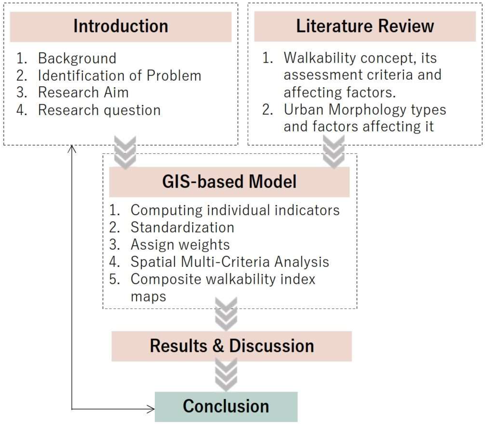
Figure 1. The framework of the research structure. Source: authors.
Urbansci 08 00070 g001
Figure 2. The flowchart illustrates the technical procedures implemented at various stages of the methodology. Source: authors.
Urbansci 08 00070 g002
Figure 3. The street network, built-up density, and the satellite image for the selected study areas (a) Latin Quarter, (b) Smouha, (c) Kafr–Abdo, and (d) Roushdy neighborhoods.
Urbansci 08 00070 g003
Figure 4. The results of calculating FAR for the study areas (a) Latin Quarter, (b) Smouha, (c) Kafr–Abdo, and (d) Roushdy neighborhoods.
Urbansci 08 00070 g004
Figure 5. The results of calculating BCR for the study areas (a) Latin Quarter, (b) Smouha, (c) Kafr–Abdo, and (d) Roushdy neighborhoods.
Urbansci 08 00070 g005
Figure 6. The results of calculating land-use mixedness and the land-use diversity (level of mixed use) for the study areas (a) Latin Quarter, (b) Smouha, (c) Kafr–Abdo, and (d) Roushdy neighborhoods.
Urbansci 08 00070 g006
Figure 7. The results of calculating the residential, population, service, and commercial densities for the study areas. (a) Latin, (b) Smouha, (c) Kafr–Abdo, and (d) Roushdy neighborhoods.
Urbansci 08 00070 g007
Figure 8. (a) The radar chart shows the descriptive statistics of the service density across the four study areas, and (b) the bar chart shows the average values of service density for each study area.
Urbansci 08 00070 g008
Figure 9. The results of calculating tree and green area densities for the study areas are (a) Latin Quarter, (b) Smouha, (c) Kafr–Abdo, and (d) Roushdy neighborhoods.
Urbansci 08 00070 g009
Figure 10. The results of calculating street, intersection, and transit densities for the study areas. (a) Latin Quarter, (b) Smouha, (c) Kafr–Abdo, and (d) Roushdy neighborhoods.
Urbansci 08 00070 g010
Figure 11. The final composite walkability index for the study areas. (a) Latin Quarter, (b) Smouha, (c) Kafr–Abdo, and (d) Roushdy neighborhoods.
Urbansci 08 00070 g011
Table 1. The different types of urban Morphology. Source: adapted by authors from [28,29].
Morphology TypeDescription
GridironA generic grid composed of streets and blocks; buildings are arranged in a linear pattern.
RadialA radial point from which streets radiate outwards.
OrganicIrregular curvilinear lines often flowing with the natural landscape and topography of the area.
LinearLong and narrow, mostly along coastlines and historic cities.
ClusteredA central point around which buildings are arranged in clusters.
SatelliteA group of satellite communities arranged around a central city and connected through transportation routes.
MegastructureCharacterized by large, self-contained structures that contain multiple functions, such as housing, commerce, and transportation.
Table 2. Indicators affecting walkability. Source: adapted from [14,18,19,52,53].
CriteriaIndicators
DensityLand-use mix
Job/Housing Balance
Distance to amenities
Presence of Appropriate mixed uses
Diversity of services
Distance to Transit
Distance to nearest Amenity
Density of Terminals
City transit connectivity
Diversity
Street DesignPresence of resting spots
Streets density
Sidewalk Coverage
Sidewalk DesignPresence of sidewalk
Appropriate width of sidewalk to walk with a friend
Material used for sidewalk
Abrupt stoppages
Presence of a curb
Height of a curb (ease of climbing up or down)
Pathway congestion with obstacles
Presence of adequate ramps and slopes
Appropriate and adequate maintenance
Presence or absence of resting spots
Adequate lighting
Street ConnectivityIntersection density
Roads and intersections
Presence of adequate traffic lights to facilitate crossing
Congestion points and traffic junctures
Pedestrian SafetyDestination Accessibility
Absence of adequate pedestrian spaces
High-speed traffic without appropriate pedestrian crossings or control
Visual and acoustic pollution
Green SpacePresence of shade
Presence of trees and landscaping
Adequate space around trees to walk curbs
Environmental FactorsClimate
Time of Day
Noise Levels
Level of pollutants (PM.2.5, PM 10)
Table 3. Mapping between deduced indicators and the 5 Ds. Source: authors.
CriteriaIndicatorsAdopted or DroppedType of Measure
DensityResidential density *Built
environment
Household/population density *
Employment density *×
Density of services *
Density of streets *
Density of terminals *
Commercial and services density *
Floor area ratio (FAR) *
Building coverage ratio (BCR) *
DiversityLand-use diversity (level of mixed use) *
Job/housing balance×
DesignLand-use mixedness *
Sidewalk coverage×
Presence of sidewalk×
Appropriate width of sidewalk to walk with a friend×
Material used for sidewalk×
Presence of a curb×
Height of a curb (ease of climbing up or down)×
Pathway congestion with obstacles×
Presence of adequate ramps and slopes×
The density of signaled intersections/street crossings *×
Presence of adequate traffic lights to facilitate crossing×
Congestion points and traffic junctures×
Pedestrian safety×
Green space×
Presence of shade×
Presence of trees and landscaping×
Trees Density
Adequate space around trees to walk curbs×
Presence of resting spots×
Destination
Accessibility
Distance to services *
Distance to TransitTransit connectivity *×
Note: Spatial indicators are indicated by an asterisk (*) symbol. The above table also shows the criteria adopted or dropped in the context of this specific research; some of the factors that were dropped were due to lack of availability. (√) Denotes an adopted indicator, while (×) denotes a dropped indicator.
Table 4. The selected neighborhoods for the spatial analysis. Source: the authors.
Neighborhood
Name
Area (m2)District NameMorphology TypeCharacteristics/Main Features
Latin Quarter
Neighborhood
89,000Wasat
(Middle)
Gridiron
  • Surrounded by major roads, on the north by Salah Mustafa Street, on the south by Omar Toson Street, on the west by Safia Zaghloul Street, and on the east intersects with Abu-Kir Street.
  • To the east of the study area lies a significant public green open space known as Shalalat Gardens. To the south of the study area lies Alexandria Stadium, and to the southwest lies the ancient Roman theatre.
Smouha
Neighborhood
90,000Sharq
(East)
Radial
  • Surrounded on the north by Fawzi Moaaz Street, on the south and west by Albert Al-Awal Street, and finally on the east by Al Mahad El-Dini Street.
  • To the south of the study area lies a significant public green open space known as Antoniades Garden, and to the northeast lies a significant square called Victor Amanoiel Square.
Kafr–Abdo
Neighborhood
90,000Sharq
(East)
Organic
  • Surrounded on the north by the Raml tram line, on the south by the Alexandria–Abu-Kir Railway train line and Sidi–Gaber station, and finally, on the east by Kafr–Abdo Street.
Roushdy
Neighborhood
88,000Sharq
(East)
Linear
  • Surrounded on the north by El-Gaish Road located along the shoreline, on the south by Abdel-Salam Aref and Al-Raml tram line, on the east by Mohamed Saleh Abo-Youssef Street, and finally on the west by Al-Moaaskar Al-Romani Street.
Table 5. Minimum, maximum, mean, and standard deviation of each aggregated Indicator. Source: authors.
IndicatorMinimumMaximumMeanStandard Deviation
Walkability Index0.1420.6550.2640.091
BCR0.00185.74461.35614.614
FAR0.007873.516389.061131.363
Level of Mixed Use0.0370.1760.0680.020
Land-Use Mixedness0.3071.0000.6840.169
Service Density60.125735.650372.137124.642
Commercial Density3.6325.3876.2568.4
Residential Density3.537381.972233.92690.340
Population Density2502948730.234910.25562.7
Intersection Density21.221537.590187.16184.106
Street Density9.15937.25326.7224.475
Transit Density0.00021.2213.3593.893
Transit Distance0.000724.614287.605153.887
Trees Density7.074760.407334.042206.563
Green Spaces Density6239.9136850.8136550.6316518.649
Table 6. Correlation between each indicator and the rest of the indicators.
IndicatorsBCRFARLevel of Mixed UseLand-Use MixednessService DensityCommercial DensityResidential DensityPopulation DensityIntersection DensityStreet DensityTransit DensityTransit DistanceTrees DensityGreen Spaces Density
Walkability index0.45−0.01−0.220.110.821.00.430.080.830.530.07−0.28−0.35−0.39
Source: authors.
Disclaimer/Publisher’s Note: The statements, opinions and data contained in all publications are solely those of the individual author(s) and contributor(s) and not of MDPI and/or the editor(s). MDPI and/or the editor(s) disclaim responsibility for any injury to people or property resulting from any ideas, methods, instructions or products referred to in the content.