Abstract
“How far down can it see?” is one of the typical questions when it comes to UAV multispectral remote sensing for archaeology. Since the identification of buried remains is indirect through cropmarks observation, we asked ourselves how deep cropmarks can reveal the buried remains by analysing the complex relationship they have with vegetation. A selected number of contexts of the pre-Roman cities from Falerii and Veii have been studied through agronomic analysis on the one hand and GPR and stratigraphic excavation on the other. The results confirmed the effectiveness of this methodology for land survey, and not only do they demonstrate the ability to identify remains at a greater depth than might have been expected, but they have also made evident the difficulties of environmental analysis, which is crucial at the start of any remote sensing campaign, as well as in the subsequent study of anomalies.
1. Introduction
The democratisation of aerial photography is a relatively recent phenomenon that took its first steps around 2013 with the release on the market of the first easy-to-use UAVs (Unmanned Aerial Vehicles, commonly known as drones) [1]. In the archaeological field, this permitted any scholar to obtain images of their study areas from a different point of view. Leaving aside issues regarding the concomitant development of regulations, which often delayed this process, the new possibilities for detecting anomalies produced by buried evidence of human activities soon began to be tested, often applying the notions inherent in airborne and satellite remote sensing to drone survey. The expansion of the UAV market, the development of new technologies to simplify operations, improve outputs and ensure greater safety, and the parallel spread of free-to-use satellite mapping, allowed drones to take the place of airborne remote sensing in most cases, which is expensive and lacks in following the rhythms of nature to which cropmark and soilmark detection is closely linked. This happened even more with the introduction of miniaturised multispectral and thermal sensors [2]. The change in scale and evolution of sensor technology, however, by demonstrating an entirely new effectiveness in detecting the tiniest and most elusive anomalies produced by buried remains, made clear the need for a greater detachment from derivative techniques [3]. Indeed, increasing the ground sampling distance yields much more information about the dimensional and spectral characteristics of objects, which need to be handled, as recently proposed, with an environmental awareness given by an interdisciplinary approach aimed at improving our understanding of the dynamics involved in cropmark formation [4] (p. 5).
This study aims to investigate the complex relationship that mainly involves buried remains, soil and plants, and that leads to cropmark formation, to try to answer a question that is frequently asked when referring to multispectral remote sensing by drone and that usually finds answers related to erroneous beliefs: “how far down can it see?”. This question is clearly an extreme simplification because buried remains are identified indirectly through cropmarks, which are only surface features. The multispectral sensor obviously does not have the ability to penetrate the ground, but through the acquisition of images for different electromagnetic spectrum bands, including near-infrared, and by using vegetation indices, it can analyse the physiological conditions of plants, which can also be determined by the anthropogenic disturbance of subsoil.
The most common answer is that it is only possible to identify anomalies related to elements buried within a few centimetres of depth, perhaps 30–40 [5] (p. 3). The two-dimensionality of the remote sensing data obviously limits the understanding of the matter and it is, therefore, necessary to adopt a multimodal and interdisciplinary approach and flip the perspective by asking how far down an anthropogenic remain can still alter plant physiology. In an attempt to comprehensively answer this question, the data collected in the research carried out at Falerii Veteres and Veii by the Academic Discipline Civiltà dell’Italia preromana ed Etruscologia of the Department of Science of Antiquities at Sapienza University of Rome are discussed.
2. Materials and Methods
Veii lies above a broad raised tuff plateau of about 190 ha that is shaped by modest hills. After its final abandonment around the middle of the 3rd century AD, the area was mostly exploited for agricultural purposes and today is characterised by a multitude of crops, pastures and some woods in the less accessible areas [6].
Similar morphological and geological features occur at Vignale, the minor of the two plateaus where Falerii Veteres once stood, which suffered the same fate after it was abandoned in 241 BC for the Roman foundation of Falerii Novi [7]. Vignale has an area of about 12 ha and has an elongated shape sloping in a northeasterly direction. It includes tree crops, meadows and a field usually cultivated as herbage, in which the research and then the excavation campaign were concentrated.
In both sites, drone multispectral remote sensing has been conducted for several years combined with other non-invasive methods, with the study of historical aerial photographs and the review of excavation documents, often unpublished and preserved in the archives [8].
At Veii, after a first test in 2017, flights have been carried out since 2020 and led to noteworthy results [4]. Since 2021, by means of a PhD project, drone survey has been conducted systematically and extensively, making it possible to repeatedly cover an area of about 600 ha in 2022 [9]. Three points of the plateau are considered here to verify the drone-detected cropmarks: two placed to the northwest in the Campetti toponym, corresponding to two trenches carried out in the early 2000s by the Unità Operativa Topografia Antica at Sapienza University [10], and one to the southeast in the Piano di Comunità toponym, immediately north of the excavation of the Chair of Etruscologia e Antichità italiche at Sapienza University [11], in which a Ground Penetrating Radar (GPR) survey was completed in July 2020.
Multispectral imaging performed at Vignale in 2020 and 2021 has come to define a particularly complex subsoil situation. In this study, we consider two zones where we have the results of the GPR survey in July 2021 [8] and a direct assessment from the first excavation campaign in June 2022 by the Chair of Civiltà dell’Italia preromana at Sapienza University, which was planned also on the basis of non-invasive investigations (Figure 1).
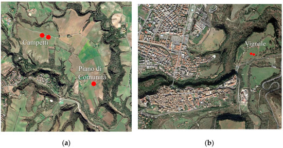
Figure 1.
The two sites and related case studies (a) Veii; (b) Falerii.
The remote sensing and GPR technologies used at Veii and Vignale since 2020 are the same: a Phantom 4 Multispectral with an integrated camera equipped with five mono-band and one RGB sensors and an RTK GNSS; a STREAM-X multichannel acquisition GPR with 600 Mhz antenna box mounted on an aluminium cart equipped with a LEICA G19 GNSS used by Lorenzo Lambiase.
In the cases listed, remote sensing was performed on plots with different crops, the characteristics of which were carefully analysed along with the weather conditions of the period, since these are the elements directly related to the potential of the technique under review.
3. Results and Discussion
At Veii, the two trenches carried out on the southern edge of the existing road crossing Campetti made it possible to unearth several remains related to the Etruscan and Roman periods [10]. Although there is not yet a comprehensive publication of the excavation records and it is difficult to read the findings on the field due to their condition of preservation, it is possible to achieve some valuable information for our purpose.
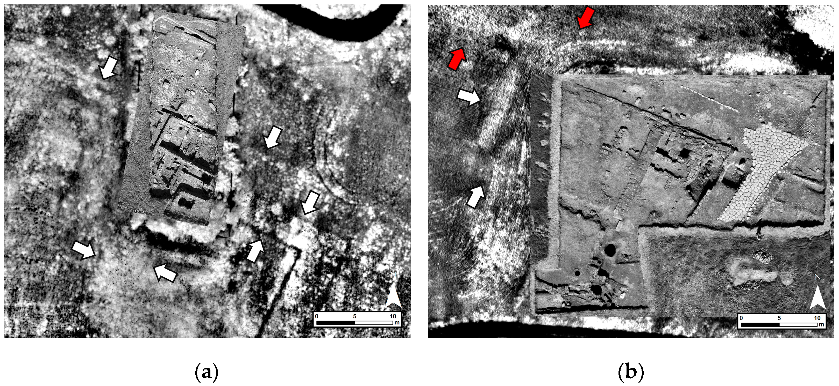
In the easternmost trench, the corner of a two-story building in opus reticulatum and opus latericium was found. The continuations of the walls of this building were detected in the flights of 16 May 2020 and 18 May 2021, on wheat and ryegrass crops, respectively, and even more so on 19 April 2022 on herbage (Figure 2a). The construction technique using opus caementicium that characterises it appears to impede the full development of the plant’s root system, resulting in distinct negative cropmarks, despite the small thickness of the masonry of about 50 cm and its burial depth of about 50–80 cm.

Figure 2.
Aerial photos of Campetti excavations [10] overlaid on index maps showing cropmarks (a) Eastern trench on DVI (Difference Vegetation Index) map 2021; white arrows indicate the building in opus caementicium. (b) Western trench on SR (Simple Ratio) map 2020; red arrows indicate the road and white arrows indicate the foundations made of tuff blocks.
In the westernmost trench, instead, we focus on a segment of the main road axis of the ancient city found with the paving stones of the Roman period removed in antiquity, the continuation of which is partially visible with a mixture of positive and negative cropmarks in the 16 May 2020 flight on wheat, despite that it is situated at a depth of about 80 cm [10] (p. 34), [12] (p. 10, Figure 7). The remains of the foundations of a large building made of tuff blocks were also found at a depth of around 50 cm (Figure 2b). Also in this case, in the same flight, the still-buried part of the building was identified, with a positive cropmark almost 2 m wide produced by the moisture retained by the porosity of the tuff, which delayed the ripening, in contrast to what was observed for the opus reticulatum and latericium [9].
In both cases, it should be noted that the lack of excavation data and only field inspection in the present state of conservation could leave some uncertainties, including the possibility that the still buried parts could be slightly closer to the surface than they appear from the examination of the excavated elements.
The case of Piano di Comunità offers more certainty in this regard. Here, it was decided to verify with GPR a well-defined almost rectangular positive cropmark of around 9.7 m × 4.2 m, previously identified (Figure 3). This method detected to a depth of 45 cm, a target that overlaps with the anomaly identified with the flight of 16 May 2020.
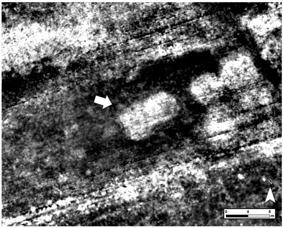
Figure 3.
Positive cropmark at Piano di Comunità area.
In the case of Vignale, in Falerii, the data presented are even more remarkable as they result from ground truth verification of the anomalies identified by drone and partially by GPR. The previous non-invasive surveys carried out by the British School at Rome in the early 2000s [13], which do not provide information related to the depth of the anomalies, are left aside.
As mentioned above, in addition to the multispectral imaging on 22 May 2020 and 15 May 2021 both on herbage and the GPR mapping in July 2021 on a field of about 6800 m2 to the southwest of the plateau, a first excavation campaign started in June 2022 as part of the broader Falerii Project, which aims at a comprehensive approach of the ancient city. Therefore, two trenches were opened according to the identified anomalies, the study of the past research and the results of the field survey carried out in November 2020. Although only three weeks of excavation have been carried out so far, it was possible to obtain useful data for our purposes. Trench no. 1, the westernmost, was placed on a complex anomaly detected both by GPR and remote sensing, which was reached at a depth between 50 and 60 cm and only superficially investigated. This turned out to be the remains of a complex structure made of tuff blocks which can be referred to as the Hellenistic period, at least in the phase of attendance under investigation, for which it is not yet possible to give an interpretation.
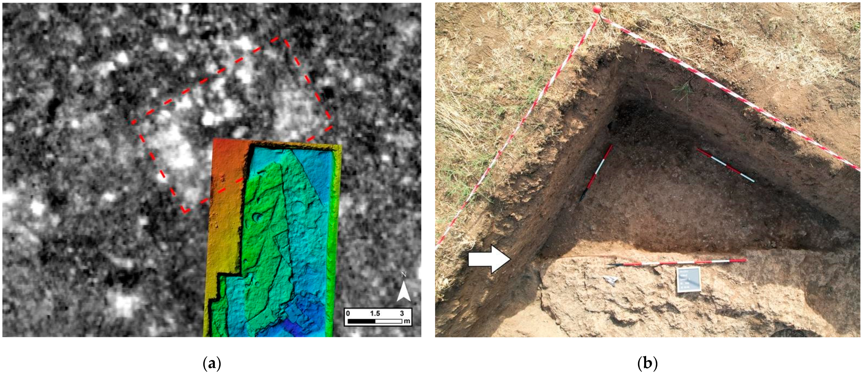
The most interesting data came from trench no. 2, located to the south-east of the previous one in order to investigate a small portion of a large reversed ‘T’-shaped cropmark that was not spotted by GPR and that in its best identifiable southern part consists of a sort of rectangle measuring over 9 m × 5 m (Figure 4).
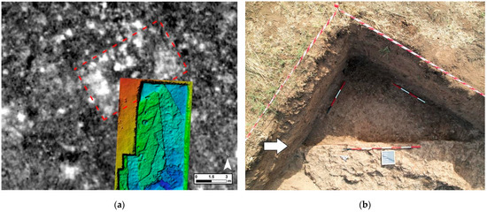
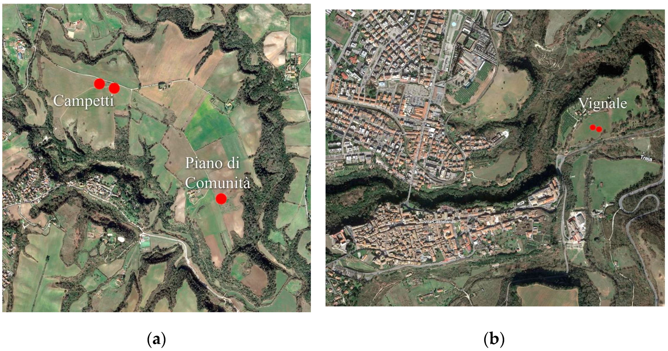
Figure 4.
Vignale trench no. 2. (a) DEM (Digital Elevation Model) of the trench positioned on the large positive cropmark identified (red dotted box); (b) The white arrow indicates the tuff cut corresponding to the southern limit of the cropmark indicated in the left image.
During the excavation, after reaching the tuff bank, in the exact correspondence of the known cropmark in the north-west corner a straight cut in the tuff was found at a depth of between 80 cm and 1 m. As expected, this cut continued beyond the limits of the excavation and whose depth limit has not yet been reached. The layers that fill it, which have only been partially excavated, can be preliminarily dated to the 7th century BC. This thus testifies to the potential of multispectral remote sensing to detect buried remains up to a significant depth.
In order to understand the processes that led to the results just discussed, it is necessary to analyse the elements involved on a case-by-case basis: the plant species and their root system, their phenological stage, the long-term weather conditions and the type of cropmark. The physical characteristics of the soil, which are particularly similar in the presented case studies and therefore not a variable in the comparison are not mentioned, although they are certainly crucial, especially in terms of permeability and texture.
As mentioned above, the crops cultivated in the case studies were durum wheat (Triticum durum Desf.), ryegrass (Lolium multiflorum Lam.) and herbage, which is characterised by a variable mix of species. Wheat and ryegrass have a similar fasciculated root system, which usually extends in depth in the first 30–35 cm where the concentration of nutrients is higher. Some roots, however, continue vertically up to 150 cm or more [14] (p. 1661). The tendency to develop deeper roots may be due to genetic factors, as well as to nutrient deficiency in the top layer of soil, resulting in a deeper search. The availability of water in the different growth stages is also crucial and can result in a reduction or increase in both plant and root biomass.
Genetics is an element that clearly distinguishes the two species and can complicate both the emergence and observation of cropmarks. Cultivated wheat is an autogamous plant consisting of genetically identical individuals and usually showing good homogeneity; the allogamy of ryegrass, on the other hand, is the cause of genetically different individuals. This implies that one can find growing plants with underdeveloped roots at the same time as others that are at the end of their life cycle. For this reason, ryegrass is indeed less suitable than wheat, not only to show more defined cropmarks, but also to reveal deeper elements. The case of herbage is much more complex as it is composed by several species with different characteristics. In this case, there is maximum heterogeneity, and it is not possible to go any further in our analysis. However, since in this case it is also composed at least in part of ryegrass and some other plants with a similar structure, it is assumed that there are some similarities in the development of the root system, also given the remarkable results achieved in Vignale [9].
At Veii, except on 19 April 2022 when the herbage was on average in the growth phase, in the remaining years the crops were in ripening, which was most advanced in the case of wheat in 2020. Instead at Vignale, the phenological stage of the different plants in the herbage cannot be univocally defined, but they generally showed an advanced yellowing.
Weather conditions have a major influence on vegetation growth, thus affecting the relationship between plants and buried remains [15] (p. 194). In our cases, temperature and rainfall were monitored since the autumn sowing. The data show that the 2019/2020 season was characterised by a lower average monthly rainfall than the following 2020/2021 season. The resulting long-term water stress probably led plants to search deeper for water and increased intra-field differences, including those due to buried remains. This explains the situation found in 2020 in the western trench at Campetti and at Piano di Comunità where positive cropmarks were observed, which are easier to distinguish in dry conditions and when the plants are in a stage of advanced ripening, indicating a delay in yellowing compared to the rest of the field. The negative cropmarks identified in the eastern trench at Campetti, on the other hand, are due to a delayed growth of ryegrass in 2022 and to an early yellowing in 2021 for the presence of buried masonry that limited water content and root development. In 2022 this phenomenon was emphasised by a great drought during the winter that lasted until April, which further reduced plant growth [9].
Regarding Vignale, both cropmarks were positive due to the same phenomena just described for 2020 at Veii. The size of the buried remains, as in the case of the Campetti road, was crucial in the occurrence of the cropmark despite the typical heterogeneity of the herbage and the depth of burial.
4. Conclusions
Based on what has been presented, it would seem possible to assume a correlation between the type of buried remain and the chance of locating it at a greater or lesser depth. To observe deeper remains, it seems that there must be a period of drought that would inactivate the more superficial roots of the plants and induce them to use their deeper roots more. Therefore, given a condition of water stress in the presence of a deeply buried ancient remain, indicatively more than 50 cm and especially after a period of enough rainfall to make the roots expand more in depth, two cases may occur: either the deeper roots could reach a moisture accumulation that would allow the plant to stay green longer, or they could be obstructed. In the first case, especially at the end of the crop cycle, a positive cropmark will occur, clearly noticeable in a situation of general water deficiency. In the second case, it would be harder to spot a change in the physiological status due to widespread yellowing, except in the event of a particularly massive buried remain that has limited plant growth already and anticipated the yellowing even further. The use of a multispectral camera can certainly make it possible to analyse differences that are invisible to the naked eye, but it would seem logical to conclude that it is more frequent to identify deeper remains if they are related to moisture accumulation that results in a positive cropmark.
When the plants are still young and not fully formed, the root system can be influenced above all by more superficial remains that block their development, either by acting as a physical obstacle or by causing a reduction in the water and nutrient content of the soil or vice versa by causing waterlogging, which if it is intense and prolonged can arrest root expansion and lead to fungal diseases.
Given the considerations based on the data presented, and despite the complexity of the topic due to the many factors involved that cannot always be defined [15], it is possible to try to answer the starting question, although with some caution; multispectral remote sensing can investigate the subsoil at greater depths down to at least one meter, which is more than one might have expected, but potentially even deeper based on root development, mainly in a dry period and during ripening, especially when the latter is advanced.
As it has been recognised, however, results can vary significantly depending on the plant species involved, the environmental situation and weather conditions; the need for an agronomy-based approach is now evident, as plants are the main target of multispectral remote sensing and only indirectly reveal the evidence of human activity. Hence, an interdisciplinary approach is considered imperative, both in terms of achieving a prediction of the research potential as well as in the study phase to fully understand the outcomes and improve their interpretation.
For the in-depth study of the topic presented, it is hoped that the number of excavation trials based on the cropmarks identified will increase by also investigating different environments for plant species and soil, but also that experimental archaeology, which has already proven in the past to contribute successfully to these kind of studies [16], will be systematically resumed.
Funding
This research received no external funding.
Institutional Review Board Statement
Not applicable.
Informed Consent Statement
Not applicable.
Data Availability Statement
The raw data supporting the conclusions of this article will be made available by the author on request.
Conflicts of Interest
The author declares no conflicts of interest.
References
- Argyrou, A.; Agapiou, A. A Review of Artificial Intelligence and Remote Sensing for Archaeological Research. Remote Sens. 2022, 14, 6000. [Google Scholar] [CrossRef]
- Adamopoulos, E.; Rinaudo, F. UAS-Based Archaeological Remote Sensing: Review. Drones 2020, 4, 46. [Google Scholar] [CrossRef]
- Fiorini, L.; Materazzi, F. Un Iseion a Gravisca? Fotogrammetria, Telerilevamento Multispettrale da APR e dati Archeologici per una Possibile Identificazione. FOLD&R FastiOnLine Doc. Res. 2017, 396. Available online: https://www.fastionline.org/docs/FOLDER-it-2017-396.pdf (accessed on 1 February 2024).
- Materazzi, F.; Pacifici, M. Archaeological Crop Marks Detection through Drone Multispectral Remote Sensing and Vegetation Indices: A New Approach Tested on the Italian Pre-Roman City of Veii. J. Archaeol. Sci. Rep. 2022, 41, 103235. [Google Scholar] [CrossRef]
- Forte, M.; Trinks, I.; Hinterleitner, A.; Klein, M.; LoPiano, A.; McCusker, K.; Schiel, H.; Schlögel, I.; Trausmuth, T.; Vonkilch, A.; et al. Multimodal Remote Sensing Applications in the Etruscan-Roman City of Vulci. J. Field Archaeol. 2022, 47, 501–521. [Google Scholar] [CrossRef]
- Tabolli, J.; Cerasuolo, O. Veii; University of Texas Press: Austin, TX, USA, 2019. [Google Scholar] [CrossRef]
- De Lucia Brolli, M.A.; Biella, M.C.; Suaria, L. Civita Castellana e il suo Territorio, Ricognizioni Archeologiche e Archivistiche; Officina: Roma, Italia, 2013. [Google Scholar]
- Biella, M.C.; Carlucci, C.; De Lucia Brolli, M.A.; Giuliani, B.; Lambiase, L.; Ligabue, G.; Materazzi, F.; Pacifici, M. Falerii, Località Vignale. La Ripresa Delle Indagini in Un Settore Strategico Della Città Antica. Sci. Dell’antichità 2022, 28, 77–105. [Google Scholar]
- Materazzi, F.; Pacifici, M. From Top to Bottom. Multispectral Remote Sensing and Data Integration to Rediscover Veii. FOLD&R FastiOnLine Doc. Res. 2024, 577. Available online: https://www.fastionline.org/docs/FOLDER-it-2024-577.pdf (accessed on 1 February 2024).
- Jaia, A.M.; Cella, E. Paesaggi Urbani a Veio. Saggi di Scavo della Sezione Topografia Antica della Sapienza. In Proceedings of the Novità Nella Ricerca Archeologica a Veio. Dagli Studi di Ward-Perkins alle Ultime Scoperte, Roma, Italy, 18 January 2013; Cascino, R., Fusco, U., Smith, C., Eds.; Sapienza Università Editrice: Roma, Italy, 2015; pp. 34–40. [Google Scholar]
- Michetti, L.M.; Biella, M.C.; Belelli Marchesini, B.; Toppetti, F.; Sarracino, D.; Bischeri, M.; Pacifici, M.; Stomeo, L.; Bianchi, L. Novità Dall’area Urbana Di Veio. Recenti Indagini Nel Distretto Meridionale. Sci. Dell’antichità 2020, 26, 61–94. [Google Scholar]
- Fuldain González, J.; Varón Hernández, F. NDVI Identification and Survey of a Roman Road in the Northern Spanish Province of Álava. Remote Sens. 2019, 11, 725. [Google Scholar] [CrossRef]
- Carlucci, C.; De Lucia Brolli, M.A.; Keay, S.; Millett, M.; Strutt, K. An Archaeological Survey of the Faliscan Settlement at Vignale, Falerii Veteres (Province of Viterbo). Pap. Br. Sch. Rome 2007, 75, 39–121. [Google Scholar] [CrossRef]
- Gojda, M.; Hejcman, M. Cropmarks in Main Field Crops Enable the Identification of a Wide Spectrum of Buried Features on Archaeological Sites in Central Europe. J. Archaeol. Sci. 2012, 39, 1655–1664. [Google Scholar] [CrossRef]
- Czajlik, Z.; Árvai, M.; Mészáros, J.; Nagy, B.; Rupnik, L.; Pásztor, L. Cropmarks in Aerial Archaeology: New Lessons from an Old Story. Remote Sens. 2021, 13, 1126. [Google Scholar] [CrossRef]
- Agapiou, A.; Hadjimitsis, D.G.; Georgopoulos, A.; Sarris, A.; Alexakis, D.D. Towards an Archaeological Index: Identification of the Spectral Regions of Stress Vegetation Due to Buried Archaeological Remains. In Lecture Notes in Computer Science 7616, Proceedings of the Progress in Cultural Heritage Preservation. EuroMed 2012, Lymassol, Cyprus, 29 October–3 November 2012; Ioannides, M., Fritsch, D., Leissner, J., Davies, R., Remondino, F., Caffo, R., Eds.; Springer: Berlin/Heidelberg, Germany, 2012; pp. 129–138. [Google Scholar] [CrossRef]

Disclaimer/Publisher’s Note: The statements, opinions and data contained in all publications are solely those of the individual author(s) and contributor(s) and not of MDPI and/or the editor(s). MDPI and/or the editor(s) disclaim responsibility for any injury to people or property resulting from any ideas, methods, instructions or products referred to in the content. |
© 2024 by the author. Licensee MDPI, Basel, Switzerland. This article is an open access article distributed under the terms and conditions of the Creative Commons Attribution (CC BY) license (https://creativecommons.org/licenses/by/4.0/).