Article

Fuel Drivers of Fire Behaviour in Coastal Mallee Shrublands

1
School of Science, RMIT University, Melbourne, VIC 3000, Australia
2
South Australian Country Fire Service, Adelaide, SA 5000, Australia
3
Natural Hazards Research Australia, Melbourne, VIC 3000, Australia
4
Covey Associates, Maroochydore, QLD 4558, Australia
*
Author to whom correspondence should be addressed.
Fire 2024, 7(4), 128; https://doi.org/10.3390/fire7040128
Submission received: 24 January 2024 / Revised: 30 March 2024 / Accepted: 3 April 2024 / Published: 9 April 2024

Abstract

:
Coastal mallee shrubland wildfires present challenges for accurately predicting fire spread sustainability and rate of spread. In this study, we assess the fuel drivers contributing to coastal mallee shrubland fires. A review of shrubland fire behaviour models and fuel metrics was conducted to determine the current practice of assessing shrubland fuels. This was followed by workshops designed to elicit which fuel structural metrics are key drivers of fire behaviour in coastal mallee shrublands. We found that height is the most commonly used fuel metric in shrubland fire models due to the ease of collection in situ or as a surrogate for more complex fuel structures. Expert workshop results suggest that cover and connectivity metrics are key to modelling fire behaviour in coastal mallee shrublands. While height and cover are frequently used in fire models, we conclude that connectivity metrics would offer additional insights into fuel drivers in mallee shrublands. Future research into coastal mallee fire behaviour should include the measurements of fuel height, cover, and horizontal and vertical connectivity.

1. Introduction

Coastal mallee shrublands are particularly prone to destructive wildfires which negatively affect human lives, infrastructure, property, agriculture, forestry and ecological values [1,2]. While prescribed burning can be an effective mitigation of large wildfires in mallee shrublands if undertaken at sufficient scale [3], limited burns have been undertaken in coastal mallee shrublands outside of large wildfire events partially owing to the lack of a suitable fire behaviour model for this fuel type.
The term mallee refers to multi-stemmed eucalypts with a lignotuber root system and to the ecosystems which are dominated by mallee species [4,5,6]. Mallee shrublands occur in semi-arid Mediterranean climates of Australia (mild wet winters, hot dry summers). Coastal mallee shrublands are found mostly on Kangaroo Island, the Eyre Peninsula and the Yorke Peninsula in South Australia [5,7,8]. Mallee shrublands are characterised by relatively short (2 to 6 m) multi-stemmed eucalyptus tree overstorey and sparse shrubby understorey [9]. Coastal mallee shrublands share the short mallee form of eucalypt overstorey, similar to open semi-arid mallee shrublands, but have higher canopy cover and denser shrubby understorey [10] which provides increased fuel continuity for fire spread. Figure 1 show archetypes of open semi-arid mallee (a and b) and coastal mallee (c and d), highlighting the difference in vertical and horizontal continuity. Coastal mallee shrublands are considered a subset of MVG14 (mallee woodland and shrublands) in the National Vegetation Information System (NVIS) [4]. The term “coastal mallee” is used to describe the ecosystem of denser mallee vegetation, as they tend to occur within 20 km of the coast in higher rainfall areas; however, they are not specifically limited to the coast. “Coastal mallee” is also the common name of Eucalyptus diversifolia, one of the species which makes up coastal mallee shrublands [5].
Several detailed reports have floristically distinguished different mallee vegetation associations across South Australia [7,8,11]. These ecological distinctions cover a wide range of fuel arrangements and continuity. From a fire modelling perspective, coastal mallee shrublands are distinguished from sparser semi-arid mallee shrublands due to the different fire spread thresholds. Several studies have specifically investigated the fire behaviour and spread of both wildfires and prescribed burns in semi-arid mallee shrublands [6,12,13,14]. The primary fuel parameters affecting fire spread sustainability in semi-arid mallee is horizontal discontinuity of fuels and vertical discontinuity to a lesser extent [6,12,13].
In fire-prone Mediterranean landscapes, undertaking prescribed burns adjacent to the values being protected is desirable to mitigate the risk of socio-economic losses from unplanned wildfire [15]. However, this brings an increased risk of negative impacts should a planned fire exceed the boundaries. The risk of burn escape can be effectively managed through confidence in fire behaviour prediction and the prescribed weather and fuel conditions. However, prescribed burn practitioners have reported that the most recent fire spread probability model developed for semi-arid mallee [12] does not perform well in coastal mallee shrublands (Aaron Macumber, Fire Management Officer, National Parks and Wildlife Service South Australia, personal communication). The poor fit of models designed for semi-arid mallee is not surprising given that the canopy cover of coastal mallee is typically 30–70%—well outside the bounds of the empirical fire model (4–19% canopy cover) [12]. This is illustrated by Figure 2, which highlights that as fuel patches in shrublands become more discontinuous, higher wind speed and/or lower fuel moisture is required to sustain fire spread [6,12,13]. This discontinuity is believed to play a crucial role in driving fire behaviour in coastal mallee; however, it is unclear which continuity fuel metrics should be measured.
The need for a suitable fire spread probability model for guiding prescribed burns and validation of rate of spread models for wildfires in coastal mallee has led the authors to ask, “what are the fuel metrics driving fire spread in coastal mallee shrublands”? To answer this question, we first look at other empirical fire models developed for analogous Mediterranean climate shrublands to develop a list of fuel metrics. We then explore the questions further by holding a small series of workshops with fire practitioners and researchers with shrubland fire expertise.

2. Materials and Methods

2.1. Review of the Literature on Fuel Drivers in Shrubland Fire Models

An integrative review method was used to synthesise a list of potential fuel drivers from existing empirical shrubland fire models which have similarities to the coastal mallee shrublands [16]. Three main approaches to modelling wildland fires are found in the literature: physical/theoretical models, semi physical/semi-empirical models, and empirical/statistical models [17,18]. Each modelling approach has advantages and disadvantages [17,18]. Physical models rely on simplified or idealised fuel inputs [19,20,21]. For this review, physical models were excluded as they attempt to model fire from the physical and chemical principles of combustion and fluid dynamics rather than statistical relationships between weather, fuel, and fire behaviour. While these physical models can offer insight into influences of fuel variability on fire behaviour from a theoretical perspective, these simulations still require evaluation against in situ field experiments [22]. Due to these constraints, this paper focused on empirical fire models for shrublands which have structures and climates analogous to coastal mallee.
The Rothermel fire spread model [23] used in simulators such as BEHAVE, FlamMap and FARSITE takes a semi-physical approach to fire modelling and has universal fuel parameter requirements for all fuel types [24,25,26,27]. The primary fuel structure input in the Rothermel model is bulk density (fuel weight per volume), which is derived from fuel load and fuel bed height [28]. The Rothermel model is commonly used in North America with “standard” fuel models calibrated for shrubland fuels [29,30,31]. In Europe and South Africa, fuel models have been developed to use in fire models and simulators based on the Rothermel/BEHAVE model [32,33,34,35,36]. The fuel input parameters are often simplified by using fuel architypes for broad vegetation associations [29]. There are numerous studies which apply the Rothermel model to Mediterranean climate shrublands, with varying success [14,32,33,35,36,37,38]. These studies using Rothermel models derive fuel parameters from various other fuel metrics to use Rothermel spread equations rather than attempting to measure the statistical relationship between fuel metrics and fire behaviour. The direct influence of fuel metrics on fire behaviour was not the focus of these studies; therefore, they are unable to provide insight into the question of which fuel drivers are important to measure in shrublands.
Alternative models have been developed from empirical fire studies. Several empirical fire spread models have been developed for use in shrub fuels in Mediterranean countries [39,40,41,42,43,44], Chile [45,46], and Australia [12,13,14,47], and a global shrubland model has incorporated data from several different countries [48,49]. These models focus primarily on predicting the rate of spread of fires in shrubland fuels with the notable exception of semi-arid mallee models which also included a fire spread sustainability and crown fire probability threshold model [12,13]. Throughout the remainder of this paper, we use the term fire sustainability model to encompass fire spread probability and crown fire threshold models.
Based on the reasons given above, studies were selected based on the following criteria:
  • Include shrubland vegetation;
  • Include empirical modelling or validation of fire sustainability and/or rate of spread;
  • Include a measurement of fuel attributes.
Rate of spread and fire sustainability are considered the most useful fire behaviour indicators for assessing conditions for prescribed burning and modelling wildfire in coastal mallee [50]. Studies which modelled the effect of fuel on shrubland fire behaviour through a fire threshold and/or rate of spread model were reviewed, and a summary of fuel metrics was compiled. Studies which did not propose new statistical models but validated empirical models were also included. The results of this compilation are reported separately for fire sustainability models and rate of spread models (Table 1). Different terminology and specific definitions of metrics were used in each study, so these were grouped into the most analogous or appropriate metric.
Where the authors published multiple candidate models for fire behaviours but did not make an explicit recommendation, the model with the highest R2 or lowest error scores was used. Where alternative models were recommended by authors or had similar R2 or error statistics, fuel metrics from all models were included in the results.
There are some limitations to inferring the influence of fuel from empirically derived statistical models. The reliance on finding a statistical relationship may be limited by the lack of variation within the experimental sites [14,44,51]. Cruz et al. [52] suggest a diminishing influence of fuel on fire spread as fire danger conditions increase. Additionally, the physical mechanism for fire propagation cannot always be inferred simply through the correlation of fuel metrics to fire behaviour. Despite these limitations, an analysis of trends in the peer-reviewed literature provides a basis to understand the potential influence of fire behaviour in coastal mallee shrublands based on analogous vegetation types globally.

2.2. Expert Workshop on Fuel Drivers in Shrublands

A series of expert elicitation workshops were conducted with practitioners and researchers to expand the list of candidate fuel metrics from the literature review. Workshop participants were invited to participate based on their experience in either conducting prescribed burns or undertaking research into fire behaviour in shrublands. Experts were selected based on having a minimum of 5 years of experience in burning in shrubland fuel, either prescribed fire or experimental fires, and all but two had more than 10 years of experience. All participants were screened for experience in predicting wildfires, studying wildfire behaviour, or managing suppression of wildfires in shrubland fuel types.
Eight shrubland fire experts participated in one of three online workshops conducted during 2022, with seven participants from Australia and one participant from Europe. Four participants were practitioners with experience in burning and wildfire suppression in coastal mallee shrublands and four participants were researchers with experience in research in shrublands including a range of experience in Australia, Mediterranean Europe, and North America. Two of the research participants also had significant operational experience managing prescribed fire and wildfire in mallee shrublands. It should be noted that three of the four researchers were involved in the development of models which have been included in the review of the published literature. While the workshop was designed to minimise the influence of anchoring or confirmation biases, they cannot be completely ruled out. We do not believe these significantly affected the outcome of the workshops.
In the workshops, participants were asked to compare the importance of different coastal mallee shrubland fuel structure components across a range of conditions. Participants were identified as either expert practitioners or researchers. Participants’ responses were kept anonymous to avoid bias, and no personal details were collected.
The workshops were arranged into four sections, prior to which a definition of fuel strata was provided to give a common understanding of the vegetation and structure of the fuel. Before commencing the workshop, participants were provided with a definition of terminology commonly used in fire management in Australia, in particular an explanation of the different strata used to describe coastal mallee shrublands. Fuel strata were defined using the Overall Fuel Hazard Guide for South Australia [53]. In coastal mallee, surface fuel is mostly leaf and bark litter fuel. Near-surface includes grasses and low shrubs, sometimes containing suspended components of leaves, bark, and twigs up to 0.6 m. Elevated fuels include live and dead shrubby understorey. Canopy fuel in coastal mallee consists of the eucalypt mallee crowns.
The first section used a non-exclusive importance ranking of fuel strata; the second section used an exclusive weighting rank of fuel metrics; the third section used a most important metric selection method; and the fourth section used a non-exclusive importance ranking for fuel metrics. For each section, visual prompts and photographs were used to support survey questions.
A total of 31 questions were presented to workshop participants as a series of slides with online polling to capture individual responses and feedback, which remained hidden from other participants until all responses were recorded. The questions and options given to workshop participants are presented in Appendix A. The summary of all responses was then shared with participants for discussion.
The first section (Appendix A.1) presented seven pairs of photographs of coastal mallee shrublands with visual variations in fuel structure and observed fire behaviour. The photographs were taken before or during prescribed burn ignition. Participants were asked to “rate the importance of each fuel strata on fire spread” based on their experience and perceptions of the photos. Each fuel stratum was assigned on a Likert scale of 1 (not at all important) to 7 (extremely important).
Figure 3 presents a photo pair of planned burn sites, illustrating burns executed under similar weather conditions yet resulting in distinct fire behaviour. All corresponding photo pairs are documented in Appendix B. The photo pairs represent a typical range of coastal mallee fuel structures on Kangaroo Island and the Eyre Peninsula. Considering that all other factors influencing fire behaviour were controlled across each site pair, it is assumed that the observed variation in fire behaviour between sites within the photo pairs is primarily due to differences in fuel characteristics. Photo pairs were presented to workshop participants without additional commentary on fuel characteristics to avoid biasing responses.
The second section (Appendix A.2) presented the same seven pairs of photos and this time participants were asked to “weight the contribution of different fuel structure metrics for the relative contribution to fire behaviour” based on their experience. Participants weighted each fuel metric’s relative contribution to fire spread as a percentage (with the sum totalling 100%).
The third section (Appendix A.3) presented eight slides with a range of different fuel structure metrics grouped by metric type (e.g., vertical continuity, density, height) and asked participants to choose which of the “factors had the most influence on fire spread in shrublands” based on their experience. Participants were able to select only one (the most important) of the presented metrics.
The fourth section (Appendix A.4) presented five questions asking participants to “rate the importance of metrics across fuel strata to fire spread thresholds”. Each fuel metric used a Likert scale of 1 (not at all important) to 7 (extremely important).
The results of all survey questions were collated and analysed for trends in the whole expert group and within subgroups of researchers and burn practitioners. Descriptive statistics were used to analyse responses for each workshop section and compare the frequency and weighted mean of fuel strata and fuel metrics.

3. Results

3.1. Review of Shrubland Fire Behaviour Model Literature

The results of a review of the fire behaviour literature are presented as shrubland fire spread threshold fuel drivers and rate of spread fuel drivers. In total, 17 models were found to meet the criteria for review. Six of these studies produced models from experiments in Australia and New Zealand, with one study producing two different models for different vegetation types [12,13,14,47,49,54]. Six studies were conducted in Mediterranean climates in Europe [39,40,41,42,44], two in the North America [37,55], and one in the UK [56], and one model used data from experiments for multiple countries and climates [48]. It should be noted that the North American studies did not produce a new model but did validate a range of existing empirical models and therefore the fuel parameter from the best fit model (or as recommended by the authors) is included in the results.
Many other shrubland fire studies were also reviewed [6,31,32,33,36,38,51,57,58,59,60,61,62,63,64,65,66,67,68,69]. However, these studies did not measure a range of potential fuel metrics in order to develop statistical models of fire spread or sustainability based on weather and fuel parameters. Mostly, these studies aimed to produce fuel models to use with Rothermel/BEHAVE fire models or to validate fire models with a set of existing fuel parameters. These studies offered less insight into fuel drivers of fire in shrublands compared with the studies which aimed to develop empirical fire models.
The results of the literature review are summarised in Table 1. Height was the most frequently used metric in shrubland models, being used in 11 rate of spread models. Cover metrics were used twice in shrubland fire spread sustainability models.
Table 1. Summary of the fuel metrics used for empirical shrubland fire models (n = 17) as reported in the key literature.
RegionFuel TypeSourceFuel Metrics Used in Rate of Spread ModelFuel Metrics Used in Fire Sustainability Model
Australia (Tas)Buttongrass moorlands[47,54]Fuel AgeNA
Australia and NZShrublands[49]HeightNA
Australia (WA)Semi-arid Mallee[14]NoneNA
Australia (SA)Semi-arid Mallee[13] **FHS *Cover
Australia (SA)Semi-arid heath[13] **FHS *, HeightNA
Australia (SA and WA)Semi-arid Mallee[12]Height, CoverCover
New ZealandGorse Shrubland[70]HeightNA
GlobalShrublands[48]HeightNA
UK (Scotland)Moorlands[56]Height, Canopy DiversityNA
Canada (NS)Shrublands[55]Bulk DensityNA
USA (Texas)Semi-arid Shrublands[37]HeightNA
Mediterranean (Portugal)Shrublands[41]HeightNA
Mediterranean (Portugal)Shrublands[40]HeightNA
Mediterranean (Spain)Shrublands[43]HeightNA
Mediterranean (Spain)Gorse Shrublands[44]NoneNA
Mediterranean (Turkey)Shrublands[42]Height, CoverNA
Mediterranean (Turkey)Shrublands[39]CoverNA
* Fuel Hazard Score, ** Two separate vegetation types were included in a single study.
In addition to the frequency of metrics collected and used in the models, further investigation of the literature revealed a repeated theme amongst shrubland fire behaviour studies. Height was used 11 times as a model parameter, but the authors of three studies used height as the simplest or most consistent metric assessed and suggested height may be a surrogate or proxy for actual fuel metrics driving fire behaviour in shrublands [40,48,49]. Height is also commonly used together with fuel load in implementations of the Rothermel model particularly using the BEHAVE system [24,25,32,37,71]. Similarly, cover is used in mallee models, but given the correlation between fuel variables it may also be acting as a proxy for more complex fuel structures [12]. Although bulk density (weight of fine fuel per volume, e.g., kg/m3) only features once in the list of model parameters [55], some studies provided an alternative model which used bulk density and discussed the importance of bulk density in shrublands [13,41,48]. None of the studies resulted in models which used explicit measurements of vertical continuity (only height as a proxy). Cover (or percent cover scores) was the only horizontal continuity metric used, despite previous studies suggesting that continuity of fuel is important to fire propagation in shrubland fuels [6,72].

3.2. Expert Workshop Results

Table 2 shows the average importance ranking of each fuel strata to fire spread thresholds in coastal mallee shrublands reported by expert participants during the first section (Appendix A.1) of the workshops. Definitions of fuel strata were defined using the Overall Fuel Hazard Guide for South Australia [53]. Near-surface fuel strata was identified by workshop participants as the most important fuel strata, followed by surface and elevated. Canopy fuel strata was considered to be of least average importance for any of the pairs of photos presented in section 1.
Figure 4 illustrates the variation in ranked fuel strata importance with boxplots. In these boxplots, near-surface fuel is rated the most important fuel strata and shows the narrowest interquartile range indicating not only a high importance assigned by a participant but also good agreement between participants. Surface fuel is also highly rated, with marginally larger spread between the interquartile ranges. Both elevated and canopy fuels exhibit a wider interquartile range, indicating greater variability in importance ratings.
Figure 5 is a series of histograms comparing the importance ranking of fuel strata for each photo pair presented to workshop participants in the first section of the workshop (Appendix A.1). These histograms present a graphical representation of the results summarised in Table 2, showing the importance assigned to different fuel strata by experts. While Table 2 gives the median score of each strata for photo pairs, Figure 5 shows the spread of responses for corresponding strata and photo pairs. Examining individual responses to photos 1–5 reveals varied opinions on the importance of elevated fuel, while photos 6 and 7 consistently show high ratings. By comparing responses in each column of Figure 5 (i.e., per stratum), the results show near-surface and surface strata rated as most important, closely followed by elevated strata, with the canopy always clearly rated as the lowest category of importance, which is consistent with results in Table 2 and Figure 4.
Table 3 summarises the rankings of various fuel metrics by broad fuel attribute categories. The results are presented in order of their importance to fire behaviour (both rate of spread and fire sustainability) in coastal mallee shrublands and includes the number of times each metric was presented as an option to workshop participants (not all metric categories were presented the same number of times). The results show cover and connectivity were ranked as most important slightly more frequently than load and density. Table 3 summaries metrics based broadly on the fuel attributes being measured. The number of times a fuel metric was presented to participants was not evenly distributed across all classes. This was because the number of metrics for some classes had a greater number of possible fuel metrics. It is noteworthy that despite height metrics being given as an option more often than all other fuel metrics, height was not the top ranked metric for any of the responses.
Table 4 shows the importance given to different fuel metrics ranked from high to low for each photo pair presented to workshop participants. Grouped by stratum, near-surface metrics were most frequently ranked the highest importance to fire spread, followed by surface and elevated strata metrics. Cover, connectivity, and load metrics were more frequently ranked more important than height metrics. Near-surface fuel cover (49), surface fuel connectivity (42) and near-surface to elevated connectivity (41) were the most highly ranked metrics overall. Canopy metrics received the lowest rankings. Connectivity, cover, and load metrics consistently appeared in the top half of rankings (with the notable exception of canopy cover), while height metrics were mostly in the lower half of weightings when ordered highest to lowest.
Figure 6 shows the frequency of workshop participants’ responses to questions related to the specific measurement of fuel-related metrics presented in Appendix A.3. The preferred method for measuring fuel height within a stratum is using an average height measurement (Figure 6a). Near-surface and overall fuel cover are considered the most important strata to measure by experts when considering horizontal fuel continuity (Figure 6b). However, measuring the average gap distance between fuel elements is considered more important than traditional percentage cover (Figure 6c). Vertical continuity was chosen as having the most influence on fire spread (and crown fire) thresholds compared to other vertical connectivity (Figure 6d). Vertical gap distances were ranked as the next most important of the vertical structure metrics. However, if the two gap metrics (near-surface to elevated gap and elevated to canopy gap) are combined, they are equal in importance to vertical connectivity. Canopy height and near-surface height were not considered the most important metrics, with respondents choosing between elevated height and gap between layers as being most important (Figure 6e). Canopy and surface strata were considered the least important to measure for estimating bulk density metrics, with elevated, near-surface, and combined total density being the most frequently selected (Figure 6f).
The fourth and final section of the expert workshop compared the importance of different fuel metrics from different strata and asked experts to rank the importance of the metric options given. Table 5 shows the results of these questions grouped by fuel strata and ranked from highest to lowest within the fuel strata. Horizonal and vertical cover and continuity metrics were the highest within all fuel strata. Surface, near-surface, and elevated fuel metrics were consistently ranked higher than canopy metrics. Familiarity of definitions of terms or methods may have an influence over workshop participants’ preferences. The final group of questions in Table 5 was not related to a fuel stratum but about measurement methods and suitability for describing hazards. The rankings of experts indicate that physical measurements of fuel are preferred to visual assessment hazard score methods [73]. Hazard scores derived from physical data-based methods received lower rankings compared to visual techniques.

4. Discussion

The results of the fire behaviour literature indicate that vegetation/fuel height is often used as a key fuel structure metric in shrubland fire models, followed by cover. Vegetation height is correlated to fire spread thresholds and rate of spread but is noted as a proxy or surrogate for more complex fuel structures both in the literature and comments provided by experts during the workshops [12,13,48]. When asked to rank the importance of fuel metrics on fire spread by comparing photo points, height metrics were generally ranked lower in importance than connectivity metrics, although some experts still ranked height metrics highly. This may be due to overlap between workshop participants and existing shrubland fire model authors. However, due to the anonymity of the workshop results, it is not possible to distinguish between participants’ selection nor their reasons for choosing certain metrics. Despite the questions asking participants to rank metrics in order of importance to fire spread, some participants may have considered one or more metrics of equal importance and ranked them based on other criteria such as ease of measurement. Future studies should still consider height as it is relatively simple to measure in situ compared with complex connectivity or time-consuming destructive sampling methods.
Unlike height-based metrics, it is not always obvious which other structural metrics are driving fire behaviour in shrublands when collection methods are inconsistent [49] or visual assessments are used [74]. As described in the introduction, and confirmed through the results of this study, differences in vertical and horizontal fuel structures are visually obvious, yet existing empirical fire models rely on proxy fuel measurements of height and canopy cover. Both the reviewed fire modelling literature and expert workshops indicate that better measurements of fuel structures are desirable in improving fire behaviour predictions in coastal mallee shrublands, even if that means time-consuming field work [31] or developing new methods of measuring fuel. Horizontal continuity, vertical continuity, and bulk density are alternative metrics which could improve the accuracy of fire modelling and prescribed burn decision support, as indicated by the results of the literature review and expert workshops.

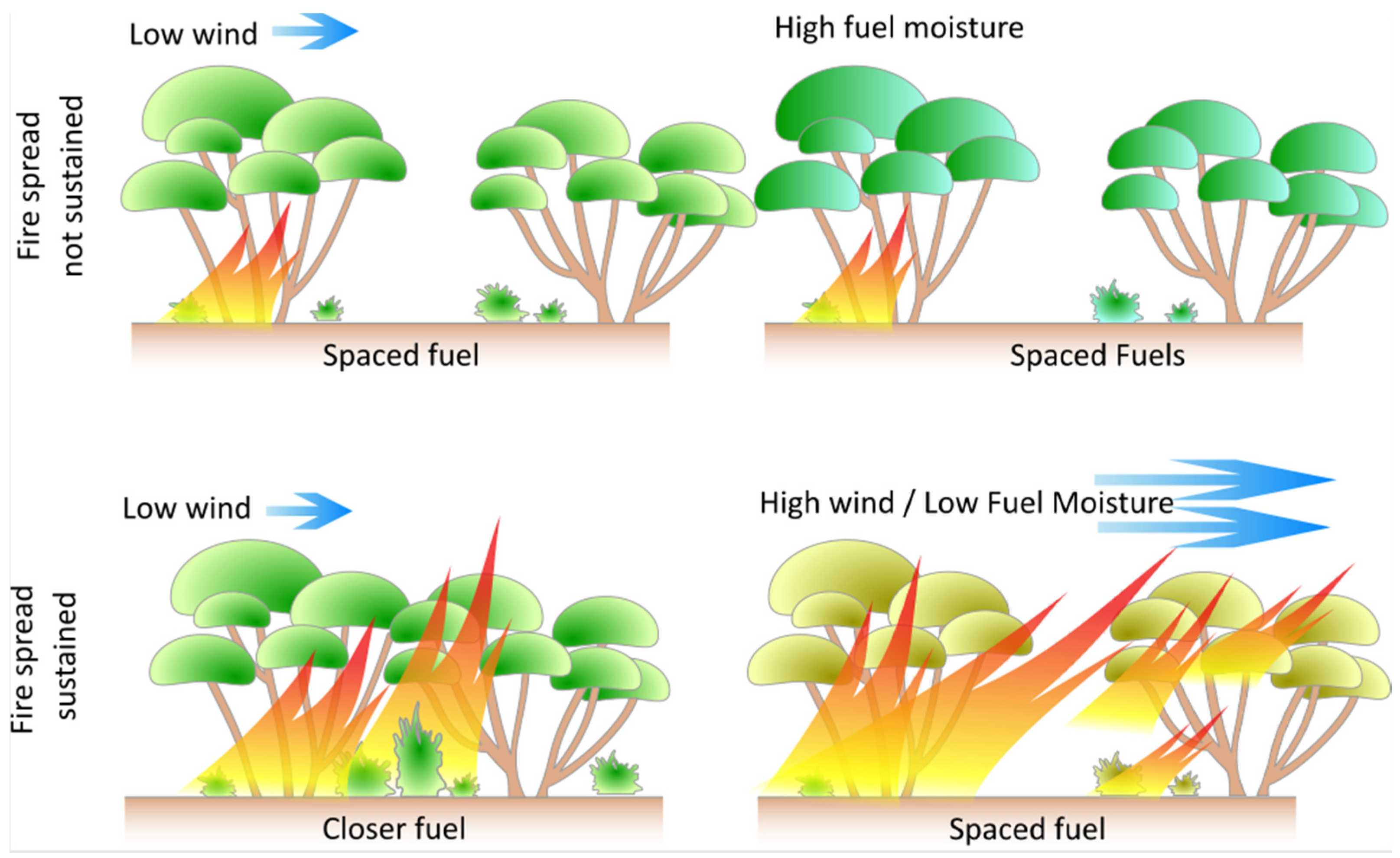
4.1. Horizontal Fuel Continuity Metrics

Arid and semi-arid shrublands have a surface and near-surface fuel discontinuity which must be overcome for sustained fire spread [6,13,30,75]. This is logically true of other fuel types including sparse (“eaten-out” and hummock) grasslands [76,77] and forest fuels [78] but is more pronounced in shrublands.
The results of the expert user workshop found that surface (or litter) and near-surface cover and continuity metrics were the most important fuel structure metrics for fire spread in shrublands. Despite this strong recommendation by experts, only one of the empirical fire models reviewed used near-surface fuel as a predictor of fire spread [13] and one notes that near-surface fuel continuity is “key to accurately predicting fire sustainability” but uses overstorey cover as a fuel parameter [12]. Near-surface fuel metrics are considered difficult to assess in situ [12]. However, considering the results of the workshops and the literature combined, future fire studies in mallee should still attempt to quantify the influence of near-surface fuel on fire behaviour.
Canopy metrics were ranked low by experts during the workshop, and this contrasts with the importance of canopy height and cover used in models such as the semi-arid mallee and generic shrubland models. Canopy cover has a negative effect on fire behaviour possibly due to the effect on wind speed in subcanopy fires and influence on litter and lower shrub fuels [12,13]. This apparent conflict of importance in canopy metrics between the workshop results and the literature can possibly be explained by the note by the authors that the canopy cover is a surrogate for other more complex fuel metrics [12,13,48].

4.2. Vertical Fuel Continuity Metrics

Previous fire modelling studies in shrublands have tended to use height estimates as the only measure of vertical fuel structures. However, vertical continuity metrics have been used for operational fire models in other fuel types to model the transition from surface fire to crown fire [79,80]. The comments from expert workshop participants and a review of the literature on similar vegetation types [12] indicate that the transition to crown fire is a critical phase in fire behaviour for shrublands. Feedback from the expert workshop indicate that gaps between fuel strata as the most important vertical fuel metric from the options provided. This aligns with Cruz et al. [79] and Cruz et al. [80], who used fuel strata gaps as an input for a crown fire threshold model, albeit in pine forests. There is an overlap of model authors and workshop participants and caution is needed when interpreting these results due to potential double counting of metrics which were considered important in both the literature and workshop results. The overlap between workshop participants and model authors was somewhat unavoidable, as the researchers who have published fire spread models for shrublands were also the most suitable to participate in the workshop. Although not presented to the workshop participants, an alternative metric is the average height of the near-surface and elevated fuel strata weighted by the percent cover of the respective layer [81].
There is no clear consensus in the literature about why this apparent conflict in anecdotal observations of fuel drivers and parameters used in shrubland fire spread models has occurred. One possibility is that continuity metrics are more difficult or time consuming to assess, and an element of pragmatism is required in fire modelling. Difficulty in consistent assessment by observers could lead to high variation and lower accuracy, which would mean that other fuel metrics are more significant in model development [74]. In studies which incorporate various data sources, the lack of consistent methods also tends to exclude some metrics from being candidates [48]. The time and cost of collection may also contribute to the selection of other fuel structure metrics in shrubland fire models.

4.3. Bulk Density Metrics

Bulk density can be calculated from height, cover, and load measurements and is a logical way of combining these three metrics into a single metric. Increasing bulk density has been found to decrease the rate of spread and is used in alternative models for several studies [41,48,55,82]; however, given the correlation to fuel load and cover, it can also increase the likelihood of sustained fire spread and crown fire. Bulk density is also the primary fuel structure variable used in the Rothermel model [23] and is usually derived from fuel loading (weight per unit area) and fuel bed height [28].
Despite this seemingly useful way of describing complex fuel structures, it was not rated as high in expert workshops. During the expert workshops, it was observed that researchers had a better understanding of the definition and role of fuel bulk density in influencing fire behaviour than practitioners. Expert practitioners (from Australia) were generally not used to using the term or conceptualising fuel structure in terms of bulk density. This may have resulted in lower scoring for bulk density metrics, considering that height, load, and cover metrics are essentially combined to make a single bulk density metric.
Physical fire models have been used to study the influence of fuel on fire spread [83,84,85]. Physical fire models continue to improve through the inclusion of additional data describing physical processes and become cheaper and faster to run [86,87,88,89]. However, field experiments and direct or indirect measurement of fuels will continue to play a key role in validation, whether for an empirical or physical model.
Recent advances in the development of remote sensing technologies and methods to derive fuel metrics show promise in providing systematic and reliable fuel information, particularly for canopy layers [90,91,92]. Terrestrial and mobile laser scanners (TLSs and MLSs) have been used to derive sub canopy fuel metrics which could be used for existing fire spread models [74,91,93,94,95,96,97,98,99,100]. TLSs and MLSs offer a significant advantage over airborne laser scanning (ALS) because they can better differentiate between elevated and near-surface features without being hindered by canopy occlusion. The research and workshop findings highlight the importance of near-surface fuel to fire sustainability, so using sub canopy LIDAR to measure near surface fuel structures warrants further investigation. The ability to derive complex fuel metrics such as vertical continuity and bulk density from these types of data means that improved ways of describing fuel structures can be incorporated into next-generation fire spread models. As demonstrated by the findings of this study, these more complex fuel metrics are considered to be a key driver of fire behaviour in coastal mallee but omitted as inputs in models due to their difficulty in being reliably measured using traditional field-based techniques.
The inclusion of traditional fuel metrics (e.g., height and cover) and novel 3D remotely sensed fuel metrics in shrubland fire experiments offers several opportunities. Measuring existing fuel metrics allows for a comparison of new fire sustainability thresholds and rate of spread data to be compared to existing fire behaviour models. Traditional field methods could be used for the validation of remotely sensed metrics and to improve the spatial explicitness of fuel mapping. Three-dimensional remote sensing can also be used to derive vegetation continuity metrics, suggested by the results of this study [97,101]. To validate the results of the expert workshops, future fire studies in shrublands need to not only compare the results to existing fire models but develop new models or parameterisation using new metrics.

5. Conclusions

Fuel height, fuel connectivity, cover, and bulk density are considered to play a role in determining coastal mallee shrubland fire behaviour. These fuel structural metrics are usually strongly correlated with each other and often the most consistent or reliable fuel metric collected is used in fire models in preference to the most significant or the metric which produces the model with the lowest error. While height is currently the most frequently used metric in shrubland fire behaviour models, the expert workshop results indicate that the cover and connectivity metrics are key to fire behaviour in coastal mallee shrublands. The measures used by most studies reported in the literature were simplistic, with the exception of those models developed for mallee systems [12,13,14], so collecting detailed height, cover, and connectivity data within the fuel complex (i.e., detailed metrics per fuel strata) may provide more insight into fire thresholds. These three metrics should continue to be collected for field sampling and experimental burning to allow comparisons with previous studies.
Few studies have considered metrics for vertical connectivity of shrubland fuels, which are considered to be an important determinant of crown fires and, therefore, result in rapid increases in the rate of fire spread and intensity. The results of expert workshops suggest that horizontal and vertical connectivity are considered to play a critical role in fire spread thresholds for shrublands, particularly in prescribed burn conditions. While these results are somewhat subjective due to the small number of participants and subjective nature of the assessment of fuel drivers of fire spread, we believe they warrant further investigation. Based on the finding of the literature review and workshop, we recommend that vertical connectivity or the measurement of gaps between fuel strata be included alongside height and cover metrics in future shrubland fire research.

Author Contributions

Conceptualization and methodology S.T., K.R., S.J. and J.H.; literature review, workshop, writing—original draft preparation, S.T.; writing—review and editing, S.T., K.R., S.J. and J.H.; visualization, S.T. and J.H.; supervision, K.R., S.J. and J.H.; funding acquisition, S.T. and K.R. All authors have read and agreed to the published version of the manuscript.

Funding

This research was funded by Natural Hazards Research Australia through provision of a scholarship.

Informed Consent Statement

Informed consent was obtained from all workshop participants involved in the study.

Data Availability Statement

Data are contained within the article.

Acknowledgments

We would like to acknowledge Natural Hazards Research Australia for providing scholarship funding. The authors sincerely thank the participants who contributed their time and expertise to the workshops—Mike Wouters, Anthony Sandeman, Aaron Macumber, Ian Tanner, Joe Tilley, Lachie McCaw, Miguel Cruz, and Paulo Fernandes. Additional thanks to Mike Wouters for reviewing the draft manuscript, and the reviewers who provided feedback on the manuscript.

Conflicts of Interest

The authors declare no conflicts of interest.

Appendix A. Coastal Mallee Fuel Driver Workshop Questions

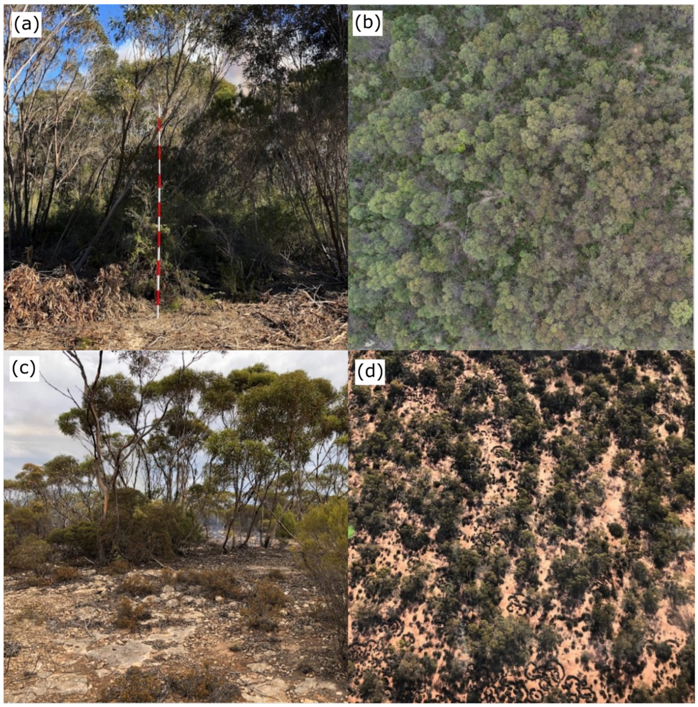
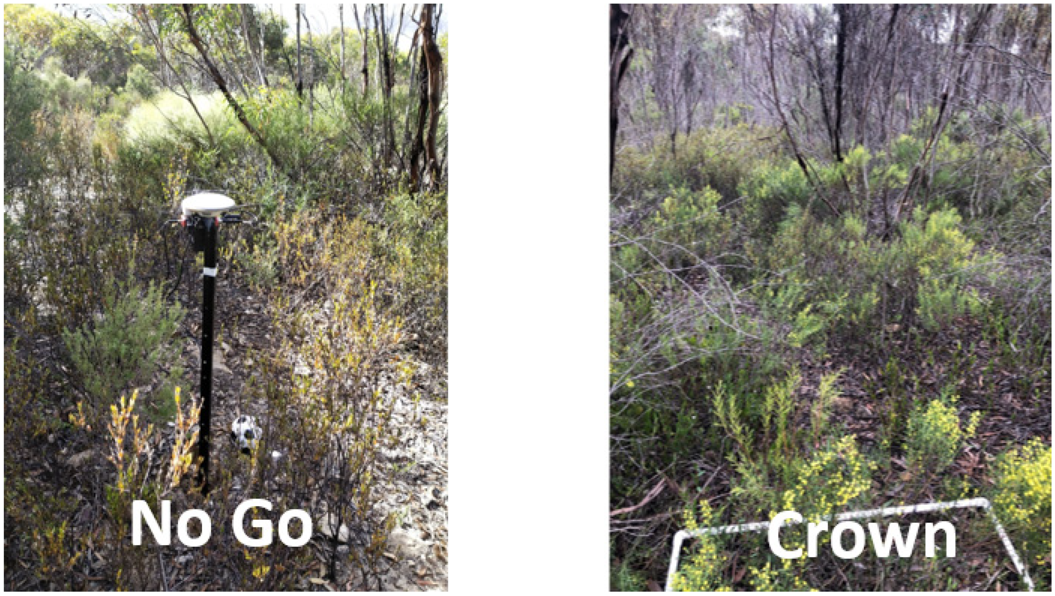
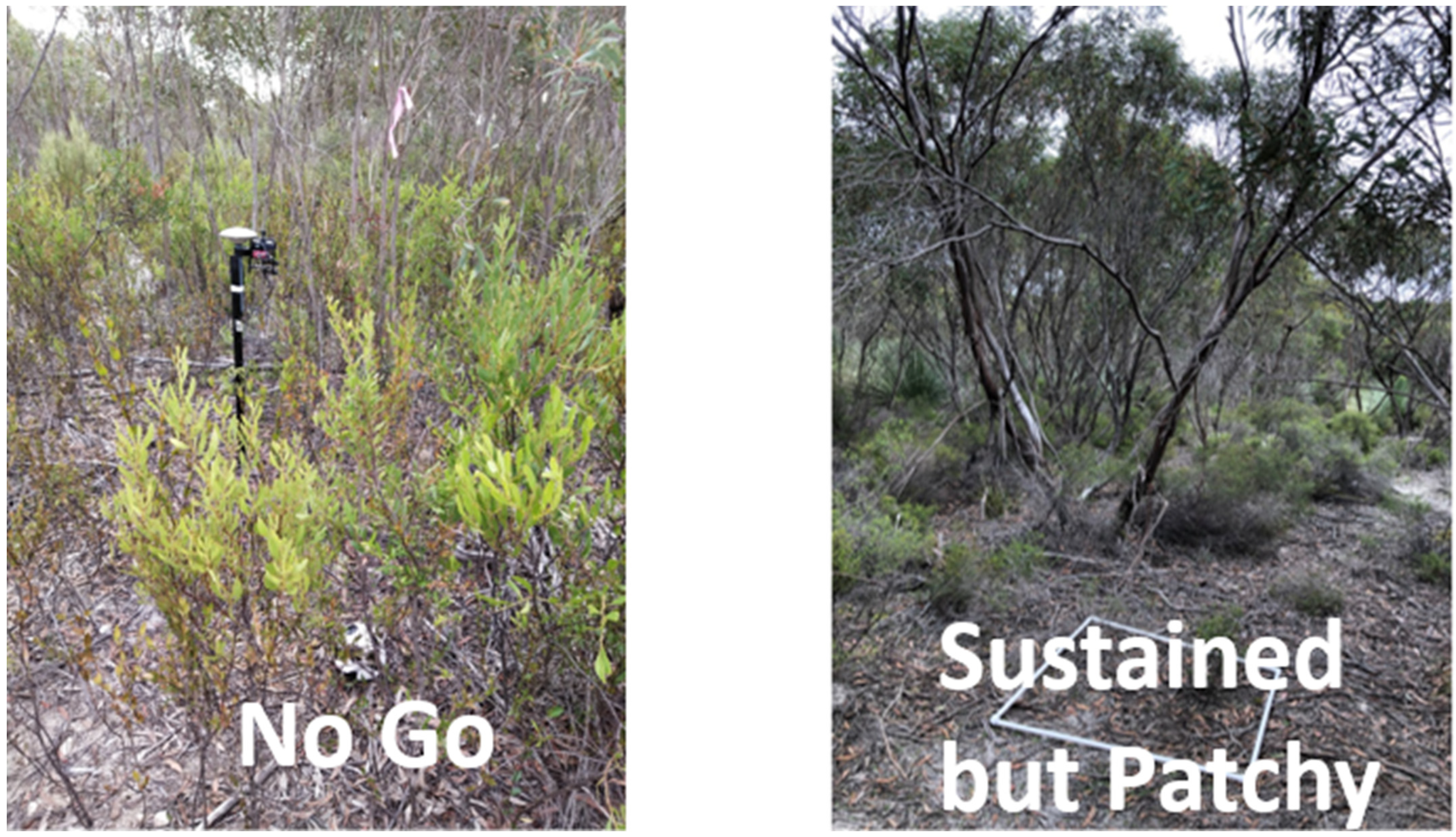
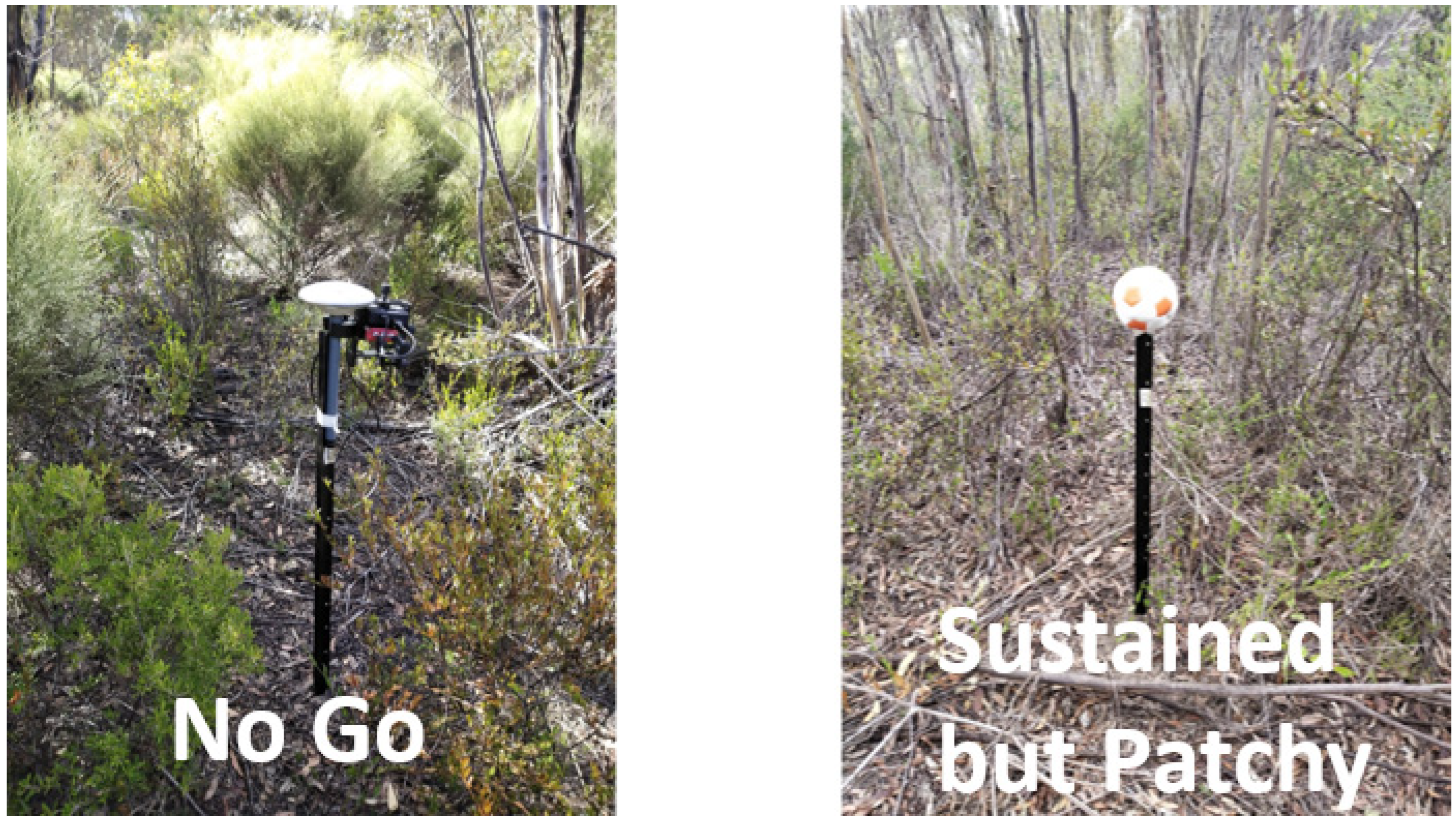
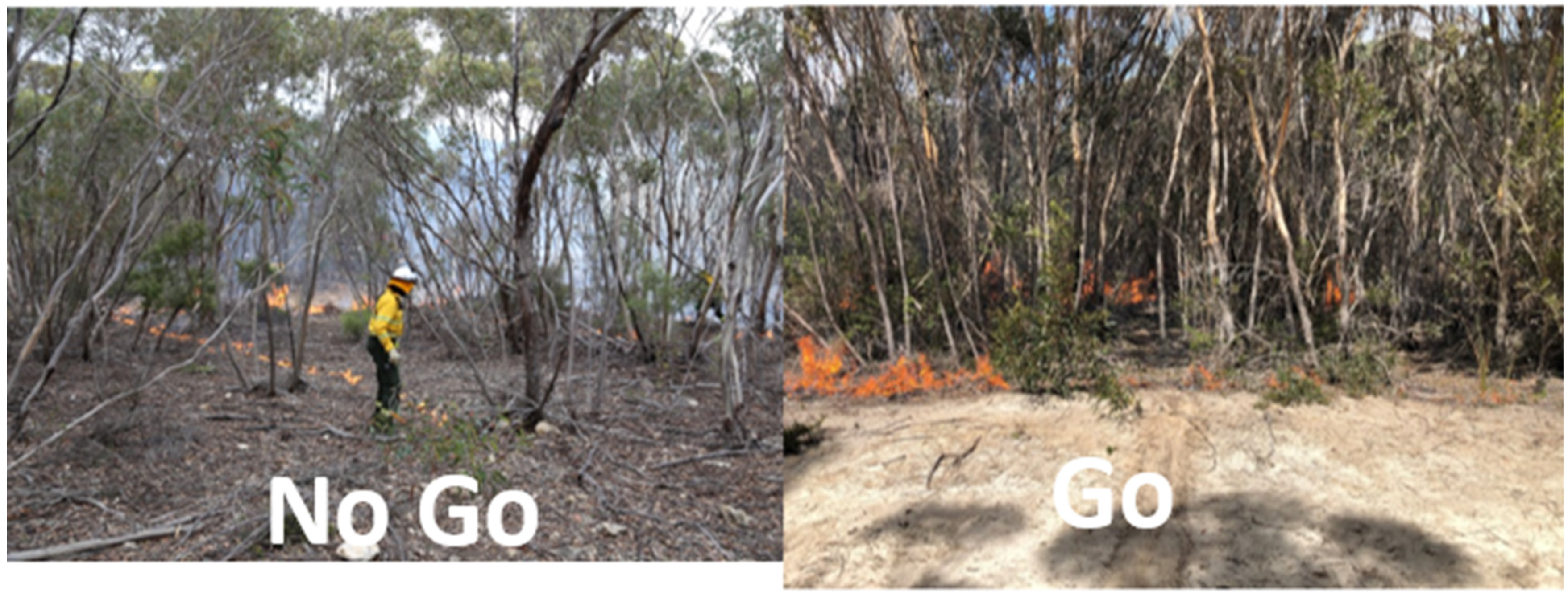
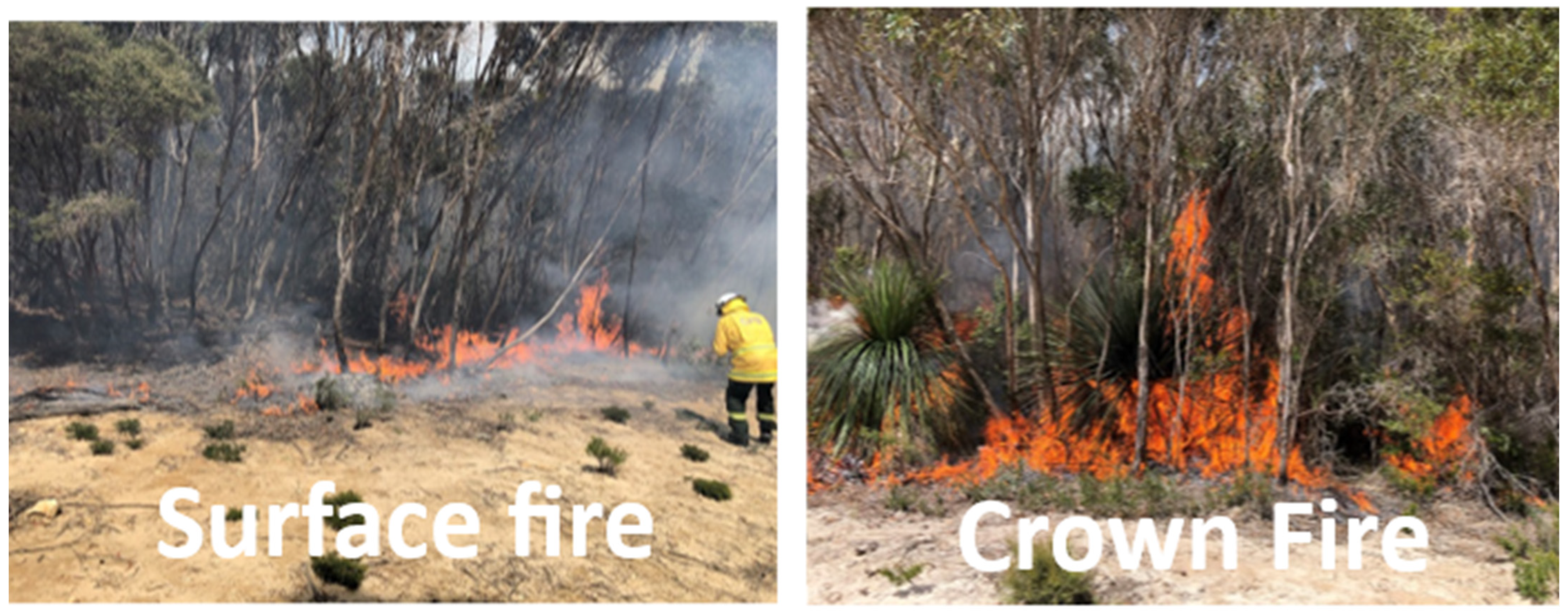
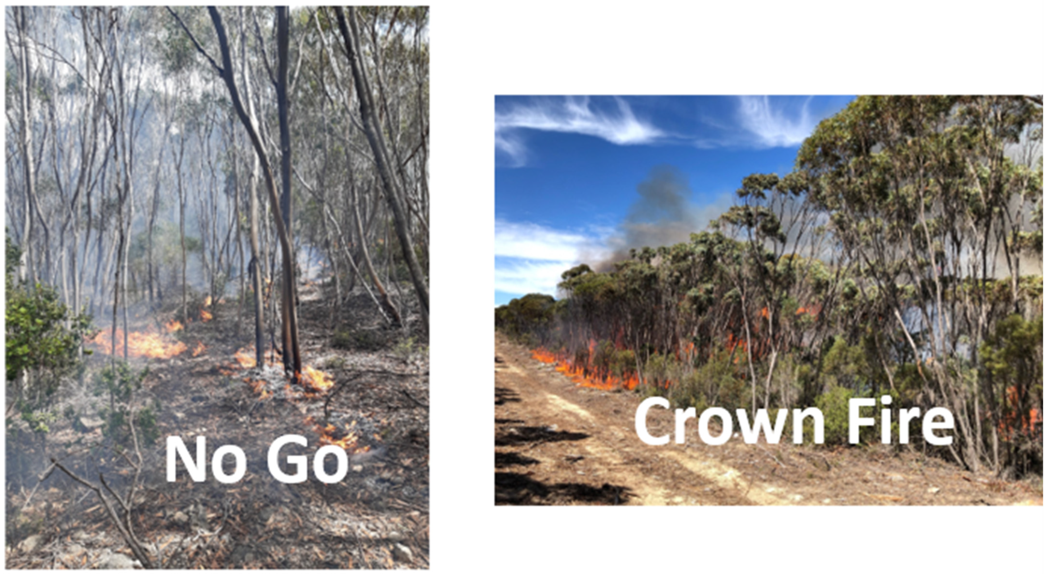
Appendix A.1. Paired Photos of Closed Mallee Shrublands—Fuel Strata

Rate the importance of each fuel strata to fire spread for each photo pair slide (Slides 1–7 in Appendix A)
  • Canopy fuel;
  • Elevated fuel;
  • Near-surface fuel;
  • Surface fuel.

Appendix A.2. Paired Photos of Closed Mallee Shrublands—Fuel Metrics

Weight the contribution of fuel metrics to fire spread for photo pairs (see Appendix B):
  • Canopy fuel height;
  • Gap between elevated and canopy;
  • Elevated fuel density;
  • Near-surface fuel height;
  • Surface fuel cover.
  • Canopy cover;
  • Elevated fuel height;
  • Near-surface fuel density;
  • Surface fuel load;
  • Whole fuel bed bulk density.
  • Canopy height;
  • Elevated fuel height;
  • Near-surface and elevated fuel load;
  • Near-surface cover;
  • Surface fuel connectivity.
  • Canopy cover;
  • Elevated to canopy gap;
  • Near-surface fuel vertical connectivity;
  • Surface fuel load;
  • Surface cover.
  • Canopy height;
  • Elevated to canopy gap;
  • Elevated fuel density;
  • Near-surface fuel load;
  • Surface fuel cover.
  • Canopy fuel;
  • Elevated to canopy gap;
  • Elevated fuel height;
  • Near-surface to elevated connectivity;
  • Surface fuel depth.
  • Canopy cover;
  • Canopy height;
  • Elevated fuel load;
  • Near-surface fuel cover;
  • Surface fuel depth.

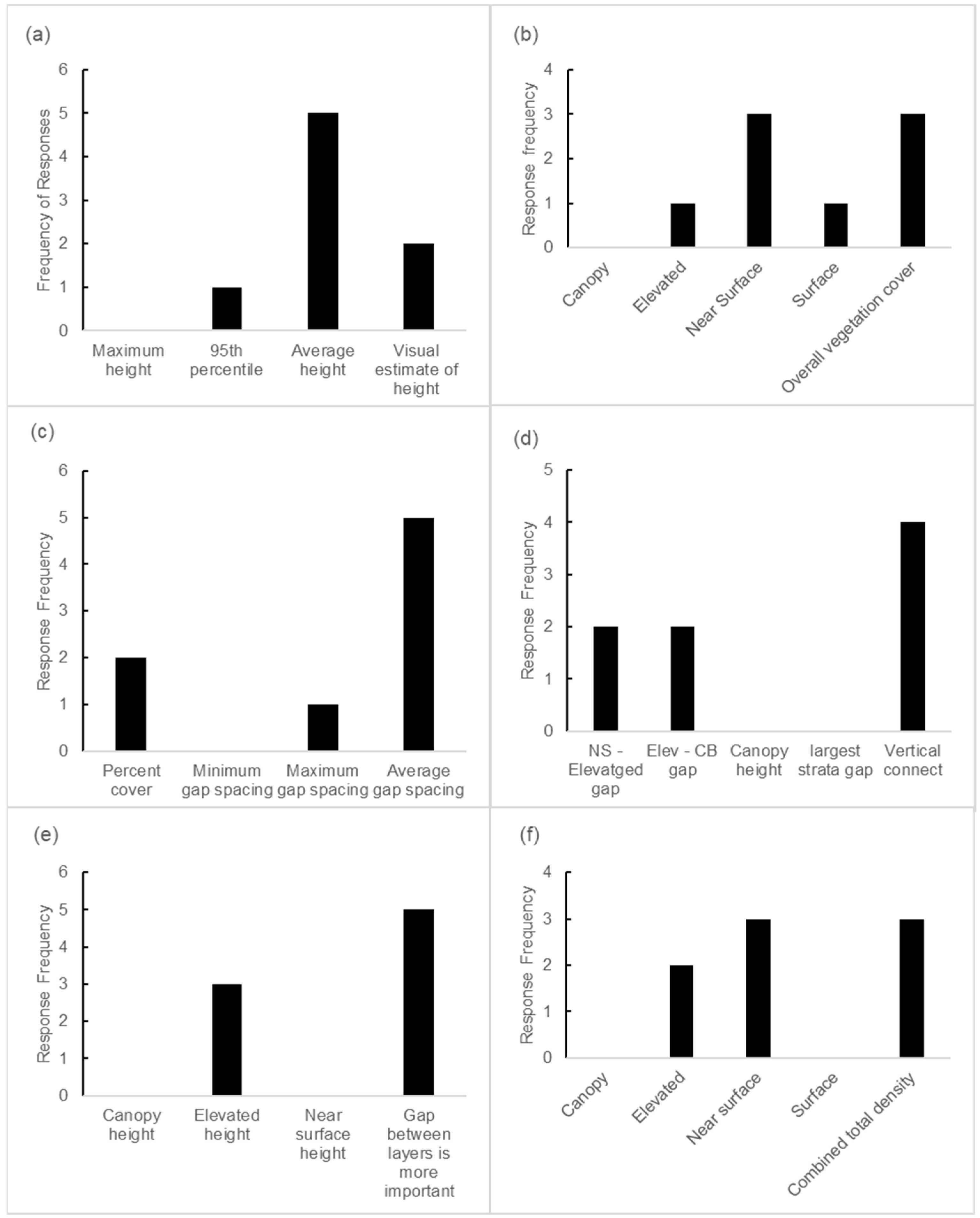
Appendix A.3. Influence of Fuel Metrics on Sustained Fire Spread in Shrublands

Which height metric (or litter depth) has the most influence on sustained fire spread in shrublands?
  • Maximum height or depth in assessment area (e.g., the top of canopy of tallest tree);
  • nth percentile height of all measurement in assessment area (e.g., 95, 90, 75th);
  • Average litter/shrub/canopy heights in assessment area;
  • Visual estimate of height or depth.
Which strata horizontal cover/continuity is most important to fire spread thresholds in shrublands?
  • Canopy;
  • Elevated;
  • Near-surface;
  • Surface;
  • Overall vegetation cover.
Which measure of horizontal cover/continuity has the most importance to fire spread thresholds in shrublands?
  • Percent cover;
  • Minimum gap spacing;
  • Maximum gap spacing;
  • Average (or a percentile) gap spacing.
Which vertical fuel metric has the most influence of fire spread (and crown fire) thresholds in shrublands?
  • Gap between near-surface and elevated fuel;
  • Gap between elevated and canopy base;
  • Canopy or elevated height;
  • Size of the largest gap between any fuel layers;
  • Vertical connectivity.
Which height metric has the most influence on fire spread and crown fire behaviour in shrublands?
  • Canopy height;
  • Elevated height;
  • Near-surface height;
  • Gap between layers is more important.
Which strata bulk density (fuel load/volume) is most important to fire spread in shrublands?
  • Canopy;
  • Elevated;
  • Near-surface;
  • Surface;
  • Combined total density.

Appendix A.4. Influence of Fuel Metrics on Sustained Fire Spread in Shrublands within a Strata

Rate the importance of the following surface fuel metrics on fire spread threshold:
  • Litter depth;
  • Litter weight (fuel load);
  • Litter density/arrangement;
  • Litter cover.
Rate the importance of the following near-surface fuel metrics on fire spread threshold:
  • Near-surface height;
  • Near-surface cover;
  • Near-surface bulk density;
  • Near-surface fuel load;
  • Vertical connectivity to elevated fuel (or gap size);
  • Live:Dead ratio.
Rate the importance of the following elevated fuel metrics on fire spread threshold:
  • Elevated fuel height;
  • Elevated fuel load;
  • Elevated fuel cover;
  • Elevated fuel density;
  • Gap between elevated and canopy base;
  • Live:Dead fine fuel ratio.
Rate the importance of the following canopy fuel metrics on fire spread threshold:
  • Canopy height;
  • Canopy base height;
  • Canopy cover;
  • Canopy bulk density;
  • Canopy load.
What is important for a fuel hazard score in coastal mallee?
  • Hazard score for assessing fuel for prescribed burn in shrublands;
  • Visual fuel hazard method important in shrublands;
  • Data derived hazard score important in shrublands;
  • Physical measures of fuel are important in fire spread thresholds.

Appendix B. Coastal Mallee Fuel Driver Workshop Photos Pair Slides Used in Appendix A.1 and Appendix A.2

Figure A1. Coastal mallee shrubland example. Both areas depicted in photographs were ignited under similar wind and fuel moisture conditions. No Go = Fire failed to sustain spread after ignition. Crown = Fire developed into a sustained crown fire.
Fire 07 00128 g0a1
Figure A2. Coastal mallee shrubland example. Both areas depicted in photographs were ignited under similar wind and fuel moisture conditions. No Go = Fire failed to sustain spread after ignition. Crown = Fire developed into a sustained crown fire.
Fire 07 00128 g0a2
Figure A3. Coastal mallee shrubland example. Both areas depicted in photographs were ignited under similar wind and fuel moisture conditions. No Go = Fire failed to sustain spread after ignition. Sustained but Patchy = Fire actively spread, but missed some areas of fuel and did not actively crown.
Fire 07 00128 g0a3
Figure A4. Coastal mallee shrubland example. Both areas depicted in photographs were ignited under similar wind and fuel moisture conditions. No Go = Fire failed to sustain spread after ignition. Sustained but Patchy = Fire actively spread, but missed some areas of fuel and did not actively crown.
Fire 07 00128 g0a4
Figure A5. Coastal mallee shrubland example. Both areas depicted in photographs were ignited under similar wind and fuel moisture conditions. No Go = Fire failed to sustain spread after ignition. Go = Fire actively spread in surface fuel, with some occasional torching, but not active crown fire.
Fire 07 00128 g0a5
Figure A6. Coastal mallee shrubland example. Both areas depicted in photographs were ignited under similar wind and fuel moisture conditions Crown Fire = Sustained active crown fire. Surface fire = Fire actively spread in surface fuel, with some occasional torching, but not active crown fire.
Fire 07 00128 g0a6
Figure A7. Coastal mallee shrubland example. Both areas depicted in photographs were ignited under similar wind and fuel moisture conditions Crown Fire = Sustained active crown fire. No Go = Fire failed to sustain spread after ignition.
Fire 07 00128 g0a7

References

  1. Filkov, A.I.; Ngo, T.; Matthews, S.; Telfer, S.; Penman, T.D. Impact of Australia’s catastrophic 2019/20 bushfire season on communities and environment. Retrospective analysis and current trends. J. Saf. Sci. Resil. 2020, 1, 44–56. [Google Scholar] [CrossRef]
  2. Peace, M.; Mills, G. A Case Study of the 2007 Kangaroo Island Bushfires; Centre for Australian Weather and Climate Research: Melbourne, Australia, 2012. [Google Scholar]
  3. Clarke, H.; Cirulis, B.; Price, O.; Bradstock, R.; Boer, M.; Rawlins, A.; Penman, T. Risk Mitigation from Prescribed Burning in Kangaroo Island and Mount Lofty Ranges; Bushfire and Natural Hazards CRC: Melbourne, Australia, 2021. [Google Scholar]
  4. DoEE. MVG 14–Mallee Woodlands and Shrublands; Australian Government, Department of the Environment and Energy: Canberra, Australia, 2017.
  5. Nicolle, D. Native Eucalypts of South Australia; Dean Nicolle: Adelaide, SA, USA, 2013. [Google Scholar]
  6. Bradstock, R.A.; Gill, A.M. Fire in Semiarid, Mallee Shrublands—Size of Flames From Discrete Fuel Arrays and Their Role in the Spread of Fire. Int. J. Wildland Fire 1993, 3, 3–12. [Google Scholar] [CrossRef]
  7. Ball, D. Kangaroo Island Vegetation Mapping; Department for Transport, Urban Planning and the Arts: Adelaide, Australia, 1998.
  8. Brandle, R. A Biological Survey of the Eyre Peninsula, South Australia; Department for Environment and Heritage, Government of South Australia: Adelaide, Australia, 2010.
  9. CANBR. EUCLID—Eucalypts of Australia Fourth Edition; Centre for Australian National Biodiversity Research, Australian National Herbarium & CSIRO National Research Collections Australia: Canberra, Australia, 2020.
  10. Berkinshaw, T. Native Vegetatin of the Eyre Pensisula, South Australia; Finsbury Green Printers: Adelaide, Australia, 2010; p. 234. [Google Scholar]
  11. Robinson, A.C.; Armstrong, D.M. A Biological Survey of Kangaroo Island, 1989 & 1990; Department for Environment, Heritage and Aboriginal Affairs, Government of South Australia: Adelaide, Australia, 1999.
  12. Cruz, M.G.; McCaw, W.L.; Anderson, W.R.; Gould, J.S. Fire behaviour modelling in semi-arid mallee-heath shrublands of southern Australia. Environ. Model. Softw. 2013, 40, 21–34. [Google Scholar] [CrossRef]
  13. Cruz, M.; Matthews, S.; Gould, J.; Ellis, P.; Henderson, M.; Knight, I.; Watters, J. Fire Dynamics in Mallee-Heath. In Fuel, Weather and Fire Behaviour Prediction in South Australian Semi-Arid Shrublands; CSIRO Sustainable Ecosystems: Canberra, Australia, 2010. [Google Scholar]
  14. McCaw, W.L. Predicting Fire Spread in Western Australian Mallee-Heath Scrubland. Ph.D. Thesis, University of New South Wales, Canberra, Australia, 1997. [Google Scholar]
  15. Moreira, F.; Ascoli, D.; Safford, H.; Adams, M.A.; Moreno, J.M.; Pereira, J.M.C.; Catry, F.X.; Armesto, J.; Bond, W.; González, M.E.; et al. Wildfire management in Mediterranean-type regions: Paradigm change needed. Environ. Res. Lett. 2020, 15, 011001. [Google Scholar] [CrossRef]
  16. Snyder, H. Literature review as a research methodology: An overview and guidelines. J. Bus. Res. 2019, 104, 333–339. [Google Scholar] [CrossRef]
  17. Sullivan, A.L. Wildland surface fire spread modelling, 19902007. 1: Physical and quasi-physical models. Int. J. Wildland Fire 2009, 18, 349–368. [Google Scholar] [CrossRef]
  18. Sullivan, A.L. Wildland surface fire spread modelling, 19902007. 2: Empirical and quasi-empirical models. Int. J. Wildland Fire 2009, 18, 369–386. [Google Scholar] [CrossRef]
  19. Moinuddin, K.A.M.; Sutherland, D. Modelling of tree fires and fires transitioning from the forest floor to the canopy with a physics-based model. Math. Comput. Simul. 2020, 175, 81–95. [Google Scholar] [CrossRef]
  20. Ahmed, M.M. Simulations of flaming combustion and flaming-to-smoldering transition in wildland fire spread at flame scale. Combust. Flame 2024, 262, 113370. [Google Scholar] [CrossRef]
  21. Simeoni, A.; Salinesi, P.; Morandini, F. Physical modelling of forest fire spreading through heterogeneous fuel beds. Int. J. Wildland Fire 2011, 20, 625–632. [Google Scholar] [CrossRef]
  22. Alexander, M.E.; Cruz, M.G. Are the applications of wildland fire behaviour models getting ahead of their evaluation again? Environ. Model. Softw. 2013, 41, 65–71. [Google Scholar] [CrossRef]
  23. Rothermel, R.C. A Mathematical Model for Predicting Fire Spread in Wildland Fuels; Intermountain Forest and Range Experiment Station, Forest Service, U.S. Department of Agriculture: Ogeden, UT, USA, 1972; Volume 115.
  24. Burgan, R.E.; Rothermel, R.C. BEHAVE: Fire Behavior Prediction and Fuel Modeling System–FUEL Subsystem; US Department of Agriculture, Forest Service, Rocky Mountain Research Station: Fort Collins, CO, USA, 1984.
  25. Andrews, P.L. Current status and future needs of the BehavePlus Fire Modeling System. Int. J. Wildland Fire 2014, 23, 21–33. [Google Scholar] [CrossRef]
  26. Finney, M.A. An overview of FlamMap fire modeling capabilities. In Proceedings of the Fuels Management-How to Measure Success: Conference Proceedings, Portland, OR, USA, 28–30 March 2006; Proceedings RMRS-P-41. Andrews, P.L., Butler, B.W., Eds.; US Department of Agriculture, Forest Service, Rocky Mountain Research Station: Fort Collins, CO, USA, 2006; pp. 213–220. [Google Scholar]
  27. Finney, M.A. FARSITE, Fire Area Simulator–Model Development and Evaluation; US Department of Agriculture, Forest Service, Rocky Mountain Research Station: Fort Collins, CO, USA, 1998.
  28. Andrews, P.L. The Rothermel Surface Fire Spread Model and Associated Developments: A Comprehensive Explanation; US Department of Agriculture, Forest Service, Rocky Mountain Research Station: Fort Collins, CO, USA, 2018; p. 121.
  29. Scott, J.H.; Burgan, R.E. Standard Fire Behavior Fuel Models: A Comprehensive Set for Use with Rothermel’s Surface Fire Spread Model; General Technical Report RMRS-GTR-153; US Department of Agriculture, Forest Service, Rocky Mountain Research Station: Fort Collins, CO, USA, 2005.
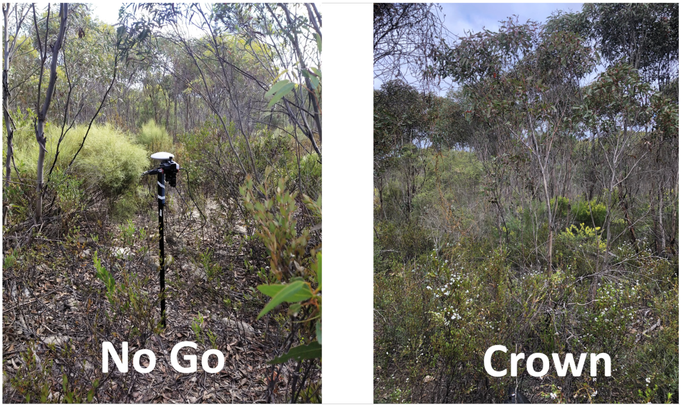
  30. Weise, D.R.; Zhou, X.; Sun, L.; Mahalingam, S. Fire spread in chaparralgo or no-go? Int. J. Wildland Fire 2005, 14, 99–106. [Google Scholar] [CrossRef]
  31. Conard, S.G.; Regelbrugge, J.C. On Estimating fuel characteristics in California Chaparral. In Proceedings of the 12th Conference on Fire and Forest Meteorology, Jekyll Island, GA, USA, 26–28 October 1993; pp. 120–129. [Google Scholar]
  32. Dimitrakopoulos, A.P. Mediterranean fuel models and potential fire behaviour in Greece. Int. J. Wildland Fire 2002, 11, 127–130. [Google Scholar] [CrossRef]
  33. Arca, B.; Duce, P.; Laconi, M.; Pellizzaro, G.; Salis, M.; Spano, D. Evaluation of FARSITE simulator in Mediterranean maquis. Int. J. Wildland Fire 2007, 16, 563. [Google Scholar] [CrossRef]
  34. Elia, M.; Lafortezza, R.; Lovreglio, R.; Sanesi, G. Developing Custom Fire Behavior Fuel Models for Mediterranean Wildland–Urban Interfaces in Southern Italy. Environ. Manag. 2015, 56, 754–764. [Google Scholar] [CrossRef] [PubMed]
  35. Malanson, G.P.; Trabaud, L. Computer simulations of fire behaviour in garrigue in southern France. Appl. Geogr. 1988, 8, 53–64. [Google Scholar] [CrossRef]
  36. Van Wilgen, B.W.; Maitre, D.C.L.; Kruger, F.J. Fire Behaviour in South African Fynbos (Macchia) Vegetation and Predictions from Rothermel’s Fire Model. J. Appl. Ecol. 1985, 22, 207. [Google Scholar] [CrossRef]
  37. Streeks, T.J.; Owens, M.K.; Whisenant, S.G. Examining fire behavior in mesquiteacacia shrublands. Int. J. Wildland Fire 2005, 14, 131–140. [Google Scholar] [CrossRef]
  38. Xanthopoulos, G.; Manasi, M. A Practical Methodology for the Development of Shrub Fuel Models for Fire Behavior Prediction; Millpress: Rotterdam, The Netherlands, 2002. [Google Scholar]
  39. Bilgili, E.; Saglam, B. Fire behavior in maquis fuels in Turkey. For. Ecol. Manag. 2003, 184, 201–207. [Google Scholar] [CrossRef]
  40. Fernandes, P.M. Fire spread prediction in shrub fuels in Portugal. For. Ecol. Manag. 2001, 144, 67–74. [Google Scholar] [CrossRef]
  41. Fernandes, P.M.; Catchpole, W.R.; Rego, F.C. Shrubland fire behaviour modelling with microplot data. Can. J. For. Res. 2000, 30, 889–899. [Google Scholar] [CrossRef]
  42. Saǧlam, B.; Bilgili, E.; Küçük, Ö.; Durmaz, B.D. Fire behavior in Mediterranean shrub species (Maquis). Afr. J. Biotechnol. 2008, 7, 4122–4129. [Google Scholar]
  43. Vega, J.A.; Cuinas, P.; Fonturbel, T.; Perez-Gorostiaga, P.; Fernandez, C. Predicting fire behaviour in Galician (NW Spain) shrubland fuel complexes. In Proceedings of the Third International Conference on Forest Fire Research/14th Fire and Forest Meteorology Conference, Luso, Portugal, 16–20 November 1998; pp. 713–728. [Google Scholar]
  44. Baeza, M.J.; De Luís, M.; Raventós, J.; Escarré, A. Factors influencing fire behaviour in shrublands of different stand ages and the implications for using prescribed burning to reduce wildfire risk. J. Environ. Manag. 2002, 65, 199–208. [Google Scholar] [CrossRef] [PubMed]
  45. Castillo, S.M.; Plaza, V.Á.; Garfias, S.R. A recent review of fire behavior and fire effects on native vegetation in Central Chile. Glob. Ecol. Conserv. 2020, 24, e01210. [Google Scholar] [CrossRef]
  46. Julio, G.; Pedernera, P.; Aguilera, R. Aplicaciones del SIG en la Gestión de la Protección contra los Incendios Forestales-El Sistema KITRAL. In Santiago, Chile: Actas Taller Regional FAO Aplicaciones de la Teledetección y los Sistemas de Información Geográfica a la Gestión Agrícola y del Medio Ambiente; FAO Chile: Santiago, Chile, 1998. [Google Scholar]
  47. Marsden-Smedley, J.B.; Catchpole, W.R. Fire Behaviour Modelling in Tasmanian Buttongrass Moorlands. II. Fire Behaviour. Int. J. Wildland Fire 1995, 5, 215–228. [Google Scholar] [CrossRef]
  48. Anderson, W.R.; Cruz, M.G.; Fernandes, P.M.; McCaw, L.; Vega, J.A.; Bradstock, R.A.; Fogarty, L.; Gould, J.; McCarthy, G.; Marsden-Smedley, J.B.; et al. A generic, empirical-based model for predicting rate of fire spread in shrublands. Int. J. Wildland Fire 2015, 24, 443–460. [Google Scholar] [CrossRef]
  49. Catchpole, W.R.; Bradstock, R.; Choate, J.; Fogarty, L.; Gellie, N.; McCarthy, G.; McCaw, L.; Marsden-Smedley, J.; Pearce, H. Cooperative development of equations for heathland fire behaviour. In Proceedings of the 3rd International Conference on Forest Fire Research and 14th Fire and Forest Meteorology Conference, Luso, Portugal, 16–20 November 1998; pp. 631–645. [Google Scholar]
  50. Marsden-Smedley, J.B. Prescribed Burning in South Australia: Operational Prescriptions; Department of Environment and Natural Resources, Government of South Australia: Adelaide, Australia, 2011.
  51. Anderson, S.A.J.; Anderson, W.R. Ignition and fire spread thresholds in gorse (Ulex europaeus). Int. J. Wildland Fire 2010, 19, 589–598. [Google Scholar] [CrossRef]
  52. Cruz, M.G.; Alexander, M.E.; Fernandes, P.M. Evidence for lack of a fuel effect on forest and shrubland fire rates of spread under elevated fire danger conditions: Implications for modelling and management. Int. J. Wildland Fire 2022, 31, 471–479. [Google Scholar] [CrossRef]
  53. DENR. Overall Fuel Hazard Guide for South Australia Second Edition; Department of Environment and Natural Resources, Government of South Australia: Adelaide, Australia, 2012.
  54. Marsden-Smedley, J.B.; Catchpole, W.R. Fire Behaviour Modelling in Tasmanian Buttongrass Moorlands. I. Fuel Characteristics. Int. J. Wildland Fire 1995, 5, 203–214. [Google Scholar] [CrossRef]
  55. Pepin, A.-C.; Wotton, M. Fire Behaviour Observation in Shrublands in Nova Scotia, Canada and Assessment of Aids to Operational Fire Behaviour Prediction. Fire 2020, 3, 34. [Google Scholar] [CrossRef]
  56. Davies, G.M.; Legg, C.J.; Smith, A.A.; Macdonald, A.J. Rate of spread of fires in Calluna vulgaris-dominated moorlands. J. Appl. Ecol. 2009, 46, 1054–1063. [Google Scholar] [CrossRef]
  57. Marino, E.; Hernando, C.; Madrigal, J.; Dez, C.; Guijarro, M. Fuel management effectiveness in a mixed heathland: A comparison of the effect of different treatment types on fire initiation risk. Int. J. Wildland Fire 2012, 21, 969–979. [Google Scholar] [CrossRef]
  58. Fontaine, J.B.; Westcott, V.C.; Enright, N.J.; Lade, J.C.; Miller, B.P. Fire behaviour in south-western Australian shrublands: Evaluating the influence of fuel age and fire weather. Int. J. Wildland Fire 2012, 21, 385–395. [Google Scholar] [CrossRef]
  59. Saǧlam, B.; Küçük, Ö.; Bilgili, E.; Durmaz, B.D.; Baysal, I. Estimating fuel biomass of some Shrub species (maquis) in Turkey. Turk. J. Agric. For. 2008, 32, 349–356. [Google Scholar]
  60. Wright, C.S.; Prichard, S.J. Biomass Consumption during Prescribed Fires in Big Sagebrush Ecosystems; US Department of Agriculture, Forest Service, Rocky Mountain Research Station: Fort Collins, CO, USA, 2006; pp. 489–500.
  61. Baeza, M.J.; Raventós, J.; Escarré, A.; Vallejo, V.R. Fire risk and vegetation structural dynamics in Mediterranean shrubland. Plant Ecol. 2006, 187, 189–201. [Google Scholar] [CrossRef]
  62. Arca, B.; Laconi, M.; Maccioni, A.; Pellizzaro, G.; Salis, M. Validation of farsite model in mediterranean area. In Proceedings of the Joint Meeting of the Sixth Symposium on Fire and Forest Meteorology and the 19th Interior West Fire Council Meeting, Canmore, AB, Canada, 25–27 October 2005; pp. 329–332. [Google Scholar]
  63. De Luis, M.; Baeza, M.J.; Raventós, J.; González-Hidalgo, J.C. Fuel characteristics and fire behaviour in mature Mediterranean gorse shrublands. Int. J. Wildland Fire 2004, 13, 79–87. [Google Scholar] [CrossRef]
  64. Dimitrakopoulos, A.P.; Dritsa, S. Novel nomographs for fire behaviour prediction in Mediterranean and submediterranean vegetation types. Forestry 2003, 76, 479–490. [Google Scholar] [CrossRef]
  65. Papió, C.; Trabaud, L. Comparative study of the aerial structure of five shrubs of mediterranean shrublands. For. Sci. 1991, 37, 146–159. [Google Scholar]
  66. Papió, C.; Trabaud, L. Structural characteristics of fuel components of five Meditarranean shrubs. For. Ecol. Manag. 1990, 35, 249–259. [Google Scholar] [CrossRef]
  67. Brown, J.K. Fuel and Fire Behavior Prediction in Big Sagebrush; US Department of Agriculture, Forest Service, Intermountain Forest and Range: Ogden, UT, USA, 1982; Volume 290.
  68. Vega, J.A.; Arellano-Pérez, S.; Álvarez-González, J.G.; Fernández, C.; Jiménez, E.; Fernández-Alonso, J.M.; Vega-Nieva, D.J.; Briones-Herrera, C.; Alonso-Rego, C.; Fontúrbel, T.; et al. Modelling aboveground biomass and fuel load components at stand level in shrub communities in NW Spain. For. Ecol. Manag. 2022, 505, 119926. [Google Scholar] [CrossRef]
  69. Marino, E.; Guijarro, M.; Madrigal, J.; Hernando, C.; Diez, C. Assessing fire propagation empirical models in shrub fuel complexes using wind tunnel data. WIT Trans. Ecol. Environ. 2008, 119, 121–130. [Google Scholar] [CrossRef]
  70. Valencia, A.; Melnik, K.O.; Sanders, N.; Sew Hoy, A.; Yan, M.; Katurji, M.; Zhang, J.; Schumacher, B.; Hartley, R.; Aguilar-Arguello, S.; et al. Influence of fuel structure on gorse fire behaviour. Int. J. Wildland Fire 2023, 32, 927–941. [Google Scholar] [CrossRef]
  71. Stephens, S.L.; Weise, D.R.; Fry, D.L.; Keiffer, R.J.; Dawson, J.; Koo, E.; Potts, J.; Pagni, P.J. Measuring the Rate of Spread of Chaparral Prescribed fires in Northern California. Fire Ecol. 2008, 4, 74–86. [Google Scholar] [CrossRef]
  72. Burrows, N.; Ward, B.; Robinson, A. Fire behaviour in spinifex fuels on the Gibson Desert Nature Reserve, Western Australia. J. Arid Environ. 1991, 20, 189–204. [Google Scholar] [CrossRef]
  73. Pickering, B.J.; Bennett, L.T.; Cawson, J.G. Extending methods for assessing fuel hazard in temperate Australia to enhance data quality and consistency. Int. J. Wildland Fire 2023, 32, 1422–1437. [Google Scholar] [CrossRef]
  74. Spits, C.; Wallace, L.; Reinke, K. Investigating Surface and Near-Surface Bushfire Fuel Attributes: A Comparison between Visual Assessments and Image-Based Point Clouds. Sensors 2017, 17, 910. [Google Scholar] [CrossRef]
  75. Cruz, M.G.; Gould, J.S.; Alexander, M.E.; Sullivan, A.L.; McCaw, W.L.; Matthews, S. Empirical-based models for predicting head-fire rate of spread in Australian fuel types. Aust. For. 2015, 78, 118–158. [Google Scholar] [CrossRef]
  76. Burrows, N.; Gill, M.; Sharples, J. Development and validation of a model for predicting fire behaviour in spinifex grasslands of arid Australia. Int. J. Wildland Fire 2018, 27, 271–279. [Google Scholar] [CrossRef]
  77. Cheney, N.P.; Gould, J.S.; Catchpole, W.R. Prediction of Fire Spread in Grasslands. Int. J. Wildland Fire 1998, 8, 1–13. [Google Scholar] [CrossRef]
  78. Gould, J.S.; Lachlan McCaw, W.; Phillip Cheney, N. Quantifying fine fuel dynamics and structure in dry eucalypt forest (Eucalyptus marginata) in Western Australia for fire management. For. Ecol. Manag. 2011, 262, 531–546. [Google Scholar] [CrossRef]
  79. Cruz, M.G.; Alexander, M.E.; Wakimoto, R.H. Modeling the Likelihood of Crown Fire Occurrence in Conifer Forest Stands. For. Sci. 2004, 50, 640–658. [Google Scholar]
  80. Cruz, M.G.; Alexander, M.E.; Fernandes, P.A.M. Development of a model system to predict wildfire behaviour in pine plantations. Aust. For. 2008, 71, 113–121. [Google Scholar] [CrossRef]
  81. Cruz, M.G.; Cheney, N.P.; Gould, J.S.; McCaw, W.L.; Kilinc, M.; Sullivan, A.L. An empirical-based model for predicting the forward spread rate of wildfires in eucalypt forests. Int. J. Wildland Fire 2022, 31, 81–95. [Google Scholar] [CrossRef]
  82. Weise, D.R.; Koo, E.; Zhou, X.; Mahalingam, S.; Morandini, F.; Balbi, J.H. Fire spread in chaparral—A comparison of laboratory data and model predictions in burning live fuels. Int. J. Wildland Fire 2016, 25, 980–994. [Google Scholar] [CrossRef]
  83. Frangieh, N.; Accary, G.; Morvan, D.; Méradji, S.; Bessonov, O. Wildfires front dynamics: 3D structures and intensity at small and large scales. Combust. Flame 2020, 211, 54–67. [Google Scholar] [CrossRef]
  84. Mell, W.; Jenkins, M.A.; Gould, J.; Cheney, P. A physics-based approach to modelling grassland fires. Int. J. Wildland Fire 2007, 16, 1–22. [Google Scholar] [CrossRef]
  85. Ziegler, J.P.; Hoffman, C.M.; Collins, B.M.; Long, J.W.; Dagley, C.M.; Mell, W. Simulated Fire Behavior and Fine-Scale Forest Structure Following Conifer Removal in Aspen-Conifer Forests in the Lake Tahoe Basin, USA. Fire 2020, 3, 51. [Google Scholar] [CrossRef]
  86. Mell, W.; Maranghides, A.; McDermott, R.; Manzello, S.L. Numerical simulation and experiments of burning douglas fir trees. Combust. Flame 2009, 156, 2023–2041. [Google Scholar] [CrossRef]
  87. Atchley, A.L.; Linn, R.; Jonko, A.; Hoffman, C.; Hyman, J.D.; Pimont, F.; Sieg, C.; Middleton, R.S. Effects of fuel spatial distribution on wildland fire behaviour. Int. J. Wildland Fire 2021, 30, 179–189. [Google Scholar] [CrossRef]
  88. Coen, J.L.; Cameron, M.; Michalakes, J.; Patton, E.G.; Riggan, P.J.; Yedinak, K.M. WRF-Fire: Coupled Weather–Wildland Fire Modeling with the Weather Research and Forecasting Model. J. Appl. Meteorol. Climatol. 2013, 52, 16–38. [Google Scholar] [CrossRef]
  89. Peace, M.; Ye, H.; Greenslade, J.; Kepert, J.D. The Destructive Sir Ivan Fire in New South Wales, Australia; Simulations Using a Coupled Fire—Atmosphere Model. Fire 2023, 6, 438. [Google Scholar] [CrossRef]
  90. Taneja, R.; Hilton, J.; Wallace, L.; Reinke, K.; Jones, S. Effect of fuel spatial resolution on predictive wildfire models. Int. J. Wildland Fire 2021, 30, 776. [Google Scholar] [CrossRef]
  91. Hillman, S.; Wallace, L.; Reinke, K.; Jones, S. A comparison between TLS and UAS LiDAR to represent eucalypt crown fuel characteristics. ISPRS J. Photogramm. Remote Sens. 2021, 181, 295–307. [Google Scholar] [CrossRef]
  92. Erdody, T.L.; Moskal, L.M. Fusion of LiDAR and imagery for estimating forest canopy fuels. Remote Sens. Environ. 2010, 114, 725–737. [Google Scholar] [CrossRef]
  93. Levick, S.R.; Whiteside, T.; Loewensteiner, D.A.; Rudge, M.; Bartolo, R. Leveraging TLS as a Calibration and Validation Tool for MLS and ULS Mapping of Savanna Structure and Biomass at Landscape-Scales. Remote Sens. 2021, 13, 257. [Google Scholar] [CrossRef]
  94. Hillman, S.; Wallace, L.; Lucieer, A.; Reinke, K.; Turner, D.; Jones, S. A comparison of terrestrial and UAS sensors for measuring fuel hazard in a dry sclerophyll forest. Int. J. Appl. Earth Obs. Geoinf. 2021, 95, 102261. [Google Scholar] [CrossRef]
  95. Wallace, L.; Hally, B.; Hillman, S.; Jones, S.D.; Reinke, K. Terrestrial Image-Based Point Clouds for Mapping Near-Ground Vegetation Structure: Potential and Limitations. Fire 2020, 3, 59. [Google Scholar] [CrossRef]
  96. Rowell, E.; Loudermilk, E.L.; Hawley, C.; Pokswinski, S.; Seielstad, C.; Queen, L.; O’Brien, J.J.; Hudak, A.T.; Goodrick, S.; Hiers, J.K. Coupling terrestrial laser scanning with 3D fuel biomass sampling for advancing wildland fuels characterization. For. Ecol. Manag. 2020, 462, 117945. [Google Scholar] [CrossRef]
  97. Alonso-Rego, C.; Arellano-Pérez, S.; Cabo, C.; Ordoñez, C.; Álvarez-González, J.G.; Díaz-Varela, R.A.; Ruiz-González, A.D. Estimating Fuel Loads and Structural Characteristics of Shrub Communities by Using Terrestrial Laser Scanning. Remote Sens. 2020, 12, 3704. [Google Scholar] [CrossRef]
  98. Hillman, S.; Wallace, L.; Reinke, K.; Hally, B.; Jones, S.; Saldias, D.S. A Method for Validating the Structural Completeness of Understory Vegetation Models Captured with 3D Remote Sensing. Remote Sens. 2019, 11, 2118. [Google Scholar] [CrossRef]
  99. Rowell, E.; Loudermilk, E.L.; Seielstad, C.; O’Brien, J.J. Using Simulated 3D Surface Fuelbeds and Terrestrial Laser Scan Data to Develop Inputs to Fire Behavior Models. Can. J. Remote Sens. 2016, 42, 443–459. [Google Scholar] [CrossRef]
  100. Chen, Y.; Zhu, X.; Yebra, M.; Harris, S.; Tapper, N. Strata-based forest fuel classification for wild fire hazard assessment using terrestrial LiDAR. J. Appl. Remote Sens. 2016, 10, 046025. [Google Scholar] [CrossRef]
  101. Hancock, S.; Anderson, K.; Disney, M.; Gaston, K.J. Measurement of fine-spatial-resolution 3D vegetation structure with airborne waveform lidar: Calibration and validation with voxelised terrestrial lidar. Remote Sens. Environ. 2017, 188, 37–50. [Google Scholar] [CrossRef]
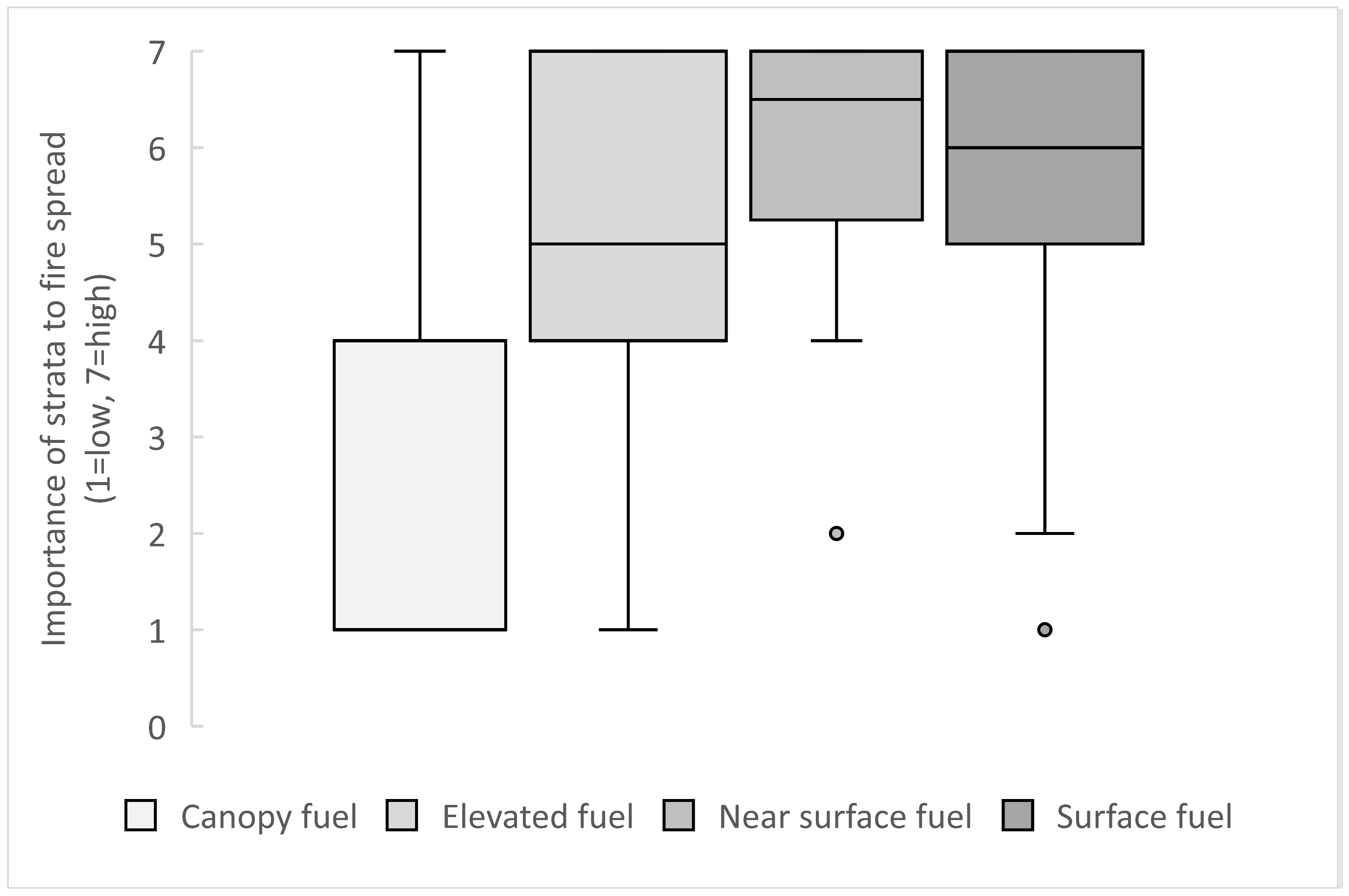
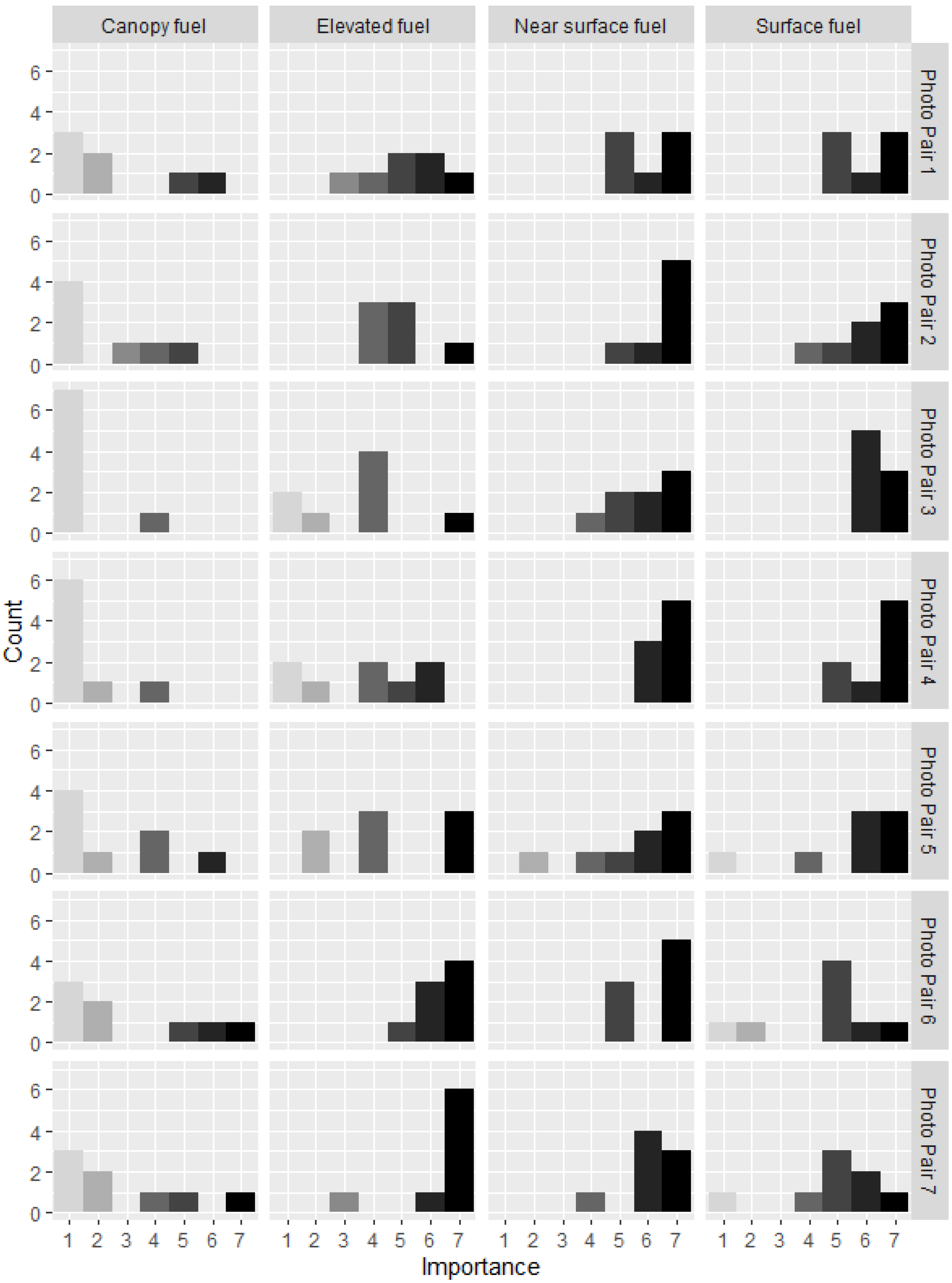
Figure 1. Photographs of coastal mallee on Kangaroo Island, South Australia, (a,b) and semi-arid mallee shrublands in northern Eyre Peninsula, South Australia, (c,d), contrasting vertical and horizontal connectivity from eye level and oblique aerial perspective.
Fire 07 00128 g001
Figure 2. Diagram of constraints to fire spread in shrublands illustrating how wind, fuel moisture and fuel spacing changes affect sustainability of fire spread.
Fire 07 00128 g002
Figure 3. Example pair of photos of coastal mallee shrublands provided during the expert workshop and used to rate the importance of fuel strata to fire spread.
Fire 07 00128 g003
Figure 4. Boxplot of participants’ (n = 8) responses to the importance of fuel strata to fire spread from photographs of coastal mallee shrublands (n = 7). Note the median importance for canopy is 1.
Fire 07 00128 g004
Figure 5. Combined results for all shrubland fire expert workshop participants for each photographic pair in section 1 (Appendix A.1) ranking the importance of fuel strata to fire spread in coastal mallee shrublands from low importance (1) to high importance (7).
Fire 07 00128 g005
Figure 6. Histogram of participant responses (n = 8) to questions: (a) Which height metric has the most influence on sustained fire spread in shrublands? (b) Which strata horizontal cover/continuity is most important to fire spread thresholds in shrublands? (c) Which measure of horizontal cover/continuity has the most importance to fire spread thresholds in shrublands? (d) Which vertical fuel metric has the most influence of fire spread (and crown fire) thresholds in shrublands? (e) Which height metric has the most influence on fire spread and crown fire behaviour in shrublands? (f) Which strata bulk density is most important to fire spread in shrublands?
Fire 07 00128 g006
Table 2. Median scores of all participants’ (n = 8) response to the importance of fuel strata to fire spread in coastal mallee shrublands on a Likert-scale of 1 (low) to 7 (high) from paired photographs.
Paired Photo No.CanopyElevatedNear-SurfaceSurface
12566
21576
31466
41477
52466
62775
72765
Summary of all pairs1576
Table 3. Summary results from participants (n = 8) of expert workshop results rating the contribution of fuel metric categories to fire spread based on photos of shrublands (n = 7).
Fuel Metric ClassNumber of Times Selected as Most ImportantNumber of Times Given as Option 1
Connectivity27
Cover38
Load16
Density14
Height010
1 Options were not evenly distributed in frequency when presented to participants.
Table 4. Average scores of weightings of fuel metrics in coastal mallee based on responses from section 2 (Appendix A.2) of the expert workshop on a scale of 1 (low contribution to fire spread) to 100 (high contribution to fire spread), ordered from highest to lowest contribution to fire spread for each photo pair.
Paired Photo No.Fuel MetricAverage Score
Photo Pair 1Surface fuel cover27
Elevated fuel density26
Near-surface fuel height23
Gap between elevated and canopy14
Canopy fuel height11
Photo Pair 2Near-surface fuel density35
Surface fuel load31
Elevated fuel height18
Canopy fuel cover9
Overall bulk density8
Photo Pair 3Surface fuel connectivity42
Near-surface fuel cover29
Near-surface and elevated fuel load19
Elevated fuel height8
Canopy height3
Photo Pair 4Surface fuel cover35
Near-surface vertical connectivity29
Surface fuel load26
Elevated to canopy gap9
Canopy fuel cover1
Photo Pair 5Near-surface fuel load34
Surface fuel cover25
Elevated fuel density24
Elevated to canopy gap15
Canopy fuel height1
Photo Pair 6Near-surface to elevated connectivity41
Elevated to canopy gap29
Elevated fuel height21
Surface fuel depth8
Canopy fuel cover1
Photo Pair 7Near-surface fuel cover49
Elevated fuel load29
Surface fuel depth13
Canopy fuel height8
Canopy fuel cover1
Table 5. Results of workshop section 4 (Appendix A.4) questions comparing importance of coastal mallee fuel structure metrics within a fuel stratum on a scale of 1(low importance) to 7 (high importance).
QuestionFuel MetricAverage Score
Importance of surface fuel metricsLitter cover6.1
Litter density4.4
Litter depth3.3
Litter weight (fuel load)2.4
Importance of near-surface fuel metricsNear-surface cover6.0
Vertical Connectivity to elevated fuel (or gap size)6.0
Live:Dead ratio5.4
Near-surface height5.1
Near-surface fuel load3.4
Near-surface bulk density2.9
Importance of elevated fuel metricsElevated fuel cover6.1
Live:Dead ratio4.6
Gap between elevated and canopy base4.5
Elevated fuel height4.4
Elevated fuel density3.8
Elevated fuel load2.8
Importance of canopy fuel metricsCanopy cover4.8
Canopy base height4.6
Canopy height3.3
Canopy bulk density1.9
Canopy load1.8
Importance of hazard scorePhysical measure of fuel important in fire spread thresholds6.3
Visual fuel hazard method important in shrublands4.9
Data derived hazard score important in shrublands 3.4
Hazard score for assessing fuel for prescribed burning2.8
Disclaimer/Publisher’s Note: The statements, opinions and data contained in all publications are solely those of the individual author(s) and contributor(s) and not of MDPI and/or the editor(s). MDPI and/or the editor(s) disclaim responsibility for any injury to people or property resulting from any ideas, methods, instructions or products referred to in the content.

