Abstract
The Santa Elena province in Ecuador has outstanding geological potential in petroleum, mining and geosite resources. All the wealth of palaeontological samples and their inherent link to the history of this territory require a recognised museum with educational and scientific material to support the potential and promotion of geotourism development. The Megatherium Palaeontological Museum is located in this province and was the first Palaeontological Museum in Ecuador. It exhibits samples corresponding to the Late Pleistocene Megafauna that inhabited the area. This study aims to evaluate the museum (a geoheritage element) as a possible (palaeontological) geosite by analysing its contributions to the geoheritage of the Santa Elena province. Thus, we also aim to enhance the geotourism of the area and promote its collections as a geotouristic attraction. The methodological process was based on: (i) information processing and systematisation in the museum and its environment; (ii) assessment of the museum’s geological interest through the method of the Geological Survey of Spain, the Brilha method and the Geosites Assessment Model; and (iii) a qualitative evaluation using the Delphi and the Strengths, Weaknesses, Opportunities and Threats methodologies to define strategies and proposals for museum development. Based on the results of the applied quantitative assessment, the museum has a “very high” (277/400) degree of geological interest, due to the high values of scientific (310/400), academic (310/400) and touristic (210/400) interest. In this same way, the results obtained through the Brilha method reflect a high scientific (290/400), educational (280/400), and tourist (315/400) interest and a low degradation risk (190/400) value in the museum. Furthermore, the applied Geosites Assessment Model shows the museum as a geosite with high main and additional values, placing it between the Z23 and Z33 fields of the global valuation matrix. The evaluation approached through Delphi analysis and Strengths, Weaknesses, Opportunities and Threats matrix allowed us to propose improvement strategies to take advantage of the museum resources as an alternative that strengthens the geotouristic development of the area.
1. Introduction
Natural diversity is a concept that integrates biodiversity and geodiversity [1]. According to [2,3,4], geodiversity is the variability of Earth’s surface materials, landforms and physical processes (abiotic elements). According to Rojas [5], geodiversity is the number and variety of structures (sedimentary, tectonic and geological materials—minerals, rocks, fossils and soils) that constitute the substratum, above which the organic—including the anthropic—activity is settled. The term geodiversity considers natural geological features such as rocks, soils and hydrological components in its definition [1,6]. In addition, geodiversity includes the evolution of these elements by geological, geomorphological, hydrological and anthropogenic processes [7,8,9]. According to [10,11], geodiversity should be considered in the analysis and study of the geoheritage territory to highlight the evolution of the site and, complementarily, the development of existing biological processes.
All geological sites of high scientific, cultural and educational value are considered geoheritage [1,3,12,13]. Furthermore, the definition of some elements as geoheritage highlights the geological and geomorphological characteristics of the territory to conserve and rescue these elements [14,15,16]. In addition, it allows scientists to monitor the evolution of the geobiological profile through systematised management and planning [17]. Therefore, the quantitative assessment of geoheritage is an essential topic in Europe, North America and Oceania, as it allows for the proper monitoring and sustainable development planning of sites with geological potential [18,19,20].
The term geoconservation is defined by the need to conserve geoheritage [21]. According to Burek & Prosser [14], geoconservation is the action taken with the intent of conserving and enhancing geological and geomorphological features, processes, sites and specimens. In recent years, the United Nations Educational, Scientific and Cultural Organization (UNESCO) has implemented sustainable strategies to preserve the life, cultures, ecology and knowledge of island regions [22,23]. In terms of specific geoconservation programmes, some programmes protect sites of high geodiversity potential, such as the federal geoheritage programmes in the United States [7,24].
According to Carrión et al. [25], geoheritage is formed by all those places or points of geological interest, defined as sites or geosites, that stand out from their surroundings due to their scientific and/or educational value. According to Newsome & Dowling [26], geosites are sites of geological interest with high scientific, educational and touristic value, representing the geoheritage of an area. Different types of geosites exist [27,28]: historical, geomorphological, geothermal, hydrological and hydrogeological, neotectonic, palaeogeographical, palaeontological, pedological and radio-geological.
The evaluation of geosites is based on applying different methods to identify their scientific, educational, and tourist potential. An example of such processes is the IELIG method (acronym in Spanish “Inventario Español de Lugares de Interés Geológico”) [29]. This method has a systematic evaluation process, which proposes a series of variables to evaluate geosites, such as intrinsic value, didactic potential and recreational tourism. Examples of its application are in the Las Loras Geopark and Comarca de Molina de Aragón-Alto Tajo Geopark (Spain) [30]. The Brilha method is a procedure that proposes a quantitative assessment of geosites with a more geoconservation-oriented approach [1]. This method has been implemented in different studies like the Sierra Mágina Natural Park (Spain) [31] and Arouca Geopark (Portugal) [32]. Finally, the Geosites Assessment Model (GAM) method is a preliminary model for the physical assessment of geosites considering a series of scientific/educational, aesthetic/scenic, protection, functional use and tourism variables [33]. Among the geosites assessed by GAM is the Vrdnik coal mine (Serbia) [34] and the “El Sexmo” tourist mine (Ecuador) [35].
It is essential to consider the movable geoheritage (vulnerable parts of earth science exposed to natural degradation or a human action that can or must be protected ex situ), which also includes geographical heritage. Their inclusion into a museum collection often represents the only chance to preserve these invaluable inanimate natural monuments [36]. According to [37], the educational potential of geodiversity elements, such as outcrops of widespread rock types that are not protected or included in geosite inventories, could be used in informal education activities.
Some museums preserve natural elements with particular characteristics and are recognised by UNESCO [38,39] such as the Liverpool Maritime Museum (Merseyside Maritime Museum) (England), the Marsala Regional Archaeological Museum (Italy), the Museum of the World Oceans/Icebreaker Krassin (Russia) and the Geomining Museum (Instituto Geológico y Minero de España in Madrid) (Spain). There are also museums in Latin America with collections of mineralogical and palaeontological interest [38,40,41], such as the Archaeological Museum of Campeche (Mexico), the Mineralogical School of Mineral Science and Technology Museum in Ouro Preto (Brazil) and the Geology Museum (Universidad Nacional Autónoma de México, UNAM) (Mexico).
Museums in Ecuador exhibit cultural and natural heritage. For example, the Museo Nacional del Ecuador has an archaeological collection with 40,000 elements that reflect the evolution of ancient Ecuadorian cultures. These museums mainly contribute to the knowledge of the historical and cultural riches of the past [42,43]. In addition, some museums (e.g., palaeontological, mineralogical) in Ecuador are recognised in geopark projects as having a high scientific value of natural elements.
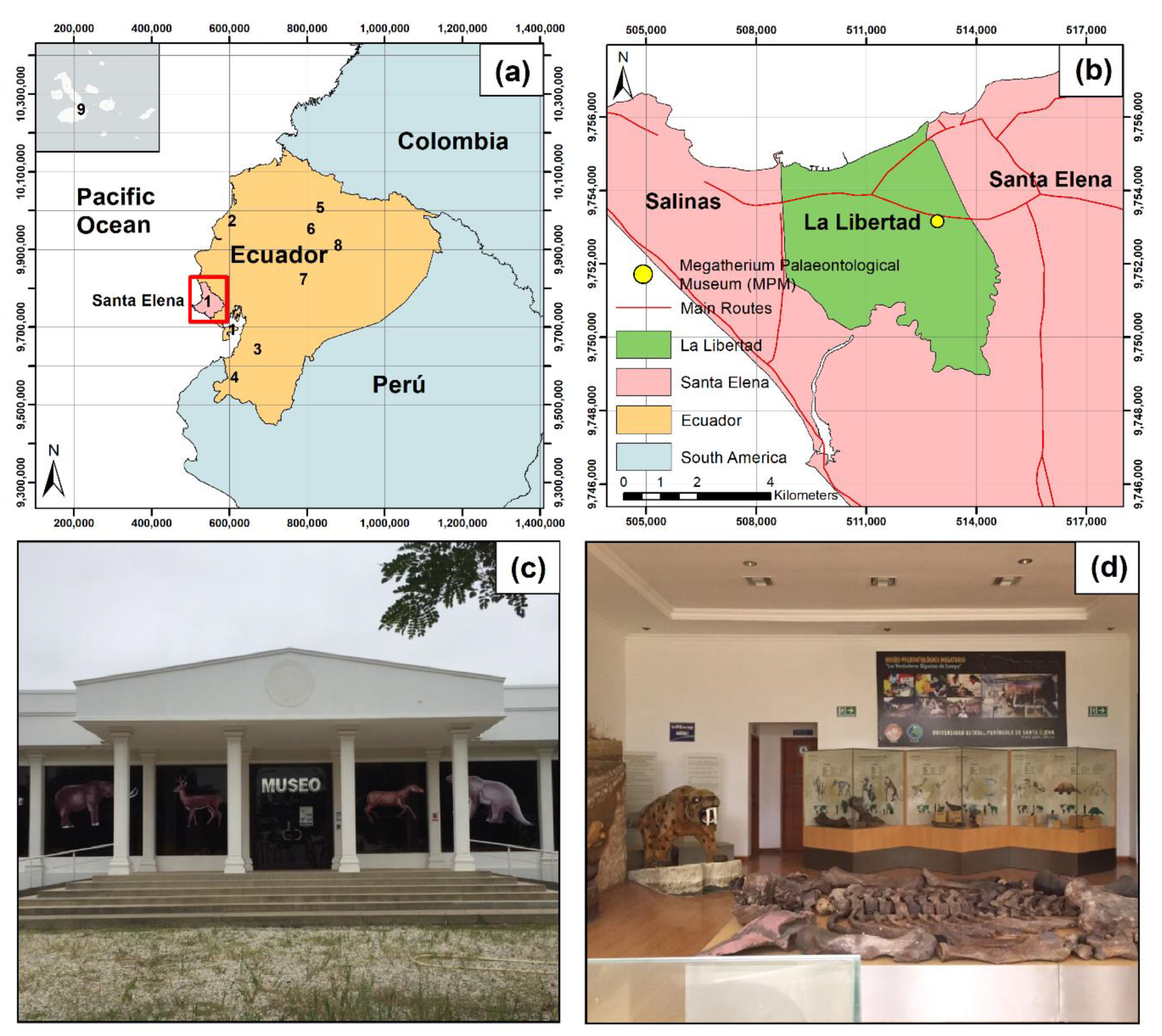
The creation of the Ecuadorian Geoparks Committee and the official declaration of Imbabura Geopark as a UNESCO Global Geopark in 2019 [44] helped in the creation of new projects for geoparks (Figure 1a) such as the Tungurahua Volcano Geopark project, Napo-Sumaco Geopark project [45], the Santa Elena Peninsula Geopark project [46], the Galapagos Geopark project, the Puyango Petrified Forest Geopark project [47], the Jama Pedernales Geopark project, the Quito Geopark Project and the “Ruta del Oro” (Gold Route) Geopark project [25].

Figure 1.
(a) The geographical location of the Santa Elena province, Ecuador. Information on the main geopark initiatives in Ecuador (1. Santa Elena Peninsula Geopark Project, 2. Jama Pedernales Geopark Project, 3. Ruta del Oro Geopark Project, 4. Puyango Petrified Forest Geopark project, 5. Imbabura, UNESCO Global Geopark, 6. Quito Geopark Project, 7. Tungurahua Volcano Geopark Project, 8. Napo-Sumaco Geopark Project, and 9. Galápagos Geopark Project); (b) Location of the Megatherium Palaeontological Museum (MPM), canton La Libertad; (c) Front view of the outer part of the MPM; (d) Internal section of the MPM (sabre-toothed tiger specimen and exhibits of bones and fragments).
Although there has long been a remarkable appreciation of places of outstanding natural beauty or geographical phenomena by the population, it was not until the 1990s that geotourism appeared [48,49]. According to Dowling [50], geotourism is sustainable tourism with a primary focus on experiencing the Earth’s geologic features in a way that fosters environmental and cultural understanding, appreciation and conservation and is locally beneficial. Furthermore, according to [6], geotourism development has relationships with the geodiversity values and characteristics and degrees of protection.
In the case of the Santa Elena Peninsula Geopark project (Figure 1a), an initiative that addresses the characterisation of a territory located in western Ecuador [46], sites of geological, mining and industrial interest with the potential to be used in tourism activities have been inventoried and evaluated [51]. In addition, the studies carried out have taken into account sites of cultural and architectural interest specific to the region. Among the inventoried and evaluated sites, the most important ones are: the Megatherium Palaeontological Museum of the UPSE University, the Amantes de Sumpa museum, the Real Alto cultural complex (located in Chanduy) and the Chocolatera cliff in the Puntilla de Santa Elena reserve. In general, Santa Elena province has remarkable cultural, natural, intangible, and geological characteristics with the potential to be officially recognised as natural or cultural heritage [51]. The main economic activities in the area are agriculture, livestock breeding, mining and handicrafts. Tourist activity is also noteworthy, although it is focused on traditional tourism (beach) where geotourism (cultural and natural) has not reached its full potential [52,53].
The present study focuses on the characterisation of the Megatherium Palaeontological Museum as a geoheritage element. In concrete terms, this study aims to evaluate the MPM as a geosite of geotourism palaeontological potential through semiquantitative (IELIG, Brilha and GAM) and qualitative (DELPHI and SWOT) methods for the knowledge of geotourism development.
2. Megatherium Palaeontological Museum
The Megatherium Palaeontological Museum (MPM) belongs to the UPSE University and is located in the canton of La Libertad, Santa Elena, Ecuador (Figure 1a,b). This museum (Figure 1c,d) is considered the first palaeontological museum in Ecuador [54] and was founded on 2 February 2008. The museum’s significant collections correspond to the Late Pleistocene Megafauna (50,000 to 8000 years). These remains were extracted from the Tanque Loma sector (located in one of the largest and most important fossil deposits in South America) [55]. In addition, this palaeontological exhibition centre has palaeontological findings, where professionals in the area share scientific information on the existing elements (524 bones and 2,969 fragments such as tibiae, ribs, pelvises, femurs and jaws) [56,57].
The museum has an extensive collection of fossils. These collections correspond to terrestrial (e.g., megatherium mammal) and marine (e.g., shells, sharks) fossils [58]. Among the main species of animals in the collection are the Megatherium (Species: laurillardi; Weight: four tonnes; Size: 4-6 m), the Mastodon (Species: waringi; Weight: four tonnes), the Pampaterio (Species: occidentails; Weight: two tonnes), the Glosoterio (Species: tropicorum; Weight: four tonnes; Size: 3–4 m), the American Horse (Species: santaelenae; Weight: 400 kg) and the Deer (Species: virginaunus; Weight: one tonne) [59]. Figure S1 presents images of these fossils.
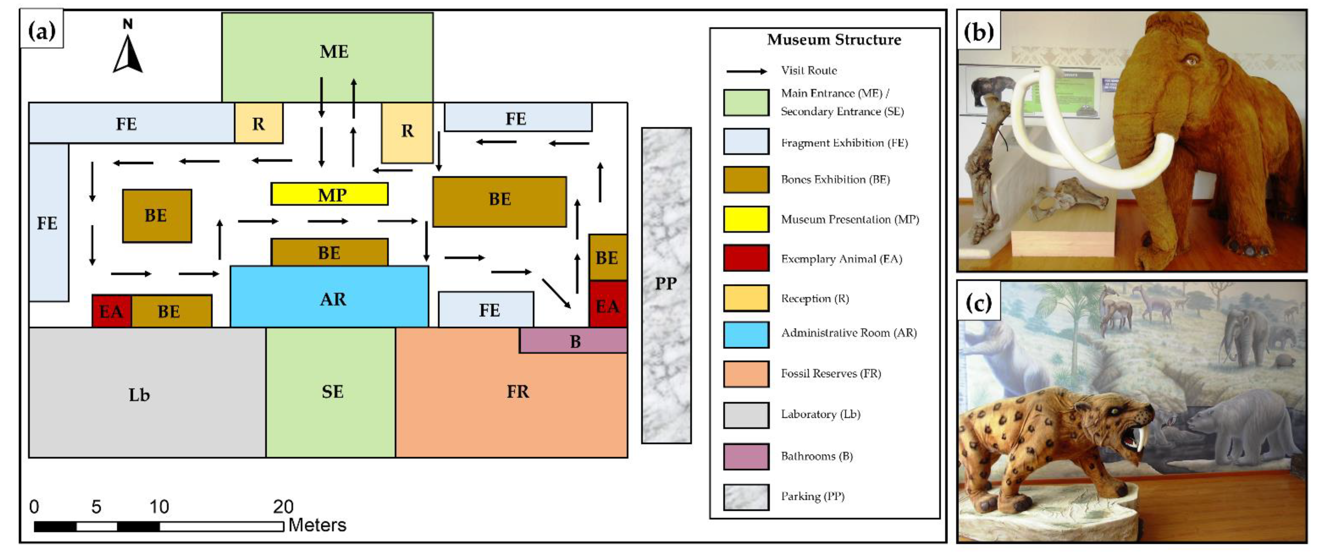
The MPM has 11 different sections (Figure 2a). Inside the MPM are the reception room, the administrative room, the laboratory and the storage room (cellar). In addition, the fossil remains are preserved in five display boards (large bones) and four showcase areas (fragments). It has a parking area suitable for cars and buses, and the main entrance suitable for receiving visiting groups.
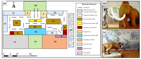
Figure 2.
(a) MPM map with a description of the exhibition room’s structure. (b,c) Reproductions of Mammoth and Sabre-toothed feline specimens in the exhibition room (Exemplary Animal (EA)).
3. Materials and Methods
This research was carried out in three phases (Figure 3): (i) processing and systemizing information from the MPM and its environment; (ii) semiquantitative assessment of the MPM using evaluative matrices of the IELIG, Brilha and GAM methods; and (iii) qualitative analysis using the DELPHI method and SWOT analysis.
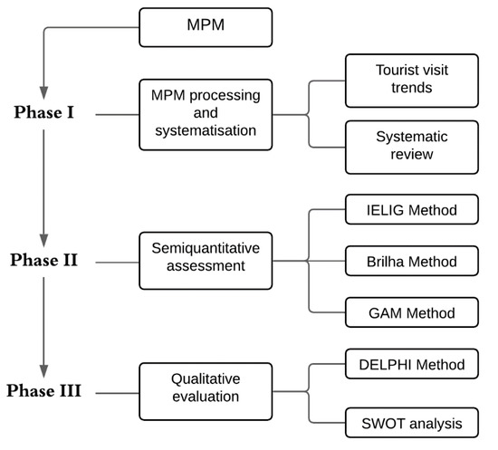
Figure 3.
A flowchart of the methodology used in this study.
3.1. Phase I: Processing and Systematisation of Information
This first phase carried out an analysis of the annual and monthly tourist inflow, data that were compiled in the reports presented on the official website of the Megatherium Palaeontological Museum (MPM) (e.g., [54,60,61,62,63]). In addition, the museum provided photographs of some of the bones and fragments on exhibit inside the museum (Supplementary Materials Figure S1). This work presents a compilation of information from projects and scientific articles related to MPM (e.g., [35,64,65,66,67,68,69,70,71,72,73]). Finally, this study generated general content on the history, culture, interest and representativeness of the MPM.
3.2. Phase II: Semiquantitative Assessment. IELIG, Brilha and GAM
In this phase, the MPM evaluated using the IELIG [29], Brilha [1] and GAM [33] methods. The evaluation of each method was carried out with the support of four experts on geosite analysis and assessment. Their professional opinion was based on the unanimous value of each criterion. Subsequently, the obtained information was classified into digital matrices for more straightforward data processing.
3.2.1. Assessment with IELIG Method
The applied IELIG method [29] is an evaluation procedure of different parameters, with scores of 0, 1, 2 and 4, where 0 is the lowest value and four the highest [29]. These parameters are grouped under three headings: (i) value class (intrinsic value, the value linked to the potential for use and protection), (ii) criteria (evaluation variables) and (iii) interest to be assessed (scientific (Sc), academic (Ac) and touristic (To)).
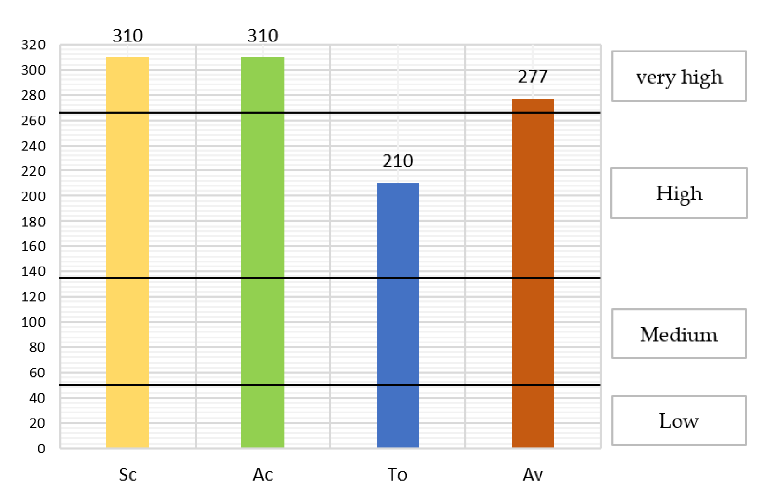
The total value is the weighted sum of the results obtained for each interest. This value allows classifying the site geological interest as low (<50), medium (50–134), high (134–266) and very high (>267).
The Degradation Susceptibility (DS) and the Protection Priority (PP) values are based on the results obtained in Fragility (F) and Vulnerability (V). Table 1 shows the variables, the evaluation and the weight for obtaining the necessary data in the DS equation.

Table 1.
Overview of the main indicators of the IELIG, Brilha and GAM approaches.
Once the F and V are known, the Degradation Susceptibility (DS) is given by the following Equation (1):
The total Degradation Susceptibility (DS) value has a determined weight: low (<13), medium (13–67), hight (68–199), very hight (200–399) and maximum (400).
With the value of the Degradation Susceptibility (DS) and the scientific (Sc), academic (Ac) and tourist (To) values, the results are ordered according to the Equations (2)–(5) of the scientific (PpSc), academic (PpAc), tourist (PpTo) and global (Pp) aspects as follows:
3.2.2. Assessment with Brilha Method
The Brilha method [1] was applied to the MPM to determine its value as a geosite. This quantitative assessment procedure mainly considers geosite geoconservation events [1]. In general, this procedure establishes: (i) Scientific Value (SV), (ii) Potential Educational Use (PEU), (iii) Potential Tourism Use (PTU) and (iv) Degradation Risk (DR). The criteria represented by indicators score from 1 to 4 points, with different weights.
In the Degradation Risk (DR) variable, there is a classification based on the total value obtained from the assessment, established in a range (low <200, medium 201–300 and high 301–400) [1].
3.2.3. Assessment with Geosites Assessment Model (GAM) Method
The application of the GAM method [33] focused on defining the site’s potential from two groups of indicators: main values (Scientific/Educational, Scenic/Aesthetic and Protection) and additional values (Functional and Touristic). The process considers scores ranging from 0 to 1 [33]. Subsequently, the values obtained for each indicator are reflected in a matrix (main value on the X-axis and additional value on the Y-axis), which will allow the evaluators to obtain a panoramic image of the current state of the site.
3.3. Phase III: Qualitative Evaluation. DELPHI and SWOT Analysis
This phase carried out a qualitative analysis by UPSE University experts using the DELPHI methodology [74]. The methodology allowed the researchers to understand the current state of the MPM.
In addition, a Strengths, Weaknesses, Opportunities and Threats (SWOT) analysis has been carried out [75], considering the characteristics of the MPM and its environment. The analysis made it possible to determine the site’s geotourism potential and propose initiatives for the efficient and effective use of the museum.
4. Results
4.1. MPM Processing and Systematisation
The visitor register reports that the MPM reached 14,400 visits in the period from 2018 to 2020. The year 2019 has the highest register (7253 visits) (Figure 4a). However, in the year 2020, there is a decrease in tourist influence mainly associated with the sanitary situation caused by COVID-19. This problem led to the temporary closure of the MPM, which interrupted visits from March until the end of 2020. The development of virtual activities and visits to the museum have been addressed as alternatives during the pandemic closure. However, it has not been possible to obtain these data in this study. In general, the available data indicate that the months with the highest number of visits are July (2019: 2113 visits) and October (2018: 963 visits) (Figure 4b).
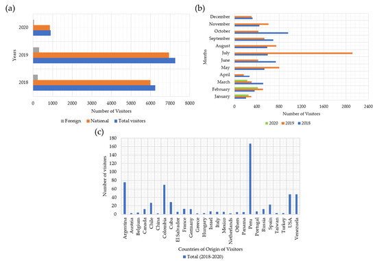
Figure 4.
(a) Data on annual visits (2018, 2019 and 2020) to the MPM; (b) Data on monthly visits to the MPM in the years 2018, 2019 and 2020; (c) Cumulative data on foreign visitors to the MPM in the period from 2018 to 2020.
Regarding the visit of foreign tourists, the collected data indicate that the highest number of visits (46.6%) corresponds to tourists from Peru and Argentina (Figure 4c).
Table 2 shows the projects, and scientific articles carried out by researchers from the UPSE University with the collaboration of other authors from other institutions (national and international). Two projects were carried out related to the museum’s tourism activities and development: “Megatherium-UPSE Museum: From Exhibition Hall to Natural History Museum” [64] and “Santa Elena Peninsula Geopark Project” [67]. These projects aim to strengthen the concept and geological assessment of the MPM through the development of scientific research. Finally, table presents a summary of the articles resulting from the research on the scientific content of the museum. These articles generally deal with geological assessment and palaeontological studies.
Table 2.
Projects and scientific articles related to the MPM by the UPSE University.
Analysis of the museum’s documentation and collection yielded relevant data on the representativeness of the available collection, the preservation degree of megafauna fossil remains, the heritage and geotourism potential of the museum and, above all, the uniqueness of the available collections. In detail: (i) concerning history, the museum’s name is shaped by discovering the sloth “Megatherium” and other finds of fossil remains; (ii) considering the culture, it presents a collection of 524 bones and 2969 fragments belonging to the Late Pleistocene megafauna that inhabited the Santa Elena province; (iii) from the point of view of tourist interest, analyses carried out by other authors indicate that the museum is of high interest; and (iv) regarding representativeness, the MPM has fossil elements of a particular national character and is considered the first palaeontological museum in Ecuador.
4.2. Semiquantitative Assessment with IELIG, Brilha and GAM Methods
This section presents the description of the main criteria (Table 1) used in the assessment of MPM using the Brilha [1], GAM [33] and IELIG [29] methods.
4.2.1. Assessment with IELIG Method
The museum evaluation with the IELIG method indicates a very high rating in terms of scientific interest (310/400) and academic interest (310/400). On the other hand, the touristic interest shows a high value (210/400). In general, based on the results of Sc, Ac and To, the degree of geological interest is “very high” (Figure 5).

Figure 5.
Results obtained regarding the value of Scientific (Sc), Academic (Ac), Tourist (To) and Average (Av) interest.
The value of fragility (160/400) and vulnerability (130/400), with intermediate results.
The value of the susceptibility to degradation (SD) (Table 3) indicates a medium score (52/400). The estimated value refers to the existing fossil collection. The potential damage mainly conditions the estimated value of 52/400 during the museum visit and the collections vulnerability. An SD reduction requires the improvement of the infrastructures that hold the collections on display to the public.
Table 3.
Degradation susceptibility (DS) value.
Finally, Table 4 shows a moderate protection priority for the site. However, its tourism protection priority is an issue that needs to be improved.
Table 4.
Protection values: scientific (PpSc), academic (PpAc), touristic (PpTo) and global (Pp).
4.2.2. Evaluation with the Brilha Method
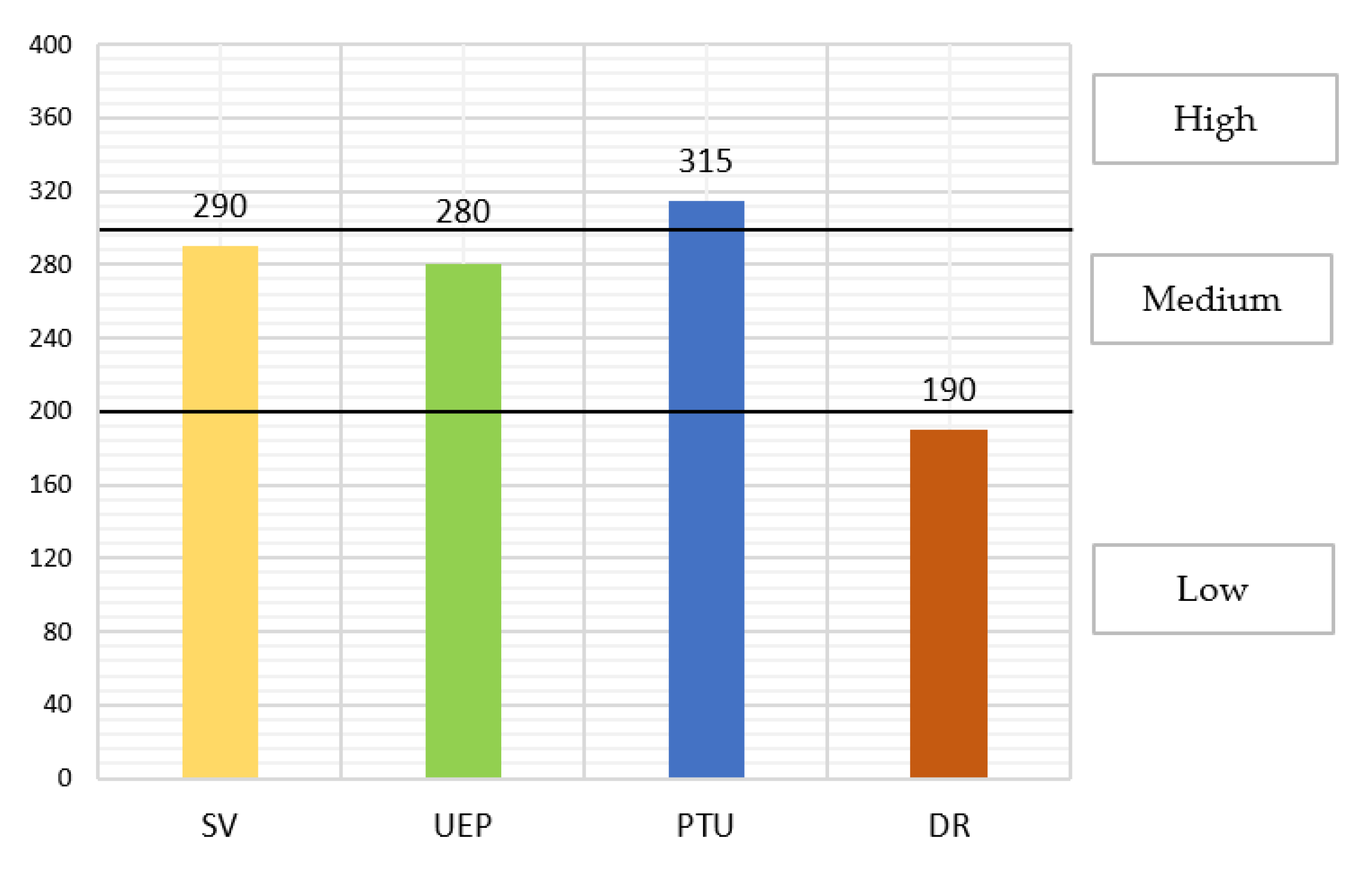
In the Brilha method, the evaluation shows moderate values of the variables in the Scientific Value (SV) (290/400) and Potential Educational Use (PEU) (280/400). However, the Potential Tourism Use (PTU) score is higher (315/400) (Figure 6). Degradation Risk (DR) is low (190/400) due to the good logistics and legal protection of the museum.

Figure 6.
Results obtained regarding the Scientific Value (SV), Potential Educational Use (PEU), Potential Tourism Use (PTU) and Degradation Risk (DR).
4.2.3. Assessment with the GAM Method
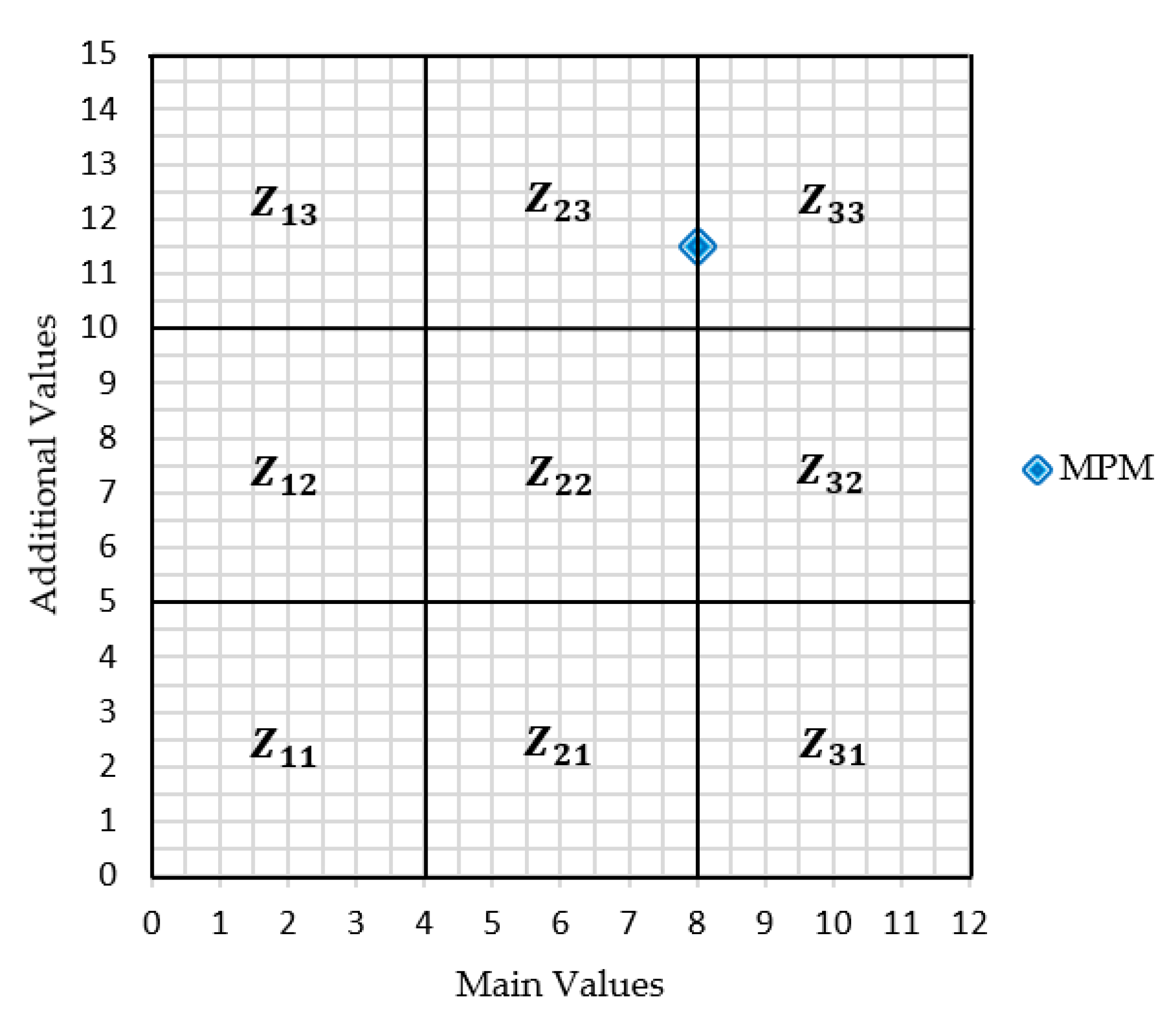
The GAM assessment shows high values ranging primarily between 0.5 and 1, with an average score of 0.75. The core variables, such as the Scientific Educational Value (VSE), Scenic/Aesthetic (VSA) and Protection (VPr), add up to a total score of 8/12. On the other hand, additional values such as Functional (VFn) and Touristic Values (VTr) show a higher value (11.5 points) (Figure 7). The results place the MPM assessment between the Z23 and Z33 fields (Figure 8), which means it has a high geotourism potential.
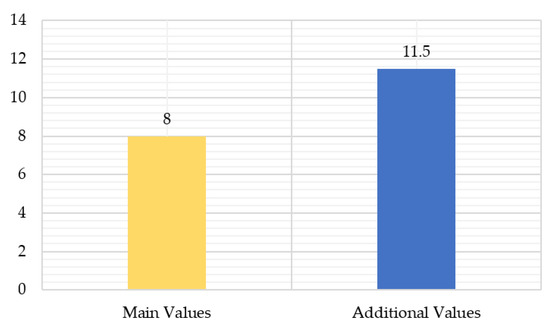
Figure 7.
Results obtained regarding Main Values and Additional Values.
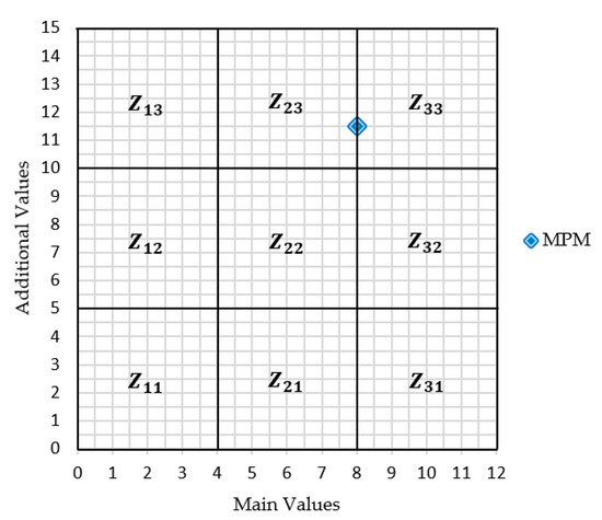
Figure 8.
Position of the results obtained in GAM.
4.3. DELPHI and SWOT Analysis
4.3.1. DELPHI Method
The results obtained in the semiquantitative assessment indicate that the MPM is a site with geotourist potential oriented towards ex situ geoconservation. Therefore, the scientific content, service, logistics and state of infrastructure are critical variables in the MPM valuation process. However, it is necessary to consider actions caused by internal and external sources that negatively influence the museum’s content, such as the constant vehicular traffic (less than 100 m), visitors who do not respect the signage and the lack of constant maintenance of the museum’s infrastructure. In addition, it is essential to promote the implementation of geotourism development strategies of the MPM at the national and international levels.
4.3.2. SWOT Analysis
The SWOT matrix analysis was generated based on the criteria used in the DELPHI method (Table 5). This analysis shows an overview of the current conditions and strategies that affect geotourism development in the MPM.
Table 5.
SWOT analysis (qualitative matrix) of the MPM.
5. Discussion
The present study allowed us to characterise the scientific, academic and tourist interest of the Megatherium Palaeontological Museum (MPM) as a geosite using qualitative and semiquantitative methods and thus broaden the knowledge about its geotourism potential. The obtained results indicate that the museum can be considered an excellent place for the generation of geotourism, corroborating the information provided in previous studies [51,57]. In concrete terms, the study carried out by Herrera et al. [51], applying the “Criteria of Geological relevance, Representativeness, Geotouristically prominent Site, Interpretation, and Conservation (GREGSIC)” method, indicates that the MPM has a “very high” interest due to its scientific, educational and touristic value. Furthermore, in this study, when applying the IELIG, Brilha and GAM methods, the MPM presented a “high” interest of global interest in all three evaluations. Therefore, the MPM can be considered to reach the level of heritage recognition as it has a specific content and a suitable environment for preserving fossil elements [77]. However, we also found that it is essential to monitor the obtained values (scientific, educational, touristic) in terms of the conservation of its collections and its limited geotouristic progress. The inclusion of strategies and programmes for the conservation and promotion of the museum are pending tasks that must be addressed in further studies (e.g., [56,78]).
There are museums worldwide that have been evaluated using the three methods (IELIG, Brilha and GAM) for their enhancement. In the evaluations, these museums score “high” and “very high” [79,80,81,82] due to their scientific and geotourism potential regarding indicators such as representativeness, rarity, logistical infrastructure, accessibility and uniqueness. However, some museums are affected by anthropogenic threats (mainly open-air museums, e.g., [83,84]). In contrast, the MPM was found to have high values in indicators such as representativeness, knowledge of the site, rarity, informational and didactic content, level of interpretation, vulnerability, use limitations, the proximity of recreational areas and tourism infrastructure. In addition, the museum collections are well protected against anthropogenic manipulation, as vulnerability and protection criteria conditions are appropriate.
In more detail, the results obtained in the MPM evaluation show that:
- According to the IELIG method [29], the museum can become a cultural model on a national level. In addition, its degree of knowledge, rarity, the spectacular nature of the museum and its tourism potential make it a destination for research and geotourism [46].
- According to the Brilha method [1], the museum has an adequate study area to illustrate elements related to palaeontology. In addition, the scientific progress (integrity and geological occurrence) and its historical, cultural and heritage value make the museum a place of educational and touristic interest. The risk of degradation is low, as the museum’s fossil elements are protected.
- According to the GAM method [33], the MPM has a unique scientific value, with high values of didactic and exemplary characteristics (Figure 8). However, its scenic/aesthetic value is intermediate, as the logistics of the museum do not present a natural environment and industrial activities are less than 5 km away.
Despite the scientific potential of the MPM, the DELPHI and SWOT methods show some weaknesses and threats that negatively affect the geotourism development of the museum. For example, the lack of publicity methods, lack of links and limited funding, low ICTs (Information and Communication Technologies) index, lack of relationship with national and international museums and limited local interest in the museum. According to Álvarez & Cedeño [56], implementing a promotion plan would allow the museum to obtain optimal solutions to the threat of social and academic disinterest. The present study includes strategic content that could help improve the geotourism performance of the MPM (Table 5). This proposed plan would encourage the development of the museum and the whole Santa Elena Peninsula Geopark Project. In concrete terms, through alliances with private and governmental entities, the generation of public events through online technological resources [85] and, mainly, the incorporation of society in the initiatives to exploit geoheritage.
6. Conclusions
The evaluation carried out using the IELIG, Brilha and GAM methods shows a high scientific, educational and touristic interest of the MPM, qualifying it as an ex situ geoheritage element of palaeontological character with applications in geoturism. Due to the discovered fossil remains that form part of the museum’s collection, it can be considered a place with unique characteristics at local and national levels. The MPM can be part of the geotourism potential sites of the Santa Elena province to validate its importance in the context of the Santa Elena Peninsula Geopark Project.
Despite outstanding studies showing a high scientific interest in the MPM, annual visitor trends show an intermediate interest from national and foreign tourists, with approximately 14400 visits in the last three years. Therefore, the implementation of strategies is fundamental to enhance geotourism in the MPM. Financial and publicity support by entities interested in making strategic links related to geotourism in the context of geoconservation is essential.
The DELPHI and SWOT analyses were fundamental to gain a deeper understanding of the current state of the museum. These methodologies proved that the MPM is a site of geotourism potential and, can be a base for social and economic development. In addition, these analyses revealed some weaknesses of the museum, such as its limited links with private and governmental entities, low ICTs index, limited funding, and lack of relationship with national and international museums. Based on the criteria mentioned above, we propose strategies focused on solving these weaknesses, for example, the search for external funding, the promotion of the MPM within the framework of the Santa Elena Peninsula Geopark project, the generation of alliances with academic and governmental entities, the implementation of interdisciplinary programmes (academic and tourism) and, finally, the development of tourism strategies.
Supplementary Materials
The following are available online at https://www.mdpi.com/article/10.3390/heritage4030067/s1, Figure S1: Fossils from the Palaeontological Museum: (a) Fossil bones of Megatherium; (b) Fossil Mastodon ribs and vertebrae; (c) Evidence of Pampaterio and American Horse; (d) Evidence of Giant Glosoterio and Deer.
Author Contributions
Conceptualization, G.H.-F., K.E., P.C.-M., and C.M.-F.; methodology, G.H.-F., K.E., C.M.-F., P.C.-M. and E.B.; validation, G.H.-F., P.C.-M. and E.B.; formal analysis, G.H.-F., C.M.-F., P.C.-M. and E.B.; investigation, K.E. and C.M.-F.; data curation, K.E. and C.M.-F.; writing—original draft preparation, G.H.-F. and C.M.-F.; writing—review and editing, G.H.-F., E.B., C.M.-F., P.C.-M. and K.E.; visualization, C.M.-F.; supervision, G.H.-F., P.C.-M. and E.B. All authors have read and agreed to the published version of the manuscript.
Funding
This research was funded by the UPSE University research project: “Santa Elena Peninsula Geopark Project” with code no. 91870000.0000.381017.
Institutional Review Board Statement
Not applicable.
Informed Consent Statement
Not applicable.
Data Availability Statement
Not applicable.
Acknowledgments
This work has been possible thanks to the projects “Santa Elena Peninsula Geopark Project” of the UPSE University project with code no. 91870000.0000.381017; “Factores Geoambientales de los Pozos Petroleros y su Incidencia en el Desarrollo Territorial en los Cantones Salinas y La Libertad de la Provincia de Santa Elena”, with code no: 91870000.0000.385428; and the project “Registry of geological and mining heritage and its impact on the defense and preservation of geodiversity in Ecuador” of the ESPOL Polytechnic University with code CIPAT-01-2018. We thank María Jaya and Maribel Aguilar-Aguilar for their recommendations to improve the study. We also thank Tímea Kovács for her extensive English language review. Thanks to Shirley de la Cruz M.Sc. and Rosa Maldonado, M.Sc. of the UPSE University’ Megatherium Palaeontological Museum for all their help in obtaining the digital material (photos of bones and fragments) despite the COVID-19 pandemic. We are also grateful for the support of Victor Coronel Ortiz M.Sc. for his help in processing the digital material. This work is based on previous initiatives sponsored by the Red Minería XXI (CYTED: 407310RT0402, IGME). Furthermore, we thank the reviewers and editorial committee for their observations and suggestions for improving the manuscript.
Conflicts of Interest
The authors declare that there are no publication conflicts about the digital material exhibited by the museum.
References
- Brilha, J. Inventory and Quantitative Assessment of Geosites and Geodiversity Sites: A Review. Geoheritage 2016, 8, 119–134. [Google Scholar] [CrossRef] [Green Version]
- Serrano, E.; Ruiz-Flaño, P. Geodiversity: A theoretical and applied coneept. Geogr. Helv. 2007, 62, 140–147. [Google Scholar] [CrossRef]
- Carrión-Mero, P.; Montalván-Burbano, N.; Herrera-Narváez, G.; Morante-Carballo, F. Geodiversity and Mining Towards the Development of Geotourism: A Global Perspective. Int. J. Des. Nat. Ecodynamics 2021, 16, 191–201. [Google Scholar] [CrossRef]
- Gray, M.; Gordon, J.E.; Brown, E.J. Geodiversity and the ecosystem approach: The contribution of geoscience in delivering integrated environmental management. Proc. Geol. Assoc. 2013, 124, 659–673. [Google Scholar] [CrossRef]
- Rojas, J. Los desafíos del estudio de la geodiversidad. Rev. Geográfica Venez. 2005, 46, 143–152. [Google Scholar]
- Kubalíková, L.; Drápela, E.; Kirchner, K.; Bajer, A.; Balková, M.; Kuda, F. Urban geotourism development and geoconservation: Is it possible to find a balance? Environ. Sci. Policy 2021, 121, 1–10. [Google Scholar] [CrossRef]
- Gray, M. Geodiversity: Valuing and Conserving Abiotic Nature, 2nd ed.; John Wiley & Sons: Chichester, UK, 2004. [Google Scholar]
- Kozlowski, S. Geodiversity. The concept and scope of geodiversity. Prz. Geol. 2004, 52, 833–837. [Google Scholar]
- Migoń, P. Granite Landscapes, Geodiversity and Geoheritage—Global Context. Heritage 2021, 4, 12. [Google Scholar] [CrossRef]
- Medina, W. Importancia de la Geodiversidad. Método de Inventarización y Valoración del Patrimonio Geológico. Ser. Correlación Geológica 2015, 31, 57–72. [Google Scholar]
- Carrión, P.; Herrera, G.; Briones, J.; Sánchez, C. La Geodiversidad, una componente de desarrollo sostenible. J. Sci. Res. 2018, 3, 36–42. [Google Scholar]
- Lazzari, M.; Aloia, A. Geoparks, geoheritage and geotourism: Opportunities and tools in sustainable development of the territory. Geoj. Tour. Geosites 2014, 13, 8–9. [Google Scholar]
- Herrera-Franco, G.; Montalván-Burbano, N.; Carrión-Mero, P.; Jaya-Montalvo, M.; Gurumendi-Noriega, M. Worldwide Research on Geoparks through Bibliometric Analysis. Sustainability 2021, 13, 1175. [Google Scholar] [CrossRef]
- Burek, C.V.; Prosser, C.D. The history of geoconservation: An introduction. Geol. Soc. London, Spec. Publ. 2008, 300, 1–5. [Google Scholar] [CrossRef] [Green Version]
- Prosser, C.D. Our rich and varied geoconservation portfolio: The foundation for the future. Proc. Geol. Assoc. 2013, 124, 568–580. [Google Scholar] [CrossRef]
- Carrión-Mero, P.; Borja-Bernal, C.; Herrera-Franco, G.; Morante-Carballo, F.; Jaya-Montalvo, M.; Maldonado-Zamora, A.; Paz-Salas, N.; Berrezueta, E. Geosites and Geotourism in the Local Development of Communities of the Andes Mountains. A Case Study. Sustainability 2021, 13, 4624. [Google Scholar] [CrossRef]
- García-Ortiz, E.; Fuertes-Gutiérrez, I.; Fernández-Martínez, E. Concepts and terminology for the risk of degradation of geological heritage sites: Fragility and natural vulnerability, a case study. Proc. Geol. Assoc. 2014, 125, 463–479. [Google Scholar] [CrossRef]
- Brilha, J. Geoconservation and protected areas. Environ. Conserv. 2002, 29, 273–276. [Google Scholar] [CrossRef] [Green Version]
- Serrano, E.; González-Trueba, J.J. Assessment of geomorphosites in natural protected areas: The Picos de Europa National Park (Spain). Géomorphologie Reli. Process. Environ. 2005, 11, 197–208. [Google Scholar] [CrossRef] [Green Version]
- Pereira, P.; Pereira, D.; Caetano Alves, M.I. Geomorphosite assessment in Montesinho Natural Park (Portugal). Geogr. Helv. 2007, 62, 159–168. [Google Scholar] [CrossRef] [Green Version]
- Crofts, R.; Gordon, J.E. Geoconservation in protected areas. In Protected Area Governance and Management; Worboys, G.L., Lockwood, M., Kothari, A., Feary, S., Pulsford, I., Eds.; ANU Press: Canberra, Australia, 2015; pp. 531–568. [Google Scholar]
- Caust, J.; Vecco, M. Is UNESCO World Heritage recognition a blessing or burden? Evidence from developing Asian countries. J. Cult. Herit. 2017, 27, 1–9. [Google Scholar] [CrossRef]
- Hong, S.-K. Biocultural diversity conservation for island and islanders: Necessity, goal and activity. J. Mar. Isl. Cult. 2013, 2, 102–106. [Google Scholar] [CrossRef] [Green Version]
- Dowling, R.K. Geotourism’s Global Growth. Geoheritage 2011, 3, 1–13. [Google Scholar] [CrossRef]
- Carrión Mero, P.; Herrera Franco, G.; Briones, J.; Caldevilla, P.; Domínguez-Cuesta, M.; Berrezueta, E. Geotourism and Local Development Based on Geological and Mining Sites Utilization, Zaruma-Portovelo, Ecuador. Geosciences 2018, 8, 205. [Google Scholar] [CrossRef]
- Newsome, D.; Dowling, R.K. The future of geotourism where to from here? In Geotourism: The Tourism of Geology and Landscape; Newsome, D., Dowling, R.K., Eds.; Goodfellow Publishers Limited: Wallingford, UK, 2010. [Google Scholar]
- Necheş, I.-M. Geodiversity beyond material evidence: A Geosite Type based interpretation of geological heritage. Proc. Geol. Assoc. 2016, 127, 78–89. [Google Scholar] [CrossRef]
- Ruban, D.A. Quantification of geodiversity and its loss. Proc. Geol. Assoc. 2010, 121, 326–333. [Google Scholar] [CrossRef]
- García-Cortés, Á.; Carcavilla, L. Documento Metodológico para la Elaboración del Inventario Español de Lugares de Interés Geológico (IELIG); Instituto Geológico y Minero de España: Madrid, Spain, 2013. [Google Scholar]
- Canesin, T.S.; Brilha, J.; Díaz-Martínez, E. Best Practices and Constraints in Geopark Management: Comparative Analysis of Two Spanish UNESCO Global Geoparks. Geoheritage 2020, 12, 14. [Google Scholar] [CrossRef]
- Álvarez-Jurado, Á. El Papel del Patrimonio Geológico en la Gestión de Espacios Naturales Protegidos. Available online: http://tauja.ujaen.es/jspui/handle/10953.1/6431 (accessed on 14 May 2021).
- Pereira, P.; Pereira, D. Assessment of Geosites Touristic Value in Geoparks: The Example of Arouca Geopark (Portugal). In Proceedings of the 11th European Geoparks Conference, Arouca, Portugal, 19–21 September 2012; pp. 231–232. [Google Scholar]
- Vujičić, M.D.; Vasiljević, D.A.; Marković, S.B.; Hose, T.A.; Lukić, T.; Hadžić, O.; Janićević, S. Preliminary geosite assessment model (gam) and its application on Fruška gora mountain, potential geotourism destination of Serbia. Acta Geogr. Slov. 2011, 51, 361–376. [Google Scholar] [CrossRef]
- Petrović, M.; Vasiljević, D.; Vujičić, M.; Hose, T.; Marković, S.; Lukić, T. Geoparque global y análisis candidato-comparativo del geoparque de la montaña Papuk (Croacia) y la montaña Fruška Gora (Serbia) utilizando el modelo GAM. Carpathian J. Earth Environ. Sci. 2013, 8, 105–116. [Google Scholar]
- Carrión-Mero, P.; Loor-Oporto, O.; Andrade-Ríos, H.; Herrera-Franco, G.; Morante-Carballo, F.; Jaya-Montalvo, M.; Aguilar-Aguilar, M.; Torres-Peña, K.; Berrezueta, E. Quantitative and Qualitative Assessment of the “El Sexmo” Tourist Gold Mine (Zaruma, Ecuador) as A Geosite and Mining Site. Resources 2020, 9, 28. [Google Scholar] [CrossRef] [Green Version]
- Jakubowski, K.J. Geological Heritage and Museums. In Proceedings of the Geological Heritage Concept, Conservation and Protection Policy in Central Europe, Cracow, Poland, 3–4 October 2003; pp. 21–28. [Google Scholar]
- Wolniewicz, P. Beyond Geodiversity Sites: Exploring the Educational Potential of Widespread Geological Features (Rocks, Minerals and Fossils). Geoheritage 2021, 13, 34. [Google Scholar] [CrossRef]
- UNESCO Land-Based Museums. Available online: http://www.unesco.org/new/en/culture/themes/underwater-cultural-heritage/museums-and-tourism/land-based-museums/ (accessed on 5 May 2021).
- Pérez-Lorente, F. Experiences of geoconservation in La Rioja (Spain). In Geological Heritage: Its Conservation and Management; Barettino, D., Wimbledon, W.A.P., Gallego, E., Eds.; Ministerios de Ciencia y Tecnología: Madrid, Spain, 2000; pp. 165–183. [Google Scholar]
- Ruiz, R.M.M. Instituto Geológico y Minero de España (IGME) Museo Geominero. Alambique Didáctica de las Cienc. Exp. 2018, pp. 82–84. Available online: https://dialnet.unirioja.es/ejemplar/503253 (accessed on 3 June 2021).
- Massarani, L.; León-Castella, A.; Aguirre, C.; Reynoso, E.; Lindegaard, L.; Fernandez, E. Guía de Centros y Museos de Ciencia de América Latina y El Caribe; Massarani, M., Ed.; UNESCO: Montevideo, Uruguay, 2015. [Google Scholar]
- Ministerio de Cultura y Patrimonio Museos. Available online: https://www.culturaypatrimonio.gob.ec/museos/ (accessed on 5 May 2021).
- Román, J. La Paleontología en el Ecuador; Historia y Perspectivas. Esc. Politécnica Nac. 2011, 1, 1–9. [Google Scholar]
- Sánchez-Cortez, J.L. Conservation of geoheritage in Ecuador: Situation and perspectives. Int. J. Geoheritage Park. 2019, 7, 91–101. [Google Scholar] [CrossRef]
- Geoparque Napo Sumaco. Available online: https://geoparquenaposumaco.org/ (accessed on 27 June 2021).
- Herrera, G.; Carrión, P.; Briones, J. Geotourism potential in the context of the geopark project for the development of Santa Elena province, Ecuador. WIT Trans. Ecol. Environ. 2018, 217, 557–568. [Google Scholar] [CrossRef] [Green Version]
- Jaramillo, J.P.; García, T.; Bolaños, M. Bosque Petrificado de Puyango y sus alrededores: Inventario de lugares de interés geológico. Rev. Científica Geolatitud 2017, 1, 60–75. [Google Scholar]
- Hose, T.A. Editorial: Geotourism and Geoconservation. Geoheritage 2012, 4, 1–5. [Google Scholar] [CrossRef] [Green Version]
- Herrera-Franco, G.; Montalván-Burbano, N.; Carrión-Mero, P.; Apolo-Masache, B.; Jaya-Montalvo, M. Research Trends in Geotourism: A Bibliometric Analysis Using the Scopus Database. Geosciences 2020, 10, 379. [Google Scholar] [CrossRef]
- Dowling, R.K. Global Geotourism—An Emerging Form of Sustainable Tourism. Czech J. Tour. 2013, 2. [Google Scholar] [CrossRef] [Green Version]
- Herrera-Franco, G.; Carrión-Mero, P.; Alvarado, N.; Morante-Carballo, F.; Maldonado, A.; Caldevilla, P.; Briones-Bitar, J.; Berrezueta, E. Geosites and Georesources to Foster Geotourism in Communities: Case Study of the Santa Elena Peninsula Geopark Project in Ecuador. Sustainability 2020, 12, 4484. [Google Scholar] [CrossRef]
- Herrera-Franco, G.; Mora-Frank, C.; Rubira, G. Affectations by Anthropogenic Activities of Urban, Rural and Industrial Zone in Geosites of the Santa Elena Peninsula Geopark Project, Ecuador. In Proceedings of the 18th LACCEI International Multi-Conference for Engineering, Education, and Technology: Engineering, Integration, and Alliances for A Sustainable Development Hemispheric Cooperation for Competitiveness and Prosperity on A Knowledge-Bas, Boca Raton, FL, USA, 18–20 July 2018; 2020. [Google Scholar]
- Ceilema Ninabanda, M.I.; Gonzalez Banchon, J.V. Analisis de la Influencia Cultural del Turismo en la Población Local: Salinas-Santa Elena; Escuela Superior Politécnica del Litoral (ESPOL): Guayaquil, Ecuador, 2011. [Google Scholar]
- UPSE Museo Paleontológico Megaterio. Available online: http://www.upse.edu.ec/museo/ (accessed on 5 May 2021).
- Ministerio de Turismo Museo Paleontológico Megaterio Promueve el Turismo Arqueológico. Available online: https://www.turismo.gob.ec/museo-paleontologico-megaterio-promueve-el-turismo-arqueologico/ (accessed on 5 May 2021).
- Cedeño, J.; Álvarez, A. Plan Promocional para el Museo Paleontológico Megaterio-Upse Cantón La Libertad, Provincia de Santa Elena, año 2014; Universidad Estatal Península de Santa Elena (UPSE): La Libertad, Ecuador, 2014. [Google Scholar]
- Álvarez Loor, A.; Herrera Franco, G.; Erazo Mora, K. Ancón Santa-Elena: Historia-Patrimonio-Geoparque, 1st ed.; Universidad Estatal Península de Santa Elena: La Libertad, Ecuador, 2015. [Google Scholar]
- Haensel, S.; Romero, E. Aplicación para Oculus Go Basada en Fósil de Megafauna Prehistórica Como Soporte a la Divulgación del Patrimonio Paleontológico Ecuatoriano; Universidad Católica Santiago de Guayaquil (UCSG): Guayaquil, Ecuador, 2019. [Google Scholar]
- UPSE. Catálogo de Especies. Available online: http://www.upse.edu.ec/museo/index.php?option=com_sppagebuilder&view=page&id=12&Itemid=197 (accessed on 7 May 2021).
- UPSE. Museo Paleontológico Megaterio: Estadísticas de Visitas por Año; Universidad Estatal Península de Santa Elena (UPSE): La Libertad, Ecuador, 2018. [Google Scholar]
- UPSE. Museo Paleontológico Megaterio: Estadísticas de Visitas 2019; Universidad Estatal Península de Santa Elena (UPSE): La Libertad, Ecuador, 2019. [Google Scholar]
- UPSE. Museo Paleontológico Megaterio: Estadísticas de Visitas; Universidad Estatal Península de Santa Elena (UPSE): La Libertad, Ecuador, 2020. [Google Scholar]
- UPSE. Museo Paleontológico Megaterio: Instituciones Educativas 2019; Universidad Estatal Península de Santa Elena (UPSE): La Libertad, Ecuador, 2019. [Google Scholar]
- Abella, J. Museo Megaterio-UPSE: De Sala de Exposiciones a Museo de Historia Natural. Available online: https://vinculacion.upse.edu.ec/proin/investigacion/proyectos/info/201 (accessed on 23 May 2021).
- Lindsey, E.L.; Lopez Reyes, E.X.; Matzke, G.E.; Rice, K.A.; McDonald, H.G. A monodominant late-Pleistocene megafauna locality from Santa Elena, Ecuador: Insight on the biology and behavior of giant ground sloths. Palaeogeogr. Palaeoclimatol. Palaeoecol. 2020, 544, 109599. [Google Scholar] [CrossRef]
- Carrillo-Briceño, J.D.; Villafaña, J.A.; De Gracia, C.; Flores-Alcívar, F.F.; Kindlimann, R.; Abella, J. Diversity and paleoenvironmental implications of an elasmobranch assemblage from the Oligocene–Miocene boundary of Ecuador. PeerJ 2020, 8, e9051. [Google Scholar] [CrossRef] [PubMed]
- Proyecto Geoparque Itinerario Educativo: Proyecto Geoparque Península Santa Elena. Available online: https://proyectogeoparque.wixsite.com/peninsulasantaelena/post/itinerario-educativo-proyecto-geoparque-península-santa-elena (accessed on 23 May 2021).
- Herrera, G.; Alvarado, N. Geoparque Ancón-Santa Elena en el Contexto del Ordenamiento del Territorio. 2016. Available online: https://www.researchgate.net/publication/323916623_Proyecto_Geoparque_Ancon-Santa_Elena_en_el_contexto_del_ordenamiento_del_territorio (accessed on 3 June 2021).
- López, E. Informe del Hallazgo de Restos de Megafauna Pleistocénica en Tanque Loma; Universidad Estatal Península de Santa Elena (UPSE): La Libertad, Ecuador, 2003. [Google Scholar]
- López, E. Primer Informe de Avance del Proyecto Megaterio, Tanque Loma, UPSE; Universidad Estatal Península de Santa Elena (UPSE): La Libertad, Ecuador, 2003. [Google Scholar]
- Ruiz-Sánchez, F.J.; Abella, J.; Román-Carrión, J.L.; Lindsey, E.; Santana, J.; López, E.; Marquina, R.; Crespo, V.; Mansino, S.; Díez, N.; et al. Nuevos datos sobre las faunas fósiles de vertebrados de la zona de Quebrada Seca (Santa Elena, Ecuador). In XXX Jornadas de Paleontología de la Sociedad Española de Paleontología; Royo-Torres, R., Verdú, F.J., Alcalá, L., Eds.; Fundación Conjunto Paleontológico de Teruel—Dinópolis: Teruel, Spain, 2014; pp. 215–281. [Google Scholar]
- Cadena, E.A.; Abella, J.; Gregori, M.D. New findings of Pleistocene fossil turtles (Geoemydidae, Kinosternidae and Chelydridae) from Santa Elena Province, Ecuador. PeerJ 2017, 5, e3215. [Google Scholar] [CrossRef] [PubMed] [Green Version]
- Lindsey, E.L.; Lopez, R.E.X. Tanque Loma, a new late-Pleistocene megafaunal tar seep locality from southwest Ecuador. J. South Am. Earth Sci. 2015, 57, 61–82. [Google Scholar] [CrossRef]
- Hasson, F.; Keeney, S. Enhancing rigour in the Delphi technique research. Technol. Forecast. Soc. Change 2011, 78, 1695–1704. [Google Scholar] [CrossRef]
- Dyson, R.G. Strategic development and SWOT analysis at the University of Warwick. Eur. J. Oper. Res. 2004, 152, 631–640. [Google Scholar] [CrossRef]
- Herrera Franco, G.; Alvarez Loor, Á.; Pinoargote Rovello, C.; Montalván Toala, F. Geoparque Santa Elena—Ancón para el desarrollo sostenible. Available online: https://incyt.upse.edu.ec/proin/investigacion/proyectos/info/280 (accessed on 24 June 2021).
- Benítez, M.; Gallegos, W. Análisis de los Recursos Museológicos en la Provincia de Santa Elena para el Diseño de una Ruta Turística; Universidad de Guayaquil (UG): Guayaquil, Ecuador, 2019. [Google Scholar]
- Contreras, G. Propuesta de Promoción y Difusión Educativa del Museo Paleontológico Megaterio para Fomentar la Valorización del Patrimonio Cultural de la Provincia de Santa Elena; Universidad Tecnológica Empresarial de Guayaquil: Guayaquil, Ecuador, 2013. [Google Scholar]
- Vegas, J.; Channing, A.; Anderson, C.L.; Pais, J.; Santos, A.; Hernández, M.V. Los fósiles vegetales de la Caldera de Taburiente. Investigación, geoconservación y divulgación del patrimonio paleontológico en la isla de La Palma. In Patrimonio Geológico, un Recurso para el Desarrollo; Vegas, J., Salazar, A., DíazMartínez, E., Marchán, C., Eds.; Instituto Geológico y Minero de España: Madrid, Spain, 2013; Volume 15, pp. 353–360. [Google Scholar]
- Turner-Carrión, M.; Carrión-Mero, P.; Turner-Salamea, I.; Morante-Carballo, F.; Aguilar-Aguilar, M.; Zambrano-Ruiz, K.; Berrezueta, E. A Mineralogical Museum as a Geotourism Attraction: A Case Study. Minerals 2021, 11, 582. [Google Scholar] [CrossRef]
- Albani, R.A.; Mansur, K.L.; Carvalho, I.d.S.; Santos, W.F.S.D. Quantitative evaluation of the geosites and geodiversity sites of João Dourado Municipality (Bahia—Brazil). Geoheritage 2020, 12, 46. [Google Scholar] [CrossRef]
- Višnić, T.; Spasojević, B.; Vujičić, M. The Potential for Geotourism Development on the Srem Loess Plateau Based on a Preliminary Geosite Assessment Model (GAM). Geoheritage 2016, 8, 173–180. [Google Scholar] [CrossRef]
- Costa-Casais, M.; Alves, M.; Blanco-Chao, R. Assessment and Management of the Geomorphological Heritage of Monte Pindo (NW Spain): A Landscape as a Symbol of Identity. Sustainability 2015, 7, 7049–7085. [Google Scholar] [CrossRef] [Green Version]
- Suzuki, D.A.; Takagi, H. Evaluation of Geosite for Sustainable Planning and Management in Geotourism. Geoheritage 2018, 10, 123–135. [Google Scholar] [CrossRef]
- Ruban, D.A.; Yashalova, N.N. Real and Promoted Aesthetic Properties of Geosites: New Empirical Evidence from SW Russia. Heritage 2021, 4, 9. [Google Scholar] [CrossRef]


Publisher’s Note: MDPI stays neutral with regard to jurisdictional claims in published maps and institutional affiliations. |
© 2021 by the authors. Licensee MDPI, Basel, Switzerland. This article is an open access article distributed under the terms and conditions of the Creative Commons Attribution (CC BY) license (https://creativecommons.org/licenses/by/4.0/).