Communication

The Hosta’s Labyrinth on the Black Sea Shore: A Case Study of “Selling” Geosites to the Lay Public

by
Natalia N. Yashalova
1,
Vladimir A. Ermolaev
2 and
Dmitry A. Ruban
3,*
1
Department of Economics and Management, Business School, Cherepovets State University, Sovetskiy Avenue 10, Cherepovets 162600, Russia
2
Department of Commodity Science and Expertise, Plekhanov Russian University of Economics, Stremyanny Lane 36, Moscow 117997, Russia
3
Department of Organization and Technologies of Service Activities, Institute of Tourism, Service and Creative Industries, Southern Federal University, 23-ja Linija Street 43, Rostov-on-Don 344019, Russia
*
Author to whom correspondence should be addressed.
Heritage 2023, 6(11), 7083-7099; https://doi.org/10.3390/heritage6110369
Submission received: 30 August 2023 / Revised: 27 October 2023 / Accepted: 29 October 2023 / Published: 1 November 2023
(This article belongs to the Section Geoheritage and Geo-Conservation)

Abstract

:
Geoheritage sites are important resources due to the diverse ways in which they can be utilized. There are small, low-ranked geosites that have attracted significant attention from the lay public. This study reports on one such geosite from the Hosta area of the Western Caucasus. Field observations allowed us to make judgments related to its geoheritage properties and establish the factors for its successful touristic exploitation. This geosite represents a furrow in the Upper Cretaceous limestones in the area, which inherited the former weak zone or minor fault and grew due to landslides. The degree of uniqueness of this geosite is low; it is curvilinear in space; it boasts perfect accessibility, including from a nearby resort, and its landscape context is scenic. The Labyrinth geosite is located in a yew–boxwood grove in the natural reserve, and it is visited by crowds of tourists. Three direct factors in its exploitation success are proposed as follows: story (popular explanation of the geosite’s origin), route (inclusion into a popular touristic route through the grove), and cultural appeal (analogy to man-made labyrinths). Applying these factors to another geoheritage-rich area of the Western Caucasus implied that some of them may not be meaningful according to objective reasons, but that there are other important factors such as geoproduct (particularly geofood) selling. It is also noted that the small size and relatively low value of geosites do not necessarily limit their geotouristic potential. Overall, this case study suggests that “selling” geosites successfully requires advanced, innovative solutions and significant creativity.

1. Introduction

Geoheritage requires very careful and extensive conservation [1,2,3,4,5,6], and it is also a precious resource for contemporary society [7,8,9]. Particularly, geotourism has already become an important movement on the international, national, and local scales, and it is able to bring serious socio-economic benefits [7,10,11,12,13,14,15,16,17]. Indeed, scientists, students, and amateurs of the Earth sciences can easily be attracted by the availability of unique geological phenomena. However, the touristic exploitation of geosites implies something more, i.e., mass activities, and, thus, the following big question arises: how may geosites attract the lay public?
Previous research has revealed that the development of geotourism requires many special efforts. Most visitors of geosites and geoparks are not true geotourists, and their motivations are not related to their geological knowledge and skills [18,19,20]. They may have different opinions on geoheritage values and conservation needs [21]. The central problem of this is that knowledge of geology is more restricted and less popularized than that of other fundamental sciences like astronomy or physics, and, thus, the lay public may be unaware of the uniqueness of even very elementary geological features. Therefore, information about geosites requires a different “language” in order to be communicated to these people [22]. Moreover, opinions of the lay public on geoheritage and geotourism remain poorly studied [23]. Considering the above, specialists and the practitioners do not have a full understanding of how to “sell” their geosites, i.e., how to attract the lay public to geosite-related touristic activities. Recommendations related to this cannot be universal because geological knowledge and attitudes may differ substantially between countries around the world. This serious gap in the knowledge should be filled. Particularly, analyses of cases in which geosites have already been “sold” successfully and have attracted a significant number of visitors are demanded.
The objective of the present study is to characterize a notable geosite, namely, the Hosta’s Labyrinth, which has been used effectively for the purpose of tourism in the Russian South. This small and very ordinary geosite has already become a demanded geotourist attraction, and, thus, paying attention to its successful touristic exploitation is especially interesting. Evidently, it is easier to attract visitors to large and globally unique geosites, but the majority of geosites are neither very large nor unique. These constitute a significant portion of territorial geoheritage resources, and, thus, the existing practices of their exploitation and the underlying strategies are worth learning. In other words, the present study tries to outline a scenario that has allowed the given geosite to attract so many visitors. The main attributes of this scenario are well-visible and can be interpreted rather objectively on the basis of field-based observations. The research question is as follows: why does this geosite attract so many visitors despite its local importance? So, this study does not aim to make recommendations for the exploitation of this geosite for touristic or educational purposes because it is already exploited successfully.
The novelty of the present study is determined by two reasons. First, it focuses on an area (part of a famous resort that became well-known internationally thanks to the Sochi 2014 Winter Olympics) in which geoheritage has not been reported previously (at least to the authors’ knowledge) and offers a novel, systematic description of the geosite. Second, the work attempts to specify the factors behind the successful touristic exploitation of a very ordinary geosite—one of thousands small geosites in the world—which can be employed by the international tourism and recreation industry. Although intuitive, the proposal of these factors is innovative because they differ from commonly accepted geological characteristics and geosite properties. It should be added that this study pays attention to the attributes of the geosite itself (not the behavior or opinions of tourists or managers), which can be examined directly in the field.

2. Materials and Methods
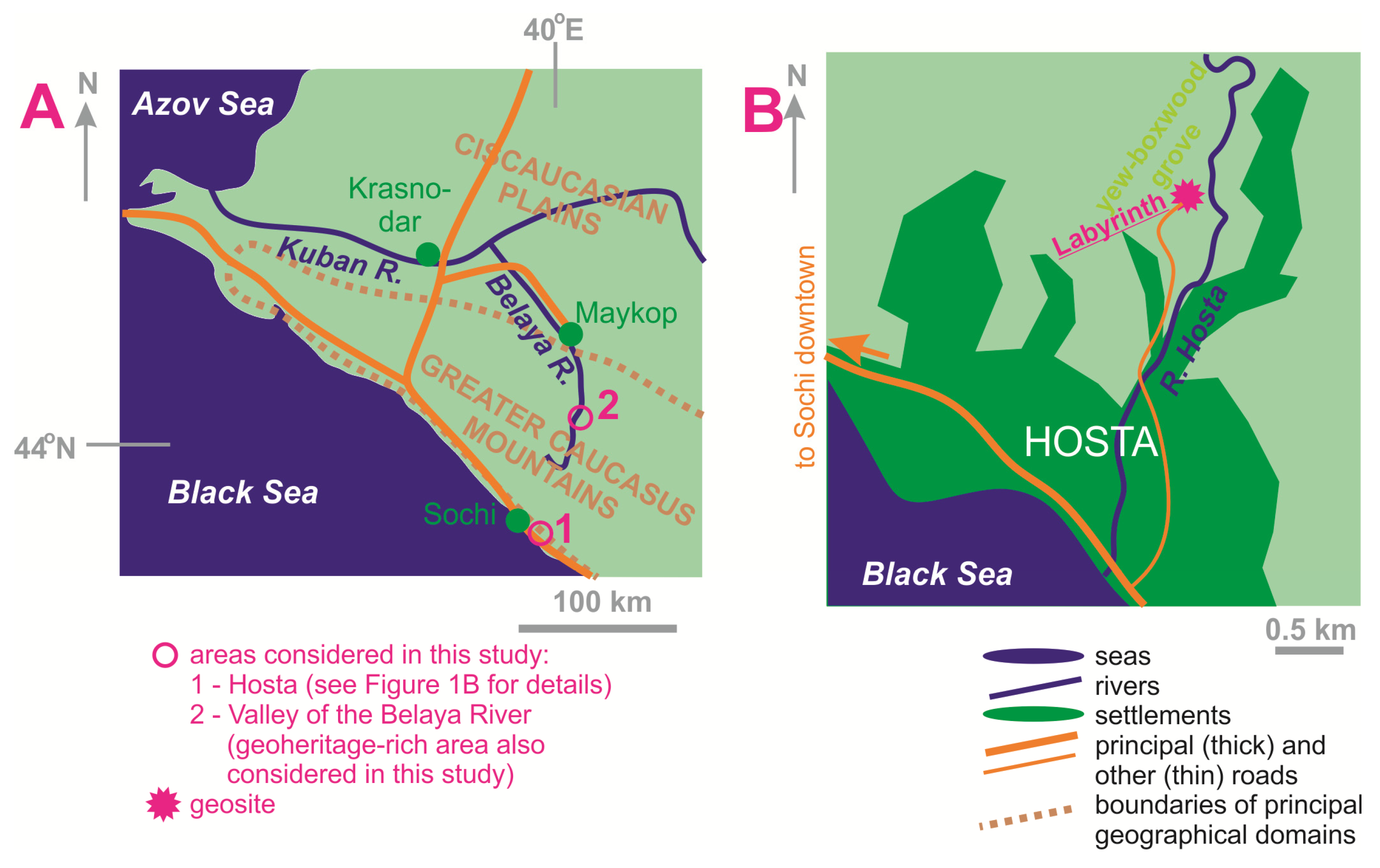
2.1. Study Area

The study area is situated on the northeastern shore of the Black Sea (Figure 1A). Administratively, it belongs to the Krasnodar Region (Kray) of Russia. More precisely, it corresponds to the settlement of Hosta (also spelled as Khosta), which is a southern district of the city of Sochi with a population of ~20,000 people (Figure 1B). This is a popular tourist destination, with dozens of thousands of visitors annually. This is part of the large summer and winter resort of Sochi [24]. The study area is known for its highly unique, subtropical ecosystem of a yew–boxwood grove [25], which is part of the Caucasian State Natural Biosphere Reserve and, in itself, a notable tourist attraction.
Geologically, this area represents the southwestern periphery of the Greater Caucasus, which is a late Cenozoic orogen formed by the Eurasia–Arabian collision [26,27,28]. The vicinities of Hosta are dominated by the Upper Cretaceous–Paleogene deposits (Figure 2A), the lithostratigraphy of which remains debatable [29]. Principally, the Upper Cretaceous deposits are limestones of the Kazachebrodskaya Formation, and the Paleocene–Eocene deposits are marlstones of the Akhshtyrskaya Formation (Figure 2B). They accumulated in the relatively deep, trough-like Greater Caucasus Basin [30]. During the late Cenozoic orogeny, these deposits were distorted to create an elongated fold, namely, the Akhun anticline [31]. The Kazachebrodskaya Formation forms its hinge zone, and the Akhshtyrskaya Formation forms its limbs (Figure 2A).

2.2. Approach

The materials for the present study were collected during a visit to the study area in the summer of 2023. The Hosta’s Labyrinth is a true geosite. It presents particular geological features and forms a separate locality. Moreover, it is exploited as a geosite. The criteria for geosite identification/selection have been developed for a long time. The pioneering works by Wimbledon [32,33] were followed by many other contributions [34,35,36,37,38,39]. Principally, the studied geosite matches the criteria considered in this literature. Moreover, identification/selection procedures depend on national experience and legislation, and the Hosta’s Labyrinth matches the understanding of geosites in Russia. This is why this locality should be assumed as a “ready”, already-existing geosite.
In the field, attention has been paid to the properties of the geosite located in the yew–boxwood grove, as well as to the modes of its exploitation for touristic purposes (Figure 3). The observed properties (see below) reflect the well-visible peculiarities of the geosite, which can be documented objectively. The same is true for its exploitation modes, which are evidenced by well-visible and clear signs. The opinions of visitors and managers are not considered because of two reasons. First, the sample would be too small to undertake any trustable sociological survey (and there may be some technical restrictions for analyzing it). Second, the preliminary observations at this and other geosites imply that visitors and managers may not have a clear enough understanding of the situation and may act rather intuitively.
The analysis is realized in three steps (Figure 3). First, the geological context of the geosite is justified. Particularly, the geosite is described generally and related to what is known about the local geology (Figure 2A). Second, the geosite is described qualitatively (as noted above, its existence does not require additional argumentation). There are many approaches to geosite valuation, which are based on semi-quantitative assessment techniques with scoring using some criteria [40,41,42,43,44,45]. They are suitable in studies of territorial geoheritage when several geosites are considered and require comparison in their overall value; but, the present study focuses on a single geosite. Moreover, the noted approaches do not take into account some properties which cannot be quantified. Nonetheless, the particular properties accounted for in the above-mentioned approaches are considered (Table 1). Each property is checked in the studied geosite, a step which can be carried out objectively, on the basis of field observations of the evident geosite’s peculiarities.
Third, the current touristic exploitation of the Hosta’s Labyrinth is examined. In this study, it is assumed that the given geosite is already being “sold” successfully because it attracts a significant number of visitors. The factors behind this success may or may not be clear to the visitors themselves, but they are objective and can also be established objectively with careful observations and interpretations of how this geosite is designed for geotourists. As a result, the present examination is based on a qualitative analysis of the functionality of the geosite in the study area. This is an attempt to realize what has been accomplished in this geosite to attract visitors’ attention. Indeed, there are direct and easy-to-find signs of relevant geotouristic solutions present in this geosite.

3. Results

3.1. Outline and Properties of the Geosite

The Labyrinth geosite is located in the northern part of the study area (Figure 1B). It is situated in the yew–boxwood grove, i.e., in the territory of the Caucasian State Natural Biosphere Reserve. It presents Upper Cretaceous limestones of the Kazachebrodskaya Formation (Figure 4A), which crop out on the mountain slopes near the valley of the Hosta River. Numerous joints are visible on these limestones (Figure 4B). It appears that the jointing is linked to the late Cenozoic growth of the Greater Caucasus orogen and, particularly, the development of the Akhun anticline. Due to the Quaternary uplift of the area, the Upper Cretaceous rocks became elevated relative to the river valley, as a result of which slope processes initiated. A huge mass (a kind of “tongue”) of limestones separated and started sliding towards the valley under the gravitational force. Hypothetically, this separation occurred along any one weak zone (probably a minor fault). As a result, a narrow furrow inheriting the former weak zone appeared between the parent rocks and the separated mass (Figure 4C). A lengthy trail with stairs leads visitors along this furrow (Figure 4D). The popular, but professional, explanations of the essence and origin of this geosite are given on a special panel (Figure 5A). Generally, the geosite is small in size and looks very ordinary, although peculiar. Nonetheless, this is true geosite because it demonstrates several notable geological features (see above), and it is already being exploited as a geosite for geotouristic purposes.
The properties of the Hosta’s Labyrinth are established in this section on the basis of the field observations conducted. They correspond exactly to how they are explained in Table 1, but are reported below in a slightly different order for a more logical description that starts with an attention to uniqueness (the preferred order reflects the authors’ personal understanding of the optimal way to describe the geosite). The degree of uniqueness of the Labyrinth geosite is low. On the one hand, there are many other outcrops of Upper Cretaceous limestones in the study area, and these rocks themselves are not peculiar. On the other hand, mass wasting is also very common in the study area and beyond. The furrow inheriting the former weak zone or minor fault is unusual, but only locally. However, the low degree of uniqueness does not advise against the attribution of geoheritage to this site because the represented geological phenomena are not common, even if only on the local scale. The content of the geosite demonstrates a moderate diversity. This geosite can be attributed to the engineering type because it represents a process of long-term land sliding. It should be noted that several geosites related to mass wasting have already been reported from different countries [46,47,48,49,50]. Additionally, the limestones of the Kazachebrodskaya Formation constitute a sedimentary type, and the furrow represents both tectonic (a weak zone and a possible minor fault) and geomorphological phenomena (in which case, the geosite is also a geomorphosite sensu [51,52,53,54,55]). The considered geosite has the form of a specific, small-scale natural landform with numerous outcrops. Apparently, the maintenance and permanent use of the trail by tourists have modified it slightly; without them, the bottom of the furrow would be filled with soil and the vegetation would mask some outcrops. This geosite is small in size, but extends for several dozens of meters along the furrow. As such, it has a linear or, better to say, curvilinear configuration (the name of the locality reflects its irregular morphology). Although the Labyrinth geosite represents slope processes, the latter seem too slow to be observed directly (the possible stability of the slope is a subject for further investigations). As a result, this object appears to be more static than dynamic.
The accessibility of the Labyrinth geosite is perfect. The main entrance to the yew–boxwood grove is situated directly on the border of the urban area and ~2 km from its center and principal recreational facilities. It can be accessed by bus, car, or hiking. The Hosta settlement has a well-developed transport infrastructure, and it is connected to the Sochi downtown and other settlements on the Black Sea shore (as well as to central railway stations and an international airport) via a high-class railway and paved roads. Public transportation is also available. The geosite is rather close (a few hundred meters) to the entrance of the yew–boxwood grove, and there is a well-established trail for very comfortable hiking. The only access limitation is the necessity to pay a fee for entering the Caucasian State Natural Biosphere Reserve, although it is cheap for all categories of visitors. The visual examination of the geosite does not reveal any signs of vulnerability, i.e., the locality remains in its natural state. The interpretation need is moderate. Understanding the essence of this geosite is very easy for geology professionals, students, and amateurs. The lay public needs simple clarifications, and these are given professionally on the installed panel (Figure 5A). Any additional scheme explaining the origin of this geosite would strengthen the already-available text interpretation. The Labyrinth geosite seems to be potentially useful for researchers of the local geomorphology, engineering geology, and stratigraphy. It can also be employed by university lecturers to communicate basic knowledge of slope processes. As for tourists, the unusual morphology of the furrow can be judged as attractive. It is questionable whether the exposed geological features are of any aesthetic value, but the attractiveness of the general landscape scenery of the grove seems to be significant (Figure 5B,C). One should note that the beauty of tourist attractions is a highly complex issue which has many aspects and depends on the individual aesthetic preferences of visitors [56]. This is why any aesthetic judgments of the Hosta’s Labyrinth and its landscape context can only be preliminary.

3.2. Exploitation Modes of the Geosite

The yew–boxwood grove of the Caucasian State Natural Biosphere Reserve is visited by dozens of thousands of tourists annually, with increased flows during the summer and the holidays (in winter, the weather is usually mild and does not limit visits to the grove). A significant portion of tourists visit the Labyrinth geosite. A quick analysis of Internet-resources proves the lay public’s interest in visiting this locality, as one can deduce from the number of comments and photographs. It is undisputable that this geosite is exploited very actively for the purpose of tourism. A comparison with the majority of geosites (many of which are potentially more valuable and interesting to tourists) in the Mountainous Adygeya area, which is the other important tourist destination in western Greater Caucasus (Figure 1A), shows that the touristic use of the Labyrinth geosite is significantly more intense. Importantly, the Labyrinth geosite is visited as a geological attraction, not because of any non-geological attributes as in many other cases. Such a successful use of this geosite seems to be unusual, taking into account its small size and very low degree of uniqueness.
Three direct factors in the successful touristic exploitation of the Labyrinth geosite can be specified and are named provisionally as story, route, and cultural appeal. The first of them, story, indicates that a clear, brief, but interesting knowledge of the site has been formulated and communicated in a popular form. This is not the only description of the geosite, but is a true story which informs visitors about something that has happened in this place. Particularly, in the story of the geosite, it is explained that the growth of the Greater Caucasus caused faulting, which determined the development of the landslide. The story is formulated briefly and in a popular form, and it is presented on a special, well-visible panel (Figure 5A). The route factor involves the inclusion of this geosite into the program of an officially recommended excursion in the yew–boxwood grove of the Caucasian State Natural Biosphere Reserve. Visitors follow several, well-established trails (Figure 5B), one of which (probably the most popular) leads them through the geosite (Figure 4C,D). The Labyrinth geosite is one of several attractions (chiefly ecological—Figure 5C) recommended for visiting. The route which includes this geosite is actively promoted in the reserve, both offline and online. The factor of cultural appeal denotes the fact that the lay public is attracted to this geosite because of its analogy to cultural objects. Although the furrow is fully natural, it looks like a man-made labyrinth and is named accordingly. It is known that geoheritage and cultural heritage values are mutually important [16,48,57,58]. The labyrinth is a popular cultural symbol [59] and, thus, mentioning it in the geosite’s name can stimulate the interest of the lay public, despite the risk of misinterpretation of the geosite’s origin.
There are also two other factors that are not related directly to the geosite. First, the study area is part of the very popular beach resort of Sochi, which hosts millions of visitors each summer. So, the large tourist flows make even the smallest attraction in this area demanded. Second, the yew–boxwood grove in the Caucasian State Natural Biosphere Reserve is actively and very professionally promoted (also on the Internet) as one of the most important environmental attractions of Hosta and even of the entire Black Sea shore. This increases the number of visitors to the geosite. It would be wrong to judge these two indirect factors as being more important than the three direct factors, because the latter determine the interest of visitors of the yew–boxwood grove in this geosite. Nonetheless, the touristic exploitation of the Hosta’s Labyrinth shares both active (special attention to the geosite) and passive (attention to the geosite as the only part of a larger attraction) patterns.

4. Discussion

4.1. Broader Meaning of the Proposed Factors of Success

The three direct factors in the exploitation of the Labyrinth geosite seem to be the successful but rather intuitive solutions of the managers of the Caucasian State Natural Biosphere Reserve. As such, the presence of these factors in other places should be checked, and the related published information could be gathered using major bibliographical databases such as “Scopus”. The importance of storytelling in geotourism has been noted in Australia [60], Brazil [61], Canada [62], France [46], and Spain [63]. The inclusion of geosites into complex routes connecting both geological and non-geological attractions is a common practice around the world [64,65,66]. As for cultural appeal, there are lines of evidence from Iran [67] and Romania [68] about the successfulness of the use of popular cultural ideas in geotourism. It should be noted that some geosites representing labyrinth-looking features [69] and landslides [50,70], as well as some large geosites with inner trails showing complex configuration [71], have already been regarded as important in geotourism. The literary information provided above proves that the three established factors are not restricted to the studied geosite in question.
Apparently, the three established factors can be effective in both large, well-known geosites and small localities of local importance. However, these factors depend strongly on the professionalism and creativity of managers. The managers should understand well the geological aspects of the geosite, be aware of its possible cultural interpretations, and have enough skills to develop optimal solutions for its geotouristic exploitation. Apparently, each given geosite requires non-standard ideas for its successful “selling” to the lay public. Indeed, the small size and low degree of uniqueness of some objects may distract managerial attention away from them. The above-given interpretations challenge the current approaches to the evaluation of territorial geotouristic potential. As implied by the case of the Labyrinth geosite, the degree of uniqueness and, thus, overall value of geosites may not matter, because their deficiencies could be compensated via managerial solutions. And, even if some good solutions are found intuitively, the related experience should be documented and reported in the scientific literature to accumulate practical knowledge which can be demanded by geotourism managers.

4.2. Testing Factor Availability in Another Area

The factors of the geotouristic exploitation of the geosite established in the study area and proven using literary evidence from other countries seem to be important. However, this does not mean that the related solutions should be adopted for the successful “selling” of geosites in other areas. On the one hand, there may be situations when such factors principally cannot work. On the other hand, there may be other helpful factors. To demonstrate these options, another area in the same region can be considered. This is the Mountainous Adygeya area, which is also located in the western part of Greater Caucasus, although on the opposite, northern slope of this mountain chain (Figure 1A). This is a famous geodiversity hotspot and tourist destination. Particularly, it is known for its diversity of geomorphological phenomena, numerous sections of Mesozoic sedimentary rocks, and Proterozoic and Paleozoic crystalline complexes.
In the Mountainous Adygeya area, the Belaya River crosses, almost perpendicularly, several mountain ranges of Western Caucasus, and, thus, forms many scientifically important and spectacular outcrops and landforms. A high-class, paved road stretches along the valley of this river and serves as the main channel for tourist flows. It appears logical to create a geotouristic excursion between the Khadzhokh canyon in the north and the Granite gorge in the south. The three suitable localities, which can be clear to the lay public with a minimal or even absent geological background, include the Rufabgo potholes (Figure 6A), the Gud mountain panorama (Figure 6B), and the Lipovy contact (Figure 6C,D). Potentially interesting stories can be proposed for each of them (Table 2). A route can link all the three localities. However, the Rufabgo potholes are found at the toe of the tall and steep slope, and, thus, direct access to them is limited. Principally, they can be observed from a private bridge, leading to very popular waterfalls, but it is unreasonable to pay the entrance fee required if a tourist does not intend to visit these waterfalls (alternatively, the excursion becomes too long and unbalanced). As for the cultural appeal factor, it may apply only in the case of the potholes, which look artificial to many non-professionals.
Out of the three direct factors previously discussed, only one can act fully in the Belaya River valley, which limits its geotouristic potential (see above). Nonetheless, some other factors, absent in the Hosta area, can be proposed. One of them is geoproducts. Contemporary research has paid significant attention to the links between geoheritage and local products, including foods [86,87,88,89,90]. Locally produced cheese, jams, and sweets are sold in many places in the Mountainous Adygeya area. Some of them are true geofood, because they are offered as products of the local mountainous environment (Figure 7). The concentration of vendors attracts many tourists, and even a few vending facilities serve as “magnets” for visitors. Indeed, placing such “magnets” close to geotouristic attractions can stimulate visits to the latter, and this factor can recompensate the absence of other factors. Moreover, selling geofood at geosites can contribute to the sustainable component of geotourism, which is very important [7,91,92,93,94]. For instance, geofood such as the pastila is healthy (there is enough literature about the benefits of eating dried fruits [95,96,97,98,99]), and its consumption cultivates a healthy lifestyle. Moreover, some types of geofood can be made from the “excessive harvest” of fruits, nuts, vegetables, mushrooms, etc., important products which would otherwise be lost as food waste. A problem is that vendors sometimes mix local and non-local (“non-native”) products, which affects the true and perceived authenticity of the local geoheritage landscape.
Generally, it appears that there are various factors to the successful touristic exploitation of geosites, the combinations of which may differ significantly between areas. For instance, geoproducts may or may not be available locally, and their essence, their attractiveness to visitors, and the readiness of local vendors to offer them differ substantially and depend on many additional conditions.

5. Conclusions

The present study has allowed us to characterize the Hosta’s Labyrinth geosite on the northeastern Black Sea shore and seems to be one of the first (if not the first) geoheritage descriptions from the area. The urgency of such studies is dictated by the demand of a quickly growing tourism and recreation industry, which needs new tourist attractions and a diversification of tourists’ experiences. Three main conclusions can be made from this study. First, the Labyrinth geosite is ranked locally, but it is perfectly accessible. Second, this geosite is already being exploited intensively for the purpose of tourism, a matter which has been made possible thanks to three factors (story, route, and cultural appeal) indicating managerial creativity. Third, some important factors in the successful touristic exploitation of geosites do not exist across all existing geosites. Additionally, it should be noted that not only tangible (exposed geological features) but also intangible elements of geoheritage landscapes (e.g., cultural frames for judgment of geological features or local food traditions) can act as important factors in the successful touristic exploitation of a geosite. Generally, it appears that geotouristic developments require further attention to innovative thinking in this sphere and a “deep penetration” into the cultural re-thinking of geosites. The potential of contemporary creative industries can be used for this purpose.
The present study focuses on a notable, but single, example of a case in which geosites are “sold” successively to the lay public. Further conceptual developments require analyses of multiple examples from different countries with different cultural and socio-economical contexts. Any comprehensive review of them would be unrealistic considering the present state of the knowledge about the subject and the need for field investigations, and, thus, reports of suitable case examples should be welcomed. Another research perspective is linked to the analysis of the opinions of geotourists and geotourism managers. However, such studies should be carried out with serious caution because many unexperienced visitors have very limited knowledge of geology and geoheritage and some managerial solutions are only intuitive.

Author Contributions

Conceptualization, V.A.E. and D.A.R.; methodology, D.A.R.; investigation, N.N.Y. and D.A.R.; writing—original draft preparation, N.N.Y., V.A.E. and D.A.R.; project administration, N.N.Y. All authors have read and agreed to the published version of the manuscript.

Funding

This research received no external funding.

Data Availability Statement

No new data were created.

Acknowledgments

The authors thank gratefully the journal’s academic editor and all four reviewers for their thorough consideration of our work and helpful recommendations.

Conflicts of Interest

The authors declare no conflict of interest.

References

  1. Brocx, M.; Semeniuk, V. Geoheritage and geoconservation—History, definition, scope and scale. J. R. Soc. West. Aust. 2007, 90, 53–87. [Google Scholar]
  2. Gray, M. Geodiversity, geoheritage and geoconservation for society. Int. J. Geoherit. Parks 2019, 7, 226–236. [Google Scholar] [CrossRef]
  3. Henriques, M.H.; dos Reis, R.P.; Brilha, J.; Mota, T. Geoconservation as an emerging geosciences. Geoheritage 2011, 3, 117–128. [Google Scholar] [CrossRef]
  4. Pescatore, E.; Bentivenga, M.; Giano, S.I. Geoheritage and Geoconservation: Some Remarks and Considerations. Sustainability 2023, 15, 5823. [Google Scholar] [CrossRef]
  5. Prosser, C.; Murphy, M.; Larwood, J. Geological Conservation: A Guide to Good Practice; English Nature: Peterborough, UK, 2006. [Google Scholar]
  6. Quesada-Valverde, M.E.; Quesada-Román, A. Worldwide Trends in Methods and Resources Promoting Geoconservation, Geotourism, and Geoheritage. Geosciences 2023, 13, 39. [Google Scholar] [CrossRef]
  7. Bentivenga, M.; Cavalcante, F.; Mastronuzzi, G.; Palladino, G.; Prosser, G. Geoheritage: The Foundation for Sustainable Geotourism. Geoheritage 2019, 11, 1367–1369. [Google Scholar] [CrossRef]
  8. Bétard, F.; Hobléa, F.; Portal, C. Geoheritage as new territorial resource for local development. In Annales de Geographie; Armand Colin: Paris, France, 2017; Volume 717, pp. 523–543. [Google Scholar]
  9. Santangelo, N.; Valente, E. Geoheritage and Geotourism resources. Resources 2020, 9, 80. [Google Scholar] [CrossRef]
  10. Dowling, R.; Newsome, D. (Eds.) Handbook of Geotourism; Edward Elgar: Cheltenham, UK, 2018. [Google Scholar]
  11. Farsani, N.T.; Coelho, C.; Costa, C. Geotourism and geoparks as novel strategies for socio-economic development in rural areas. Int. J. Tour. Res. 2011, 13, 68–81. [Google Scholar] [CrossRef]
  12. Ferreira, D.R.; Valdati, J. Geoparks and Sustainable Development: Systematic Review. Geoheritage 2023, 15, 6. [Google Scholar] [CrossRef]
  13. Hose, T.A. 3G’s for Modern Geotourism. Geoheritage 2012, 4, 7–24. [Google Scholar] [CrossRef]
  14. Matshusa, K.; Leonard, L.; Thomas, P. The Contribution of Geotourism to Social Sustainability: Missed Opportunity? Int. J. Sustain. Econ. Soc. Cult. Context 2021, 17, 95–118. [Google Scholar] [CrossRef]
  15. Obradović, S.; Stojanović, V.; Lukić, T. Geotourism and Local Communities: Measuring Residents’ Attitudes Toward Sustainable Tourism in the Fruška Gora National Park. Geoheritage 2023, 15, 90. [Google Scholar] [CrossRef]
  16. Pescatore, E.; Bentivenga, M.; Giano, S.I.; Siervo, V. Geomorphosites: Versatile Tools in Geoheritage Cultural Dissemination. Geoheritage 2019, 11, 1583–1601. [Google Scholar] [CrossRef]
  17. Zhu, Y.; Pang, X.; Zhou, C.; He, X. Coupling Coordination Degree between the Socioeconomic and Eco-Environmental Benefits of Koktokay Global Geopark in China. Int. J. Environ. Res. Public Health 2022, 19, 8498. [Google Scholar] [CrossRef]
  18. Amaro, S.; Chaves, N.B.; Henriques, C.; Barroco, C. Motivation-Based Segmentation of Visitors to a UNESCO Global Geopark. Geoheritage 2023, 15, 79. [Google Scholar] [CrossRef]
  19. Chaves, N.; Amaro, S.; Barroco, C. Visitor’s motivations to the Arouca Geopark. J. Tour. Dev. 2023, 40, 127–136. [Google Scholar]
  20. Drápela, E.; Boháč, A.; Böhm, H.; Zágoršek, K. Motivation and preferences of visitors in the Bohemian Paradise UNESCO Global Geopark. Geosciences 2021, 11, 116. [Google Scholar] [CrossRef]
  21. Kubalíková, L.; Bajer, A.; Balková, M. Brief notes on geodiversity and geoheritage perception by the lay public. Geosciences 2021, 11, 54. [Google Scholar] [CrossRef]
  22. Rodrigues, F.H.; Pereira, D.M.Í.; Kolya, A.A.; Zaine, J.E. Evaluation of the geotourism potential of the northern region of São Sebastião island (São Paulo, Brazil). Anu. Inst. Geocienc. 2020, 43, 255–265. [Google Scholar] [CrossRef]
  23. Štrba, Ľ.; Vravcová, A.; Podoláková, M.; Varcholová, L.; Kršák, B. Linking Geoheritage or Geosite Assessment Results with Geotourism Potential and Development: A Literature Review. Sustainability 2023, 15, 9539. [Google Scholar] [CrossRef]
  24. Markaryan, I.N. Historical way of Sochi development: From resort to Olympic Games Host City. Bylye Gody 2014, 32, 206–214. [Google Scholar]
  25. Gorobtsova, O.N.; Chadaeva, V.A.; Pshegusov, R.K.; Gedgafova, F.V.; Uligova, T.S.; Tembotov, R.K. The current state of forest ecosystems in the Khosta Yew-Boxwood Grove. Environ. Monit. Assess. 2023, 195, 183. [Google Scholar] [CrossRef] [PubMed]
  26. Bewick, S.; Parkinson, I.J.; Harris, N.; Adamia, S.; Sadradze, N.; Allen, M.B.; Hammond, S. Quaternary Collision-Zone Magmatism of the Greater Caucasus. J. Petrol. 2022, 63, egac037. [Google Scholar] [CrossRef]
  27. Forte, A.M.; Gutterman, K.R.; van Soest, M.C.; Gallagher, K. Building a Young Mountain Range: Insight into the Growth of the Greater Caucasus Mountains from Detrital Zircon (U-Th)/He Thermochronology and 10Be Erosion Rates. Tectonics 2022, 41, e2021TC006900. [Google Scholar] [CrossRef]
  28. Vincent, S.J.; Somin, M.L.; Carter, A.; Vezzoli, G.; Fox, M.; Vautravers, B. Testing Models of Cenozoic Exhumation in the Western Greater Caucasus. Tectonics 2020, 39, e2018TC005451. [Google Scholar] [CrossRef]
  29. Andreev, V.M. Stratigraphic scheme of the Caucasus Black Sea coast. In Geology and Biodiversity of the Mesozoic–Cenozoic Deposits of the Russian South; Pinchuk, T.N., Ed.; Tetis: Goryachiy Klyuch, Russia, 2015; pp. 4–10. (In Russian) [Google Scholar]
  30. Yasamanov, N.A. Landscape-Climatic Conditions of the Jurassic, the Cretaceous and the Paleogene of the South of the USSR; Nedra: Moscow, Russia, 1978. (In Russian) [Google Scholar]
  31. Karelina, E.V.; Motuzov, I.S.; Markov, V.E.; Panasenko, Y.N.; Zhorzh, N.V.; Nosaeva, O.V. A study of volcanic-sedimentary rocks of the Dzykhra sequence within the Abkhazian zone of the Gargra-Java uplift, Northwestern Caucasus. RUDN J. Eng. Res. 2022, 23, 343–354. (In Russian) [Google Scholar]
  32. Wimbledon, W.A.P. National site selection, a stop on the way to a European Geosite list. Geol. Balc. 1996, 26, 15–27. [Google Scholar]
  33. Wimbledon, W.A.P. Geosites a new conservation initiative. Episodes 1996, 19, 87–88. [Google Scholar] [CrossRef]
  34. Bruschi, V.M.; Cendrero, A. Geosite evaluation; can we measure intangible values? Alp. Mediterr. Quat. 2005, 18, 293–306. [Google Scholar]
  35. Gatley, S.; Parkes, M. The Selection of and Characters of a Geosite—Examples from Ireland. Geoheritage 2018, 10, 157–167. [Google Scholar] [CrossRef]
  36. Neto, K.; Henriques, M.H. Geoheritage of the Príncipe UNESCO World Biosphere Reserve (West Africa): Selected Geosites. Geoheritage 2023, 15, 118. [Google Scholar] [CrossRef]
  37. Mucivuna, V.C.; da Garcia, M.G.M.; Reynard, E. Criteria for Assessing Geological Sites in National Parks: A Study in the Itatiaia National Park, Brazil. Geoheritage 2022, 14, 1. [Google Scholar] [CrossRef]
  38. Semeniuk, T.A. The Hornsby Quarry Geosite, NSW, Australia—A Geoheritage Treasure. Land 2022, 11, 2124. [Google Scholar] [CrossRef]
  39. Vasiljević, Đ.; Began, M.; Vujičić, M.; Hose, T.; Stankov, U. Does geosite interpretation lead to conservation? A case study of the Sićevo Gorge (Serbia). Acta Geogr. Slov. 2021, 61, 7–21. [Google Scholar] [CrossRef]
  40. Brilha, J. Inventory and Quantitative Assessment of Geosites and Geodiversity Sites: A Review. Geoheritage 2016, 8, 119–134. [Google Scholar] [CrossRef]
  41. Fuertes-Gutiérrez, I.; Fernández-Martínez, E. Geosites Inventory in the Leon Province (Northwestern Spain): A Tool to Introduce Geoheritage into Regional Environmental Management. Geoheritage 2020, 2, 57–75. [Google Scholar] [CrossRef]
  42. Kubalíková, L.; Kirchner, K. Geosite and Geomorphosite Assessment as a Tool for Geoconservation and Geotourism Purposes: A Case Study from Vizovická vrchovina Highland (Eastern Part of the Czech Republic). Geoheritage 2016, 8, 5–14. [Google Scholar] [CrossRef]
  43. Štrba, L.; Rybár, P.; Baláž, B.; Molokac, M.; Hvizdak, L.; Krsak, B.; Lukac, M.; Muchova, L.; Tometzová, D.; Ferenčíková, J. Geosite assessments: Comparison of methods and results. Curr. Issues Tour. 2015, 18, 496–510. [Google Scholar] [CrossRef]
  44. Tamang, L.; Mandal, U.K.; Karmakar, M.; Banerjee, M.; Ghosh, D. Geomorphosite evaluation for geotourism development using geosite assessment model (GAM): A study from a Proterozoic terrain in eastern India. Int. J. Geoherit. Parks 2023, 11, 82–99. [Google Scholar] [CrossRef]
  45. Zafeiropoulos, G.; Drinia, H. GEOAM: A Holistic Assessment Tool for Unveiling the Geoeducational Potential of Geosites. Geosciences 2023, 13, 210. [Google Scholar] [CrossRef]
  46. Desbois, J.-L.; Costabloz, V. Garins’ landslide: From a geohazard to a touristic and pedagogical geosite. Rend. Online Soc. Geol. Ital. 2013, 28, 41–44. [Google Scholar]
  47. Morino, C.; Coratza, P.; Soldati, M. Landslides, a Key Landform in the Global Geological Heritage. Front. Earth Sci. 2022, 10, 864760. [Google Scholar] [CrossRef]
  48. Niculiţă, M.; Mărgărint, M.C. Landslides and Fortified Settlements as Valuable Cultural Geomorphosites and Geoheritage Sites in the Moldavian Plateau, North-Eastern Romania. Geoheritage 2018, 10, 613–634. [Google Scholar] [CrossRef]
  49. Senese, A.; Pelfini, M.; Maragno, D.; Bollati, I.M.; Fugazza, D.; Vaghi, L.; Federici, M.; Grimaldi, L.; Belotti, P.; Lauri, P.; et al. The Role of E-Bike in Discovering Geodiversity and Geoheritage. Sustainability 2023, 15, 4979. [Google Scholar] [CrossRef]
  50. Tronti, G.; Vergari, F.; Bollati, I.M.; Belisario, F.; Del Monte, M.; Pelfini, M.; Fredi, P. From landslide characterization to nature reserve management: The “Scialimata Grande di Torre Alfina” landslide Geosite (Central Apennines, Italy). J. Mt. Sci. 2023, 20, 585–606. [Google Scholar] [CrossRef]
  51. Erhartič, B. Geomorphosite assessment. Acta Geogr. Slov. 2010, 50, 295–319. [Google Scholar] [CrossRef]
  52. Panizza, M. Geomorphosites: Concepts, methods and examples of geomorphological survey. Chin. Sci. Bull. 2001, 46, 4–6. [Google Scholar] [CrossRef]
  53. Pereira, P.; Pereira, D. Methodological guidelines for geomorphosite assessment. Geomorphol. Relief Process. Environ. 2010, 2, 215–222. [Google Scholar] [CrossRef]
  54. Reynard, E.; Coratza, P. Geomorphosites and geodiversity: A new domain of research. Geogr. Helv. 2007, 62, 138–139. [Google Scholar] [CrossRef]
  55. Santos, D.S.; Mansur, K.L.; Seoane, J.C.S.; Mucivuna, V.C.; Reynard, E. Methodological Proposal for the Inventory and Assessment of Geomorphosites: An Integrated Approach focused on Territorial Management and Geoconservation. Environ. Manag. 2020, 66, 476–497. [Google Scholar] [CrossRef]
  56. Kirillova, K.; Fu, X.; Lehto, X.; Cai, L. What makes a destination beautiful? Dimensions of tourist aesthetic judgment. Tour. Manag. 2014, 42, 282–293. [Google Scholar] [CrossRef]
  57. Gordon, J.E. Geoheritage, geotourism and the cultural landscape: Enhancing the visitor experience and promoting geoconservation. Geosciences 2018, 8, 136. [Google Scholar] [CrossRef]
  58. Pijet-Migoń, E.; Migoń, P. Geoheritage and Cultural Heritage—A Review of Recurrent and Interlinked Themes. Geosciences 2022, 12, 98. [Google Scholar] [CrossRef]
  59. Montecchi, B. The labyrinth: Building, myth, and symbol. Aegaeum 2016, 39, 165–174. [Google Scholar]
  60. Lewis, I.D. Evolution of Geotourism in Australia from Kanawinka Global Geopark and Australian National Landscapes to GeoRegions and Geotrails: A Review and Lessons Learned. Land 2023, 12, 1190. [Google Scholar] [CrossRef]
  61. De Arruda, Í.R.P.; De Lima, G.R.; Da Silva Listo, D.G.; Mariano, G.; De Oliveira Guimarães, T. Proposal for Geoconservation in the district of Fazenda Nova—Brejo da Madre de Deus—Pernambuco, Northeast Brazil. Geol. USP—Ser. Cient. 2023, 23, 87–98. [Google Scholar]
  62. Miller, R.F.; Buhay, D.N. Turning a Forgotten Geological Heritage into a Geological Park: Developing Stonehammer Geopark. Geoheritage 2014, 6, 29–39. [Google Scholar] [CrossRef]
  63. Pardo-Igúzquiza, E.; Durán-Valsero, J.J.; Dowd, P.A.; Luque-Espinar, J.A.; Heredia, J.; Robledo-Ardila, P.A. Geodiversity of closed depressions in a high relief karst: Geoeducation asset and geotourism resource in the “Sierra de las Nieves” National Park (Málaga Province, Southern Spain). Int. J. Geoherit. Parks 2022, 10, 196–217. [Google Scholar] [CrossRef]
  64. Çiftçi, Y.; Güngör, Y. Natural and cultural heritage integration and geoconservation recommendatory of the Nemrut—Süphan proposed geopark area, Bitlis—Turkey. Bull. Miner. Res. Explor. 2021, 165, 191–215. [Google Scholar] [CrossRef]
  65. Herrera-Franco, G.; Mora-Frank, C.; Kovács, T.; Berrezueta, E. Georoutes as a Basis for Territorial Development of the Pacific Coast of South America: A Case Study. Geoheritage 2022, 14, 78. [Google Scholar] [CrossRef]
  66. Wulung, S.R.P.; Yuliawati, A.K.; Abdullah, C.U.; Fitriyani, E. Spice cultural heritage in geotourism trail. J. Eng. Sci. Technol. 2022, 17, 76–87. [Google Scholar]
  67. Khoshraftar, R.; Torabi Farsani, N. Geomythology: An Approach for Attracting Geotourists (Case Study: Takht-e Soleymān—Takab World Heritage Sites). Geoheritage 2019, 11, 1879–1888. [Google Scholar] [CrossRef]
  68. Necheş, I.-M. From geomorphosite evaluation to geotourism interpretation. Case study: The Sphinx of Romania’s Southern Carpathians. Geoj. Tour. Geosites 2013, 12, 145–162. [Google Scholar]
  69. Singtuen, V.; Junjuer, T. Characterisation of potholes formed on bedrock sandstones at Loei Dun, Phetchabun Geopark, Thailand. Geologos 2022, 28, 39–50. [Google Scholar] [CrossRef]
  70. Keskin Citiroglu, H.; Isik, S.; Pulat, O. Utilizing the Geological Diversity for Sustainable Regional Development, a Case Study-Zonguldak (NW Turkey). Geoheritage 2017, 9, 211–223. [Google Scholar] [CrossRef]
  71. Masseroli, A.; Bollati, I.M.; Fracasetti, L.; Trombino, L. Soil Trail as a Tool to Promote Cultural and Geoheritage: The Case Study of Mount Cusna Geosite (Northern Italian Apennines). Appl. Sci. 2023, 13, 6420. [Google Scholar] [CrossRef]
  72. Dhali, M.K. Dynamic evolution of riverbed potholes in the granitic bedrock of Chota Nagpur Plateau, middle part of Subarnarekha River basin, India. J. Hydrol. 2019, 571, 819–836. [Google Scholar] [CrossRef]
  73. Huang, R.; Tang, D.; Li, Q.; Li, Q.; Zhou, M.; Feng, M.; Li, T.; Liu, L. Formation mechanism of volcanic tuff river potholes in Leizhou Peninsula, Guangdong Province. Quarter. Sci. 2022, 42, 541–551. [Google Scholar]
  74. Lima, A.G.; Binda, A.L. Differential control in the formation of river potholes on basalts of the Paraná Volcanic Province. J. South Am. Earth. Sci. 2015, 59, 86–94. [Google Scholar] [CrossRef]
  75. Nemec, W.; Lorenc, M.W.; Saavedra Alonso, J. Potholed granite terrace in the Rio Salor valley, Western Spain: A study of bedrock erosion by floods. Tecniterrae 1982, 50, 1–16. [Google Scholar]
  76. Ortega-Becerril, J.A.; Garrote, J. Magnitude of formative flows in stream potholes. Geomorph 2023, 434, 108738. [Google Scholar] [CrossRef]
  77. Cundari, A. Inverted relief due to lava flows along valleys. Aust. Geogr. 1970, 11, 291–293. [Google Scholar] [CrossRef]
  78. Karim, K.H.; Khanaqa, P.A. Syncline contribution to mountain peak building: Examples from Western Zagros, Kurdistan Region, Northeastern Iraq. Arab. J. Geosci. 2017, 10, 375. [Google Scholar] [CrossRef]
  79. Pain, C.F.; Ollier, C.D. Inversion of relief—A component of landscape evolution. Geomorphology 1995, 12, 151–165. [Google Scholar] [CrossRef]
  80. van Wyk de Vries, B.; Karatson, D.; Gouard, C.; Nemeth, K.; Rapprich, V.; Aydar, E. Inverted volcanic relief: Its importance in illustrating geological change and its geoheritage potential. Int. J. Geoherit. Parks 2022, 10, 47–83. [Google Scholar] [CrossRef]
  81. Wang, Z.-T.; Lai, Z.-P.; Qu, J.-J. Inverted relief landforms in the Kumtagh Desert of northwestern China: A mechanism to estimate wind erosion rates. Geol. J. 2017, 52, 131–140. [Google Scholar] [CrossRef]
  82. Franke, W.; Cocks, L.R.M.; Torsvik, T.H. The Palaeozoic Variscan oceans revisited. Gondw. Res. 2017, 48, 257–284. [Google Scholar] [CrossRef]
  83. Stampfli, G.M.; Hochard, C.; Vérard, C.; Wilhem, C.; von Raumer, J. The formation of Pangea. Tectonophysics 2013, 593, 1–19. [Google Scholar] [CrossRef]
  84. von Raumer, J.F.; Stampfli, G.M.; Bussy, F. Gondwana-derived microcontinents—The constituents of the Variscan and Alpine collisional orogens. Tectonophysics 2003, 365, 7–22. [Google Scholar] [CrossRef]
  85. Stuwe, K. Geodynamics of the Lithosphere; Springer: Berlin/Heidelberg, Germany, 2007. [Google Scholar]
  86. Cusano, A.; Russo, F.; Guerriero, L.; Colucciello, A.; Ruzza, G.; Guadagno, F.M.; Revellino, P. Geotourism, traditions and typical products of Avellino Province. J. Maps 2022, 18, 133–141. [Google Scholar] [CrossRef]
  87. Komoo, I.; Azman, N.; Ahmad, N.; Ali, C.A.; Bukhari, A.M.M. An Integrated Geoproduct Development for Geotourism in Langkawi UNESCO Global Geopark: A Case Study of the Kubang Badak Biogeotrail. Geoheritage 2022, 14, 37. [Google Scholar] [CrossRef]
  88. Nakonechnykh, V.; Zhuravleva, M.; Sivkova, A.; Volokhova, S. The impact of the territorial marketing on highlighting the brand “Baikal” in the Baikal region. Geoj. Tour. Geosites 2019, 27, 1271–1279. [Google Scholar] [CrossRef]
  89. Rodrigues, J.; Neto de Carvalho, C.; Ramos, M.; Ramos, R.; Vinagre, A.; Vinagre, H. Geoproducts—Innovative development strategies in UNESCO Geoparks: Concept, implementation methodology, and case studies from Naturtejo Global Geopark, Portugal. Int. J. Geoherit. Parks 2021, 9, 108–128. [Google Scholar] [CrossRef]
  90. Yuliawati, A.K.; Rofaida, R.; Gautama, B.P.; Aryanti, A.N. Coffee as geo-product of a small island geopark increasing livelihood in a local community-A study in Belitung Island. Afr. J. Hosp. Tour. Leis. 2019, 2019, 1–6. [Google Scholar]
  91. Frey, M.-L. Geotourism—Examining tools for sustainable development. Geosciences 2021, 11, 30. [Google Scholar] [CrossRef]
  92. Górska-Zabielska, M. A New Geosite as a Contribution to the Sustainable Development of Urban Geotourism in a Tourist Peripheral Region—Central Poland. Resources 2023, 12, 71. [Google Scholar] [CrossRef]
  93. Lazzari, M.; Aloia, A. Geoparks, geoheritage and geotourism: Opportunities and tools in sustainable development of the territory. Geoj. Tour. Geosites 2014, 13, 8–9. [Google Scholar]
  94. Mohamadianmansoor, S.; Khanian, M. Sustainable Geotourism: Developing a Grounded Model for Evaluation of Geoutouristic Capacities in Geosites via the Study of Khorzeneh in Hamedan, Iran. Geoheritage 2022, 14, 26. [Google Scholar] [CrossRef]
  95. Alasalvar, C.; Salvadó, J.-S.; Ros, E. Bioactives and health benefits of nuts and dried fruits. Food Chem. 2020, 314, 126192. [Google Scholar] [CrossRef] [PubMed]
  96. Keast, D.R.; O’Neil, C.E.; Jones, J.M. Dried fruit consumption is associated with improved diet quality and reduced obesity in US adults: National Health and Nutrition Examination Survey, 1999–2004. Nutr. Res. 2011, 31, 460–467. [Google Scholar] [CrossRef] [PubMed]
  97. Shah, A.S.; Bhat, S.V.; Muzaffar, K.; Ibrahim, S.A.; Dar, B.N. Processing Technology, Chemical Composition, Microbial Quality and Health Benefits of Dried Fruits. Curr. Res. Nutr. Food Sci. 2022, 10, 71–84. [Google Scholar] [CrossRef]
  98. Sullivan, V.K.; Na, M.; Proctor, D.N.; Kris-Etherton, P.M.; Petersen, K.S. Consumption of Dried Fruits Is Associated with Greater Intakes of Underconsumed Nutrients, Higher Total Energy Intakes, and Better Diet Quality in US Adults: A Cross-Sectional Analysis of the National Health and Nutrition Examination Survey, 2007–2016. J. Acad. Nutr. Diet. 2021, 121, 1258–1272. [Google Scholar] [CrossRef] [PubMed]
  99. Testa, R.; Rizzo, G.; Schifani, G.; Tinebra, I.; Farina, V.; Vella, F.; Migliore, G. Can Dried Fruits Replace Unhealthy Snacking among Millennials? An Empirical Study on Dried Fruit Consumption in Italy. Sustainability 2023, 15, 7083. [Google Scholar] [CrossRef]
Figure 1. Geographical location of the study area and the Labyrinth geosite: (A) general position in the Western Caucasus and (B) local geographical outline.
Heritage 06 00369 g001
Figure 2. Geological setting of the study area (see [29] for the related sources): (A) simplified geological scheme and (B) composite stratigraphical section.
Heritage 06 00369 g002
Figure 3. Methodological outline of the present study.
Heritage 06 00369 g003
Figure 4. Labyrinth geosite, part one: (A) Upper Cretaceous limestones, (B) joints in the limestones, (C) furrow within the limestone massif, and (D) trail with stairs constructed for hiking within the geosite.
Heritage 06 00369 g004
Figure 5. Labyrinth geosite, part two: (A) panel explaining the geosite’s origin, (B) landscape of the yew–boxwood grove and markers of the ecological path, and (C) notable ecological attraction.
Heritage 06 00369 g005
Figure 6. Localities of the Belaya River valley: (A) Rufabgo potholes carved in the Lower Triassic limestones, (B) isolated Gud mountain (inverted landform), and (C,D) Contact of late Proterozoic Balkan metamorphics representing Gondwana (Gon) and Carboniferous Malka granitoids representing Laurussia (Lau).
Heritage 06 00369 g006
Figure 7. Geoproducts of the Mountainous Adygeya area: pastila (dried jam made from fruits and berries) and dried mushrooms.
Heritage 06 00369 g007
Table 1. Geosite properties considered in the present study and listed in alphabetical order. These properties may differ in their priority (“weight”), but this depends on the views of particular experts and particular situations, and it is not the aim of this case study to enter these debates; moreover, it would be difficult to indicate the priority of some properties which cannot be quantified.
PropertyExplanation (Definitions as Preferred in the Present Study)
AccessibilityOpportunity to reach geosites and move within them; this property often depends on the physical remoteness of the geosites, on the wilderness of the landscape, on the transport infrastructure, on the availability of bus and car stops, and on the within-geosite infrastructure (trails, stairs, etc.).
AestheticsHow geosites can appeal to the visitors’ ideas of beauty; importantly, this property is very relational (different visitors may have very different, and even opposite, ideas of beauty) and is determined by both the geological features and the geosites’ landscape context.
Configuration (geometry)Spatial appearance of geosites: too-small geosites look like points, but large geosites may extend as a line (linear) or embrace some plots (areal); higher-complex forms are also possible.
ContentGeological phenomena represented at geosites, which can be assigned to one or several types.
Degree of uniqueness (rank)Spatial rarity of geosites, which can be unique on the local, regional (provincial), national, and global levels. This property seems to be essential for geosite valuation.
DynamicsGeosites can be static (representing objects) or dynamic (representing processes).
FormNatural outcrop, road cutting, quarry, etc.
Interpretation needsHow difficult understanding the essence of geosites is for visitors with different levels of geological knowledge (which is very elementary or even absent in the majority of visitors).
UsefulnessImportance of geosites to research, teaching, and tourism.
VulnerabilityExposure to any present or potential danger, which can lead to the loss of a geosite’s informativeness, physical damage, or destruction; this property depends on natural (also geological) processes and anthropogenic pressure.
Table 2. Possible storytelling during the Belaya River geoexcursion.
LocalityGeneral Geological KnowledgeStory Elements
Rufabgo potholesPotholes reflect some specific mechanisms of river erosion, the understanding of which remains incomplete and attracts researchers’ attention [72,73,74,75,76]. It appears that potholes are formed commonly on the river bottom (especially during seasonal floods), and the subsequent uplift and related valley incision lead to their full or partial exposure above the water level.Basic elements:
-
Formation of hard rocks
-
Valley incision
-
Floods and erosion
Advanced elements:
-
Idea of pseudokarst
-
Comparison to granitic potholes exposed upstream and differentiated by smoother pothole edges
Gud mountain panoramaDevelopment of inverted landforms reflects notable interaction between geomorphological processes and local geological settings [77,78,79,80,81]. A particular example of this can be seen when active river erosion removes older soft rocks at the limbs of a syncline, whereas the hinge zone remains “protected”, being capped by younger hard rocks. As a result, the most elevated point represents the syncline axis.Basic elements:
-
Not a volcano (Gud is commonly misinterpreted as an ancient volcano)
-
Isolated landform
-
What is on the top?
Advanced elements:
-
Idea of inverted landforms
-
Jurassic stratigraphy
Lipovy contactIn the Paleozoic, there were several episodes of the detachment of terranes from the Tethyan margin of Gondwana; these terranes, which often formed chains (superterranes), moved northward, with the oceans opening to the south of these chains and the other oceans closing to the north of them [82,83,84]. This was a kind of mega-conveyor, which functioned even after the assembly of the Pangaea.Basic elements:
-
Origin of the Greater Caucasus in the deep time
-
“Africa meets Europe”
Advanced elements:
-
Idea of terranes
-
Sharpness of intrusive contact (ideas of [85])
-
Gondwanan metamorphics
-
Laurussian granitoids
Disclaimer/Publisher’s Note: The statements, opinions and data contained in all publications are solely those of the individual author(s) and contributor(s) and not of MDPI and/or the editor(s). MDPI and/or the editor(s) disclaim responsibility for any injury to people or property resulting from any ideas, methods, instructions or products referred to in the content.

