Article

Development of a Scanning Protocol for Anthropological Remains: A Preliminary Study

1
LabDig 3A Academy Association, Albizzate, 21041 Varese, Italy
2
Department of Cultural and Environmental Heritage, University of Milan, 20142 Milan, Italy
3
Department of Biotechnology and Life Sciences, University of Insubria, 21100 Varese, Italy
4
Department of Cultural Heritage, University of Padua, 35139 Padua, Italy
*
Author to whom correspondence should be addressed.
Heritage 2024, 7(9), 4997-5006; https://doi.org/10.3390/heritage7090236
Submission received: 30 June 2024 / Revised: 2 September 2024 / Accepted: 4 September 2024 / Published: 10 September 2024
(This article belongs to the Section Archaeological Heritage)

Abstract

:
Structured-light scanning is a fast and efficient technique for the acquisition of 3D point clouds. However, the extensive and daily application of this class of scanners can be challenging because of the technical know-how necessary to validate the low-cost instrumentation. This challenge is worth accepting because of the large amount of data that can be collected accurately with the aid of specific technical protocols. This work is a preliminary study of the development of an acquisition protocol for anthropological remains performing tests in two opposite and extreme contexts: one characterised by a dark environment and one located in an open area and characterised by a very bright environment. This second context showed the influence of sunlight in the acquisition process, resulting in a colourless point cloud. It is a first step towards the development of a technical protocol for the acquisition of anthropological remains, based on the research of limits and problems associated with an instrument.

1. Introduction

The preliminary work presented in this paper is part of a wider project for the validation of low-cost instrumentation, which can potentially enable the gathering of more data in a faster and more accurate way. The validation process requires the development of technical protocols for both verification and acquisition.
The test, presented as follows, has been performed on a low-cost structured-light scanner, Einstar-Portable Handheld 3D Scanner, as a preliminary step towards its validation. The scanner was chosen according to the available budget and the hardware selection performed by a technician, which falls outside the scope of this paper. The preliminary test was executed at two different locations characterised by borderline environmental conditions to evaluate the performance and begin the development of a technical scanning protocol. The test in borderline conditions is a key point for the validation of instrumentation. The first location was the Funerary Unit 1 from the hypogeal cemetery of the Church of Santa Maria Maggiore in Vercelli (Piedmont, northern Italy), characterised by high darkness. The second was tomb Tb10 in the open-area site of “Rocca di Monselice” (Veneto, northern Italy), where sunlight and rocks delineate an environment marked by extreme light.
Bibliographic research was performed on multidisciplinary and comprehensive databases. Few articles relate to the use of low-cost structured-light scanners, and they mostly compare different acquisition techniques. None of them provide a detailed acquisition protocol. Moreover, works relating to the application of structured-light scanning are quickly outdated due to the constantly increasing development of new technologies and solutions. The reviewed publications cover the use of different sensors for 3D acquisition in different fields: anthropology, archaeology, precision engineering, applied sciences, remote sensing, metrology, and manufacturing. The acquisition can involve many classes of material: cuneiform tablets [1], statues [2,3,4], bone cut marks [5], small artifacts [6], fossils [7,8,9], or different classes of artifacts [10,11]. The techniques used include photogrammetry [2,3,4,6,11], laser scanning [3,6,7,9], and structured-light scanning [1,2,4,5,6,7,8,9,10,11]. For structured-light scanning, high-cost scanners [1,4,7,8,9,11] or entry-level to mid-priced scanners with technical characteristics are generally not suitable for our case [2,5,6,7].
Many are not suitable for large-scale applications and daily use mostly because of their high cost: one of the scanners used in the papers above, as an example, costs EUR 7370.00 in June 2024, whereas the project intends to develop technical protocols for instrumentation costing less than EUR 3000. On the other side, there are low-cost structured-light scanners, such as the Einstar-Portable Handheld 3D Scanner (cost: EUR 1170.00 [12]), which are a more economical option but require specific know-how for the definition of appropriate configuration and technical protocols due to the absence of technical support specific for this context of the application, namely Cultural Heritage.
Menna and colleagues [7] underline the need for a strong awareness of the technical and critical steps of 3D acquisition, as well as the necessity of correct planning, because “redundancy, real-time pre-processing as well as onsite verifications and checklists are some of the tasks to be accomplished by the digitization team, usually under time pressure”. It is significant also to note that Williams and colleagues [13] report the limited “guidance and recommendations for 3D scanning procedures […], resulting in the absence of standardisation across 3D specialists, professionals and beginners” in archaeology.
Other works propose mathematical methods for the correction of errors and distortion induced by structured-light scanners. Dickin and colleagues [14] propose a correction mechanism based on the comparison with a CMM (coordinate measuring machine) measurement, involving a least square solution via nonlinear minimization. Differently, Colosimo and colleagues [15] use points obtained with a CMM as local attractors to reduce the local bias of the high-density dataset obtained with a structured-light scanner. These methods involve the use of a higher-accuracy measurement system to validate and correct the structured-light scanning. Cost and practical issues do not permit the application of these methods in ordinary field work acquisition.
A systematic reproducibility and repeatability analysis on a specific scanner was performed by Jacobs and colleagues [16]. Different angles and different numbers of positions were tested, assessing the scanner’s performance relative to a standard object. The author presents an analysis of a desktop structured-light scanner, which is not similar to the case of the Einstar-Portable Handheld 3D scanner. However, it will be a good starting point for developing specific tests for the handheld scanner used in this work.
Gupta and colleagues [17] propose a method for the reduction in the effect of ambient light illumination through a combination of optical suppression and the optimal distribution of the light in order to maximize SNR (signal-to-noise ratio).
Publications regarding anthropology and paleoanthropology generally involve applications in GM (geometric morphometrics) in a digital environment [18,19], which is the subsequent step with respect to our work.
In conclusion, very few works have been written on the validation and verification of low-cost structured-light scanning systems and the development of technical protocols for standardized use. Less was achieved in field tests. Practically no studies were carried out for the verification and application of these systems in the context of anthropology, with the aim of providing a framework for extensive application. The aim of the project is to begin to fill this gap, and this work is an initial step in this direction.

2. Materials and Methods

The Einstar-Portable Handheld 3D Scanner (Figure 1) with the software ExStar 1.2.1.0.rc was chosen to perform the acquisition of burials. This scanner was selected because, according to the manufacturer, the scanning resolution is invariant with respect to the working distance and the orientation inside the specified range.
Points are located on a regular grid with a distance specified by the operator. Point distance can be set within a range between 0.1 and 3 mm. For our test, a point distance of 0.5 mm was set. This is the limit value for the processing with the hardware of the workstation we used for these tests. The modality used is “Object scan” with alignment mode “Hybrid alignment (feature + texture)”. With this configuration, the depth of field and the working distance are in a range between 160 mm and 600 mm, with an optimal working distance of 400 mm. If the point distance is not compatible with the working range, a warning is prompted by the software. The same occurs if, during scanning, the distance falls outside the established range. In the test, a working distance between 160 and 400 mm was set. The maximum value was determined via practical considerations because of the physical difficulties in reaching a higher distance at the top surface of the grave.
A data quality indicator serves as an estimation of data refinement. It colours the features in real time during the scanning according to this parameter. Red colour indicates low quality, and green indicates high quality. A warning is prompted by the software if the alignment is missed. Measurement accuracy can be improved by passing the scanner on the surfaces of interest several times until the desired data quality is reached. The scanning test had the goal of obtaining high-quality data with respect to the software data quality indicator.
The projector is based on infrared VCSEL technology. The scanner is equipped with an RGB camera in order to capture texture and colour. The temperature range is 0°–40°, and the humidity needs to lie between 10% and 90%.
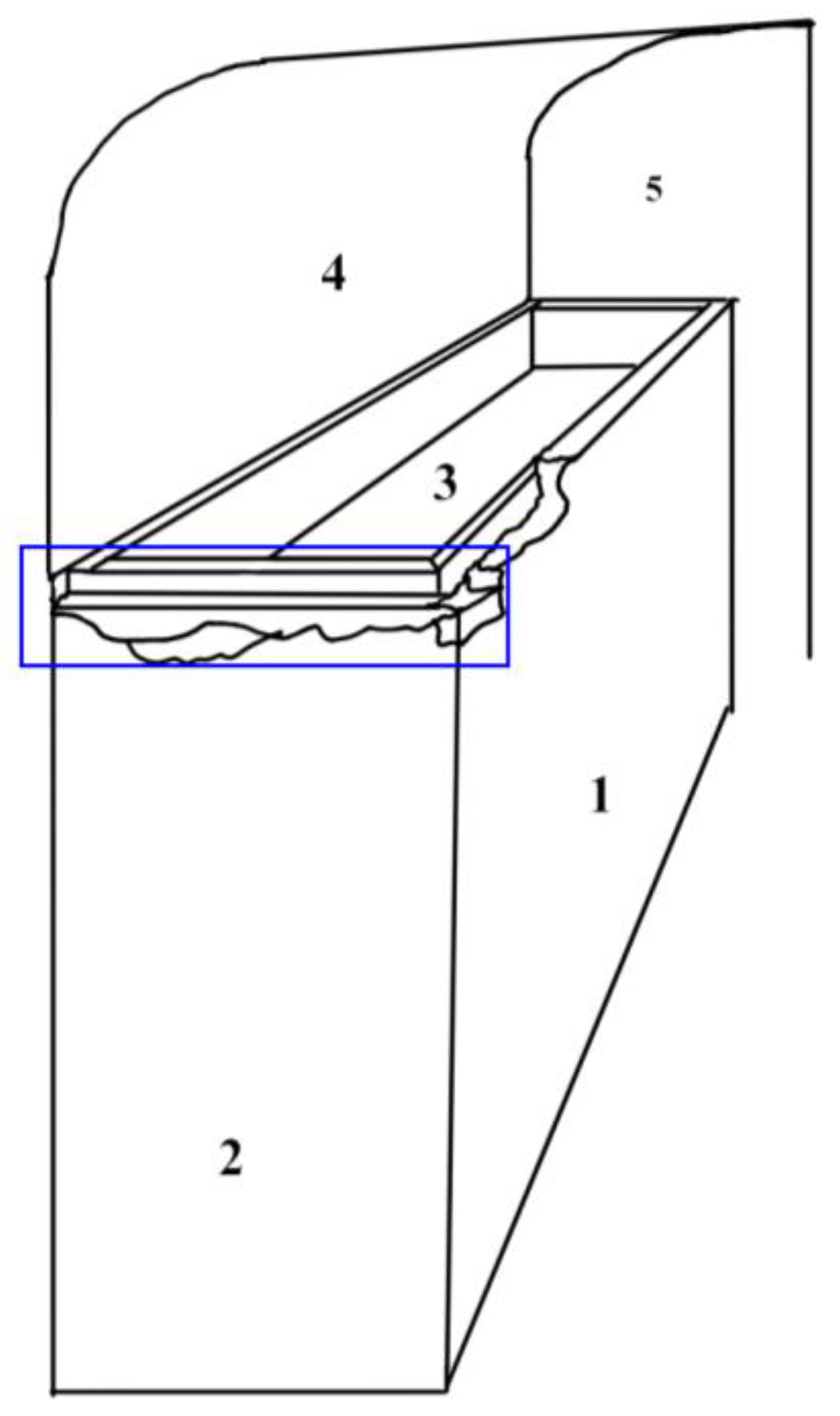
The survey was not performed along different profiles parallel to each other over each acquisition plane as far as it was not necessary according to technical specifications. The acquisition technique consisted of a preliminary evaluation of the structure in order to identify the theoretical acquisition plans, which are visible in Scheme 1. Scanning starts from an arbitrarily chosen plane defined as plane 1 in the scheme. The joint between plane 1 and plane 2 was possible because of the more rounded angle in the blue area, which forms a connecting surface for planes 1, 2, and 3. The acquisition continues with planes 3 and 4, which are located in the internal structure where the mummy is collocated. After a first alignment, the datum is refined by passing the scanner on the surfaces of interest several times and changing the orientation and inclination of the scanner. This operation allows one to reach hidden points when a complex surface is scanned.
In the case of the Tb 10 from Monselice, only one theoretical acquisition plane was identified.
The minimal requirements for the Einstar scanner are as follows: CPU Intel® Core™ i7-11800H or above, graphics card NVIDIA GTX 1060 or above, graphics memory 6GB or above, RAM 32GB or above, and serial connector USB 2.0 or above. For processing, ASUS ProArt (Asus W7604J3D-MY021X) was used, with an Intel Core i9-13980HX Processor 2.2 GHz (36MB Cache, up to 5.6 GHz, 24 cores, 32 Threads) as a CPU; the graphic card was NVIDIA RTX™ A3000 Laptop GPU 8GB, and a 2TB M.2 NVMe PCIe 4.0 Performance SSD was used for storage. The operating system is Windows 11, and a 2TB M.2 NVMe PCIe 4.0 Performance SSD was used for storage. The serial connector is USB 3.1.
The contexts were chosen because of the extremely different light conditions. The illumination of the two areas was not measured. A quantitative study will be performed in a more advanced stage of the research.

The Contexts

The Church of Santa Maria Maggiore in Vercelli was built by the Jesuits in the 18th century to replace the old church Santissima Trinità. In 1780, the church was named after the old basilica that stood just a few meters away [20].
The current Santa Maria Maggiore houses a unique burial space in its underground area, constructed in tandem with the upper church. The space is organized with vaulted structures that partly reuse fragments of previous buildings on the site. This space is home to two large ossuaries and a series of collateral rooms used for funerary purposes, where many bones can still be observed today. These bones, grouped in various ways, are likely from the burials removed from the nearby complex that was being demolished. This vast cemetery, closely connected with the previous episcopal church, became a new burial area used until the early decades of the 19th century by ecclesiastics and members of the Vercelli nobility. The cemetery, therefore, provides a unique opportunity to analyze different types of human body preservation related to burial practices and the general burial context.
In September 2020, the anthropology division of the University of Insubria embarked on a meticulous process of recovering bioarchaeological evidence from the hypogeum cemetery. The cemetery was methodically divided into sectors I to V, and each tomb structure, known as a funerary unit (FU), was assigned a number from 1 to 19. Inside the different rooms in sectors I, II, and III, mummified bodies were found in masonry tombs, some of which had been opened due to incursions and vandalism over the years.
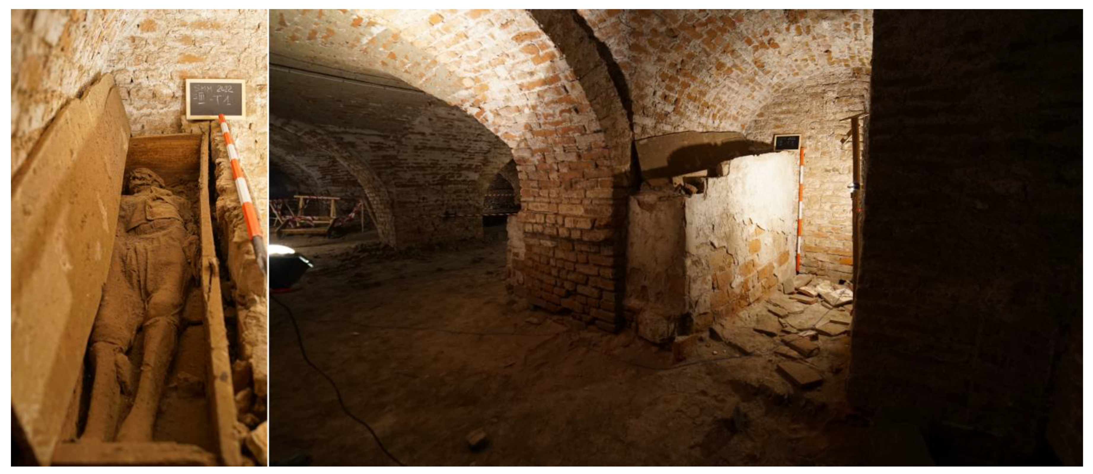
Funerary Unit 1 (Figure 2) is the first tomb encountered upon entering the hypogeum cemetery. This tomb, intended for a single individual, is positioned against a wall. It comprises a trapezoidal brick coffin, with bricks measuring 24.5 cm in length and 13 cm in height arranged in a regular band pattern. The coffin is covered with a thin layer of mortar and plaster visible on the structure’s surface. The coffin appears partially set atop a base constructed from bricks arranged on their ends, likely remnants of an earlier structure. The coffin initially had a cover, which is now only discernible through the bricks lying at its base. The bricks that formed the cover are larger than those used in the main structure, measuring 33 cm in length and 18 cm in height. The overall size of the coffin, including the base, is 221 cm, while excluding the base, it measures 210 cm. The maximum height at the head end (to the west) is 154 cm, and the minimum height at the foot end (to the east) is 107 cm. The maximum width of the structure, including the base, is 56 cm; without the base, it is 54 cm, and the minimum width is 48 cm. Inside the brick coffin is a wooden coffin that is also trapezoidal and constructed from six boards, including the cover, which are nailed together at the sides. The wooden coffin measures 187 cm in length and approximately 25 cm in height, with maximum and minimum widths of 48 cm and 30 cm, respectively. Within the wooden coffin lies the body of a male individual in primary deposition, perfectly mummified and still retaining his clothing in excellent condition.
The “Rocca di Monselice” is localised on a hilltop between Euganean Hills to the north and Adige River to the south, and it is southwest of Padua, a city in the northeast of Italy. It seems that the foundations date back to the 6th century A.D. In 602, the Lombard period started, and between the 8th and 9th centuries, the Carolingian period occurred. In 1237, Frederick II, Duke of Swabia, demolished the pre-existing buildings on the Monselice hilltop to erect the fortified tower and the ring of walls. The important Saint Giustina church, probably erected before 968 A.D., is one of the destroyed buildings.
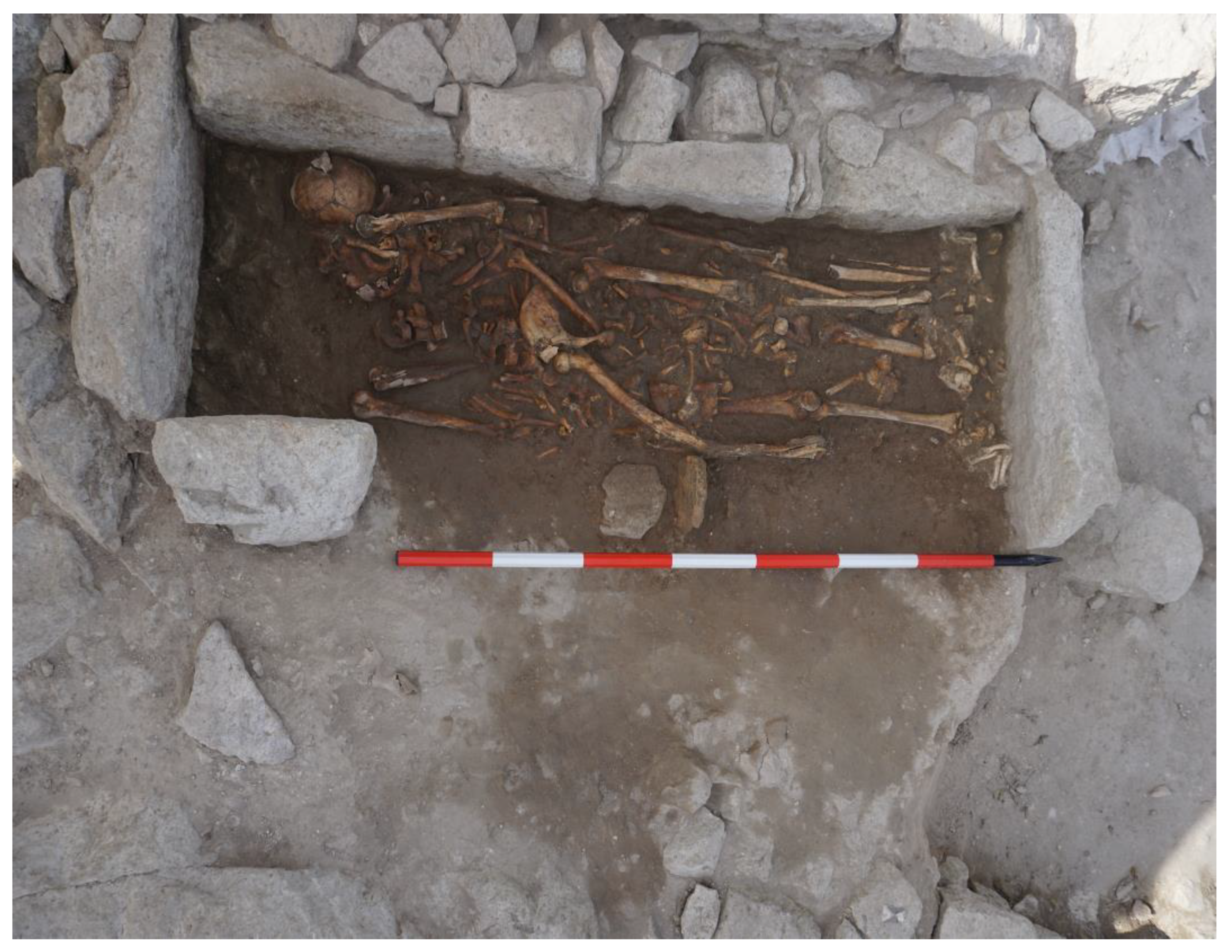
Recently, excavation campaigns (2021–2024), realised by the teachings of medieval archaeology of the University of Padua, allowed the study of many masonry structures preserved in different areas of the Monselice settlement. The southern area’s excavation revealed a different phase of the Saint Giustina church’s construction in addition to a funerary area used from the early Middle Ages to the 13th century and located to the west, east, and south of the church. Burials in the southern part of the cemetery were both in bare ground and a structure consisting of trachyte (a local stone) and/or clay. Grave Tb 10 (Figure 3), in the southern area, was chosen for our test with a structured-light scanner because of the planar conformation and the uniform sunlight over it. The grave, which is east–west-oriented, measures 135 × 54 × 38 cm, and the walls of its structure consist of big ashlars and slabs of trachyte without mortar binders. Regarding the southern side wall, only an ashlar is preserved in the southwest corner, and all other parties were removed during the demolition of the church. The northern side wall is composed of 4 slabs positioned edgewise, whereas the eastern and western side walls are only composed of 2 large slabs positioned edgewise. At least 5 skeletons are present in the Tb 10 grave, all of which are west–east-oriented and overlap with each other. Some were partially connected, but in the area of the trunk, a lot of bones were disarticulated. It was not possible to bring all skeletal remains to light at the same time due to their overlap and the ground cover, so they were brought to light and recovered progressively.

3. Results

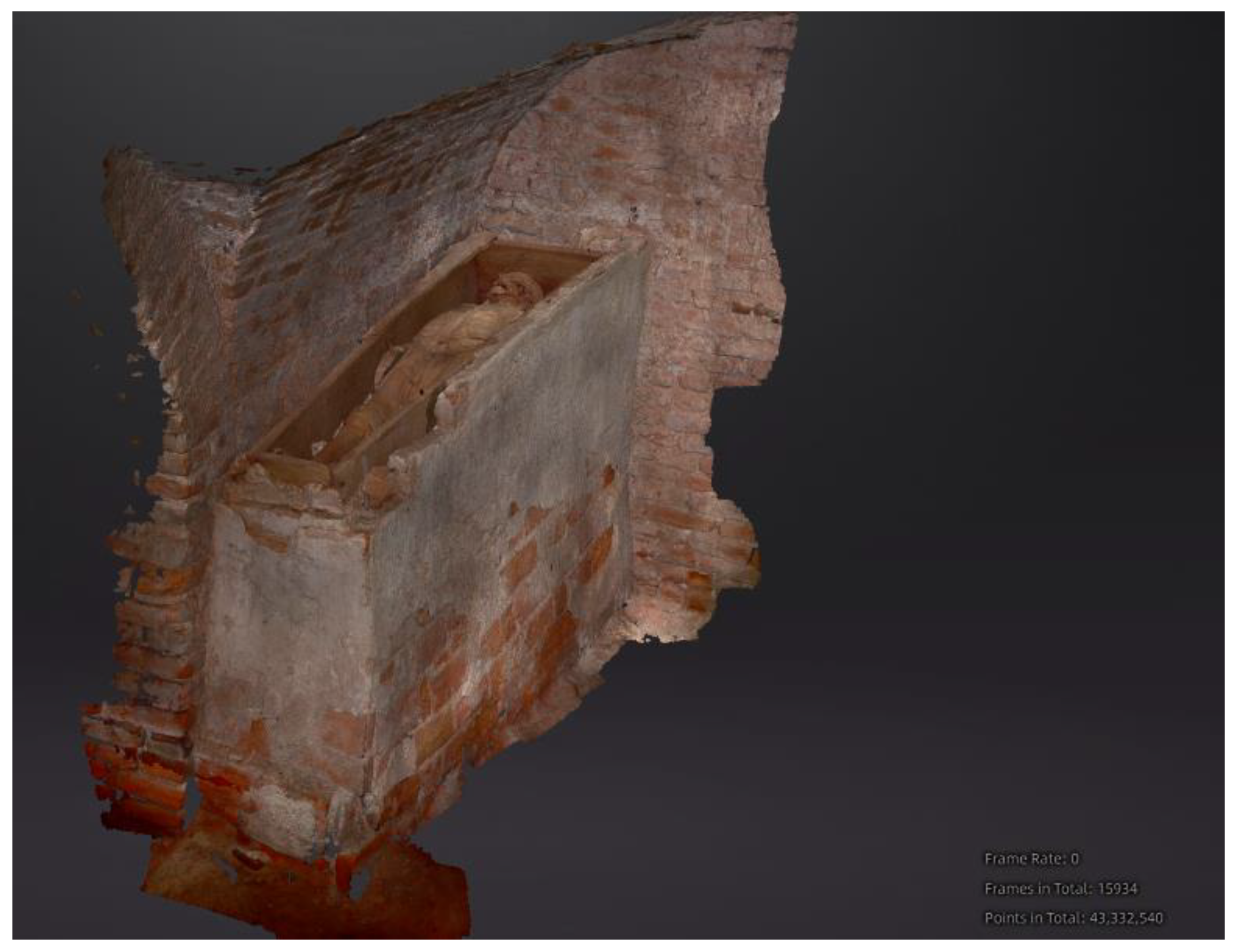
The low-cost structured-light scanner with VCSEL infrared technology did not create relevant problems for acquisitions in the tested dark environment. In 35 min, a point cloud of 43,332,540 points was acquired (Figure 4). The point cloud was of high quality according to the data quality indicator of the software. It was measured with the tool included in the software, and its dimensions reflected the dimensions of the object acquired. Both the texture and colour were acquired. A more formal evaluation of the geometry, texture, and colour will be performed in a more advanced stage of the research.
A different outcome was given by the scanning of Tb 10 from “Rocca di Monselice”. In 21 min, a point cloud of 7,964,750 points was acquired (Figure 5). The digitally acquired data were also of high quality in this case according to the data quality indicator of the software. However, the colour of the points resulted in a white colour. This result was confirmed via the texture of the model. This fact is the first proof that very strong light can affect acquisitions in very bright contexts with this scanner.

4. Discussion

The test carried out in Monselice provides evidence of the interference of sunlight on the acquisition with the low-cost handheld structured-light Einstar-Portable Handheld 3D Scanner. Specifically, the RGB camera of the scanner was hypothetically not capable of colour acquisition. However, a more structured test will be carried out to verify this statement. On the other side, a qualitative estimation of the point cloud’s density suggests that sunlight did not interfere with the acquisition of features.
The high number of points collected for the point cloud generated an obstacle for processing as the hardware of the workstation was not sufficient to generate the model via the software supplied by the producer.
More tests need to be performed in a more controlled environment and with a quantitative evaluation of the results. These tests will include different survey schemes and a repeatability and reproducibility analysis with several examples of the same scanner. The measure of light quantity is necessary to identify a correlation with the texture’s alteration. A verification of the invariance of the point distance with respect to the working distance and the scanner’s orientation is also necessary. A comparison between the acquisition technique applied in this context and an Sfm (structure from motion) approach and other low-cost techniques is worthy of consideration.
For this purpose, it is important to note that Sfm requires highly technical skills for data acquisition and processing, which is substantially simplified via user-friendly software [11]. In fact, a suitable result requires the planning of a geometric scheme [21] to avoid distortions produced by both the camera and geometric configuration [13,22]. Furthermore, on-field processing is impracticable for close-range photogrammetry because of the extensive amount of time required to produce quality models, whereas structured-light scanning systems could have a lower processing time, and the result is hypothetically available directly on the field. In the research project, a verification of these statements is planned.
A quantitative evaluation of the point cloud’s geometry and texture is necessary to assess the accuracy of the measurement. A comparison with the point cloud obtained with metrological instrumentation and the use of a colourimeter will, respectively, provide a result in this direction.
As a conclusion, the tests demonstrate that in the chosen borderline environments, one characterised by deep darkness and the other by extreme light in the open air, the Einstar-Portable Handheld 3D Scanner is able to work, acquiring high-quality point clouds with respect to the data quality indicator. It shows a critical element in extreme sunlight where it does not reproduce colours.
The results are too preliminary to foresee the contribution of these data to anthropological studies. Various applications are currently being evaluated. Potentially, the development of technical protocols for the use of low-cost structured-light scanners in the field could lead to a reduction in documentation and recovery time. It could also increase the quantity and quality of the acquired data. These data could possibly enhance our comprehension of taphonomic processes and disturbance phenomena and facilitate more accurate attribution of each bone.
However, this technique can already be used to build 3D models to facilitate the enhancement of cultural heritage, specifically anthropological contexts, through the framework MAPOD4D [23].

Author Contributions

Writing—original draft: M.O.; Writing—review & editing: R.F., A.M., M.M. and M.L.; Project administration: R.T. All authors have read and agreed to the published version of the manuscript.

Funding

This research received no external funding.

Data Availability Statement

Data available on request.

Acknowledgments

Special thanks are given to Fondazione Cassa di Risparmio di Torino for financing the bioarchaeological project of the Cemetery of Santa Maria Maggiore in Vercelli. Excavations and research were carried out with the scientific direction (or supervision) of the Soprintendenza Archeologia, Belle Arti e Paesaggio per le province di Biella, Novara, Verbano-Cusio-Ossola e Vercelli, and the support and cooperation of Ufficio Diocesano per i Beni Culturali Ecclesiastici e l’Edilizia di Culto, Arcidiocesi Vercelli. As far as the archaeological part of the research, the project was carried out in collaboration with the University of Eastern Piedmont Department of Humanities as a partner of the project. We are also very thankful to Alexandra Chavarria from the University of Padua, scientific director of the Monselice excavation campaigns; SABAP—Area Metropolitana di Venezia e le province di Belluno, Padova e Treviso; Veneto Edifici Monumentali s.r.l.; Regione del Veneto. Funding source for Rocca of Monselice: PRIN2022, project number 2022BTT2Y2: Bioarchaeology of climatic change: an investigation on the Late Antique Little Ice Age (BIOLALIA), funded by European Union—Next Generation EU. Special thanks are also given to Filippo Di Marco for the constant support and advice during the processing and evaluation of the tests made with the scanner and Serenella Saccon for their contribution to the basic revision of the manuscript. Finally, we express our gratitude to the communities who developed the FLOSS software for their invaluable contribution, without which this manuscript could not have been written: the software Libre Office 24.2 with Mozilla Public License (MPL) v 2.0 for writing, GIMP 2.10.22 for image fixing, ShareX 16.1.0 for capturing screenshots, and Krita 5.1.5 with GNU General Public License (GPL) version 3 for scheme drawing.

Conflicts of Interest

The authors declare no conflicts of interest.

References

  1. Diara, F. Structured-Light Scanning and Metrological Analysis for Archaeology: Quality Assessment of Artec 3D Solutions for Cuneiform Tablets. Heritage 2023, 6, 6016–6034. [Google Scholar] [CrossRef]
  2. Kusuma Frisky, A.Z.; Fajri, A.; Brenner, S.; Sablatnig, R. Acquisition Evaluation on Outdoor Scanning for Archaeological Artifact Digitalization. In Proceedings of the VISIGRAPP—15th International Joint Conference on Computer Vision, Imaging and Computer Graphics Theory and Applications, Valletta, Malta, 27–29 February 2020; Farinella, G.M., Radeva, P., Braz, J., Eds.; SciTePress: Setúbal, Portugal, 2020; Volume 5, pp. 792–799. [Google Scholar]
  3. Menna, F.; Nocerino, E.; Remondino, F.; Dellepiane, M.; Callieri, M.; Scopigno, R. 3D Digitization of an Heritage Masterpiece—A Critical Analysis on Quality Assessment. Int. Arch. Photogramm. Remote Sens. Spat. Inf. Sci. 2016, 41, 675–683. [Google Scholar] [CrossRef]
  4. Russo, M.; Senatore, L.J. Low-Cost 3d Techniques for Real Sculptural Twins in the Museum Domain. Int. Arch. Photogramm. Remote Sens. Spat. Inf. Sci. 2022, 48, 229–236. [Google Scholar] [CrossRef]
  5. Maté-González, M.Á.; Aramendi, J.; González-Aguilera, D.; Yravedra, J. Statistical Comparison between Low-Cost Methods for 3D Characterization of Cut-Marks on Bones. Remote Sens. 2017, 9, 873. [Google Scholar] [CrossRef]
  6. Evgenikou, V.; Georgopoulos, A. Investigating 3D Reconstruction Methods for Small Artifacts. ISPRS-Int. Arch. Photogramm. Remote Sens. Spat. Inf. Sci. 2015, XL-5/W4, 101–108. [Google Scholar] [CrossRef]
  7. Garashchenko, Y.; Kogan, I.; Rucki, M. Comparative Accuracy Analysis of Triangulated Surface Models of a Fossil Skull Digitized with Various Optic Devices. Metrol. Meas. Syst. 2022, 29, 37–51. [Google Scholar] [CrossRef]
  8. Merella, M.; Farina, S.; Scaglia, P.; Caneve, G.; Bernardini, G.; Pieri, A.; Collareta, A.; Bianucci, G. Structured-Light 3D Scanning as a Tool for Creating a Digital Collection of Modern and Fossil Cetacean Skeletons (Natural History Museum, University of Pisa). Heritage 2023, 6, 6762–6776. [Google Scholar] [CrossRef]
  9. Bastir, M.; García-Martínez, D.; Torres-Tamayo, N.; Palancar, C.A.; Fernández-Pérez, F.J.; Riesco-López, A.; Osborne-Márquez, P.; Ávila, M.; López-Gallo, P. Workflows in a Virtual Morphology Lab: 3D Scanning, Measuring, and Printing. J. Anthropol. Sci. 2019, 97, 107–134. [Google Scholar] [CrossRef]
  10. Georgopoulos, A.; Ioannidis, C.; Valanis, A. Assessing the Performance of a Structured Light Scanner. Int. Arch. Photogramm. Remote Sens. Spat. Inf. Sci. 2010, 38, 251–255. [Google Scholar]
  11. Morena, S.; Barba, S.; Álvaro-Tordesillas, A. Shining 3D EinScan-Pro, Application and Validation in the Field of Cultural Heritage, from the Chillida-Leku Museum to the Archaeological Museum of Sarno. Int. Arch. Photogramm. Remote Sens. Spat. Inf. Sci. 2019, 42, 135–142. [Google Scholar] [CrossRef]
  12. Shining 3D EinStar|V-GER SHOP. Available online: https://shop.vger.eu/uncategorized/shining-3d-einstar/ (accessed on 29 June 2024).
  13. Williams, R.; Thompson, T.; Orr, C.; Taylor, G. Developing a 3D Strategy: Pipelines and Recommendations for 3D Structured Light Scanning of Archaeological Artefacts. Digit. Appl. Archaeol. Cult. Herit. 2024, 33, e00338. [Google Scholar] [CrossRef]
  14. Dickin, F.; Pollard, S.; Adams, G. Mapping and Correcting the Distortion of 3D Structured Light Scanners. Precis. Eng. 2021, 72, 543–555. [Google Scholar] [CrossRef]
  15. Colosimo, B.M.; Pacella, M.; Senin, N. Multisensor Data Fusion via Gaussian Process Models for Dimensional and Geometric Verification. Precis. Eng. 2015, 40, 199–213. [Google Scholar] [CrossRef]
  16. Jacobs, L.; Dvorak, J.; Cornelius, A.; Zameroski, R.; No, T.; Schmitz, T. Structured Light Scanning Artifact-Based Performance Study. Manuf. Lett. 2023, 35, 873–882. [Google Scholar] [CrossRef]
  17. Gupta, M.; Yin, Q.; Nayar, S.K. Structured Light in Sunlight. In Proceedings of the 2013 IEEE International Conference on Computer Vision, Sydney, Australia, 1–8 December 2013; pp. 545–552. [Google Scholar]
  18. Profico, A.; Bellucci, L.; Buzi, C.; Di Vincenzo, F.; Micarelli, I.; Strani, F.; Tafuri, M.A.; Manzi, G. Virtual Anthropology and Its Application in Cultural Heritage Studies. Stud. Conserv. 2019, 64, 323–336. [Google Scholar] [CrossRef]
  19. Errickson, D.; Grueso, I.; Griffith, S.J.; Setchell, J.M.; Thompson, T.J.U.; Thompson, C.E.L.; Gowland, R.L. Towards a Best Practice for the Use of Active Non-Contact Surface Scanning to Record Human Skeletal Remains from Archaeological Contexts. Int. J. Osteoarchaeol. 2017, 27, 650–661. [Google Scholar] [CrossRef]
  20. Licata, M.; Tesi, C.; Larentis, O.; Destefanis, E.; Garanzini, F.; Ciliberti, R.; Fusco, R. Elongated Styloid Process of an Autopsied Skull from the Cemetery of Santa Maria Maggiore in Vercelli, 18th-19th Century (Piedmont, Northern Italy). Anthropol. Anz. 2024, 81, 209–218. [Google Scholar] [CrossRef] [PubMed]
  21. Balletti, C.; Bertellini, B.; Gottardi, C.; Guerra, F. Geomatics Techniques for the Enhancement and Preservation of Cultural Heritage. Int. Arch. Photogramm. Remote Sens. Spat. Inf. Sci. 2019, XLII-2/W11, 133–140. [Google Scholar] [CrossRef]
  22. Luhmann, T.; Robson, S.; Kyle, S.; Boehm, J. Close-Range Photogrammetry and 3D Imaging; De Gruyter: Berlin, Germany; Boston, MA, USA, 2020; ISBN 978-3-11-060725-3. [Google Scholar]
  23. Mazzucchi, A.; Taglioretti, R.; Marinato, M. MAPOD4D “CSSG”: The First Metaverse on the Skeletal Recovery in the Experimental Field Laboratory for the Research on Technological Applications in the Archaeological UNESCO Site of Castelseprio—San Giovanni. JBR 2024, 2, e2024006. [Google Scholar]
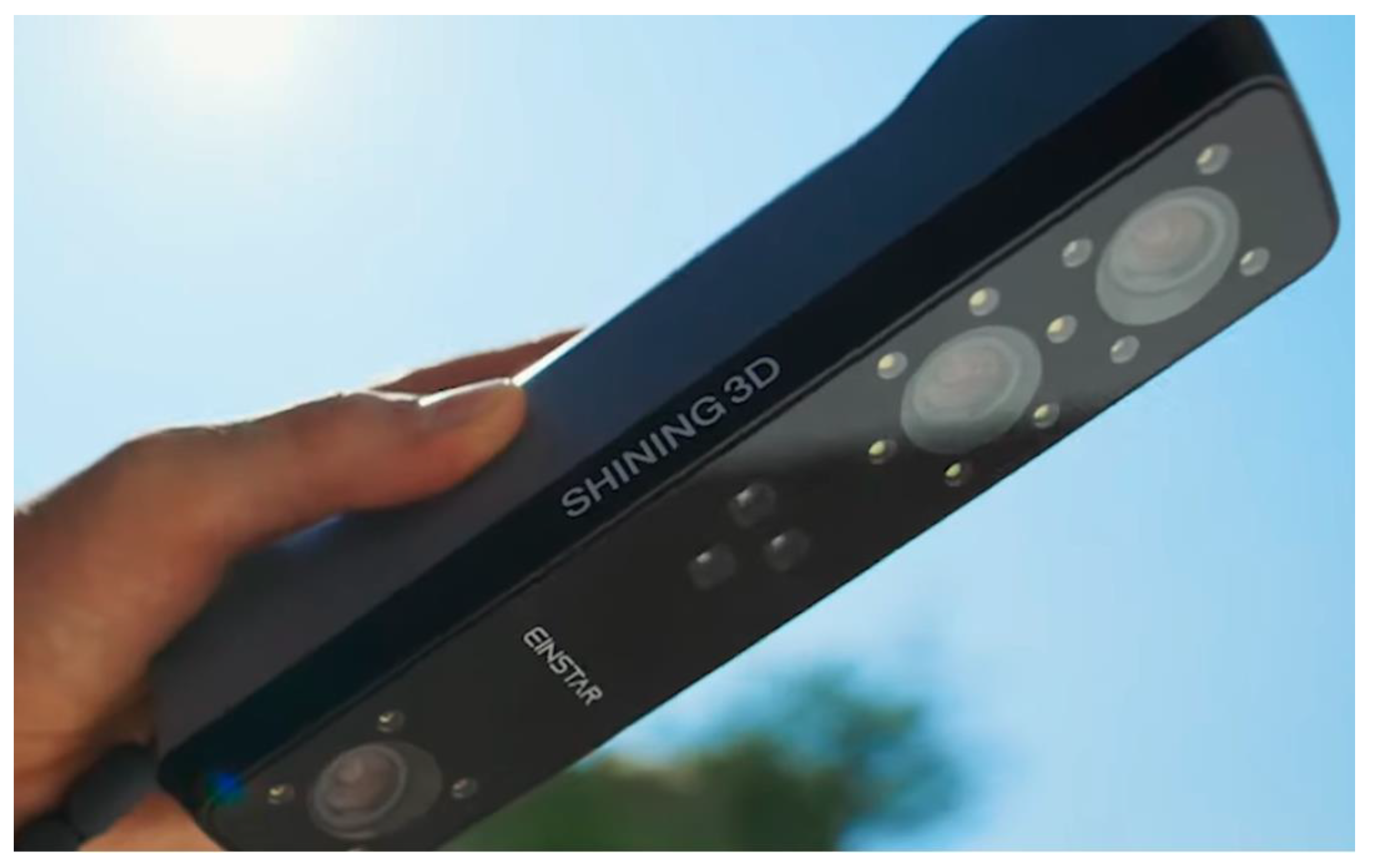
Figure 1. Structured-light Einscan-Portable Handheld 3D Scanner.
Heritage 07 00236 g001
Scheme 1. Scheme of context 1 and the surrounding area with identified planes (numbered from 1 to 5). The blue rectangle indicates the joint area between plane 3 and plane 1 and between plane 3 and plane 2.
Heritage 07 00236 sch001
Figure 2. Funerary Unit 1 from the Church of Santa Maria Maggiore in Vercelli.
Heritage 07 00236 g002
Figure 3. Tb10 of “Rocca di Monselice” immediately before the digital acquisition.
Heritage 07 00236 g003
Figure 4. The point cloud obtained from the acquisition of Funerary Unit 1 from the Church of Santa Maria Maggiore in Vercelli.
Heritage 07 00236 g004
Figure 5. The point cloud obtained from the acquisition of Tb10 from “Rocca di Monselice” regarding an intermediate level during the recovery of the skeletons.
Heritage 07 00236 g005
Disclaimer/Publisher’s Note: The statements, opinions and data contained in all publications are solely those of the individual author(s) and contributor(s) and not of MDPI and/or the editor(s). MDPI and/or the editor(s) disclaim responsibility for any injury to people or property resulting from any ideas, methods, instructions or products referred to in the content.