
Conceptual and Analytical Framework as Flood Risk Mapping Subsidy


Abstract
:1. Introduction
2. Study Area
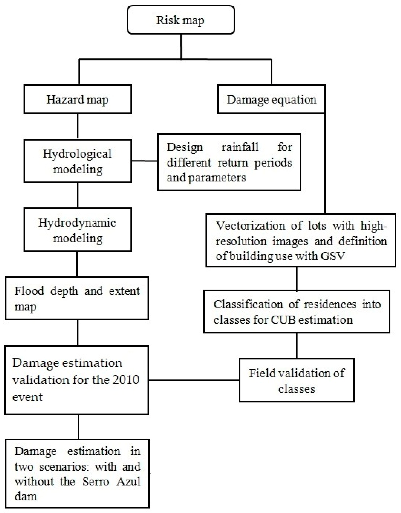
3. Materials and Methods
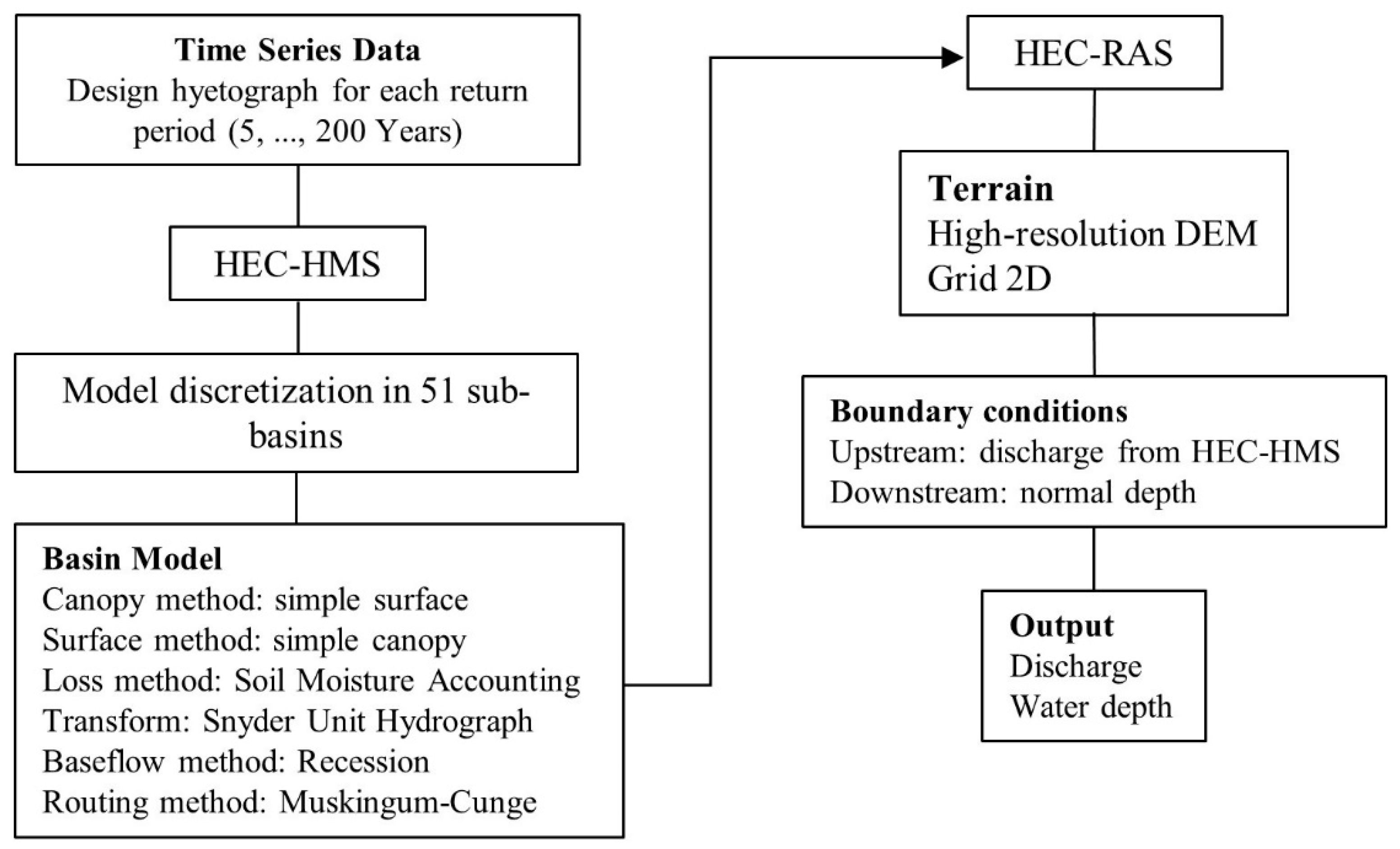
3.1. Hydrological and Hydrodynamic Modeling
3.2. Damage Analysis
3.2.1. Components of Risk
- CRE—cost of damages to buildings
- CUB—basic unit cost of construction
- PED—percentage of damaged building
- AIC—inundated built area (m2)
- CRC—Damage costs for the contents of a building
- CCIP—Damage costs of a standard design
- AIP—Area of the standard design R1-N (m2)
- Fm—Multiplier factor (values in the Supplementary Material)
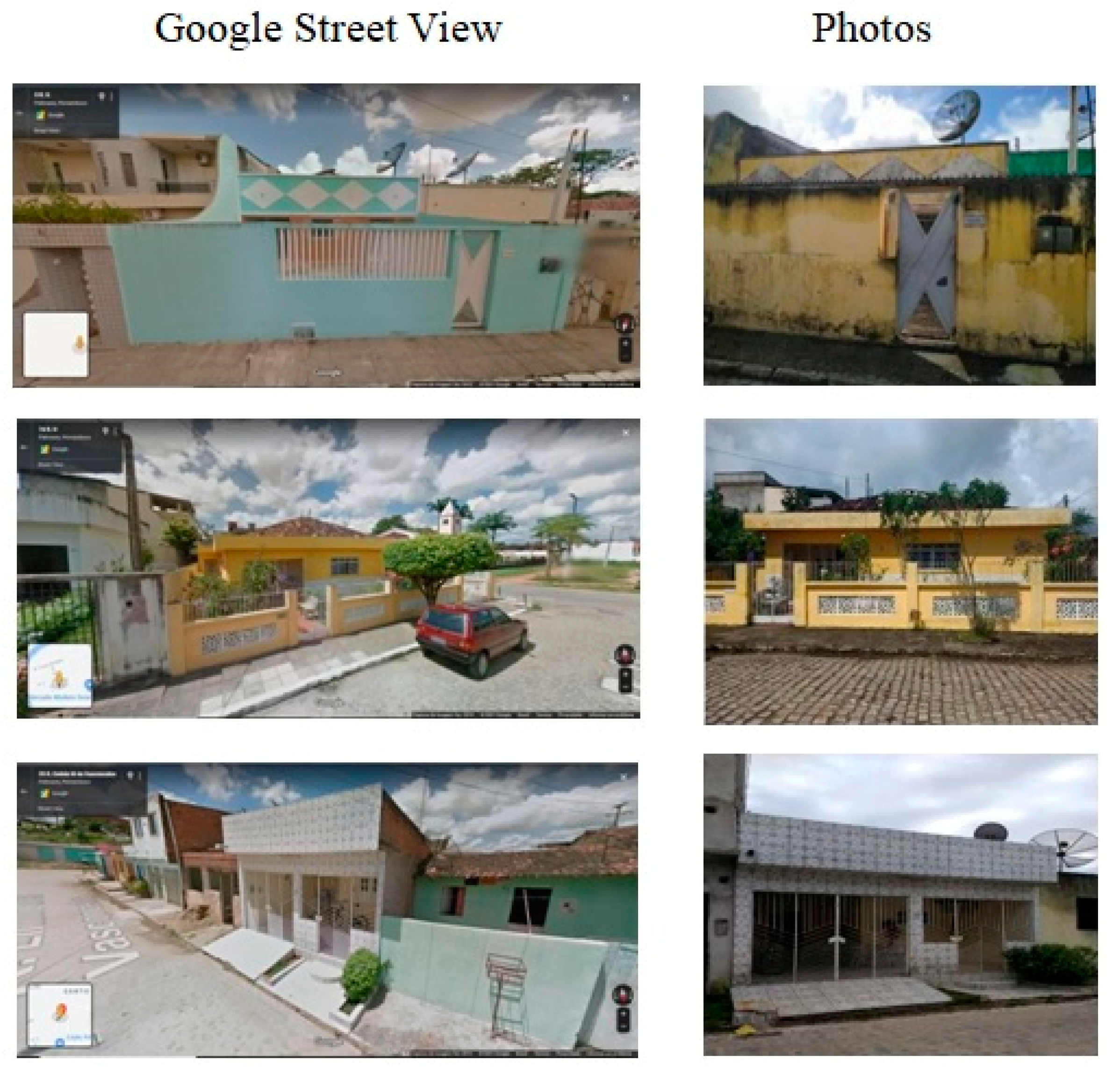
3.2.2. Buildings Dataset
4. Results
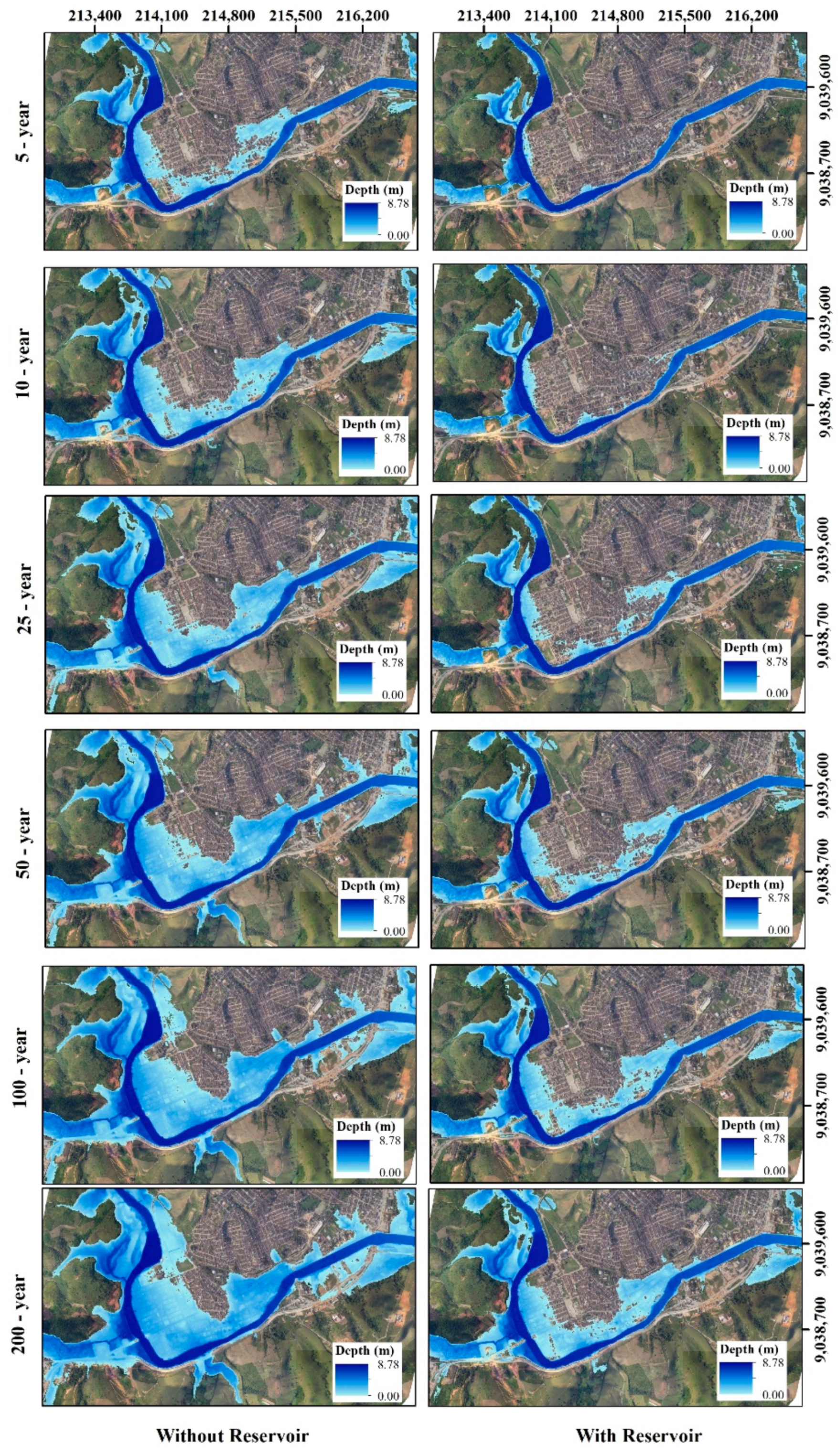
4.1. Flood Simulation
4.2. Damage Estimation
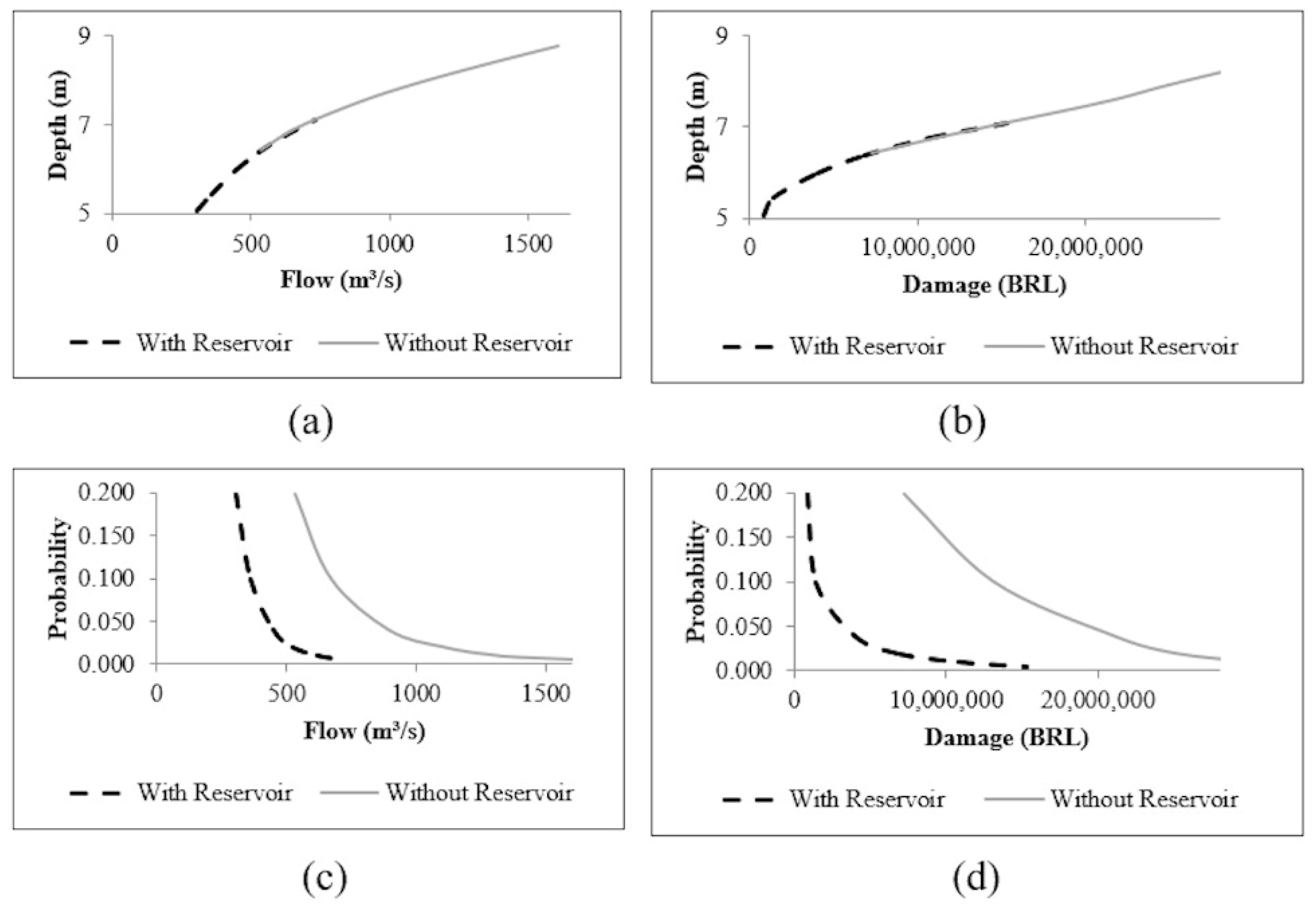
4.3. Risk Curve for Estimation of Benefits
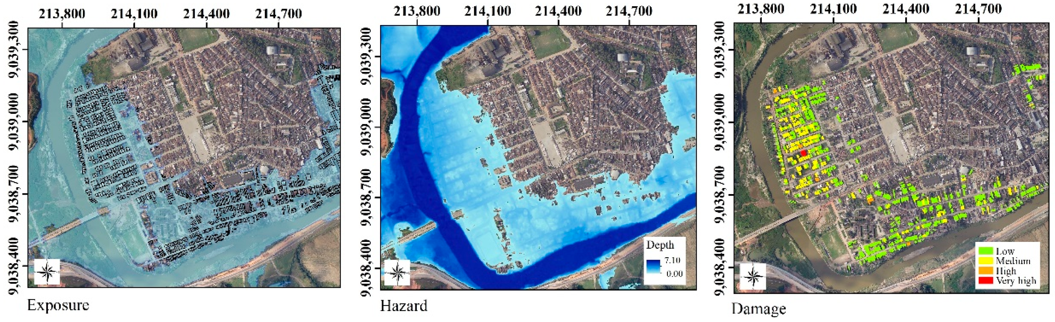
4.4. Maps of Risk Elements
4.5. Discussion
5. Conclusions
Supplementary Materials
Author Contributions
Funding
Conflicts of Interest
References
- Roos, M.M.D.; Hartmann, T.T.; Spit, T.T.J.M.; Johann, G.G. Constructing risks—Internalisation of flood risks in the flood risk management plan. Environ. Sci. Policy 2017, 74, 23–29. [Google Scholar] [CrossRef]
- UNISDR—The United Nations Office for Disaster Risk Reduction. Sendai Framework for Disaster Risk Reduction 2015–2030; UNISDR: Geneva, Switzerland, 2015. [Google Scholar]
- Tanwattana, P. Systematizing community-based disaster risk management (CBDRM): Case of urban flood-prone community in Thailand upstream area. Int. J. Disaster Risk Reduct. 2018, 28, 798–812. [Google Scholar] [CrossRef]
- Jahangiri, K.; Eivazi, M.-R.; Mofazali, A.S. The role of foresight in avoiding systematic failure of natural disaster risk management. Int. J. Disaster Risk Reduct. 2017, 21, 303–311. [Google Scholar] [CrossRef]
- Fadel, A.W.; Marques, G.F.; Goldenfum, J.A. Mapeamento do risco de prejuízo como medida de gestão de adaptação às inundações. Geociências 2018, 37, 121–136. [Google Scholar] [CrossRef] [Green Version]
- Whelchel, A.W.; Reguero, B.G.; Wesenbeeck, B.; Renaud, F.G. Advancing disaster risk reduction through the integration of science, design, and policy into eco-engineering and several global resource management processes. Int. J. Disaster Risk Reduct. 2018, 32, 29–41. [Google Scholar] [CrossRef] [Green Version]
- McGrath, H.; Stefanakis, E.; Nastev, M. Sensitivity nalysis of flood damage estimates: A case study in Fredericton, New Brunswick. Int. J. Disaster Risk Reduct. 2015, 14, 379–387. [Google Scholar] [CrossRef]
- Cammerer, H.; Thieken, A.H.; Lammel, J. Adaptability and transferability of flood loss functions in residential areas. Nat. Hazards Earth Syst. Sci. 2013, 13, 3063–3081. [Google Scholar] [CrossRef] [Green Version]
- Arrighi, C.; Mazzanti, B.; Pistone, F.; Castelli, F. Empirical flash flood vulnerability functions for residential buildings. SN Appl. Sci. 2020, 2, 904. [Google Scholar] [CrossRef] [Green Version]
- Molinari, D.; Bruijn, K.M.; Castillo-Rodriguez, J.T.; Aronica, G.T.; Bouwer, L.M. Validation of flood risk models: Current practice and possible improvements. Int. J. Disaster Risk Reduct. 2019, 33, 441–448. [Google Scholar] [CrossRef]
- Almeida, L.V.Q.; Eleuterio, J.C. Estado da arte de curvas de danos potenciais de inundações para o setor habitacional. In Proceedings of the XXIII Simpósio Brasileiro de Recursos Hídricos, Foz do Iguaçu, Brazil, 24–28 November 2018. [Google Scholar]
- APAC. Bacias Hidrográficas. Available online: http://www.apac.pe.gov.br/ (accessed on 24 May 2018).
- CONDEPE/FIDEM. Rio Una, GL 4 e GL 5; Agência Estadual de Planejamento e Pesquisas de Pernambuco: Recife, Brazil, 2006; 85p.
- Ribeiro Neto, A.; Cirilo, J.A.; Dantas, C.E.O.; Silva, E.R. Caracterização da formação de cheias na bacia do rio Una em Pernambuco: Simulação hidrológica-hidrodinâmica. Rev. Bras. Recur. Hídricos 2015, 20, 394–403. [Google Scholar]
- IBGE—Instituto Brasileiro de Geografia e Estatística. Palmares. Rio de Janeiro: IBGE. 2014. Available online: http://cidades.ibge.gov.br/brasil/pe/palmares (accessed on 14 November 2018).
- PERNAMBUCO. Plano Hidroambiental da Bacia Hidrográfica do Rio Capibaribe: Tomo I—Diagnóstico Hidroambiental; Secretaria de Recursos Hídricos e Energéticos (SRHE): Recife, Brazil, 2010; Volume 01/03. [Google Scholar]
- Dantas, C.E.O. Previsão e Controle de Inundações em Meio Urbano com Suporte de Informações Espaciais de Alta Resolução. Ph.D. Thesis, Federal University of Pernambuco, Recife, Brazil, 2012. [Google Scholar]
- Alves, F.H.B.A. Sistema de Previsão de Enchentes: Integração de Modelos de Previsão de Chuva, Simulação Hidrológica e Hidrodinâmica. Master’s Dissertation, Federal University of Pernambuco, Recife, Brazil, 2017. [Google Scholar]
- Batista, L.F.D.R.; Ribeiro Neto, A.; Montenegro, S.M.G.L.M. Adaptation mechanisms for extreme events in the Capibaribe River Basin, Brazil. In Proceedings of the XVI World Water Congress, Cancun, Mexico, 29 May–3 June 2017. [Google Scholar]
- ITEP—Instituto de Tecnologia de Pernambuco. Relatório de Impacto Ambiental: Estudo de Impacto Ambiental—EIA: Sistema de Controle de Cheias da Bacia do Rio Una–Barragem Serro Azul; Instituto de Tecnologia de Pernambuco: Recife, Brazil, 2011; 41p. [Google Scholar]
- Nakagawa, S.; Samarasinghe, G.; Haddaway, N.R.; Westgate, M.J.; O’Dea, R.E.; Noble, D.W.A.; Lagisz, M. Research weaving: Visualizing the future of research synthesis. Trends Ecol. Evol. 2019, 4, 224–238. [Google Scholar] [CrossRef] [Green Version]
- Li, W.; Lin, K.; Zhao, T.; Lan, T.; Chen, X.; Du, H.; Chen, H. Risk assessment and sensitivity analysis of flash floods in ungauged basins unsing coupled hydrologic and hydrodynamic models. J. Hydrol. 2019, 572, 108–120. [Google Scholar] [CrossRef]
- Gai, L.; Nunes, J.P.; Baartman, J.E.M.; Zhang, H.; Wang, F.; Roo, A.; Ritsema, C.J.; Geissen, V. Assessing the impact of human interventions on floods and low flows in the Wei River Basin in China using the LISFLOOD model. Sci. Total Environ. 2019, 541, 611–625. [Google Scholar] [CrossRef] [PubMed]
- Devi, N.N.; Sridharan, B.; Kuiry, S.N. Impact of urban sprawl on future flooding in Chennai city, India. J. Hydrol. 2019, 574, 486–496. [Google Scholar] [CrossRef]
- Nharo, T.; Makurira, H.; Gumindoga, W. Mapping floods in the middle Zambezi Basin using earth observation and hydrological modeling techniques. Phys. Chem. Earth 2019, 114, 102787. [Google Scholar] [CrossRef]
- Hadimlioglu, A.; Scott, A.K.; Starek, M.J. FloodSim: Flood simulation and visualization framework using position-based fluids. J. Geo-Inf. 2020, 9, 163. [Google Scholar] [CrossRef] [Green Version]
- Brunner, G.W. HEC-RAS, River Analysis System Hydraulic Reference Manual; U.S. Army Corps of Engineers: Davis, CA, USA, 2016; 547p.
- Lima Neto, O.C.; Ribeiro Neto, A.; Alves, F.H.B.; Cirilo, J.A. Sub-daily hydrological-hydrodynamic simulation in flash flood basins: Una River (Pernambuco/Brazil). Rev. Ambiente Água 2020, 15, e2556. [Google Scholar] [CrossRef]
- Chow, V.T.; Maidment, D.R.; Mays, L.W. Applied Hydrology; McGraw-Hill: New York, NY, USA, 1988. [Google Scholar]
- Alcântara, L.R.P. Espacialização dos Parâmetros das Equações de Intensidade—Duração E Frequência Para Municípios da Mata Sul do Estado de Pernambuco. Bachelor’s Dissertation, Federal University of Pernambuco, Caruaru, Brazil, 2018. [Google Scholar]
- Albano, R.; Mancusi, L.; Abbate, A. Improving flood risk analysis for effectively supporting the implementation of flood risk management plans: The case study of “Serio” Valley. Environ. Sci. Policy 2017, 75, 158–172. [Google Scholar] [CrossRef]
- Kreibich, H.; Piroth, K.; Seifert, I.; Maiwald, H.; Kunert, U.; Schwarz, J.; Merz, B.; Thieken, A.H. Is flow velocity a significant parameter in flood damage modeling? Nat. Hazards Earth Syst. Sci. 2009, 9, 1679–1692. [Google Scholar] [CrossRef]
- Ribeiro Neto, A.; Batista, L.F.D.R.; Coutinho, R.Q. Methodologies for generation of hazard indicator maps and flood prone areas: Municipality of Ipojuca/PE. Rev. Bras. Recur. Hídricos 2016, 21, 377–390. [Google Scholar]
- Fadel, A.W.; Marques, G.F.; Goldenfum, J.A.; Medellin-Azuara, J.; Tilmant, A. Full Flood Cost: Insights from a risk analysis perspective. J. Environ. Eng. 2018, 144, 04018071. [Google Scholar] [CrossRef]
- Penning-Rowsell, E.C.; Chatterton, J.B. The Benefits of Flood Alleviation; Saxon House: Farnborough, UK, 1977; 297p. [Google Scholar]
- Win, S.; Zin, W.W.; Kawasaki, A.; San, Z.M.L.T. Establishment of flood damage function models: A case study in the Bago River Basin, Myanmar. Int. J. Disaster Risk Reduct. 2018, 28, 688–700. [Google Scholar] [CrossRef]
- Oubennaceur, K.; Chokmani, K.; Nastev, M.; Lhissou, R.; Alem, A.E. Flood risk mapping for direct damage to residential buildings in Quebec, Canada. Int. J. Disaster Risk Reduct. 2019, 33, 44–54. [Google Scholar] [CrossRef]
- Salgado, J.C.M. Avaliação Econômica de Projetos de Drenagem e de Controle de Inundações em Bacias Urbanas. Master’s Dissertation, Federal University of Rio de Janeiro, Rio de Janeiro, Brazil, 1995. [Google Scholar]
- Nagem, F.R.M. Avaliação Econômica dos Prejuízos Causados Pelas Cheias Urbanas. Master’s Dissertation, Federal University of Rio de Janeiro, Rio de Janeiro, Brazil, 2008. [Google Scholar]
- World Bank. Avaliação de Perdas e Danos: Inundações Bruscas em Pernambuco—Junho de 2010; World Bank: Brasília, Brazil, 2012; 75p. [Google Scholar]
- Brunner, G.W. CEIWR-HEC. HEC-RAS, River Analysis System User’s Manual Version 5.0; U.S. Army Corps of Engineers: Davis, CA, USA, 2016; 962p.
- Lima Neto, O.C. Modelagem Hidrológica e Hidrodinâmica com Intervalo de Tempo Sub-Diário na Bacia do rio Una em Pernambuco. Master’s Dissertation, Federal University of Pernambuco, Recife, Brazil, 2019. [Google Scholar]
- Ongdas, N.; Akiyanova, F.; Karakulov, Y.; Muratbayeva, A.; Zinabdin, N. Application of HEC-RAS (2D) for flood hazard maps generation for Yesil (Ishim) River in Kazakhstan. Water 2020, 12, 2672. [Google Scholar] [CrossRef]
- NBR 12721; Avaliação de Custos de Construção para Incorporação Imobiliária e Outras Disposições para Condomínios Edilícios. Associação Brasileira de Normas Técnicas (ABNT): Rio de Janeiro, Brazil, 2005.
- Amarnath, G.; Umer, Y.M.; Alahacoon, N.; Inada, Y. Modelling the flood-risk extent using LISFLOOD-FP in a complex watershed: Case study of Mundeni Aru River Basin, Sri Lanka. Int. Assoc. Hydrol. Sci. 2015, 370, 131–138. [Google Scholar] [CrossRef]
- Andrade, M.M.N.; Szlafsztein, C.F. Vulnerability assessment including tangible and intangible components in the índex composition: Na Amazon case study of flooding and flash flooding. Sci. Total Environ. 2018, 630, 903–912. [Google Scholar] [CrossRef]
- Tîncu, R.; Zêzere, J.L.; Cracium, I.; Lazar, G.; Lazar, I. Quantitative micro-scale flood risk assessment in a section of the Trotus River, Romania. Land Use Policy 2020, 95, 103881. [Google Scholar] [CrossRef]
- Goerl, R.F.; Kobiyama, M.; Pellerin, J.R.G. Proposta metodológica para mapeamento de áreas de risco de inundação: Estudo de caso do município de Rio Negrinho–SC. Bol. Geogr. 2012, 30, 81–100. [Google Scholar] [CrossRef] [Green Version]
- Shrestha, B.B.; Kawasaki, A. Quantitative assessment of flood risk with evaluation of the effectiveness of dam operation for flood control: A case of the Bago River Basin of Myanmar. Int. J. Disaster Risk Reduct. 2020, 50, 101707. [Google Scholar] [CrossRef]


| Standard Design | BRL/m2 |
|---|---|
| R1-B | 1690.30 |
| R1-N | 2034.58 |
| R1-A | 2585.64 |
| RP1Q | 1541.08 |
| Standard Design | Water Depths (m) | ||||
|---|---|---|---|---|---|
| 0.50 a 0.75 | 0.75 a 1.00 | 1.00 a 1.50 | 1.50 a 2.00 | 2.00 a 2.50 | |
| R1-B | 0.095 | 0.164 | 0.170 | 0.196 | 0.210 |
| R1-N | 0.056 | 0.130 | 0.137 | 0.167 | 0.183 |
| R1-A | 0.042 | 0.133 | 0.137 | 0.164 | 0.173 |
| RP1Q | 0.040 | 0.142 | 0.147 | 0.174 | 0.183 |
| Return Period (Years) | Reference Discharge from Dantas [17] (m³/s) | HEC-HMS without Flow Ratio (m³/s) | HEC-HMS with Flow Ratio (m³/s) | HEC-RAS (m³/s) |
|---|---|---|---|---|
| 5 | 475 | 3541 | 563 | 535 |
| 10 | 638 | 4322 | 705 | 670 |
| 25 | 818 | 5581 | 938 | 898 |
| 50 | 1088 | 6672 | 1144 | 1097 |
| 100 | 1320 | 7969 | 1382 | 1335 |
| 200 | 1570 | 3541 | 1656 | 1607 |
| Standard Design | Threshold (m2) |
|---|---|
| RP1Q | 0–39.56 |
| R1-B | 39.56–58.64 |
| R1-N | 58.64–92.21 |
| R1-A | 92.21–110.33 |
| Return Period (Years) | Building Structure (BRL) | Inventory (BRL) | ||
|---|---|---|---|---|
| Without Reservoir | With Reservoir | Without Reservoir | With Reservoir | |
| 5 | 3,792,011.98 | 354,954.69 | 3,004,784.01 | 404,689.39 |
| 10 | 8,848,708.64 | 558,847.12 | 3,757,347.57 | 775,503.50 |
| 25 | 15,563,438.55 | 1,731,554.14 | 4,682,790.48 | 1,957,286.92 |
| 50 | 18,980,767.52 | 3,546,706.46 | 5,263,626.74 | 2,885,755.04 |
| 100 | 23,239,583.90 | 6,733,074.43 | 5,643,534.94 | 3,515,636.04 |
| 200 | 27,167,627.22 | 10,835,456.37 | 5,987,146.00 | 3,927,110.04 |
Publisher’s Note: MDPI stays neutral with regard to jurisdictional claims in published maps and institutional affiliations. |
© 2022 by the authors. Licensee MDPI, Basel, Switzerland. This article is an open access article distributed under the terms and conditions of the Creative Commons Attribution (CC BY) license (https://creativecommons.org/licenses/by/4.0/).
Share and Cite
Batista, L.F.D.R.; Ribeiro Neto, A. Conceptual and Analytical Framework as Flood Risk Mapping Subsidy. GeoHazards 2022, 3, 395-411. https://doi.org/10.3390/geohazards3030020
Batista LFDR, Ribeiro Neto A. Conceptual and Analytical Framework as Flood Risk Mapping Subsidy. GeoHazards. 2022; 3(3):395-411. https://doi.org/10.3390/geohazards3030020
Chicago/Turabian StyleBatista, Larissa Ferreira D. R., and Alfredo Ribeiro Neto. 2022. "Conceptual and Analytical Framework as Flood Risk Mapping Subsidy" GeoHazards 3, no. 3: 395-411. https://doi.org/10.3390/geohazards3030020