Abstract
Virtual reality (VR) is a promising new educational and training tool in the field of disaster and emergency management, especially for hazards that are not frequent or well known to the public and require spatial and situational understanding. The objective of this paper is to describe an educational VR simulation that was developed based on a landslide that really occurred in Southern Malawi during the March 2023 Cyclone Freddy. The cyclone induced several landslides that caused many casualties and significant damage. The VR simulation framework consisted of four critical steps using Unity3D for the creation of the simulation including data preparation, terrain and environmental modeling, landslide simulation development, and virtual reality interactions. The simulation scenarios were diversified to include three distinct landscapes that can help users learn how factors such as terrain can influence landslide impacts. The VR simulation offers users an intimate, firsthand experience of the landslide’s unfolding and allows users the ability to explore various facets of the landslide phenomena. This VR simulation aims to provide an educational tool to facilitate an in-depth understanding of and interaction with a real-word landslide to learn about the impacts of landslides and how different factors can influence these impacts.
1. Introduction
Over the past decade, there has been an emergence of the use of virtual reality (VR) applications as a tool in disaster management education, training, and operations [1]. Virtual reality is the use of technology to simulate reality with scenes and objects that appear to be real, immersing the user in a virtual space. Using a headset, users are placed into a three-dimensional experience where they can explore and interact with a simulated environment. While VR gained popularity through its use in gaming, it is also being used in many other fields such as engineering, military training, architectural design, education, learning, and social skill training, therapy, and medical training [2,3].
The utilization of VR for educational purposes is still in its infancy; however, the possibilities for its application in education are vast, and there are many promising studies on the benefits of using VR for education [3,4]. These studies have demonstrated using VR to improve student attention and motivation, encourage “doing” rather than just observing, and immersing students in educational activities to enhance their understanding of a topic [3,4]. In addition, using VR, students can be transported to different environments that might be too dangerous or impossible to visit in real life (e.g., a disaster, space, historical periods in time, underwater, etc.) [3]. Despite the many benefits of using VR, many limitations have been noted including technological limits, accessibility concerns, and potential side effects [3]. While VR as a technology is quite advanced, there is still much work to be conducted in terms of standardization and content development before it can be fully utilized for all possible applications and purposes [3,5]. Compared to its earlier stages in development, VR is much more accessible in terms of cost, but it is still a large barrier to the growth of VR being used as a household technology or for standard use in the educational curriculum [3]. Another documented issue that may impact the widespread uptake and utilization of VR is cybersickness, where users feel motion sickness symptoms such as nausea, dizziness, sweating, or even vomiting from using VR technology [3,6]. To date, most studies on the use of VR in education have been conducted in higher education settings or for adults with little research on younger children and in people with disabilities [4,7]. In addition, most of the research is on education in the field of science, technology, and mathematics [4,7]. These studies generally investigate the educational value and learning outcomes from using VR, but there are a limited number of studies that evaluate students or teachers’ experiences and attitudes towards the use of VR for educational purposes [7].
Since the early 2000s, research on landslides has shown substantial growth as researchers try to better understand the hazard to ultimately prepare for and mitigate loss from future landslide events [8]. Landslides are a mass movement of rock, earth, or debris, down a sloped piece of land that can occur suddenly or slowly over long periods of time [9,10]. They are a common natural hazard responsible for significant human and economic losses across the world [11,12]. Heavy rainfall resulting in saturation of the ground, erosion of the base of a slope, shaking due to earthquakes and volcanic eruptions, and changes in the strength of material through weathering are the main causes of landslides [10]. While they can be caused by many factors, rainfall caused by tropical storms, cyclones, hurricanes, and typhoons are the most frequent triggers of landslide events in Asia, Africa, and the Americas [11]. It is anticipated that the negative impacts of natural disasters on society will continue to worsen due to land use, urbanization, infrastructure development, and climate change [13]. With the increase in global temperatures, there is an increased risk of intensity of storms, including tropical cyclones with higher wind speeds, which is one of the main triggers of landslide events [14].
It is therefore imperative to continue to prepare for and mitigate future landslides through continued understanding of the hazard and its associated risks. There are many tools currently available to assist with forecasting future landslide events and conducting risk assessments. Landslide investigations have been using modeling, remote sensing (RS), and geographic information system (GIS) environments with the aim of providing more spatial analysis and visualization of this type of hazard [15,16]. In addition, multiple space–time and machine learning-based simulations and models of landslides that have been developed, which are useful for understanding the difficultly of space–time modeling [17,18,19]. VR is an extremely promising tool for the enhancement of learning and education in the field of disaster management, especially for hazards such as landslides that often require spatial understanding. Research in this area has been rapidly growing over the past five years as demonstrated in a recent systematic review focused on virtual and augmented reality in disaster management [1]. This systematic review found that the major application areas of virtual and augmented reality in the field of disaster management are computer simulation modeling, interaction techniques, training, infrastructure assessment and reconnaissance, and public awareness [1]. Most studies in this field did not focus on a specific disaster, but instead used VR to focus on disaster preparedness, rescue, and reconstruction with an assumed disaster scenario (e.g., fire, flood, mass casualty event) [1]. There are now many examples of researchers using VR to simulate disasters to support disaster risk reduction and emergency response training particularly for disasters such as earthquakes, tsunamis, and fires; however, this is still an emerging area of research [20,21,22]. Currently, there are a limited number of studies published on VR applications related to landslides [23,24,25,26,27,28].
The objective of this paper is to describe a VR simulation that was developed mimicking a real-world landslide to be used for education and training of public and practitioners. Cyclone Freddy induced several landslides that caused mass destruction in Malawi in March 2023, one of which is used as the case for this simulation. The VR simulation framework, detailed herein, follows a meticulous approach using Unity3D with four critical steps for the creation of a comprehensive landslide simulation. This VR simulation aims to provide an educational tool to facilitate an in-depth understanding of and interaction with a real-world landslide to learn about the potential impacts of landslides and how different factors can influence these impacts.
2. Materials and Methods
2.1. Landslide Case
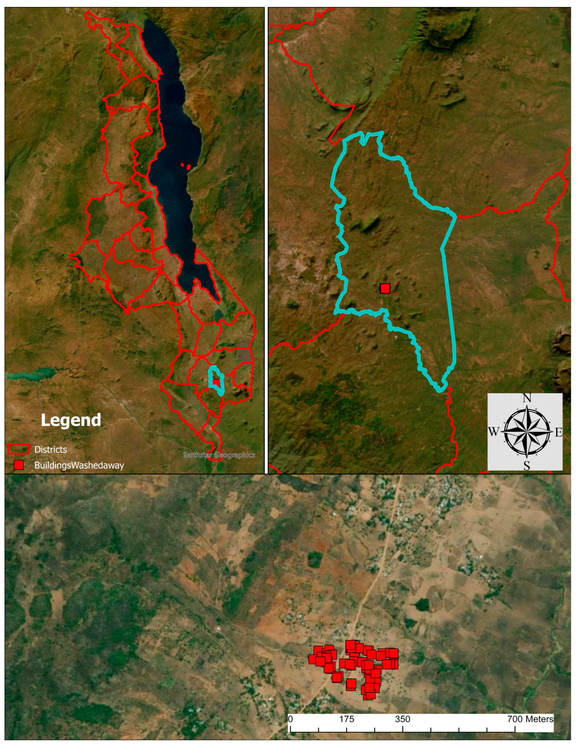
The small village of Mtauchira is located within the Chiradzulu district in the southern region of Malawi in Southeast Africa. The last census conducted in 2018 reported a population of 356,875 in the Chiradzulu district [29]. The landslide that occurred in Mtauchira village was used as the case study for the VR simulation development. Figure 1 shows the location of Chiradzulu district (top left) in Malawi, the location of the case study in Chiradzulu district (top right left), the landslide area, and the Mtauchira village (lower).
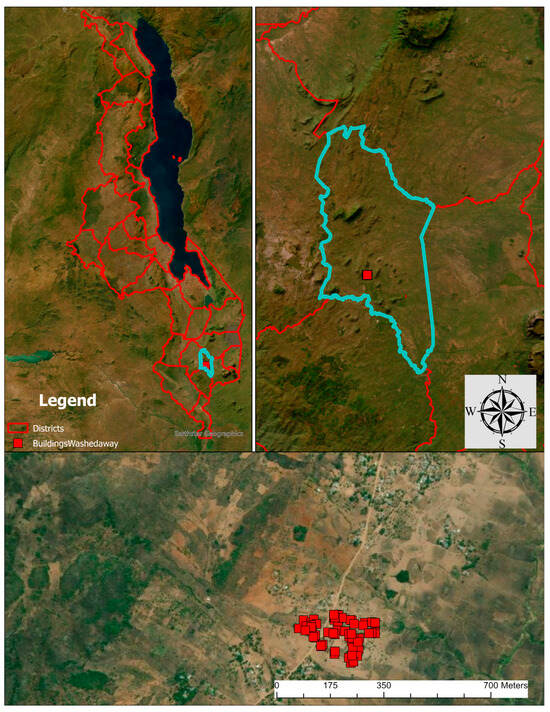
Figure 1.
Study area—Malawi districts (top), Chiradzulu district (lower left), and Mtauchira village (lower right).
The torrential rain and flood events caused by Tropical Cyclone Freddy resulted in multiple landslide events across Southern Malawi on 13 March 2023, causing mass destruction in 13 districts including Chiradzulu [30,31]. When Cyclone Freddy entered Malawi on 12 March 2023, it brought heavy rainfalls and strong winds that led to flash flooding which subsequently triggered landslides over the southern and eastern regions of Malawi [31]. A new record for the highest 24 h rainfall ever recorded was set on March 13th with a total of 459 mm [31]. The Mtauchira village was destroyed by the landslide that fell from Chambe Peak [32,33]. The shallow flow-type landslide started on a steep, deforested slope inducing debris flow expanding to a large area in a very fast speed [31].
The risk of landslides in Malawi is moderate to high due to multiple factors including high annual rainfall, the existence of the tectonically active East African Rift system, complex hydrological networks, susceptible soil, and deforestation [34]. Deforestation has exacerbated the severity of landslides in Malawi as the loss of tree roots erodes the soil, which decreases its ability to retain water [34]. Deforestation is occurring at a rapid pace in Malawi as charcoal is the main fuel source and the rising demand for agricultural land. It is estimated that 33,000 hectares of forest are lost in Malawi every year [34]. This puts Malawi in a dangerous position as its people are cutting trees to survive, but in doing so, this makes their communities more vulnerable to extreme weather events that are only going to intensify because of climate change [34].
Approximately 2.5 million people were affected across Malawi by the cyclone, which included 679 deaths, 537 missing people, 2178 injured people, and 143,487 displaced households [28]. In addition, hundreds of thousands lost their homes, crop, and livestock, and key infrastructure such as roads, schools, power lines, and health facilities were either washed away or severely damaged [30,31]. The combination of the persistent high-water levels, the destruction of infrastructure, crowding of displacement shelters, and the lack of access to safe drinking water also exacerbated the existing cholera emergency [30]. The estimated cost of recovery and reconstruction is USD 680.4 million [31].
Field observations carried out after the event in August 2023 enabled the collection of georeferenced drone images captured by Mavic 3 Enterprise of the landslide that destroyed the Mtauchira village. Figure 2 displays two images of the landslide taken approximately five months after the landslide occurred.
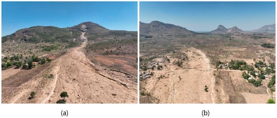
Figure 2.
Drone image of the landslide taken in August 2023 from the bottom of the slope (a) and the top of the slope (b) (source: authors).
2.2. Methods
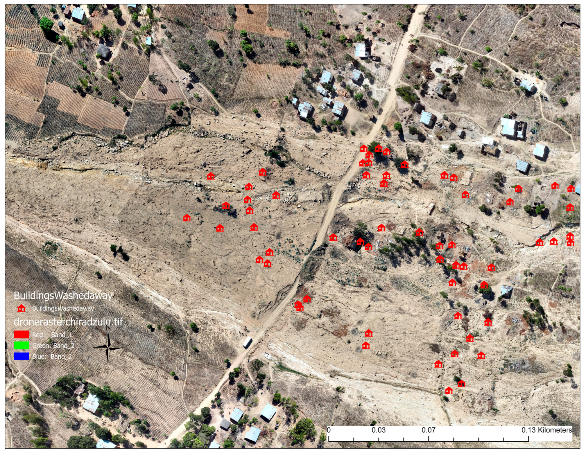
Using ArcGIS Pro (version 3.1), the drone images of the landslide were overlaid onto an existing base map of the area with building footprints depicting the buildings that existed prior to the landslide in red (Figure 3). Many buildings that existed in Mtachuria village before the landslide were washed away in March 2023 as shown in Figure 3.
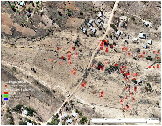
Figure 3.
Map generated from drone images of the landslide impacted area and the location of destroyed buildings with red symbols.
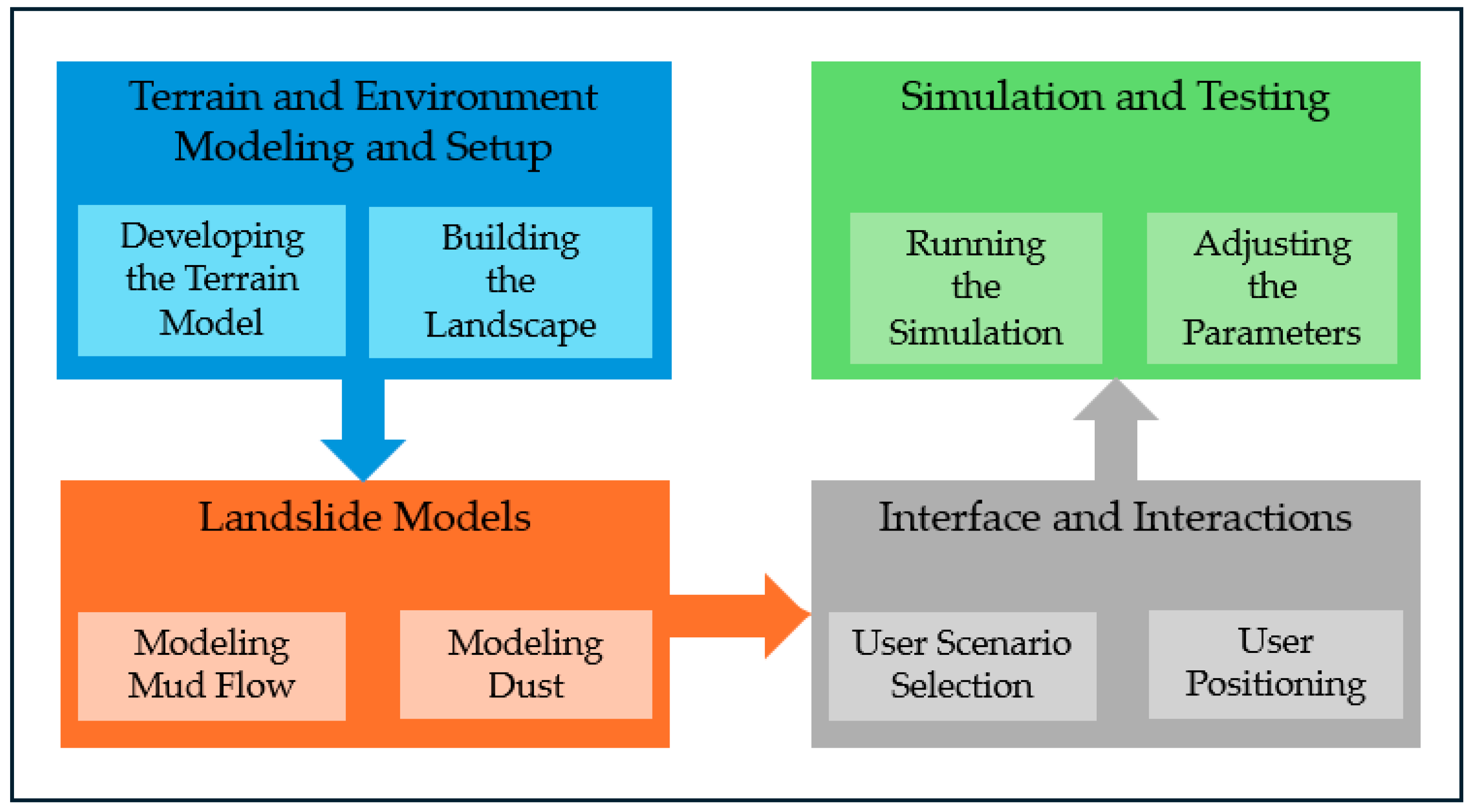
The simulation design was a multifaceted process and can be segmented into four distinct yet interconnected steps. The initial phase involved extensive research and collection of data pertaining to the actual landslide and debris flow events that occurred in Malawi in early 2023. In particular, we focused on type of vegetations, topography, the geographic extent of the actual landslide, type of materials, landslide timeframe, number and type of building damages, role of trees, and vegetation in flow direction. Such real-world data are pivotal to ensuring that the simulation is not only visually accurate but also representative of the actual geophysical processes. Figure 4 shows our workflow for creating the VR application. While there are different methods to model natural hazards such as landslides for virtual reality applications including numeric and non-numeric models, in this study, we use non-numeric approach because our goal is to provide a conceptual understanding of the landslide, educate users about potential impacts of landslides, and how human interventions in the environment (e.g., deforestation) increase the level of vulnerability and damages.
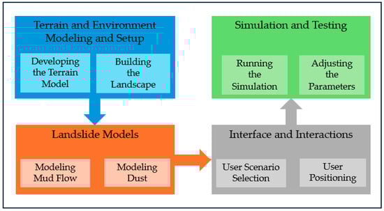
Figure 4.
Methodological framework.
Terrain and Environment Modeling and Setup: Unity3D (version 2022.3.6f1: https://unity.com/), with its robust graphical capabilities, was used to construct high-fidelity terrain representative of the landslide area. This leading game development platform was selected as it offers unparalleled advantages in building interactive 3D, 2D, VR, and AR visualizations. Unity3D’s robust physics engine, adaptability, wide range of supported VR devices, extensive libraries, and sophisticated graphics rendering made it an ideal choice for creating our landslide simulation. Unity is heavily used for VR applications because of its unique VR development capabilities that allows developers to create VR applications with real-world large 3D models for various purposes including training and education.
The foundational data for this simulation came from the terrain height map sourced from Skydark (https://heightmap.skydark.pl/: accessed on 30 July 2023). Using the comprehensive features of Unity3D’s terrain toolbox, this height map was adeptly transformed into a lifelike terrain model within our virtual environment. The landslide simulation was added to the terrain model.
Landslide Model and Visualization: The simulation of the landslide demanded tools with exceptional capabilities. Several Unity capabilities were used to develop a realistic visualization of the landslide that occurred in the study area. Our landslide model consists of mud flow and dust. Particle systems and animation tools were used to develop the dynamic and realistic visualization of the mud flow and dust dispersion on the terrain. Our base landslide model was similar to the actual landslide in terms of the area covered by the mud flow and the damage caused by the landslide. Moreover, the more nuanced and detailed physics-based animations—specifically the intricate models portraying the granular dynamics of debris, rocks, and soil in motion—were deftly fashioned using Blender (version 3.3). Recognized for its prowess in the industry as an open-source tool, Blender became an invaluable asset to our project. In harmonious collaboration, Unity3D and Blender enabled the creation of a landslide simulation that is both aesthetically pleasing and a veritable depiction of the geophysical event.
To enhance the realism and provide a greater learning experience for the end-user, we diversified our simulation scenarios to include three distinct landscapes. This included one featuring a landscape with sparser trees, giving way to a more powerful landslide (close to the actual event situation); another showcasing denser tree coverage that resulted in a mitigated landslide effect; and a final version characterized by an increased prevalence of stones and rocks, simulating their influence on landslide dynamics. This multifaceted approach provides the comprehensive understanding and visualization of how varying landslide scenarios in the Malawian landscape can impact a landslide event. These scenarios were implemented using Unity’s physics such as rigid body and collider systems that enable physics forces and physical boundaries of objects to ensure realistic interactions between debris flow, trees, and buildings.
Interface and Interactions: In this phase of the project, we focused on integrating immersive VR-specific interactions, enabling users to seamlessly navigate, scrutinize, and engage with the simulated environment. More than mere observation, this immersive journey is tailored to offer users an intimate, firsthand experience of the landslide’s unfolding, elucidating its triggers and potential landslide mitigation strategies through slope stabilization with vegetation and reforestation.
To enhance user agency, an intuitive user interface (UI) was implemented. This interface not only facilitates the fluid transition between different simulation scenes but also empowers users to relocate within the environment based on the unfolding scenario or their personal inclinations. Such freedom ensures a dynamic and personalized experience, allowing users to explore various facets of the landslide phenomena in depth.
Simulation and Testing: Once the application components were fully developed, the application went through several tests to make sure that the environment, landslide models, and the interface and user interactive elements function as intended. Adjustments were made in model parameters as needed to enhance the quality and user experience.
3. Results
3.1. VR Application Components
For our simulation, the Oculus Pro VR was selected as the primary VR device. Given the intricacy of the study area environment combined with the high computational demand of landslide physics, a tethered deployment was chosen over mobile VR that allows the VR application in the laptop to be run on the VR device. This decision ensured a consistent and stable frame rate, thereby offering users an uninterrupted and smooth simulation experience.
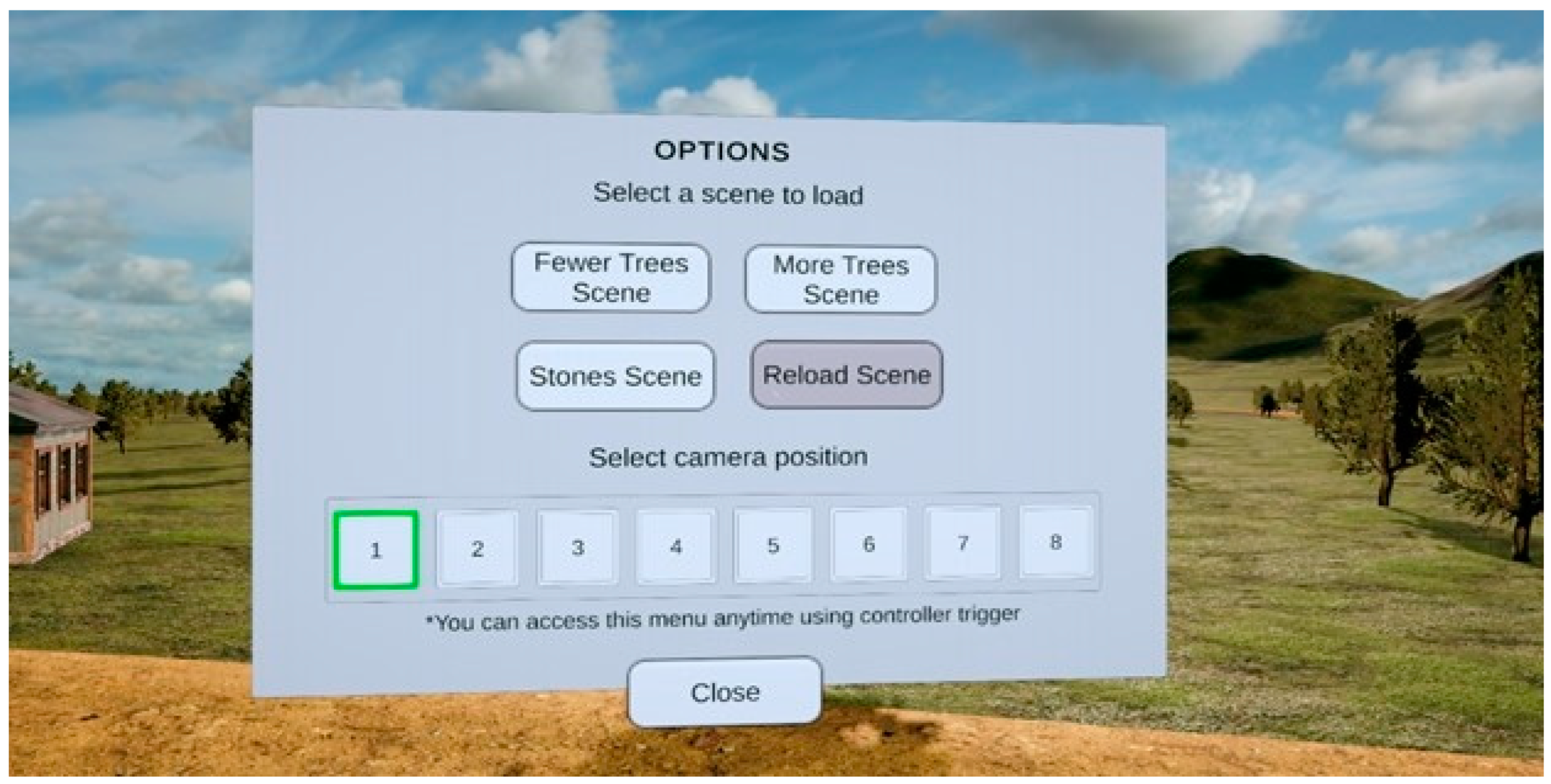
Since the application was crafted to simulate landslide dynamics in three different scenarios with different types of vegetation, a central menu scene was integrated to allow users to toggle between the scenarios. Based on the field investigation, we considered low trees to be the base scenario closely simulating the actual event. Furthermore, to empower users with control over their viewpoint, they also have the capability to start and run the simulation from a predefined location (camera position) within any scenario scene. This immersive interaction was facilitated by an overlay user interface (UI), depicted in Figure 5, with the Oculus hand-held controller serving as the primary input device.
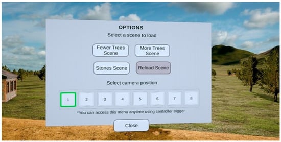
Figure 5.
Interactive user interface displaying scene selection and player positioning options.
3.2. Visualization of the Cyclone-Induced Landslide Event in Virtual Reality
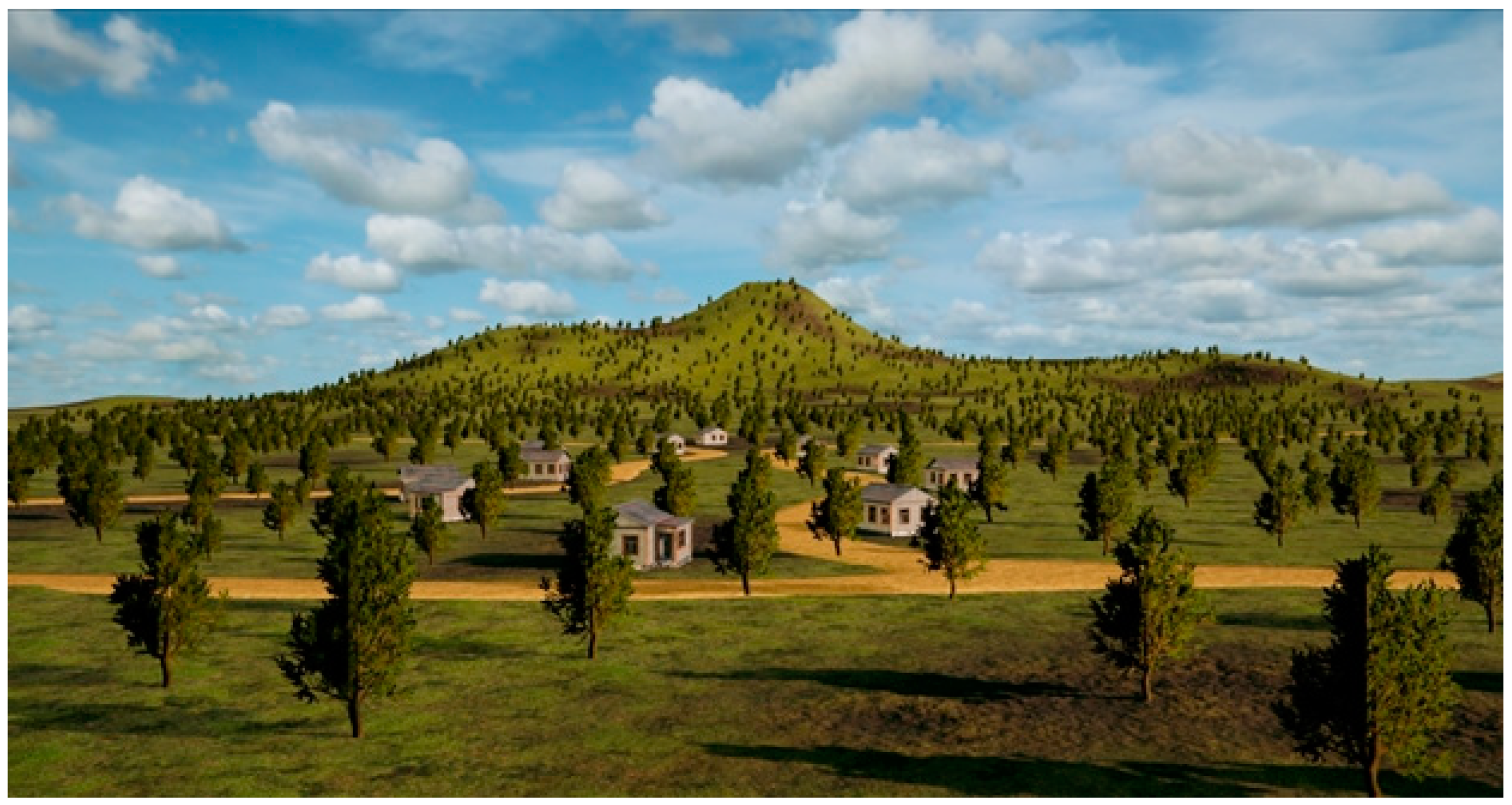
The four interconnected steps of the design framework led to the development of a VR environment that precisely depicts the terrain of the Mtauchira village in Malawi. When a user puts on the Oculus VR headset, they are fully immersed into the environment as shown in Figure 6.
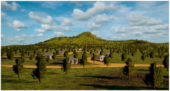
Figure 6.
A glimpse into the virtual representation of Malawi landslide terrain (fewer trees scenario before the landslide event).
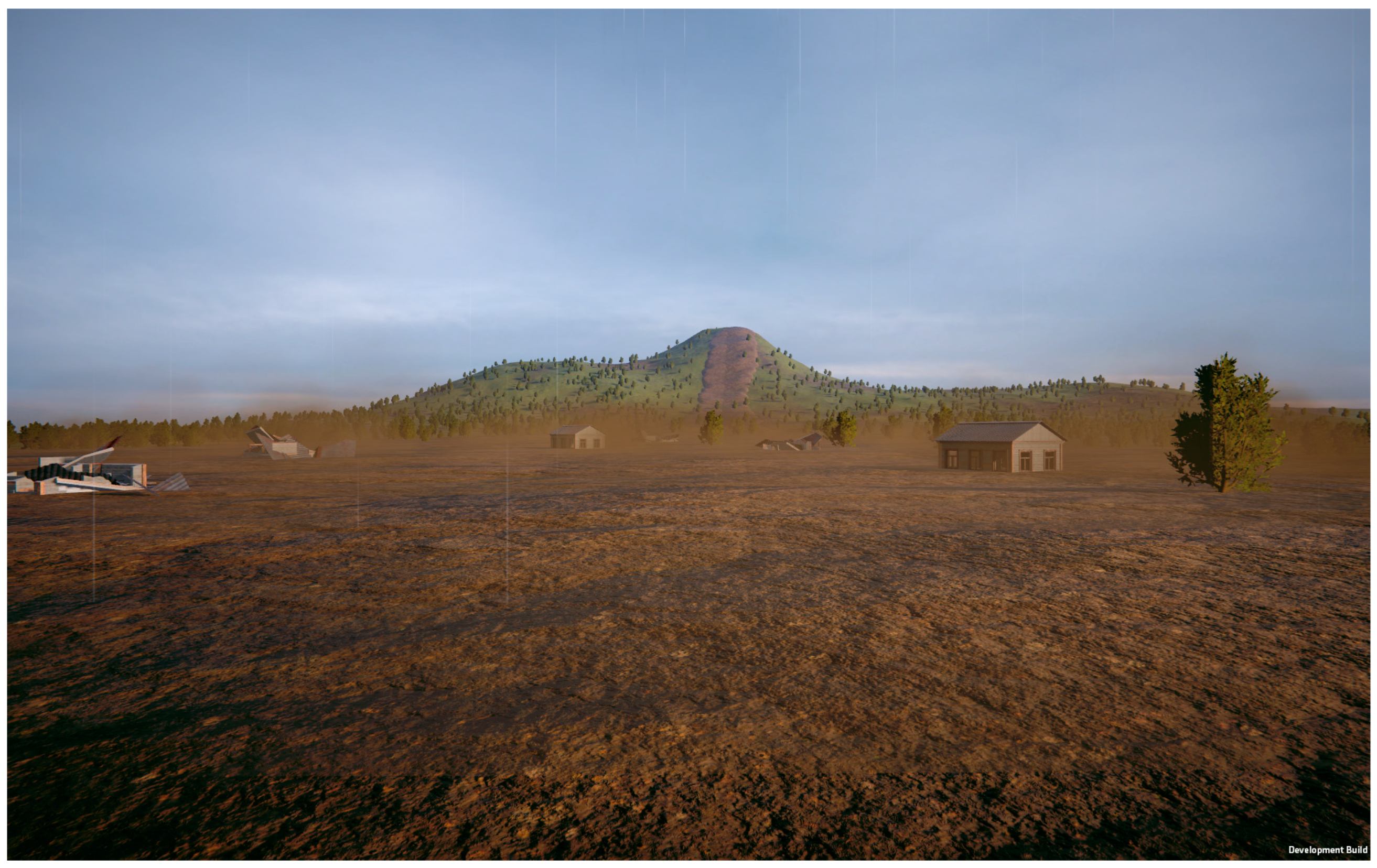
The user can turn and move around and see the entire landscape from different viewpoints. When the user is ready to start the landslide simulation, they can access the main menu located within the simulation (Figure 6). From there, they select the scenario that they want to observe and experience and press the button to start the landslide simulation (Figure 7 and Figure 8).
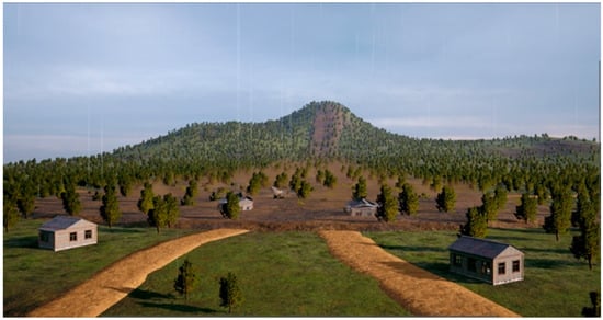
Figure 7.
A screenshot of the landslide simulation (more trees scenario).
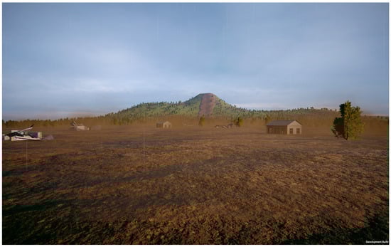
Figure 8.
A screenshot of the landslide simulation (low trees scenario after the landslide event).
3.3. Testing the Usability of the VR Application
To test the usability and capture some initial perceptions of the VR landslide simulation, it was showcased at the Climate Change, Extreme Events, Public Health & Resettlement in Malawi: Public, Policy, Science & Technology Perspectives, Leveraging Deep Learning and Data Science Solutions symposium that was held between 24 and 25 August 2023, in Malawi. Approximately 25 people tried out the VR landslide simulation and provided informal feedback. The VR landslide simulation worked well, and there were many positive comments and perceptions. This included feelings of excitement, a sense of realism, and the creation of a different experience. Some who had experienced the actual landslide found the sound of the landslide in the simulation very realistic.
4. Discussion
Research on the use of VR in the field of disaster and emergency has been gaining momentum over the past five years [1]. Using a real-world example of the landslide that occurred in Malawi early in 2023 during Cyclone Freddy, we created a VR simulation (animation) of the event to be used as an animation of the phenomenon and educational tool.
The ability to acquire an in-depth spatiotemporal understanding through visualization is essential for geohazard education and research. To date, there are some accurate and standardized tools for the visualization of both temporal and spatial geohazards [35]. Typically, digital maps of spatial data on a 2D plane can be visualized and processed by GIS [35]. In addition, GIS and various modeling software can generate 3D views and models of geohazards [35]. While these applications can be used for education, they require the user to be well versed in the software and have sound understanding of the phenomenon being simulated [35]. When compared to looking at digital maps on a 2D plane or 3D views or models using specialized software, VR can enhance spatiotemporal understanding by immersing participations into a 3D environment to allow them to fully visualize and experience a space, even though it is not real. VR simulations are easy to use and do not require any prior expertise to use.
As outlined in the Introduction, studies have shown that VR can be extremely useful in education and training. One of the main advantages of VR for education and training in disaster and emergency management is its ability to simulate real-life scenarios for situations that are either high-risk or dangerous environments or areas that are difficult or impossible to travel to [36]. It is also extremely difficult and expensive to construct natural disaster scenarios, making VR an affordable alternative [36]. Our VR simulation can serve as a dynamic teaching tool on landslides. It can aid in improving students’ understanding of the hazard, the potential impacts of landslides, and how different factors such as terrain can influence these impacts.
There are other potential applications to this VR simulation that can be explored with future research. For example, based on some of the feedback that we received about the sounds of the landslide that can play an important role as an early warning based on traditional knowledge, this could be used to educate people in areas at high risk of landslides on early-warning sounds that may save lives. With VR being able to simulate reality, this can be enhanced to be used for landslide preparedness or response training where participants are put in scenarios that depict real landslide events to see how they would respond and act. The ability to visualize an area in VR could aid in risk assessment and the subsequent development of mitigation strategies such as the placement of early-warning systems, infrastructure placement, and vegetation and drainage improvements. There is also the possibility of turning this simulation into a serious game for learning about landslides and how to mitigate their impact. All these simulations scenarios, if not oversimplified, could facilitate the understanding of landslide events and their causes, development, and improvement in decision-making skills in disaster and emergency management.
Although this is a promising tool for education specific to landslides, there are a few limitations to this work. The first limitation is that this VR simulation was based on a single case study of the 2023 Malawi landslide. To further enhance the understanding of landslides, it would be beneficial to incorporate multiple case studies in future iterations. This could include case studies with different topographic and geophysical characteristics and different triggers (e.g., earthquake, volcano). Another limitation is the size of the application. As we started to make the simulation and environment more realistic, it took up a lot more space that requires more rendering power. Due to the realistic details and the large area of the simulation, it cannot be run without lags on a stand-alone VR device without connection to the laptop at this point. Therefore, a fine balance between the level of details and the size of the study is needed. Capturing a large area with details requires more computational power and VR devices that are able to run them. Last, a comprehensive evaluation of the usability and effectiveness of this VR simulation for educational purposes has not been conducted yet. While informal tests to see if the VR application worked were conducted, a formal evaluation will need to be conducted to gain confidence in the usability and effectiveness of the VR application as an educational tool. It is our plan to conduct these tests as a next step.
Finally, it is important to mention that the application developed here was not based on a numerical model of the landslide, and as such, it does not represent a risk assessment tool and thus cannot be used for structural and engineering interventions (e.g., design of defense structures or the development of early-warning systems). A future enhancement of this application could benefit from a numeric model based on geological, topographical, hydrological, meteorological, seismic, land cover, and human factors. Such numerical models can provide a more data-driven basis for risk mitigation and reduction measures that can be visualized before their implementation [37,38]. While incorporating such models in virtual reality is still challenging, it is expected that with the rapid improvements in VR hardware and software, most of these challenges will be resolved.
5. Conclusions
Modeling and visualization of landslides are typically performed using digital maps, numeric models, and spatial data on a 2D plane or in 3D using GIS and other software tools that often require a level of expertise to understand and use. Although these tools are extremely important for education and research, VR is a promising new and emerging educational and training tool that can complement and enhance the existing offerings. In this study, a VR application of a real and damaging landslide that occurred in Malawi during Cyclone Freddy was developed to be used as an educational and training tool. Using this VR application, users can immerse themselves in a 3D experience where they can explore and interact with a landslide. They can examine different impact scenarios based on the level of vegetation and debris. This educational tool can be used for general knowledge on landslides and learning about how different terrains and human interventions can impact landslide debris flow and damage. Future research and development opportunities exist to enhance this VR tool for application in preparedness, mitigation, and response strategies specific to landslides.
Author Contributions
Conceptualization, A.A.; methodology, A.A. and A.H.; software, A.A. and A.H.; formal analysis, A.A. and A.H.; investigation, A.A. and A.H.; data curation, A.A. and A.H.; writing—original draft preparation, T.C., A.H. and A.A.; writing—review and editing, T.C., A.A. and A.H.; visualization, A.A. and A.H.; supervision, A.A. All authors have read and agreed to the published version of the manuscript.
Funding
VR hardware and software have been funded through ADERSIM and DEXR Lab, project # 40427 funded by the CFI-JELF. The field investigation was partially funded by the Dadaleh Institute for Global Health Research.
Data Availability Statement
The data presented in this study are available on request from the corresponding author.
Conflicts of Interest
The authors declare no conflicts of interest.
References
- Khanal, S.; Medasetti, U.S.; Mashal, M.; Savage, B.; Khadka, R. Virtual and Augmented Reality in the Disaster Management Technology. Front. Virtual Real. 2022, 3, 843195. [Google Scholar] [CrossRef]
- Cipresso, P.; Giglioli, I.A.C.; Raya, M.A.; Riva, G. The Past, Present, and Future of Virtual and Augmented Reality Research: A Network and Cluster Analysis of the Literature. Front. Psychol. 2018, 9, 2086. [Google Scholar] [CrossRef]
- Hamad, A.; Jia, B. How Virtual Reality Technology Has Changed Our Lives: An Overview of the Current and Potential Applications and Limitations. Int. J. Environ. Res. Public Health 2022, 19, 11278. [Google Scholar] [CrossRef] [PubMed]
- Ott, M.; Freina, L. A Literature Review on Immersive Virtual Reality in Education: State of the Art and Perspectives. In Proceedings of the 11th International Conference eLearning and Software for Education, Bucharest, Romania, 23–24 April 2015. [Google Scholar] [CrossRef]
- LaRocco, M. Developing the ‘best practices’ of virtual reality design: Industry standards at the frontier of emerging media. J. Vis. Cult. 2020, 19, 96–111. [Google Scholar] [CrossRef]
- Stanney, K.; Lawson, B.D.; Rokers, B.; Dennison, M.; Fidopiastis, C.; Stoffregen, T.; Weech, S.; Fulvio, J.M. Identifying Causes of and Solutions for Cybersickness in Immersive Technology: Reformulation of a Research and Development Agenda. Int. J. Hum.-Comput. Interact. 2020, 36, 1783–1803. [Google Scholar] [CrossRef]
- Mikropoulos, T.A.; Natsis, A. Educational virtual environments: A ten-year review of empirical research (1999–2009). Comput. Educ. 2011, 56, 769–780. [Google Scholar] [CrossRef]
- Carrión-Mero, P.; Montalván-Burbano, N.; Morante-Carballo, F.; Quesada-Román, A.; Apolo-Masache, B. Worldwide Research Trends in Landslide Science. Int. J. Environ. Res. Public Health 2021, 18, 9445. [Google Scholar] [CrossRef] [PubMed]
- Hungr, O.; Leroueil, S.; Picarelli, L. The Varnes classification of landslide types, an update. Landslides 2014, 11, 167–194. [Google Scholar] [CrossRef]
- Understanding Landslides. Available online: https://www.bgs.ac.uk/discovering-geology/earth-hazards/landslides/ (accessed on 9 December 2023).
- Froude, M.J.; Petley, D.N. Global fatal landslide occurrence from 2004–2016. Nat. Hazards Earth Syst. Sci. 2018, 18, 2161–2181. [Google Scholar] [CrossRef]
- Haque, U.; da Silva, P.F.; Devoli, G.; Pilz, J.; Zhao, B.; Khaloua, A.; Wilopo, W.; Andersen, P.; Lu, P.; Lee, J.; et al. The human cost of global warming: Deadly landslides and their triggers (1995–2014). Sci. Total Environ. 2019, 682, 673–684. [Google Scholar] [CrossRef]
- The Intergovernmental Panel on Climate Change. AR6 Synthesis Report—Climate Change 2023. 2023. Available online: https://www.ipcc.ch/report/ar6/syr/ (accessed on 26 June 2024).
- The Intergovernmental Panel on Climate Change. Special Report—Global Warming of 1.5 °C. 2015. Available online: https://www.ipcc.ch/sr15 (accessed on 26 June 2024).
- Chawla, A.; Pasupuleti, S.; Chawla, S.; Rao, A.C.S.; Sarkar, K.; Dwivedi, R. Landslide Susceptibility Zonation Mapping: A Case Study from Darjeeling District, Eastern Himalayas, India. J. Indian Soc. Remote Sens. 2019, 47, 497–511. [Google Scholar] [CrossRef]
- Das, J.; Saha, P.; Mitra, R.; Alam, A.; Kamruzzaman, M. GIS-based data-driven bivariate statistical models for landslide susceptibility prediction in Upper Tista Basin, India. Heliyon 2023, 9, e16186. [Google Scholar] [CrossRef] [PubMed]
- Fang, Z.; Wang, Y.; van Westen, C.; Lombardo, L. Space-time modeling of landslide size by combining static, dynamic, and unobserved spatiotemporal factors. Catena 2024, 240, 107989. [Google Scholar] [CrossRef]
- Lombardo, L.; Opitz, T.; Ardizzone, F.; Guzzetti, F.; Huser, R. Space-time landslide predictive modelling. Earth-Sci. Rev. 2020, 209, 103318. [Google Scholar] [CrossRef]
- Nocentini, N.; Rosi, A.; Segoni, S.; Fanti, R. Towards landslide space-time forecasting through machine learning: The influence of rainfall parameters and model setting. Front. Earth Sci. 2023, 11, 1152130. [Google Scholar] [CrossRef]
- Lovreglio, R.; Gonzalez, V.; Feng, Z.; Amor, R.; Spearpoint, M.; Thomas, J.; Trotter, M.; Sacks, R. Prototyping virtual reality serious games for building earthquake preparedness: The Auckland City Hospital case study. Adv. Eng. Inform. 2018, 38, 670–682. [Google Scholar] [CrossRef]
- Chen, S.Y.; Chien, W.C. Immersive Virtual Reality Serious Games with DL-Assisted Learning in High-Rise Fire Evacuation on Fire Safety Training and Research. Front. Psychol 2022, 13, 786314. [Google Scholar] [CrossRef]
- León, J.; Gubler, A.; Catalán, P.; Correa, M.; Castañeda, J.; Beninati, G.; Ogueda, A. Assessing potential tsunami vertical-evacuation practices: A study of four cases in Chile using virtual reality and GIS. Int. J. Disaster Risk Reduct. 2023, 98, 104098. [Google Scholar] [CrossRef]
- Zhang, Y.; Zhu, J.; Zhu, Q.; Xie, Y.; Li, W.; Fu, L.; Zhang, J.; Tan, J. The construction of personalized virtual landslide disaster environments based on knowledge graphs and deep neural networks. Int. J. Digit. Earth 2020, 13, 1637–1655. [Google Scholar] [CrossRef]
- Hu, J.; Guo, J.; Xu, Y.; Zhou, L.; Zhang, S.; Fan, K. Differential Ground-Based Radar Interferometry for Slope and Civil Structures Monitoring: Two Case Studies of Landslide and Bridge. Remote Sens. 2019, 11, 2887. [Google Scholar] [CrossRef]
- Pan, J.; Ye, H. Virtual reality and its application to slide animation of landslide. Geo-Spat. Inf. Sci. 2004, 7, 153–156. [Google Scholar] [CrossRef]
- Donati, D.; Stead, D.; Onsel, E.; Mysiorek, J.; Chang, O. Remote Sensing and Geovisualization of Rock Slopes and Landslides. Remote Sens. 2023, 15, 3702. [Google Scholar] [CrossRef]
- Alene, G.H.; Depina, I.; Takur, V.; Perkis, A.; Bruland, O. QuickAware: A virtual reality tool for quick clay landslide hazard awareness. Nat. Hazards 2023, 120, 1869–1898. [Google Scholar] [CrossRef]
- Alene, G.H.; Vicari, H.; Irshad, S.; Perkis, A.; Bruland, O.; Thakur, V. Realistic visualization of debris flow type landslides through virtual reality. Landslides 2023, 20, 13–23. [Google Scholar] [CrossRef]
- National Statistics Office. Malawi 2018 Population and Housing Census Main Report. 2019. Available online: https://malawi.unfpa.org/en/resources/malawi-2018-population-and-housing-census-main-report (accessed on 26 June 2024).
- United Nations Malawi. Tropical Cyclone Freddy Emergency Response Plan. 2023. Available online: https://malawi.un.org/en/228037-tropical-cyclone-freddy-emergency-response-plan#:~:text=This%20plan%20will%20focus%20on,%2C%20roads%2C%20%bridges%20and%20houses (accessed on 26 June 2024).
- Government of Malawi. Humanitarian Situational Analysis Malawi: Inter Agency Assessment Report—March 2023. 2023. Available online: https://reliefweb.int/report/malawi/humanitarian-situational-analysis-malawi-inter-agency-assessment-report-march-2023 (accessed on 26 June 2024).
- Government of Malawi. Malawi 2023 Tropical Cyclone Freddy Post-Disaster Needs Assessment. 2023. Available online: https://preventionweb.net/publication/malawi-2023-tropical-cyclone-freddy-post-disaster-needs-assessment (accessed on 26 June 2024).
- Mtauchira: A Devastating Landslide in Malwa, Triggered by Cyclone Freddy. Available online: https://blogs.agu.org/landslideblog/2023/03/20/mtauchira-1 (accessed on 9 December 2023).
- Cyclone Freddy Become Longest-Lived Tropical Cyclone on Record 2023. FRI Newsletter 31 March CycloneFreddy. Available online: www.frimedia.org (accessed on 26 June 2024).
- Havenith, H.B.; Cerfontaine, P.; Mreyen, A.S. How virtual reality can help visualise and assess geohazards. Int. J. Digit. Earth 2019, 12, 173–189. [Google Scholar] [CrossRef]
- Xie, B.; Liu, H.; Alghofaili, R.; Zhang, Y.; Jiang, Y.; Lobo, F.D.; Li, C.; Li, W.; Huang, J.; Akdere, M.; et al. A Review on Virtual Reality Skill Training Applications. Front. Virtual Real. 2021, 2, 645153. [Google Scholar] [CrossRef]
- Mao, J.; Ma, X.; Wang, H.; Jia, L.; Sun, Y.; Zhang, B.; Zhang, W. Spatio-Temporal Prediction of Three-Dimensional Stability of Highway Shallow Landslide in Southeast Tibet Based on TRIGRS and Scoops3D Coupling Model. Water 2024, 16, 1207. [Google Scholar] [CrossRef]
- Lv, W.; Hu, X.; Li, X.; Zhao, J.; Liu, C.; Li, S.; Li, G.; Zhu, H. Multi-Model Comprehensive Inversion of Surface Soil Moisture from Landsat Images Based on Machine Learning Algorithms. Sustainability 2024, 16, 3509. [Google Scholar] [CrossRef]


Disclaimer/Publisher’s Note: The statements, opinions and data contained in all publications are solely those of the individual author(s) and contributor(s) and not of MDPI and/or the editor(s). MDPI and/or the editor(s) disclaim responsibility for any injury to people or property resulting from any ideas, methods, instructions or products referred to in the content. |
© 2024 by the authors. Licensee MDPI, Basel, Switzerland. This article is an open access article distributed under the terms and conditions of the Creative Commons Attribution (CC BY) license (https://creativecommons.org/licenses/by/4.0/).