Review

Systematic Review of Post-Wildfire Landslides

School of Engineering and Built Environment, Griffith University, Gold Coast 4222, Australia
*
Author to whom correspondence should be addressed.
GeoHazards 2025, 6(1), 12; https://doi.org/10.3390/geohazards6010012
Submission received: 21 January 2025 / Revised: 13 February 2025 / Accepted: 28 February 2025 / Published: 3 March 2025

Abstract

:
This systematic literature review aims to review studies on post-wildfire landslides. A thorough search of Web of Science, Scopus, and other online library sources identified 1580 research publications from 2003 to 2024. Following PRISMA protocols, 75 publications met the inclusion criteria. The analysis revealed a growing interest in research trends over the past two decades, with most publications being from 2021 to 2024. This study is divided into categories: (1) systematic review methods, (2) geographical distributions and research trends, and (3) the exploitation of post-wildfire landslides in terms of susceptibility mapping, monitoring, mitigation, modeling, and stability studies. The review revealed that post-wildfire landslides are primarily found in terrains that have experienced wildfires or bushfires and immediately occur after rainfall or a rainstorm—primarily within 1–5 years—which can lead to multiple forms of destruction, including the loss of life and infrastructure. Advanced technologies, including high-resolution remote sensing and machine learning models, have been used to map and monitor post-wildfire landslides, providing some mitigation strategies to prevent landslide risks in areas affected by wildfires. The review highlights the future research prospects for post-wildfire landslides. The outcome of this review is expected to enhance our understanding of the existing information.

1. Introduction

Many countries, like Australia, Brazil, the USA, Italy, Canada, China, and Greece, as well as other global regions with Mediterranean climates, have experienced higher wildfire activity due to the climate’s effects on the environment [1,2,3,4,5,6], increasing the risk of post-wildfire landslides and mass movement repercussions on nature, building environs [7,8], and human lives [9,10,11,12].
Wildfires span a series of secondary hazards in steep watersheds, including landslides, floods, and debris flow. The rainfall intensity is usually a key triggering factor of landslides and flooding in post-fire conditions for different reasons, including decreased rainfall interception [13,14,15], reductions in ground surface roughness with loss of vegetation, soil hydrophobicity [16], sediment transport to channels and dry ravel [17,18], increased surface runoff rate [19,20], and increases in sediments and discharge yields [21,22]. Wildfires are reported to increase the possibility of landslides by changing the vegetation cover and canopy interceptions [23]; the mechanical, physical, and hydromechanical properties of soils [24,25,26]; weakening plant and tree roots [27,28,29]; and decreasing the root reinforcement strength [30].
Post-wildfire landslides have been well investigated in the literature. Scott [29] has reported many rainfall-induced landslides in regions that had previously experienced wildfires. Several studies have investigated landslides in regions that have burnt for five years or longer [31,32,33,34,35,36,37]. The increase in post-wildfire landslide potentials has been linked to the persistent increase in burned ground moisture after years of wildfires, resulting in decreased evapotranspiration [38]. Additionally, studies have revealed that roots that serve as ground reinforcement can lose their strength due to fires, decreasing the apparent cohesion between the roots and leaving slope areas more vulnerable to failure [39,40,41,42,43]. Intense rainfall events triggered widespread landslides in a roughly 70 km2 area in the San Gabriel Mountains, Southern California, in 2019, especially in areas that had experienced wildfires between three to ten years prior, including the Moris, Colby, and San Gabriel fires in 2009, 2014, and 2016, respectively [44,45]. It was reported that more than 90% of the landslides occurred within the San Gabriel fire areas [46,47,48].
Recent studies have also emphasized how soil characteristics, climate, and wildfire intensity affect the likelihood of landslides. Enhancing prediction models for debris flows and landslides following wildfires has been emphasized in specific research [49,50]. Kean et al. [51] suggested that practical risk assessments and management significantly mitigate the effects of post-wildfire landslide events, including post-wildfire monitoring and burnt ground soil stabilization. Similarly, Santos et al. [52] affirmed that soil stabilization, vegetation restoration, and mitigation are critical to significantly reducing the impact of post-wildfire landslide occurrences. Several studies have been conducted on post-wildfire landslide susceptibility mapping, mitigation, stabilization, monitoring, and modeling. However, despite the research interest in post-wildfire landslides, no systematic literature review has been conducted to identify the advancement and research trends in the field.
This systematic review aims to critically analyze the existing literature by providing a comprehensive systemic review of articles, focusing only on post-wildfire landslides and no other secondary wildfire hazards. The systematic review method provides the basis for further scientific research investigating post-wildfire landslides. In addition, an analysis based on post-wildfire landslides could be widely used in landslide hazards and risk assessment. The review objective was to answer the following questions:
  • What are the current research trends in post-wildfire landslides?
  • What are the existing research gaps in post-wildfire landslides in the literature?
  • What measures are available to mitigate post-wildfire landslides?

2. Systematic Review Methodology

The literature search follows systematic review processes and complies with the PRISMA guidelines. It provides an overview of primary scientific research articles on specific topics that systematically identify, select, assess, and synthesize all that is relevant [53].

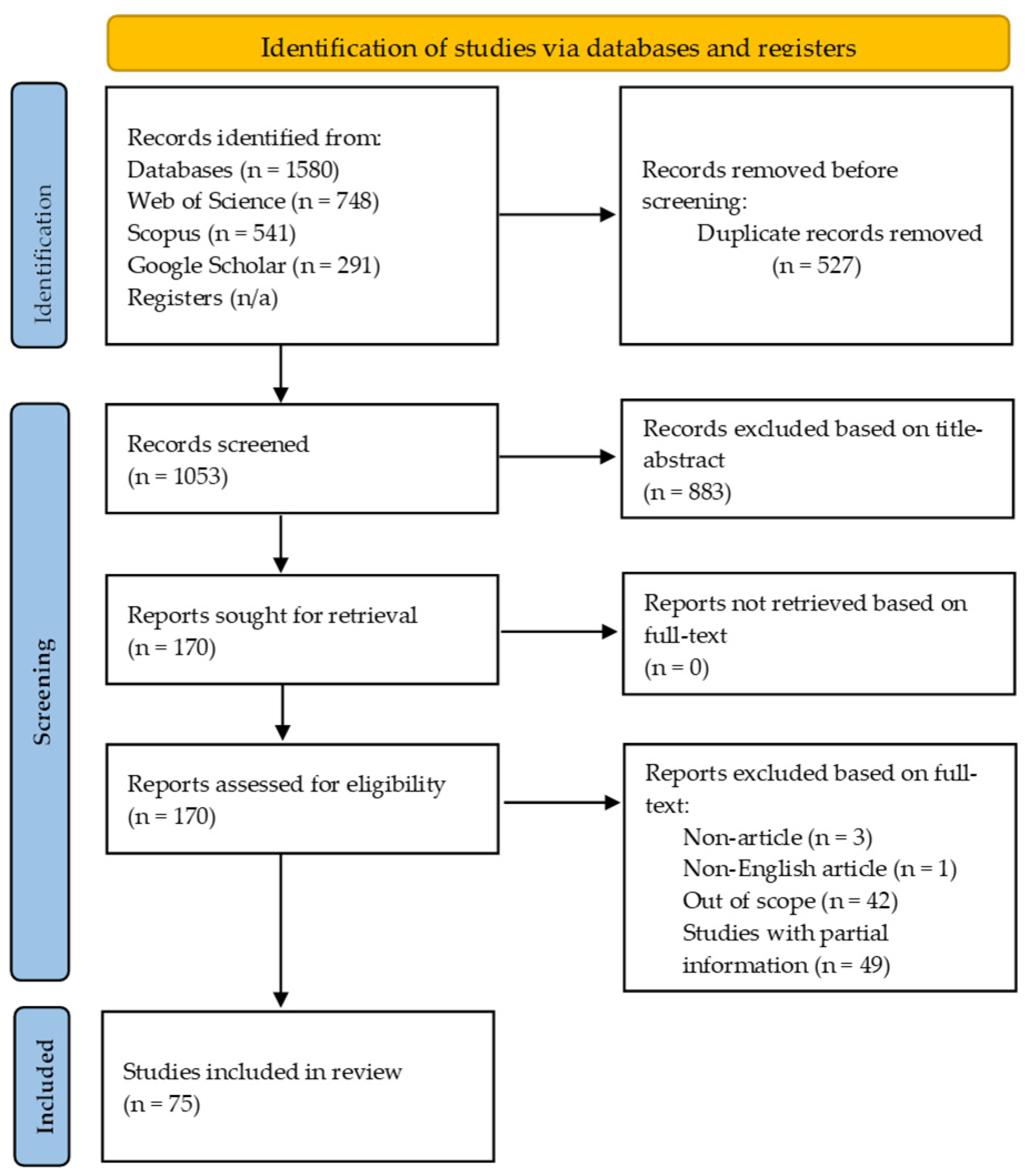
2.1. Literature Search Process

The strategy used widely known bibliographic databases, including Web of Science (WoS), Scopus, Google Scholar, ProQuest, and other sources, to ensure comprehensive coverage of essential literature relevant to post-wildfire landslides. Table 1 profiles the specific search queries for each search domain, ensuring a comprehensive explanation of relevant literature. The search was conducted without restricting the publication year. However, after the search, publications from 2003 to 2024 were obtained. The eligibility criteria that were employed during the search were (1) journal articles specifically published on post-wildfire landslides and not any other topic published on post-wildfire hazards (e.g., debris flow), (2) papers published in the English language only in order to avoid misinterpretations of other languages, (3) papers published in peer-reviewed journals, and (4) grey literature (thus, articles not peer-reviewed were not included in this review study), and (5) unpublished work was not considered. It can be justified that the present review is of a global scale and that WoS and Scopus online library databases have been used, thus ensuring that few research articles in this research area may have been overlooked. In addition, papers published before 2003 and after 2024 were not considered in this study.

2.2. Study Selection Process

Based on the search, 1580 records were found and selected from the above databases. Five hundred and twenty-seven (527) duplicates were eliminated. The title, abstract, and full text of 1053 records were scrutinized. A total of 75 records were recognized as eligible after discarding 978 records, as they did meet the study eligibility criteria (i.e., studies on post-wildfire hazards but not landslides or those mentioning landslides but not explicitly focusing on landslides) after screening using Covidence 2.0 software [54], developed by Covidence in Melbourne Australia. The selection criteria included studies on post-wildfire landslide susceptibility, monitoring, mitigation, modeling, and stability and excluded any other type of landslide research. The review selection procedures are presented in Figure 1 based on the Preferred Reporting Items for Review and Meta-Analysis (PRISMA) protocols [55]. PRISMA is a guideline developed to enhance the process of reporting systematic literature reviews and meta-analyses. In summary, this study reviewed 75 scientific research articles directly related to the topic.

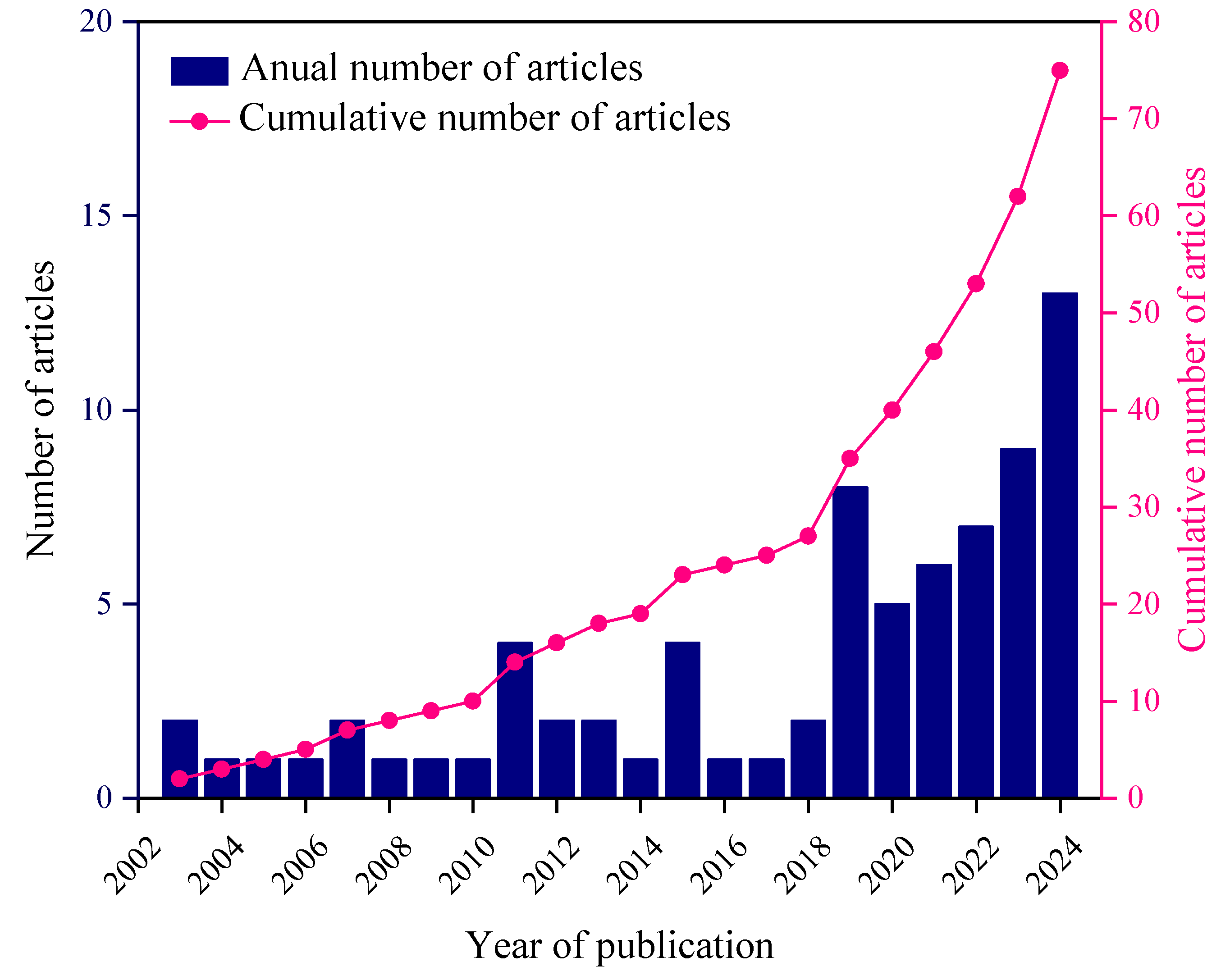
2.3. Publication Information and Types

All 75 articles were published between the years 2003 and 2024. About 36% of the research studies were carried out from 2003 to 2018, after which (i.e., 2019 to 2024) a significant number of studies (64%) were conducted and reported in the literature. In 2024, the highest research number of articles (17%) was published.
All the studies were published as peer-reviewed scientific journal articles (n = 75). They included four conference papers, three book chapters, two review papers, and fifty-one research articles. Figure 2 shows research articles on post-wildfire landslides over the past two decades based on the literature pulled from various databases. The annual number of published articles shows an oscillation trend between 2003 and 2021, then demonstrates an increasing trend from 2022 to 2024, during which 39% of the articles were published. On the other hand, the publications on post-wildfire landslides saw a steady increase (2003–2024).
Figure 3 illustrates the subject area of interest. It is revealed that research studies on post-wildfire landslides cut across the research areas, including “Earth and Planetary Science”, “Environmental Science”, and “Engineering”, which comprise a substantial percentage of the literature. The others (13.2%) include areas such as “Energy”, “Material Science”, and “Chemical Engineering”. This interdisciplinary interest underscores the problematic nature of post-wildfire secondary hazards such as landslides from the perspective of finding the required scientific and practical engineering solutions to post-wildfire landslides and their associated impacts.

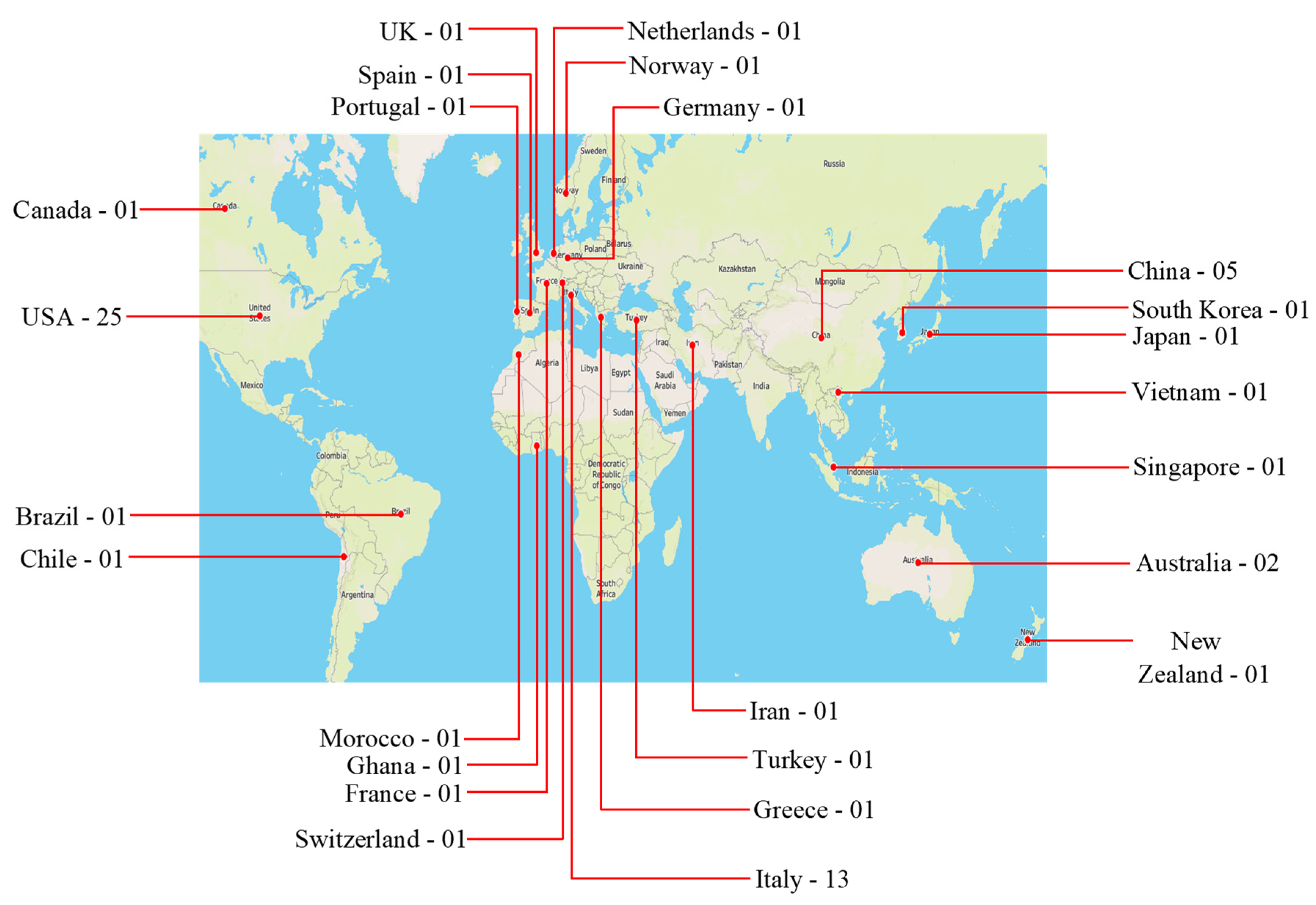
2.4. Geographical Distribution

From the meta-analysis of the 75 research articles in this study, 25 countries were involved in the research on post-wildfire landslides, as shown in Figure 4. As presented in the figure, most research was conducted in the USA (n = 25), Italy (n = 13), Greece (n = 6), Canada (n = 5), China (n = 5), and Australia (n = 2), and other countries, including Germany, Ghana, and the United Kingdom (n = 19). The number of research studies on the topic available across the globe was limited. From Figure 4, few studies have been conducted in Africa, Asia, and Europe compared to America. The figure demonstrates that substantial effort needs to be made in other parts of the world to enhance the knowledge of post-wildfire landslides and associated risks to humans and the environment.

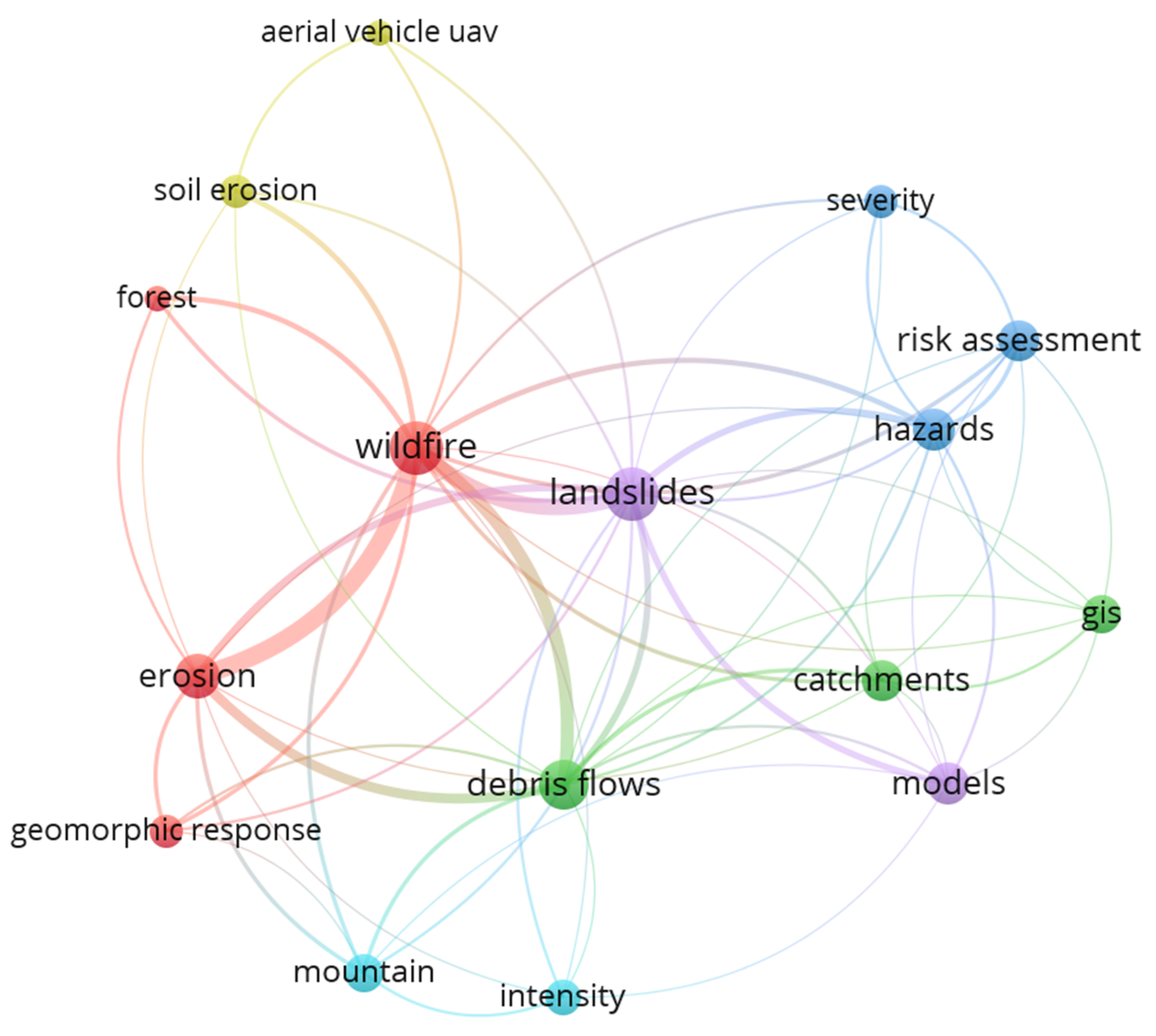
2.5. Keyword Co-Occurrence Analysis

The research articles were further analyzed using VOSviewer software version 1.6.20 [56] to visualize keywords in the co-occurrence cluster network, as shown in Figure 5. Out of the 327 keywords, 26 were selected to meet the minimum frequency of 8. This frequency threshold was used to screen the words and present a clear visualization of the cluster map. To ensure that the results generated were a good reflection of the published articles, the keywords were reviewed and edited to remove words that were not relevant to the topic. This process ensured that the analysis centered on the most pertinent keywords. Keywords removed included “pp”, “gnss”, “ilia”, and “tls”.
Additionally, the names of various countries were removed. Further, closely related keywords were merged. For example, “vegetation growth” was merged to “vegetation” and “landslides” and “shallow landslide” were merged to “landslide”. The node size represents the keyword’s occurrence, and the thickness of the connection links indicates the bond between the keywords within the nodes. It can be seen that wildfire has strong links with “erosion”, “landslides”, and “debris flows”, demonstrating the secondary hazards associated with post-wildfires.
The study focused on “landslide”, which is in connection with “hazards”, “models—development of post-wildfire landslides models for mitigation and stability purposes”, “risk assessments—identifying vulnerable areas, monitoring, and causes and triggers”, and “unmanned aerial vehicle (UAV)—using remote sensing images and datasets to monitor and predict post-wildfire landslide susceptibility”. Keyword relationships aid in identifying subtopics for exploitation, organizing literature, guiding systematic reviews, and enabling a comprehensive analysis of post-wildfire landslide research.

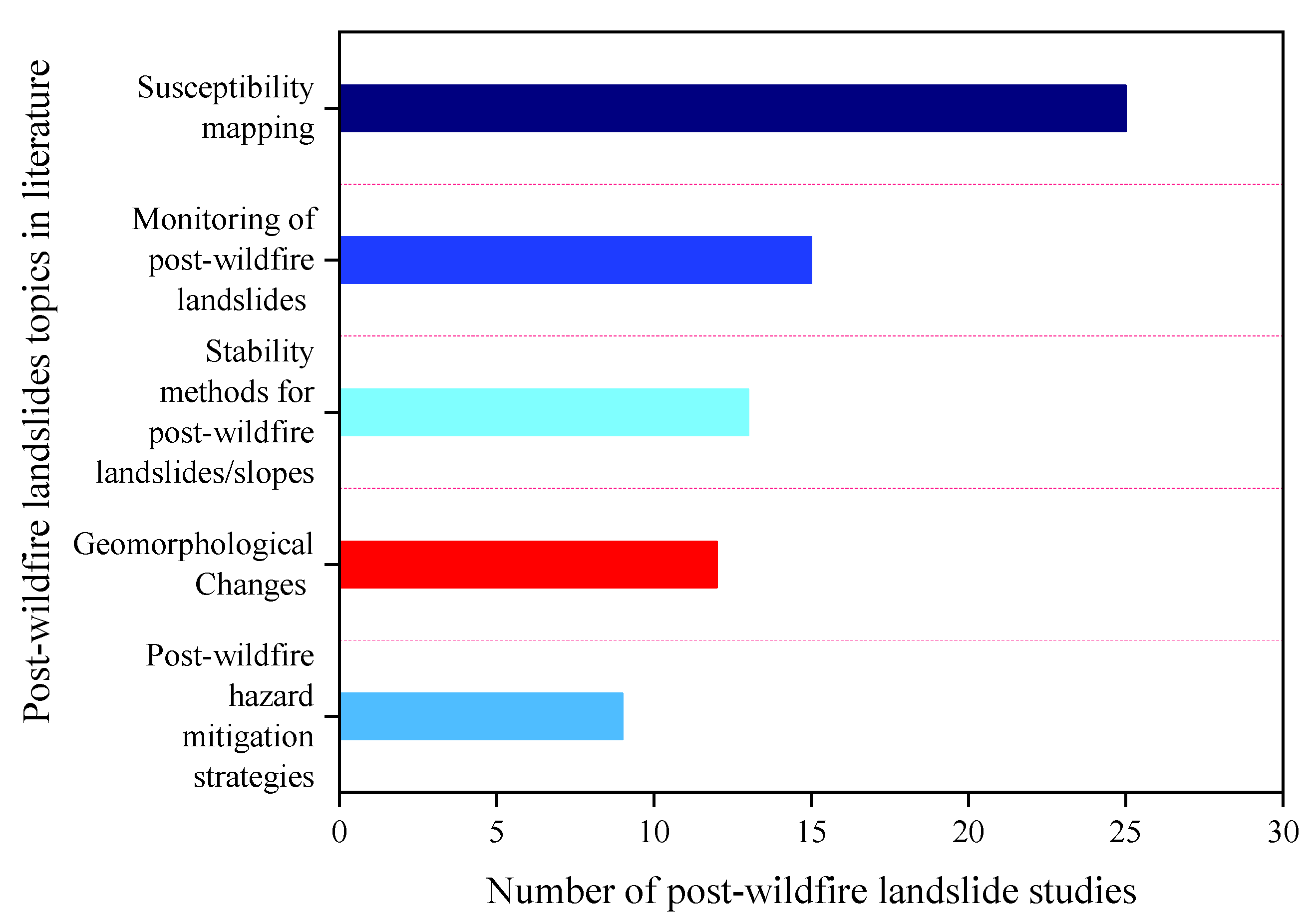
2.6. Characterization of the Selected Research Articles

The selected research articles (75) were characterized based on their contribution to the subtopics. These categorizations were determined from the VOSviewer analysis, emphasizing landslides and considering their susceptibility mapping, monitoring, mitigation, modeling, and stability studies after post-wildfire. The identified subtopics listed below offer a comprehensive framework for exploring the various aspects of post-wildfire landslides and guiding the subsequent discussion of the selected articles. The following subtopics on post-wildfire landslides included in this study are as follows:
  • Susceptibility mapping;
  • Monitoring of post-wildfire landslides;
  • Stability methods for post-wildfire landslides and slopes;
  • Geomorphological changes caused by post-wildfire landslides;
  • Post-wildfire landslide hazard mitigation strategies.
Figure 6 displays the research articles’ distribution across subtopics, indicating varying emphasis in the literature. Significant contributions to specific subtopics indicate their prominence in the research area. For example, articles on post-wildfire landslide susceptibility studies (26), monitoring (15), modeling (12), mitigation (9), and stability (13) were particularly abundant, reflecting their relevance in facilitating informed decision-making and risk modeling hazards associated with post-wildfire landslides. It should be noted that some of the articles overlap within subtopics. Thus, studies with multiple objectives were counted several times, as illustrated in Figure 6—notably, post-wildfire landslide susceptibility, monitoring, prediction, modeling, and mitigation. While the subtopics have common elements, they are kept separate to highlight some specific aspects of this study. These confluences are addressed in descriptions of the subtopics. The systematic literature review focuses on vital key articles and offers significant insight, avoiding some redundancy. This method ensures a concise and thorough examination of essential developments in post-wildlife landslides.

3. Results

The systematic review identified 75 research articles from various areas of the globe outlining distinctive research strands related to studies on post-wildfire landslides. The subsequent sections will explore the subtopics identified from the studies retrieved from different online libraries.

3.1. Exploring the Review Subtopics

The subsequent sub-sections comprehensively review the various subtopics emanating from this systematic literature review.

3.1.1. Susceptibility Mapping of Post-Wildfire Landslide

Traditional methods such as geographic information systems (GIS) and geo-environmental factors [46,57,58], the Moderate Resolution Imaging Spectroradiometer (MODIS), Climate Hazards Group InfraRed Precipitation with Station data (CHIRPS) [59,60], orthophoto and airborne LiDAR data [48], landslide inventory data [61], Landsat-8, Sentinel-1, and environmental factors [62], as well as site information including physical, mechanical and hydrological properties and burn severity assessment [37], have been utilized to study post-wildfire landslides. The susceptibility mapping of landslides has also been studied using different methods, such as machine learning (ML) models with remote sensing data and statistical models [46,63,64]. The prediction of post-wildfire landslide susceptibility with machine learning and remote sensing approaches improves the accuracy and handling of the nonlinear characteristics of datasets. It is cost-efficient compared to traditional methods.
Jackson and Roering [41] investigated post-wildfire geomorphological effects in Oregon using field measurement data and a backpack-mounted Global Positioning System (GPS) and laser ranger finder. The study explored hydrophobic soil behavior, shallow landslide susceptibility, and root reinforcement systems. They observed that wildfires contributed to the changes in the soil structure and vegetation, increasing the possibility of landslides. The study provides valuable insight into exploring post-wildfire landslides. However, it was observed that the study was conducted over a short period, lacking long-term observations of the geomorphic alterations. Additionally, the study’s outcome underscores the physical alterations of the terrain, but predictive methods were not integrated.
Conversely, Di Napoli et al. [63] assessed the post-wildfire landslide susceptibility by focusing on the Camaldoli and Agnano hill terrains in the surrounding city of Naples, Italy. They combined earth-observation datasets and machine learning models, artificial neural network (ANN), generalized boosted model (GBM), random forest (RF), and maximum entropy (MaxEnt) to predict the landslide susceptibility and justify that the combined technique is effective for estimating landslides accurately and precisely, revealing that machine learning and remote sensing methods can capture the complex dynamics of wildfire-affected geological environments. The machine learning and remote sensing model developed may not be applicable in other regions, indicating future research gaps to improve post-wildfire landslide predictions. The researchers suggested that the machine learning model’s performance could be further enhanced using landslide-triggering parameters like rainfall.
In Giampilieri, Sicily, Italy, Trigila et al. [64] employed historical landslide datasets and different environmental factors, including aspect, land cover, and slopes, to predict the post-wildfire shallow landslide susceptibility with logistic regression (LR) and random forest (RF) techniques. They noticed that the RF model outperformed the LR model due to its capability of capturing complex nonlinear relationships in the datasets. They indicated that it is important to evaluate susceptibility maps to ensure high-quality resolution and accuracy due to the temporal alteration of geo-environmental factors, as they significantly impact the model’s performance. Therefore, the maps need to be updated over time. Despite the models’ performances, they are limited to specific study areas and may not be applicable in different areas or allow the use of different model input parameters. Similarly, He et al. [60] used machine learning models, RF, AdaBoost, and Gradient Boost Decision Tree (GBDT), modeled landslide susceptibility in wildfire areas using remote sensing and satellite data as well as anthropogenic and geo-environmental information and predisposing factors. The RF and GBDT models offered better prediction accuracy for landslides than a single conventional model method, but the RF shows superior performance compared to GBDT. The advantage of the models was that they were capable of mapping landslide susceptibility. However, the authors did not consider the uncertainty of the model conditioning factors.
Lainas et al. [61] conducted studies to explore the rainfall thresholds for landslides in western Greece’s wildfire-affected environments. The study focused on 2007 shallow landslides triggered by rainfall to refine prediction models of post-wildfire landslide events. The researchers utilized landslide inventory and rainfall data. The study outcomes revealed that rainfall was essential for triggering landslides in post-wildfire terrains where the vegetation cover and soil properties were affected. It was noticed from the study that rainfall data were only used in the mapped landslide susceptibility, which may limit the study method and cannot be applied to other environmental factors. Peduto et al. [37] observed extreme fire-induced soil hydrophobia and changes in water retention characteristics, increasing landslide risks after investigating volcanic soils from the Saron Mountains in the Campania Region, Southern Italy, following wildfires. It is suggested that the soil composition and texture contributed to post-wildfire landslide susceptibility. Similar observations were reported by [65] after assessing the impact of bushfires on the landslide susceptibility in Otway Range in Victoria, attributing the increased landslide vulnerability to vegetation loss and the alteration of soil properties.
Abdollahi et al. [46] proposed a hydromechanical model based on a physics framework for developing shallow landslide susceptibility maps of rainfall-triggered landslides in environments affected by wildfires. The proposed model used GIS data, unsaturated flow, and root reinforcement, including burn severity with infinite slope stability, to model shallow landslides triggered by rainfall. The hydromechanical model was tested at a burned Southern California site and successfully predicted shallow landslides. Also, the model showed the possibility of slope failure on burned and unburned terrains. Despite the performance of the proposed model [58], the model could benefit from integrating machine learning models and remote sensing datasets to enhance the prediction precision and accuracy when considering different geological environments. Culler et al. [59] evaluated the post-wildfire landslide susceptibility by employing a data-driven method comparing precipitation preceding landslide occurrences globally in pre- and post-wildfire areas. They observed that landslides in post-wildfire areas were often preceded by less rainfall precipitation compared to the areas without burn events, supporting the assumption that wildfires exacerbate the susceptibility to rainfall-induced landslides. Additionally, the study shows regional variations in the seasonality of storms that cause landslides, indicating that wildfires may change the frequency and severity of these occurrences.
Choubin et al. [6] proposed a multi-hazard framework to evaluate the susceptibility to wildfires, floods, drought, and landslides. Their study demonstrated that integrating several hazards enhances risk measurement and mitigation strategies. Additionally, wildfires were closely associated with increasing landslides and flood risks, highlighting the need for thorough risk management tools. Rengers et al. [48] focused on wildfire-induced landslides. They found that the fire intensity significantly influenced the mobility and magnitude of landslides and concluded that landslides happened severely in semiarid Southern California. Post-wildfire landslide susceptibility analyses and mapping have been reported significantly in multiple studies [66,67].

3.1.2. Monitoring of Post-Wildfire Landslide

Monitoring techniques using Landsat-TM, LiDAR, and UAVs [68,69,70,71]; Landsat imagery, Moderate Resolution Imaging Spectroradiometer (MODIS), and Advanced Spaceborne Thermal Emission and Reflection Radiometer Global Digital Elevation Model (ASTE-GDEM) [72]; and GIS technology [73] are used to monitor and detect landslides in environments that have experienced wildfires. UAVs allow for rapid and high-resolution data collection. For example, Deligiannakis et al. [68] introduced UAV-based Structure from Motion (SfM) photogrammetry with terrestrial LiDAR (t-LiDAR) for monitoring and detecting early post-wildfire landslide occurrences that may not be detected by traditional technologies to provide significant insight into geo-environmental changes in real time. The proposed method was reported to be effective in terrains that have experienced intensive wildfires for no more than seven months. The study indicates that t-LiDAR can provide some slope data within areas with minimal vegetation cover. This research highlights the potential of technological advancements in landslide disaster monitoring but may overlook the ecological and community-level influences of post-wildfire landslides.
Using UAV photogrammetry, Graber and Santi [71] developed an advanced technique for monitoring post-wildfire rockfall and slope stability. The investigators proposed an innovative monitoring tool that could assist in providing real-world data used to manage and control landslide risks.
De la Barrel et al. [72] provided an analysis of the 2017 mega-fires in Southern Central Chile, concentrating on the immediate environmental effects. They used remote sensing and air pollution data to evaluate the damage while underscoring the relationship between the fire vicinity and particulate matter levels. The study also assessed the risk of landslide and flooding in the human settlements impacted by the fire. They observed 37 settlements with an intensified risk of floods and landslides using multifaceted datasets. Their study highlights the significance of multiscale monitoring, capturing the immediate and delayed environmental influence of tailored controlling strategies to reinforce ecosystem recovery.
Likewise, as a case study, Carabella et al. [73] explored landslide hazards after the 2017 wildfire in mountainous terrains in Montagna de Morrone, Central Italy. They employed expert-based weighting procedures and GIS-based methods to quantify landslide hazards effectively. The study results show that wildfires increase the risk of landslides, which was confirmed by debris flow triggered by intense rainfall in August 2018. In addition, morphometric analysis, geomorphological field surveys, and GIS were used to identify instability factors and develop thematic maps. They created a new zonation of landslide hazards, which could be applied in civil protection warning systems.
Hope et al. [74] systematically assessed wildfire-affected areas’ natural hazards, including public input and regional knowledge. They developed a robust framework for post-wildfire risk control, identified areas prone to debris flows, and created landslide hazard models. The key findings show that areas affected by wildfires, particularly those with slopy and burned vegetation, experienced a heightened risk of landslides and debris flow, especially after heavy rainfall. Atwood et al. [75] investigated the subsurface hydrological response in burnt basins utilizing electrical resistivity and static water isotope assessment. They reported that wildfires significantly changed the water retention properties of landscapes, impacting the storage and movement of water in soils and underlying bedrock. Additionally, it was revealed that post-wildfire rainfall infiltrates into weathered bedrock, persisting and increasing runoff and infiltration, resulting in increased landslide risks and impacting vegetation regrowth.
Samburova et al. [76] investigated the recent California mega-fires and reported the dynamic changes in the soil hygroscopic and chemical properties. The investigators suggested that the property alterations, especially the abundance of hydrophobic organic compounds, contributed to post-mega-fire soil water repellence that triggered hydrological impacts (i.e., the alteration of soil conditions affected by water), including landslides, debris flows, and floods. In a similar study, Touge et al. [69] employed UAV surveys to monitor and track geomorphological variations caused by wildfires followed by heavy rainstorms in Japan. The research focused on the topographic changes, including post-wildfire landslides, erosion, and the transportation of sediments. They revealed that multi-temporal UAV surveys could capture detailed, high-resolution images of post-wildfire terrain changes with time, providing insight into the effect of heavy rain exacerbating wildfires’ impacts on the landscape. The study also found that wildfires induced the loss of vegetation and soil structure, increasing the risk of landslides and erosion during rainfall. The UAV survey data allow for the precise monitoring of these landscape changes, enabling the identification of vulnerable areas and informing risk management plans.
Dadkhah et al. [77] evaluate the severity of post-fire landslide risks in Ischia, Italy. The study focuses on using the multi-sensor method, incorporating thermal infrared, satellite imagery, and ground-based data, particularly in areas with slopes affected by wildfires. They reported that severe fires degrade the vegetation and soil structure, making the landscape more prone to landslides and erosion when followed by intense rainfall. In order to improve land management techniques and landslide mitigation tactics in susceptible places like Ischia Island, the findings highlight the significance of employing multi-sensor data for monitoring and evaluating post-wildfire risks. Fusco et al. [78] revised the landslide inventory of the Campania region, Italy, including post-wildfire landslides, updating the existing ones to enhance landslide risk monitoring and management control.

3.1.3. Stability Methods for Post-Wildfire Landslides

The stability methods of slopes after wildfires have been studied using analytical and numerical models [46,79] and hydrological properties [80]. The method for improving the stability of landslides after wildfire activities, soil stabilization [81,82,83,84], and vegetation [58,81] have been used to enhance the stability of wildfire-affected areas, especially in steep slope terrains.
Abbate et al. [80] explored the stability of slopes affected by wildfires in mountainous terrains using a combination of field observations, soil properties, and slope stability modeling (i.e., terrain water balance model) to evaluate the correlation between fire-induced alterations and landslide potentials. The study demonstrates that wildfire-induced hydrophobicity, changes in pore pressure dynamics, and vegetation loss are the key factors contributing to slope instability. Araújo Santos et al. [81] explored and evaluated the success of different slope stabilization methods used after wildfire activities in Portugal’s hilly geological terrains, focusing on unmanaged forest areas. The study employs field monitoring, geotechnical analysis, and remote sensing to evaluate the changes in slope stability before and after the intervention. They observed that vegetation restoration, erosion control structures, and soil amendments significantly decrease post-wildfire landslides and their associated risks. However, their efficacy differs with the type of intervention and ecological conditions. Additionally, the study mentioned that while stabilization can mitigate landslide hazards, its long-term efficacy depends on proper implementation and the ability of the landscape to recover from wildfire damage. The study emphasized the significance of reinforcement proactive slope stability management in wildfire-prone areas.
Movasat and Tomac [82] provided valuable descriptions of remedy approaches for post-wildfire slope stability using a laboratory test on xanthan gum-treated hydrophobic sand from wildfire-affected areas and vegetation recovery, focusing on water repellency. The key finding from the study indicated that xanthan gum enhances cohesion and water retention, reducing erosion and mudflow risk. The study outcome indicated that soil amendments enhanced the soil structure and moisture retention in the short term, and vegetation restoration is for long-term slope stabilization. Similarly, Akin et al. [83] reported a stabilization method using xanthan gum and polyacrylamide as stabilizer materials for soil from a post-wildfire environment. After indoor tests, they observed that both polyacrylamide and xanthan gum significantly reduced soil loss and water infiltration, which is opposite to the observation made by [82]. The authors conclude that future research studies should be conducted to determine the optimum rate of each admixture for significant reductions in soil loss and infiltration.
The effect of wildfires on slope stability in forests with a preponderance of European beech trees is examined by Gehring et al. [35]. According to the study, tree roots considerably strengthen the soil, but depending on how resilient the forest is, this reinforcement may be quickly lost following wildfires. The study measured the medium-term evolution of root reinforcement and its impact on slope stability using field data and the Root Bundle Model. The results demonstrate that although low-burn and unburned forests retain their protective potential, moderately burned forests only offer sufficient protection for cohesive, shallow soils, and high-severity fires can eradicate the protective potential for as long as 15 years, thereby raising the risk of landslides for at least 40 years.
Ramirez et al. [85] investigated the effects of the wildfire burn severity and duration on the mechanical and hydraulic properties of forest soils. They used soils from moderate–low-burned, moderate–high-burned, and unburned forests after a March 2022 wildfire to conduct soil strength property tests. The key findings included a significant reduction in the root biomass and soil shear strength in the burned soils compared to those of the unburned soils. Additionally, the study found that the saturated hydraulic conductivity was initially lower in the burned soils due to fine ash-clogged pores and hydrophobic layers but increased over time as macropore flow passages formed, demonstrating the importance of considering the burn severity and post-wildfire time in assessing the soil stability.
Lei et al. [24] examined the hydromechanical properties of soil–root systems over time and their subsequent effects on slope stability within post-wildfire ecosystems in Sichuan Province, China. The research tracked changes in the soil properties, including the shear strength, root density, and permeability, over two years post-fire. The study’s results showed that wildfires cause a significant reduction in the soil cohesion, root density, root tensile strength, and soil root system shear strength due to root death and reduced reinforcement two years after wildfire events. These reductions in soil root systems weaken the soil–root interaction, thus exacerbating the susceptibility to landslides and erosion. Abdollahi et al. [58] investigated the impact of wildfires on the hillslope stability, focusing on unsaturated soil conditions in post-fire terrains. The authors employ a physical-based analytical framework and numerical model to simulate fire-induced alterations in soil properties and near-surface processes. The proposed model revealed that wildfire-induced changes in the hydraulic and mechanical properties of the soil, as well as root reinforcement, significantly reduced the slope stability. Similarly, Abdollahi et al. [79] investigated the impact of wildfires on the occurrence of rainfall-induced landslides. They reported that wildfires could reduce the factor of safety by up to 25%, increasing the risk of shallow landslides. The study integrated hydromechanical infiltration models with infinite slope analysis, including changes in water content, and developed a framework that incorporated wildfire-induced alterations in soil properties and surface processes.
Santos et al. [52] assessed the effect of stabilization methods applied after the October 2017 wildfires in central Portugal. The investigators noted that stabilization methods, including erosion barriers, vegetation restoration, and soil improvements, could significantly reduce erosion and landslide risks in post-wildfire environments as the stabilized slopes exhibited less instability compared to unreinforced slopes. Coppola et al. [86] explored the influence of wooden ember covers (WECs) that were used after wildfires on the soil thermo-hydrological properties and their role in post-wildfire slope stability. The authors conducted experiments employing an outdoor lysimeter filled with pyroclastic silts covered by a 5 cm layer of WECs. They noticed that the wooden ember covers significantly reduced water loss by evaporation, leading to an increased water content in the underlying soil, which could negatively affect the slope stability. The researchers concluded that the barrier effect of the WECs was primarily due to their hydraulic properties, acting as a capillary barrier.

3.1.4. Geomorphological Changes Caused by Post-Wildfire Landslides

The geomorphological changes caused by post-wildfire landslides have been studied using numerical modeling [87,88], field surveys [41,89], and machine learning and landslide inventory, rainfall, and geospatial data [89]. Martin [87] introduced a stochastic wildfire algorithm (a computation method used to simulate and model wildfires) for wildfire occurrence, which was incorporated into a numerical model of drainage basin evolution. The wildfire impact on shallow landslides over millennial time scales in British Colombia was investigated. The model incorporates factors, including soil properties, fire severity, and rainfall patterns, to predict the possibility of landslides over long-term periods. The study revealed that wildfire disturbances significantly increase the magnitude and frequency of shallow landslides over a long period, underscoring the importance of using historical wildfire effects in landscape stability and management.
The post-wildfire geomorphic response across steep forest topography in the Oregon Coastal Range was explored by [41]. They reported that wildfire significantly changes the hydrological and erosion processes of environments affected by wildfires, increasing soil erosion, slope instability, and sediment transport, especially during subsequent rainfall activity. Additionally, the hydrophobic soil layers promote runoff, the initiation of dry ravel, and decreases in root reinforcement, also increasing shallow landslides. The study underscores the significance of understanding the phenomenon for managing post-wildfire landscapes and mitigating landslide risk and erosion.
Shakesby and Doerr [13] explored the impact of wildfires on hydrological and geomorphological processes. They observed that wildfires could directly weather bedrock surfaces and alter soil properties, leading to changes in the soil structure and stability. According to their study, wildfires affect vegetation and soil hydrology, influencing processes including infiltration, overland flow, and erosion, leading to increasing landslides as a result of wildfire-induced soil water repellency.
In the aftermath of the 2007 Southern California wildfires, Ren et al. [88] investigated mudslide risks using scalable and extensible geo-fluid modeling (SEGMENT) to simulate the effects of these slides. The model utilizes soil mechanics, hydrologic processes, and root distributions. The results suggested that the burned areas were more susceptible to the South California mudslides due to the loss of vegetation cover and an increase in the soil moisture content. The study also revealed that future climate activities with significant drought and heavy precipitation could cause more landslides in the study area. The investigators provided a helpful case study highlighting the specific conditions under which the slides were triggered after wildfires. Liu [50] proposed a nonlinear dynamical system model to predict long-, medium-, and short-term slope failure after wildfires. The proposed model could not accurately predict long-term landslides, and the prediction of medium-term landslides posed uncertainty. However, short-term predictions of the timing of landslides may be relatively accurate.
Similarly, Lainas et al. [89] proposed a methodology based on an empirical rainfall threshold model to predict shallow landslides in wildfire-affected terrains in Greece. They used 40 years of daily rainfall data and geological fieldwork in determining the rainfall threshold that triggered landslides. The study found that the model predicted the occurrence of shallow landslides when the cumulative rainfall period was continuous for 6 to 9 days, with local variations according to the terrain’s geological conditions. They suggested that the proposed methodology could serve as the basis for landslide prediction and preliminary hazard evaluation in wildfire-affected areas. Using machine learning, Di Napoli et al. [90] proposed space–time modeling of cascading hazards, including rainfall, wildfires, and landslides, using machine learning. The model effectively improved landslide susceptibility evaluation by integrating wildfire-related predictors, highlighting the significance of multiple hazard considerations. Integrating wildfire intensity and rainfall thresholds in machine learning models enhanced their performance by about 10%. They suggested this method in assessing the risk of landslides, especially in geological terrains that have experienced multiple wildfire disturbances.

3.1.5. Post-Wildfire Landslide Mitigation

Landslide mitigation and the protection of vulnerable regions affected by wildfires are critical to prevent risks and hazards associated with wildfires. A good number of studies have been conducted to improve mitigation measures using advanced technological methods like UAVs [70,71], machine learning and remote sensing methods [90], photographic recordings, fieldwork, and historical data [52]. Some studies have also presented a combination of ecological restoration, engineering solutions, and adaptation management control plans that have been discussed in the literature [91,92,93,94,95].
Notti et al. [70] integrated historical archives and remote sensing data from UAV-LiDAR and Sentinel-2 imagery to improve rockfall mitigation strategies in local communities. The key objective was to create state-of-the-art techniques for designing new rockfall mitigation plans. The study developed a webGIS and three-dimensional interactive view to aid in disseminating rockfall hazards and mitigation strategies to at-risk populations. The outcome could benefit from real-world validation, ensuring its reliability and application in different topographical environments. Graber and Santi [71] examined rockfall occurrences on the natural slopes of Glenwood Canyon after the 2020 Grizzly Creek fires. They used UAV-SfM photogrammetry to monitor four different slopes with different lithologies, and the burn severities over 6 to 18 months were observed. They found five rockfalls during the monitoring period. However, no significant increases in activity after the wildfire events were seen, demonstrating that any wildfire-related effects returned to normal during the monitoring time. The rockfalls detected were spatially correlated with seeps in the slope, winter snowfall, and spring thawing, highlighting that water is a key factor in rockfall events. This study showed the need for effective interventions to mitigate landslide failure.
Wasklewicz et al. [96] explored the increasing risks of landslides and debris flows after wildfires, particularly the Cameron Peak Wildfire in Colorado. The researchers focused on providing engineering solutions to mitigate post-wildfire landslide instability and drainage systems to protect communities and infrastructure. They suggested retaining walls (i.e., large concrete structures and gabion walls), drainage systems, slope stabilization methods, and non-structural strategies, including early warning systems, land-use planning, and public education.
From the studies on the effect of post-wildfire alterations on slope stability, Santos et al. [52] proposed practical and engineering solutions to mitigate the increased risk of landslides after wildfires. They suggested that to mitigate post-wildfire landslides, temporary barriers could be utilized as stabilization measures to promote and enhance soil infiltration, and vegetation cover should also be established to help stabilize the soil and prevent erosion. The study results indicated that simple, cost-effective, and environmentally friendly mitigation measures can reduce the consequences of instability phenomena caused by wildfires. This study emphasizes the significance of timely and suitable mitigation strategies for controlling post-wildfire hazards in hilly areas with unmanaged forests.
Novel methods proposed by Syifa et al. [91] employed hybrid algorithms (SVM-ICA) and remote sensing techniques (Landsat-8 and Sentinel-2 imagery) to investigate post-wildfire landslide mitigation in relation to the Camp Fire wildfire in California, the USA. After training and testing the models, the optimized SVM-ICA model outperformed the unoptimized SVM model with an accuracy of more than 90%, indicating the model’s potential to enhance wildfire damage evaluation and aid in future mitigation strategies. This study provided an essential tool for prioritizing interventions and managing post-wildfire recovery efforts.

4. Discussion

This literature review provides valuable insights into susceptibility mapping, monitoring, stability, geomorphological changes, and mitigation measures associated with post-wildfire landslides and highlights a few challenges discussed below.
Susceptibility mapping. Sustainability mapping is crucial for prioritizing terrains for monitoring and mitigation planning. For this reason, susceptibility mapping has been extensively explored for the past few decades, indicating significant interest in the topic. The practical importance of post-wildfire landslide susceptibility mapping lies in its ability to identify areas at high risk of landslides following wildfires, which is valuable for engineers, practitioners, governments, and decision-makers. Recently, researchers have developed advanced techniques to effectively map and identify landslide susceptibility in environments affected by wildfires [41,60,61,62,63,64]. These advanced technologies, including machine learning and remote sensing, are increasingly utilized in environmental identification, monitoring, and mapping fire-affected landscapes, shifting from traditional GIS and statistical models, as they are cost-effective and less time-consuming. To develop more accurate and practical maps of landslide susceptibility, researchers have also incorporated geotechnical and geomorphological models that include soil properties and environmental factors after wildfires. However, the models available in the literature are case-specific, making them inapplicable to different environments with varying climatic conditions.
Monitoring. It has become a common practice to monitor post-wildfire landslides using advanced remote sensing and conventional monitoring techniques to offer a comprehensive and real-time evaluation of landslide risks [71,72,73]. These technologies, along with field surveys, help to monitor changes in vegetation cover, soil moisture, and landslide occurrences. It is expected that incorporating machine learning models into advanced technologies with remote sensing approaches can provide better monitoring capabilities. Additionally, expanding the scope of post-wildfire geomorphological processes to encompass different topographical and environmental conditions would provide a more comprehensive understanding.
Stability methods. The stability of areas affected by wildfires is compromised due to changes in soil properties and the loss of vegetation, resulting in increased landslides. Analytical and numerical models have been proposed to investigate the stability of areas affected by wildfires, drawing from both practical and theoretical knowledge. Researchers have suggested stability measures for fire-affected environments, including vegetation restoration using biopolymers [82,83] and soil stabilization methods such as gabion walls, temporary barriers, and concrete structures [52]. These simple, cost-effective, and eco-friendly methods can provide stabilization and reduce the consequences of instability caused by wildfire events. However, limited studies have been conducted to evaluate the performance of the stabilization methods applied in post-fire environments [52]. This limitation calls for more field research based on a long-term assessment of stabilization methods used in areas affected by wildfires.
Geomorphological changes. Wildfires induce geomorphological changes, including the formation of hydrophobic soil layers and the removal of protective vegetation. These changes affect the landscape’s hydrological response, increasing the possibility of landslides. The research underscores the necessity of integrated advanced technologies and modeling methods to predict, assess, and mitigate risks associated with wildfire-induced secondary hazards like landslides and mudslides. GIS, remote sensing, machine learning, and numerical simulations can be used to investigate geomorphological changes caused by wildfire events [87,88,89]. However, there is room for more dynamic, real-time models incorporating climate change projections for disaster management. Cross-disciplinary research combining wildfire, geophysical, and climatic models could provide more robust risk assessment frameworks for affected regions.
Mitigation strategies. Studies have provided both theoretical and practical engineering solutions to mitigate the risk of post-wildfire landslides and methods for practical application. The incorporation of advanced technologies such as remote sensing, machine learning, and traditional engineering methods could offer comprehensive approaches to mitigate risks associated with landslides following wildfire occurrences. However, challenges such as cost, accessibility, and the need for expert knowledge have limited the broad application of some methods. Combining technological solutions with traditional practices, such as vegetation restoration and slope engineering, could offer practical and long-term mitigation plans.
Limitations. There are some limitations to take into account: (1) the criteria used in searching and selecting literature on post-wildfire landslide may have excluded some publications that fell outside the search criteria, (2) the restriction of the language to English only may have excluded some publications in other languages with valuable scientific information due to interpretation issues, (3) publications that mentioned wildfire and landslides but did not focus on post-wildfire landslides were excluded.

5. Conclusions

This paper is a comprehensive review of studies on landslides that occurred after wildfires coupled with rainfall activities. The systematic review of the 75 selected research articles highlighted essential subtopics within this domain, underscoring post-wildfire landslide susceptibility mapping, monitoring, stability, modeling, and mitigation methods. The study found that a significant amount of research has been conducted on the subject matter, especially in the USA and Europe, compared to a few studies carried out in Africa and Southern America. It is important to pay close attention to post-fire landslides and their associated risks threatening ecosystems. After reviewing research evidence from the literature, the following conclusions have been drawn:
Post-wildfire landslides are ranked first among the secondary hazards associated with wildfires. The review found that post-wildfire landslides mainly occurred immediately after rainfall, which can lead to multiple forms of destruction, including the loss of life and infrastructure. An interesting topic that has received attention from many researchers is susceptibility mapping, which helps identify landslides in environments after wildfires, followed by monitoring, geomorphological changes, and stability methods. Additionally, theoretical models and computing methods have been proposed and developed for mapping, predicting, and monitoring with remote sensing techniques and machine learning models to study landslides after wildfire events. This provides valuable information for governments and decision-makers to help mitigate post-wildfire landslide risks and hazards.
Future studies should explore further this overlooked research area, including other post-fire hazards like debris flow, flooding, and erosion in environments affected by wildfire activities. The limited number of research publications on the topic, particularly in different countries across the globe, demonstrates the need for more studies. Research should investigate the effectiveness of the proposed models in enhancing the understanding of landslides after wildfires in various terrains.
Future research should focus on the following areas:
  • The models available in the literature for mapping, detecting, and monitoring landslides after wildfire events are region-specific, making them inapplicable in different geological and climatic conditions. Therefore, studies should be conducted to extend the geographical scope, accounting for complex climatic and geo-environmental conditions.
  • More studies such as field experiments should be conducted and other possible environmentally friendly stabilization methods should be employed such as biopolymer, geosynthetic materials, temporary barriers, and natural fibers to stabilize terrains affected by fires and their short-term and long-term effectiveness should be investigated.
  • Studies should be conducted to integrate advanced remote sensing and machine learning approaches to improve landslide susceptibility mapping, prediction, and monitoring in geological environments.
  • Attention should be given to more case studies on the stability and mitigation of post-wildfire landslides, especially on engineering solutions for stability and mitigation, as few case studies have been presented in the literature [52].

Author Contributions

Conceptualization, S.A. and I.G.; writing—original draft preparation, S.A. and I.G.; writing—review and editing, S.A. and I.G.; supervision, I.G. All authors have read and agreed to the published version of the manuscript.

Funding

This research has no funding.

Data Availability Statement

No data are available. All the papers reviewed on this topic can be obtained from online libraries.

Acknowledgments

This research was performed with the financial assistance of the Griffith University Postgraduate Research Scholarship, GUPRS.

Conflicts of Interest

The authors declare no conflicts of interest.

Abbreviations

SVMSupport Vector Machine
ICAImperialist Competitive Algorithm
UAVUnmanned aerial vehicle
GISGeographic information system
ANNArtificial neural network
RFRandom forest
GBMGeneralized boosted model
MaxEntMaximum entropy

References

  1. Nyman, P.; Sheridan, G.J.; Smith, H.G.; Lane, P.N.J. Evidence of Debris Flow Occurrence after Wildfire in Upland Catchments of South-East Australia. Geomorphology 2011, 125, 383–401. [Google Scholar] [CrossRef]
  2. Parise, M.; Cannon, S.H. Wildfire impacts on the processes that generate debris flows in burned watersheds. Nat. Hazards 2012, 61, 217–227. [Google Scholar] [CrossRef]
  3. Jordan, P. Post-wildfire debris flows in southern British Columbia, Canada. Int. J. Wildland Fire 2015, 25, 322–336. [Google Scholar] [CrossRef]
  4. White, R.H.; Anderson, S.; Booth, J.F.; Braich, G.; Draeger, C.; Fei, C.; Harley, C.D.; Henderson, S.B.; Jakob, M.; Lau, C.A.; et al. The unprecedented Pacific Northwest heatwave of June 2021. Nat. Commun. 2023, 14, 727. [Google Scholar] [CrossRef] [PubMed]
  5. Facadio, A.C.; Coelho Netto, A.L.; Macario, K.D.; Ishimine, K.M.; Barth, O.M.; Jou, R. Holocene hillslope evolution through extreme rainfall induced landslides in the mountainous region of Rio de Janeiro, Brazil: Geochronology and paleoenvironmental evidence. Earth Surf. Process. Landf. 2024, 49, 4388–4403. [Google Scholar] [CrossRef]
  6. Choubin, B.; Jaafari, A.; Mafi-Gholami, D. A spatially explicit multi-hazard framework for assessing flood, landslide, wildfire, and drought susceptibilities. Adv. Space Res. 2024, 75, 2569–2583. [Google Scholar] [CrossRef]
  7. Moftakhari, H.; AghaKouchak, A. Increasing exposure of energy infrastructure to compound hazards: Cascading wildfires and extreme rainfall. Environ. Res. Lett. 2019, 14, 104018. [Google Scholar] [CrossRef]
  8. Thompson, M.P.; Calkin, D.E.; Finney, M.A.; Ager, A.A.; Gilbertson-Day, J.W. Integrated National-scale assessment of wildfire risk to human and ecological values. Stoch. Environ. Res. Risk Assess. 2011, 25, 761–780. [Google Scholar] [CrossRef]
  9. Bowman, D.M.; Johnston, F.H. Wildfire smoke, fire management, and human health. EcoHealth 2005, 2, 76–80. [Google Scholar] [CrossRef]
  10. McGuire, L.A.; Rengers, F.K.; Kean, J.W.; Staley, D.M.; Tang, H.; Youberg, A.M. Looking through the window of disturbance at post-wildfire debris flow hazards. In Proceedings of the 7th International Conference on Debris-Flow Hazards Mitigation, Golden, CO, USA, 10–13 June 2019. [Google Scholar] [CrossRef]
  11. Cannon, S.H.; Gartner, J.E.; Parise, M. Wildfire-related debris-flow initiation, Storm King Mountain, Colorado. Geol. Soc. Am. Bull. 2008, 120, 1285–1302. [Google Scholar] [CrossRef]
  12. Smith, H.G.; Sheridan, G.J.; Lane, P.N.J.; Nyman, P.; Haydon, S. Wildfire effects on water quality in forest catchments: A review with implications for water supply. J. Hydrol. 2011, 396, 170–192. [Google Scholar] [CrossRef]
  13. Shakesby, R.A.; Doerr, S.H. Wildfire as a hydrological and geomorphological agent. Earth Sci. Rev. 2006, 74, 269–307. [Google Scholar] [CrossRef]
  14. Moody, J.A.; Shakesby, R.A.; Robichaud, P.R.; Cannon, S.H.; Martin, D.A. Current research issues related to post-wildfire runoff and erosion processes. Earth Sci. Rev. 2013, 122, 10–37. [Google Scholar] [CrossRef]
  15. Vahedifard, F.; Abdollahi, M.; Leshchinsky, B.A.; Stark, T.D.; Sadegh, M.; AghaKouchak, A. Interdependencies between wildfire-induced alterations in soil properties, near-surface processes, and geohazards. Earth Space Sci. 2024, 11, e2023EA003498. [Google Scholar] [CrossRef]
  16. Thomas, M.A.; Rengers, F.K.; Kean, J.W.; McGuire, L.A.; Staley, D.M.; Barnhart, K.R.; Ebel, B.A. Postwildfire soil-hydraulic recovery and the persistence of debris flow hazards. J. Geophys. Res Earth Surf. 2021, 126, e2021JF006091. [Google Scholar] [CrossRef]
  17. Wester, T.B.; Wasklewicz, T.A.; Staley, D.M. Functional and structural connectivity within a recently burned drainage basin. Geomorphology 2014, 206, 362–373. [Google Scholar] [CrossRef]
  18. Palucis, M.C.; Ulizio, T.P.; Lamb, M.P. Debris flow initiation from ravel-filled channel bed failure following wildfire in a bedrock. Geol. Soc. Am. Bull. 2021, 133, 2079–2096. [Google Scholar] [CrossRef]
  19. Moody, J.A.; Ebel, B.A. Infiltration and runoff generation processes in fire-affected soils. Hydrol. Process. 2014, 28, 3432–3453. [Google Scholar] [CrossRef]
  20. Moody, J.A.; Martin, R.G. Measurements of the initiation of post-wildfire runoff during rainstorms using in situ overland flow detectors. Earth Surf. Process. Land. 2015, 40, 1043–1056. [Google Scholar] [CrossRef]
  21. Moody, J.A.; Kinner, D.A. Spatial structures of stream and hillslope drainage networks following gully erosion after wildfire. Earth Surf. Process. Land. 2006, 31, 319–337. [Google Scholar] [CrossRef]
  22. Neary, D.G.; Koestner, K.A.; Youberg, A.; Koestner, P.E. Post-fire rill and gully formation, Schultz Fire 2010, Arizona, USA. Geoderma 2012, 191, 97–104. [Google Scholar] [CrossRef]
  23. Gehring, E.; Maringer, J. Disturbance Calls for Disaster: Why Forest Fires Increase Landslides and Rockfall Hazards. RO 2020, 112, 122–125. [Google Scholar]
  24. Lei, M.; Cui, Y.; Ni, J.; Zhang, G.; Li, Y.; Wang, H.; Liu, D.; Yi, S.; Jin, W.; Zhou, L. Temporal evolution of the hydromechanical properties of soil-root systems in a forest fire in China. Sci. Total Environ. 2022, 809, 151165. [Google Scholar] [CrossRef] [PubMed]
  25. Masi, E.B.; Segoni, S.; Tofani, V. Root reinforcement in slope stability models: A review. Geosciences 2021, 11, 212. [Google Scholar] [CrossRef]
  26. Kean, J.W.; Staley, D.M. Forecasting the frequency and magnitude of postfire debris flows across southern California. Earth’s Future 2021, 9, e2020EF001735. [Google Scholar] [CrossRef]
  27. Staley, D.M.; Negri, J.A.; Kean, J.W.; Laber, J.L.; Tillery, A.C.; Youberg, A.M. Prediction of spatially explicit rainfall intensity–duration thresholds for post-fire debris-flow generation in the Western United States. Geomorphology 2017, 278, 149–162. [Google Scholar] [CrossRef]
  28. Vergani, C.; Werlen, M.; Conedera, M.; Cohen, D.; Schwarz, M. Investigation of root reinforcement decay after a forest fire in a Scots pine (Pinus Sylvestris) protection forest. For. Ecol. Manag. 2017, 400, 339–352. [Google Scholar] [CrossRef]
  29. Scott, K.M. Origin and sedimentology of 1969 debris flows near Glendora, California. U. S. Geol. Surv. Prof. Pap. 1971, 750, 242–247. [Google Scholar]
  30. Benda, L.; Dunne, T. Stochastic forcing of sediment supply to channel networks from landsliding and debris flow. Water Resour. Res. 1997, 33, 2849–2863. [Google Scholar] [CrossRef]
  31. May, C.L.; Gresswell, R.E. Processes and rates of sediment and wood accumulation in headwater streams of the Oregon Coast Range, USA. Earth Surf. Process. Landf. 2003, 28, 409–424. [Google Scholar] [CrossRef]
  32. Meyer, G.A.; Pierce, J.L.; Wood, S.H.; Jull, A.T. Fire, storms, and erosional events in the Idaho Batholith. Hydrol. Process 2001, 15, 3025–3038. [Google Scholar] [CrossRef]
  33. Rice, R.M.; Foggin, G.T., III. Effect high intensity storms on soil slippage on mountainous watersheds in Southern California. Water Resour. Res. 1971, 7, 1485–1496. [Google Scholar] [CrossRef]
  34. Campbell, R.H. Soil Slips, Debris Flows, and Rainstorms in the Santa Monica Mountains and Vicinity, Southern California; US Government Printing Office: Washington, DC, USA, 1975; p. 851. [Google Scholar] [CrossRef]
  35. Gehring, E.; Conedera, M.; Maringer, J.; Giadrossich, F.; Guastini, E.; Schwarz, M. Shallow landslide disposition in burnt European beech (Fagus sylvatica L.) forests. Sci. Rep. 2019, 9, 8638. [Google Scholar] [CrossRef]
  36. May, C.L.; Gresswell, R.E. Spatial and temporal patterns of debris-flow deposition in the Oregon Coast Range, USA. Geomorphology 2004, 57, 135–149. [Google Scholar] [CrossRef]
  37. Peduto, D.; Iervolino, L.; Esposito, G.; Foresta, V.; Matano, F.; Masi, R. Clues of wildfire-induced geotechnical changes in volcanic soils affected by post-fire slope instabilities. Bull. Eng. Geol. Environ. 2022, 81, 454. [Google Scholar] [CrossRef]
  38. Helvey, J.D. Effects of a North Central Washington wildfire on runoff and sediment production 1. J. Am. Water Resour. Assoc. 1980, 16, 627–634. [Google Scholar] [CrossRef]
  39. De Graff, J.V. A rationale for effective post-fire debris flow mitigation within forested terrain. Geoenviron. Disasters 2018, 5, 1–9. [Google Scholar] [CrossRef]
  40. Vahedifard, F.; Williams, J.M.; AghaKouchak, A. Geotechnical engineering in the face of climate change: Role of multi-physics processes in partially saturated soils. IFCEE 2018, GSP 295, 353–364. [Google Scholar] [CrossRef]
  41. Jackson, M.; Roering, J.J. Post-fire geomorphic response in steep, forested landscapes: Oregon Coast Range, USA. Quat. Sci. Rev. 2009, 28, 1131–1146. [Google Scholar] [CrossRef]
  42. Lanini, J.S.; Clark, E.A.; Lettenmaier, D.P. Effects of fire-precipitation timing and regime on post-fire sediment delivery in Pacific Northwest forests. Geophys. Res. Lett. 2009, 36, L01402. [Google Scholar] [CrossRef]
  43. Regelbrugge, J.C.; Conard, S.G. Modeling tree mortality following wildfire in Pinus ponderosa forests in the central Sierra Nevada of California. Int. J. Wildland Fire 1993, 3, 139–148. [Google Scholar] [CrossRef]
  44. Smith, J.; Doe, A. Landslide hazards in the San Gabriel Mountains: The impact of wildfires on post-storm instability. Geophys. Res. Lett. 2019, 46, 215–225. [Google Scholar]
  45. U.S. Geological Survey. Post-Fire Landslides in the San Gabriel Mountains: Impact of the 2009 Morris, 2014 Colby, and 2016 San Gabriel Complex Fires; USGS Circula, U.S. Geological Survey: Reston, VA, USA, 2019; p. 1413. [Google Scholar]
  46. Abdollahi, M.; Vahedifard, F.; Leshchinsky, B.A. Hydromechanical modeling of evolving post-wildfire regional-scale landslide susceptibility. Eng. Geol. 2024, 334, 107538. [Google Scholar] [CrossRef]
  47. Rengers, F.K. Inventory of Landslides Triggered by Rainfall on 16–17 January 2019, Los Angeles County, CA; U.S. Geological Survey: Reston, VA, USA, 2020. [Google Scholar] [CrossRef]
  48. Rengers, F.K.; McGuire, L.A.; Oakley, N.S.; Kean, J.W.; Staley, D.M.; Tang, H. Landslides after wildfire: Initiation, magnitude, and mobility. Landslides 2020, 17, 2631–2641. [Google Scholar] [CrossRef]
  49. Diwakar, K.C.; Naqvi, M.W.; Hu, L. A Case Study and Numerical Modeling of Post-Wildfire Debris Flows in Montecito, California. Water 2024, 16, 1285. [Google Scholar] [CrossRef]
  50. Liu, H.D. Approach to forecasting occurrence of slope failure with nonlinear dynamical system. Appl. Mech. Mater. 2013, 438, 1597–1602. [Google Scholar] [CrossRef]
  51. Kean, J.W.; Staley, D.M.; Lancaster, J.T.; Rengers, F.K.; Swanson, B.J.; Coe, J.A.; Hernandez, J.L.; Sigman, A.J.; Allstadt, K.E.; Lindsay, D.N. Inundation, flow dynamics, and damage in the 9 January 2018 Montecito debris-flow event, California, USA: Opportunities and challenges for post-wildfire risk assessment. Geosphere 2019, 15, 1140–1163. [Google Scholar] [CrossRef]
  52. Santos, L.A.; Coelho, P.; Correia, A. The Effectiveness of Post-Wildfire Slope Stabilization Measures: A Case Study in Oliveira Do Hospital. In Advances in Natural Hazards and Volcanic Risks: Shaping a Sustainable Future, Proceedings of the 3rd International Workshop on Natural Hazards (NATHAZ’22), Terceira Island, Azores, 26–27 May 2022; Springer Nature: Berlin, Germany, 2023; p. 147. [Google Scholar]
  53. Read, G.J.M.; Cox, J.A.; Hulme, A.; Naweed, A.; Paul, M.; Salmon, P.M. What factors influence risk at rail level crossings? A systematic review and synthesis of findings using systems thinking. Saf. Sci. 2021, 138, 105207. [Google Scholar] [CrossRef]
  54. Kellermeyer, L.; Harnke, B.; Knight, S. Covidence. J. Med. Libr. Assoc. 2018, 106, 4. [Google Scholar] [CrossRef]
  55. Page, M.J.; McKenzie, J.E.; Bossuyt, P.M.; Boutron, I.; Hoffmann, T.C.; Mulrow, C.D.; Shamseer, L.; Tetzlaff, J.M.; Moher, D. Updating guidance for reporting systematic reviews: Development of the PRISMA 2020 statement. J. Clin. Epidemiol. 2021, 134, 103–112. [Google Scholar] [CrossRef]
  56. Van Eck, N.; Waltman, L. Software survey: VOSviewer, a computer program for bibliometric mapping. Scientometrics 2010, 84, 523–538. [Google Scholar] [CrossRef] [PubMed]
  57. He, Y.; Beighley, R.E. GIS-based regional landslide susceptibility mapping: A case study in southern California. Earth Surf. Process. Landf. J. Br. Geomorphol. Res. Group. 2008, 33, 380–393. [Google Scholar] [CrossRef]
  58. Abdollahi, M.; Vahedifard, F.; Tracy, F.T. Stability Analysis of Unsaturated Slopes Stricken by Wildfires. In Proceedings of the Geo-Congress, Indianapolis, IN, USA, 6–9 March 2023; pp. 599–609. [Google Scholar]
  59. Culler, E.S.; Livneh, B.; Rajagopalan, B.; Tiampo, K.F. A data-driven evaluation of post-fire landslide susceptibility. Nat. Hazards Earth Syst. Sci. Discuss. 2023, 23, 1631–1652. [Google Scholar] [CrossRef]
  60. He, Q.; Jiang, Z.; Wang, M.; Liu, K. Landslide and Wildfire Susceptibility Assessment in Southeast Asia Using Ensemble Machine Learning Methods. Remote Sens. 2021, 13, 1572. [Google Scholar] [CrossRef]
  61. Lainas, S.; Sabatakakis, N.; Koukis, G. Rainfall thresholds for possible landslide initiation in wildfire-affected areas of western Greece. Bull. Eng. Geol. Environ. 2016, 75, 883–896. [Google Scholar] [CrossRef]
  62. Tien Bui, D.; Shahabi, H.; Mohammadi, A.; Bin Ahmad, B.; Bin Jamal, M.H.; Noor Mohamed, R.B.; Ahmad, A. Land cover change mapping using a combination of Sentinel-1 data and multispectral satellite imagery: A case study of Sanandaj County, Kurdistan, Iran. Appl. Ecol. Environ. Res. 2019, 17, 5449–5463. [Google Scholar] [CrossRef]
  63. Di Napoli, M.; Marsiglia, P.; Di Martire, D.; Ramondini, M.; Ullo, S.L.; Calcaterra, D. Landslide Susceptibility Assessment of Wildfire Burnt Areas through Earth-Observation Techniques and a Machine Learning-Based Approach. Remote Sens. 2020, 12, 2505. [Google Scholar] [CrossRef]
  64. Trigila, A.; Iadanza, C.; Esposito, C.; Scarascia-Mugnozza, G. Comparison of Logistic Regression and Random Forests techniques for shallow landslide susceptibility assessment in Giampilieri (NE Sicily, Italy). Geomorphology 2015, 249, 119–136. [Google Scholar] [CrossRef]
  65. Miner, A.S.; Colls, S. Bushfire impact on landslides in the Otway Ranges, Victoria. In Proceedings of the NZGS Symposium 2021: Good Grounds for the Future, Dunedin, New Zealand, 24–26 March 2021. [Google Scholar]
  66. Vega-García, C.; Chuvieco, E. Applying local measures of spatial heterogeneity to Landsat-TM images for predicting wildfire occurrence in Mediterranean landscapes. Landsc. Ecol. 2006, 21, 595–605. [Google Scholar] [CrossRef]
  67. Yousefi, S.; Pourghasemi, H.R.; Emami, S.N.; Pouyan, S.; Eskandari, S.; Tiefenbacher, J.P. A machine learning framework for multi-hazards modeling and mapping in a mountainous area. Sci. Rep. 2020, 10, 12144. [Google Scholar] [CrossRef]
  68. Deligiannakis, G.; Pallikarakis, A.; Papanikolaou, I.; Alexiou, S.; Reicherter, K. Detecting and Monitoring Early Post-Fire Sliding Phenomena Using UAV–SfM Photogrammetry and t-LiDAR-Derived Point Clouds. Fire 2021, 4, 87. [Google Scholar] [CrossRef]
  69. Touge, Y.; Hasegawa, M.; Minegishi, M.; Kawagoe, S.; Kazama, S. Multitemporal UAV surveys of geomorphological changes caused by postfire heavy rain in Kamaishi City, northeast Japan. Catena 2023, 220, 106702. [Google Scholar] [CrossRef]
  70. Notti, D.; Guenzi, D.; Lasaponara, R.; Giordan, D. Merging Historical Archives with Remote Sensing Data: A Methodology to Improve Rockfall Mitigation Strategy for Small Communities. Land 2022, 11, 1951. [Google Scholar] [CrossRef]
  71. Graber, A.; Santi, P. UAV-photogrammetry rockfall monitoring of natural slopes in Glenwood Canyon, CO, USA: Background activity and post-wildfire impacts. Landslides 2023, 20, 229–248. [Google Scholar] [CrossRef]
  72. De la Barrera, F.; Barraza, F.; Favier, P.; Ruiz, V.; Quense, J. Megafires in Chile 2017: Monitoring multiscale environmental impacts of burned ecosystems. Sci. Total Environ. 2018, 637, 1526–1536. [Google Scholar] [CrossRef]
  73. Carabella, C.; Miccadei, E.; Paglia, G.; Sciarra, N. Post-Wildfire Landslide Hazard Assessment: The Case of The 2017 Montagna Del Morrone Fire (Central Apennines, Italy). Geosciences 2019, 9, 175. [Google Scholar] [CrossRef]
  74. Hope, G.; Jordan, P.; Winkler, R.; Giles, T.; Curran, M.; Soneff, K.; Chapman, B. Post-Wildfire Natural Hazards Risk Analysis in British Columbia: Land Management Handbook; Crown Publication: Victoria, BC, Canada, 2015. [Google Scholar]
  75. Atwood, A.; Hille, M.; Clark, M.K.; Rengers, F.; Ntarlagiannis, D.; Townsend, K.; West, A.J. Importance of subsurface water for hydrological response during storms in a post-wildfire bedrock landscape. Nat. Commun. 2023, 14, 3814. [Google Scholar] [CrossRef]
  76. Samburova, V.; Schneider, E.; Rüger, C.P.; Inouye, S.; Sion, B.; Axelrod, K.; Bahdanovich, P.; Friederici, L.; Raeofy, Y.; Berli, M.; et al. Modification of Soil Hydroscopic and Chemical Properties Caused by Four Recent California, USA Megafires. Fire 2023, 6, 186. [Google Scholar] [CrossRef]
  77. Dadkhah, H.; Rana, D.; Ghaderpour, E.; Ferrarotti, M.; Mazzanti, P. Multi-Sensor Approach to Assessing the Wildfire Severity-Induced Landslide Risk: A Case of Ischia Island, Italy. In Proceedings of the IGARSS 2024-2024 IEEE International Geoscience and Remote Sensing Symposium, Athens, Greece, 7–12 July 2024; pp. 3448–3452. [Google Scholar]
  78. Fusco, F.; Tufano, R.; De Vita, P.; Di Martire, D.; Di Napoli, M.; Guerriero, L.; Mileti, F.A.; Terribile, F.; Calcaterra, D. A revised landslide inventory of the Campania region (Italy). Sci. Data 2023, 10, 355. [Google Scholar] [CrossRef]
  79. Abdollahi, M.; Vahedifard, F.; Tracy, F.T. Post-wildfire stability of unsaturated hillslopes against rainfall-triggered landslides. Earth’s Future 2023, 11, e2022EF003213. [Google Scholar] [CrossRef]
  80. Abbate, A.; Longoni, L.; Ivanov, V.I.; Papini, M. Wildfire Impacts on Slope Stability Triggering in Mountain Areas. Geosciences 2019, 9, 417. [Google Scholar] [CrossRef]
  81. Araújo Santos, L.M.; Correia, A.J.; Coelho, P.A. Post-wildfire slope stability effects and mitigation: A case study from hilly terrains with unmanaged forest. SN Appl. Sci. 2020, 2, 1883. [Google Scholar] [CrossRef]
  82. Movasat, M.; Tomac, I. Evaluation and remediation of post-wildfire slope stability. In E3S Web of Conferences. EDP Sci. 2020, 205, 04007. [Google Scholar]
  83. Akin, I.D.; Akinleye, T.O.; Robichaud, P.R. Changes in Soil Properties over Time after a Wildfire and Implications to Slope Stability. J. Geotech. Geoenviron. Eng. 2023, 149, 04023045. [Google Scholar] [CrossRef]
  84. Roloff, G.J.; Mealey, S.P.; Clay, C.; Barry, J.; Yanish, C.; Neuenschwander, L. A process for modeling short-and long-term risk in the southern Oregon Cascades. For. Ecol. Manag. 2005, 211, 166–190. [Google Scholar] [CrossRef]
  85. Ramirez, R.A.; Jang, W.; Kwon, T.H. Wildfire burn severity and post-wildfire time impact mechanical and hydraulic properties of forest soils. Geoderma Reg. 2024, 39, e00856. [Google Scholar] [CrossRef]
  86. Coppola, L.; Reder, A.; Guido, R.; Tarantino, A.; Pagano, L. Effects of Wooden Embers Cover on Thermo-Hydrological Response of Silty Volcanic Cover and Implications to Post-Wildfire Slope Stability. Eng. Geol. 2024, 341, 107724. [Google Scholar] [CrossRef]
  87. Martin, Y.E. Wildfire disturbance and shallow landsliding in coastal British Columbia over millennial time scales: A numerical modelling study. Catena 2007, 69, 206–219. [Google Scholar] [CrossRef]
  88. Ren, D.; Fu, R.; Leslie, L.M.; Dickinson, R.E. Modeling the mudslide aftermath of the 2007 Southern California Wildfires. Nat. Hazards 2011, 57, 327–343. [Google Scholar] [CrossRef]
  89. Lainas, S.; Depountis, N.; Sabatakakis, N. Preliminary Forecasting of Rainfall-Induced Shallow Landslides in the Wildfire Burned Areas of Western Greece. Land 2021, 10, 877. [Google Scholar] [CrossRef]
  90. Di Napoli, M.; Eroglu, C.; van den Bout, B.; Di Martire, D.; Tanyas, H.; Lombardo, L. Space-time modeling of cascading hazards: Chaining wildfires, rainfall and landslide events through machine learning. Catena 2024, 246, 108452. [Google Scholar] [CrossRef]
  91. Syifa, M.; Panahi, M.; Lee, C.-W. Mapping of Post-Wildfire Burned Area Using a Hybrid Algorithm and Satellite Data: The Case of the Camp Fire Wildfire in California, USA. Remote Sens. 2020, 12, 623. [Google Scholar] [CrossRef]
  92. Sarro, R.; Pérez-Rey, I.; Tomás, R.; Alejano, L.R.; Hernández-Gutiérrez, L.E.; Mateos, R.M. Effects of Wildfire on Rockfall Occurrence: A Review through Actual Cases in Spain. Appl. Sci. 2021, 11, 2545. [Google Scholar] [CrossRef]
  93. Sidle, R.C.; Gallina, J.; Gomi, T. The continuum of chronic to episodic natural hazards: Implications and strategies for community and landscape planning. Landsc. Urban Plan. 2017, 167, 189–197. [Google Scholar] [CrossRef]
  94. Istanbulluoglu, E.; Bras, R.L. Vegetation-modulated landscape evolution: Effects of vegetation on landscape processes, drainage density, and topography. J. Geophys. Res. Earth Surf. 2005, 110, F02012. [Google Scholar] [CrossRef]
  95. Wieczorek, G.F.; Leahy, P.P. Landslide hazard mitigation in North America. Environ. Eng. Geosci. 2008, 14, 133–144. [Google Scholar] [CrossRef]
  96. Wasklewicz, T.; Guthrie, R.; Eickenberg, P.; Kramka, B. Post-wildfire Landslide Engineering: Hazard Assessment to Mitigation in the Cameron Peak Wildfire, Colorado, USA. In International Association for Engineering Geology and the Environment, Chengdu, China, 21–27 September 2023; Springer Nature: Singapore, 2023; pp. 593–612. [Google Scholar]
Figure 1. The systematic review process and search outcome based on PRISMA protocol.
Geohazards 06 00012 g001
Figure 2. Annual and cumulative research articles by year.
Geohazards 06 00012 g002
Figure 3. Publications by subject area of interest.
Geohazards 06 00012 g003
Figure 4. Geographical distribution of studies on post-wildfire landslides.
Geohazards 06 00012 g004
Figure 5. Keyword co-occurrence cluster analysis.
Geohazards 06 00012 g005
Figure 6. Contributions of studies on post-wildfire landslides within subtopics.
Geohazards 06 00012 g006
Table 1. Keywords, limiters, and initial search results for each database searched.
DatabaseSearch Terms and Limiters UsedNumber of Search Results
WoSAB = ((landslides OR wildfires OR burnt OR susceptibility OR mitigation) AND (landslides OR post-wildfire OR fires OR burned OR modeling OR stability OR monitoring)
Refined By Area of Study: Publication Year: All Language: English
748
ScopusTITLE-ABS-((landslides OR wildfires OR burnt OR susceptibility OR mitigation) AND (landslides OR post-wildfire OR fires OR burned OR modeling OR stability OR monitoring)
Refined By Area of Study: Publication Year: All Language: English
541
Google ScholarSearch by article title: Refined By: Publication Year: All
Language: English
291
Disclaimer/Publisher’s Note: The statements, opinions and data contained in all publications are solely those of the individual author(s) and contributor(s) and not of MDPI and/or the editor(s). MDPI and/or the editor(s) disclaim responsibility for any injury to people or property resulting from any ideas, methods, instructions or products referred to in the content.

