Next Article in Journal
The Aspiration for Happy Train Journey: Commuters’ Perception of the Quality of Intercity Rail Services
Next Article in Special Issue
Assessment of Infrastructure Reliability in Expansive Clays Using Bayesian Belief Network
Previous Article in Journal
Water Security in South Asian Cities: A Review of Challenges and Opportunities
Previous Article in Special Issue
Scrutinizing Competitiveness of Construction Companies Based on an Integrated Multi-Criteria Decision Making Model
 
 
Correction published on 30 May 2024, see CivilEng 2024, 5(2), 501.
Article

Assessing the Rainfall Water Harvesting Potential Using Geographical Information Systems (GIS)

1
Faculty of Civil and Environmental Engineering, University of Engineering & Technology Taxila, Rawalpindi 47080, Pakistan
2
James Watt School of Engineering, University of Glasgow, Glasgow G12 8QQ, UK
3
Civil Engineering Department, College of Engineering, Qassim University, Al-Mulida 51431, Saudi Arabia
4
Department of Civil Engineering, International Islamic University, Islamabad 44000, Pakistan
5
Civil Engineering Department, IBADAT International University, Islamabad 46000, Pakistan
*
Authors to whom correspondence should be addressed.
CivilEng 2022, 3(4), 895-908; https://doi.org/10.3390/civileng3040051
Submission received: 8 August 2022 / Revised: 29 September 2022 / Accepted: 30 September 2022 / Published: 12 October 2022 / Corrected: 30 May 2024
(This article belongs to the Special Issue Next Generation Infrastructure)

Abstract

:
Water scarcity is a major issue for developing countries due to the continuous increase in population every year, the major environmental challenges faced by developing countries such as Pakistan being the scarcity of water. One proposed solution to meet the requirements is to conserve water from rainfall. The process consists of the collection, storage, and use of rainwater. The rooftop rainwater harvesting systems (RWH) and rainfall harvesting system for artificially recharged water by recharge wells have received increased attention in the recent past as an efficient means of water conservation. In this study, both the systems have been analyzed for the University of Engineering and Technology Taxila (UET Taxila), Pakistan. The objective of this study is to propose a system to harvest water from the rooftops of all of the buildings on the campus and also to propose the most optimum locations of recharge wells for the artificial recharge of groundwater development. Numerous field visits were conducted after every rainfall over the past few months to identify lower elevation areas, which were further validated by the results obtained by Arc GIS. The total area of catchments available for rainwater harvesting in UET Taxila and the amount of water that could be harvested or used for replenishing groundwater reserves were also assessed in the current study. The results show that the harvestable rooftop water per month is 59% of the currently available source for watering trees and plants, and the harvestable water by recharge wells is 761,400 ft3 per year.

1. Introduction

Water is the most essential component of life on Earth [1]. About 70% of the Earth’s surface consists of water, but less than 1% of this water is easily accessible to fulfill human needs [2]. The demand for water has been increasing worldwide due to demographic changes, socioeconomic factors, changes in agricultural practices, and climatic variations [3,4]. On the other hand, increasing demands for water for irrigation purposes have led to the expansion of groundwater irrigation systems in many countries [5]. Pakistan is a developing country that has been facing water scarcity over the last two decades. Groundwater is the main source of human and agricultural needs, where the annual increase in industrial and domestic water demand is 10% [6,7,8].
The potential increase in demand from municipal, industrial, and agricultural areas for groundwater has raised questions regarding the sustainability of groundwater [9]. In Pakistan, more than 50% of the irrigation requirement is provided by groundwater [10]. The groundwater abstraction rates have increased to 60 km3, exceeding the annual recharge rate of 55 km3 [11]. Khan et al. (2008) showed that if there is no sustainable groundwater development in the region, a 10–20 m decline in groundwater levels is probable in the upper and lower regions of Pakistan [12]. In the recent past, Wada et al. (2010) identified many points of groundwater depletion in different regions of the world, with the highest depletion rates being in North-East Pakistan [13].
Rooftop rainwater harvesting systems (RWHs) are a traditional form of water supply in rural areas, but recently, they have also been applied to supplement urban water supply due to the growing demand for water in many urban regions [14,15,16]. The typical RWH system provides dual benefits of water supply increase and storm-water retention, which have been widely recognized and analyzed through modeling and empirical studies [17,18,19,20,21,22]. RWH systems are not only useful for drinking water, but are also an essential component of social, economic, and environmental spheres of user livelihood, communities, and ecosystem generation, and maintenance [23,24,25,26,27]. The performance of site-scale rainwater tank systems and storm-water retention behavior has been assessed by Xu et al. [28]
In the last few decades, RWH has regained importance as a holistic approach for sustainable growth [1,4,23]. Rainfall harvesting increases the availability of groundwater and raises the water levels in wells and tube wells, controls flood and droughts, and supplements the requirement of water for domestic use; reduces soil erosion, silting, and contamination of waterways from polluted surface runoff; and reduces the flow of stormwater and minimizes the chances of overloading of the drainage system [1]. Rainfall harvesting can be done by digging ponds and tanks, building embankments and check dams, constructing concrete underground reservoirs, and constructing recharge bores and recharge pits. GIS is a very effective tool, where layered information from different thematic maps can be integrated for use in identifying the potential zones [29,30,31,32,33,34].
A study in the United Kingdom showed that without considering the quality of the infiltrated water, it may cause negative effects on human health [35]. In a few countries such as South Africa, rainfall harvesting is illegal due to local constraints [36]. In many other countries, rainfall harvesting has been promoted to achieve the maximum benefit of rooftop and infiltrated water. However, there are few constraints in promoting rainfall the harvesting system, including the absence of rainfall harvesting laws regarding the water policies of many countries, especially underdeveloped countries [37], as it should be part of the national water management plan, as it has already been done in various countries such as Germany and Australia [38]. Underdeveloped countries have serious concerns about financial constraints when developing a rainfall harvesting system at a local level, as it requires a higher installation cost [39]. In addition to all of these factors, lack of awareness in the community is the prime hurdle to overcome when promoting this system [40].
Pakistan is an agrarian country where almost 70% of the population directly depends on the agricultural yield. As a result of Pakistan’s arid and semi-arid climate, agriculture depends greatly on irrigation water supplies from canals and groundwater. However, there has been a gradual decline in surface water supplies, with a 15% decrease over the past two decades. The surface water supply is not only becoming deficient, but it has also become spatiotemporally unavailable in many parts of the Indus Basin. Regarding surface water supplies, the Indus Basin is considered to be the most depleted river basin in the world [41]. While the demand for irrigation is increasing due to agricultural intensification, the supply is unlikely to increase from surface water resources. It is estimated that the domestic and industrial water demand is growing at an annual rate of 10% in Pakistan [42]. Hence, there has been a substantial increase in the utilization of groundwater resources to sustain agricultural productivity as inter-sectoral competition is increasing. Pakistan meets more than 50% of its overall irrigation requirements through groundwater abstractions, which has raised concerns about the sustainability of groundwater resources in the region [43]. Previously, studies have shown that because of climate change conditions, there will be a 10–20 m decline in groundwater levels in the upper and the lower region of Rachna Doab in North-East Pakistan [44]. Research has identified various hot spots of groundwater depletion in different regions of the world, with the highest depletion rates being found in North-East Pakistan and North-West India [45]. Based on the aforementioned evidence, there is an immense requirement to promote and develop rainfall harvesting systems at local and national levels for sustainable surface and subsurface water resources in countries such as Pakistan. The objective of this study is to propose a system to harvest water from the rooftops of all of the buildings at the University of Engineering and Technology Taxila, Punjab, Pakistan. Field surveys were conducted to outline the campus and propose the optimal locations for recharge wells for artificial groundwater recharge development.

2. Materials and Methods

2.1. Study Area

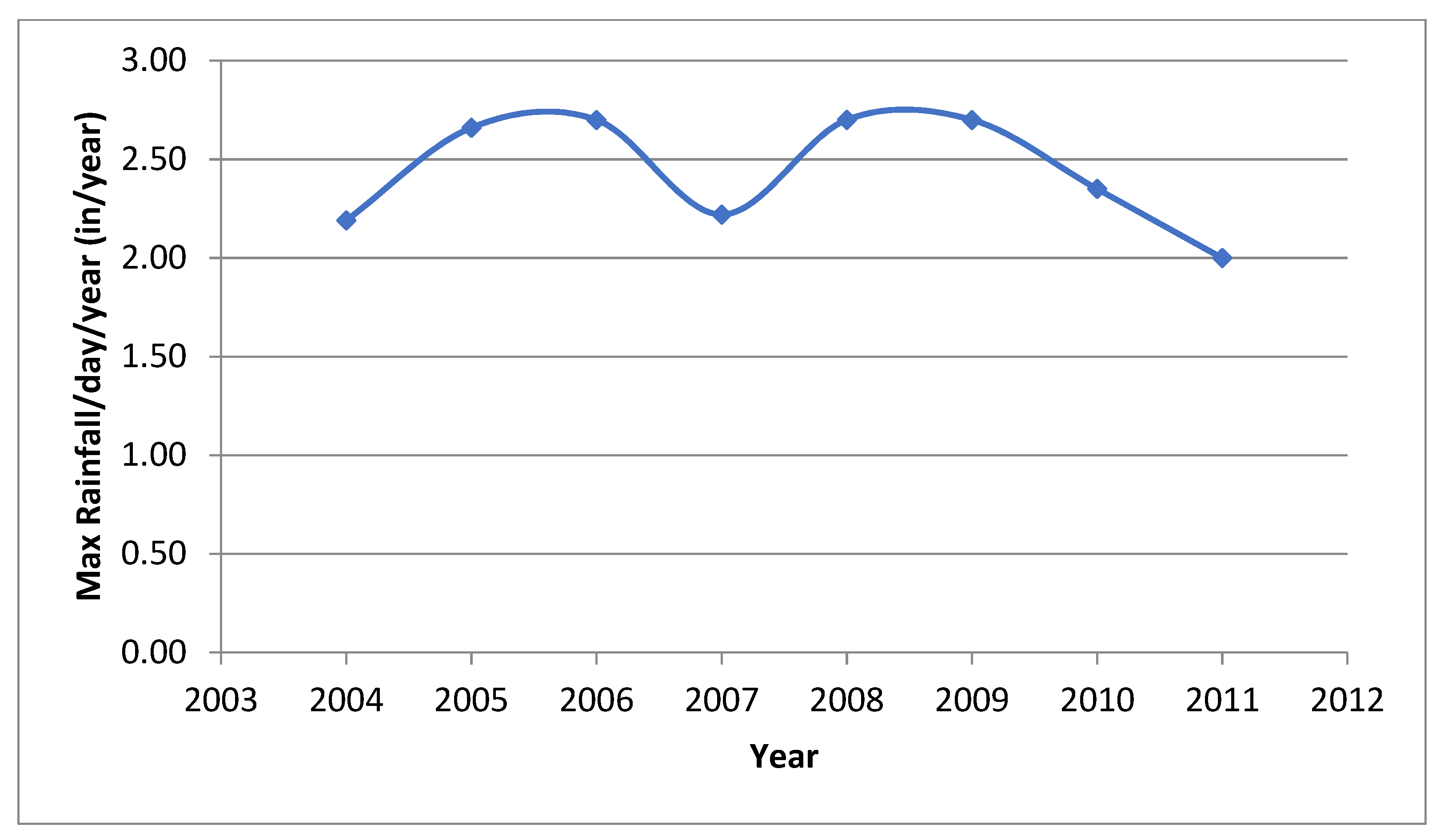
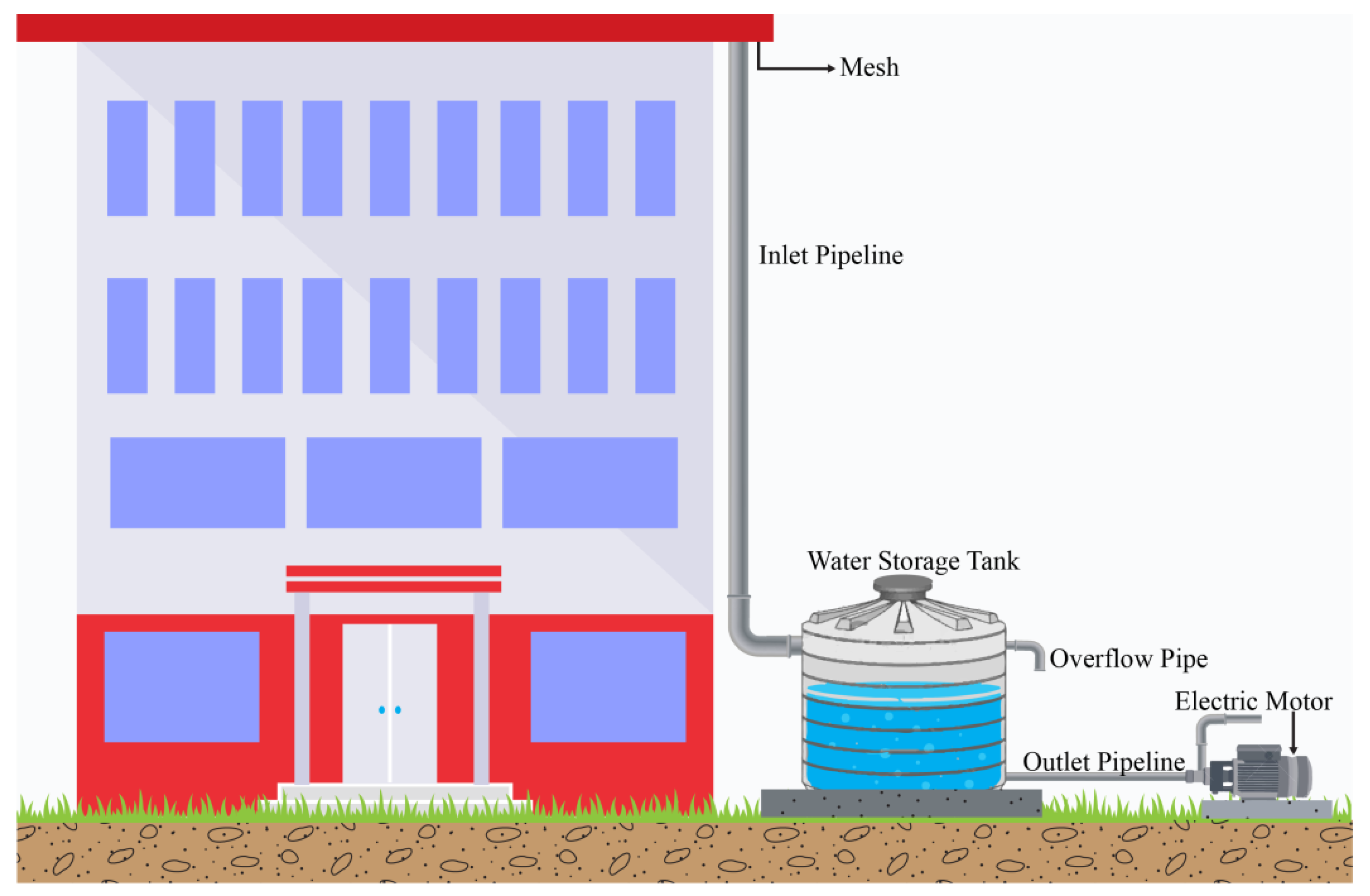
The study area is the UET Taxila, located at 33.7670° N, 72.8235° E, as shown in Figure 1. The entire area is about 160 acres (6,973,330 ft2), which includes green belts, residential buildings, departments, playgrounds, cafeteria, hostels, and mosques, etc. The rooftop area of 19 different buildings was used to estimate the total harvestable water from the top of the roofs. This harvestable water could be stored in storage tanks for further use for horticulture purposes. The design of the storage tanks depends on the maximum rainfall per day per year and the area of a specific roof. The maximum rainfall per day per year is shown in Figure 2. The schematic diagram of the system is shown in Figure 3.
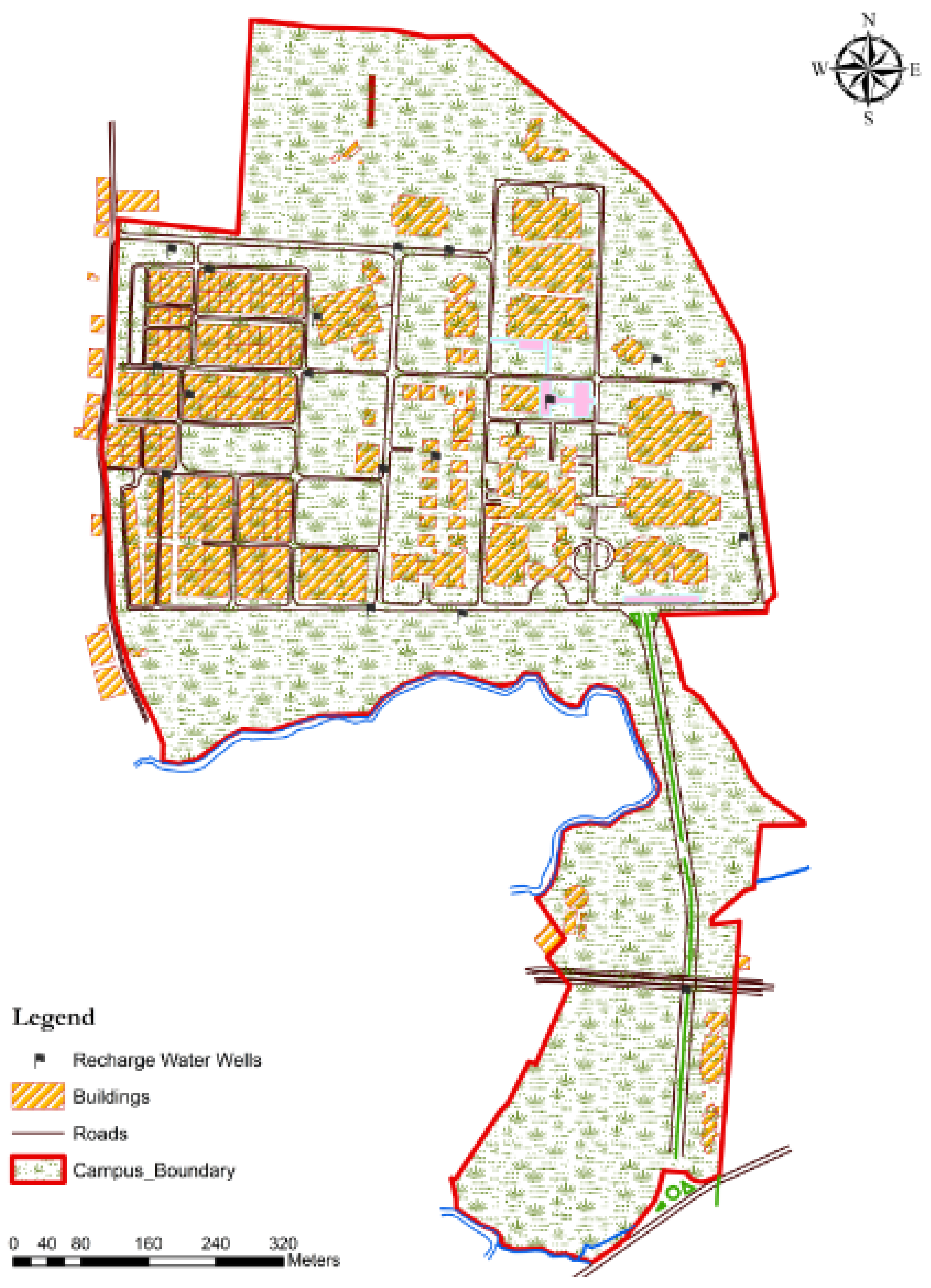
The groundwater is depleting every year due to land-use change and climatic variations. Hence there is a need to design a rainfall harvesting system in order to raise groundwater by installing an artificial groundwater recharge system. There are twenty depression points in the study area where water accumulates during rainfall. These points are observed by field visits after every rainfall event during the past few months as shown in Figure 4.
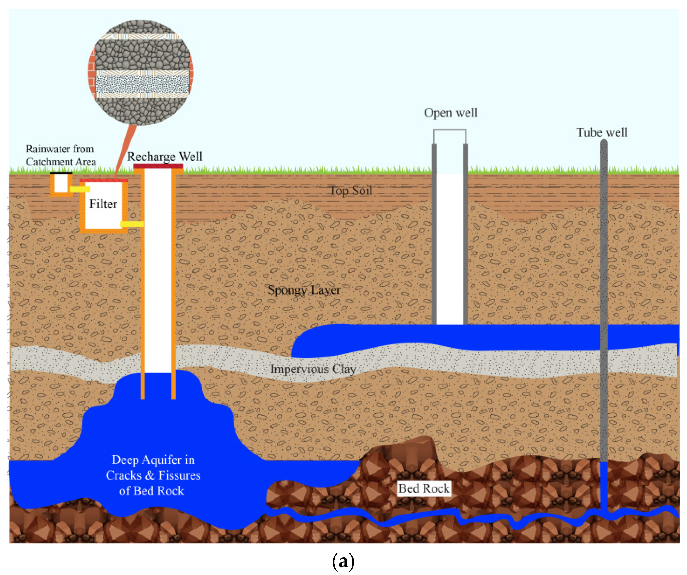
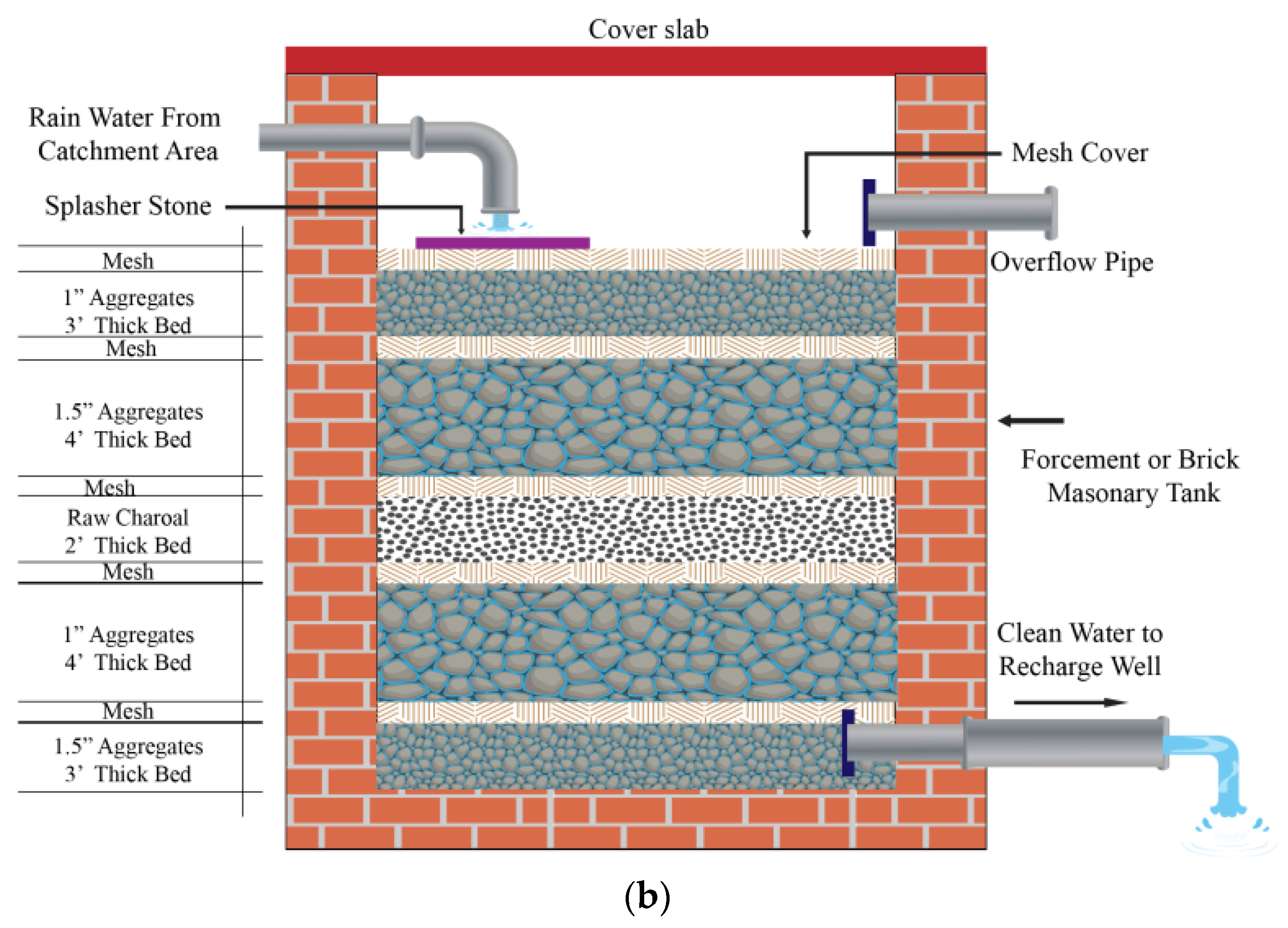
The groundwater recharge and rising of water table phenomena are shown in Figure 5a. The surface runoff is received in a filter to filtrate water before going to recharge well. The components of the filter are shown in Figure 5b. Recharge wells are proposed for groundwater recharge at these depression points for recharge water to the underground layers which tend to become the part of groundwater table and the level of the groundwater table will rise within few years. The design of recharge wells for water harvesting is based on the amount of water accumulating in the recharge well. The recharge borehole should be at a depth close to the water table. The water will percolate in deeper soil layers in a downward direction which tends to raise the existing groundwater table. The percolation rate depends upon the coefficient of permeability, different coefficients for soil type are shown in Table 1.
The residential area of the University is excluded for rooftop harvesting but included for groundwater recharge. The annual rainfall data of the study area is obtained from the Pakistan Metrological Department which consists of monthly data from 2004–2011 as shown in Figure 6.

2.2. Methodology

The proposed harvesting scheme is divided into two parts, i.e., water harvesting from the rooftop, which can be used for horticulture requirements, and runoff water accumulation in the recharge wells in different locations of the study area.

2.2.1. Water Harvesting from Rooftop

The harvestable water from rooftops can be collected in storage tanks. The amount of discharge that can be harvested is calculated by the following rational formula (Equation (1)):
Q = C·I·A
where “Q” is the runoff (cusecs), “I” is the average rainfall intensity (inch per unit time), “A” is the drainage area (ft2) calculated by Arc GIS, and “C” is the runoff coefficient (no units) depending on the catchment characteristics. This factor accounts for the fact that some of the rainfall cannot be collected due to the loss of water during evaporation and retention on the surface itself [37,38]. The value of “C” is taken as 0.75.

2.2.2. Water Harvesting from Rooftop

Elevation raster is pixel-based elevation data that can be classified to assess the flow path of rainwater. This raster is generated by using contour lines that represent the geometry of physical features on the topographical maps. For the study area of UET Taxila, a handheld Garmin Etrex 10 in combination with a GeoMax total station was utilized. Initial coordinates of the start-up station were assessed using a handheld GPS. After setting it up with certain parameters in its configuration, i.e., indexing vertical and horizontal reference directions, heights of the instrument (HI), and target prism (HR), not only the horizontal but also the vertical angles, sloping distances, and three-dimensional coordinates were also computed. Working with this machine, prism points were recorded using the complete survey information and were stored in its electronic notebook. Later on, the surveyed data were retrieved from a computer for the purpose of raster elevation rendering. To achieve higher accuracy of the raster data model for elevations, a total of 1892 prism points were taken in the study area. The 3D elevation map of the university is shown in Figure 7.
Contours were generated with the help of ArcGIS using the IDW analyst tool at an interval of three feet. The flow directions were found, and layered symbology of raster pixels was assigned. A total of eight classes of elevation raster were made to find out the flow path of rainfall. The contours and flow direction map is shown in Figure 8. This direction map highlighting the direction of flow indicates water movement from cell to cell. In most of northern zone, water flow direction was found in northwest whereas on southern region waterflow was predominantly in southeastern direction. This flow may be associated with the fact that spatially connected cells contribute to the flow direction based on slope of each cell resulting from the field survey. As a result, most of the pixels residing on top, will yield the flow direction towards low lying areas. Likewise, if the direction of steepest pixel is towards the left, the water flow will also receive the direction code (indicated with corresponding arrow) towards left. Also, resulting pixels with high flow directions kept on accumulating the water resulted in concentrated flow points as shown in Figure 8. On the other hand, all the pixels where flow direction do not indicate any accumulation were indication of the ridges where the potential recharge was zero.
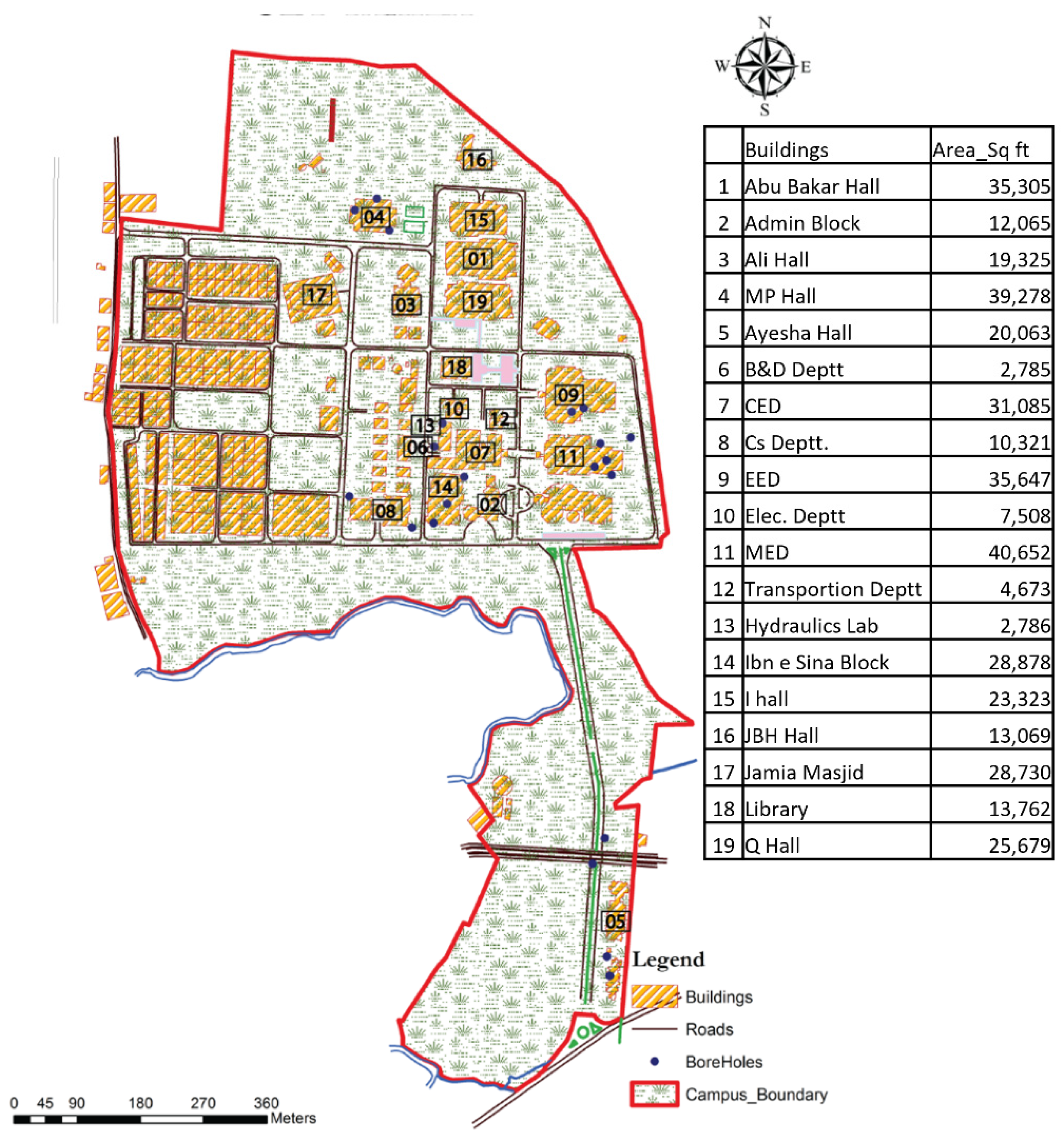
Geo-referencing and map digitization was carried out to overlay the buildings’ orientation roof areas. The elevation raster was superimposed on the digitized map and a 3D TIN surface was generated. In addition to building polygons and road polylines, boreholes were also pin-pointed based on their geographical location. 3D elevation raster was also counter-checked with the help of photographs taken during the rainfall at UET Taxila. Finally, 19 major locations of water accumulation points were reflected for rainwater accumulation. Rooftop areas and water accumulation points are highlighted in Figure 9 and Figure 10 respectively. Analysis showed that, if natural resources are to preserve, accumulation points should be considered. Knowing the resulting points prior to designing the potential recharge wells majority of the flow pathways would be reserved and the corresponding volume of water loss would be prevented.
As, shown in Figure 9, this study utilizing the data derived from field survey was not limited to the topographic analysis, but also roof tops’ areas for all the buildings were measured. After geographically locating the regions, potential roof tops were mapped for better accuracy. Not only, this approach was effective to visualize the areas graphically but also it helped discovering the area information of each unit of the settlement. Importantly, it also helped visualizing the neighboring structures near to those of the predicted points of water accumulation. Predominantly building structures covered a total of 394,935.3 ft2. Excluding other man-made features such as cafeterias and parking zones, these building units were almost covering a total of 6% of the gross area of the university. Moreover, it was observed that building patterns were mainly land-use dependent, following similar hierarchy for academic buildings whereas residential units were geospatially based on social interaction. Symbolically associating the settlements based on topographic pattern also help identifying the structures contributing to or altering the flow of water.
The soil types are investigated by boreholes data at different locations of the study area with the collaboration of Soil Mechanics Lab, UET Taxila. These location points are highlighted in Figure 10. The soil classification of each borehole is shown in Table 2.

3. Results and Discussion

Previously, rainfall harvesting systems were only adopted for flushing. However, the advancement in the research field has resulted in harvesting rainwater for irrigation and groundwater recharge [46]. Therefore, the current research results align with the previous research showing similar results for sustainability of rainfall water by utilizing rooftop water, and that this water that can be infiltrated as a subsurface flow [47,48].
The maintenance of rainfall harvesting tanks and wells should be properly managed; otherwise, the system’s performance may be reduced [49]. This system collects rainwater and stores its runoff, which comprises the collection, storage, treatment, and distribution of rainwater from roofs and impermeable surfaces [50]. Hence, rainwater utilization depends highly on the local water supply and demand conditions [51]. In some countries, rainwater is allowed for non-drinking purposes only, e.g., Australia, Germany, Japan, and the United States [52]. However, in France, rainfall-harvested water is not allowed for general purposes [53].
Previously, many researchers have calculated the percentage of water that can be saved within their study areas to check the efficiency of the proposed harvesting system. For example, in Jordan, 12 different cities have been studied for harvesting drinking water rainfall, and the system’s resulting efficiency is 0 to 20% [54]. Similarly, this resulted in a study of 22 cities in Egypt that showed that the amount of water that could be saved from the RHW system was 0 to 12% [55]. Finally, a study was conducted in Germany to investigate the effectiveness of the RWH system for household usage. The results indicated that 30 to 60% of water could be saved by applying the system [56].
Similarly, the RWH system for household use was also implemented in Spain, which resulted in a 16% potential saving of water within the study area [57]. In Brazil, the RWH system was studied at a large scale, and involved 195 cities, with the results finding that the potential that could be saved in big cities was 12% to 79% [58], and it was 22 to 64% in low-income houses [59]. In Brazil, a study was also conducted for multistorey buildings, and it was calculated that potable water efficiency saved 39% to 43% of water. However, the use of rainwater could generate 15 to 18% more water [60]. The potential of RWH systems for storing a percentage of floodwater volumes can also be quantified using flood modeling software, such as FLO-2D, and can be used for planning effective flood risk mitigation options, as demonstrated for an urban area in Southern Italy [61].
In the current study, the RWH system was studied at the University of Engineering and Technology (UET), Taxila, Punjab, Pakistan, to calculate the amount of water (in percentage) that could be harvested. The UI GreenMetric World University Ranking shows that the UET Taxila stands at 735 [62]. Therefore, a huge amount of water is required for horticultural purposes within the campus. Currently, the horticulture requirement of the university is fulfilled by extracting water from a tubewell specified only for irrigating plants and trees inside the campus. The survey from the horticultural department of the campus revealed that the total requirement for watering the green area of the campus is 125,125 ft3 per month, which exceeds the availability. The total rooftop area of 19 different buildings on the campus is 394,935.3 ft2, as calculated by Arc GIS. The water from the outlets of the rooftops could be collected in storage tanks. The total harvestable water from the rooftops was calculated using the rational formula (Equation (1)), where the value of “C” is taken at 0.75 and the average rainfall intensity (ft/year) is used. The total harvestable water from the rooftop is 74,050.34 ft3 per month, which is 59% of the total water used per month for irrigating plants and trees. Hence, we can provide 59% additional water for irrigation purposes by harvesting.
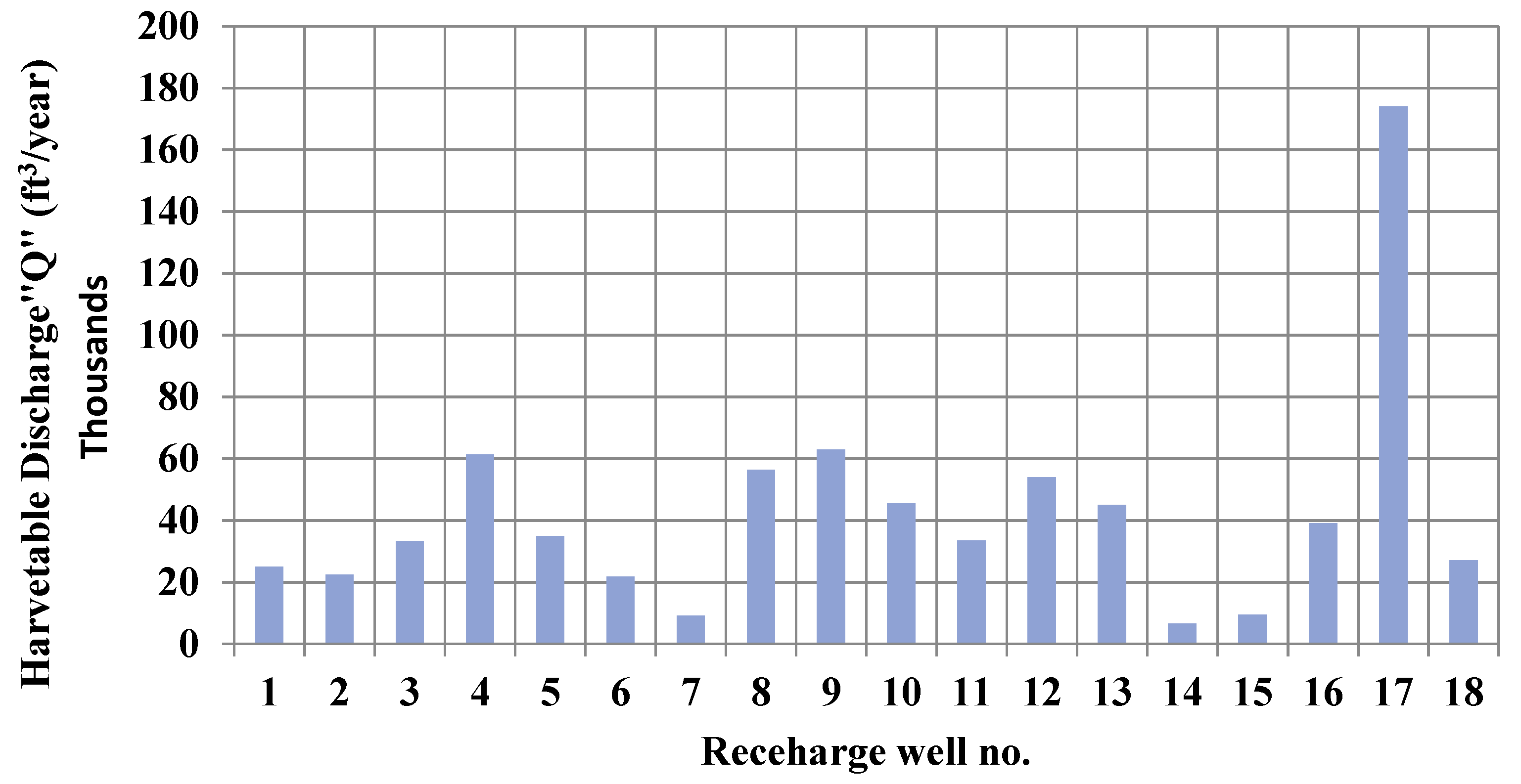
The discharge of water from catchments to the recharge wells’ location is calculated by the rational formula (Equation (1)), where the value of “C” is taken as 0.75 and the average rainfall intensity (ft/year) is used. All of the proposed recharge wells will contribute to harvesting water for groundwater recharge. The amount of water harvestable from each recharge well is shown in Figure 11. The total harvestable discharge for groundwater recharge is 761,400 ft3/year. Hence, applying the RWH on the campus will save the groundwater, and the deficiency in water availability can also be fulfilled.

4. Conclusions

At the end of this study, the following is concluded:
  • A significant amount of highly valued water is usually lost from rooftops and direct runoff after each rainfall event.
  • The water required to irrigate trees and plants on the campus is 125,125 ft3 per month, which exceeds the irrigation requirements. Water can be conserved by proper planning to harvest rainfall from rooftop areas and this water can be used for agriculture, domestic, or drinking purposes. In this study, it was calculated that we could save 74,050.34 ft3 of water per month by using a rooftop harvesting system on the campus, which can be used as an additional source of water for irrigation purposes. In this way, 59% of the current water used for this purpose could be harvested.
  • Water can also be conserved by installing recharge wells at proper locations in the area, and after recharging water to the deeper layers, the groundwater table will rise. In this study, it is calculated that by installing recharge wells at suitable locations, we can use 761,400 ft3/year of water for groundwater development.
This research can be extended through a detailed study of the groundwater response to recharge water if the proper amount of soil classification data up to the water table are available.

Author Contributions

Conceptualization, A.A. and A.R.G.; data curation, A.A. and R.F.; formal analysis, A.A. and G.A.P.; investigation, A.A., M.V. and S.J.; methodology, A.A., A.R.G., M.A., G.A.P. and S.J.; project administration, M.V. and A.R.G.; resources, A.A., G.A.P. and R.F.; software, A.A., M.A. and R.F.; supervision, M.V. and A.R.G.; writing—original draft, A.A. and M.A.; writing—review and editing, A.A., M.V., A.R.G., G.A.P., R.F. and S.J. All authors have read and agreed to the published version of the manuscript.

Funding

This study was funded by HEC Pakistan under International research support initiative program”. No: IRSIP 44 Engg. 07, 1-8/HEC/HRD/2019/10122.

Data Availability Statement

All data are presented in the manuscript.

Conflicts of Interest

The authors declare no conflict of interest.

References

  1. Zhu, Q.; Gould, J. Rainwater harvesting irrigation—A strategic measure for integrated rural development in the dry mountainous areas of Gansu province, China. In Rainwater-Smart Agriculture in Arid and Semi-Arid Areas; Springer: Cham, Switzerland, 2018; pp. 235–257. [Google Scholar] [CrossRef]
  2. Helmreich, B.; Harald, H. Opportunities in rainwater harvesting. Desalination 2009, 248, 118–124. [Google Scholar] [CrossRef]
  3. Latif, S.; Alim, M.A.; Rahman, A. Disinfection methods for domestic rainwater harvesting systems: A scoping review. J. Water Process Eng. 2022, 46, 102542. [Google Scholar] [CrossRef]
  4. Yang, Y.; Javanroodi, K.; Nik, V.M. Climate Change and Renewable Energy Generation in Europe—Long-Term Impact Assessment on Solar and Wind Energy Using High-Resolution Future Climate Data and Considering Climate Uncertainties. Energies 2022, 15, 302. [Google Scholar] [CrossRef]
  5. Morris, B.L.; Lawrence, A.R.L.; Chilton, P.J.C.; Adams, B.; Calow, R.C.; Klinck, B.A. Groundwater and its Susceptibility to Degradation: A Global Assessment of the Problem and Options for Management; Early Warning and Assessment Report Series; RS. 03-3; United Nations Environment Programme: Nairobi, Kenya, 2003. [Google Scholar]
  6. Nawaz, A.; Shah SA, R.; Su, X.; Dar, A.A.; Qin, Z.; Albasher, G. Analytical strategies to sense water stress level: An analysis of ground water fluctuations sensing SDGs under pandemic scenario. Chemosphere 2022, 291, 132924. [Google Scholar] [CrossRef] [PubMed]
  7. Wada, Y.; Bierkens, M.F. Sustainability of global water use: Past reconstruction and future projections. Environ. Res. Lett. 2014, 9, 104003. [Google Scholar] [CrossRef]
  8. Laghari, A.; Vanham, D.; Rauch, W. The Indus basin in the framework of current and future water resources management. Hydrol. Earth Syst. Sci. 2012, 16, 1063–1083. [Google Scholar] [CrossRef]
  9. Island, P.E. Application of numerical modeling to groundwater assessment and management in Prince Edward Island. In Proceedings of the 2004 57th Canadian Geotechnical Conference, Québec, QC, Canada, 25–27 October 2004. [Google Scholar]
  10. Qureshi, A.S. Groundwater governance in Pakistan: From colossal development to neglected management. Water 2020, 12, 3017. [Google Scholar] [CrossRef]
  11. Qureshi, A.S.; Gill, M.A.; Sarwar, A. Sustainable groundwater management in Pakistan: Challenges and opportunities. Irrigation and Drainage. J. Int. Comm. Irrig. Drain. 2010, 59, 107–116. [Google Scholar] [CrossRef]
  12. Khan, S.; Rana, T.; Gabriel, H.; Ullah, M.K. Hydrogeologic assessment of escalating groundwater exploitation in the Indus Basin, Pakistan. Hydrogeol. J. 2008, 16, 1635–1654. [Google Scholar] [CrossRef]
  13. Wada, Y.; Van Beek, L.P.; Van Kempen, C.M.; Reckman, J.W.; Vasak, S.; Bierkens, M.F. Global depletion of groundwater resources. J. Water Resour. Prot. 2010, 1, 37. [Google Scholar] [CrossRef]
  14. Walsh, C.J.; Fletcher, T.D.; Burns, M.J. Urban stormwater runoff: A new class of environmental flow problem. PLoS ONE 2012, 7, e45814. [Google Scholar] [CrossRef]
  15. Mikkelsen, P.; Adeler, O.; Albrechtsen, H.-J.; Henze, M. Collected rainfall as a water source in Danish households-what is the potential and what are the costs? Water Sci. Technol. 2016, 39, 49–56. [Google Scholar] [CrossRef]
  16. Melville-Shreeve, P.; Ward, S.; Butler, D. Rainwater harvesting typologies for UK houses: A multi-criteria analysis of system configurations. Water 2016, 8, 129. [Google Scholar] [CrossRef]
  17. Mugume, S.N.; Melville-Shreeve, P.; Gomez, D.; Butler, D. Multifunctional urban flood resilience enhancement strategies. In Proceedings of the Institution of Civil Engineers-Water Management; Thomas Telford Ltd.: London, UK, 2016; Volume 170, pp. 115–127. [Google Scholar]
  18. Teston, A.; Piccinini Scolaro, T.; Kuntz Maykot, J.; Ghisi, E. Comprehensive Environmental Assessment of Rainwater Harvesting Systems: A Literature Review. Water 2022, 14, 2716. [Google Scholar] [CrossRef]
  19. Burns, M.J.; Schubert, J.E.; Fletcher, T.D.; Sanders, B.F. Testing the impact of source stormwater management on urban flooding through a coupling of network and overland flow models. Wiley Interdiscip. Rev. Water 2015, 2, 291–300. [Google Scholar] [CrossRef]
  20. Batalini de Macedo, M.; Nobrega Gomes Junior, M.; Pereira de Oliveira, T.R.; HGiacomoni, M.; Imani, M.; Zhang, K.; Mendiondo, E.M. Low Impact Development practices in the context of United Nations Sustainable Development Goals: A new concept, lessons learned and challenges. Crit. Rev. Environ. Sci. Technol. 2022, 52, 2538–2581. [Google Scholar] [CrossRef]
  21. DeBusk, K.; Hunt, W.; Wright, J. Characterizing rainwater harvesting performance and demonstrating stormwater management benefits in the humid southeast USA. JAWRA J. Am. Water Resour. Assoc. 2013, 49, 1398–1411. [Google Scholar] [CrossRef]
  22. Zhang, Y.; Chen, D.; Chen, L.; Ashbolt, S. Potential for rainwater use in high-rise buildings in Australian cities. J. Environ. Manag. 2009, 91, 222–226. [Google Scholar] [CrossRef]
  23. Barron, J. Background: The water component of ecosystem services and in human well-being development targets. In Rainwater Harvesting: A Lifeline for Human Well-Being; UNEP/Earthprint: Nairobi, Kenya, 2009. [Google Scholar]
  24. Dile, Y.T.; Karlberg, L.; Temesgen, M.; Rockström, J. The role of water harvesting to achieve sustainable agricultural intensification and resilience against water related shocks in sub-Saharan Africa. Agric. Ecosyst. Environ. 2013, 181, 69–79. [Google Scholar] [CrossRef]
  25. Rockström, J.; Falkenmark, M. Agriculture: Increase water harvesting in Africa. Nature 2015, 519, 283–285. [Google Scholar] [CrossRef]
  26. Fernandes, L.F.S.; Terêncio, D.P.; Pacheco, F.A. Rainwater harvesting systems for low demanding applications. Sci. Total Environ. 2015, 529, 91–100. [Google Scholar] [CrossRef] [PubMed]
  27. Vohland, K.; Barry, B. A review of in situ rainwater harvesting (RWH) practices modifying landscape functions in African drylands. Agric. Ecosyst. Environ. 2009, 131, 119–127. [Google Scholar] [CrossRef]
  28. Xu, W.D.; Fletcher, T.D.; Duncan, H.P.; Bergmann, D.J.; Breman, J.; Burns, M.J. Improving the Multi-Objective Performance of Rainwater Harvesting Systems Using Real-Time Control Technology. Water 2018, 10, 147. [Google Scholar] [CrossRef]
  29. Ghayoumian, J.; Ghermezcheshme, B.; Feiznia, S.; Noroozi, A.A. Integrating GIS and DSS for identification of suitable areas for artificial recharge, case study Meimeh Basin, Isfahan, Iran. Environ. Geol. 2005, 47, 493–500. [Google Scholar] [CrossRef]
  30. Al Saud, M. Mapping potential areas for groundwater storage in Wadi Aurnah Basin, western Arabian Peninsula, using remote sensing and geographic information system techniques. Hydrogeol. J. 2010, 18, 1481–1495. [Google Scholar] [CrossRef]
  31. Chenini, I.; Mammou, A.B.; El May, M. Groundwater recharge zone mapping using GIS-based multi-criteria analysis: A case study in Central Tunisia (Maknassy Basin). Water Resour. Manag. 2010, 24, 921–939. [Google Scholar] [CrossRef]
  32. Machiwal, D.; Jha, M.K.; Mal, B.C. Assessment of groundwater potential in a semi-arid region of India using remote sensing, GIS and MCDM techniques. Water Resour. Manag. 2011, 25, 1359–1386. [Google Scholar] [CrossRef]
  33. Malekmohammadi, B.; Mehrian, M.R.; Jafari, H.R. Site selection for managed aquifer recharge using fuzzy rules: Integrating geographical information system (GIS) tools and multi-criteria decision making. Hydrogeol. J. 2012, 20, 1393–1405. [Google Scholar] [CrossRef]
  34. Hammouri, N.; Al-Amoush, H.; Al-Raggad, M.; Harahsheh, S. Groundwater recharge zones mapping using GIS: A case study in Southern part of Jordan Valley, Jordan. Arab. J. Geosci. 2014, 7, 2815–2829. [Google Scholar] [CrossRef]
  35. Fewkes, A. A review of rainwater harvesting in the UK. Struct. Surv. 2012, 30, 174–194. [Google Scholar] [CrossRef]
  36. Kahinda, J.M.; Taigbenu, A.E.; Boroto, J.R. Domestic rainwater harvesting to improve water supply in rural South Africa. Phys. Chem. Earth Parts A/B/C 2007, 32, 1050–1057. [Google Scholar] [CrossRef]
  37. Lee, K.E.; Mokhtar, M.; Hanafiah, M.M.; Halim, A.A.; Badusah, J. Rainwater harvesting as an alternative water resource in Malaysia: Potential, policies and development. J. Clean. Prod. 2016, 126, 218–222. [Google Scholar] [CrossRef]
  38. Kakoulas, D.A.; Golfinopoulos, S.K.; Koumparou, D.; Alexakis, D.E. The Effectiveness of Rainwater Harvesting Infrastructure in a Mediterranean Island. Water 2022, 14, 716. [Google Scholar] [CrossRef]
  39. Lopez Mendez, B.; Huhn, L. Literature Review on Managed Aquifer Recharge in the Context of Water and Soil Restoration Methods; Abwasserwirtschaft und Gewässerschutz B-2: Hamburg, Germany. [CrossRef]
  40. Rahman, A.; Keane, J.; Imteaz, M.A. Rainwater harvesting in Greater Sydney: Water savings, reliability and economic benefits. Resour. Conserv. Recycl. 2012, 61, 16–21. [Google Scholar] [CrossRef]
  41. Sharma, B.; Amarasinghe, U.; Xueliang, C.; de Condappa, D.; Shah, T.; Mukherji, A.; Bharati, L.; Ambili, G.; Qureshi, A.; Pant, D.; et al. The Indus and the Ganges: River basins under extreme pressure. In Water, Food and Poverty in River Basins; Routledge: Oxfordshire, UK, 2013; pp. 40–68. [Google Scholar] [CrossRef]
  42. Archer, D.R.; Forsythe, N.; Fowler, H.J.; Shah, S.M. Sustainability of water resources management in the Indus Basin under changing climatic and socio economic conditions. Hydrol. Earth Syst. Sci. 2010, 14, 1669–1680. [Google Scholar] [CrossRef]
  43. Kazmi, S.I.; Ertsen, M.W.; Asi, M.R. The impact of conjunctive use of canal and tube well water in Lagar irrigated area, Pakistan. Phys. Chem. Earth Parts A/B/C 2012, 47, 86–98. [Google Scholar] [CrossRef]
  44. Watto, M.A.; Mugera, A.W. Groundwater depletion in the Indus Plains of Pakistan: Imperatives, repercussions and management issues. Int. J. River Basin Manag. 2016, 14, 447–458. [Google Scholar] [CrossRef]
  45. Humphreys, E.; Kukal, S.S.; Christen, E.W.; Hira, G.S.; Sharma, R.K. Halting the groundwater decline in north-west India—which crop technologies will be winners? Adv. Agron. 2010, 109, 155–217. [Google Scholar] [CrossRef]
  46. DeBusk, K.M.; Hunt, W.F.; Wright, J.D. Characterization of rainwater harvesting utilization in humid regions of the United States. J. Am. Water Resour. Assoc. 2013, 49, 1398–1411. [Google Scholar] [CrossRef]
  47. Collins, R. Effectiveness of domestic rainwater tanks. Water J. Aust. Water Assoc. 2008, 35, 116–120. [Google Scholar]
  48. Burns, M.J.; Fletcher, T.D.; Duncan, H.P.; Hatt, B.E.; Ladson, A.R.; Walsh, C.J. The performance of rainwater tanks for stormwater retention and water supply at the household scale: An empirical study. Hydrol. Processes 2015, 29, 152–160. [Google Scholar] [CrossRef]
  49. Heyworth, J.S.; Glonek, G.; Maynard, E.J.; Baghurst, P.A.; Finlay-Jones, J. Consumption of untreated tank rainwater and gastroenteritis among young children in South Australia. Int. J. Epidemiol. 2006, 35, 1051–1058. [Google Scholar] [CrossRef]
  50. Campisano, A.; Modica, C. Rainwater harvesting as source control option to reduce roof runoff peaks to downstream drainage systems. J. Hydroinform. 2015, 18, 23–32. [Google Scholar] [CrossRef]
  51. Haque, M.M.; Rahman, A.; Samali, B. Evaluation of climate change impacts on rainwater harvesting. J. Clean. Prod. 2016, 137, 60–69. [Google Scholar] [CrossRef]
  52. Yannopoulos, S.; Giannopoulou, I.; Kaiafa-Saropoulou, M. Investigation of the current situation and prospects for the development of rainwater harvesting as a tool to confront water scarcity worldwide. Water 2019, 11, 2168. [Google Scholar] [CrossRef]
  53. Vialle, C.; Busset, G.; Tanfin, L.; Montrejaud-Vignoles, M.; Huau, M.C.; Sablayrolles, C. Environmental analysis of a domestic rainwater harvesting system: A case study in France. Resour. Conserv. Recycl. 2015, 102, 178–184. [Google Scholar] [CrossRef]
  54. Abdulla, F.A.; Al-Shareef, A.W. Roof rainwater harvesting systems for household water supply in Jordan. Desalination 2009, 243, 195–207. [Google Scholar] [CrossRef]
  55. Gado, T.A.; El-Agha, D.E. Feasibility of rainwater harvesting for sustainable water management in urban areas of Egypt. Environ. Sci. Pollut. Res. 2020, 27, 32304–32317. [Google Scholar] [CrossRef]
  56. Herrmann, T.; Schmida, U. Rainwater utilisation in Germany: Efficiency, dimensioning, hydraulic and environmental aspects. Urban Water 2000, 1, 307–316. [Google Scholar] [CrossRef]
  57. Domènech, L.; Saurí, D. A comparative appraisal of the use of rainwater harvesting in single and multi-family buildings of the Metropolitan Area of Barcelona (Spain): Social experience, drinking water savings and economic costs. J. Clean. Prod. 2011, 19, 598–608. [Google Scholar] [CrossRef]
  58. Ghisi, E.; Bressan, D.L.; Martini, M. Rainwater tank capacity and potential for potable water savings by using rainwater in the residential sector of southeastern Brazil. Build. Environ. 2007, 42, 1654–1666. [Google Scholar] [CrossRef]
  59. Vieira, A.S.; Ghisi, E. Water-energy nexus in low-income houses in Brazil: The influence of integrated on-site water and sewage management strategies on the energy consumption of water and sewerage services. J. Clean. Prod. 2016, 133, 145–162. [Google Scholar] [CrossRef]
  60. Ghisi, E.; Ferreira, D.F. Potential for potable water savings by using rainwater and greywater in a multi-storey residential building in southern Brazil. Build. Environ. 2007, 42, 2512–2522. [Google Scholar] [CrossRef]
  61. Freni, G.; Liuzzo, L. Effectiveness of Rainwater Harvesting Systems for Flood Reduction in Residential Urban Areas. Water 2019, 11, 1389. [Google Scholar] [CrossRef]
  62. Available online: www.greenmetric.ui.ac.id (accessed on 3 January 2021).
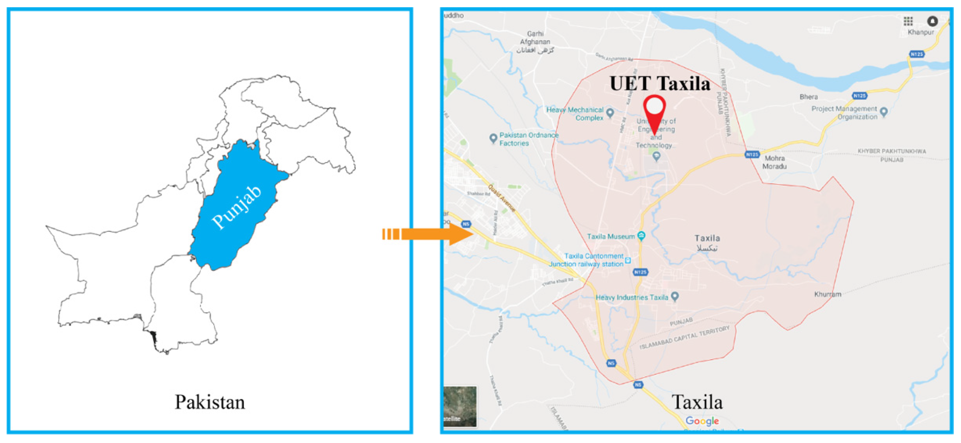
Figure 1. Map of the study area [source: GoogleMaps©].
Civileng 03 00051 g001
Figure 2. Maximum rainfall per day per year (in/year).
Civileng 03 00051 g002
Figure 3. Schematic diagram of a rooftop harvesting system.
Civileng 03 00051 g003
Figure 4. Water accumulation points observed during and after the rainfall events.
Civileng 03 00051 g004
Figure 5. (a) Groundwater level rises by recharge well, and (b) Schematic diagram of filter.
Civileng 03 00051 g005aCivileng 03 00051 g005b
Figure 6. Annual rainfall (2004–2011) in/year.
Civileng 03 00051 g006
Figure 7. The 3D elevation map of UET Taxila.
Civileng 03 00051 g007
Figure 8. Contours and surface runoff flow direction map.
Civileng 03 00051 g008
Figure 9. Demonstration of the roof tops considered and the respective area estimation for each building.
Civileng 03 00051 g009
Figure 10. Water accumulation points where recharge wells are proposed.
Civileng 03 00051 g010
Figure 11. Harvestable water from each recharge well “Q” (ft3/year).
Civileng 03 00051 g011
Table 1. Typical ranges of permeability coefficients for different soil types [45].
Sr. NoSoil TypeCoefficient of Permeability (mm/s)
1Clean gravel10+1–10+2
2Coarse and medium sands10−2–10+1
3Fine sand, loose silt10−4–10−2
4Dense silt, clayey silts10−5–10−4
5Silty clay10−8–10−5
Table 2. Soil classification of boreholes.
Depth
Upto
Bore Hole
No.
Location near byType of Soil
30′1Telecom DepartmentSandy Silt
30′2Telecom DepartmentSandy Silt
30′3Combined Academic BlockClay
30′4Combined Academic BlockClay
30′5Combined Academic BlockClay
15′6Girls HostelSilt
15′7Girls HostelSilt
30′8Overhead BridgeSilt
30′9Overhead BridgeSilt
30′10Industrial DepartmentSilt
30′11Industrial DepartmentSilt
30′12Industrial DepartmentSilt
30′13Industrial DepartmentSilt
30′14Industrial DepartmentSilt
20′15Electrical Department.Clay
20′16Electrical DepartmentClay
60′17MP HallSillty Clay
30′18MP HallSilty Clay
50′19MP HallSilty Clay
20′20Hydraulics LabSilt
20′21Hydraulics LabSilt
Publisher’s Note: MDPI stays neutral with regard to jurisdictional claims in published maps and institutional affiliations.