Proceeding Paper

Deep Learning for Automated Water Segmentation through CCTV Images in Agricultural Reservoirs †

Department of Civil and Environmental Engineering, Hannam University, Daejeon 34430, Republic of Korea
*
Author to whom correspondence should be addressed.
Presented at the 3rd International Joint Conference on Water Distribution Systems Analysis & Computing and Control for the Water Industry (WDSA/CCWI 2024), Ferrara, Italy, 1–4 July 2024.
Eng. Proc. 2024, 69(1), 140; https://doi.org/10.3390/engproc2024069140
Published: 10 September 2024

Abstract

:
Estimating water levels in agricultural reservoirs is crucial for sustainable water management. However, accurate estimation faces limitations due to data scarcity and the labor-intensive nature of image processing. To address this, we propose an automatic image segmentation model for agricultural reservoirs based on transfer learning. We evaluated its accuracy using CCTV images and achieved a high accuracy rate of 95–99%. This automated approach can assure improvements in water level estimation in unmeasured agricultural reservoirs by providing advanced image processing results.

1. Introduction

Agricultural reservoirs play a critical role in ensuring a reliable water supply for agricultural needs. Effective water management for irrigation systems relies on accurately predicting reservoir water availability, which typically involves monitoring water levels. However, unlike other types of reservoirs, agricultural reservoirs face various challenges in regular water level monitoring due to budget constraints and their extensive spatial distribution [1]. These limitations underscore the need for alternative approaches to estimate water levels in agricultural reservoirs.
One such approach is by utilizing deep learning models. Several studies have applied such approaches in the agricultural water supply field. For example, Joo et al. [2] utilized a ResNet-50 model to estimate reservoir water levels through image preprocessing and classification. Similarly, Kim et al. [3] employed a ResNet-50-based U-Net model for estimating irrigation water levels.
However, despite the progress made in utilizing deep learning models for water level estimation, notable limitations and challenges persist. Achieving high accuracy in image segmentation is crucial for ensuring the reliability and convenience of water level estimation, especially in agricultural settings where variations in terrain and environmental conditions can impact the efficacy of traditional monitoring methods. Additionally, image segmentation typically requires human effort and is considered a tedious task that is subject to variation between individuals.
Therefore, this study proposes a novel automatic image segmentation approach using deep learning models to enhance both accuracy and convenience. We utilized CCTV images to isolate water and background areas and applied this approach to four different agricultural reservoirs.

2. Methods

2.1. Image Segmentation Using Transfer Learning

Image segmentation is a critical process for identifying objects pixel by pixel, assigning classes, and distinguishing areas by color for recognition. Representative deep learning models for image segmentation include FCN (Fully Convolutional Network), U-Net, and DeepLab v3. In this study, we adopted Liang et al.’s image segmentation module [4], utilizing transfer learning to retrain a pre-existing model’s segmentation module on similar data. Transfer learning is a technique that addresses insufficient image data by leveraging pre-trained models and adapting them to new datasets. The process is illustrated in Figure 1.
Liang et al.’s model was originally developed for flood depth prediction. It consists of modules for segmenting water areas and estimating flood depth based on the segmented areas. A notable feature of this model is the use of EfficientNet-B4 as the encoder part of U-Net. This choice enhances the spatial and temporal consistency of image data, resulting in a more accurate and stable image segmentation module compared to existing models [4]. Moreover, while other image segmentation models face challenges due to limited water image datasets for training, the dataset used in this model has been expanded and enriched by incorporating images of swimming pools, lakes, rivers, and floods.

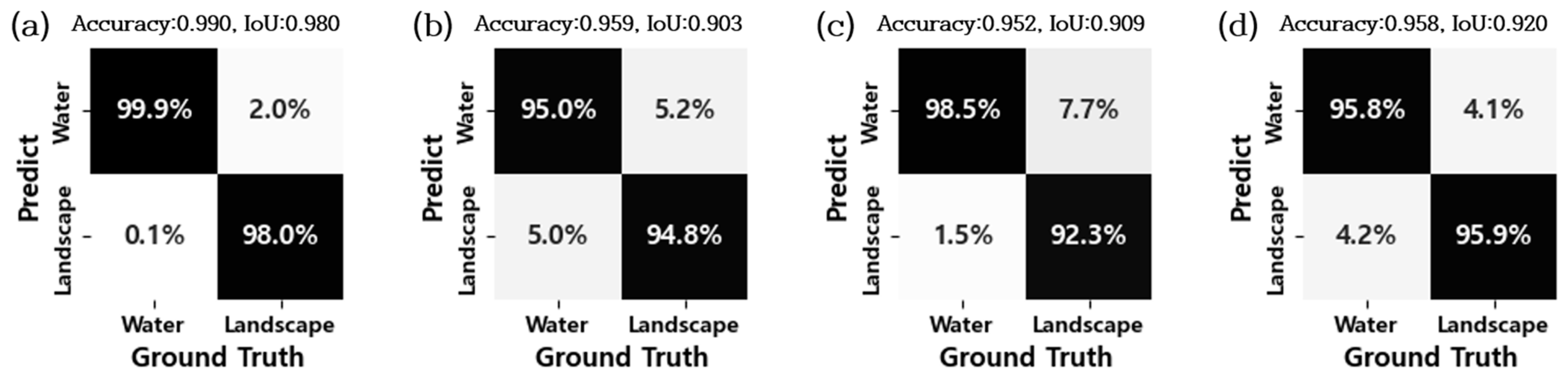
2.2. Performance Metrics

The performance of the image segmentation model was evaluated using a confusion matrix, a common statistical method for quantitatively representing the comparison between predicted and actual observations. Additionally, accuracy and IoU (Intersection over Union) [5] were computed as additional performance metrics, as demonstrated in Equations (1) and (2). It is worth noting that TP represents true positives, TN represents true negatives, FN represents false negatives, and FP represents false positives.
Accuracy = T P + T N T P + F N + F P + T N
IoU = T P T P + F N + F P

3. Experimental Setup

3.1. Study Sites and Data

The proposed model was applied to four agricultural reservoirs (Figure 2a–d). Image data for all reservoirs were obtained through the Korea Rural Community Corporation Integrated System. Data for M-reservoir and G-reservoir were collected from 21 June 2020, 00:00, to 18 July 2022, 23:00, at one-hour intervals, while data for C-reservoir and Y-reservoir were collected from 1 January 2023, 00:00, to 1 September 2023, 10:00, also at one-hour intervals. Prior to use, all collected image data underwent initial filtering to ensure suitability for the image segmentation model.

3.2. Model Implementations

The image segmentation model utilized the parameters specified for Liang et al.’s model [4] without fine-tuning the hyperparameters. The resolution of all training images was set to 416 × 416, with a batch size of 4. The initial learning rate was set to 10−4, which decreased to 1 × 10⁻⁵ during training. For image segmentation evaluation, the IoU metric was employed, and training was conducted for 150 epochs [4]. During transfer learning, image data from four reservoirs were utilized, totaling 7320 images for agricultural reservoir image segmentation model evaluation. The resolution of the images was set to 1920 × 1080 pixels.

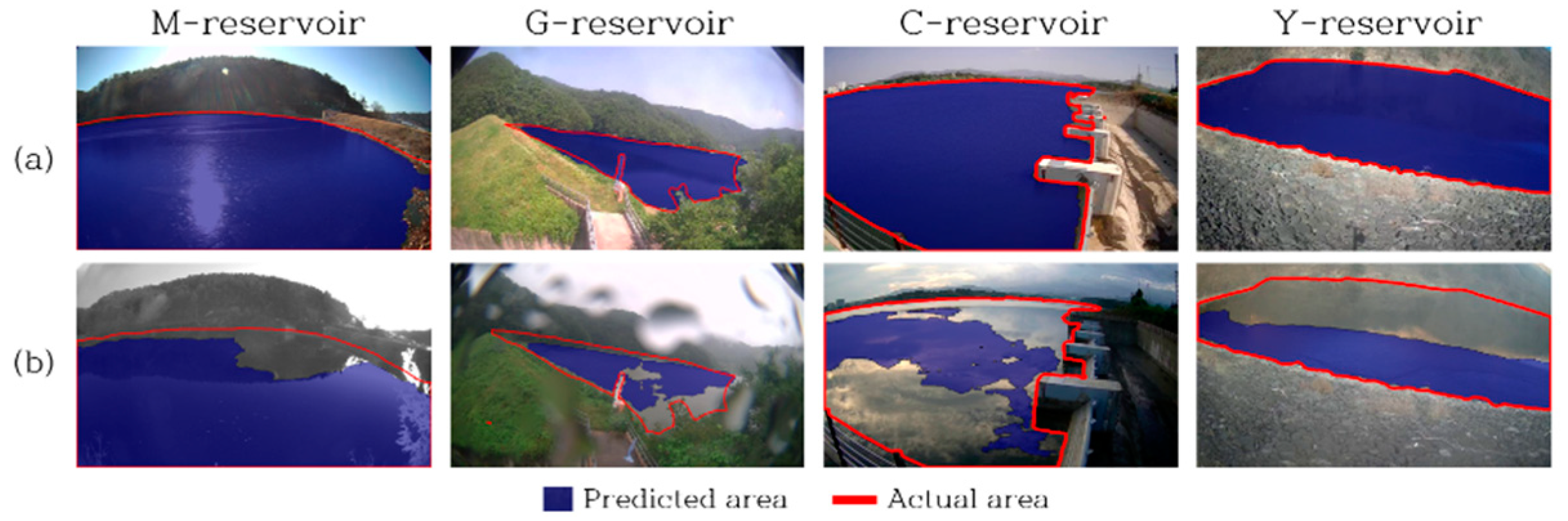
4. Results and Discussion

The results (Figure 3a–d) demonstrate that the proposed model achieves accuracy ranging from 95% to 99% across all agricultural reservoirs, indicating effective segmentation of water and background in the image data. Regarding evaluation metrics, most accuracies ranged from 0.92 to 0.99.
Figure 4 illustrates the water segmentation images of the estimated results obtained from the proposed model. Water areas segmented by the model are highlighted as a blue overlay, while the actual water boundary is represented in red. The M-reservoir exhibited the highest accuracy, attributed to the relatively low complexity of the image data. Conversely, in all other reservoirs, most predictions were accurate during daylight hours with high resolution and good weather conditions, but some inaccuracies occurred, as depicted in Figure 4b. The challenges in segmentation stemmed from various factors, including different colors of the water surface due to shadows (observed in M-reservoir and Y-reservoir), the obstruction of CCTV due to severe weather conditions (seen in G-reservoir), and excessive light reflection on the water surface (C-reservoir) due to stronger sunlight compared to other days. Moreover, challenges arose from low resolution during night-time. To enhance performance and prevent potential misclassification in water level estimation, increasing the diversity of image data samples is crucial.

5. Conclusions

This study introduced a novel method for estimating water levels using CCTV image data from agricultural reservoirs. By leveraging transfer learning from Liang et al. [4], specialized for water image segmentation, this study explored the applicability of deep semantic neural networks. Evaluation with CCTV image data from four agricultural reservoirs showed segmentation accuracy ranging from 95% to 99%. Accurate predictions were mainly observed in straightforward conditions or during daylight with high resolution, while inaccuracies were often due to obstacles, intense sunlight causing reflections, adverse weather, or low-resolution night-time images. Enhancements are expected through strategies like long-term data collection and diversified collection under various conditions. This research demonstrates the potential and advancement of the water level estimation process by accurately and efficiently estimating the water levels of agricultural reservoirs through image segmentation.

Author Contributions

Conceptualization, S.L. (Suhyun Lim); methodology, S.L. (Suhyun Lim), S.H.K. and S.L. (Seungyub Lee); software, S.H.K. and S.L. (Seungyub Lee); validation, S.L. (Suhyun Lim), S.H.K. and G.S.; investigation, S.L. (Suhyun Lim); resources, S.L. (Seungyub Lee); data curation, S.H.K.; writing—original draft preparation, review and editing, S.L. (Suhyun Lim), S.H.K., G.S. and S.L. (Seungyub Lee). All authors have read and agreed to the published version of the manuscript.

Funding

This work was supported by Korea Environmental Industry & Technology Institute (KEITI) through technology development project to optimize planning, operation, and maintenance of urban flood control facilities, funded by Korea Ministry of Environment (MOE) (RS-2024-00398012), and by the National Research Foundation of Korea (NRF) grant funded by the government of the Republic of Korea (No. NRF-2021R1C1C2004896).

Institutional Review Board Statement

Not applicable.

Informed Consent Statement

Not applicable.

Data Availability Statement

All data, models, and codes supporting the findings of this study are available from the corresponding author upon reasonable request.

Conflicts of Interest

The authors declare no conflicts of interest.

References

  1. Dhara, S.; Dang, T.; Parial, K.; Lu, X.X. Accounting for uncertainty and reconstruction of flooding patterns based on multi-satellite imagery and support vector machine technique: A case study of Can Tho City, Vietnam. Water 2020, 12, 1543. [Google Scholar] [CrossRef]
  2. Joo, D.H.; Lee, S.H.; Choi, G.H.; Yoo, S.H.; Na, R.; Kim, H.Y.; Oh, C.J.; Yoon, K.S. Development of Methodology for Measuring Water Level in Agricultural Water Reservoir through Deep Learning anlaysis of CCTV Images. J. Korean Soc. Agric. Eng. 2023, 65, 15–26. [Google Scholar]
  3. Kim, K.H.; Kim, M.G.; Yoon, P.R.; Bang, J.H.; Myoung, W.H.; Choi, J.Y.; Choi, G.H. Application of CCTV image and semantic segmentation model for water level estimation of irrigation channel. J. Korean Soc. Agric. Eng. 2022, 64, 63–73. [Google Scholar]
  4. Liang, Y.; Li, X.; Tsai, B.; Chen, Q.; Jafari, N. V-FloodNet: A video segmentation system for urban flood detection and quantification. Environ. Model. Softw. 2023, 160, 105586. [Google Scholar] [CrossRef]
  5. Maxwell, A.E.; Warner, T.A.; Guillén, L.A. Accuracy assessment in convolutional neural network-based deep learning remote sensing studies—Part 1: Literature review. Remote Sens. 2021, 13, 2450. [Google Scholar] [CrossRef]
Figure 1. Image segmentation process schematic diagram.
Engproc 69 00140 g001
Figure 2. Study sites: (a) M-reservoir; (b) G-reservoir; (c) C-reservoir; (d) Y-reservoir.
Engproc 69 00140 g002
Figure 3. Image segmentation results: (a) M-reservoir; (b) G-reservoir; (c) C-reservoir; (d) Y-reservoir.
Engproc 69 00140 g003
Figure 4. Validation results of predicted areas: (a) well-predicted cases; (b) poorly predicted cases.
Engproc 69 00140 g004
Disclaimer/Publisher’s Note: The statements, opinions and data contained in all publications are solely those of the individual author(s) and contributor(s) and not of MDPI and/or the editor(s). MDPI and/or the editor(s) disclaim responsibility for any injury to people or property resulting from any ideas, methods, instructions or products referred to in the content.

