Abstract
In the framework of the ESA-NASA Joint Aeolus Tropical Atlantic Campaign (JATAC), the ASKOS experiment was implemented during the summer and autumn of 2021 and 2022. ASKOS comprised roughly 9 weeks of measurements in the Saharan dust outflow towards the North Atlantic, with operations conducted from the Cabo Verde Islands. Through its unprecedented dataset of synergistic measurements in the region, ASKOS will allow for the calibration and validation of the aerosol/cloud product from Aeolus and the preparation of the terrain for EarthCARE cal/val activities. Moreover, ASKOS marks a turning point in our ability to study Saharan dust properties and the processes affecting its atmospheric transport, as well as the link to other components of the Earth’s system, such as the effect of dust particles on cloud formation over the Eastern Atlantic and the effect of large and giant particles on radiation. This is possible through the synergy of diverse observations acquired during the experiment, which include intense 24/7 ground-based aerosol, cloud, wind, and radiation remote sensing measurements, and UAV-based aerosol in situ measurements within the Saharan air layer, up to 5.3 km altitude, offering particle size-distributions up to 40 μm as well as sample collection for mineralogical analysis. We provide an outline of the novel measurements along with the main scientific objectives of ASKOS. The campaign data will be publicly available by September of 2023 through the EVDC portal (ESA Validation Data Center).
Keywords:
experimental campaign; remote sensing; lidar; radar; radiosondes; radiation; desert dust; ASKOS 1. Introduction
During 2021 and 2022, the European Space Agency (ESA) and the National Aeronautics and Space Administration (NASA) organized the Joint Aeolus Tropical Atlantic Campaign (JATAC) [1] in the tropical islands of Cabo Verde with the main aim of providing quality-assured reference measurements for the calibration and validation activities of the ESA’s satellite mission Aeolus and the preparation of the forthcoming EarthCARE mission. ASKOS was the ground-based component of JATAC and was implemented by the National Observatory of Athens (NOA) in close collaboration with several institutes and universities, including the Leibniz Institute for Tropospheric Research (TROPOS), the Cyprus Institute (CyI), and the Romanian National Institute for Research and Development for Optoelectronics (INOE). The main objective of ASKOS was the collection of an unprecedented dataset of synergistic measurements in the region in order to address a wide range of scientific objectives, namely the support of the validation and enhancement of the Aeolus mission’s products, the study of the processes related to Saharan dust interactions of dust with water vapor, the mixing and transport of giant particles in the Saharan air layer, dust mixing within the boundary layer, the characterization of cloud microphysics in the Eastern Atlantic, the effect of dust particles on cloud formation over the region, the effect of large dust particles on radiation, and others.
ASKOS operations were conducted in Mindelo, on the island of São Vicente (Cabo Verde), downwind of the Sahara Desert, whose atmosphere is affected by a large influx of dust (Figure 1a). As such, Cabo Verde is an ideal location for desert dust studies, as well as for studying the impact of Aeolus winds data assimilation on predicted circulation patterns. Aeolus passed over the ASKOS site every Friday afternoon. Three intense phases took place: in September of 2021, along with airborne experiments within the framework of JATAC; in June 2022, collocated with the ERC D-TECT experiment and enhanced by high-altitude in situ sampling with the UAVs of the Cyprus Institute; and in September 2022, along with the NASA CPEX-CV campaign.
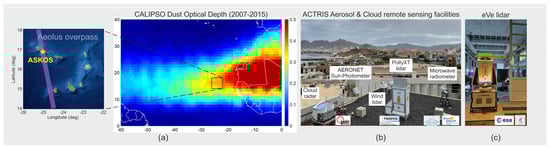
Figure 1.
(a) ASKOS site in Cabo Verde, Aeolus Friday afternoon orbit, and dust optical depth (DOD) over Cabo Verde, based on CALIPSO 2007-2015 measurements, (b) ACTRIS aerosol and cloud remote sensing facilities employed, and (c) ESA’s reference lidar eVe during ASKOS.
2. ASKOS Measurements
Since 2021, a complete aerosol and cloud remote sensing facility of ACTRIS (Aerosol, Clouds, and Trace Gases Research Infrastructure) has been operated 24/7 at the Ocean Science Center in Mindelo (OSCM), and this facility keeps operating to date. The instrumentation includes a multiwavelength Raman-polarization-water vapor lidar (PollyXT), an AERONET sun-photometer, a scanning Doppler wind lidar (HALO), a microwave radiometer, and a 94 GHz cloud radar belonging to the ESA fiducial reference network (FRM4Radar). Additionally, the eVe lidar, which is the ESA’s reference lidar for the cal/val of Aeolus aerosol products, operated during the intensive campaign periods [2]. In 2022, the measurements were enhanced with the polarization lidar WALL-E, designed to measure the particle preferential orientation [3], measurements of atmospheric electricity (electric field and electric charge from a ground-based field mill electrometer and balloon-borne atmospheric electricity sensors) [4], radiosondes, and radiation measurements (two pyranometers and a pyrheliometer for total, diffuse and direct irradiance). In addition, the ASKOS dataset was enriched by airborne in situ measurements onboard a light aircraft (September 2021/2022) and UAVs (June 2022) for enhanced aerosol characterization measurements. Specifically, in June 2022, the CyI conducted 25 UAV vertical flights equipped with optical particle counters (OPCs) for fine- and coarse-mode height-resolved observations of particle size distribution, as well as backscatter sondes (COBALDs). Particles within the dust layers were collected through impactor samples onboard the UAVs [5]. In September 2021 and 2022, the JATAC CAWA-AW component [6] conducted 10 light aircraft flights equipped with continuous light absorption photometers (CLAPs) providing measurements of particle light absorption coefficient at three wavelengths, optical particle size spectrometers (OPSSs) for particle size distributions above 0.3 μm diameter separately for fine and coarse mode, a nephelometer for aerosol light scattering and backscattering coefficients, and a pyranometer for the total and diffuse solar irradiance. The light aircraft and the UAVs collected in situ measurements at 0–3 km and 0–5 km above sea level (ASL), respectively, collocated with the ASKOS remote sensing measurements.
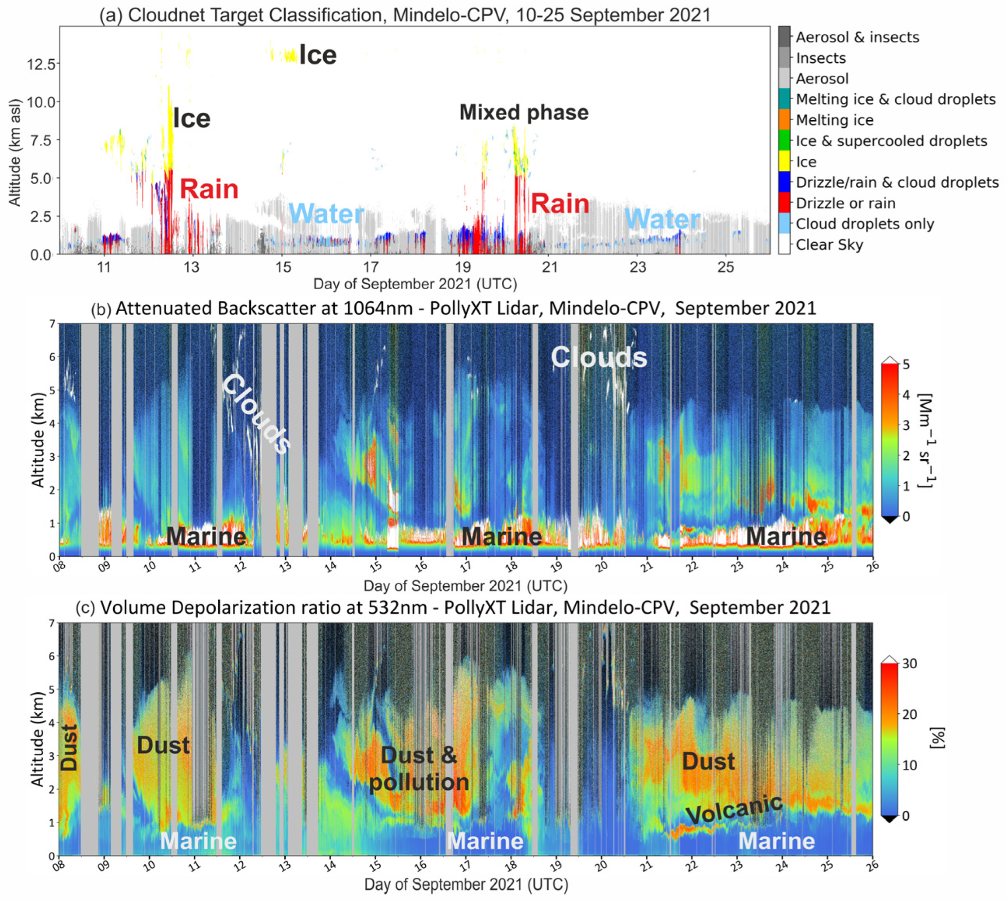
An overview of the atmospheric conditions observed during the ASKOS experiment is presented herein. Figure 2 presents the aerosol, cloud, and precipitation conditions during September 2021. Several low marine-level clouds were observed, including precipitation in some of the cases (top panel). Clouds were also formed at the top of the dust layers, between 5 to 11 km, observed with mixed phase layers embedded in them, resulting in drizzle and rain events. These events were outflows of convective systems in the broader region. Regarding the observed aerosols, they included particles in the marine boundary layer (MBL) in altitudes up to 1 km, topped with the Saharan air layer (SAL) reaching up to 6 km altitude (in the middle and lower panel of Figure 2). The amount, height, and depth of SAL varied during the campaign periods, providing a wide variety of aerosol conditions. The first dust event (10–12 September) was very homogeneous, with an AOD of up to 0.7, and the second dust event (14–18 September) reached a very large AOD (up to 1.5) and was mixed with pollution particles. The last dust event (21–26 September) reached an intermediate AOD of 1 and was observed along with volcanic aerosols. The volcanic aerosols originated from the Cumbre Vieja volcano eruption on 19 September 2021 on the island of La Palma, Canary Islands, and reached the observational site a few days later. The volcanic plume was observed within the marine boundary layer, where it was mixed with marine aerosols, and at 2–3 km altitude where it was detected mixed with the dust particles.
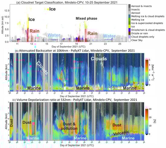
Figure 2.
Overview of (a) the Cloudnet target classification, (b) the PollyXT lidar backscatter coefficient at 1064 nm, and (c) the PollyXT volume depolarization ratio at 532 nm, as measured at the ASKOS site during the September 2021 operations.
Figure 3 presents the aerosol, cloud/precipitation, and radiation measurements during June and September 2022. In June 2022, three dust events were observed, all with an AOD of less than 0.7. We encountered very frequently the presence of clouds at the top of the MBL, frequently resulting in precipitation. Unfortunately, the clouds limited the capabilities of the remote sensing instruments to monitor the SAL properties. Strong wind speeds were also observed at the site (up to 25 m/s), reducing the ability of the UAVs to operate or reach higher altitudes. Despite these difficulties, 25 UAV flights were conducted, of which 11 were during the nighttime.
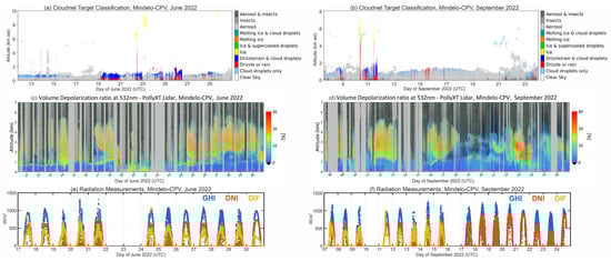
Figure 3.
Cloudnet target classification (a,b), PollyXT volume depolarization ratio at 532 nm (c,d), and surface radiation measurements (global horizontal irradiance—blue, direct normal irradiance—red, and diffused irradiance—yellow) (e,f) as measured during ASKOS in June/September 2022.
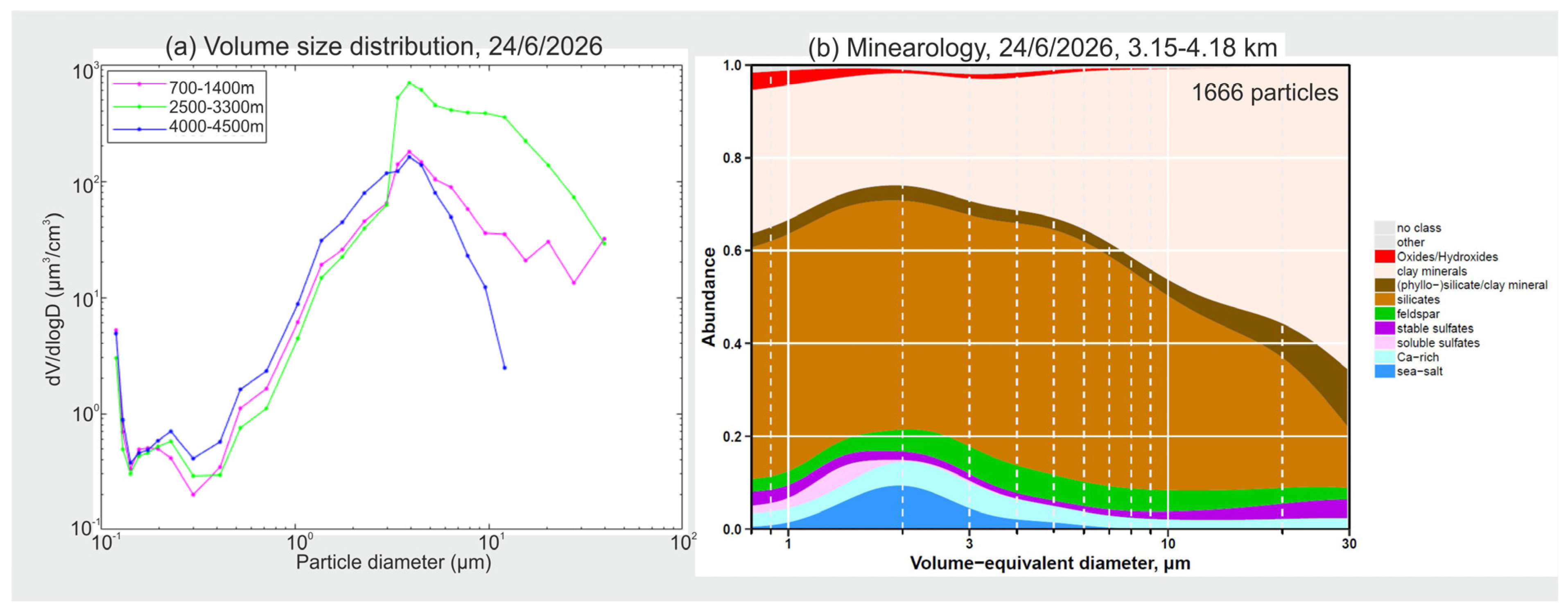
From the in situ measurements collected, the altitude of the MBL was mainly observed from the ground up to about 1.0 km, whereas during most of the flights, high concentrations of dust particles were found between 1.5 and 5.0 km. The results obtained from the OPCs show the presence of particles with a radius of up to 20 μm within the MBL and up to 40 μm within the SAL (Figure 4a). Further information on the morphology and mineralogy of the observed particles will be provided by offline analysis of the collected samples under a scanning electron microscope (SEM) (Figure 4b). The COBALD backscatter sonde observations alongside ground-based lidar measurements agree on the presence of non-spherical particles within the dust layers.

Figure 4.
(a) High−altitude volume size distributions in three layers, obtained with the POPS and UCASS instruments flown on the CoBi UAV on 24 June 2022. The presence of large dust particles is highlighted. (b) Mineralogy of the observed particles from the layer 3.15–4.8 km on the same flight.
In September 2022, three dust events were observed, two with an AOD of less than 0.7 and one with an AOD of up to 1.0 (22–24 September). The last event was sampled additionally from the NASA DC8 aircraft from the CPEX-CV campaign [7]. During this dust event, the global horizontal irradiance and the direct normal irradiance at the Midelo site were reduced by 25% and 50%, respectively (in comparison to 2 days earlier).
3. Applications
The unprecedented ASKOS dataset of synergistic measurements in the region will be used together with the satellite products of Aeolus, primarily for the validation and enhancement of satellite products, science applications, and data assimilation. The validation and enhancement of satellite products include the cal/val of the Aeolus aerosol and wind products [8]; the enhancement of satellite products (e.g., lidar ratio, particle linear depolarization ratio, dust deposition, mass concentrations); and the harmonization of the measurements on the ground and in the air provided by different systems through different measurement techniques (e.g., HSRL vs. Raman lidar products, in situ vs. lidar SSAs, in situ vs. lidar dust mixing ratio, dust mass, and number concentrations). Science applications include the investigation of atmospheric dust processes possibly affecting the retainment of super-coarse dust particles at the SAL at greater distances than anticipated from most model simulations [9]. Processes under investigation include the effect of dust shape, electrostatic forces, particle orientation, and dynamics in dust transport. Other studies include the investigation of the aerosol effect on cloud formation, the impact of aerosol and cloud radiation, the study of aerosol microphysics, and the volcanic ash advection. Applications for data assimilation and impact assessment include the assessment of the Aeolus impact assimilation on dust transport models; the assessment of the impact of the missing cross-polar component from Aeolus on aerosol assimilation; and the assessment of the simultaneous assimilation of the aerosol and wind products of Aeolus. All of the assimilation runs will be validated against the ASKOS measurements. Additionally, by combining the ASKOS measurements with the JATAC airborne measurements, the capability of the ASKOS site to represent the atmospheric conditions in the broader area will be investigated.
4. Review and Outlook
The ASKOS campaign at Cabo Verde during summer and autumn 2021 and 2022 provided a diverse dataset for the cal/val and enhancement of ESA Aeolus products and the characterization of aerosols, clouds, precipitation, and their radiative effect. We present an overview of the acquired observations, providing a wealth of information on the atmospheric state and processes in the area. Moreover, we discuss possible synergies and applications for addressing a wide range of scientific objectives. The methodology and scientific findings of ASKOS will be valuable in formulating effective cal/val activities for the ESA EarthCARE mission, scheduled to launch in April–Summer 2024. EarthCARE will provide observations of aerosols, clouds, and radiation, aiming to enhance the characterization of aerosols and clouds, along with their interactions, and the related effect on radiation and climate.
Author Contributions
Conceptualization, V.A. and E.M.; investigation, E.M.; data collection and campaign logistics, E.M., P.P., I.T., A.T., V.D., D.K., N.S., I.M., V.S.-M., H.B., A.F., R.P., A.N., F.M., M.K., A.P., G.M., C.L.R. and N.R.; data curation, E.M., I.T., E.P., D.K., H.B., M.K. and A.S.; writing—original draft preparation, E.M.; writing—review and editing, all; visualization, E.M., I.T., D.K., E.P., H.B., M.K. and A.S.; supervision, E.M. and V.A.; project administration, E.M. and V.A.; funding acquisition, V.A., E.M. and A.T.; coordination of the UAV flights, F.M., M.K., A.P., C.L.R. and N.R.; process and analysis of the UAV-borne datasets, M.K; process and analysis of the UAV samples: K.K. and A.S.; light aircraft measurements: G.M. and J.Y.D. All authors have read and agreed to the published version of the manuscript.
Funding
The ASKOS campaign was funded by the ASKOS ESA project (contract nr. 4000131861/20/NL/IA) and the D-TECT ERC Consolidator Grant (ERC-CoG grant agreement 725698). This research was financially supported by the PANGEA4CalVal project (grant agreement 101079201) funded by the European Union  , the Hellenic Foundation for Research and Innovation (H.F.R.I.) under the “3nd Call for H.F.R.I. Research Projects to support Post-Doctoral Researchers” (project acronym: REVEAL; project number: 07222), the German Federal Ministry for Economic Affairs and Energy (BMWi, grant no. 50EE1721C), and the German Federal Ministry of Education and Research (BMBF, grant no. 01LK1603A). E. Proestakis was supported by the AXA Research Fund for postdoctoral researchers under the project entitled “Earth Observation for Air-Quality—Dust Fine-Mode—EO4AQ-DustFM”. A. Gkikas acknowledges support by the Hellenic Foundation for Research and Innovation (H.F.R.I.) under the “2nd Call for H.F.R.I. Research Projects to support Post-Doctoral Researchers” (project acronym: ATLANTAS, project number: 544). The UAV activities also received funding from the EU’s Horizon 2020 R&I program (grant agreement No. 856612) and the Cypriot Government.
, the Hellenic Foundation for Research and Innovation (H.F.R.I.) under the “3nd Call for H.F.R.I. Research Projects to support Post-Doctoral Researchers” (project acronym: REVEAL; project number: 07222), the German Federal Ministry for Economic Affairs and Energy (BMWi, grant no. 50EE1721C), and the German Federal Ministry of Education and Research (BMBF, grant no. 01LK1603A). E. Proestakis was supported by the AXA Research Fund for postdoctoral researchers under the project entitled “Earth Observation for Air-Quality—Dust Fine-Mode—EO4AQ-DustFM”. A. Gkikas acknowledges support by the Hellenic Foundation for Research and Innovation (H.F.R.I.) under the “2nd Call for H.F.R.I. Research Projects to support Post-Doctoral Researchers” (project acronym: ATLANTAS, project number: 544). The UAV activities also received funding from the EU’s Horizon 2020 R&I program (grant agreement No. 856612) and the Cypriot Government.Institutional Review Board Statement
Not applicable.
Informed Consent Statement
Not applicable.
Data Availability Statement
The ASKOS data are currently available upon request and will be publicly available by September 2023 through the EVDC portal (ESA Validation Data Center; evdc.esa.int).
Acknowledgments
The authors would like to acknowledge ACTRIS (www.actris.eu) for the data collection, calibration, processing, and dissemination. Many thanks are given to Cesaria Evora International Airport and the Ocean Science Centre Mindelo for their support, which has been decisive in the success of the campaign.
Conflicts of Interest
The authors declare no conflict of interest.
References
- Fehr, T.; McCarthy, W.; Amiridis, V.; Baars, H.; von Bismarck, J.; Borne, M.; Chen, S.; Flamant, C.; Marenco, F.; Knipperz, P.; et al. The Joint Aeolus Tropical Atlantic Campaign 2021/2022 Overview—Atmospheric Science and Satellite Validation in the Tropics. In Proceedings of the EGU General Assembly 2023, Vienna, Austria, 24–28 April 2023. EGU23-7249. [Google Scholar] [CrossRef]
- Paschou, P.; Siomos, N.; Tsekeri, A.; Louridas, A.; Georgoussis, G.; Freudenthaler, V.; Binietoglou, I.; Tsaknakis, G.; Tavernarakis, A.; Evangelatos, C.; et al. The eVe reference polarisation lidar system for the calibration and validation of the Aeolus L2A product. Atmos. Meas. Technol. 2022, 15, 2299–2323. [Google Scholar] [CrossRef]
- Tsekeri, A.; Amiridis, V.; Louridas, A.; Georgoussis, G.; Freudenthaler, V.; Metallinos, S.; Doxastakis, G.; Gasteiger, J.; Siomos, N.; Paschou, P.; et al. Polarization lidar for detecting dust orientation: System design and calibration. Atmos. Meas. Technol. 2021, 14, 7453–7474. [Google Scholar] [CrossRef]
- Daskalopoulou, V.; Mallios, S.A.; Ulanowski, Z.; Hloupis, G.; Gialitaki, A.; Tsikoudi, I.; Tassis, K.; Amiridis, V. The electrical activity of Saharan dust as perceived from surface electric field observations. Atmos. Chem. Phys. 2021, 21, 927–949. [Google Scholar] [CrossRef]
- Kezoudi, M.; Marenco, F.; Papetta, A.; Keleshis, C.; Ryder, C.; Kandler, K.; Girdwood, J.; Stopford, C.; Wienhold, F.; Gao, R.S.; et al. Profiling Saharan Airborne Dust with UAV-based in-situ Instrumentation during the ASKOS Experiment in Cape Verde. In Proceedings of the EGU General Assembly 2023, Vienna, Austria, 24–28 April 2023. EGU23-17090. [Google Scholar] [CrossRef]
- Díez, J.Y.; Bervida, M.; Drinovec, L.; Žibert, B.; Lenarčič, M.; Marinou, E.; Paschou, P.; Siomos, N.; Baars, H.; Engelmann, R.; et al. Airborne In-situ Measurements during JATAC/CAVA-AW 2021/2022 campaigns—First Climate-Relevant Results. In Proceedings of the EGU General Assembly 2023, Vienna, Austria, 24–28 April 2023. EGU23-15901. [Google Scholar] [CrossRef]
- Nehrir, A.; Ferrare, R.; Collins, J.; Grimley, R.B.; Crosbie, E.; Marinou, E. Overview of the High Altitude Lidar Observatory (HALO) water vapor DIAL and High Spectral Resolution Lidar observations during the summer 2022 CPEX-CV Campaign. In Proceedings of the EGU General Assembly 2023, Vienna, Austria, 24–28 April 2023. EGU23-17250. [Google Scholar] [CrossRef]
- Paschou, P.; Siomos, N.; Marinou, E.; Gkikas, A.; Idrissa, S.M.; Quaye, D.T.; Attannon, D.D.; Meleti, C.; von Bismarck, J.; Fehr, T.; et al. Validation of the Aeolus L2A products with the eVe lidar during ASKOS/JATAC campaign. In Proceedings of the EGU General Assembly 2023, Vienna, Austria, 24–28 April 2023. EGU23-14445. [Google Scholar] [CrossRef]
- Drakaki, E.; Amiridis, V.; Tsekeri, A.; Gkikas, A.; Proestakis, E.; Mallios, S.; Solomos, S.; Spyrou, C.; Marinou, E.; Ryder, C.L.; et al. Modeling coarse and giant desert dust particles. Atmos. Chem. Phys. 2022, 22, 12727–12748. [Google Scholar] [CrossRef]

Disclaimer/Publisher’s Note: The statements, opinions and data contained in all publications are solely those of the individual author(s) and contributor(s) and not of MDPI and/or the editor(s). MDPI and/or the editor(s) disclaim responsibility for any injury to people or property resulting from any ideas, methods, instructions or products referred to in the content. |
© 2023 by the authors. Licensee MDPI, Basel, Switzerland. This article is an open access article distributed under the terms and conditions of the Creative Commons Attribution (CC BY) license (https://creativecommons.org/licenses/by/4.0/).