1. Introduction
Since the outbreak of COVID-19, local hiking, proximity tourism, and rural development have gained new visibility due to their positive impact on health and well-being [
1,
2]. Indeed, as illustrated in recent research [
3,
4], the (re)discovery of cultural and natural amenities in rural and natural areas, as well as the renewed interest in local food and wine traditions, can be key drivers for local excursions and out-of-town trips from urban areas towards peripheral territories. Planning out-of-town trips and short tourism stays integrating nature, gastronomic experiences, and culture, however, is not easy, as their success depends on the relationships that tourists and hikers establish with a plurality of stakeholders and value holders [
3]. Furthermore, the tourism attractiveness of the localities is indirectly related to the level of local development [
3,
4]. Consequently, while paying attention to the need to contrast depopulation processes through adequate local welfare policies and to complete transport infrastructures in peripheral territories, some elements to be considered in the design of an attractive local tourism offer are, at least, the following: the need to develop a cultural approach to local development, capable of generating benefits for local communities and enhancing traditions within clusters of production activities in which tourism can play a significant, albeit not exclusive, role [
5]; the opportunity to develop forms of supra-local cooperation to compensate for the existing shortcomings in public services and tourist accommodation [
6,
7]; the need to operate at least on a provincial scale to intercept the demand for tourist and agri-food products and services from residents in urban areas [
3]; the opportunity offered by the development of the new economy to promote the local and regional supply of tourist and agri-food local value-chains through digital marketing tools [
3]. Based on these premises, a stream of literature concerning the implementation of a local tourism offer in the inner areas of Italy was analyzed, and a potential research gap concerning the contextualization of general results with respect to more specific geographic contexts was observed. Specifically, well-established literature investigates whether local tourism may contribute to the socioeconomic development of the localities [
8,
9,
10,
11,
12]. Besides some negative concerns, it is worth noting how in many local development strategies, tourism-related activities play a major, albeit not exclusive, role. Additionally, numerous authors have recently explored the opportunity of revitalizing rural development and local agri-food value chains through the implementation of a culturally sustainable agri-food and tourism offer in rural and natural areas [
5,
11,
13,
14,
15,
16]. Specifically, sustainable local tourism emerges as an important driver of territorial development and as an activator of nested markets for clusters of typical agri-food products that may eventually lead to the design and implementation of supra-local networks of commercialization involving “consumer niches” [
14,
15]. Throughout the mediation of culturally sustainable tourism, the agricultural sector can trigger a local development process based on the production of high-quality agri-food products and business diversification (agritourism, direct sales, processing) [
5,
11]. Finally, culturally sustainable tourism enables the rural community to strengthen its internal identity, resilience, and sustainability, as well as its external image [
16].
Based on these premises, this research focuses on the development of local tourism initiatives in the Province of Rieti, which is part of the Latium Region (Italy). The latter is characterized by a high territorial heterogeneity along multiple dimensions (nature, history, population, economic development, etc.) and by the relevance of its center, the city of Rome, which, while being the capital of Italy, is also a world tourist destination. In recent history, Rome has attracted population and resources from the rest of the region, polarizing economic activities and generating depopulation trends in peripheral areas. However, the regional territory is still rich in natural and cultural amenities, as well as in local food and wine traditions [
17,
18,
19,
20], that may become part of a polycentric and more balanced process of local development. Furthermore, a considerable part of the regional territory is included in the so-called inner areas. The latter are peripheral (often rural and natural) areas that, being far from the provincial poles of services, often lack adequate access to public infrastructures and welfare services (mobility, health, and education) [
6,
7]. Specifically, Latium Region hosts four project areas included in the National Strategy for Inner Areas: Alta Tuscia and Antica Città di Castro, Monti Reatini, Monti Simbruini Terre d’Aniene, and Valle di Comino [
21,
22,
23,
24].
In recent research, the tourism attractiveness of a sample of small municipalities at the borders of Ciociaria valley (a vast area located in the inner part of Southern Latium that mostly overlaps with the Province of Frosinone) was estimated [
3], and then a similar analysis was developed at Municipal level for the Province of Viterbo [
4]. As for the provincial territories already examined, a quantitative analysis of the tourism attractiveness of the localities could not be found for the Province of Rieti. Instead, being endowed with an abundant cultural, rural, and natural heritage, and due to the lower congestion and a more human-centered daily life, the Province of Rieti is an ideal territory for the development of initiatives linked to hiking and proximity tourism centered on out-of-town trips, daily excursions, and second-home tourism. By satisfying an external demand for tourism goods and services, residents in small rural municipalities can accumulate enough resources to activate local development paths driven by culturally sustainable local tourism, capable of contributing to the revaluation of the local heritage and transforming, over time, out-of-town trips and short tourism stays into longer-term stays with broader objectives. By using proximity tourism as a driver for rural development and local entrepreneurship, local administrations can promote bottom-up entrepreneurial initiatives centered on the creation of new products and services from the abundant natural, rural, cultural, and human heritage of the province. By creating entrepreneurship and quality employment in the peripheral territories and by supporting these initiatives through public policies capable of enhancing at the same time the polycentrism of the inner areas and the centrality expressed by the Municipality of Rieti, the local administrations can alleviate the phenomena of abandonment and depopulation that seem to characterize at least part of the provincial territories [
6,
23,
25]. Specifically, the inner areas (and, overall, the whole Province) need to overcome the inadequate road infrastructures, the lack of an integrated local public transport service, the scarce accessibility of the whole Province, the insufficient welfare services for the elders and for the whole population, the low level of schooling of the population [
23].
Based on these premises, the goal of this research is to explore through a desk analysis the territory of the Province or Rieti to identify the most attractive local destinations—that is, those municipalities that, leveraging on the existence of a mix of local countryside capital [
26], may develop a culturally sustainable tourist offer [
27]—while controlling for elements that can limit the tourism potential of the localities. Specifically, the quantitative analysis illustrated in
Section 2 and
Section 3 answers the following questions: what are the most attractive destinations for out-of-town trips in the Province of Rieti? What territorial factors may negatively affect local tourism attractiveness? The objective of the research is of interest in that it identifies an opportunity to align the private interest of the urban residents of the Metropolitan City of Rome in enjoying out-of-town trips in attractive rural and natural areas with the right of the Province of Rieti’s inhabitants of benefitting of improved local welfare and of being involved in local processes of culturally sustainable economic development [
27]. Based on the results of the quantitative analysis, a set of policy recommendations is elaborated, which may contribute to assessing where and how out-of-town trips and daily excursions from urban centers to rural and natural areas can be considered elements of a culturally sustainable local development.
2. Materials and Methods
Building on the issues highlighted in
Section 1, the research proposes an assessment of the tourism potential (here intended as a mix of natural, food and wine, and cultural resources and traditions that could become resources in the design and implementation of a local tourism supply chain) and of the territorial development (to the scope of this research, a mix of local availability of services of general interest and accessibility from the Metropolitan City of Rome) of the municipalities of the Province of Rieti. The assessment was implemented using the data made available by the Istat Statistical Atlas of Municipalities [
28], integrated with the data obtained through online research on Google Maps and other websites of interest. The analysis of the data collected is intrinsically multidimensional, and the methodology used to design a composite index articulated in two domains (territorial attractiveness and territorial development) has been partially adapted from [
14,
15] and already implemented in [
3,
4]. Rather than focusing on the “nesting process”, that is, on the cultural sustainability and on the level of endogenous and exogenous integration of the local agri-food system, this research adopts the perspective of the consumers, that are the urban resident interested in experiencing a variety of amenities (natural itineraries, museums, food and wine traditions, typical food products, etc.) within the limited time of an out-of-town trip or a short tourism stay.
The quantitative analysis has been implemented according to the following procedure: (i) historical and geographical analysis of the Province of Rieti aimed at identifying elements of tourism attractiveness and to make an overall assessment of the level of territorial development; (ii) construction of a database illustrating, for each municipality, the local availability of countryside capital [
26], here intended as a mix of natural and cultural resources, food and wine traditions, and typical agri-food products, and the level of territorial development, here intended as a mix of demographic characteristics, territorial relations, and accessibility from the Metropolitan City of Rome; (iii) design of a composite index of tourism attractiveness and territorial development as a weighted average of elementary indexes; (iv) computation, for each municipality, of a score for each elementary index and for the two domains (tourism attractiveness and territorial development); (v) elaboration of graphical outputs and discussion of results. In the remainder of this section, the first three steps are illustrated in more detail, while the remaining steps are presented in
Section 3.
- (i)
A brief historical and geographical analysis of the Province of Rieti
The Province of Rieti is bordered to the west by the province of Viterbo and the metropolitan city of Rome, to the north by the provinces of Perugia and Terni (Umbria), to the northeast by the province of Ascoli Piceno (Marche) and to the east by the provinces of L’Aquila and Teramo (Abruzzo). The provincial territory is predominantly mountainous and includes the Sabini Mountains, the Reatini Mountains, Mount Terminillo, the Laga Mountains, Mount Nuria and Mount Giano, the Carseolani Mountains, the Cicolano Mountains, and the Duchessa Mountains.
The Province of Rieti mostly overlaps with a homogeneous cultural area (the ancient Sabina). Although the first inhabitants of Sabina were the Aborigines, who founded their capital Lista and numerous other cities, the history of Sabina is more closely connected to that of the Sabines [
19]. Their coexistence of the latter with the Romans was characterized by alternating peaceful and hostile relations until the Sabines were conquered by the Romans in 290 BC. During the Middle Ages, Sabina was divided between Spoleto and Rome, and during the 9th century, the inhabitants of the Sabina built several castles to defend themselves against Saracen attacks. With the birth of the State of the Church, Sabina was governed first by the pontiff himself, then by various noble families, and then again by the pontiff. Since then, Sabina remained divided until reunification was achieved with the establishment of the province of Rieti in 1927 [
19].
The territory is rich in well-preserved natural areas (the three valleys of Velino, Turano, and Salto) and rural areas (lower Sabina and the valley of Rieti), often endowed with an unexploited potential for cultural and socioeconomic development. Specifically, the Province of Rieti hosts many well-preserved historical villages (e.g., Cittareale, Cittaducale, Fara in Sabina, Greccio, Leonessa, Poggio Mirteto, Rieti, and Rocca Sinibalda), archeological sites (e.g., Aquae Cutiliae, Archeological site of Poggio Sommavilla, Cures Sabini, and Forum Novum), and cultural itineraries (e.g., la Via di Francesco, Cammino delle Terre Mutate, and Cammino di San Benedetto). Additionally, the Province hosts numerous natural reserves (National Park Gran Sasso e Monti della Laga, Regional Natural Reserve Monti della Duchessa, Regional Natural Reserve Monti Navegna e Cervia, Regional Natural reserve Lago Lungo Ripa Sottile, Regional Natural Reserve Nazzano, Tevere-Farfa, Dolina del Revotano, Natural Monument Gole del Farfa, and Regional Natural Reserve Monti Lucretili) and water resources (Salto and Turano Lakes, Duchessa Lake, Lago lungo, Paterno Lake, Rascino Lake, Lake of Scandarello, Ventina Lake, Gole del Velino, Santa Susanna’s springs, Peschiera springs, and Velino springs). Finally, part of the province was damaged by the 2016 earthquake in Central Italy, and Amatrice and Accumoli were entirely destroyed.
While the heritage of the Province of Rieti is well-preserved and diversified, the provincial territory is instead characterized by relevant socioeconomic imbalances and scarce accessibility. Specifically,
Table 1 illustrates the main characteristics of the municipalities located in the Province of Rieti according to the data published by the Italian Agency for Territorial Cohesion for 2014 and 2020 [
29,
30]. Compared to the data available and the criteria adopted in 2014, the 2020 data highlight a slight depopulation (−2.47%) and a significant reduction in territorial gaps, as several intermediate and peripheral municipalities (class D and E) are now part of the territorial belt (class C). It is worth noting how the intermediate and peripheral territories are mainly located in the northern and eastern parts of the Province, that is, along the three valleys of Velino, Turano, and Salto. This is the territory of the project area of Reatini Mountains [
23], which now includes 31 municipalities: 29 out of 37 municipalities of the inner areas located in the Province and 2 municipalities in the belt area. Overall, this is an area of 1623 km
2 at risk of depopulation, inhabited by 31,251 residents (according to [
23], they were 34,853 in 2011). In this perspective, the Province of Rieti is characterized by a marked dualism, with the center of Rieti and its belt municipalities contrasting with the large inner area of Reatini Mountains. Overall, on a more aggregated scale, the Province of Rieti manifests some degree of marginality with respect to the metropolitan area of Rome.
- (ii)
Data collection
Table 2 illustrates the data collected. After a brief analysis of the data published on the Istat Statistical Atlas of Municipalities [
28] and of the data available on Google Maps and other websites of interest, fourteen variables were included in the analysis. The selection of variables reflects, on the one hand, the interest in the identification of a mix of elements defining the local countryside capital [
26] and the development of tourism-related businesses, and, on the other hand, an interest in defining the level of local socioeconomic development and of accessibility from the Metropolitan City of Rome.
Concerning measures, four variables are represented using a dichotomic variable (NTM and CTM are related to the identification of at least one cultural or natural amenity within the municipal territory; RTQ indicates if the municipality has been included in the “crater” of the 2016 Earthquake, and PTR indicates if the municipality can be reached from downtown Rome by public transport in a reasonable time), six variables are represented using a positive discrete variable (ACM indicates the number of authorized for accommodation agrotourism enterprises, ARS indicates the number of authorized agrotourism enterprises for restaurant services, LPR indicates the number of local producers of typical food products, LTR indicates the number of local enterprises processing typical food products, LTB indicates the number of local hospitality businesses, while DMS indicates the number of local residents), three variables are represented using a continuous positive variable (DPS indicates the estimated average distance of the municipality from the pole of services, TTR indicates traveling time from downtown Rome measured in minutes, and TRL indicates the average distance from the downtown Rome measured in kilometers), and variable is represented using a continuous index (DPP indicates the 2009–2019 population change measured as a change in the population index).
- (iii)
Design of a composite index of tourism attractiveness and territorial development
Table 3 illustrates the design of the composite index of tourism attractiveness and territorial development. Al already mentioned, the methodology has been adapted from [
14,
15] and has already been used in [
3,
4] for similar analyses concerning the provinces of Viterbo and Frosinone (Latium). However, the selection of variables, the structure of the composite indicator, and the scoring rules adopted in this research are slightly different from those used in [
3,
4]. Specifically, in this research, seven out of the fourteen variables collected contribute to the definition of the five elementary indices of tourist attractiveness (natural amenities, cultural amenities, agritourism development, local typical food products, tourist accommodation, and restaurants), and seven contribute to the definition of the two elementary indices of territorial development (sociodemographic development and accessibility). A polarity was attributed to each variable, and then a criterion was adopted to transform the observed values into scores. As already mentioned, in the attribution of the scores, it was deemed appropriate to establish maximum and minimum thresholds (hence, truncating the scoring functions) to limit the influence of outliers and to bring the assessment closer to the perception of a representative tourist living in the Metropolitan City of Rome willing to make an out-of-town trip or a daily excursion in the Province of Rieti.
The selected variables received scores between zero and one (so it was not necessary to normalize the scores obtained in the first aggregation step), either by sorting the modalities according to the polarity assigned to the variable or by applying a truncated scoring function to the observed data. Specifically, the variables considered for assessing tourist attractiveness all have a positive polarity since, besides their intrinsic value as part of the local heritage, they are tourist amenities (natural, cultural resources and products of rural development that can be exploited to trigger a culturally sustainable tourist-related local development) [
3,
4]. In relation to the elements of natural value, considering the needs of a tourist interested in an out-of-town trip or a daily excursion, the presence of at least one element of interest (a protected natural area, a spring, or a lake) was positively evaluated [
3,
4]. Similarly, considering cultural amenities, the presence of at least one element of interest (archeological areas, historical villages, or museums) was positively evaluated [
3,
4]. Concerning museums, the number of annual visitors was considered irrelevant, as all museums in the Province of Rieti did not attract a high number of visitors. Concerning rural development, a positive score was given to the presence of agritourism farms, and the presence of more than five farms in total (three agrotourism restaurants) was considered superfluous [
3,
4].
Similarly, for the production and processing of typical agri-food products, a positive score was attributed to the presence of local producers, and this score was increased in those territories where the presence of processing enterprises was also observed [
3,
4]. Due to the limited scope of a short tourism experience, the presence of more than ten farms producing goods was considered superfluous [
3,
4]. Finally, for tourist accommodation, a positive score was given to the presence of tourism businesses (hotels, B&B, camping, etc.) in the area as possible evidence of a local development strategy focused on tourism, and the presence of more than fifteen hospitality structures was considered superfluous [
3,
4].
On the other hand, the variables considered to assess the level of territorial development all have negative polarity, except for demographic size (
DMS). Specifically, it has been appreciated as a tourism destination having at least a demographic mass of one thousand inhabitants, and it has been considered superfluous, a demographic mass of more than ten thousand inhabitants, as a proxy for the services that may be available on-site [
3,
4]. Similarly, the absence of depopulation phenomena (regardless of the level of demographic growth) was considered a sign of local dynamism, while a negative score was assigned according to the depopulation rate observed in the 2009–2019 period until the maximum observed threshold of 30% was reached [
3,
4]. Regarding the travel from Rome by car, a traveling time of 45 min was considered negligible, while a traveling time of more than two hours was considered prohibitive. Similarly, for the distance to Rome, less than 30 km was considered negligible, while more than 120 km was considered prohibitive [
3,
4]. Furthermore, the possibility of reaching the tourist destination using public transport (train and/or bus within a journey of at most two hours) was assessed positively, but a positive score was also assigned in case of long journeys (as the locality is connected by public transport and tourists without a car may decide to explore it by finding an accommodation for the night) [
3,
4]. Finally, the municipalities affected by the 2016 earthquake of Amatrice received a penalty of 0.3 on the score of socioeconomic development, while Amatrice and Accumoli, being destroyed by the earthquake, received a penalty of 1.
For each municipality, the scores computed for the elementary indices were aggregated by calculating their weighted sum using the system of weights illustrated in
Table 3. Linear combinations of scores between zero and one obtained using weighting systems that sum to one still return scores between zero and one. Therefore, being interested primarily in the absolute scores obtained, it was not necessary to normalize the data also when calculating the aggregated scores [
3,
4]. Based on these premises, the two scores for tourism attractiveness and territorial development have been computed as
It is worth noting how the weights were assigned according to two criteria: (i) weights were initially assigned by maintaining a balanced relevance among the variables and the indicators; (ii) then, relevant items received a higher weight. As an example, the elementary indicators of tourism attractiveness initially received a uniform weight equal to 0.2; then, considering the scope of this research, the relatively higher relevance of TRL compared to RDV, the weight of the former was increased by 0.1, and the weight of the latter was reduced accordingly. Similarly, considering the level of accessibility, initially, equal weight was given to TTR, TRL, and PTR, then, as data suggested that only a limited number of municipalities could be reached in a reasonable time using public transports (i.e., PTR “rewards” only a few municipalities, and penalizes all the remaining one), a higher and equal score of 0.4 was assigned to TTR and TRL, while the score of PTR was reduced accordingly. As a result, the system of weights is rather heterogenous, as the weights associated with each item range from 0.3 (LTB) to 0.03 (LTR). It is worth noting how RTQ is excluded from the evaluation of accessibility and directly penalizes the overall TED score (implicitly, therefore, RTL has a weight of −1 on the overall TED score). Finally, it is worth noting that a confirmatory factor analysis (CFA) may provide evidence in support of the weights selected; however, it may also dilute their theoretical coherence and their respondence to the purpose of the analysis.
3. Results
In this section, the scores computed for each municipality are reported (see
Table 4) and briefly commented on using descriptive statistics and graphical representations (see
Figure 1). The average score computed for the Tourism Attractiveness index (
TOA) is 0.50, and the coefficient of variation is 0.47. The maximum score obtained for
TOA is 1.00 (Rieti and Castelnuovo di Farfa), while the maximum score is 0.06 (Frasso Sabino). Scores above 0.80 are also obtained by Montopoli in Sabina (1.00), Cittaducale (1.00), Contigliano (0.91), Leonessa (0.83), Fara in Sabina (0.80), while scores below 0.10 are also obtained by Torricella in Sabina (0.07), Poggio San Lorenzo (0.10), and Toffia (0.10). The scores distribution is slightly positively skewed (the coefficient of asymmetry is 0.16) and slightly platykurtic (the coefficient of kurtosis is −0.62).
The average score computed for the Territorial Development index (TED) is 0.42, and the coefficient of variation is similar to that one computed for the Territorial Development index (0.46). The maximum score obtained for TED is 0.75 (Montopoli in Sabina and Fara in Sabina), while the minimum score is 0.00 (Accumoli and Amatrice). Scores above 0.70 are also obtained by Poggio Mirteto (0.74), Forano (0.74), Stimigliano (0.73), Scandriglia (0.72), and Poggio Nativo (0.71), while scores below 0.10 are also obtained by Cittareale (0.01), Borbona (0.04), Leonessa (0.04), and Micigliano (0.06). The scores distribution is slightly positively skewed (the coefficient of asymmetry is −0.33) and slightly platykurtic (the coefficient of kurtosis is −0.41).
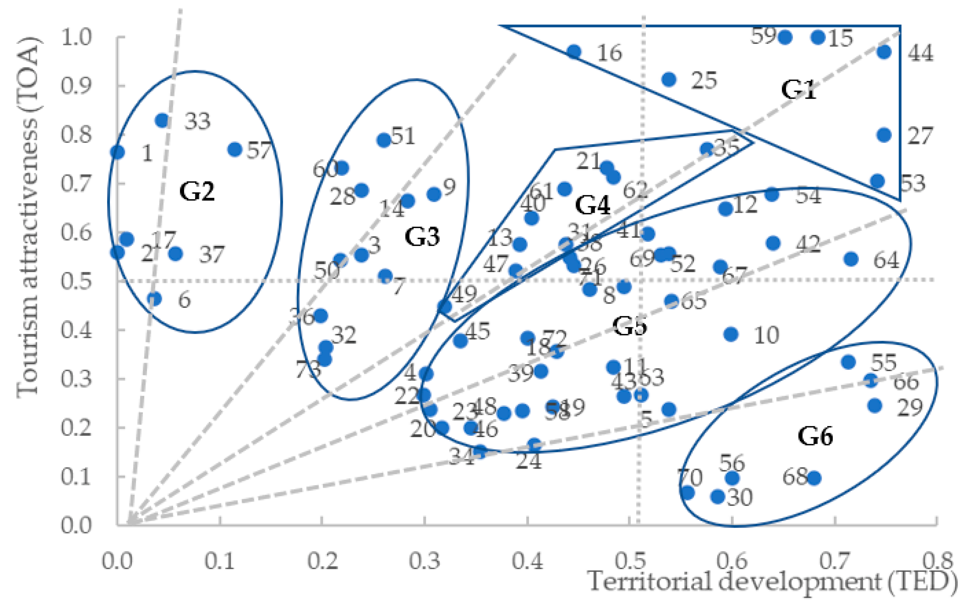
Figure 1 shows in a scatterplot the scores calculated for each municipality for the two aggregated indices of tourist attractiveness (
TOA) and territorial development (
TED). No association between the two measures can be observed at first glance. Therefore, the results of the analysis were interpreted by dividing the space in which the two indices assume positive values into four quadrants. It is worth noting how most municipalities obtain a score of tourism attractiveness higher than 0.5. Additionally, most municipalities obtain a score of territorial development lower than 0.5, and none obtains a score of territorial development higher than 0.8. Within the selected space, a group of municipalities (
G1) has the highest scores both in terms of tourist attractiveness and territorial development: Castelnuovo di Farfa, Cittaducale, Contigliano, Fara in Sabina, Montopoli di Sabina, Poggio Mirteto, and Rieti. Then, four groups of municipalities are identified according to their mix of territorial development and tourism attractiveness: relatively attractive but less developed municipalities (
G2); more attractive than developed municipalities (
G3); averagely attractive and developed municipalities (
G4); more developed than attractive municipalities (
G5), and well-developed but less attractive municipalities (
G6). The best-in-class for each group is for
G2 Leonessa (33), for
G3 Poggio Bustone (51), for
G4 Magliano Sabina (35), for
G5 Poggio Moiano (54) and Scandriglia (64), for
G6 Stimigliano (66). Excluding the top performers included in
G1, these municipalities seem to draw an efficiency frontier for all the other destinations; that is, given the selected proportion of territorial development and tourism attractiveness, they obtain the highest scores. Attractive municipalities are also Accumoli (1) and Posta (57) for
G2; Rivodutri (60), Fiamignano (28), Castel Sant’Angelo (14), and Cantalice (9) for
G3; Collevecchio (21), Roccantica (62) and Rocca Sinibalda (61) for
G4; Casperia (12) and Monteleone Sabino (42) for
G5; and Forano (29) and Poggio Nativo (55) for
G6.
In particular, the statistical evidence suggests that the municipalities of the Reatini Mountains inner area with tourism potential are, for the most part, poorly accessible and scarcely developed; consequently, these areas could be ideal destinations rather than for out-of-town trips or daily excursions, for second-home tourism or longer stays in agritourism, especially if one considers the municipalities of the Velino valley. This is a change of perspective that, although in some respects may limit the business opportunities related to daytrips and daily excursions, could instead contribute to local development in terms of real estate and infrastructural development and to greater interaction between tourists and the local community to the benefit of both. It is also true, however, that the naturalistic value of the landscapes could lead to perceiving remoteness and lack of territorial development as an element of attractiveness [
31], suggesting, for example, motorbiking trips in municipalities further away from the Metropolitan City of Rome, or short stays in remote localities in search for an escape from the congested urban life. Moreover, the statistical evidence highlights a group of municipalities (the one located in the lower right quadrant of the graph) that are rather developed and accessible but not very attractive from a tourist point of view. In these municipalities, the local administrations can promote the design and implementation of tangible and intangible leisure time infrastructures (cultural and naturalistic itineraries, theme parks, sports facilities, play areas, etc.) to increase the attractiveness of the places and exploit the easy accessibility to the Roman metropolitan area to intercept the share of demand for proximity tourism that is less interested in the local identity and more focused on the fruition of leisure services [
4,
32].
For the municipalities located in the lower left part of the graph (in fact, a minority), on the other hand, the planning of tourism-related local development paths cannot be considered a viable alternative. This quadrant includes several municipalities in the Reatini Mountains inner area, for which, therefore, rebus sic stantibus, tourism should not be considered a driver to trigger culturally sustainable rural development and overcome peripheralization [
33]. It is precisely in these municipalities that local administrations should concentrate their efforts on designing and implementing development strategies centered on the local community’s needs, excluding the mediating effect of tourism-related economic interests [
4]. In these municipalities, consistent public investments in welfare (health, education) and local public transport are the best and probably the only available alternative to peripheralization and social exclusion, as indicated in the Reatini Mountains Strategy Area [
23].
4. Discussion
As outlined in
Section 1, the aim of this research was to evaluate through a multidimensional analysis the tourism attractiveness of the municipalities located in the Province of Rieti, having in mind the needs of tourists and hikers living in the metropolitan area of Rome willing to plan an out-of-town trip or a daily excursion in the nature or in the countryside. The objective of the research is of interest in that it makes it possible to identify a model to counter depopulation and peripheralization of the rural and natural areas of the Latium Region located in the Province of Rieti, based on the development of sustainable local tourism value chains as enhancers of processes of rural and infrastructural development. Specifically, in several cases, the private interest of the urban residents in enjoying out-of-town trips in attractive rural and natural areas matches the right of peripheral residents to benefit from improved local welfare and of being involved in the local process of economic development, able to preserve the local identity while creating new jobs.
The result was achieved by developing a screening exercise involving two dimensions: territorial development and tourism attractiveness. For each dimension, an overall score was obtained by aggregating the elementary scores computed for a set of elementary indices. In general, the results of the evaluation indicate, for the province of Rieti as a whole, high local tourism potential and fair but unequal accessibility from the Metropolitan City of Rome, as well as a certain degree of territorial development, at least for the municipalities of lower Sabina. However, results suggest how the Province of Rieti may be structurally polarized along the dimension of proximity to local tourism (among the municipalities with both high territorial development and tourism potential, only Cittaducale is part of the inner area). Unless the tourism potential of the Reatini Mountains is re-evaluated, it is therefore difficult that the design of local development strategies centered on short stays, out-of-town trips, and daily excursions can autonomously contribute to narrowing the territorial and social imbalances at the provincial level. In fact, while the central part of the Province of Rieti may be an ideal territory for planning out-of-town trips and daily excursions, most municipalities located in the inner area of the Reatini Mountains are characterized by low accessibility and scarce territorial development. Consequently, in the inner area, especially in the Velino valley, a local development strategy based on proximity tourism may focus on longer stays, as those usually characterizing second-home tourism or short stays in agritourism farms [
4]. Furthermore, the naturalistic integrity of remote municipalities such as Accumoli, Amatrice, Borbona, Cittareale, Leonessa, Micigliano, and Posta may lead tourists to reinterpret the scarce accessibility and lack of territorial development (in most cases related to the earthquake of 2016) as an element of attractiveness, as it happens in the case of motorbiking trips or short stays in search for an escape from a congested urban life. In brief, rather than focusing only on center-periphery relations, the statistical evidence calls for a more in-depth analysis of the specificities of the municipalities of the Province of Rieti, the historical determinants of their development (or scarce development), the effects of the latter on multiple dimensions (culture, local institutions, local economy, environmental heritage, etc.), and the research of consumer niches that may be interested in the fruition of the local countryside capital [
26].
At methodological level, it is worth noting that the tourism attractiveness index does not consider the cultural and recreational value of the single elements considered, but rather the value of the mix of territorial elements (natural, cultural, concerning tourist accommodation and rural development) [
4]. Additionally, the scores of tourism attractiveness of Accumoli ad Amatrice are lower than expected because of the 2016 earthquake that destroyed the two historical towns [
34,
35]. Finally, the scores assigned to each municipality were computed on the data collected through desk research; consequently, the analysis could be complemented with field research and with a more in-depth analysis of the available references. As an example, the analysis of the institutional websites of each municipality (e.g., consider [
36,
37,
38,
39,
40]) allowed to considerably refine the research results by identifying natural and cultural amenities that were overlooked in more aggregated studies and online showcases. Consequently, it is reasonable to suspect that several municipalities that received a lower score in tourism attractiveness in this first assessment may reveal more attractive in practice (this may happen, as an example, for the municipalities of lower Sabina, which are those at the borders with the Province of Rome).
Finally, instead of contrasting depopulation and their distance from the poles of services in isolation, the municipalities of the inner areas may engage in spatial networks based on geographic and nongeographic proximity (cognitive, socioeconomic, organizational, etc.) [
41], as indicated in most annual monitoring reports of the National Strategy for Inner Areas [
6,
7]. In fact, the small municipalities in the Province of Rieti are characterized by a rather homogeneous mix of population, population density, local dwellers, foreign residents, and family relations that may facilitate the design of supra-local networks based on territorial proximity aiming at satisfying local communities’ needs and to trigger local development on a wider scale. Specifically, attention should be paid to the sustainable local development [
27] of cultural and territorial homogeneous areas along four dimensions: recognition and valorization of the local identity, attention paid to the needs of fragile and vulnerable social groups (local, foreign, or tourists), improved local welfare (education, health, etc.), and design and implementation of socioeconomic patterns of development privileging agricultural and deseasonalized tourism activities as means for engaging in more strategic sectors of economic activity, e.g., industrial districts of small and medium enterprises (
SMEs) [
23,
24].


