Article

Seismo-Stratigraphic Data of Wave-Cut Marine Terraces in the Licosa Promontory (Southern Tyrrhenian Sea, Italy)

1
Istituto di Scienze Marine (ISMAR), Consiglio Nazionale delle Ricerche (CNR), Sezione Secondaria di Napoli, 80133 Napoli, Italy
2
Istituto Nazionale di Geofisica e Vulcanologia (INGV), Osservatorio Vesuviano (OV), 80124, Napoli, Italy
*
Author to whom correspondence should be addressed.
Coasts 2024, 4(2), 392-418; https://doi.org/10.3390/coasts4020020
Submission received: 5 March 2024 / Revised: 12 May 2024 / Accepted: 23 May 2024 / Published: 28 May 2024

Abstract

:
Some seismo-stratigraphic evidence on the occurrence of wave-cut marine terraces in the Licosa promontory (Southern Tyrrhenian Sea, Italy) based on Sub-bottom Chirp seismic sections is herein presented. Such evidence is provided by marine terraced surfaces situated at various water depths below sea level and etched into the rocky acoustic basement, which are extensively extending in the seaward extension of the Licosa promontory. It is possible that the isotopic stratigraphy and the terraced marine surfaces are connected, so they can be attributed and dated indirectly. The geologic study of seismic profiles has pointed to the prominence of the acoustic basement, extending to the seabed close to the coast and subsiding seawards under the Quaternary marine succession. Ancient remains of marine terraces, found at a range of water depths between 5 m and 50 m, have documented the major morphological changes of the acoustic basement during the Late Quaternary.

1. Introduction

The aims of this paper are to introduce geomorphological data on the discovery of low-rank sea level highstand phases suggested by marine terraces off the shore of the Licosa promontory based on seismic study; to propose a correlation with the isotopic stratigraphy; and to discuss the relationships with the onshore marine terraces. The highstand system tract forms when the rapid relative sea level rise of the transgressive phase slows to a rate at which sediment accumulation is now equal to, or greater than, the accommodation rate. As a result, shoreline regression or stillstand occurs; the deposits that accumulate during this period of decreasing rise of the relative sea level constitute the highstand systems tract. High-resolution seismic data have been recorded onboard the R/V Urania (National Research Council of Italy, oceanographic cruise GMS03-02).
A marine terrace is a maritime landscape affected by wave action and currents. In a time period of tectonic uplift, a marine terrace forms at the time of the glacial–interglacial shift, when the contrast between the extents of sea level rise and tectonic uplift is negligible. Several terrace orders arise on a coastline as a result of varying sea levels, shown by marine terraces, which in the study area are located at water depths ranging between 5 and 50 m. A sequence of marine terraces of mixed orders with a causal relationship between the terrace chronology and its height is a clear sign of tectonic uplift in a coastal zone (Figure 1). If this is not the scenario, only terraces that developed throughout the interglacial ages that rise above the present average sea level will be seen, conserving them from coastal erosion and reworking processes.
A marine terrace is made up of an abrasion platform and a sea cliff (Figure 1). The abrasion platform is a slightly seaward-dipping layer whose slope is governed by grain size and sediment supply. The marine terrace is connected with the shoreline by the sea cliff, a sloping surface, whose height is regulated by lithology and by the erosion tendency of the geological successions (Figure 1). The three frames record a constant uplift, e.g., the crust tectonically going up. Sea level is independent of the tectonic uplift moving up and down, so the superposition of these two trends creates the terraces (Figure 1).
The tectonic patterns of the bedrock and the related seismo-stratigraphic framework, in lateral contact with extensive rocky outcrops, were the target of a careful geological study. The stratigraphic framework of the marine Quaternary sequence is well developed between the stream mouth of the Solofrone river and the port of Agropoli, while it is no longer present (or is poorly maintained) at the top of the Licosa promontory. The stratigraphic relations between the Quaternary succession and the acoustic basement, which arises from the sinking into the sea of the stratigraphic-structural units (“Flysch del Cilento” Auct.) built on land in the northern Cilento promontory, have been studied [1,2,3,4,5,6,7,8,9]. High-resolution seismic data fall on the Cilento continental shelf, between 10 m and 160 m of water depths (Figure 2).
The item of the tectonic uplift and the relationships with the onshore and offshore terraced landforms on the Eastern Tyrrhenian margin between the Cilento Promontory and Sapri have been deeply studied, including some several key papers [10,11,12,13,14,15,16,17,18,19,20,21,22,23,24,25]. Aiello [21] found evidence of marine terraces near the Cilento Promontory by studying a grid of Sub-bottom Chirp profiles and identifying the inner parts of the terraces as wavy-cut rocky terraces. However, a lot of detailed geological information on both the onshore and the offshore area is still needed. In this paper, an extensive literature review has been carried out on the onshore terraced landforms, since understanding them is critical for the geological interpretation of the marine terraces recognized offshore, based on our seismic dataset (Figure 2).
The Cilento Promontory has been affected by a tectonic uplift of about 400 m, Early-Middle Pleistocene in age. The tectonic uplift of the Cilento Promontory, as well as of the Southern Apennines, has been evaluated using the axial growth of Pleistocene marine terraces cropping out onshore [11,13,14,15,25,26,27]. In particular, the geomorphological study has evaluated the vertical offsets of the marine terraces based on both the height of the fault scarps and the rate of displacements affecting indicators of ancient base levels [11,13,14,15,25,26,27].
The geologic evolution of the Southern Apennines’ inner margin has been unraveled through the geomorphological survey of two areas, including a number of Plio-Quaternary landforms that stand by the Sorrento Peninsula and by Mt. Bulgheria [14]. In particular, the Mt. Bulgheria area southwards of the Cilento headland has been studied in detail, representing an excellent site of study of marine landforms in the Southern Apennines [12,14]. Here the youngest relict shorelines and deposits, recognized on the coastal cliffs of the promontory, have been correlated to the Marine Isotope Stage (MIS) 5e [28,29,30]. Above the most recent cliffs of Mt. Bulgheria, a group of uplifted marine terraces extends along the southern coastal belt from around 15 to 130 m a.s.l. They are made up of abrasion and wave-built patterns of landforms, related to the Middle Pleistocene [14].
Ferranti et al. [15] have put together a data collection of the Marine Isotope Substage (MIS) 5.5 highstand (125 ky) samples throughout the coastline of Italy, permitting a reconstruction of the axial deformation that affected the Central Mediterranean coastlines since the Late Pleistocene. Among others, the sites in Campania have been examined. The MIS 5.5 substage in Italy has been agreed upon by its existence. The ‘‘Tyrrhenian’’ of Issel [31] was firstly reported by Gignoux [32] as a chronostratigraphic subunit and was later formally designated as Eutyrrhenian by Bonifay and Mars [33]. The beach deposit cropping out at Cala Mosca in Sardinia was defined as the stratotype of this Eutyrrhenian subunit (“Couches a Strombe” of Gignoux) [32]. A warm fauna population known as ‘‘senegalaise fauna’’ [32], represented by mollusks (i.e., Strombus bubonius, Conus testudinarius, Cardyta calyculata senegalensis, Hyotissa hyotis) has colonized the Mediterranean shelves since MIS 5.5. The ‘‘senegalaise fauna’’ also includes the index fossil Strombus bubonius, entering the Mediterranean Sea from Gibraltar [34]. The types of markers on the MIS 5.5 highstand include the depositional markers (beach/lagoon deposits; backshore/foreshore deposits), the erosional markers (inner margin of marine terraces, marine terraces, tidal notches), and the biological markers (top of lithophaga hole-band, Dendropoma reef).
In particular, the inward edge of a marine terrace reflects the location of the paleo-shoreline. In cemented rocks, it is conveyed by a pathway that connects the wave-cut platform and the old coastal cliff. In porous lithologies, it is buried by colluvial deposits and cannot be easily discerned [15]. As a result, the marine terraces are usually weakening, and their inward edge is generally eroded. This is not true for the marine terraces examined in our study, whose inner margin is well-preserved, since they are carved in rocky lithologies. The maximum height of the marine terrace has been considered as a hint of paleo-sea level with an uncertainty of 20 m. This uncertainty is genetically related to the height and to the age estimate of the markers. Tidal notches are common intertidal features and give a good measurement of the mean sea level position with an uncertainty of 0.2 m. Figure 3 shows the detected markers of Campania [15].
The rocky areas of Campania and Tyrrhenian Basilicata have a marker called MIS 5.5. This marker is made up of notches and terraces in the water that are connected to radiometrically dated deposits. It is usually at the same level as the MIS 5.5 sea level marker. On the contrary, in the Volturno plain (Figure 3), the MIS 5.5 marker is found in a borehole at around −50 m [35], yielding an approximate subsidence rate of 0.45 mm/a. The Sarno plain, south of the Vesuvius volcano, has been subsiding at a lower rate over the last interglacial age. The MIS 5.5 marker was found at −29 m [36].
Several marine geological studies have been carried out in this area, but a systematic approach to the research item of the marine terraces has not yet been realized. Three orders of marine terraces, respectively located at water depths of 54 m, 86 m, and 107 m have been recognized offshore of the Licosa Cape [37,38,39]. They have a limited extension and are often found in correspondence with outcrops of acoustic basement. Trincardi and Field [38] have studied the geometry of the Late Pleistocene prograding coastal deposits of the Eastern Tyrrhenian margin, including the Cilento continental shelf.
Except for several recent studies on the submerged depositional terraces (SDT) [22,40,41], the submerged terraced landforms have been less investigated. Bilbao-Lasa et al. [22] analyzed the submerged depositional terraces of the Bay of Biscay (Spain). A staircase morphology of the shelf occurs, with 12 terraces distributed and preserved, whose depth ranges between 13 m and 92 m. The best time interval for the creation of the submerged marine terrace is between the Last Interglacial Maximum and the Last Glacial Maximum (LGM) [22].
While Savini et al. [23] discussed the terraced landforms occurring onshore and offshore of the Cilento headland by correlating evidence of emerged and submerged marine landforms, Tsanakas et al. [41] studied the Quaternary uplifted marine terraces of Kefalonia (Greece). Weigelt et al. [42] highlighted ridge-slope terraces in the Lomonosov Ridge (Arctic Ocean), where sediment drifts were deposited since the Early Miocene. Klöcking et al. [43] combined oceanic residual depth measurements, drainage pattern, stratigraphic setting, onshore marine terraces, and basement denudation to reconstruct the regional uplift of regional domes located in north-eastern Brazil and south-eastern Africa. Gao et al. [44] reconstructed the seismo-stratigraphic setting of the Central Mozambique Terrace, recognizing three regional unconformities and corresponding seismo-stratigraphic units. Off the shore of Norway, Hansen et al. [45] studied the Halten and Dønna terraces, including a set of rift-related sub- basins, Jurassic in age, filled with sediments in the Cretaceous. Off the shore of Portugal, Innocentini et al. [46] recognized wave-cut rocky terraces, whose depth range shows that they were formed by the MIS 5a–5d stillstand. In the eastern Siberian Sea, Ryabchuck et al. [47] showed submerged terraces formed during the Holocene, associated with longshore bars and foredeltas. Off the shore of New Zealand, Lichtfield et al. [48] discussed Holocene marine terraces carved in rocky substratum as recorders of earthquake uplift and constructed a model of tectonic uplift and terrace development. Finally, in the Gulf of Saros, Eris et al. [49] studied the stacking pattern of marine terraces, when the deepest marine terrace at 148 m formed during the Last Glacial Maximum. During the subsequent transgressive phase, transgressive and channel-fill seismo-stratigraphic units were deposited, intercalated with marine terraces, as controlled by local stillstands.

2. Geologic Setting

The Cilento Flysch includes the Formations of Pollica, S. Mauro, and Monte Sacro, showing an overall thickness of about 1500 m (Figure 4) [1,2,3,4,5,6,7,8]. While Vitale and Ciarcia [8] framed the Cilento Flysch in the tectono-stratigraphic setting of the Campania region, Mehmood et al. [9] analyzed some sedimentary features and inferred the current directions. In particular, the Ligurian Accretionary Complex includes the Nord-Calabrese Unit and the Parasicilide Unit [8]. In this interpretation, the Nord-Calabrese Unit is made up of three main formations, including the uppermost Cretaceous–Middle Eocene Crete Nere Formation, the Upper Eocene–lowermost Aquitanian Saraceno Formation and the lower Aquitanian–lower Burdigalian Sovereto Formation [8]. Moreover, these authors have established that the Cilento Group is composed of the Pollica and San Mauro Formations [8], which, in the southern sector of Campania, grade into the Albidona Formation [2]. Mehmood et al. [9] revised the stratigraphy of the Cilento Group, suggesting that the associations of the sedimentary facies of the Cilento Group showed palaeoenvironmental characteristics of submarine fan deposits, composed of turbidite sequences as controlled by sediment gravity flows. In the northern Cilento area the Cilento Group includes several depositional systems, mostly turbidite, which have been grouped in two formations, i.e., the Pollica and San Mauro Formations (Figure 4). The analysis of the turbidity palaeocurrents showed that some turbidity palaeocurrents have parallel and concordant directions, while others have opposite or orthogonal flow directions [9].
The coastal cliffs are carved in the sandstones and silts of the Pollica Formation (Figure 4). A geological investigation of the Quaternary sedimentary record spanning the towns of Agropoli and Ogliastro Marina has revealed the existence of five sea level paleo-stands at elevations ranging from 25 to 1.5 m a.s.l. The oldest levels, the Comenale Complex and the S. Antonio–S. Marco Complex has been tentatively ascribed to stages 9 and 7 of the isotopic stratigraphy. Abrasion terraces and notches, ascribed to stages 5e and 5c of the isotopic stratigraphy, have been reported at +8, +10, +4 m a.s.l.
The marine terraces cropping out onshore in the Southern Tyrrhenian coastal belt between the Cilento Promontory and Mt. Bulgheria have been studied by several authors [11,12,13,50,51,52,53,54,55,56,57,58,59,60]. In their basic geomorphologic study Cinque et al. [11] carried out a detailed geomorphological survey of Quaternary marine, transitional, and continental formations in the Trentova, Santa Maria, and San Marco bays, which are separated by the rocky promontories of the Tresino and Licosa Capes. The associated coastal landforms, including both depositional and wave-cut terraces, and notches have also been singled out. The marine terraces of the Santa Maria bay, uplifted up to 45 m a.s.l., are composed of the Comenale Complex, a thick transgressive–regressive succession, constituted by lagoon clays, fossiliferous marine sands, and aeolian sands. It is overlain by the S. Antonio transgressive complex, composed of a fossiliferous beach rock overlain by aeolian sands in its upper part. The marine terraces of the San Marco bay are characterized by two orders of wave-cut terraces located at 10 m and 4 m a.s.l., respectively. Four well-preserved orders of wave-cut terraces occur in the Licosa Cape (20–25 m; 8–10 m; 4 m; 1.5 m). Accordingly, to the interpretation of Cinque et al. [11], five ancient sea level stands occur in the Cilento Promontory, at heights ranging between 1.5 m and 50 m a.s.l..
Iannace et al. [13] studied the OIS (Oxygen Isotope Stage) 5c along the Licosa Cape promontory through geomorphology and U/Th dating. Four orders of wave-cut marine terraces occur based on the correlation with the S. Maria and Ogliastro bay terraces [11,13]. The highest order of terraces correlates to the end of the Middle Pleistocene (OIS 7), while the marine terraces located at lower heights ascribe to the main sea level highstands of the OIS 5 (OIS 5e, 5c, and 5a, respectively) [13]. The marine terraces are respectively located at elevations of 20–25 m, 6.5–10 m, 4 m, and 1.5 m a.s.l. [13].
Antonioli et al. [55] analyzed the geomorphologic setting of the emerged and submerged areas between Palinuro and Caprioli and recognized two lithostratigraphic units: the Lido Ficocelle unit, composing the present-day coastal cliff, and the overlying Eutyrrhenian unit, forming a wide beach rock. The deposits of this unit occur in small and isolated outcrops situated between Acciaroli and the Licosa Cape, and are more extensive in the coastal belt situated between Ogliastro Marina and Agropoli. The two lithostratigraphic units have been respectively referred to the MIS 7 and to the MIS 5. The attribution of these deposits to the MIS 5 has also been confirmed by 230Th/234U absolute dating.
There are analogous Quaternary deposits in the southern sector of Mt. Bulgheria [59] (Figure 5). Erosional markers of paleo-sea level stands occur along paleo-sea cliffs or in coastal cave systems, such as notches, wave-cut terraces, and the upper limits of Lithophaga burrows. Six groupings of Middle Pleistocene marine terraces lie between 75 and 15 m a.s.l., healthy along the western part of the Mt. Bulgheria coast. Three paleo-sea level stands are located between 10 and 3.5 m above sea level. The most recent one is made up of fossiliferous conglomerates and sands.
Marciano et al. [60] have contributed to the knowledge of the tephra layers interlayered in the Quaternary marine deposits in the Southern Cilento area, improving the tephrostratigraphic studies. The pyroclastic deposits, having a trachyte and phonolite composition, are interlayered within the Quaternary continental or marine sequences or overlie the wave-cut terraces, particularly abundant in the study areas. The stratigraphy of the Acqua di Cesare site has been described. The samples (SM1–4) have been collected in correspondence with a fluvial incision carving an old wave-cut terrace, which is located at about 10 m a.s.l., overlain by continental clastic deposits, including a pyroclastic layer. This layer includes a basal part, 15 cm thick, including coarse-grained pumiceous fragments (pumice, lapilli, and blocks) and an upper part with ash levels [60]. The CPL2 and CPL1 samples have been collected at the Licosa Cape, where a thick continental sequence crops out, including a tephra layer. The acoustic basement, composed of the Cilento Flysch, is characterized by a wave-cut terrace, which has been attributed to the substage 5c of the last interglacial [13]. In the southern Licosa promontory a wave-cut terrace, dated back to the Middle Pleistocene (OIS 7), occurs [11,13]. This terrace is overlain by alluvial deposits, consisting of poligenic conglomerates [60].
Figure 6 summarizes the type sections of Licosa, Ascea, and Palinuro based on the geological survey carried out by Marciano et al. [60], which has confirmed that the pyroclastic layers are younger than the MIS 5e substage (about 130 ky B.P.; Figure 6). The tephra PLV (Licosa section; Figure 6) is older than the end of the MIS 7 (200 ky B.P.) and the beginning of the MIS 5e (130 ky B.P.). The Cilento tephra have been correlated with the existing tephrostratigraphic data based on previous literature [61,62,63], based on both the volcanic glass chemistry and to the location of samples. The geochemical composition of the samples fits well with the chemical composition of the tephra of the S. Gregorio Magno lacustrine basin [63], correlated with the X-5 and X-6 tephra layers recognized by Wulf et al. [64]. The other Cilento tephra have been correlated with the Campanian Ignimbrite eruption and with the Y5 marine tephra, displaying a K20/Na2O ratio lower than 1.7. Other samples have been correlated with the Y-3 marine tephra, whose age has been established based on micropaleontological data on the marine core C45, collected in the Policastro Gulf and 14C datings as about 25.5 ka [65].
Marciano et al. [60] have outlined a morpho-stratigraphic and tephro-stratigraphic framework of the Cilento layers (Figure 6). The Punta Licosa sample (PLV in Figure 6) represents the older tephra layer recognized in the Cilento area, whose age ranges between the end of the MIS 7 and the beginning of the MIS 5e. This tephra could be genetically related to the eruptive activity of the Campania Volcanic Zone (CVZ) [66]. Otherwise, the SM1, SM2, and SA layers are genetically related to the X-6 tephrostratigraphic marker. The PL1, PL2, PL3, and AS tephra are genetically related to the Y-5 tephra, ascribed to the Campanian Ignimbrite [66]. Finally, the CPL1 and CPL2 tephra fit well with the geochemical composition of the Y-3 tephra, linked to the Phlegrean Fields [62,63,65].

3. Materials and Methods
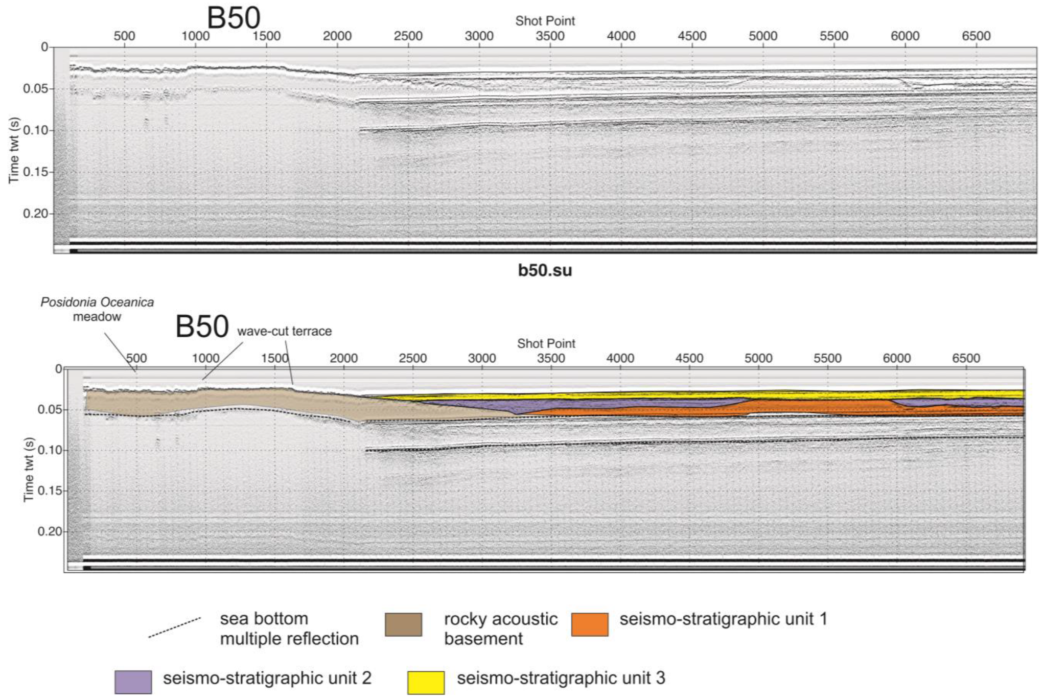
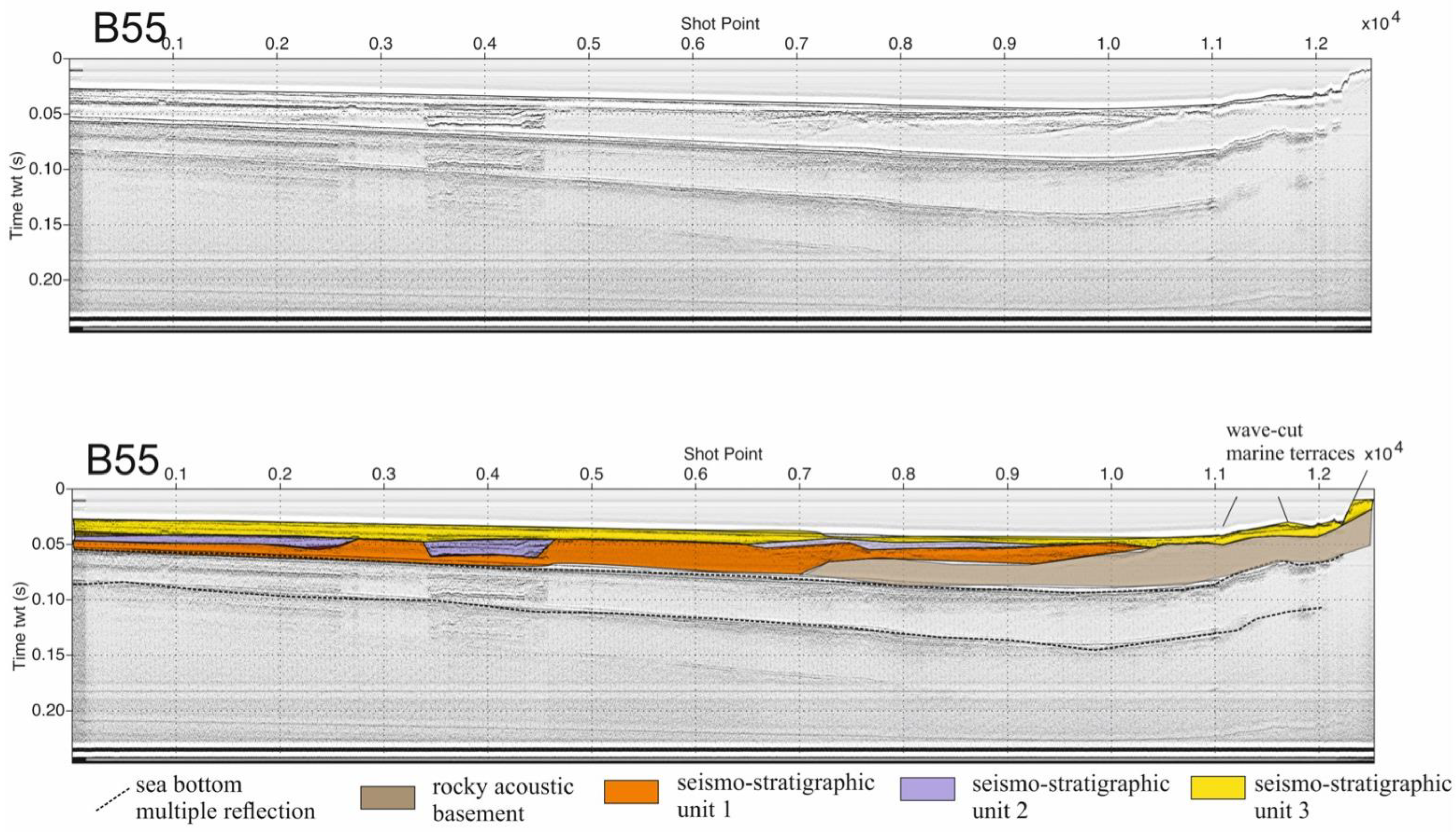
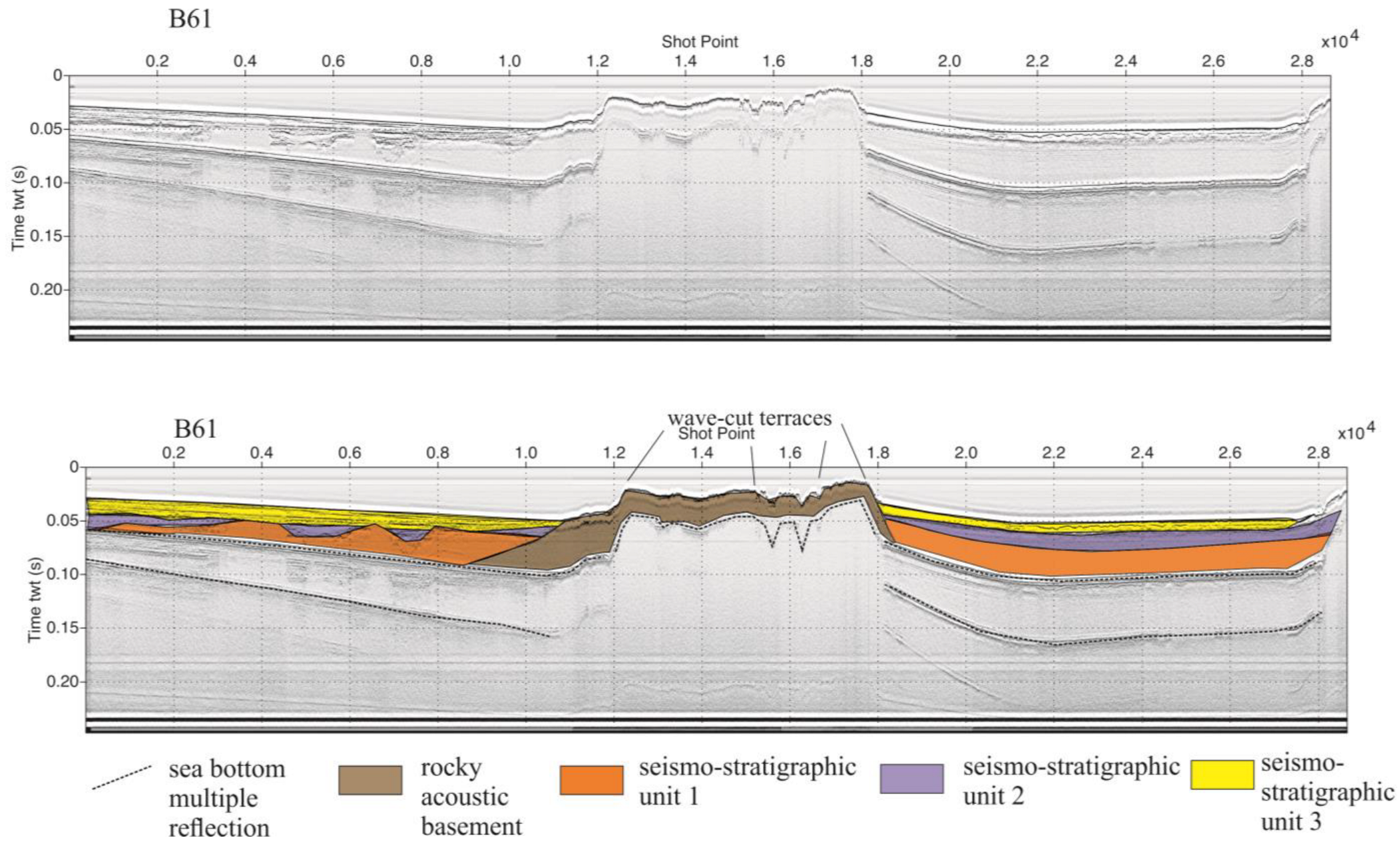
While the materials consist of high-resolution Sub-bottom Chirp seismic profiles, the methods include the review of the existing literature data on the coastlines outcropping onshore in the Cilento Promontory and the seismo-stratigraphic interpretation.
Seismic data acquisition was realized during the oceanographic cruise GMS03-01 (R/V Urania, National Research Council of Italy) in 2003, recording Sub-bottom Chirp, Sidescan Sonar, and magnetometric profiles. The Sub-bottom Chirp profiler (Datasonics Inc., Cataumet, United States.) has been used in seismic acquisition. A navigation map of the study seismic sections is shown in Figure 2.
The seismic processing was carried out using the Seismic Unix software, version SU44R28 (Available online: https://wiki.seismic-unix.org/start (accessed on 22 May 2024)). The seismic processing of the Sub-bottom Chirp seismic profiles consisted of several steps, including the conversion of the seismic traces from SEG Y (recorded onboard) to SU (Seismic Unix), the spectral analysis of the frequencies of the seismograms, and the application of fast Fourier transform (FFT) for the visualization and the analysis of the frequencies of the seismic signal. Moreover, the application of a high-pass filter with a low-cut frequency at 150 Hz was performed in order to eliminate the seismic noise and the dark signal. A uniform gain was applied on each seismic trace, while a time-variant gain (TVG) filter was applied in order to improve both the seismic signal of the deeper seismic reflectors and the whole visualization of all the seismic profiles. The final output of the processing sequence was the plotting of seismic profiles with Seismic Unix by using a graphic interface. A type section of the Sub-bottom Chirp processed data is shown in Figure 7.
The seismo-stratigraphic and sequence stratigraphic concepts [67,68] have been deeply revised by Catuneanu et al. [69] going towards a standardization of the sequence stratigraphy. The sequence stratigraphic framework is based on genetic units resulting from the interaction between the accommodation and the sedimentation, in particular the forced regressive unit, the lowstand and highstand normal regressive units, and the transgressive unit, bounded by sequence stratigraphic surfaces [69].
The reference curve of base level changes has been discussed [69]. At the onset of the forced regression, a correlative conformity is established. During the successive sea level fall, the regressive surface of erosion and the overlying subaerial unconformity are the corresponding stratigraphic surfaces. The forced regressive phase ends with a correlative conformity, which is covered by a maximum regressive surface at the end of the regression. During the transgressive phase, the stratigraphic-type surfaces are the transgressive ravinement surfaces and the maximum flooding surface, marking the end of the transgression. The onset of the next forced regressive phase is indicated by a correlative conformity [69].
This seismo-stratigraphic setting could be very useful if applied to the stratigraphic framework of the Cilento offshore, as shown by the geological interpretation of seismic profiles, focusing, in particular, on the identification of the wave-cut terraces carving the rocky acoustic basement genetically related to the Cilento Flysch and on the identification of significant stratigraphic surfaces and corresponding seismic units in the Quaternary marine deposits.

4. Results

4.1. Onshore Marine Terraces

A table has been constructed based on the available literature data on the onshore marine landforms and marine terraces (Table 1).
Based on the geological and geomorphological literature existing on the area, significant outcrops of marine terraces in the Cilento Promontory have been highlighted. Among them, we have considered the geomorphological study of Iannace et al. [13] (Figure 8). The highest order of marine terraces has been detected in the whole Cilento promontory, both in the northern and in the southern part. In the northern part of the promontory, this terrace is the only one preserved by coastal erosion. In particular, in the S. Marco area the terrace is overlain by the S. Marco—S. Maria sandstones, having a thickness of 5 m and interpreted as submerged coastal ridge deposits belonging to the MIS 7. The inner rim of terrace is located at 25 m a.s.l. and towards the sea it coincides with a coastal cliff dip, showing the occurrence of remnants of wave-cut terraces, located at 10 m a.s.l. In the southern part of the promontory this order of terraces has a wider extension and is carved in the deposits of the Pollica Formation (Cilento Flysch) [13].
The second order of marine terraces, ranging between elevations of 6.5 m and 10 m a.s.l. and detected in the southern part of the promontory, has shown well-preserved inner and outer rims [13]. It represents a wave-cut terrace, carving both the rocky acoustic basement and the conglomeratic deposits, overlying the highest order of terraces. In the whole area the second order of terraces is bounded by an active coastal cliff, showing the occurrence of two orders of paleo-sea level stands, respectively located at 4.5–5 m and 1.5 m. The first one, showing a good exposure, is characterized by erosional morphologies, including wave-cut terraces and paleocliffs, often overlain by marine deposits [13]. The height of the marine terraces refers to their inner rim, and the marine deposits are composed of biogenic calcilutites with red algae and echinids. Finally, the marine terrace occurring at 1.5 m is characterized by scattered outcrops, representing little remnants of wave-cut terraces.

4.2. Offshore Marine Terraces

The geological interpretation of the seismic sections has allowed a distinction to be made between the acoustic basement, outcropping in the coastal belt and having a wider extension with respect to that previously singled out [37,70,71] and the areas of sediment accumulation. This basement has been precisely mapped by Aiello and Caccavale [10] based on marine geological mapping performed in the frame of the CARG project.
The seismic profile B50 (Figure 9) has been detected at various depths that fluctuate between 18.75 m (starting acquisition) and 16.5 m (ending acquisition). The vertical penetration is of about 100 msec (about 62 m). The seismo-stratigraphic study has made possible the discovery of three main seismo-stratigraphic units, separated from erosional surfaces or paraconformities. The rocky acoustic basement (S unit) has been established, whose top is characterized by the occurrence of a wave-cut terrace, located at a water depth of about 17 m. Unit 1 is symbolized by parallel reflectors and appears to have a thickness of about 44 msec (corresponding to 37.5 m). It is divided at its top by a main seismic reflector, which is believed to have stratigraphic continuity.
Unit 2 is shaped by an acoustically transparent seismic facies and has an average thickness of about 10 msec (corresponding to 8.5 m); it is dominated by a lenticular geometry, completely closing in correspondence with a paleo-channel. Unit 2 represents a sandy body with a coarse-grained composition. Unit 3 is dominated by an acoustic facies with discontinuous reflectors having a high amplitude, alternating with more transparent intervals. It shows an average thickness of 20 msec (corresponding to about 17 m). This unit fills a wide palaeo-channel, interlayered in the inner part of the stratigraphic succession. The unit is probably composed of alternating sands (acoustically-transparent intervals) and shales (continuous reflectors).
The line B51 (Figure 10) is long, about 6.1 km, and has been traced with a NNE-SSW trending at water depths ranging between 19.5 m (starting acquisition) and 12 m (ending acquisition). The vertical penetration of the studied section is about 100 msec (about 64.5 m). A marine terrace has been observed, carving the nearshore outcrops of the rocky acoustic basement, whose rims are respectively located at water depths of 18 m and 21 m (Figure 10). The first unit, composed of marine sediments, is dominated by parallel reflectors and has an average thickness of 44 msec (about 37.5 m). The second unit is identified by an acoustically transparent seismic facies and by a wedge-shaped geometry. Its thickness is of about 10 msec (about 8.5 m). Unit 2 is composed of coarse-grained sands, forming the infilling of paleo-channels. Unit 3 is marked by discontinuous reflectors of high amplitude exhibiting an average thickness of about 20 msec (corresponding to about 17 m).
Two terraced surfaces, carving the top of the rocky acoustic basement, and the same seismo-stratigraphic units, as previously described, have been observed in the seismic profile B52 (Figure 11).
The rocky acoustic basement (S unit) is being eroded by remnants of terraced surfaces located at various water depths (8 m, 18 m, and 21 m on the seismic profile B55; 10 m and 17 m on the seismic profile B56), exhibiting the intricate morpho-evolution of the acoustic basement (Figure 12 and Figure 13).
The B61 line has been monitored between 21 m (starting acquisition) and 16 m (ending acquisition) with an NNE-SSW trend. The vertical penetration is of 69 msec, corresponding to about 59 m of sediments (Figure 14). The top of the acoustic basement appears to include several rims of terraced surfaces, respectively located at 24 m and 14 m (the first part of the section), and at 18 m, 10 m and 27 m (the second part of the section). A certain area of seabed with constant erosion has been discovered, as shown by the occurrence of erosional channels. The acoustic basement crops out in combination with a main morpho-structural high (Figure 14).
Wide outcrops of the acoustic basement are incised by three inner rims of marine terraces, severally, regained at water depths of 10 m, 20 m, and 50 m (Figure 15). Their top is often overlain by marine wedges, while other sectors are still eroded (Figure 16). Two paleo-channels, having an average extension of two km, have been observed. A similar seismo-stratigraphic framework has been observed.
Table 2 shows the data of Aiello [21] on the inner rims of the marine terraces offshore of the Cilento Promontory integrated with this paper.

5. Discussion and Conclusions

Low-relief surfaces resulting from the interaction between the tectonic uplift and eustatic sea level fluctuations are represented by marine terraces, which also serve as relevant geomorphological indicators of past sea level highstands.
In particular, the wave-cut terraces are morphological lineaments that form as a response to the coastal erosion in rocky lithologies, as happens in the case of the Cilento Flysch [1,2,3,4,5,6,7,8,9].
A wave-cut notch is created by erosional processes such as hydraulic action and abrasion, which results in a wave-cut terrace at the base of the coastal cliff. As a consequence of the widening of the notches, the coastal cliffs become unstable and collapse due to the gravitational processes.
The retreat of the coastal cliff towards the offshore area happens, and the coastal deposits deriving from the collapsed coastal cliff are transported away, leaving a wave-cut platform. This geological process is repeated over time.
A diagram has been constructed based on the geological interpretation of the seismic sections in order to show the trend of the marine terraces of the northern Cilento offshore area (Figure 16) [67,68,69]. This diagram has shown the complex morpho-evolution of wave-cut marine terraces carving the rocky acoustic basement in the northern Cilento offshore area.
The northern sector of the inner continental shelf, located between the Solofrone river mouth and the Licosa promontory, is dominated by a depressed area filled by marine deposits, as revealed by the marine sediments growing at the sea bottom, predominantly composed of grain-sized sand [10,72,73,74,75]. This area serves as the offshore extension of the S. Maria Plain, confined northwards by Mt. Tresino and southeastwards by the Castellabate hills. In this area, Quaternary deposits predominantly crop out (Areniti di S. Antonio; Areniti di S, Marco; Comenale Complex; Figure 17) [11].
In its southward region, the explored continental shelf effectively functions as a structural platform, ensuing from the seawards portion of the Licosa spur (Figure 4). This is demonstrated by the wide outcrops at the sea bottom of the rocky acoustic basement, genetically correlated with the Cilento Flysch [10,73,74,75]. Near shore the acoustic basement generally spreads, defining a terraced surface, plunging seawards with a low dip below the Quaternary deposits. Moving more seawards, this rocky basement will begin to crop out at the seabed in proximity to a morpho-structural high, broadening for about 1.4 km, as shown in Figure 15 and Figure 18. Here the top of the acoustic basement is marked by an erosional surface, probably polycyclic, affected by the inner rims of several terraced surfaces (Figure 16).
The geographical distribution of the Pleistocene marine terraces has yielded reliable rough estimates of the vertical uplift in the Cilento coastal belt. In the northern Cilento, the best-preserved marine terraces, dating back to the Middle Pleistocene, crop out at maximum heights of 60 m a.s.l. [11] (Table 1). At Mt. Bulgheria (southern Cilento) the Late Pliocene–Early Pleistocene marine terraces are uplifted at 450 m a.s.l. Here the marine terraces uplifted at 100 m a.s.l. are overlain by continental deposits including ancient manufacture, which hold the upper chronological limit of these terraces to the Early–Middle Pleistocene [76]. The shorelines genetically linked to the Eutyrrhenian paleo-sea level have been established at a similar height along all the Cilento coast, proposing that this region experienced a tectonic equilibrium at the end of the Middle Pleistocene [54].
In Mt. Bulgheria, the subsequent stages of uplift and tectonic deformation have created a number of orders of erosional structures with a low incline, sometimes sub-horizontal, disrupting the carbonate formation at elevations that vary between 400 and 1000 m. The shallowest and most recent of these paleo-base levels belong to the marine abrasion terraces, whose correlative deposits have been dated back to the Emilian substage of the Early Pleistocene [52,55]. Geologic study has revealed that the dislocation of the marine terraces occurred during the tectonic uplift of the district. Six orders of marine terraces, of heights ranging between 200 m and 50 a.s.l., which are younger than the Early Pleistocene terrace, have been established in the same place, but cannot be dated due to the paucity of datable materials [55]. Since the shallowest one is buried by continental deposits containing materials belonging to the central part of the Middle Pleistocene, the highest marine terraces can be dated back to the early stages of the Middle Pleistocene or to the closing stages of the Early Pleistocene [55].
Seven orders of marine terraces, placed at altitudes that vary between 180 m and 2 m a.s.l., appear at the Palinuro Cape [55]. These landforms erode both the Mesozoic carbonate rocks, constituting the bulk of the Palinuro Cape, and the Cenozoic siliciclastic deposits, outcropping northwards of the Palinuro Cape. The initial five sets of terraces, respectively located at 180/170 m, 140/130 m, 100 m, 75/65 m, and 50 m a.s.l., are wave-cut terraces, which only maintain on-site the vestiges of the original sedimentary cover. The sixth terrace, located at 8–7 m a.s.l., and the seventh terrace, located at 3–2 m a.s.l., are denoted by platforms and notches [55]. The observation of fragments of Strombus Bubonius in the marine deposits that belong to the youngest shoreline strongly supports its chronological reference to the Eutyrrhenian, previously proposed [55] based on amino acid racemization carried out on shells of Glycimeris glycimeris.
The geological setting of the marine erosional landforms attributed to the Eutyrrhenian and the sixth set of terraces identified by Antonioli et al. [55] has established their correlation with the highstand phase of the MIS 7. The five sets of the more ancient marine terraces are surrounded, from a chronological point of view, by the starting point of the Middle Pleistocene, based on their physical coherence with a similar set of shorelines, outcropping southwards, along the southern slope of Mt. Bulgheria, and dating back to the Middle Pleistocene [12].
Off the shore of the Palinuro Cape, the morphological indicator of paleo-stands of sea level is depicted by wave-cut terraces cropping out along the coastal cliff and by paleo-sea level notches. The wave-cut terraces have been assembled in four main orders, standing at water depths of 46–44 m, 24–18 m, 14–12 m, and 8–7 m [47] (Figure 18). The fossil shorelines located at water depths of 14–12 m and 8–7 m [55] are coeval to, or older than, the last interglacial phase. In fact, they show indicative signs of reworking in a subaerial situation, having occurred during a regressive phase, previous to the transgressive peak of the Late Pleistocene. The paleo-stand signified by the abrasion platforms and by the notches may be tentatively attributed to one of the minor sea level stands ascertained during substage 5.1 of the isotopic stage 5 (Figure 18).
The geomorphological data suggest that the terraced surfaces off the shore of the Licosa promontory can be correlated with the terraced surfaces identified off the shore of the Palinuro Cape [55].
A seismo-stratigraphic study of the Chirp lines has allowed us to discern four main sets of terraced surfaces (Figure 9, Figure 10, Figure 11, Figure 12, Figure 13, Figure 14, Figure 15 and Figure 16; Table 2). The old terraced surfaces have been detected at water depths which vary between 50 m and 43 m. This set of terraced surfaces could be in line with the marine terraces that appear at water depths between 46 and 44 m in the Palinuro Cape and appear chiefly in the central part of the morpho-structural high. The second set of terraced surfaces, in the northern Cilento offshore area, has been detected at water depths fluctuating between 27 m and 17 m and is consistent with the marine terraces discovered between 24 m and 18 in the Palinuro Cape. The third set of terraced surfaces has been seen at water depths in the range 14 m and 10 m and is comparable with the surfaces of 14 m and 12 m in the Palinuro Cape. The terrace rims located at 8 m are concurrent with, or older than, the last interglacial phase and are in agreement with the upper part of the isotopic stage 3. Based on seismo-stratigraphic evidence, the Eutyrrhenian coastline has not been detected.
A link between the extent of the terraced surfaces detected on a critical seismic line and the curve of isotopic stratigraphy of Martinson et al. [77] has been developed (Figure 19). As seen from the papers, the relative sea level increases were very rapid beginning from the Middle Pleistocene, if coupled with the subsequent relative sea level drops [77,78,79,80,81,82]. In combination with these sea level rises, ravinement surfaces were created, which are often embedded in the stratigraphic sedimentary records of Italy [83]. These layers took shape during time spans related, on the isotopic curve, to the phase shift from the even isotopic stages to the uneven ones. The isotopic curves have established that during the glacial Pleistocene the relative sea level increase was very abrupt and less similar in width to the most recent sea level rise (about 120 m), with a periodicity of 100 ky [84].
Referring to the pattern of correlation (Figure 19), the portions of terraced surfaces that appear at water depths that vary between 50 and 43 (represented on the seismic section in the lower part of the figure) would likely correspond to a relatively short stillstand during the post-glacial transgression. This transgression was very rapid and did not yield any significant delay, long enough to expose erosional traces on rocky formations. Geomorphological research off the Palinuro Cape has pointed out that this transgression has gradually made possible the weathering and removal of the detritus slope fan that was over the base of the coastal cliffs during the last glacial phase, permitting for the rejuvenation of older coastal features [55].
A second set of terraced surfaces has been uncovered at depths that stretch between 27 m and 17 m. A third set of terraced surfaces has been determined between 11 m and 8 m and is closely associated with the ending tract of the isotopic stage 3 (Figure 19). This hypothesis is substantiated by the correlation of the height of these surfaces with the height reported in the curve of relative sea level fluctuations by Alessio et al. [23] and similar depths detected offshore the Palinuro Cape [55].
A fourth set of terraced surfaces has been highlighted at 8 m (Figure 19). These terrace rims could be genetically related to one of the minor peaks of isotopic stage 5 and could be correlated with the abrasion notches recognized at 7 m along the coastal cliff of Palinuro Cape, assigned to isotopic stage 5.1 (Figure 18) [55].
The obtained results fit well with those collected for marine terraces located in other significant sectors of the Mediterranean area [41,45,46,49]. Tsakanas et al. [41] highlighted uplifted marine terraces at Kephalonia (Greece) and compared their dating to the sea level fluctuations on the eustatic curve, suggesting that the +32 m terrace age of 61 ± 5.5 ka is genetically related to the MIS3e sub-stage. Since the sequence of uplifted marine terraces in the landscape is thought to be the geomorphic record for Quaternary sea level highstands, we can connect each terrace to a Marine Isotope Stage [41]. Hansen et al. [45] applied valuable tectono-stratigraphic models to the Halten and Donna terraces, off the shore of Norway, displaying the control of rift systems and fault development on the terrace morphology, which is tectonically controlled. In the southern shelf of the Madeira Archipelago, Innocentini et al. [46] mapped two groups of submerged erosional terraces, respectively located at water depths of 35–45 m and 50–75 m, and proved their correlation with the Marine Isotope Stages (MIS) 5a–5d stillstands or with older relative sea level stillstands. In the Gulf of Saros (Mediterranean Sea), Eris et al. [49] studied and correlated a set of submerged terraces based on seismo-stratigraphic and core data. The LGM time frame in the gulf is closely linked to the lowstand sea level, creating the deepest marine terrace at −148 m. The increase in sea level in response to post-glacial cooling was supported by the accumulation of transgressive deposits. This transgressive condition was affected by three relatively short stillstand levels at 17, 14.6, and 13.6 ky B.P., to give rise to the younger marine terraces in the gulf, at water depths ranging between −90 m and −135 m.
In conclusion, this work represents the starting point and the data collection for in-depth and specific investigations for the evaluation of the alterations and safety of the coastal cliff areas of northern Cilento affected by retreat phenomena.

Author Contributions

Conceptualization, G.A.; methodology, G.A.; software, M.C.; formal analysis, G.A.; writing—original draft preparation, G.A.; writing—review and editing, G.A and M.C. All authors have read and agreed to the published version of the manuscript.

Funding

This research received no external funding.

Data Availability Statement

No new data were created or analyzed in this study. Data sharing is not applicable to this article.

Conflicts of Interest

The authors declare no conflicts of interest.

References

  1. Amore, F.O.; Bonardi, G.; Ciampo, G.; De Capoa, P.; Perrone, V.; Sgrosso, I. Relazioni tra “flysch interni” e domini appenninici: Reinterpretazione delle Formazioni di Pollica, San Mauro e Albidona nel quadro dell’evoluzione infra-miocenica delle zone esterne appenniniche. Mem. Soc. Geol. Ital. 1988, 41, 285–297. [Google Scholar]
  2. Bonardi, G.; Amore, F.O.; Ciampo, G.; De Capoa, P.; Miconnet, P.; Perrone, V. Il Complesso Liguride Auct.: Stato delle conoscenze e problemi aperti sulla sua evoluzione appenninica e i suoi rapporti con l’Arco calabro. Mem. Soc. Geol. Ital. 1988, 41, 17–35. [Google Scholar]
  3. Cammarosano, A.; Cavuoto, G.; Danna, M.; De Capoa, P.; De Rienzo, F.; Giardino, S.; Martelli, L.; Nardi, G.; Sgrosso, A.; Toccaceli, R.M.; et al. Nuovi dati sui Flysch del Cilento (Appennino meridionale Italia). Boll. Soc. Geol. Ital. 2004, 123, 253–273. [Google Scholar]
  4. Cammarosano, A.; Cavuoto, G.; Martelli, L.; Nardi, G.; Toccaceli, R.M. Il Progetto CARG nell’area silentina (area interna Appennino meridionale): Il nuovo assetto stratigrafico-strutturale derivato dal rilevamento dei fogli 503, 502 e 519 (Vallo della Lucania, Agropoli e Capo Palinuro). Rend. Soc. Geol. Ital. 2011, 12, 19–22. [Google Scholar]
  5. Critelli, S.; Muto, F.; Tripodi, V.; Perri, F. Relationships between lithospheric flexure, thrust tectonics and stratigraphic sequences in foreland setting: The Southern Apennines foreland basin system, Italy. In New Frontiers in Tectonic Research at the Midst of Plate Convergence, 1st ed.; Intech Open Access Publisher: Rijeka, Croatia, 2011; pp. 121–170. [Google Scholar] [CrossRef]
  6. Patacca, E.; Scandone, P. Il contributo degli studi stratigrafici di superficie e sottosuolo alla conoscenza dell’Appennino Campano-Lucano. In Proceedings of the Conference “Ricerca, Sviluppo ed Utilizzo delle Fonti Fossili: Il Ruolo del Geologo”, Potenza, Italy, 30 November–2 December 2012; pp. 97–153. [Google Scholar]
  7. Martelli, L.; Nardi, G.; Cammarosano, A.; Cavuoto, G.; Aiello, G.; D’Argenio, B.; Marsella, E.; Ferraro, L. Note Illustrative Della Carta Geologica d’Italia Alla Scala 1:50,000; Regione Campania, ISPRA (Servizio Geologico d’Italia): Rome, Italy, 2016; pp. 1–110. Available online: http://www.isprambiente.gov.it/Media/carg/noteillustrative/502_Agropoli.pdf (accessed on 28 October 2023).
  8. Vitale, S.; Ciarcia, S. Tectono-stratigraphic setting of the Campania region (southern Italy). J. Maps 2018, 14, 9–21. [Google Scholar] [CrossRef]
  9. Mehmood, M.; Ciarcia, S.; Lo Schiavo, L.; Natale, J.; Vitale, S. Paleogeographic and Tectonic Evolution of the Earliest Wedge-Top Basin in the Southern Apennines: New Insights from the Paleocurrent Analysis of the Cilento Group Deposits (Southern Italy). Geosciences 2023, 13, 238. [Google Scholar] [CrossRef]
  10. Aiello, G.; Caccavale, M. The Depositional Environments in the Cilento Offshore (Southern Tyrrhenian Sea, Italy) Based on Marine Geological Data. J. Mar. Sci. Eng. 2021, 9, 1083. [Google Scholar]
  11. Cinque, A.; Romano, P.; Rosskopf, C.; Santangelo, N.; Santo, A. Morfologie costiere e depositi quaternari tra Agropoli ed Ogliastro Marina (Cilento–Italia meridionale). Quaternario 1994, 1, 3–16. [Google Scholar]
  12. Ascione, A.; Romano, P. Vertical movements on the eastern margin of the Tyrrhenian extensional basin. New data from Mt. Bulgheria (Southern Apennines, Italy). Tectonophysics 1999, 315, 337–356. [Google Scholar] [CrossRef]
  13. Iannace, A.; Romano, P.; Santangelo, N.; Santo, A.; Tuccimei, P. The OIS 5c along Licosa Cape promontory (Campania region, southern Italy): Morphostratigraphy and U/Th dating. Z. Geomorphol. 2001, 45, 307–319. [Google Scholar] [CrossRef]
  14. Caiazzo, C.; Ascione, A.; Cinque, A. Late Tertiary–Quaternary tectonics of the Southern Apennines (Italy): New evidences from the Tyrrhenian slope. Tectonophysics 2006, 421, 23–51. [Google Scholar] [CrossRef]
  15. Ferranti, L.; Antonioli, F.; Mauz, B.; Amorosi, A.; Dai Pra, G.; Mastronuzzi, G.; Monaco, C.; Orrù, P.; Pappalardo, M.; Radtkei, U.; et al. Markers of the last interglacial sea-level high stand along the coast of Italy: Tectonic implications. Quat. Int. 2006, 145–146, 30–54. [Google Scholar] [CrossRef]
  16. Valente, A. Studi Sedimentologici Sulla Successione Miocenica di Monte Sacro (Flysch del Cilento). Tesi di Dottorato di Ricerca in Geologia del Sedimentario. Ph.D. Thesis, Università degli Studi di Napoli “Federico II”, Dipartimento di Scienze della Terra, Naples, Italy, 1993; 170p. [Google Scholar]
  17. Savini, A.; Basso, D.; Bracchi, V.A.; Corselli, C.; Pennetta, M. Maerl-bed mapping and carbonate quantification on submerged terraces offshore the Cilento peninsula (Tyrrhenian Sea, Italy). Geodiversitas 2012, 34, 77–98. [Google Scholar] [CrossRef]
  18. Budetta, P. Landslide Hazard Assessment of the Cilento Rocky Coasts (Southern Italy). Int. J. Geol. 2013, 1, 1–8. [Google Scholar]
  19. Pennetta, M.; Bifulco, A.; Savini, A. Ricerca di depositi di sabbia sottomarina relitta sulla piattaforma continentale del Cilento (SA) utilizzabile per interventi di ripascimento artificiale dei litorali. Geol. Ambiente 2013, 2013 (Suppl. S1), 1–21. [Google Scholar]
  20. Aiello, G.; Marsella, E. Geological Evolution of Coastal and Marine Environments off the Campania Continental Shelf Through Marine Geological Mapping—The Example of the Cilento Promontory. In Applied Studies of Coastal and Marine Environments, 1st ed.; Marghany, M., Ed.; Intech Science Publishers: Rijeka, Croatia, 2016; pp. 13–53. [Google Scholar] [CrossRef]
  21. Aiello, G. Elaborazione ed interpretazione geologica di sismica di altissima risoluzione nell’offshore del promontorio del Cilento (Tirreno meridionale, Italia). Quad. Geofis. 2019, 155, 1–24. [Google Scholar]
  22. Bilbao-Lasa, P.; Jara-Muñoz, J.; Pedoja, K.; Álvarez, I.; Aranburu, A.; Iriarte, E.; Galparsoro, I. Submerged Marine Terraces Identification and an Approach for Numerical Modeling the Sequence Formation in the Bay of Biscay (Northeastern Iberian Peninsula). Front. Earth Sci. 2020, 8, 47. [Google Scholar] [CrossRef]
  23. Alessio, M.; Allegri, L.; Antonioli, F.; Belluomini, G.; Improta, S.; Manfra, M.; Preite-Martinez, M. La curva di risalita del mare Tirreno negli ultimi 43 ka ricavata da datazioni su speleotemi sommersi e dati archeologici. Mem. Descr. Carta Geol. D’Ital. 1994, 52, 261–276. [Google Scholar]
  24. D’Angelo, S.; Di Stefano, F.; Lettieri, M.T.; Russo, G.F.; Violante, C. The map of the marine landscapes and habitats of Cilento, Vallo di Diano and Alburni Geopark. Linking geo- and bio-diversity with a multiscalar approach. In Proceedings of the 12th European Geoparks Conference, National Park of Cilento, Vallo di Diano and Alburni Geopark, Italy, 4–6 September 2013. [Google Scholar]
  25. Cerrone, C.; Di Donato, V.; Mazzoli, S.; Robustelli, G.; Soligo, M.; Tuccimei, P.; Ascione, A. Development and deformation of marine terraces: Constraints to the evolution of the Campania Plain Quaternary coastal basin (Italy). Geomorphology 2021, 385, 107725. [Google Scholar] [CrossRef]
  26. Santangelo, N.; Romano, P.; Ascione, A.; Russo Ermolli, E. Quaternary evolution of the Southern Apennines coastal plains: A review. Geol. Carpath. 2017, 68, 43–56. [Google Scholar] [CrossRef]
  27. Santangelo, N.; Di Donato, V.; Lebreton, V.; Romano, P.; Russo Ermolli, E. Palaeolandscapes of Southern Apennines during the late Early and the Middle Pleistocene. Quat. Int. 2012, 267, 20–29. [Google Scholar] [CrossRef]
  28. Shackleton, N.J.; Sánchez-Goñi, M.F.; Pailler, D.; Lancelot, Y. Marine Isotope Substage 5e and the Eemian Interglacial. Glob. Planet Change 2003, 36, 151–155. [Google Scholar] [CrossRef]
  29. Lisiecki, L.E. Ages of MIS Boundaries. LR04 Benthic Stack; Boston University: Boston, MA, USA, 2005. [Google Scholar]
  30. Medley, S.; Elizabeth, P. High Resolution Climate Variability from Marine Isotope Stage 5: A Multi-Proxy Record from the Cariaco Basin, Venezuela; University of California: Los Angeles, CA, USA, 2011. [Google Scholar]
  31. Issel, A. Lembi fossiliferi quaternari e recenti nella Sardegna meridionale. Accad. Naz. Lincei 1914, 23, 759–770. [Google Scholar]
  32. Gignoux, M. Les formations marines pliocenes et quaternaires de l’Italie du sud et de la Sicilie. Ann. L’Univ. Lyon 1913, 36, 693. [Google Scholar]
  33. Bonifay, F.; Mars, P. Le Tyrrhenien dans le cadre de la chronologie quaternaire mediterraneenne. Bull. Soc. Geol. Fr. 1959, 7, 62–78. [Google Scholar] [CrossRef]
  34. Dai Pra, G.; Magri, G.; Spada, A. Evoluzione morfologica di Strombus bubonius Lamarck di Ravagnese (Reggio Calabria). Geol. Appl. Idrogeol. 1974, 53–93. [Google Scholar]
  35. Romano, P.; Santo, A.; Voltaggio, M. L’evoluzione geomorfologica della pianura del fiume Volturno (Campania) durante il tardo Quaternario (Pleistocene medio-superiore–Olocene). Quaternario 1994, 7, 41–56. [Google Scholar]
  36. Barra, D.; Cinque, A.; Gedwelt, M.; Hurtgen, C. L’ospite caldo Sylvestra seminis (Bonaduce, Masoli & Pugliese, 1976) (Crustacea, Ostracoda): Un possibile marker dell’ultimo interglaciale dell’area mediterranea. Quaternario 1991, 4, 327–332. [Google Scholar]
  37. Ferraro, L.; Pescatore, T.S.; Russo, B.; Senatore, M.R.; Vecchione, C.; Coppa, M.G.; Di Tuoro, A. Studi di geologia marina sul margine tirrenico: La piattaforma continentale tra Punta Licosa e Capo Palinuro (Tirreno meridionale). Boll. Soc. Geol. Ital. 1997, 116, 473–485. [Google Scholar]
  38. Trincardi, F.; Field, M.E. Collapse and flow of lowstand shelf-margin deposits: An example from the Eastern Tyrrhenian, Italy. Mar. Geol. 1991, 105, 77–94. [Google Scholar] [CrossRef]
  39. Gasperini, L.; Stanghellini, G. SeisPrho: An interactive computer program for processing and interpretation of high resolution reflection profiles. Comput. Geosci. 2009, 35, 1497–1507. [Google Scholar] [CrossRef]
  40. Budillon, F.; Amodio, S.; Contestabile, P.; Alberico, I.; Innangi, S.; Molisso, F. The present-day nearshore submarine depositional terraces off the Campania coast (South-eastern Tyrrhenian Sea): An analysis of their morpho-bathymetric variability. In Proceedings of IMEKO TC-19 International Workshop on Metrology for the Sea, Naples, Italy, 5–7 October 2020. [Google Scholar]
  41. Tsanakas, K.; Saitis, G.; Evelpidou, N.; Karymbalis, E.; Karkani, A. Late Pleistocene Geomorphic Evolution of Cephalonia Island, Western Greece, Inferred from Uplifted Marine Terraces. Quaternary 2022, 5, 35. [Google Scholar] [CrossRef]
  42. Weigelt, E.; Jokat, W.; Eisermann, H. Deposition history and paleo-current activity on the southeastern Lomonosov Ridge and its Eurasian flank based on seismic data. Geochem. Geophys. Geosyst. 2020, 21, e2020GC009133. [Google Scholar] [CrossRef]
  43. Klöcking, M.; Hoggard, M.J.; Rodríguez Tribaldos, V.; Richards, F.D.; Guimarães, A.R.; Maclennan, J.; White, N.J. A tale of two domes: Neogene to recent volcanism and dynamic uplift of northeast Brazil and southwest Africa. Earth Planet. Sci. Lett. 2020, 547, 116464. [Google Scholar] [CrossRef]
  44. Gao, Y.; Stow, D.; Tang, Y.; Xie, X.; Piper, D.J.W. Seismic stratigraphy and deep-water sedimentary evolution of the southern Mozambique margin: Central Terrace and Mozambique Fracture Zone. Mar. Geol. 2020, 427, 106187. [Google Scholar] [CrossRef]
  45. Hansen, L.; Hodgson, D.M.; Pontén, A.; Thrana, C.; Obradors Latre, A. Mixed axial and transverse deep-water systems: The Cretaceous post-rift Lysing Formation, offshore Norway. Basin Res. 2021, 33, 2229–2251. [Google Scholar] [CrossRef]
  46. Innocentini, S.; Quartau, R.; Casalbore, D.; Roque, C.; Vinhas, A.; Santos, R.; Rodrigues, A. Morpho-stratigraphic characterization of the southern shelf of Porto Santo Island (Madeira Archipelago): Insights for small-scale instability processes and post-LGM sedimentary architecture. Mar. Geol. 2022, 444, 106729. [Google Scholar] [CrossRef]
  47. Ryabchuk, D.V.; Sergeev, A.Y.; Budanov, L.M.; Zhamoida, V.A.; Nosevich, E.S.; Grigoriev, A.G.; Neevin, I.A.; Bashirova, L.D.; Ponomarenko, E.V.; Pushina, Z.V.; et al. New Data on the Geological Development of the Southern Part of the East Siberian Sea in the Late Pleistocene–Holocene. Oceanology 2022, 62, 903–918. [Google Scholar] [CrossRef]
  48. Litchfield, N.; Morgenstern, R.; Clark, K.; Howell, A.; Grant, G.; Turnbull, J. (2023) Holocene marine terraces as recorders of earthquake uplift: Insights from a rocky coast in southern Hawke’s Bay, New Zealand. Earth Surf. Process. Landf. 2023, 48, 452–474. [Google Scholar] [CrossRef]
  49. Eriş, K.K.; Yakupoğlu, C.; Biltekin, D.; Yakupoğlu, N.; Sabuncu, A.; Polonia, A.; Gasperini, L. Late Pleistocene-Holocene sea level and climate changes in the Gulf of Saros: Evidence from seismostratigraphic record and sediment core data. Quat. Int. 2024, in press. [Google Scholar] [CrossRef]
  50. Blanc, A.C.; Segre, A.G. Les formations Quaternaires et le gisements paléolithiques de la cote de Salerno. In Excursions dans les Abruzzes, les Pouilles et Sur la Cote de Salerne, Proceedings of the Actes du IV Congres Internationale du Quaternaire, Roma and Pisa, Italy, August–September 1956; Stanford Library: Stanford, CA, USA, 1956. [Google Scholar]
  51. Baggioni-Lippmann, M. Nèotectonique et géomorphologie dans l’Apennin Campanien (Italie méridionale). Rev. Geol. Dyn. Geogr. Phys. 1981, 23, 41–54. [Google Scholar]
  52. Borrelli, A.; Ciampo, G.; De Falco, M.; Guida, D.; Guida, M. La morfogenesi del Monte Bulgheria (Campania) durante il Pleistocene inferiore e medio. Mem. Soc. Geol. Ital. 1988, 41, 667–672. [Google Scholar]
  53. Brancaccio, L.; Cinque, A.; Russo, F.; Belluomini, G.; Branca, M.; Delitala, L. Segnalazione e datazione di depositi marini tirreniani sulla costa campana. Boll. Soc. Geol. Ital. 1990, 109, 259–265. [Google Scholar]
  54. Romano, P. La distribuzione dei depositi marini pleistocenici lungo le coste della Campania. Stato delle conoscenze e prospettive di ricerca. Studi Geol. Camerti 1992, 1, 265–269. [Google Scholar]
  55. Antonioli, F.; Cinque, A.; Ferranti, L.; Romano, P. Emerged and submerged quaternary marine terraces of Palinuro Cape (southern Italy). Mem. Descr. Carta Geol. D’Ital. 1994, 52, 237–260. [Google Scholar]
  56. Russo, F. Segnalazione di un livello fossilifero riferibile al Tirreniano a Cala Bianca (Marina di Camerota). Mem. Descr. Carta Geol. D’Ital. 1994, 52, 237–260. [Google Scholar]
  57. Brancaccio, L.; Cinque, A.; Romano, P.; Rosskopf, C.; Russo, F.; Santangelo, N. L’evoluzione delle pianure costiere della Campania: Geomorfologia e neotettonica. Mem. Soc. Geogr. Ital. 1995, 53, 313–336. [Google Scholar]
  58. Romano, P. L’attività di ricerca geoarcheologica di Aldo Cinque. Mediterranee 2009. [Google Scholar] [CrossRef]
  59. Esposito, C.; Filocamo, F.; Marciano, R.; Romano, P.; Santangelo, N.; Scarciglia, F.; Tuccimei, P. Late Quaternary shorelines in Southern Cilento (Mt. Bulgheria): Morphostratigraphy and chronology. Quaternario 2003, 16, 3–14. [Google Scholar]
  60. Marciano, R.; Munno, R.; Petrosino, P.; Santangelo, N.; Santo, A.; Villa, I. Late Quaternary tephra layers along the Cilento coastline. J. Volcanol. Geotherm. Res. 2008, 177, 227–243. [Google Scholar] [CrossRef]
  61. Paterne, M.; Guichard, F.; Labeyrie, J.; Gillot, P.Y.; Duplessy, J.C. Tyrrhenian sea tephrochronology of the oxygen isotope record for the past 60,000 years. Mar. Geol. 1986, 72, 259–285. [Google Scholar] [CrossRef]
  62. Munno, R.; Petrosino, P. New constraints on the occurrence of Y-3 Upper Pleistocene tephra marker in the Tyrrhenian Sea. Quaternario 2004, 17, 11–20. [Google Scholar]
  63. Munno, R.; Petrosino, P. Tephra layers in the S. Gregorio Magno lacustrine succession. J. Quat. Sci. 2007, 22, 247–266. [Google Scholar] [CrossRef]
  64. Wulf, S.; Brauer, A.; Mingram, J.; Zolitschka, B.; Negendank, J.F.W. Distal tephra in the sediments of the Monticchio maar lakes. In La Geologia del Monte Vulture; Principe, C., Ed.; Consiglio Nazionale delle Ricerche: Rome, Italy, 2006; pp. 115–122. [Google Scholar]
  65. Buccheri, G.; Bertoldo, M.; Coppa, M.G.; Munno, R.; Pennetta, M.; Siani, G.; Valente, A.; Vecchione, C. Studio multidisciplinare della successione sedimentaria tardo-quaternaria proveniente dalla scarpata continentale del Golfo di Policastro (Tirreno meridionale). Boll. Soc. Geol. Ital. 2002, 121, 187–210. [Google Scholar]
  66. Rolandi, G.; Bellucci, F.; Heizler, M.T.; Belkin, H.E.; De Vivo, B. Tectonic controls on the genesis of ignimbrites from the Campanian Volcanic Zone, southern Italy. Miner. Pet. 2003, 79, 3–31. [Google Scholar] [CrossRef]
  67. Vail, P.R.; Mitchum, R.M.; Thompson, S. Seismic stratigraphy and global changes of sea level, part IV: Global cycles of relative changes of sea level. In Seismic Stratigraphy—Applications to Hydrocarbon Exploration; Memoir 26; Payton, C.E., Ed.; American Association of Petroleum Geologists: Tulsa, OK, USA, 1977; pp. 83–98. [Google Scholar]
  68. Mitchum, R.M.; Vail, P.R.; Thompson, S. Seismic stratigraphy and global changes of sea-level, part 2: The depositional sequence as a basic unit for stratigraphic analysis. In Seismic Stratigraphy—Applications to Hydrocarbon Exploration; Memoir, 26; Payton, C.E., Ed.; American Association of Petroleum Geologists: Tulsa, OK, USA, 1977; pp. 53–62. [Google Scholar]
  69. Catuneanu, O.; Abreu, V.; Bhattacharya, J.P.; Blum, M.D.; Dalrymple, R.W.; Eriksson, P.G.; Fielding, C.R.; Fisher, W.L.; Galloway, W.E.; Gibling, M.R.; et al. Towards the Standardization of Sequence Stratigraphy. Pap. Earth Atmos. Sci. 2009, 92, 1–33. [Google Scholar] [CrossRef]
  70. Gambassini, P.; Ronchitelli, A. Linee di sviluppo dei complessi del Paleolitico inferiore-medio nel Cilento. Riv. Sci. Preist. 1998, 49, 357–377, ISSN 0035-6514. [Google Scholar]
  71. Coppa, M.G.; Russo, B.; Siani, G. The Holocene foraminiferal assemblages of the continental margin between Agropoli and Capo Palinuro (Tyrrhenian sea, Italy). Boll. Soc. Paleontol. Ital. 1988, 2, 67–91. [Google Scholar]
  72. Available online: https://wiki.seismic-unix.org/start (accessed on 22 May 2024).
  73. Guida, D.; Valente, A. Terrestrial and Marine Landforms along the Cilento Coastland (Southern Italy): A Framework for Landslide Hazard Assessment and Environmental Conservation. Water 2019, 11, 2618. [Google Scholar] [CrossRef]
  74. Aiello, G.; Caccavale, M. New Seismoacoustic Data on Shallow Gas in Holocene Marine Shelf Sediments, Offshore from the Cilento Promontory (Southern Tyrrhenian Sea, Italy). J. Mar. Sci. Eng. 2022, 10, 1992. [Google Scholar] [CrossRef]
  75. Aiello, G.; Caccavale, M. A Seismo-Stratigraphic Analysis of the Relict Deposits of the Cilento Continental Shelf (Southern Italy). Proceedings 2023, 87, 10. [Google Scholar] [CrossRef]
  76. Palma di Cesnola, A. Il Paleolitico inferiore in Campania. In Proceedings of the Atti della XXIII Riunione Istituto Italiano Preistoria Protostoria, Firenze, Italy, 7–9 May 1980. [Google Scholar]
  77. Martinson, D.G.; Pisias, N.G.; Hays, J.D.; Imbrie, J.; Moore, T.C.; Shackleton, N.J. Age dating and the orbital theory of the ice ages: Development of a high-resolution 0 to 300.000 year chronostratigraphy. Quat. Res. 1987, 27, 1–29. [Google Scholar] [CrossRef]
  78. Shackleton, N.J.; Opdyke, N.D. Oxygen isotope and paleomagnetic stratigraphy of equatorial pacific core V28-238: Oxygen isotope temperature and ice volume on a 10 year scale. Quat. Res. 1973, 3, 39–55. [Google Scholar] [CrossRef]
  79. Chappell, J.; Shackleton, N.J. Oxygen isotopes and sea level. Nature 1986, 324, 137–140. [Google Scholar] [CrossRef]
  80. Bard, E.; Hamelin, B.; Fairbanks, R.G. U-Th ages obtained by mass spectrometry in corals from Barbados: Sea level during the past 130.000 years. Nature 1990, 346, 456–458. [Google Scholar] [CrossRef]
  81. Bard, E.; Labeyrie, L.D.; Pichon, J.J.; Labracherie, M.; Arnold, J.; Duprat, J.; Moyes, J.; Duplessy, Y. The last deglaciation in the southern and northern hemispheres: A comparison based on oxygen isotopes, sea surface temperatures estimates and accelerator C14 dating from deep sea sediments. In Geological History of the Polar Oceans: Arctic vs. Antartic; Bleil, U., Thiede, J., Eds.; Kluwer Academic: Boston, MA, USA, 1990; pp. 405–416. [Google Scholar]
  82. Pirazzoli, P.A. Global sea level changes and their measurement. Glob. Planet. Change Lett. 1973, 8, 135–148. [Google Scholar] [CrossRef]
  83. Aiello, G.; Budillon, F. Lowstand prograding wedges as fourth-order glacio-eustatic cycles in the Pleistocene continental shelf of Apulia (southern Italy). In Cyclostratigraphy. Approaches and Case Histories; D’Argenio, B., Fischer, A.G., Premoli Silva, I., Weissert, H., Ferreri, V., Eds.; SEPM: Tulsa, OK, USA, 2004; pp. 215–230. [Google Scholar]
  84. Bonifay, E. L’Ere Quaternarie: Définition, limites and subdivision sur la base de la chronologie Méditerraneé. Bull. Soc. Géol. Fr. 1975, 17, 380–393. [Google Scholar] [CrossRef]
Figure 1. Diagram showing the geological evolution of marine terraces during a tectonic uplift of the landscape in relation to the sea level fluctuation. Inset (A): a marine terrace is carved during a relative sea level highstand. Inset (B): the sea level drops and the marine terrace is uplifted. Inset (C): during the next relative sea level highstand a new marine terrace is cut into the landscape below the older terrace. This scheme explains the formation of different sets of marine terraces. Red color indicates the tract of sea level in the eustatic curve Modified after https://serc.carleton.edu/download/images/30773/marine_terrace_formation.jpg (accessed on 24 March 2024).
Coasts 04 00020 g001
Figure 2. Location map of the Sub-bottom Chirp profiles of the Cilento offshore (modified after Aiello and Caccavale) [10]. Colors black lines indicate seismic profiles and dotted lines indicate roadmap.
Coasts 04 00020 g002
Figure 3. Elevation of the MIS 5.5 markers, indicated by numbers in black in meters with respect to the modern sea level, plotted on a Digital Elevation Model (DEM) of Campania and Tyrrhenian Basilicata (modified after Ferranti et al. [15]). Red line indicates the location of the geological section reported in the upper part of the figure, while dotted lines indicates the thrust front of the Apenninic chain.
Coasts 04 00020 g003
Figure 4. Geological map of the northern sector of the Cilento Promontory (left side of figure). Stratigraphic column of the outcropping formations (right side of the figure) Key. Undifferentiated Quaternary deposits; San Mauro and Pollica Formations, Liguride and Sicilide units, Piaggine, Bifurto and Cerchiara Formations); modified after Vitale and Ciarcia [8].
Coasts 04 00020 g004
Figure 5. Erosional morphologies in the southern sector of Mt. Bulgheria (Courtesy of Dr. Pancaldi https://maupanphoto.com/index.php/archivio/appenninomeridionale/monti-del-cilento (accessed on 22 May 2024).
Coasts 04 00020 g005
Figure 6. Stratigraphic correlations between the type sections of Cilento, Ascea, and Palinuro (modified after Marciano et al. [60]. Key. 1: Acoustic basement, genetically related to the Cilento Flysch; 2: Wave-cut terrace; 3: Last interglacial marine and eolic sands; 4: Alluvial conglomerates; 5: Paleosols; 6: Tephra layers; 7: Slope breccias; 8: Colluvial deposits; 9: Present-day soils.
Coasts 04 00020 g006
Figure 7. Type section of the processed seismic data in the Cilento offshore.
Coasts 04 00020 g007
Figure 8. Geomorphological maps off the Cilento Promontory (top of figure; modified after Iannace et al. [13]). Geological section of the marine terraces of Mt. Bulgheria (bottom of figure; modified after Ascione and Romano [12]).
Coasts 04 00020 g008
Figure 9. Seismic profile B50 and corresponding geological interpretation.
Coasts 04 00020 g009
Figure 10. Seismic profile B51 and corresponding geological interpretation.
Coasts 04 00020 g010
Figure 11. Seismic profile B52 and corresponding geological interpretation.
Coasts 04 00020 g011
Figure 12. Seismic profile B55 and corresponding geological interpretation.
Coasts 04 00020 g012
Figure 13. Seismic profile B56 and corresponding geological interpretation.
Coasts 04 00020 g013
Figure 14. Seismic profile B61 and corresponding geological interpretation.
Coasts 04 00020 g014
Figure 15. Seismic profile B62_A and corresponding geological interpretation.
Coasts 04 00020 g015
Figure 16. Integrated diagram showing the complex morpho-evolution of wave-cut marine terraces in the northern Cilento offshore area.
Coasts 04 00020 g016
Figure 17. Geological sections (AA′, BB′, CC′) of the Quaternary continental deposits of the S. Maria Plain (modified after Cinque et al. [11]).
Coasts 04 00020 g017
Figure 18. Diagram summarizing the geomorphologic evidence of palaeo-sea level stands onshore and offshore the Palinuro Cape (modified after Antonioli et al. [55]).
Coasts 04 00020 g018
Figure 19. Correlation of the inner rims of marine terraces of the northern Cilento offshore area with the curves of isotopic stratigraphy (after Martinson et al. [77]).
Coasts 04 00020 g019
Table 1. The onshore terraced landforms and marine terraces based on the literature data.
Geological UnitLocationMarine Terraces and Terraced LandformsHeight (a.s.l.)References
Cilento Flysch siliciclastic unitnorthern Cilento PromontoryMiddle Pleistocene (MIS 9)60 mCinque et al. [11]
Cilento Flysch siliciclastic unitnorthern Cilento PromontoryMiddle Pleistocene (MIS 7) 25 mCinque et al. [11]; Marciano et al. [60]
Cilento Flysch
siliciclastic unit
northern Cilento PromontoryUpper Pleistocene (MIS 5e)6.5 m–10 mBrancaccio et al. [53]; Cinque et al. [11]; Marciano et al. [60]
Cilento Flysch
siliciclastic unit
northern Cilento PromontoryUpper Pleistocene (MIS 5c)4 m–5 mCinque et al. [11]; Iannace et al. [13]; Marciano et al. [60]
Cilento Flysch
siliciclastic unit
northern Cilento PromontoryUpper Pleistocene (MIS 5a)1.5 mCinque et al. [11]; Iannace et al. [13]; Marciano et al. [60]
Cilento GroupCilento PromontoryUpper Pleistocene (MIS 5e)6 mBlanc and Segre [50]; Brancaccio et al. [53]; Brancaccio et al. [57]
Mt. Bulgheria
carbonatic unit
Palinuro Cape
(southern Cilento Promontory)
Lower Pleistocene350 mRomano [54];
Antonioli et al. [55]; Borrelli et al. [52]
Mt. Bulgheria
carbonatic unit
Palinuro CapeMiddle Pleistocene170 m–180 mAntonioli et al. [55]
Mt. Bulgheria
carbonatic unit
Palinuro CapeMiddle Pleistocene130 m–140 mAntonioli et al. [55]
Mt. Bulgheria
carbonatic unit
Palinuro CapeMiddle Pleistocene65 m–75 mAntonioli et al. [55]
Mt. Bulgheria
carbonatic unit
Palinuro CapeMiddle Pleistocene50 mAntonioli et al. [55]
Mt. Bulgheria
carbonatic unit
Palinuro CapeUpper Pleistocene7 m–8 mAntonioli et al. [55]
Mt. Bulgheria
carbonatic unit
Palinuro CapeUpper Pleistocene2 m–3 mAntonioli et al. [55]
Mt. Bulgheria
carbonatic unit
Mingardo riverMiddle Pleistocene15 m–75 mEsposito et al. [59]
Mt. Bulgheria
carbonatic unit
Mingardo riverUpper Pleistocene10 m–12 mEsposito et al. [59]
Mt. Bulgheria
carbonatic unit
Mingardo riverUpper Pleistocene3 m–4 mEsposito et al. [59]
Mt. Bulgheria carbonatic unitMarina di CamerotaLower Pleistocene0 m–350 mRomano [54];
Antonioli et al. [55]; Cinque et al. [11]; Borrelli et al. [52]
Mt. Bulgheria
carbonatic unit
Marina di CamerotaMiddle Pleistocene50 m–200 mGambassini and Ronchitelli [70]
Mt. Bulgheria
carbonatic unit
Marina di CamerotaUpper Pleistocene15 mAntonioli et al. [55]; Esposito et al. [59]
Mt. Bulgheria
carbonatic unit
Marina di CamerotaUpper Pleistocene10 m–12 mBaggioni-Lippmann [51];
Antonioli et al. [55]; Esposito et al. [59]
Mt. Bulgheria
carbonatic unit
Marina di CamerotaUpper Pleistocene (MIS 5)8 m–8.5 mRusso [56];
Antonioli et al. [55];
Esposito et al. [59]
Mt. Bulgheria
carbonatic unit
Marina di CamerotaUpper Pleistocene (MIS 5)5 m–7.5 mRusso [56];
Antonioli et al. [55];
Esposito et al. [59]
Mt. Bulgheria
carbonatic unit
Marina di CamerotaUpper Pleistocene (MIS 5)4 m–4.5 mRusso [56];
Antonioli et al. [55];
Esposito et al. [59]
Mt. Bulgheria
carbonatic unit
Marina di CamerotaUpper Pleistocene (MIS 5)3 m–3.5 mRusso [56];
Antonioli et al. [55];
Esposito et al. [59]
Table 2. The number of terraced surfaces and the depth of the terrace rims related to corresponding seismic profiles (modified after Aiello [21]).
Seismic ProfileNumber of Terraced Surfaces (Inner Rim of Marine Terrace)Water Depths of the Inner Rims of Marine Terraces
B50, B50_1117 m
B51218 m, 21 m
B52218 m, 21 m
B5538 m, 18 m, 21 m
B56210 m, 17 m
B61a214 m, 24 m
B61b310 m, 18 m, 27 m
B62310 m, 20 m, 50 m
B1535 m, 19 m, 31 m
B19344 m, 47 m, 50 m
B20310 m, 21 m, 43 m
B22315 m, 25 m, 47 m
Disclaimer/Publisher’s Note: The statements, opinions and data contained in all publications are solely those of the individual author(s) and contributor(s) and not of MDPI and/or the editor(s). MDPI and/or the editor(s) disclaim responsibility for any injury to people or property resulting from any ideas, methods, instructions or products referred to in the content.

