Proceeding Paper

Preserving Tradition, Protecting the Environment: The Potential of Water Cadastre Systems to Mitigate the Effects of Batik Production on Groundwater and Subsidence in Pekalongan †

Department of Geodesy and Geomatics Engineering, Faculty of Earth Science and Technology, Institut Teknologi Bandung, Bandung 40132, West Java, Indonesia
*
Author to whom correspondence should be addressed.
Presented at the 6th International Conference on Green Environmental Engineering and Technology (IConGEET2024), Bali, Indonesia, 29–30 August.
Environ. Earth Sci. Proc. 2025, 33(1), 8; https://doi.org/10.3390/eesp2025033008
Published: 27 March 2025

Abstract

:
Batik, a traditional Indonesian textile art, significantly contributes to Pekalongan’s economy but has severe environmental impacts. The production process depletes groundwater and causes land subsidence. This study evaluates the potential of a water cadastre system to address these issues while preserving cultural heritage. By analysing batik production data, groundwater extraction, and subsidence trends via satellite imagery and field surveys, the research reveals a marked decline in groundwater levels and increased subsidence. The findings underscore the need for integrated water management to protect Pekalongan’s environment and cultural legacy, with a water cadastre system offering a possible solution.

1. Introduction

Batik, a traditional textile art from Indonesia, holds considerable cultural and economic significance. Its historical importance in Pekalongan was further affirmed when UNESCO recognised it as a cultural heritage in 2009, underscoring batik’s value as an intangible cultural asset of Indonesia [1,2]. Economically, the batik industry is a crucial source of income for many Pekalongan families. The shift from traditional hand-drawn techniques to modern production methods has enhanced the scalability and accessibility of batik products [3]. The Ministry of Industry of Indonesia reported that batik exports reached approximately USD 52.44 million in 2020, reflecting its importance as an export commodity. Additionally, the industry supports over 15,000 artisans in Pekalongan, highlighting its role in job creation. A study on the socio-cultural effects of batik production in Pekalongan found that it strengthens community bonds and fosters cultural pride. It also plays a significant role in advancing gender equality by providing economic opportunities for women, who constitute the majority of the workforce in this sector.
Although batik production brings social and economic benefits, it has raised environmental concerns, especially regarding water quality. The dyeing process involves various chemicals, which results in the release of untreated wastewater into surface water bodies, thereby degrading water quality. The batik industry in Pekalongan generates a substantial amount of wastewater, with estimates indicating that approximately 5 million litres of waste are produced daily [4]. This wastewater often contains high levels of Chemical Oxygen Demand (COD) and Biochemical Oxygen Demand (BOD), which are indicators of organic pollution. For instance, studies have shown that the COD levels in rivers affected by batik waste can exceed acceptable thresholds, with recorded values significantly higher than the maximum limit of 50 mg/L [5]. The presence of heavy metals, such as lead, has also been detected in well water samples from areas surrounding batik production centres, further indicating the extent of pollution [6].
It also impacts the ecological stability of Pekalongan’s water resource which has been compromised due to the influx of untreated batik wastewater. The intrusion of synthetic dyes and other chemicals into water bodies disrupts aquatic ecosystems, leading to the death of marine life and a decline in biodiversity [7,8]. Moreover, the pollution has affected agricultural practices, as contaminated water is often used for irrigation, resulting in crops that may appear healthy but have poor yield due to the toxic effects of pollutants [7]. The health implications of water pollution in Pekalongan are concerning. Direct contact with polluted water can cause skin irritations and other health issues among local residents [5]. Additionally, the consumption of contaminated water poses significant health risks, particularly for communities relying on dug wells for their water supply [6]. The cumulative effect of these health risks underscores the urgent need for effective wastewater management and pollution control measures. All these conditions impact the huge amount of groundwater extraction.
Groundwater serves as a crucial resource for approximately 54.76% of Pekalongan’s population [9]. However, the overextraction of groundwater, exacerbated by the pollution of surface water, has led to declining groundwater levels and quality. The contamination of surface water can infiltrate groundwater supplies, introducing pollutants such as heavy metals and organic compounds into aquifers [10]. Studies have shown that dug wells in areas surrounding batik production centres often contain heavy metals above acceptable limits, indicating that surface water pollution is directly affecting groundwater quality [6].
The relationship between surface water and groundwater in Pekalongan is characterised by a hydrological cycle where surface water bodies recharge groundwater aquifers. However, the pollution of surface water disrupts this natural process, leading to a decline in groundwater quality and availability [9]. Additionally, the increasing demand for groundwater due to the pollution of surface water has resulted in unsustainable extraction practices, further aggravating the situation [4,9].
The extensive extraction of groundwater in response to surface water pollution has led to a critical environmental issue: land subsidence. Land subsidence, the gradual sinking of the ground, has been observed in various parts of Pekalongan, causing infrastructural damage and increasing vulnerability to flooding. The batik dyeing process involves the use of various chemicals, which often end up as untreated wastewater discharged into surface water bodies. This practice has resulted in severe surface water pollution in Pekalongan, deteriorating the quality of rivers and other water sources. As surface water quality declines, the dependence on groundwater for industrial and domestic use intensifies, leading to extensive groundwater extraction. This overextraction of groundwater has been identified as a major cause of land subsidence, a phenomenon where the ground sinks due to the removal of subsurface materials. Land subsidence in Pekalongan has led to significant infrastructural damage, increased flood risks, and adverse socio-economic consequences for local communities.
The interplay between batik production, groundwater exploitation, and land subsidence presents a multifaceted problem. The economic benefits derived from batik are overshadowed by the environmental degradation and social issues arising from water pollution and land subsidence. This situation necessitates a balanced approach that addresses both the conservation of cultural heritage and the protection of environmental resources. Pressing issues include ensuring sustainable water use, mitigating pollution, and preventing further land subsidence while maintaining the socio-economic benefits of batik production.
This study develops a sustainable, integrated land and water management strategy that, on the one hand, addresses the causal relationships between water use, land subsidence, and resource sustainability while ensuring the preservation of batik as a cultural practice. It employs a water cadastre framework to design a mitigation strategy that balances groundwater management with the preservation of Pekalongan’s cultural heritage.

2. Materials and Methods

The research on the effects of batik production on groundwater depletion and land subsidence in Pekalongan City incorporated various essential datasets. First, information on the geographical distribution of batik production sites, workshops, and small-scale artisanal operations within the city was gathered from local government records, industry organisations, satellite images, and fieldwork. Second, the study examined the relationship between groundwater exploitation and land subsidence, utilising data on groundwater extraction rates, well depths, and documented subsidence incidents, sourced from geological and hydrological studies. Additionally, land subsidence data were analysed using spatial interpolation methods such as kriging or inverse distance weighting (IDW) to generate continuous maps showing subsidence patterns across the city. These data were drawn from Global Navigation Satellite System (GNSS) measurements, Interferometric Synthetic Aperture Radar (InSAR) data, and geodetic surveys. Coastal inundation due to subsidence was also mapped using topographic maps and land elevation data, obtained from coastal field surveys and models.

Methods

This research adopted a multi-dimensional methodological approach to thoroughly examine the effects of batik production on groundwater depletion and land subsidence in Pekalongan City. The initial phase involved mapping the locations of batik production facilities throughout the city, drawing on local government records, industry associations, satellite imagery, and field surveys to pinpoint areas at risk of environmental impact. To determine the link between groundwater extraction and land subsidence, correlation analysis was conducted using data on groundwater extraction rates and documented subsidence events from water table assessments. Next, land subsidence data were interpolated using spatial techniques such as kriging or inverse distance weighting (IDW), producing detailed maps that depict subsidence patterns across the city. Finally, coastal inundation risks was mapped by combining the interpolated subsidence data with topographic maps and land elevation data, gathered from coastal surveys and models. This holistic approach offered valuable insights into the environmental and socio-economic effects of batik production, helping to inform effective policy and conservation measures.

3. Results and Discussion

Pekalongan is a coastal city located on the northern coast of Central Java. Pekalongan lies at approximately 6°52′ S latitude and 109°40′ E longitude, facing the Java Sea. The city is about 96.40 kilometres west of Semarang, the capital of Central Java. As of recent estimates, Pekalongan has a population of around 317.524 in 2023. The city’s economy is strongly tied to the batik industry, which employs a large portion of the population. Small and medium enterprises dominate the market. Pekalongan’s batik industry began to flourish during the Dutch colonial period in the late 19th century. The introduction of industrial techniques and the establishment of batik factories allowed for mass production while maintaining the artistry of traditional batik. The city’s strategic location as a port enabled it to become a melting pot of various cultural influences, including Javanese, Chinese, and Arab traditions, which are reflected in the motifs and techniques used in Pekalongan batik [11,12].
The 1970s and 1980s marked a period of rapid growth, as the demand for batik surged both domestically and internationally. The distinctive colours and patterns of Pekalongan batik began to gain recognition, leading to increased export opportunities [13,14]. The establishment of various batik companies and cooperatives during this time played a crucial role in promoting Pekalongan batik to a broader audience [15,16]. From the list of small and medium batik industries (IKM) in Pekalongan Regency, there are 1824 batik companies distributed across various villages, including Medono, Podosugih, Tirto, Pringrejo, Sapuro Kebulen, Bendan Kergon, Pasirkratonkramat, Kauman, Poncol, Klego, Gamer, Noyontaansari, Setono, Kali Boros, Jenggot, Banyurip, Buaran Kradenan, Kuripan Kertoharjo, Kuripan Yosorejo, Sokoduwet, Bandengan, Kandangpanjang, Panjang Wetan, Degayu, Krapyak, and Padukuhan Kraton as can be seen on Figure 1.

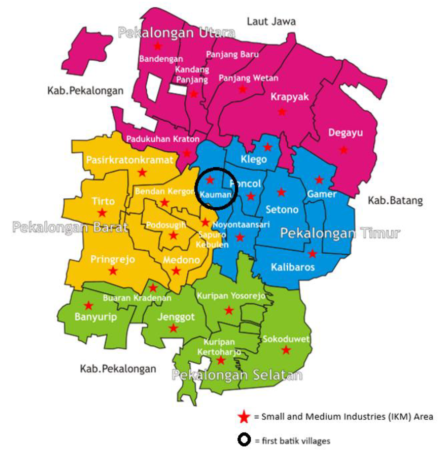
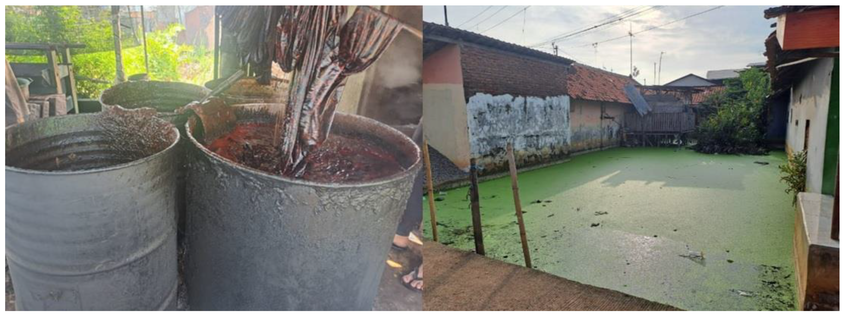
3.1. Batik’s Direct Contribution to Surface Water Pollution and Groundwater Exploitation

Batik production processes have been recognised as major contributors to both surface water contamination and groundwater extraction. The process is highly water-intensive, requiring large quantities of water for dyeing, washing, and rinsing fabrics. The previous study mapped the water required for the natural dye batik-making process by large-scale SMEs using the footprint approach, which was found to be 1309–5549 L/pc. Meanwhile, in a small-scaled SME, the water required to process batik is 550.72 L/pc [17]. Due to limited surface water availability, batik producers in Pekalongan depend heavily on groundwater [18]. This reliance is further aggravated by the declining quality of surface water, which pushes producers to extract even more groundwater. Additionally, the disposal of batik wastewater, which has a considerable water footprint, directly contributes to water pollution, as illustrated in Figure 2.
Analysis of water table changes due to groundwater exploitation in Pekalongan over the past 20 years, from 1980 to 2020, reveals a notable decrease in water levels, particularly between 2005 and 2015. During this period, groundwater levels fell by an average of 4 m per year in the affected regions, as illustrated in Figure 3.

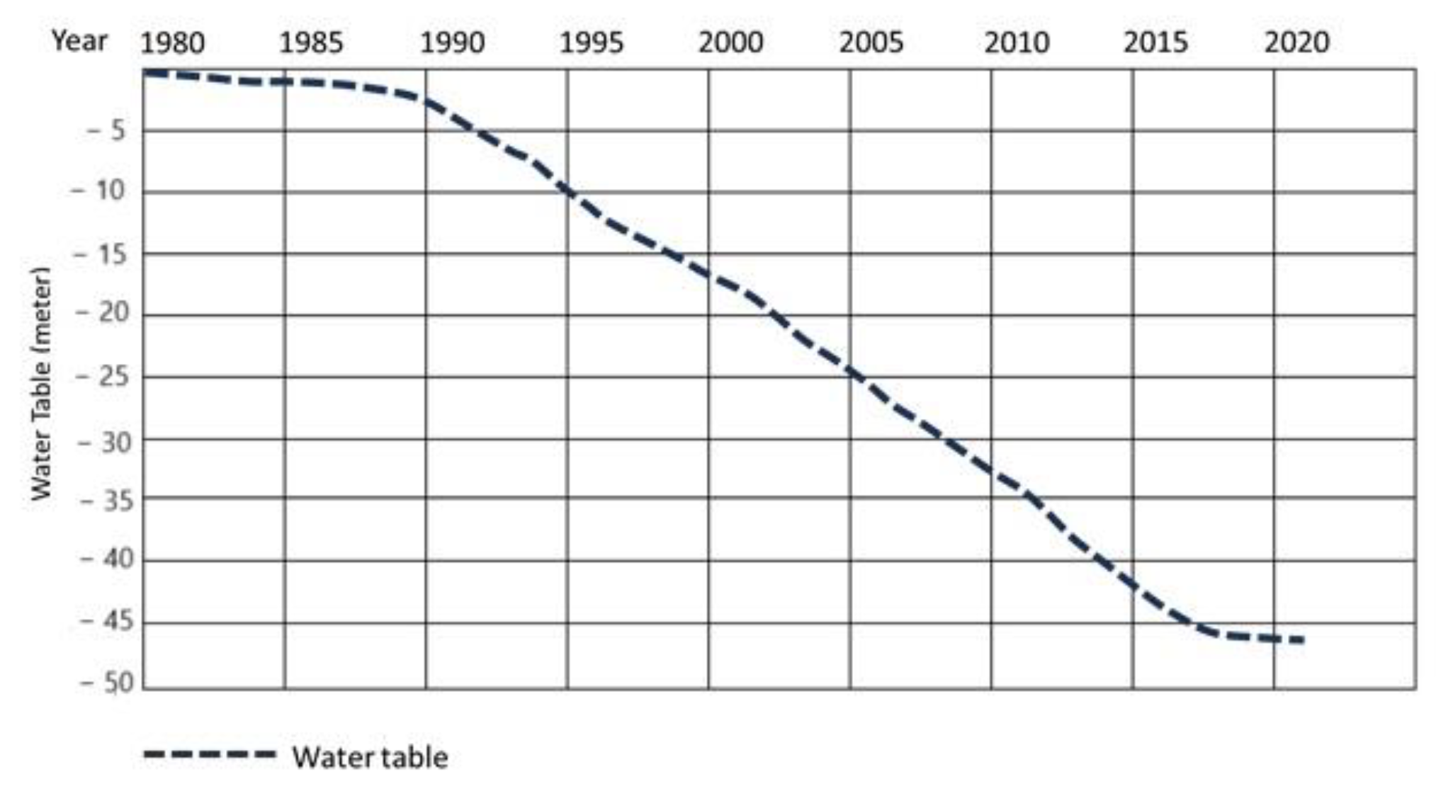
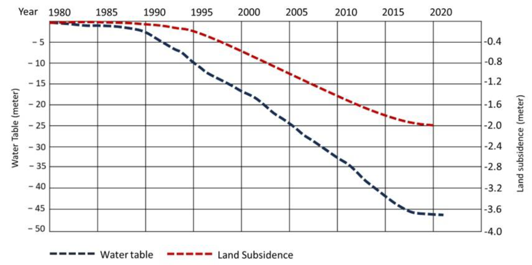
3.2. Batik’s Indirect Contribution to Land Subsidence and Coastal Inundation

Batik production indirectly contributes to land subsidence and coastal inundation through various mechanisms. The overexploitation of groundwater for batik production can lead to land subsidence, as seen in Jakarta, Indonesia, where groundwater extraction has resulted in spatial and temporal variations in land subsidence [19]. This land subsidence can exacerbate the risk of coastal inundation, especially in low-lying coastal areas, by reducing the elevation of the land and increasing the vulnerability to flooding [20].
The extraction of water for batik production, along with other industrial and agricultural activities, can contribute to subsidence in delta regions, such as the Mekong Delta in Vietnam, where land use changes amplify natural subsidence processes [21]. This subsidence, coupled with sea level rise, can increase the risk of inundation in these areas [22]. The cumulative effects of land subsidence from various activities, including batik production, can lead to increased vulnerability to sea level rise and coastal flooding, as observed in Cartagena, Colombia, where subsidence rates have reached up to 72.3 mm [23]. This subsidence, combined with sea level rise, can significantly heighten the risk of coastal inundation and exacerbate flooding in coastal regions [24].
Extensive groundwater extraction has led to a significant decline in water tables. Monitoring the water table can serve as an effective indicator of potential land subsidence in a given area. As the water table drops due to groundwater extraction or prolonged drought conditions, the likelihood of subsidence increases. Studies have shown that fluctuations in the water table can directly correlate with land subsidence rates. For instance, daily and seasonal variations in the water table can lead to measurable land subsidence, with specific amplitudes observed in response to water level changes [25]. As the water table declines, the risk of subsidence increases, particularly in areas with soft, compressible soils [4,12]. The use of remote sensing technologies, such as Interferometric Synthetic Aperture Radar (InSAR), has proven effective in monitoring land subsidence and correlating it with groundwater level data, allowing for a comprehensive understanding of the subsidence mechanisms [15].
A study documented a drop in groundwater levels by approximately 2–3 m over the past decade in areas with concentrated batik production [26]. This decline threatens the sustainability of groundwater resources. Land subsidence, a direct consequence of excessive groundwater extraction, poses severe risks. Another study reported land subsidence has occurred in almost all Pekalongan city areas at 2–12 cm/year rates, correlating these rates with intensive groundwater pumping for industrial purposes, including batik production [27]. Subsidence leads to infrastructure damage, increased flood risks, and disruptions to daily life.
The significant rate of groundwater extraction in the past 40 years has led to a substantial decline in the water table, averaging 1.25 m per year, as can be seen from Figure 4. This has also resulted in land subsidence, with the ground sinking by a total of 2 m during the same period. The strong correlation between the accelerated groundwater depletion and the observed land subsidence underscores the critical need for sustainable water management strategies to prevent further environmental damage and protect the region’s infrastructure and ecosystems from long-term harm.
Based on the interpolation and extrapolation of GNSS measurements and land use changes from 1990 to 2020, it is evident that areas experiencing ground subsidence of more than 2 m have expanded significantly beyond Pekalongan. This expansion is particularly noticeable along the northern coast of Java, from Ujungnegoro Beach, Pasir Kencana Beach, Wonokerto Beach, to Blendung Beach. Additionally, areas around the Pemalang–Batang toll road have also been affected by subsidence exceeding 2 m. The data reveal that land subsidence in the Pekalongan region has worsened dramatically over the decades, spreading to critical coastal and infrastructural zones. This alarming trend highlights the urgent need for comprehensive mitigation measures to address the growing impacts of subsidence on the northern coast of Java and essential infrastructure like the Pemalang–Batang toll road (Figure 5).
Satellite imagery in Figure 6 highlights the dramatic changes in the Pekalongan area over the past 20 years. In 2003, the coastline was well-defined with no signs of coastal inundation, showing that land areas were not affected by seawater. However, the 2023 image reveals a significant shift, with numerous areas now facing coastal inundation, including Jeruksari, Bandengan, Kali Pencongan, Wonokerto, Desa Semut, Depok Siwalan, and Kandang Panjang. This major transformation underscores the intrusion of seawater, which has reshaped the coastline and affected both the environment and local infrastructure.
Coastal inundation is a critical indicator of several environmental challenges, including saltwater intrusion, ecosystem disruption, increased flooding, and significant socio-economic impacts. As seawater encroaches on coastal aquifers, saltwater intrusion can contaminate freshwater resources, rendering groundwater unsuitable for drinking and irrigation, which disrupts agricultural practices [22,28]. Inundation also alters coastal ecosystems, leading to the loss of essential habitats like wetlands and mangroves. The degradation of these ecosystems can have far-reaching effects on local wildlife and fisheries. Additionally, regular inundation accelerates coastal erosion, threatening land and infrastructure, while also increasing the vulnerability of coastal communities to future flooding events [29]. The socio-economic impacts are equally severe, as inundation risks human settlements, infrastructure, and economic activities, leading to the displacement of communities, property damage, and the loss of livelihoods, all of which result in considerable economic losses and social upheaval [30].
Field documentation in Figure 7 captures the current state of the Pekalongan area, where many locations are now facing coastal inundation. The images show houses partially submerged, with floodwaters entering living spaces and reaching significant heights. Moreover, the photos poignantly depict children trying to cope with these harsh conditions, demonstrating their resilience as they move through the flooded areas of their homes. These visuals emphasise the profound impact that coastal flooding has on the daily lives and living conditions of the local community.

3.3. The Potential of Water Cadastre Systems to Mitigate the Effects

The land of the city of Pekalongan has steadily sunk, causing damage to infrastructure, agricultural lands, and displacing communities, while the intrusion of seawater has further exacerbated the environmental degradation. Addressing these interconnected issues requires a holistic and sustainable approach to water management. One potential solution lies in the implementation of a water cadastre system, which systematically manages and monitors water resources. By integrating legal, technical, and environmental frameworks, a water cadastre can provide accurate data on groundwater usage, help regulate extraction, and mitigate the risks of subsidence. This solution not only offers a means to preserve Pekalongan’s cultural and economic assets but also promotes environmental protection and long-term resilience. Water cadastre refers to a systematic and comprehensive registry that documents the quantity, quality, and distribution of water resources within a specific region. It serves as a crucial tool for water resource management, enabling authorities to monitor and assess water bodies, including rivers, lakes, and wetlands, as well as their associated ecosystems. The water cadastre is essential for ensuring sustainable water use, facilitating legal and regulatory compliance, and supporting decision-making processes related to water management and conservation efforts.
The concept of water cadastre illustrated in Figure 8 encompasses various aspects, including the classification and mapping of water bodies, the assessment of their hydrological characteristics, and the establishment of legal frameworks governing water use and rights. For instance, research has highlighted the importance of water cadastre legislation in countries like Uzbekistan, where it plays a vital role in improving water resource management and transparency in governance [31]. Furthermore, the classification of water bodies within cadastre systems is critical for understanding their ecological roles and for implementing effective management strategies [32].
In addition to its legal and administrative functions, a water cadastre plays a critical role in supporting scientific research and environmental monitoring. Studies indicate that accurate cadastral data can greatly improve the understanding of hydrological processes and the impacts of human activities on water resources [33]. This becomes especially relevant in the context of climate change, where effective water management is essential for sustaining ecosystem health and resilience [34]. The integration of modern technologies, such as GIS and remote sensing, into water cadastre systems has further enhanced the accuracy and efficiency of data collection and analysis, significantly improving the overall management of water resources [35]. Unfortunately, land data management in Indonesia remains inadequate. However, with the enactment of the Ministry of Agrarian Affairs and Spatial Planning/National Land Agency Regulation No. 6 of 2018 regarding Complete Systematic Land Registration (Pendaftaran Tanah Sistematis Lengkap) on 22 March 2018, the government has made serious efforts to update the land data system. This progress could serve as a momentum to integrate water management and land management into a unified system, creating a more comprehensive and mutually reinforcing framework.
One notable success story in the implementation of a water cadastre can be found in the Netherlands, where the Dutch water management system has effectively integrated a comprehensive water cadastre framework. This system has been instrumental in managing water resources, particularly in the context of flood risk management and groundwater extraction, which are critical issues in a country characterised by low-lying topography and significant water bodies.
The Dutch water cadastre, known as the “Water Register”, is a centralised database that records all water-related information, including the rights to water extraction, the status of water bodies, and the quality of water resources. This framework is governed by the Water Act, which provides a legal basis for water management and ensures that all water users are registered and monitored. The integration of GIS technology into the water cadastre has allowed for precise mapping and monitoring of water resources, enabling authorities to make informed decisions regarding water allocation and management.
One of the significant achievements of the Dutch water cadastre is its role in managing groundwater extraction. The system has facilitated the establishment of sustainable groundwater management practices by providing accurate data on groundwater levels and usage patterns. This has been particularly important in regions facing land subsidence due to excessive groundwater extraction, such as the Haarlemmermeer polder [36]. By regulating extraction rates and promoting artificial recharge methods, the Dutch water cadastre has successfully mitigated the impacts of subsidence and ensured the sustainability of groundwater resources [37].
The success of the Dutch water cadastre can also be attributed to its emphasis on stakeholder engagement and transparency. The system allows for public access to water-related data, fostering a culture of accountability among water users and management authorities. This transparency has encouraged compliance with water regulations and has facilitated collaborative water management efforts among various stakeholders, including local communities, agricultural producers, and industrial users [38].
The Dutch experience demonstrates that a well-structured water cadastre can significantly enhance water resource management and address challenges related to groundwater extraction and land subsidence. Key lessons from this success story include the importance of integrating legal frameworks with technological solutions, the necessity of stakeholder engagement, and the value of transparent data management practices. These elements can serve as a model for other countries looking to implement similar systems to manage their water resources effectively [39].
From this literature, the concept of a water cadastre can indeed serve as a potential solution to mitigate the adverse effects of groundwater extraction that exacerbate land subsidence conditions. A water cadastre, by systematically documenting and managing water resources, can play a crucial role in regulating groundwater extraction and promoting sustainable practices. Implementing a water cadastre can help monitor groundwater levels and usage, thereby providing data that can inform policies aimed at reducing extraction rates and preventing subsidence [40].
Moreover, a well-structured water cadastre can facilitate the identification of critical areas where groundwater extraction is unsustainable. For instance, in regions like Beijing, the integration of hydrogeological data into water management practices has been shown to mitigate subsidence trends [41]. By employing advanced monitoring techniques and data analysis, a water cadastre can support the development of effective groundwater management strategies that balance human needs with environmental sustainability [42].
In addition to monitoring and regulation, a water cadastre can also promote the implementation of artificial recharge techniques, which have been shown to alleviate subsidence by replenishing aquifers. For example, in areas experiencing severe subsidence due to groundwater depletion, water injection methods have been effective in slowing down the rate of subsidence [43]. By providing a comprehensive framework for managing water resources, a water cadastre can enhance the resilience of groundwater systems and contribute to the long-term sustainability of both water resources and the land above them. The establishment of a water cadastre presents a viable solution to address the challenges posed by groundwater extraction and land subsidence.
To implement a water cadastre as one of the best solutions for land and water management in the Pekalongan area and to curb the rate of groundwater extraction and land subsidence, a water cadastre framework must be established. Building a water cadastre framework involves several critical steps that integrate legal, technical, and organisational aspects to ensure effective management of water resources. This framework aims to provide a comprehensive system for monitoring, regulating, and managing water bodies, particularly groundwater, to mitigate issues such as land subsidence caused by excessive extraction.
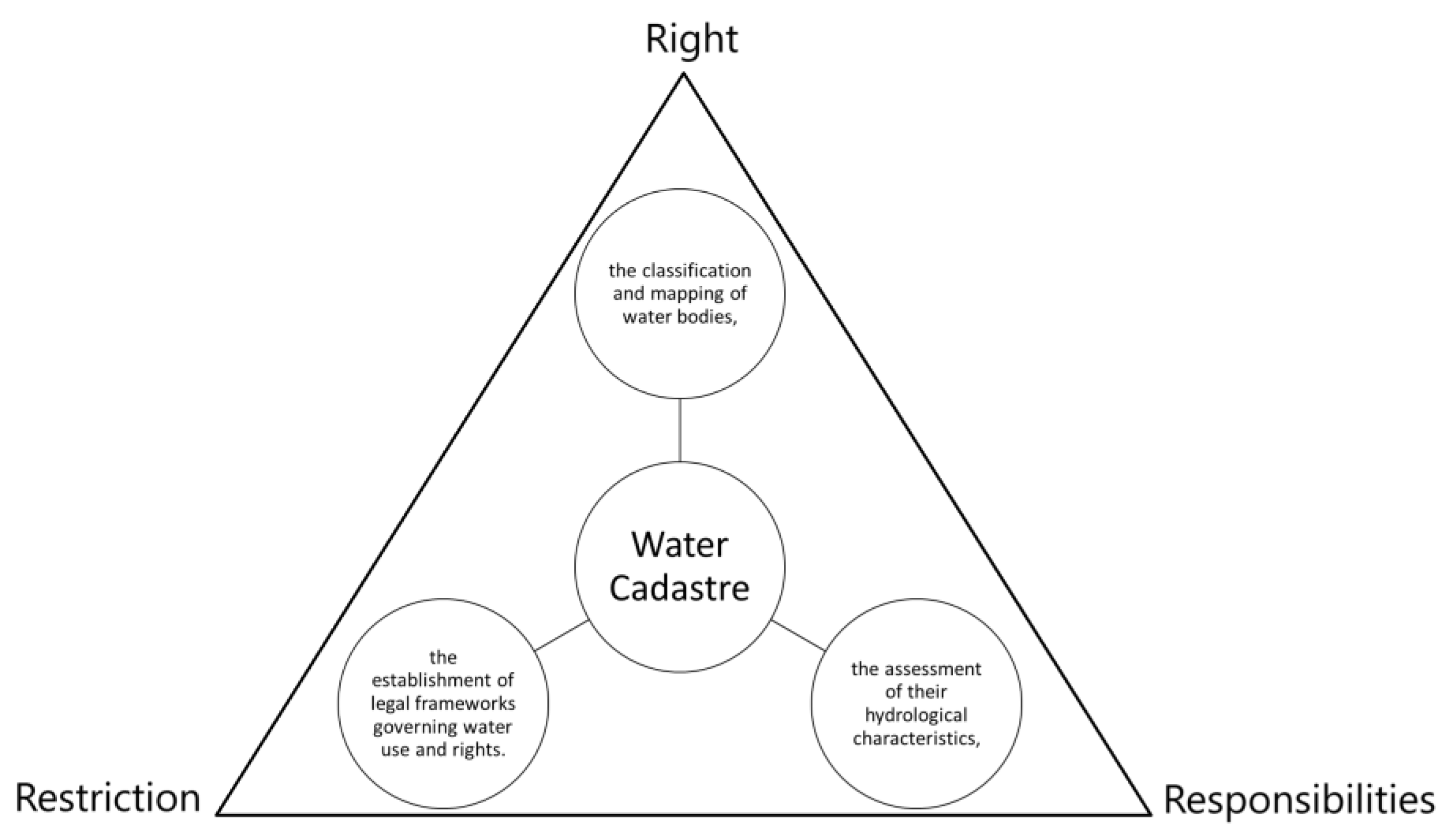
  • Legal and Institutional Framework: Establishing a robust legal framework is essential for the implementation of a water cadastre. This includes defining water rights, responsibilities, and restrictions associated with water use. The framework should align with existing water management policies, such as the EU Water Framework Directive, which emphasises sustainable water management practices [44]. Additionally, the integration of local and national governance structures is crucial to ensure that the cadastre operates effectively across different administrative levels.
  • Data Collection and Management: A comprehensive water cadastre requires systematic data collection on various aspects of water resources, including quantity, quality, and usage patterns. This involves utilising modern technologies such as Geographic Information Systems (GISs) and Building Information Modelling (BIM) to create detailed spatial representations of water bodies. Data should be collected from various sources, including remote sensing, hydrological studies, and community reporting, to ensure a holistic understanding of the water landscape (“Climate indicators of changes in hydrological characteristics (a case of the Psyol river basin)”, 2020).
  • Stakeholder Engagement and Participation: Engaging stakeholders, including local communities, governmental agencies, and environmental organisations, is vital for the success of a water cadastre. Participatory planning processes can enhance the legitimacy and effectiveness of water management strategies [44]. Stakeholders can provide valuable insights into local water issues and contribute to the development of management practices that are socially acceptable and environmentally sustainable.
  • Implementation of Monitoring Systems: To effectively manage water resources, the water cadastre should incorporate monitoring systems that track changes in water levels, quality, and usage over time. This could involve the deployment of sensors and remote sensing technologies to gather real-time data [41,43]. Regular monitoring can help identify trends in groundwater extraction and its impacts on land subsidence, allowing for timely interventions [45].
  • Integration with Existing Cadastral Systems: The water cadastre should be integrated with existing land and property cadastre systems to provide a comprehensive view of land and water interactions. This integration can facilitate better decision-making regarding land use and water management, ensuring that both resources are managed sustainably [46]. The use of a Land Administration Domain Model (LADM) can also help standardise data and processes across different jurisdictions.

4. Conclusions

This study examined the intersection of batik production and environmental sustainability in Pekalongan, highlighting the significant cultural and economic importance of this traditional Indonesian craft while addressing its adverse environmental impacts. The research reveals that while batik production is a vital economic driver, generating approximately USD 52.44 million annually and supporting over 15,000 artisans, it also poses serious environmental challenges. The dyeing process results in substantial wastewater discharge, leading to elevated levels of pollutants in surface and groundwater, which in turn exacerbates groundwater overextraction and contributes to land subsidence.
Key findings include the following:
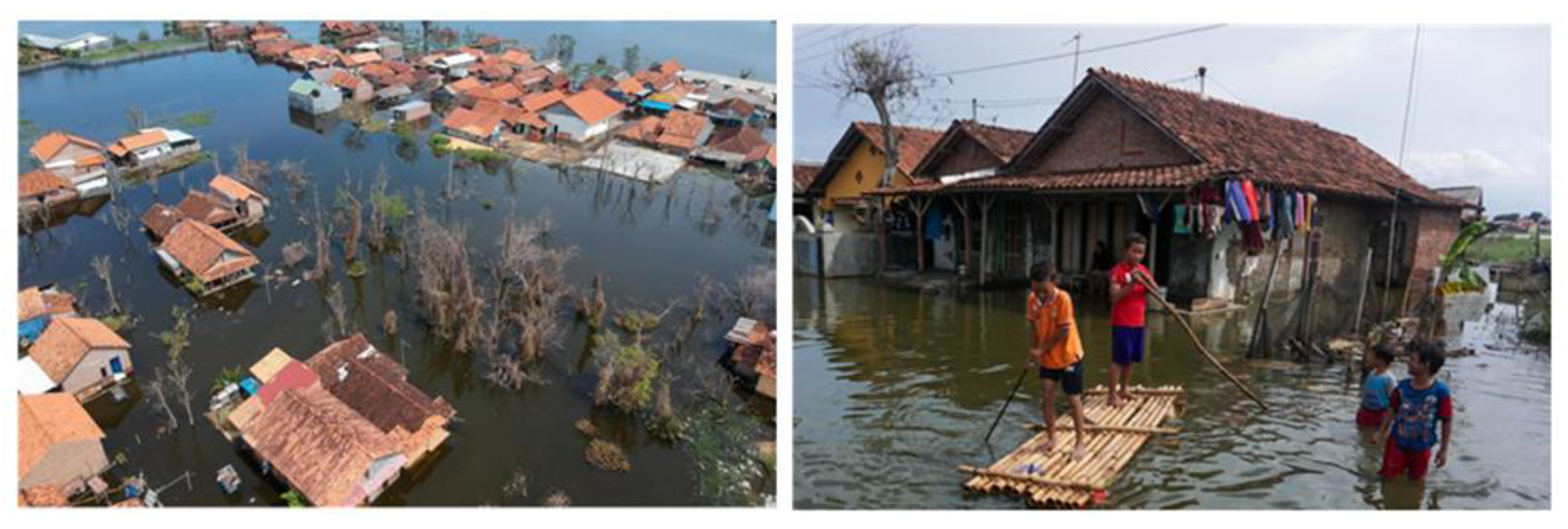
  • Groundwater Depletion and Land Subsidence: The study documents a significant decline in groundwater levels over the past 20 years, averaging a decrease of 4 m per year between 2005 and 2015. This reduction is linked to increased land subsidence, with subsidence rates averaging 1–2 cm per year in areas with intensive batik production. This phenomenon has led to severe infrastructure damage and increased flooding risks in Pekalongan.
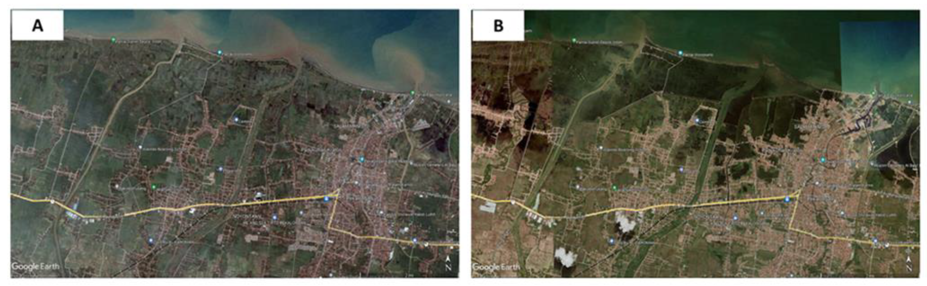
  • Coastal Inundation: Satellite imagery indicates a dramatic shift in coastal conditions from 2003 to 2023, with many areas now experiencing coastal inundation. This change is attributed to saltwater intrusion and accelerated coastal erosion, affecting local ecosystems, agriculture, and socio-economic conditions.
  • Water Cadastre Framework: The study proposes the implementation of a water cadastre framework to manage groundwater resources sustainably. This framework includes legal and institutional structures, comprehensive data collection through GIS and remote sensing, stakeholder engagement, and integrated monitoring systems. The Dutch water cadastre model serves as a successful example, demonstrating the benefits of accurate data and stakeholder involvement in managing groundwater extraction and mitigating subsidence.
The implications of these findings are profound. Addressing the environmental impacts of batik production is crucial for preserving Pekalongan’s cultural heritage while ensuring environmental sustainability. The integration of a water cadastre framework offers a practical solution for managing groundwater resources and mitigating subsidence, providing a model for other regions facing similar challenges.
This research contributes to the existing body of knowledge by linking traditional industries with modern environmental management practices. It underscores the need for sustainable approaches that reconcile cultural preservation with environmental stewardship. Future research should explore the long-term effectiveness of water cadastre implementations in various contexts, assess the impact of artificial recharge techniques on subsidence, and evaluate the socio-economic outcomes of integrating environmental management with cultural industries. Additionally, studies could investigate the role of policy frameworks and community engagement in enhancing the sustainability of traditional practices.

Author Contributions

Conceptualisation, A.P.H. and H.A.; methodology, A.P.H. and H.A.; software, D.P.; validation, A.P.H., H.A. and D.P.; formal analysis, A.P.H.; investigation, H.A.; resources, H.A.; data curation, D.P.; writing, A.P.H.; writing—review and editing, A.P.H., H.A. and D.P.; visualisation, A.P.H., H.A. and D.P.; supervision, H.A.; project administration, A.P.H. All authors have read and agreed to the published version of the manuscript.

Funding

This research funded by the Research, Community Service, and Innovation (PPMI) program of the Faculty of Earth Sciences and Technology, Institut Teknologi Bandung (ITB). FITB.PPMI-1-14-2024.

Institutional Review Board Statement

Not applicable.

Informed Consent Statement

Informed consent was obtained from all subjects involved in the study.

Data Availability Statement

Data are unavailable due to privacy or ethical restrictions.

Acknowledgments

The authors are grateful to all individuals including editors and organisations who contributed to this research, especially Walter Timo de Vries from Technische Universität München who has provided exceptional input to the author regarding the potential of a water cadastre.

Conflicts of Interest

The authors declare no conflicts of interest.

References

  1. Surya, R.; Fadlil, A.; Yudhana, A. Identification of Pekalongan batik images using backpropagation method. J. Phys. Conf. Ser. 2019, 1373, 012049. [Google Scholar] [CrossRef]
  2. Steelyana, E. Batik, a beautiful cultural heritage that preserve culture and supporteconomic development in Indonesia. Binus Bus. Rev. 2012, 3, 116. [Google Scholar] [CrossRef]
  3. Xiao, M. Innovative applications and market impact of Indonesian batik in modern fashion. Studies in Art and Architecture. Stud. ArtArchit. 2024, 3, 62–66. [Google Scholar] [CrossRef]
  4. Fadhila, E. Implementation of batik wastewater management policy: A case study of Pekalongan city. J. Ilm. Ilmu Adm. Publik 2023, 13, 825. [Google Scholar] [CrossRef]
  5. Kamis, A.; Syamwil, R.; Widowati, W.; Fadia, I.; Milannis, A. Weeds as an environmentally friendly alternative dyes. IOP Conf. Ser. Earth Environ. Sci. 2022, 969, 012037. [Google Scholar] [CrossRef]
  6. Budiyanto, S.; Purnaweni, H.; Sunoko, H.R. Environmental Analysis of The Impacts of Batik Waste Water Polution on The Quality of Dug Well Water in The Batik Industrial Center of Jenggot Pekalongan City. E3S Web Conf. 2018, 31, 09008. [Google Scholar] [CrossRef]
  7. Levi, P.; Hunga, A.; Sidabalok, H. The venture for clean batik production: Input analysis on natural dyeing in batik micro-collectives in Klaten, Central Java, Indonesia. In Proceedings of the 3rd International Conference on Gender Equality and Ecological Justice, Salatiga, Central Java, Indonesia, 10–11 July 2019. [Google Scholar] [CrossRef]
  8. Latifah, N.R. Preparation and characterization of adsorbent from natural zeolite mixed chicken feather in degradation of batik waste dyes based green chemistry. J. Kim. Dan Pendidik. Kim. 2021, 6, 362. [Google Scholar] [CrossRef]
  9. Hati, A.; Putranto, T.; Budihardjo, M. Escalate groundwater potential for acquiring sustainability and resilience in Pekalongan city, Indonesia—A review. E3S Web Conf. 2020, 202, 06007. [Google Scholar] [CrossRef]
  10. Ismanto, A.; Hadibarata, T.; Widada, S.; Atmodjo, W.; Satriadi, A.; Siagian, H.; Safinatunnajah, N. Heavy metal contamination in the marine environment of Pekalongan, Indonesia: Spatial distribution and hydrodynamic modeling. Environ. Qual. Manag. 2023, 33, 37–46. [Google Scholar] [CrossRef]
  11. Hariani, D.; Eliza, E.; Pratama, D. Study of creative industry development based on Pekalongan batik culture. In Proceedings of the 1st Workshop on Environmental Science, Society, and Technology (WESTECH) 2018, Medan, Indonesia, 8 December 2018. [Google Scholar] [CrossRef]
  12. Maninggar, N.; Hudalah, D.; Sutriadi, R.; Firman, T. Low-tech industry, regional innovation system and inter-actor collaboration in Indonesia: The case of the Pekalongan batik industry. Asia Pac. Viewp. 2018, 59, 249–264. [Google Scholar] [CrossRef]
  13. Masrur, M.; Arwani, A. Work ethic and strategic development of batik Pekalongan Indonesia on islamic business perspective. J. Ekon. Syariah Indones. 2020, 10, 67. [Google Scholar] [CrossRef]
  14. Marwah, S.; Pratiwi, O.; Ramadhanti, W.; Shania, N. Java north coast women’s contribution to economic and religious dynamics: It is time to be a public knowledge. Kne Soc. Sci. 2023, 8, 519–530. [Google Scholar] [CrossRef]
  15. Adinugraha, H. Marketing endorsement strategy in batik kampus: Islamic business ethics perspective. Sci. J. Has. Penelit. 2021, 6, 9–21. [Google Scholar] [CrossRef]
  16. Rukayah, R.S.; Juwono, S.; Susilo, S.E.S.; Puguh, D.R. Post office and traditional city center square as city linkage in java. Environ.-Behav. Proc. J. 2019, 4, 126. [Google Scholar] [CrossRef]
  17. Handayani, W.; Budi, W.Y.; Rika, P.A. Addressing the Debate on the Eco-Friendliness of Indonesian Batik by Water Footprint Approach. J. Environ. Sci. Sustain. Dev. 2023, 6, 116–131. [Google Scholar] [CrossRef]
  18. Kristijanto, A.I.; Handayani, W.; Levi, P.A.A. The effectiveness of anaerobic baffled reactor and rotating biological contactor in batik wastewater treatment. Makara J. Technol. 2011, 15, 168172. [Google Scholar] [CrossRef]
  19. Abidin, H.Z.; Andreas, H.; Gumilar, I.; Fukuda, Y.; Pohan, Y.E.; Deguchı, T. Land subsidence of Jakarta (Indonesia) and its relation with urban development. Nat. Hazards 2011, 59, 1753–1771. [Google Scholar] [CrossRef]
  20. Li, P.; Wang, G.; Liang, C.; Wang, H.; Li, Z. Insar-derived coastal subsidence reveals new inundation scenarios over the yellow river delta. IEEE J. Sel. Top. Appl. Earth Obs. Remote Sens. 2023, 16, 8431–8441. [Google Scholar] [CrossRef]
  21. Minderhoud, P.; Coumou, L.; Erban, L.; Middelkoop, H.; Stouthamer, E.; Addink, E. The relation between land use and subsidence in the vietnamese mekong delta. Sci. Total Environ. 2018, 634, 715–726. [Google Scholar] [CrossRef]
  22. Shirzaei, M.; Bürgmann, R. Global climate change and local land subsidence exacerbate inundation risk to the San Francisco bay area. Sci. Adv. 2018, 4, eaap9234. [Google Scholar] [CrossRef]
  23. Restrepo-Ángel, J.; Mora-Páez, H.; Díaz, F.; Govorčin, M.; Wdowinski, S.; Giraldo-Londoño, L.; Tosic, M.; Fernández, I.; Paniagua-Arroyave, J.F.; Duque-Trujillo, J.F. Coastal subsidence increases vulnerability to sea level rise over twenty first century in cartagena, caribbean colombia. Sci. Rep. 2021, 11, 18873. [Google Scholar] [CrossRef]
  24. Reed, A.J.; Mann, M.E.; Emanuel, K.A.; Lin, N.; Horton, B.P.; Kemp, A.C.; Donnelly, J.P. Increased threat of tropical cyclones and coastal flooding to New York City during the anthropogenic era. Proc. Natl. Acad. Sci. USA 2015, 112, 12610–12615. [Google Scholar] [CrossRef] [PubMed]
  25. Antonellini, M.; Pandolfini, M.; Greggio, N.; Mollema, P. Geothermal characterization of the coastal aquifer near Ravenna (Italy). Acque Sotter.-Ital. J. Groundw. 2012, 1, 19–30. [Google Scholar] [CrossRef]
  26. Abidin, H.Z.; Andreas, H.; Gumilar, I.; Wangsaatmaja, S.; Fukuda, Y.; Deguchi, T. Land subsidence and groundwater extraction in Bandung Basin, Indonesia. IAHS-AISH Publ. 2009, 329, 145. [Google Scholar]
  27. Sarah, D.; Soebowo, E.; Sudrajat, Y.; Satriyo, N.A.; Putra, M.H.Z.; Wahyudin. Mapping the environmental impacts from land subsidence hazard in Pekalongan City and its correlation with the subsurface condition. IOP Conf. Ser. Earth Environ. Sci. 2023, 1201, 012044. [Google Scholar] [CrossRef]
  28. Ouyang, M.; Ito, Y.; Tokunaga, T. Local land subsidence exacerbates inundation hazard to the Kujukuri Plain, Japan. Proc. Int. Assoc. Hydrol. Sci. 2020, 382, 657–661. [Google Scholar] [CrossRef]
  29. Wibowo, P.; Hartoko, A.; Ambariyanto, A. Land subsidence affects coastal zone vulnerability (pengaruh penurunan tanah terhadap kerentanan wilayah pesisir). Ilmu Kelaut. Indones. J. Mar. Sci. 2015, 20, 127. [Google Scholar] [CrossRef]
  30. Ward, P.J.; Marfai, M.A.; Yulianto, F.; Hizbaron, D.R.; Aerts, J.C.J.H. Coastal inundation and damage exposure estimation: A case study for Jakarta. Nat. Hazards 2011, 56, 899–916. [Google Scholar] [CrossRef]
  31. Toshboyeva, R. Issues of further improving the water cadastre legislation of Uzbekistan. Rev. Law Sci. 2021, 5, 71–87. [Google Scholar] [CrossRef]
  32. Petrakovska, O.; Dubnytska, M. Features of cadastral accounting and monitoring of water facilities in Ukraine. Transf. Innov. Technol. 2018, 1, 26–35. [Google Scholar] [CrossRef]
  33. Kwartnik-Pruc, A.; Mączyńska, A. Methodology of assessing quality of spatial data describing course of shoreline as tool supporting water resource management process. J. Water Land Dev. 2023, 57, 167–180. [Google Scholar] [CrossRef]
  34. Navarra, D.; Molen, P. A global perspective on cadastres and geo-ict for sustainable urban governance in view of climate change. Ace Arquit. Ciudad. Y Entorno 2014, 8, 59–72. [Google Scholar] [CrossRef]
  35. Khilchevskyi, V.; Grebin, V.; Dubniak, S.; Zabokrytska, M.; Bolbot, H. Large and small reservoirs of Ukraine. J. Water Land Dev. 2022, 52, 101–107. [Google Scholar] [CrossRef]
  36. Jung, J.; Su, X.; Baeza, M.; Hong, S. The effect of organizational culture stemming from national culture towards quality management deployment. TQM J. 2008, 20, 622–635. [Google Scholar] [CrossRef]
  37. Horan, R.D.; Shortle, J.S. Economic and ecological rules for water quality trading. JAWRA J. Am. Water Resour. Assoc. 2011, 47, 59–69. [Google Scholar] [CrossRef]
  38. Dey, P.K.; Clegg, B.T.; Bennett, D.J. Managing enterprise resource planning projects. Bus. Process Manag. J. 2010, 16, 282–296. [Google Scholar] [CrossRef]
  39. Robbins, G.; Mulligan, E.; Keenan, F. E-government in the Irish revenue: The Revenue On-line Service (ROS): A success story? Financ. Account. Manag. 2015, 31, 363–394. [Google Scholar] [CrossRef]
  40. Herrera-García, G.; Ezquerro, P.; Tomás, R.; Béjar-Pizarro, M.; López-Vinielles, J.; Rossi, M.; Mateos, R.M.; Carreón-Freyre, D.; Lambert, J.; Teatini, P.; et al. Mapping the global threat of land subsidence. Science 2021, 371, 34–36. [Google Scholar] [CrossRef]
  41. Lin, G.; Gong, H.; Zhu, F.; Zhu, L.; Zhang, Z.; Zhou, C.; Gao, M.; Sun, Y. Analysis of the spatiotemporal variation in land subsidence on the Beijing Plain, China. Remote Sens. 2019, 11, 1170. [Google Scholar] [CrossRef]
  42. Minderhoud, P.; Middelkoop, H.; Erkens, G.; Stouthamer, E. Groundwater extraction may drown mega-delta: Projections of extraction-induced subsidence and elevation of the Mekong delta for the 21st century. Environ. Res. Commun. 2020, 2, 011005. [Google Scholar] [CrossRef]
  43. Aichi, M.; Tokunaga, T. Poroelastic modeling to assess the effect of water injection for land subsidence mitigation. Proc. IAHS 2015, 372, 431–435. [Google Scholar] [CrossRef]
  44. Koontz, T.M.; Newig, J. Cross-level information and influence in mandated participatory planning: Alternative pathways to sustainable water management in Germany’s implementation of the EU water framework directive. Land Use Policy 2014, 38, 594–604. [Google Scholar] [CrossRef]
  45. Gharehdaghi, M.; Fakher, A.; Cheshomi, A. The combined use of long-term multi-sensor insar analysis and finite element simulation to predict land subsidence. Int. Arch. Photogramm. Remote Sens. Spat. Inf. Sci. 2019, 42, 421–427. [Google Scholar] [CrossRef]
  46. Rugland, E. Integrating Land Use and Water Management: Planning and Practice; Lincoln Institute of Land Policy: Cambridge, MA, USA, 2022. [Google Scholar]
Figure 1. First batik villages and the small and medium batik industries area in Pekalongan.
Eesp 33 00008 g001
Figure 2. Field documentation shows surface water being polluted (e.g., colored) by batik industries in Pekalongan (image by Google).
Eesp 33 00008 g002
Figure 3. Result of reconstruction of water table dynamics due to exploitation of groundwater in Pekalongan.
Eesp 33 00008 g003
Figure 4. Result of reconstruction of water table dynamic versus land subsidence due to exploitation of groundwater in Pekalongan.
Eesp 33 00008 g004
Figure 5. Model of subsidence growth around Pekalongan derived from interpolation–extrapolation GNSS measurements and land use change (A = 1990, B = 1990–1995, C = 1990–2000, D = 1990–2005, E = 1990–2010, F = 1995–2020).
Eesp 33 00008 g005
Figure 6. (A) Satellite image showing condition of Pekalongan area in 2003 with no coastal inundation existed, (B) Satellite image showing condition of Pekalongan area in 2023 with many places experiencing coastal inundation.
Eesp 33 00008 g006
Figure 7. Field documentations show the condition of Pekalongan area with many places experiencing coastal inundation.
Eesp 33 00008 g007
Figure 8. The concept of water cadastre.
Eesp 33 00008 g008
Disclaimer/Publisher’s Note: The statements, opinions and data contained in all publications are solely those of the individual author(s) and contributor(s) and not of MDPI and/or the editor(s). MDPI and/or the editor(s) disclaim responsibility for any injury to people or property resulting from any ideas, methods, instructions or products referred to in the content.

