Evaluating the Drainage Density Characteristics on Climate and Drainage Area Using LiDAR Data
Abstract
:1. Introduction
2. Data and Methodology
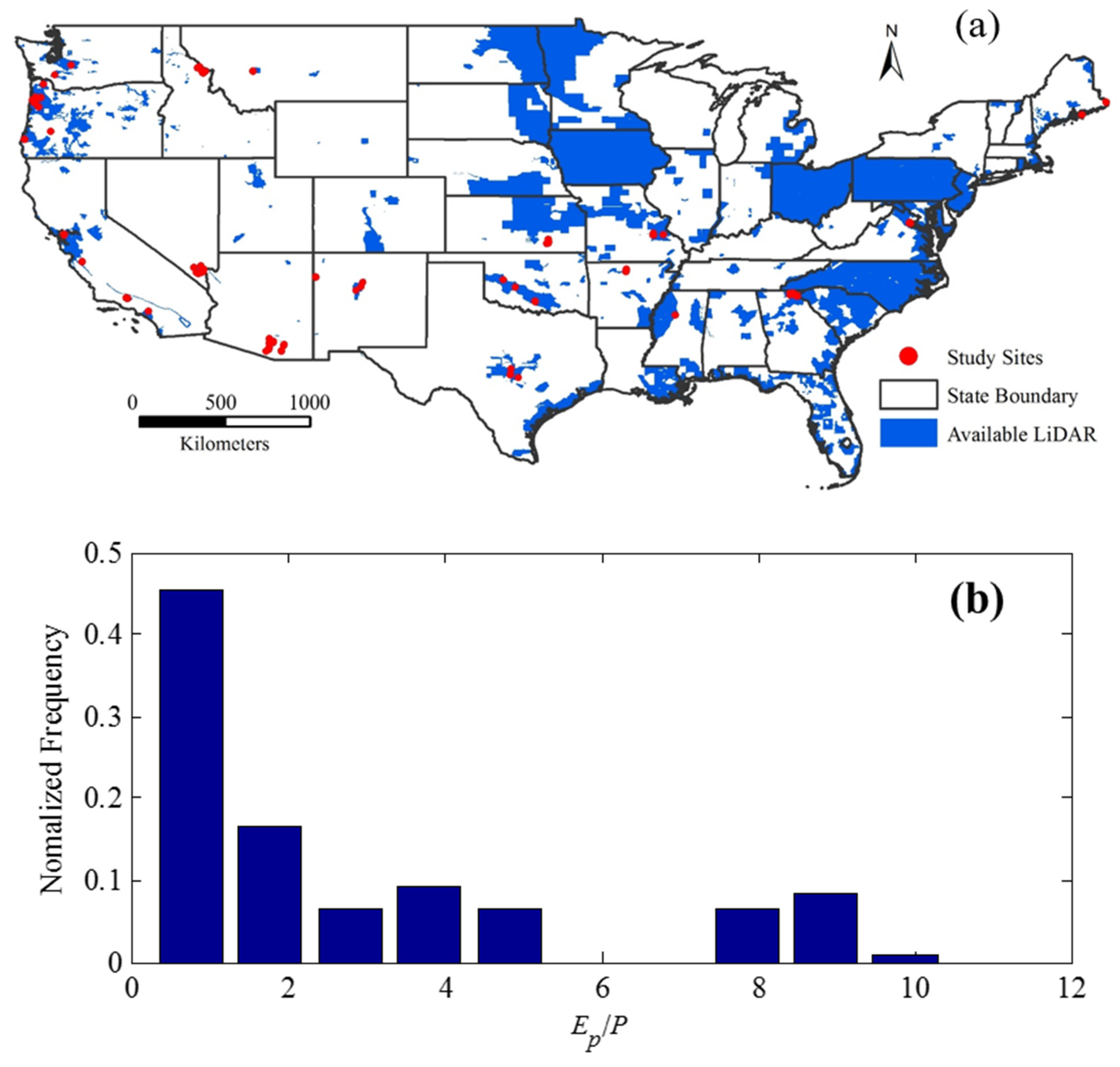
2.1. Study Sites and Data Sources
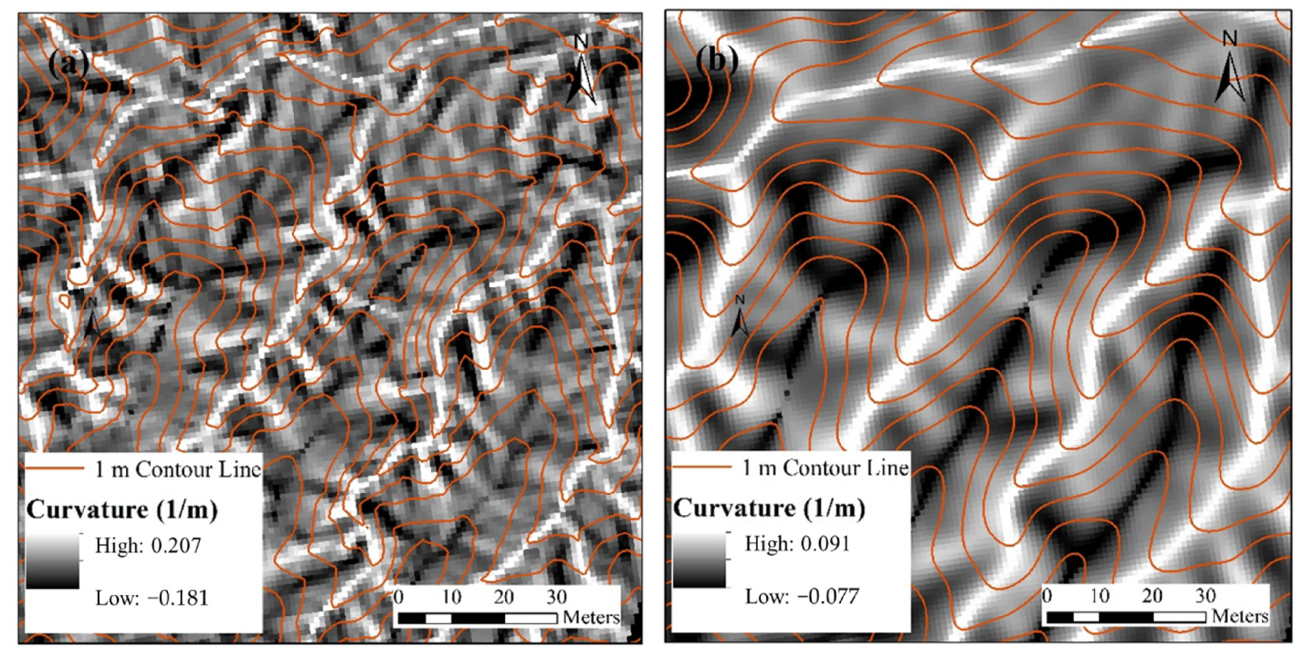
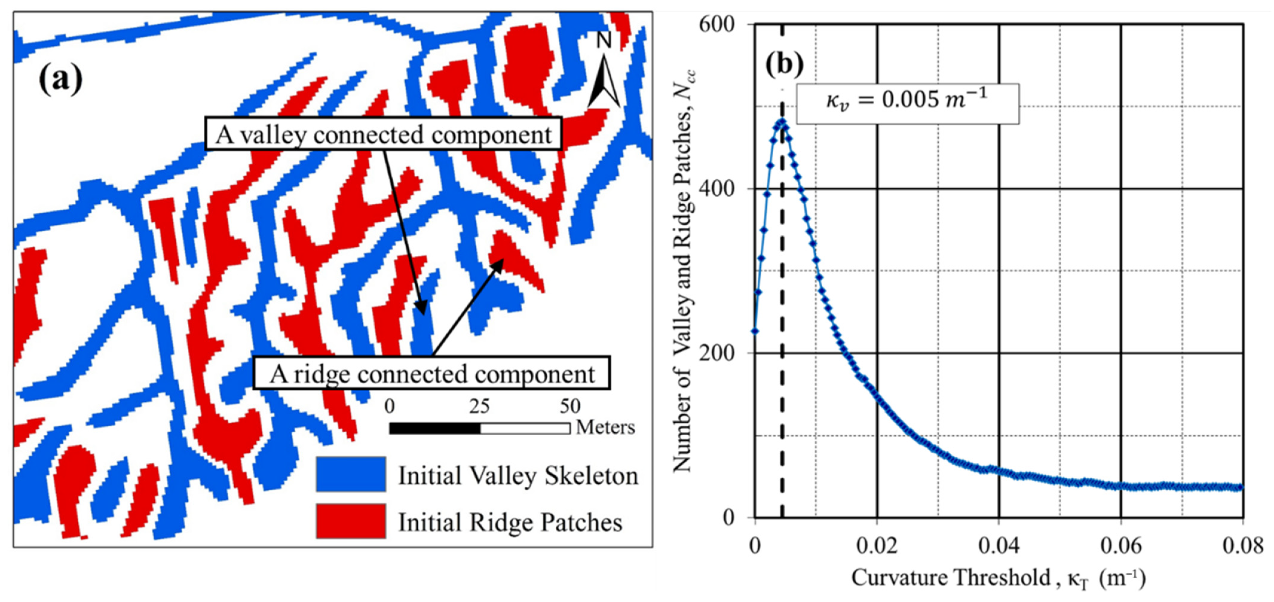
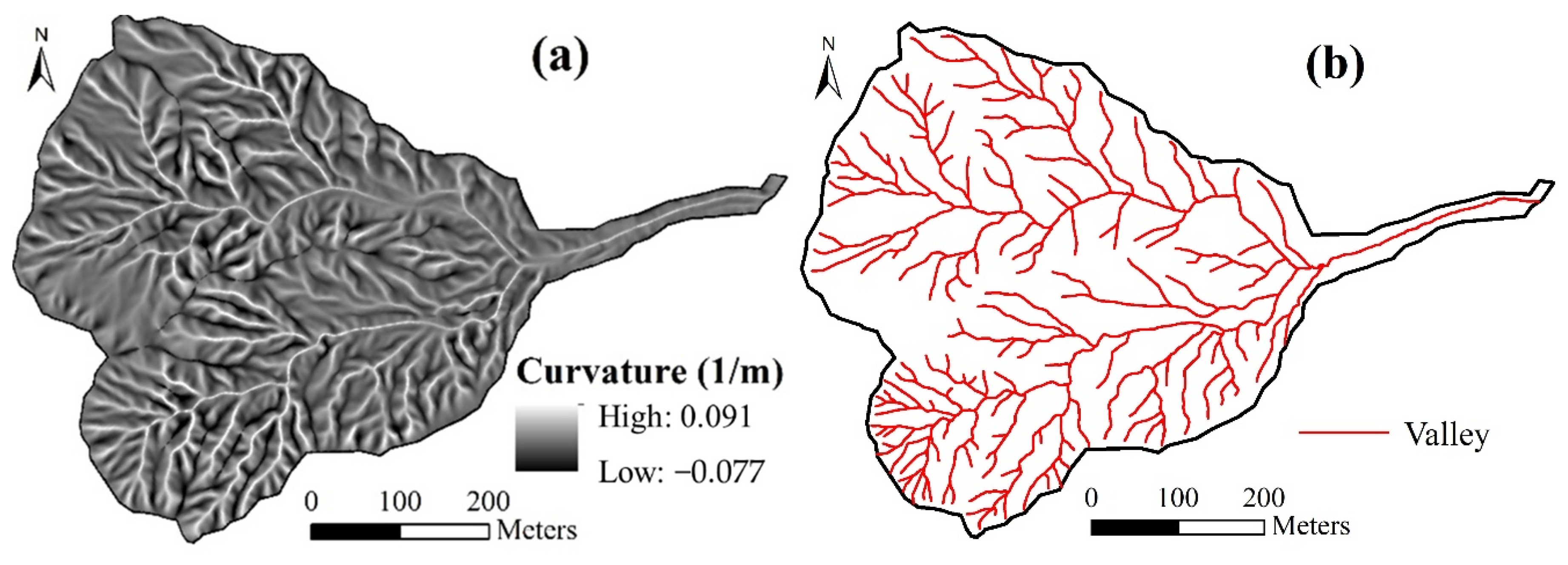
2.2. Valley Network Extraction
3. Results and Discussion
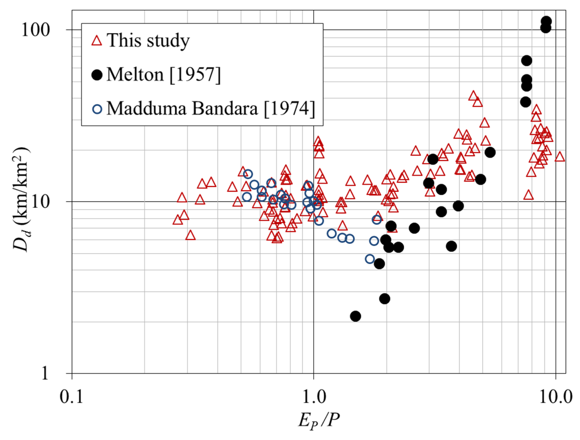
3.1. Relationship between Drainage Density and Climate Aridity Index
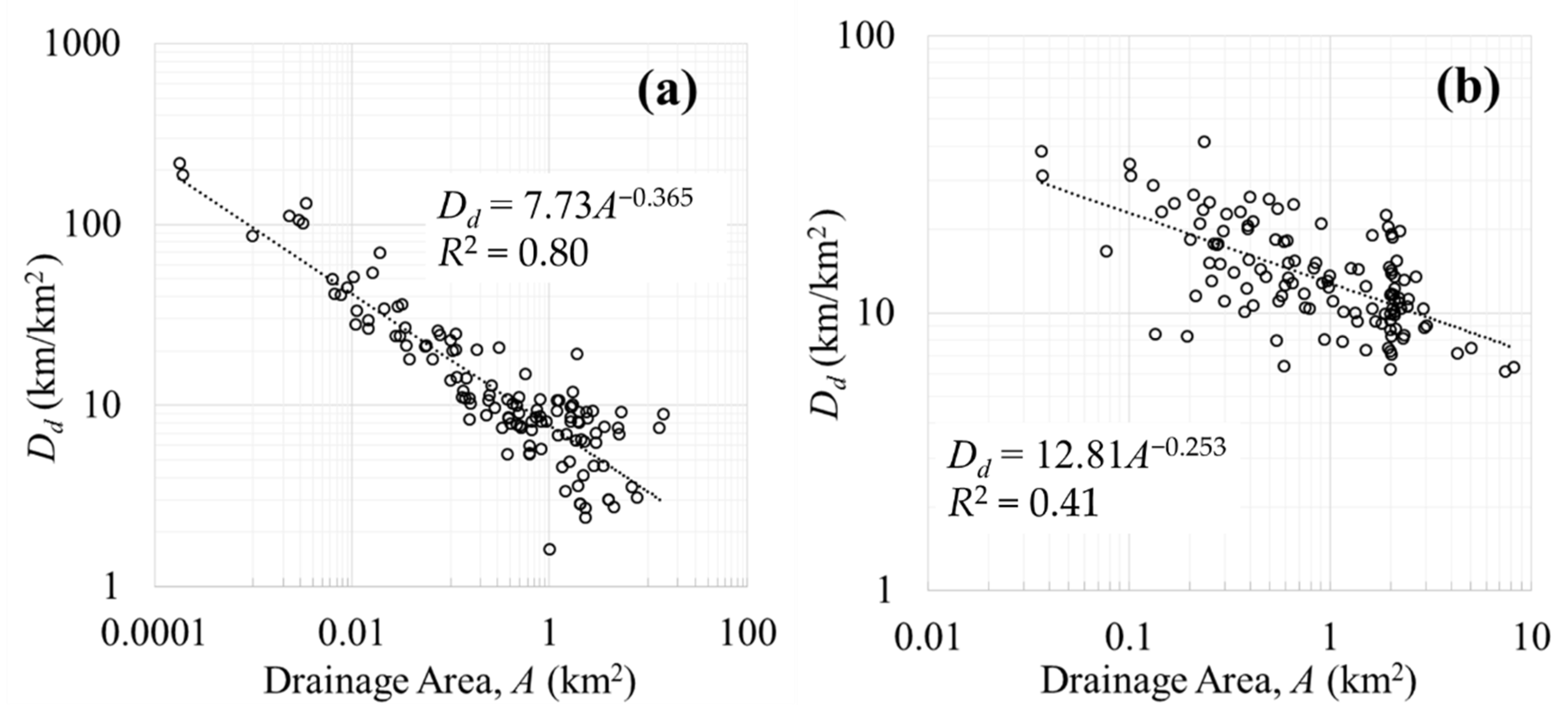
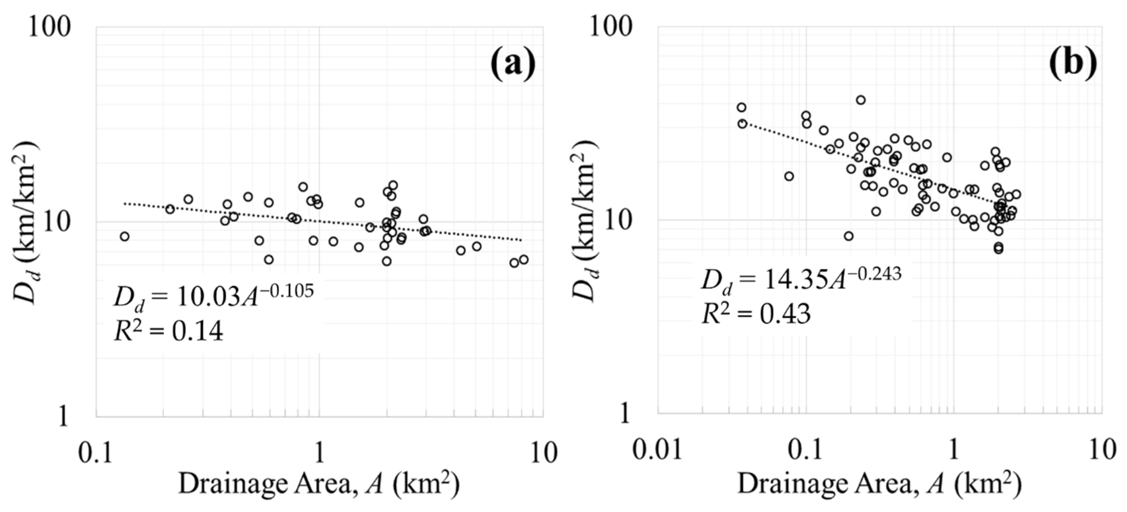
3.2. Impact of Drainage Area on Drainage Density
4. Summary and Conclusions
Author Contributions
Funding
Institutional Review Board Statement
Informed Consent Statement
Data Availability Statement
Acknowledgments
Conflicts of Interest
References
- Montgomery, D.R.; Foufoula-Georgiou, E. Channel network source representation using digital elevation models. Water Resour. Res. 1993, 29, 3925–3934. [Google Scholar] [CrossRef]
- Montgomery, D.R.; Dietrich, W.E. Source areas, drainage density, and channel initiation. Water Resour. Res. 1989, 25, 1907–1918. [Google Scholar] [CrossRef] [Green Version]
- Moglen, G.E.; Eltahir, E.A.; Bras, R.L. On the sensitivity of drainage density to climate change. Water Resour. Res. 1998, 34, 855–862. [Google Scholar] [CrossRef] [Green Version]
- Peucker, T.K.; Douglas, D.H. Detection of surface-specific points by local parallel processing of discrete terrain elevation data. Comput. Graph. Image Process. 1975, 4, 375–387. [Google Scholar] [CrossRef]
- Howard, A.D. A detachment-limited model of drainage basin evolution. Water Resour. Res. 1994, 30, 2261–2285. [Google Scholar] [CrossRef] [Green Version]
- Morisawa, M. Accuracy of determination of stream lengths from topographic maps. Eos Trans. Am. Geophys. Union 1957, 38, 86–88. [Google Scholar] [CrossRef]
- O’Callaghan, J.F.; Mark, D.M. The extraction of drainage networks from digital elevation data. Comput. Vis. Graph. Image Process. 1984, 28, 323–344. [Google Scholar] [CrossRef]
- Band, L.E. Topographic Partition of Watersheds with Digital Elevation Models. Water Resour. Res. 1986, 22, 15–24. [Google Scholar] [CrossRef]
- Tarboton, D.G.; Bras, R.L.; Rodriguez-Iturbe, I. On the extraction of channel networks from digital elevation data. Hydrol. Process. 1991, 5, 81–100. [Google Scholar] [CrossRef]
- Montgomery, D.R.; Dietrich, W.E. Where do channels begin? Nature 1988, 336, 232–234. [Google Scholar] [CrossRef]
- Willgoose, G.; Bras, R.L.; Rodriguez-Iturbe, I. A coupled channel network growth and hillslope evolution model: 1. Theory. Water Resour. Res. 1991, 27, 1671–1684. [Google Scholar] [CrossRef] [Green Version]
- Dietrich, W.E.; Wilson, C.J.; Montgomery, D.R.; McKean, J.; Bauer, R. Erosion thresholds and land surface morphology. Geology 1992, 20, 675–679. [Google Scholar] [CrossRef]
- Dietrich, W.E.; Wilson, C.J.; Montgomery, D.R.; McKean, J. Analysis of erosion thresholds, channel networks, and landscape morphology using a digital terrain model. J. Geol. 1993, 101, 259–278. [Google Scholar] [CrossRef] [Green Version]
- Ijjasz-Vasquez, E.J.; Bras, R.L. Scaling regimes of local slope versus contributing area in digital elevation models. Geomorphology 1995, 12, 299–311. [Google Scholar] [CrossRef]
- Yokoyama, R.; Shirasawa, M.; Pike, R.J. Visualizing topography by openness: A new application of image processing to digital elevation models. Photogramm. Eng. Remote Sens. 2002, 68, 257–266. [Google Scholar]
- Le, P.V.; Kumar, P. Power law scaling of topographic depressions and their hydrologic connectivity. Geophys. Res. Lett. 2014, 41, 1553–1559. [Google Scholar] [CrossRef]
- Hooshyar, M.; Kim, S.; Wang, D.; Medeiros, S.C. Wet channel network extraction by integrating LiDAR intensity and elevation data. Water Resour. Res. 2015, 51, 10029–10046. [Google Scholar] [CrossRef]
- Cao, H.; Pan, Z.; Chang, Q.; Zhou, A.; Wang, X.; Sun, Z. Stream network modeling using remote sensing data in an alpine cold catchment. Water 2021, 13, 1585. [Google Scholar] [CrossRef]
- Pelletier, J.D. A robust, two-parameter method for the extraction of drainage networks from high-resolution digital elevation models (DEMs): Evaluation using synthetic and real-world DEMs. Water Resour. Res. 2013, 49, 75–89. [Google Scholar] [CrossRef] [Green Version]
- Clubb, F.J.; Mudd, S.M.; Milodowski, D.T.; Hurst, M.D.; Slater, L.J. Objective extraction of channel heads from high-resolution topographic data. Water Resour. Res. 2014, 50, 4283–4304. [Google Scholar] [CrossRef] [Green Version]
- Hooshyar, M.; Wang, D.; Kim, S.; Medeiros, S.C.; Hagen, S.C. Valley and channel network extraction based on local topographic curvature and K-means. Water Resour. Res. 2016, 52, 8081–8102. [Google Scholar] [CrossRef]
- Metes, M.; Jones, D.K.; Baker, M.E.; Miller, A.J.; Hogan, D.M.; Loperfido, J.V.; Hopkins, K.G. Ephemeral stream network extraction from lidar-derived elevation and topographic attributes in urban and forested landscapes. J. Am. Water Resour. Assoc. 2022, 58, 547–565. [Google Scholar] [CrossRef]
- Horton, R.E. Drainage-basin characteristics. Eos Trans. Am. Geophys. Union 1932, 13, 350–361. [Google Scholar] [CrossRef]
- Horton, R.E. Erosional development of streams and their drainage basins; hydrophysical approach to quantitative morphology. Geol. Soc. Am. Bull. 1945, 56, 275–370. [Google Scholar] [CrossRef] [Green Version]
- Rinaldo, A.; Marani, A.; Rigon, R. Geomorphological dispersion. Water Resour. Res. 1991, 27, 513–525. [Google Scholar] [CrossRef]
- Rodriguez-Iturbe, I.; Muneepeerakul, R.; Bertuzzo, E.; Levin, S.A.; Rinaldo, A. River networks as ecological corridors: A complex systems perspective for integrating hydrologic, geomorphologic, and ecologic dynamics. Water Resour. Res. 2009, 45, 1–22. [Google Scholar] [CrossRef]
- Biswal, B.; Marani, M. Geomorphological origin of recession curves. Geophys. Res. Lett. 2010, 37, 1–5. [Google Scholar] [CrossRef]
- Mutzner, R.; Bertuzzo, E.; Tarolli, P.; Weijs, S.V.; Nicotina, L.; Ceola, S.; Tomasic, N.; Rodriguez-Iturbe, I.; Parlange, M.B.; Rinaldo, A. Geomorphic signatures on Brutsaert base flow recession analysis. Water Resour. Res. 2013, 49, 5462–5472. [Google Scholar] [CrossRef] [Green Version]
- Godsey, S.; Kirchner, J. Dynamic, discontinuous stream networks: Hydrologically driven variations in active drainage density, flowing channels and stream order. Hydrol. Process. 2014, 28, 5791–5803. [Google Scholar] [CrossRef]
- Ghosh, D.K.; Wang, D.; Zhu, T. On the transition of base flow recession from early stage to late stage. Adv. Water Resour. 2016, 88, 8–13. [Google Scholar] [CrossRef]
- Dunne, T.; Leopold, L. Water in Environment Planning; Freeman: San Francisco, CA, USA, 1978. [Google Scholar]
- Di Lazzaro, M.; Zarlenga, A.; Volpi, E. Hydrological effects of within-catchment heterogeneity of drainage density. Adv. Water Resour. 2015, 76, 157–167. [Google Scholar] [CrossRef]
- Melton, M.A. An Analysis of the Relations among Elements of Climate, Surface Properties, and Geomorphology; DTIC Document; Columbia University: New York, NY, USA, 1957. [Google Scholar]
- Carlston, C.W. Drainage Density and Streamflow; US Government Printing Office: Washington, DC, USA, 1963. [Google Scholar]
- Sangireddy, H.; Carothers, R.A.; Stark, C.P.; Passalacqua, P. Controls of climate, topography, vegetation, and lithology on drainage density extracted from high resolution topography data. J. Hydrol. 2016, 537, 271–282. [Google Scholar] [CrossRef] [Green Version]
- Chen, S.A.; Michaelides, K.; Grieve, S.W.D.; Singer, M.B. Aridity is expressed in river topography globally. Nature 2019, 573, 573–577. [Google Scholar] [CrossRef] [PubMed] [Green Version]
- Gregory, K.; Gardiner, V. Drainage density and climate. Z. Geomorphol. 1975, 19, 287–298. [Google Scholar]
- Thornthwaite, C.W. The climates of North America: According to a new classification. Geogr. Rev. 1931, 21, 633–655. [Google Scholar] [CrossRef]
- Madduma Bandara, C.M. Drainage density and effective precipitation. J. Hydrol. 1974, 21, 187–190. [Google Scholar] [CrossRef]
- Abrahams, A.D. Channel networks: A geomorphological perspective. Water Resour. Res. 1984, 20, 161–188. [Google Scholar] [CrossRef]
- Istanbulluoglu, E.; Bras, R.L. Vegetation-modulated landscape evolution: Effects of vegetation on landscape processes, drainage density, and topography. J. Geophys. Res. Earth Surf. 2005, 110, 1–19. [Google Scholar] [CrossRef] [Green Version]
- Collins, D.B.G.; Bras, R.L. Climatic and ecological controls of equilibrium drainage density, relief, and channel concavity in dry lands. Water Resour. Res. 2010, 46, 1–18. [Google Scholar] [CrossRef] [Green Version]
- Gregory, K.J.; Walling, D.E. Drainage Basin Form and Process: A Geomorphological Approach; Edward Arnold: London, UK, 1973. [Google Scholar]
- Strahler, A.N. Quantitative analysis of watershed geomorphology. Eos Trans. Am. Geophys. Union 1957, 38, 913–920. [Google Scholar] [CrossRef] [Green Version]
- Rastogi, R.A.; Sharma, T. Quantitative analysis of drainage basin characteristics. J. Soil Water Conserv. 2022, 26, 18–25. [Google Scholar]
- Pethick, J. A note on the drainage density-basin area relationship. Area 1975, 7, 217–222. [Google Scholar]
- Richards, K.S. Yet more notes on the drainage density-basin area relationship. Area 1978, 10, 344–348. [Google Scholar]
- Stoker, J.M.; Greenlee, S.K.; Gesch, D.B.; Menig, J.C. CLICK: The new USGS center for lidar information coordination and knowledge. Photogramm. Eng. Remote Sens. 2006, 72, 613–616. [Google Scholar]
- Budyko, M.I. The Heat Balance of the Earth’s Surface; US Department of Commerce: Washington, DC, USA, 1958. [Google Scholar]
- Budyko, M.I. Climate and Life; Academic Press: New York, NY, USA, 1974; 508 p. [Google Scholar]
- Zhang, K.; Kimball, J.S.; Nemani, R.R.; Running, S.W. A continuous satellite-derived global record of land surface evapotranspiration from 1983 to 2006. Water Resour. Res. 2010, 46, 1–21. [Google Scholar] [CrossRef] [Green Version]
- Daly, C.; Neilson, R.P.; Phillips, D.L. A statistical-topographic model for mapping climatological precipitation over mountainous terrain. J. Appl. Meteorol. 1994, 33, 140–158. [Google Scholar] [CrossRef]
- Wang, D.; Wu, L. Similarity of climate control on base flow and perennial stream density in the Budyko framework. Hydrol. Earth Syst. Sci. 2013, 17, 315–324. [Google Scholar] [CrossRef] [Green Version]
- Mitášová, H.; Hofierka, J. Interpolation by regularized spline with tension: II. Application to terrain modeling and surface geometry analysis. Math. Geol. 1993, 25, 657–669. [Google Scholar] [CrossRef]
- Suzuki, K.; Horiba, I.; Sugie, N. Linear-time connected-component labeling based on sequential local operations. Computer Vision and Image Understanding 2003, 89, 1–23. [Google Scholar] [CrossRef]
- Kosovich, J.J. State of Florida 1:24,000-and 1:100,000-Scale Quadrangle Index Map, Highlighting Low-lying Areas Derived from USGS Digital Elevation Models; US Department of the Interior, US Geological Survey: Washington, DC, USA, 2008. [Google Scholar]
- Schneider, W.J. A note on the accuracy of drainage densities computed from topographic maps. J. Geophys. Res. 1961, 66, 3617–3618. [Google Scholar] [CrossRef]



Disclaimer/Publisher’s Note: The statements, opinions and data contained in all publications are solely those of the individual author(s) and contributor(s) and not of MDPI and/or the editor(s). MDPI and/or the editor(s) disclaim responsibility for any injury to people or property resulting from any ideas, methods, instructions or products referred to in the content. |
© 2023 by the authors. Licensee MDPI, Basel, Switzerland. This article is an open access article distributed under the terms and conditions of the Creative Commons Attribution (CC BY) license (https://creativecommons.org/licenses/by/4.0/).
Share and Cite
Kim, S.; Yoon, S.-K.; Choi, N. Evaluating the Drainage Density Characteristics on Climate and Drainage Area Using LiDAR Data. Appl. Sci. 2023, 13, 700. https://doi.org/10.3390/app13020700
Kim S, Yoon S-K, Choi N. Evaluating the Drainage Density Characteristics on Climate and Drainage Area Using LiDAR Data. Applied Sciences. 2023; 13(2):700. https://doi.org/10.3390/app13020700
Chicago/Turabian StyleKim, Seoyoung, Sun-Kwon Yoon, and Namjeong Choi. 2023. "Evaluating the Drainage Density Characteristics on Climate and Drainage Area Using LiDAR Data" Applied Sciences 13, no. 2: 700. https://doi.org/10.3390/app13020700
APA StyleKim, S., Yoon, S.-K., & Choi, N. (2023). Evaluating the Drainage Density Characteristics on Climate and Drainage Area Using LiDAR Data. Applied Sciences, 13(2), 700. https://doi.org/10.3390/app13020700


