Skip to Content
You are currently on the new version of our website. Access the old version .

Land

Land is an international, cross-disciplinary, peer-reviewed, open access journal on land system science, landscape, soil and water, urban study, land–climate interactions, water–energy–land–food (WELF) nexus, biodiversity research and health nexus, land modelling and data processing, ecosystem services, multifunctionality and sustainability, and is published monthly online by MDPI.
The International Association for Landscape Ecology (IALE), European Land-use Institute (ELI), Landscape Institute (LI) and Urban Land Institute (ULI) are affiliated with Land, and their members receive discounts on the article processing charges.
Quartile Ranking JCR - Q2 (Environmental Studies)

All Articles (12,146)

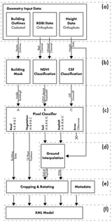
The ongoing climate crisis has highlighted the need for sustainability and resilience in the development and maintenance of urban areas regarding climate comfort. Weather simulation tools can aid researchers in understanding the effects that weather has on the microclimate in urban areas. While simulations are handled autonomously by computers once set up, the creation of the requisite input urban models is still a highly manual process. In this study, a novel method for the automated generation of urban models using land and cadastral remote sensing data is presented. By analyzing grass, trees, buildings, and roads algorithmically, data can be extracted and configured into spatial models compatible with microclimate simulation software such as ENVI-Met. Comparison to a baseline model shows that our method enables the creation of models fit for use for exploring microclimate scenarios in the urban environment, saving time by eliminating the need for manual processing.

14 February 2026

Description of method workflow. The input data (a) is refined and classified (b), the site classifications are constructed (c), missing ground interpolated (d), metadata added, and site model is scaled, cropped, and rotated (e), and written out into output file (f).

Amid the growing convergence of leisure mobility, tourism, and rural development, second homes have emerged as a significant spatial phenomenon reshaping community structures in tourism-oriented rural areas. This study examines how second-home leisure practices contribute to place-making and community identity formation through land-use transformation and everyday spatial experience. Using the Mayangxi Ecotourism Area in Fujian Province, China, as a case study, this study develops a “space–sense of home–place identity” analytical framework grounded in Lefebvre’s theory of the production of space. A mixed-methods design integrating fieldwork, interviews, questionnaire surveys, and structural equation modeling is adopted. The results indicate that perceptions of physical, social, and cultural space significantly enhance second-home users’ sense of home. Physical and social spaces exert strong direct effects on place identity, with social interaction emerging as the most influential factor. Although sense of home positively mediates the relationship between spatial perception and place identity, this mediation is conditional rather than automatic. These findings suggest that second homes should be understood not merely as outcomes of land development, but as negotiated everyday spaces through which land-use transformation, social interaction, and emotional attachment collectively shape community reconstruction in tourism-oriented rural areas.

14 February 2026

Theoretical framework of second-home community identity reconstruction (Source: Drawn by authors).

Landscape Character Assessment (LCA) is increasingly used to support landscape-sensitive planning; however, existing approaches often lack an operational integration of visual perception and map-based indicators, particularly in complex Mediterranean island contexts. This study demonstrates a methodology for integrated landscape character and quality assessment, combining landform and landcover mapping with map-based visibility indicators derived from the local road network. The approach was applied to the Platanos community in western Crete, a representative Mediterranean landscape of contrasting coastal resort zones, agricultural lowlands, and cultural heritage sites. The methodology followed three stages: desk-based mapping of Land Description Units (LDUs) using landform and landcover data, field surveys to define Landscape Character Types (LCTs) and assess socio-cultural and perceptual attributes, and GIS-based visibility analysis from 18 road observation points. Six visual indicators (connectivity, complexity, naturalness, disturbance, historicity, and visual scale) were calculated to quantify spatial and perceptual characteristics. Results revealed a spatial division between a core northern area of high visual scale, cultural importance, but also disturbance, and a southern area of greater naturalness but lower visual openness and cultural visibility. These results highlight that high landscape quality is not solely associated with naturalness, but emerges from the interaction between physical structure, cultural elements, and visual perception. The findings underscore the complementary value of combining physical, cultural, and perception-based metrics in LCA. The proposed framework offers a reproducible tool for evidence-based landscape planning and heritage-sensitive development in accordance with the principles of the European Landscape Convention (ELC).

14 February 2026

The study area. The former local community of Platanos.

This study examines the spatial imbalance and driving mechanisms of human–environment coupling in the Xiuhe River Basin, an important agricultural–ecological watershed in the middle and lower reaches of the Yangtze River. We integrated the coupling-coordination degree (CD) model, Coupling Elasticity Index (CEI), spatial autocorrelation analyses (global and local Moran’s I, LISA, and Getis–Ord Gi*), and GeoDetector to assess spatial heterogeneity, classify coupling types, and identify key human–ecosystem. The results reveal marked spatial variation in coordination levels, which are higher in the central–western mountains and lower in the southeastern plains (global Moran’s I = 0.7344, p < 0.01), indicating significant spatial clustering. Using the CEI, the basin was classified into ecology-dominated zones (ecological advancement with human retreat), human-dominated zones (human advancement with ecological retreat), and relatively balanced zones. Upstream areas (CEI < 0.6) exhibit ecological advantages, whereas downstream plains (CEI > 1.5) experience dominant human pressures. GeoDetector analysis identified population density, proportion of built-up land, and water quality indicators (COD and TP) as the primary drivers, with interactions substantially enhancing explanatory power (e.g., PD × COD q = 0.86). These findings underscore nonlinear feedbacks and cross-scale interactions that influence coordinated ecosystem services in agricultural landscapes. We recommend differentiated management strategies: conserving upstream ecological functions, promoting balanced development in midstream areas, and regulating development intensity and pollution downstream to sustain human–environment coordination. This study provides quantitative evidence and methodological insights to improve understanding of ecological complexity and optimize governance of the agricultural landscape.

14 February 2026

Regional location map. Notes: All maps were produced in the China Geodetic Coordinate System 2000 (CGCS2000), EPSG:4490; the same CRS applies to all other map figures in this manuscript.

News & Conferences

Issues

Open for Submission

Editor's Choice

Reprints of Collections

Resilient Cities and Land Take Effective Management Through Sustainable Urban Planning Tools
Reprint

Resilient Cities and Land Take Effective Management Through Sustainable Urban Planning Tools

Editors: Debora Anelli, Pierluigi Morano, Marco Locurcio, Francesco Tajani
Land Use/Land Cover and Natural Hazards
Reprint

Land Use/Land Cover and Natural Hazards

Interactions, Changes, and Impacts, 2nd Edition
Editors: Matej Vojtek, Andrea Petroselli, Raffaele Pelorosso

Get Alerted

Add your email address to receive forthcoming issues of this journal.

XFacebookLinkedIn
Land - ISSN 2073-445X