Habitat Suitability Evaluation of Different Forest Species in Lvliang Mountain by Combining Prior Knowledge and MaxEnt Model

 and
and
Abstract
:1. Introduction
2. Materials and Methods
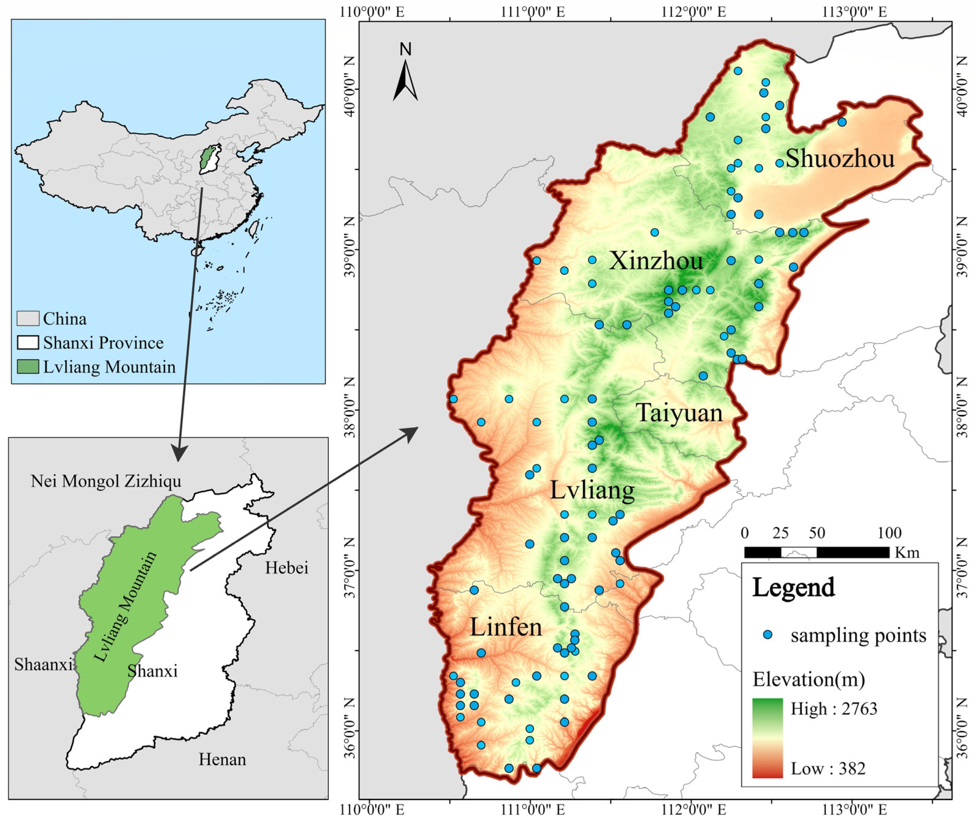
2.1. Study Area
2.2. Data Collection and Preprocessing
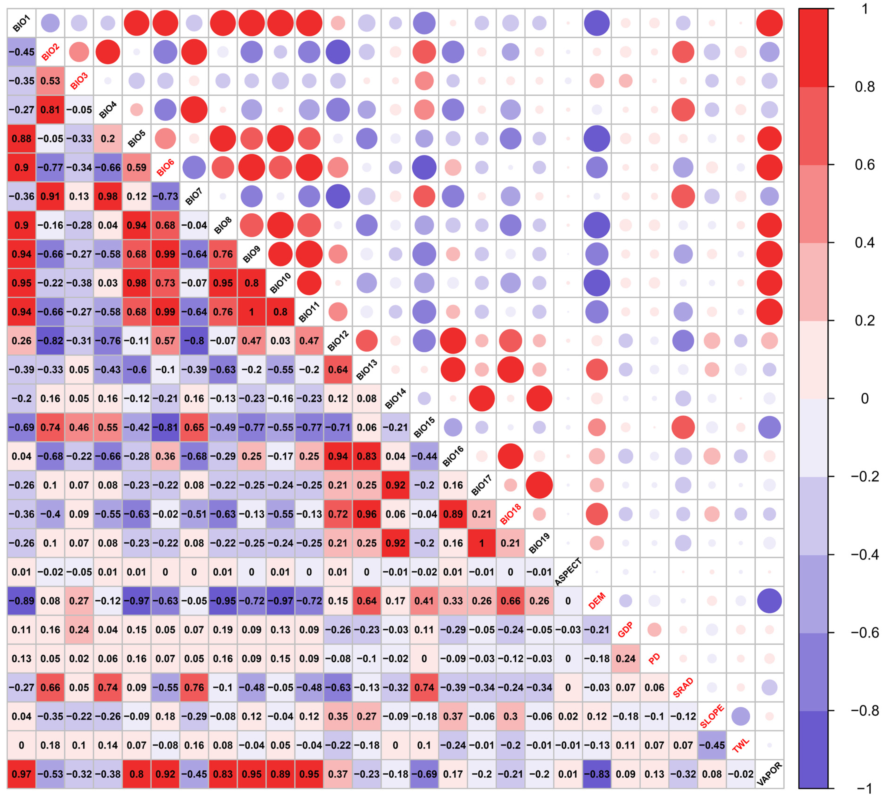
2.3. Environmental Variables
2.4. Model Construction and Evaluation
3. Results
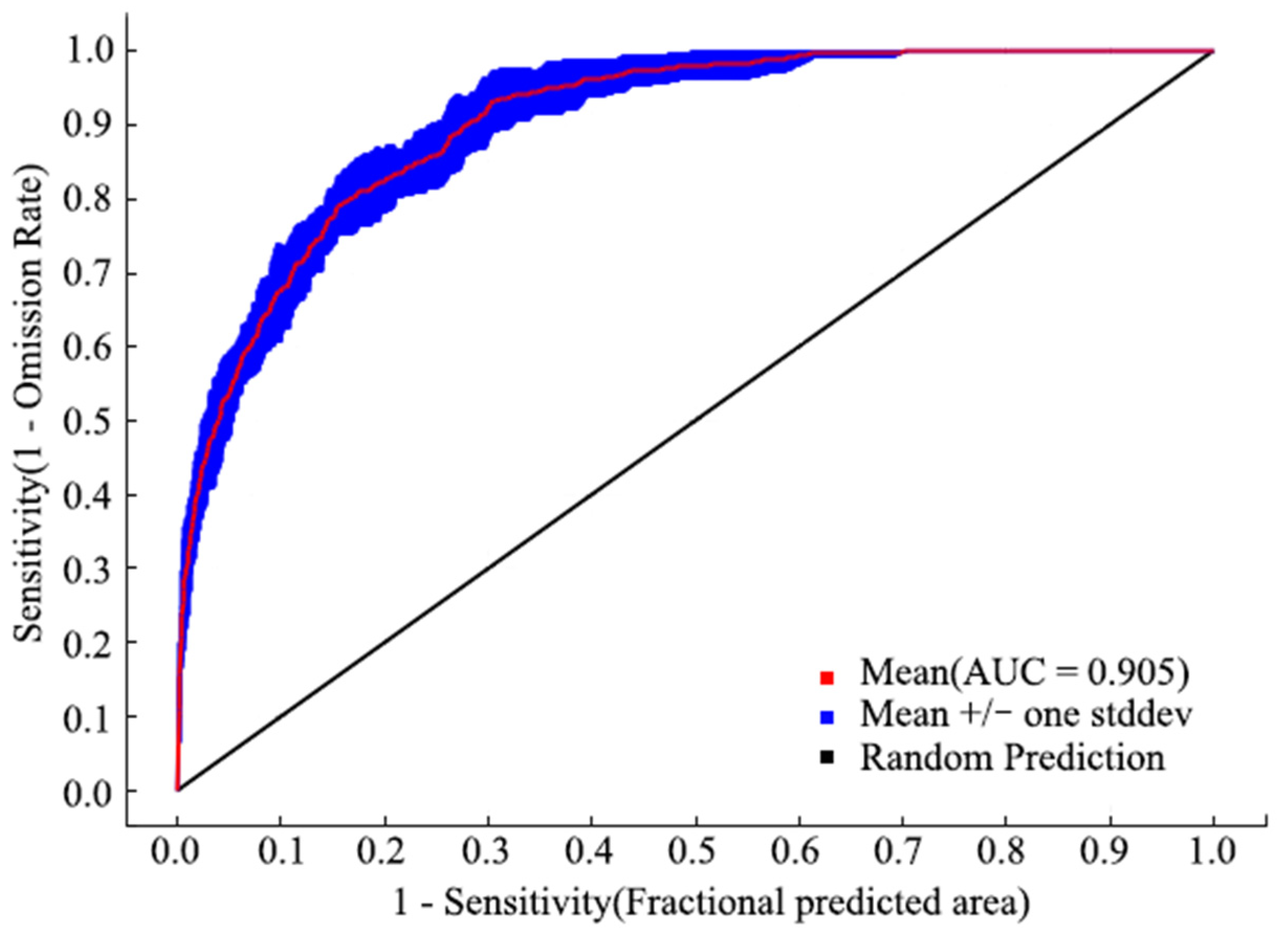
3.1. Model Accuracy
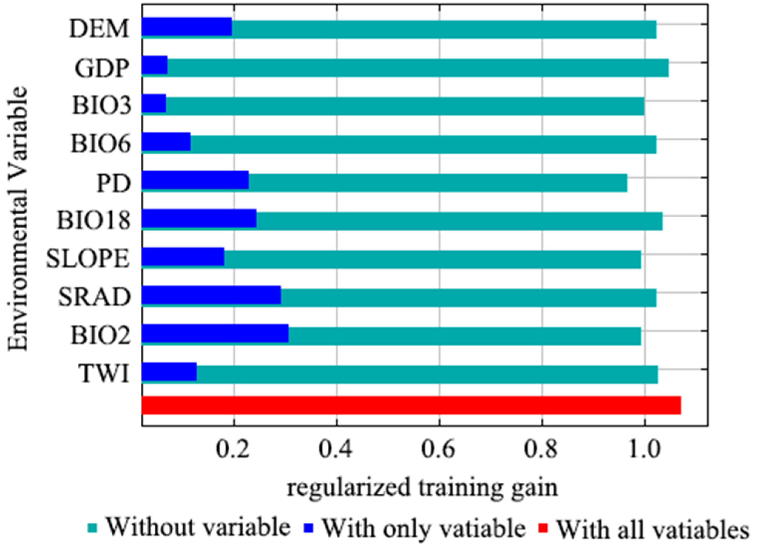
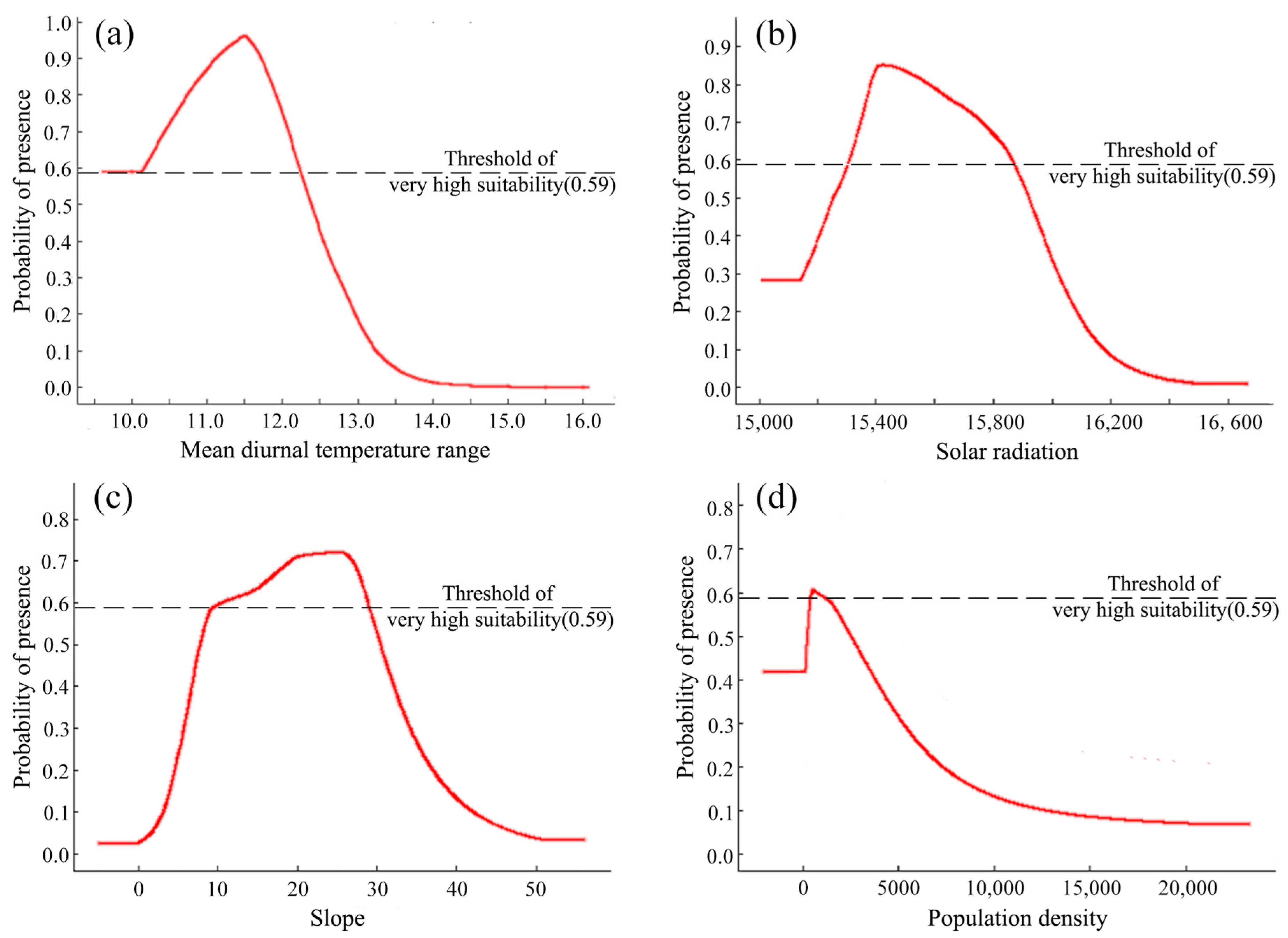
3.2. Identified Main Environmental Factors
3.3. Suitable Habitats for Forest in Lvliang Mountain
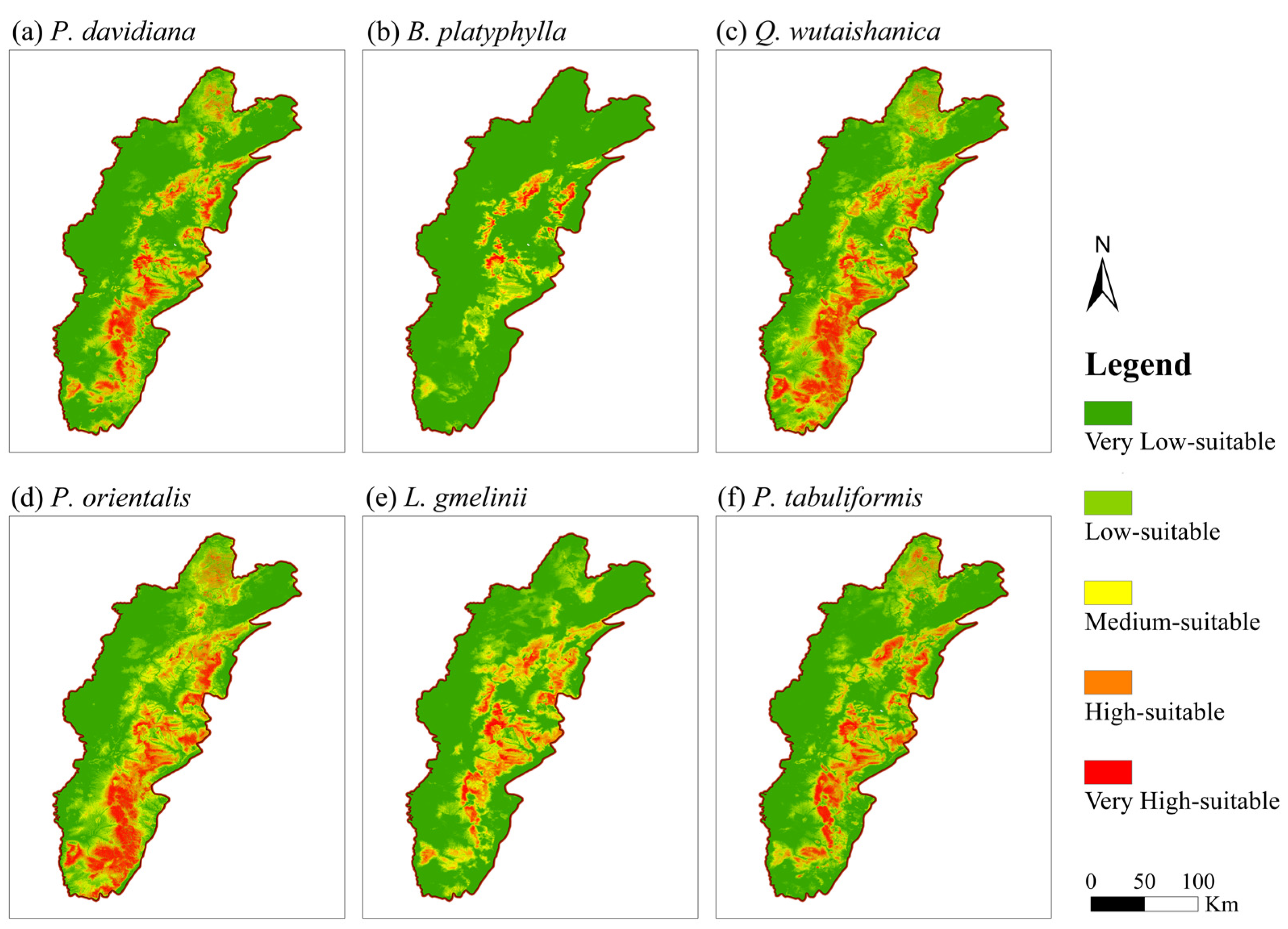
3.4. Suitable Habitats for Different Forest Species in Lvliang Mountain
4. Discussion
5. Conclusions
Author Contributions
Funding
Institutional Review Board Statement
Informed Consent Statement
Data Availability Statement
Conflicts of Interest
References
- Dixon, R.K.; Wisniewski, J. Global forest systems: An uncertain response to atmospheric pollutants and global climate change? Water Air Soil Pollut. 1995, 85, 101–110. [Google Scholar] [CrossRef]
- Dixon, R.K.; Solomon, A.M.; Brown, S.; Houghton, R.A.; Trexier, M.C.; Wisniewski, J. Carbon pools and flux of global forest ecosystems. Science 1994, 263, 185–190. [Google Scholar] [CrossRef] [PubMed]
- Lal, R. Soil carbon sequestration to mitigate climate change. Geoderma 2004, 123, 1–22. [Google Scholar] [CrossRef]
- Xu, X.F.; Tian, H.Q.; Wan, S.Q. Climate warming impacts on carbon cycling in terrestrial ecosystems. Chin. J. Plant Ecol. 2007, 31, 175–188. [Google Scholar]
- Vessella, F.; Schirone, B. Predicting potential distribution of Quercus suber in Italy based on ecological niche models: Conservation insights and reforestation involvements. For. Ecol. Manag. 2013, 304, 150–161. [Google Scholar] [CrossRef]
- Richter, D.D.; Markewitz, D.; Trumbore, S.E.; Wells, C.G. Rapid accumulation and turnover of soil carbon in a re-establishing forest. Nature 1999, 400, 56–58. [Google Scholar] [CrossRef] [Green Version]
- Li, Y.Q.; He, C.X. Research progress of natural resource utilization in agroforestry system in China. Sci. Silvae Sin. 2014, 50, 141–145. [Google Scholar]
- Chen, X.Q.; Zhang, X.Q.; Zhang, Y.P.; Wan, C.B. Carbon sequestration potential of the stands under the Grain for Green Program in Yunnan Province, China. For. Ecol. Manag. 2009, 258, 199–206. [Google Scholar] [CrossRef]
- Wang, Y.L. Review on china’s plantation development since the reform and opening up. For. Resour. Manag. 2019, 0, 6–11. [Google Scholar]
- Hou, Q.C.; Han, R.L. Problems on vegetation construction in loess plateau region. Bull. Soil Water Conserv. 2000, 20, 53–56. [Google Scholar]
- Dettki, H.; Löfstrand, R.; Edenius, L. Modeling habitat suitability for moose in coastal northern sweden: Empirical vs process-oriented approaches. Ambio 2003, 32, 549–556. [Google Scholar] [CrossRef] [PubMed]
- Estes, L.D.; Bradley, B.A.; Beukesv, H.; Hole, D.G.; Lau, M.; Oppenheimerv, M.G.; Schulze, R.; Tadrossv, M.A.; Turner, W.R. Comparing mechanistic and empirical model projections of crop suitability and productivity: Implications for ecological forecasting. Glob. Ecol. Biogeogr. 2013, 22, 1007–1018. [Google Scholar] [CrossRef]
- Li, H.M.; Han, H.X.; Xue, D.Y. Prediction of potential geographic distribution areas for the pine bark scale, Matsucoccus matsumurae (Kuwana) (Homoptera: Margarodidae) in China using GARP modelling system. Acta Entomol. Sin. 2005, 48, 95–100. [Google Scholar]
- Phillips, S.J.; Dudík, M.; Schapire, R.E. A maximum entropy approach to species distribution modeling. In Proceedings of the Twenty First International Conference on Machine Learning, Banff, AB, Canada, 4–8 July 2004. [Google Scholar]
- Ray, N.; Burgman, M.A. Subjective uncertainties in habitat suitability maps. Ecol. Model. 2006, 195, 172–186. [Google Scholar] [CrossRef]
- Lehmann, A.; Overton, J.M.; Leathwick, J.R. GRASP: Generalized regression analysis and spatial prediction. Ecol. Model. 2002, 160, 165–183. [Google Scholar] [CrossRef]
- O’Hanley, J.R. NeuralEnsembles: A neural network based ensemble forecasting program for habitat and bioclimatic suitability analysis. Ecography 2009, 32, 89–93. [Google Scholar] [CrossRef]
- Tantipisanuh, N.; Gale, G.A.; Pollino, C. Bayesian networks for habitat suitability modeling: A potential tool for conservation planning with scarce resources. Ecol Appl. 2014, 24, 1705–1718. [Google Scholar] [CrossRef]
- Bai, J.J.; Hou, P.; Zhao, Y.H.; Xu, H.T.; Zhang, B. The research progress of species habitat suitability models and verification. Chin. J. Ecol. 2022, 41, 1423–1432. [Google Scholar]
- Tsoar, A.; Allouche, O.; Steinitz, O.; Rotem, D.; Kadmon, R. A comparative evaluation of presence-only methods for modelling species distribution. Divers. Distrib. 2007, 13, 397–405. [Google Scholar] [CrossRef]
- Olden, J.D.; Lawler, J.J.; Poff, N.L. Machine learning methods without tears: A primer for ecologists. Q. Rev. Biol. 2008, 83, 171–193. [Google Scholar] [CrossRef] [Green Version]
- Qiao, H.J.; Hu, J.H.; Huang, J.H. Theoretical basis, future directions, and challenges for ecological niche models. Sci. Sin. (Vitae) 2013, 43, 915–927. [Google Scholar] [CrossRef]
- Elith, J.; Leathwick, J.R. Species distribution models: Ecological explanation and prediction acrossspace and time. Annu. Rev. Ecol. Evol. Syst. 2009, 40, 677–697. [Google Scholar] [CrossRef]
- Phillips, S.J.; Anderson, R.P.; Schapire, R.E. Maximum entropy modeling of species geographic distributions. Ecol. Model. 2006, 190, 231–259. [Google Scholar] [CrossRef] [Green Version]
- Chu, J.M.; Li, Y.F.; Zhang, L.; Li, B.; Gao, M.Y.; Tang, X.Q.; Ni, J.W.; Xu, X.Q. Potential distribution range and conservation strategies for the endangered species Amygdalus pedunculata. Biodivers. Sci. 2017, 25, 799–806. [Google Scholar] [CrossRef] [Green Version]
- Feeley, K.J.; Silman, M.R. Keep collecting: Accurate species distribution modelling requires more collections than previously thought. Divers. Distrib. 2011, 17, 132–1140. [Google Scholar] [CrossRef]
- Muscarella, R.; Galante, P.J.; Soley-Guardia, M.; Boria, R.A.; Kass, J.M.; Uriarte, M.; Anderson, R.P.; Mcpherson, J. ENMeval: An R package for conducting spatially independent evaluations and estimating optimal model complexity for Maxent ecological niche models. Methods Ecol. Evol. 2014, 5, 1198–1205. [Google Scholar] [CrossRef] [Green Version]
- An, Y.; Yang, L.; Zhu, A.X.; Qin, C.; Shi, J. Identification of representative samples from existing samples for digital soil mapping. Geoderma 2018, 311, 109–119. [Google Scholar] [CrossRef]
- Wulder, M.A.; Nelson, T.A.; Seemann, D. Using spatial pattern to quantify relationship between samples, surroundings, and populations. Env. Monit. Assess. 2007, 131, 221–230. [Google Scholar] [CrossRef]
- Li, Q.; Guo, F.Z. Forestry Ecological Construction in Ecologically Vulnerable Area of Shanxi Province; China Forestry Publishing House: Beijing, China, 2010. [Google Scholar]
- Hou, Y.K.; Duan, S.G.; Zhang, S. Major Tree Species for Conversion of Cropland to Forest in China; China Agriculture Press: Beijing, China, 2004; pp. 53–79. [Google Scholar]
- Liu, S.E. Atlas of Woody Plants of Northeast China; Science Press: Beijing, China, 1955. [Google Scholar]
- Wang, S.; Zhou, C.; Li, K.; Zhu, S.; Huang, F. Analysis on spatial distribution characteristics of soil organic carbon reservoir in China. Acta Geogr. Sin. 2000, 55, 533–544. [Google Scholar]
- Wang, N.; Fu, F.Z. Study on Carbon Stock in the Forest Ecosystem of Shanxi; China Agricultural Science and Technology Press: Beijing, China, 2015; pp. 61–79. [Google Scholar]
- Hengl, T.; Mendes de Jesus, J.; Heuvelink, G.B.; Ruiperez Gonzalez, M.; Kilibarda, M.; Blagotic, A.; Shangguan, W.; Wright, M.N.; Geng, X.; Bauer-Marschallinger, B.; et al. SoilGrids250m: Global gridded soil information based on machine learning. PLoS ONE 2017, 12, e0169748. [Google Scholar] [CrossRef] [Green Version]
- Fick, S.E.; Hijmans, R.J. WorldClim 2: New 1-km spatial resolution climate surfaces for global land areas. Int. J. Climatol. 2017, 37, 4302–4315. [Google Scholar] [CrossRef]
- Amaral, L.A.N.; Stevens, F.R.; Gaughan, A.E.; Linard, C.; Tatem, A.J. Disaggregating census data for population mapping using random forests with remotely-sensed and ancillary data. PLoS ONE 2015, 10, e0107042. [Google Scholar]
- The Statistics Bureau of Shanxi Province Releases Data: Statistical Yearbook of Shanxi Province in 2007. Available online: http://tjj.shanxi.gov.cn/tjsj/tjnj/nj2008/html/njcx.htm (accessed on 20 January 2023).
- Swanepoel, L.H.; Lindsey, P.; Somers, M.J.; van Hoven, W.; Dalerum, F.; Pettorelli, N.; Penteriani, V. Extent and fragmentation of suitable leopard habitat in South Africa. Anim. Conserv. 2013, 16, 41–50. [Google Scholar] [CrossRef] [Green Version]
- Warren, D.L.; Glor, R.E.; Turelli, M. ENMTools: A toolbox for comparative studies of environmental niche models. Ecography 2010, 33, 607–611. [Google Scholar] [CrossRef]
- Merow, C.; Smith, M.; Silander, J.A. A practical guide to Maxent: What it does, and why inputs and settings matter. Ecography 2013, 36, 1–12. [Google Scholar] [CrossRef]
- Jin, L.R.; Sun, K.P.; He, H.S.; Zhou, Y.F. Research advances in habitat suitability index model. Chin. J. Ecol. 2008, 27, 841–846. [Google Scholar]
- Huang, Z.H.; Zhou, X.; Zhang, X.R.; Pu, Z.; Xing, S.H. Suitability assessments of potential distribution areas for Amur corktree in mainland China. Acta Ecol. Sin. 2018, 38, 7469–7476. [Google Scholar]
- Yu, J.; Fu, M.X.; Song, X.Q.; Gao, F.; Yang, B.; Li, S.Q. MaxEnt modeling-based habitat suitability assessment of Macaca thibetana in Daxiangling Nature Reserve, Sichuan province. J. Sichuan For. Sci. Technol. 2020, 41, 45–50. [Google Scholar]
- Lobo, J.M.; Jiménez-Valverde, A.; Real, R. AUC: A misleading measure of the performance of predictive distribution models. Glob. Ecol. Biogeogr. 2008, 17, 145–151. [Google Scholar] [CrossRef]
- Wang, Y.S.; Xie, B.Y.; Wan, F.H.; Xiao, Q.M.; Dai, L.Y. Application of ROC curve analysis in evaluating the performance of alien species’ potential distribution models. Biodivers. Sci. 2007, 15, 365–372. [Google Scholar]
- Salako, V.K.; Vihotogbé, R.; Houéhanou, T.; Sodé, I.A.; Glèlè Kakaï, R. Predicting the potential impact of climate change on the declining agroforestry species Borassus aethiopum Mart. in Benin: A mixture of geostatistical and SDM approach. Agrofor. Syst. 2018, 93, 1513–1530. [Google Scholar] [CrossRef]
- Creley, C.M.; Shilling, F.M.; Muchlinski, A.E. An ecological niche model to predict range expansion of the eastern gray squirrel in california. Bull. South. Calif. Acad. Sci. 2019, 118, 58–70. [Google Scholar] [CrossRef] [Green Version]
- Jenks, G.F. The data model concept in statistical mapping. Int. Yearb. Cartogr. 1967, 7, 186–190. [Google Scholar]
- Mu, X.Y.; Wu, Z.Y.; Li, X.Y.; Wang, F.; Bai, X.X.; Guo, S.W.; Cheng, R.C.; Yu, S.L. Estimation of the potential distribution areas of Larix principis-rupprechtii plantation in Chifeng based on MaxEnt model. J. Arid Land Resour. Environ. 2021, 35, 144–152. [Google Scholar]
- Wang, Q.; Fan, B.G.; Zhao, G.H. Prediction of potential distribution area of Corylus mandshurica in China under climate change. Chin. J. Ecol. 2020, 39, 3774–3784. [Google Scholar]
- Li, X.; Li, Y.; Fang, Y.M. Prediction of potential suitable distribution areas of Quercus fabri in China based on an optimized Maxent model. Sci. Silvae Sin. 2018, 54, 153–164. [Google Scholar]
- Guo, Y.L.; Zhao, Z.F.; Zhu, F.X.; Li, X. Climate change may cause distribution area loss for tree species in southern China. For. Ecol. Manag. 2022, 511, 120134. [Google Scholar] [CrossRef]
- Li, L.; Zhou, F.; Tian, J.; Wang, X.J. Effects of topographic factors on soil organic carbon content in semiarid regions. North. Hortic. 2019, 1, 104–109. [Google Scholar]
- Zhao, R.B. Study on Soil Organic Carbon Content of the Second Phase of Forestry Project in Sandification Combating Program for Area in Vicinty of Beijing. Master’s Thesis, Beijing Forestry University, Beijing, China, 2020. [Google Scholar]
- Notice of the National Forestry and Grassland Administration on Printing and Distributing the Measures for the New Round of Inspection and Acceptance for Returning Farmland to Forest Projects. Available online: https://www.forestry.gov.cn/main/5925/20200414/090421676754954.html (accessed on 8 October 2022).
- Yu, Z.Y.; Yang, Y.S.; Chen, G.S. Changes of carbon storage and carbon sequestration in plantation ecosystems on purple soil. Chin. J. Appl. Ecol. 2004, 15, 1837–1841. [Google Scholar]
- Xu, X.L.; Cao, M.K.; Li, K.R. Temporal-spatial dynamics of carbon storage of forest vegetation in China. Prog. Geogr. 2007, 26, 1–10. [Google Scholar]
- Ye, L.Y. The Study of Forest Organic Carbon Spatial Varition and Impact Factors in Zhejiang Province. Master’s Thesis, Zhejiang Agriculture and Forest University, Zhejiang, China, 2012. [Google Scholar]
- Wang, F.; Xiong, Z.; Yan, X.D.; Dai, X.G.; Wang, L.B.; Li, Y.F. Geographical distribution pattern of species diversity of the genus Populus L. in China. Acta Ecol. Sin. 2018, 38, 282–290. [Google Scholar]
- Tian, Y.M. Study on the physiological and ecological characteristics of several plants in the Taihang Mountains. J. Hebei Univ. (Nat. Sci. Ed.) 1987, 2, 45–50. [Google Scholar]
- Cheng, R.; Wang, X.; Zhang, J.; Zhao, J.; Ge, Z.; Zhang, Z. Predicting the potential suitable distribution of Larix principis-rupprechtii Mayr under climate change scenarios. Forests 2022, 13, 1428. [Google Scholar] [CrossRef]
- Wang, Y. Carbon Density and Spatial Distribution Pattern of Forest Ecosystem in the Lüliang Mountains, China. Doctoral Thesis, Shanxi University, Taiyuan, China, 2019. [Google Scholar]
- The Results of the Eighth National Forest Resources Inventory (2009–2013). Available online: https://www.forestry.gov.cn/main/65/20140225/659670.html (accessed on 8 October 2018).
- Wang, M.B. Study on the Integrated Management Planning for the Loess Plateau Region: Shanxi Province; China Forestry Publishing House: Beijing, China, 2009. [Google Scholar]
- Tian, G.Q.; Kuang, L.G.; Zhu, S.Z. Forest Site Classification and Afforestation Modes in Shanxi Province; China Forestry Publishing House: Beijing, China, 2010. [Google Scholar]


| Soil Layer | Weight | Organic Carbon Content of Different Forest Species (g/kg) | |||||
|---|---|---|---|---|---|---|---|
| Populus davidiana | Betula platyphylla | Quercus wutaishanica | Platycladus orientalis | Larix gmelinii | Pinus tabuliformis | ||
| ①: 0–10 cm | 0.2 | 18.34 | 35.09 | 12.09 | 14.07 | 31.02 | 14.86 |
| ②: 10–20 cm | 0.2 | 5.13 | 16.81 | 5.95 | 2.54 | 11.13 | 7.93 |
| ③: 20–30 cm | 0.2 | 3.28 | 11.8 | 3.22 | 1.34 | 5.02 | 4.35 |
| ④: 30–50 cm | 0.4 | 2.94 | 7.82 | 1.85 | 4.08 | 5.68 | 5.18 |
| 0–50 cm | 0.2 × ① + 0.2 × ② + 0.2 × ③ + 0.4 × ④ | 6.53 | 15.87 | 4.99 | 5.22 | 11.71 | 7.50 |
| Variable | Description | Type |
|---|---|---|
| BIO1 | Annual mean air temperature/°C | Climatic |
| BIO2 | Mean diurnal temperature range/°C | Climatic |
| BIO3 | Isothermality/°C | Climatic |
| BIO4 | Temperature seasonality | Climatic |
| BIO5 | Maximum temperature of warmest month | Climatic |
| BIO6 | Min Temperature of Coldest Month/°C | Climatic |
| BIO7 | Temperature annual range/°C | Climatic |
| BIO8 | Mean temperature of wettest quarter/°C | Climatic |
| BIO9 | Mean temperature of driest quarter/°C | Climatic |
| BIO10 | Mean temperature of warmest quarter/°C | Climatic |
| BIO11 | Mean temperature of coldest quarter/°C | Climatic |
| BIO12 | Annual precipitation/mm | Climatic |
| BIO13 | Precipitation of wettest month/mm | Climatic |
| BIO14 | Precipitation of driest month/mm | Climatic |
| BIO15 | Precipitation seasonality | Climatic |
| BIO16 | Precipitation of wettest quarter/mm | Climatic |
| BIO17 | Precipitation of driest quarter/mm | Climatic |
| BIO18 | Precipitation of Warmest Quarter/mm | Climatic |
| BIO19 | Precipitation of coldest quarter/mm | Climatic |
| VAPOR | water vapor pressure/Pa | Climatic |
| SRAD | Solar radiation/(W/m2) | Climatic |
| DEM | Elevation/m | Topographic |
| ASPECT | Aspect | Topographic |
| SLOPE | Slope/° | Topographic |
| PD | Population density | Social |
| TWI | Topographic wetness index | Topographic |
| GDP | Per Capita GDP/(yuan/person) | Social |
| Variable | Description | Type | Contribution |
|---|---|---|---|
| BIO2 | Mean diurnal temperature range | Climatic | 18.4% |
| SRAD | Solar radiation | Climatic | 16.2% |
| PD | Population density | Social | 14.8% |
| SLOPE | Slope | Topographic | 14.3% |
| BIO18 | Aspect | Climatic | 9.4% |
| DEM | Elevation | Topographic | 7.3% |
| BIO3 | Isothermality | Climatic | 6.9% |
| GDP | Per Capita GDP | Social | 4.7% |
| BIO6 | Precipitation of wettest quarter | Climatic | 4.1% |
| TWI | Topographic wetness index | Topographic | 3.9% |
Disclaimer/Publisher’s Note: The statements, opinions and data contained in all publications are solely those of the individual author(s) and contributor(s) and not of MDPI and/or the editor(s). MDPI and/or the editor(s) disclaim responsibility for any injury to people or property resulting from any ideas, methods, instructions or products referred to in the content. |
© 2023 by the authors. Licensee MDPI, Basel, Switzerland. This article is an open access article distributed under the terms and conditions of the Creative Commons Attribution (CC BY) license (https://creativecommons.org/licenses/by/4.0/).
Share and Cite
Zhao, X.; Zheng, Y.; Wang, W.; Wang, Z.; Zhang, Q.; Liu, J.; Zhang, C. Habitat Suitability Evaluation of Different Forest Species in Lvliang Mountain by Combining Prior Knowledge and MaxEnt Model. Forests 2023, 14, 438. https://doi.org/10.3390/f14020438
Zhao X, Zheng Y, Wang W, Wang Z, Zhang Q, Liu J, Zhang C. Habitat Suitability Evaluation of Different Forest Species in Lvliang Mountain by Combining Prior Knowledge and MaxEnt Model. Forests. 2023; 14(2):438. https://doi.org/10.3390/f14020438
Chicago/Turabian StyleZhao, Xiaonan, Yutong Zheng, Wei Wang, Zhao Wang, Qingfeng Zhang, Jincheng Liu, and Chutian Zhang. 2023. "Habitat Suitability Evaluation of Different Forest Species in Lvliang Mountain by Combining Prior Knowledge and MaxEnt Model" Forests 14, no. 2: 438. https://doi.org/10.3390/f14020438