Article

Recovery of Vegetation Cover and Soil after the Removal of Sheep in Socorro Island, Mexico

by
Antonio Ortíz-Alcaraz
1,2,
Yolanda Maya-Delgado
1,*,
Patricia Cortés-Calva
1,
Alfonso Aguirre-Muñoz
2,
Evaristo Rojas-Mayoral
2,
Miguel V. Cordoba-Matson
1 and
Alfredo Ortega-Rubio
1
1
Centro de Investigaciones Biológicas del Noroeste, S.C. Av. Instituto Politécnico Nacional 195, La Paz, B.C.S. 23096, Mexico
2
Grupo de Ecología y Conservación de Islas, A.C. Moctezuma 836, Ensenada, B.C., 22800, Mexico
*
Author to whom correspondence should be addressed.
Forests 2016, 7(4), 91; https://doi.org/10.3390/f7040091
Submission received: 4 February 2016 / Revised: 20 April 2016 / Accepted: 20 April 2016 / Published: 22 April 2016

Abstract

:
For over 140 years, the habitat of Socorro Island in the Mexican Pacific has been altered by the presence of exotic sheep. Overgrazing, jointly with tropical storms, has caused soil erosion, and more than 2000 hectares of native vegetation have been lost. Sheep eradication was conducted from 2009 to 2012. Since then, the vegetation has begun to recover passively, modifying soil properties. The objective of our study was to verify that this island was resilient enough to be recovered and in a relatively short time scale. To confirm our hypothesis, we analyzed changes in the physical-chemical properties of the soil and vegetation cover, the last one in different times and habitats after sheep eradication. The change in vegetation cover was estimated by comparing the normalized difference vegetation index (NDVI) between 2008 and 2013. In sites altered by feral sheep, soil compaction was assessed, and soil samples were taken, analyzing pH, electrical conductivity, organic carbon, total nitrogen, phosphorus, calcium, and magnesium. After a year of total sheep eradication, clear indications in the recovery of vegetation cover and improvement of soil quality parameters were observed and confirmed, specifically compaction and nitrogen, organic carbon, phosphorus, and calcium. The results seem to support our hypothesis.

1. Introduction

Habitat degradation caused by feral herbivores is one of the most serious ecological problems seen in island ecosystems worldwide [1,2,3,4,5,6,7,8,9,10,11,12,13,14]. Invasive exotic herbivores often have evolutionary strategies that favor their adaptation to the insular environment [15] and usually have negative effects on native plants and animal species, including soil erosion and compaction, vegetation cover loss, competition with native herbivores, and extirpation and extinction of endemic species [8,16,17,18].
Islands have higher concentrations of endemic species than the mainland; the proportion of endemics increases with isolation, island size, and topography. These centers of endemism are frequently threatened by human activity [19,20,21]. In 1869, 100 sheep (Ovis aries Linnaeus, 1758) from Australia were introduced to Socorro Island in the Revillagigedo Archipelago. They became feral and adapted to the insular environment [22]. In the absence of natural enemies, sheep population grew to be about 5000 individuals in 1960 [23], ca. 2000 in 1988 as a result of increased hunting effort by the Mexican Navy [24], and they became the main disturbance agent of the island’s ecological conditions [25,26]. Sheep are credited with the loss of soil and vegetation cover in 30% of the island surface [27,28], habitat quality deterioration, and population decline of endemic vertebrates [24,29,30,31].
The island has different erosion degrees by removing vegetation cover due to overgrazing, which, in addition to sheep bed sites and rest areas, produced soil compaction, removal of the litter layer, and destruction of seedlings [24,32]. The erosion was exacerbated due to the geographical position of the island, located in the path of hurricanes in the Pacific, causing torrential rains with a consequent eroded soil landslide. Because runoff and erosion rates increase in an inverse relationship with plant cover [33], water was mobilized in large runoff through the bare areas and concentrated in natural hollows or in the trails used by the sheep to move from one grazing area to another, resulting in deep erosion gullies. Its formation was favored by the soil texture since the island’s eroded areas are characterized by a high percentage of clay.
Some ecosystems may be sufficiently resilient to recover if the degree of damage has not reached the ecological irreversible threshold [34]. Other possible scenarios are limited recovery, unintended consequences [35], or that it may take long geological time scales [36]. The degree of recovery will depend on the magnitude and duration of impacts, as well as on the nature of the disturbed ecosystem [37]. Our hypothesis was that Socorro Island is resilient enough to recover in a relatively small time scale, after the removal of the pressures caused by a large exotic herbivore. Thus, the objectives of this study were to (1) perform a temporal analysis of the normalized difference vegetation index (NDVI) in images taken in 2008 and 2013; (2) assess the changes in vegetation cover and the number of plant species in different habitats of the island by field sampling; (3) identify pioneer species in eroded soils; and (4) evaluate the physical and chemical properties of soil under the different percentages of plant cover that derived from the elimination of the main source of disturbance.

2. Materials and Methods

2.1. Study Area

The Socorro Island is a tropical volcanic island located in the Revillagigedo Archipelago (18°42’28” N, 111°02’49” W), east of the Pacific Ocean (Figure 1). It has an area of 132 km2 and a maximum elevation of 1040 m. It is located in the path of tropical cyclones that occur from June to November with an average of 2.75 events per year, with precipitation of more than 400 mm during the season [38]. There are no freshwater streams, and approximately 27% of 117 vascular plant species are endemic to the island [39]. Except for the disturbed areas, a dense deciduous and evergreen tropical scrub with patches of low tropical forest covers Socorro Island. Deciduous trees are dominant in the lowlands, with endemic evergreens in the higher parts of the island. On the southern slopes (500–800 m), more woodland is observed than on the steeper northern side of Socorro due to deeper soils and flatter terrain [24,40,41]. No records of native herbivore mammals are available [42].
Since their introduction, sheep had become feral and the population varied from 2000 to 5000 individuals [22,23,24]. Sheep were mainly concentrated in the central-southern portion of Socorro Island. The dense and tangled island scrub, as well as a dangerously sharp and brittle surface of several high-ridged rocky lava flows and a scarcity of freshwater sources, appeared to be the reason why they did not disperse and impact the northern portion of the island [24]. The sheep caused erosion on much of the central-southern portion of the island [24,32], particularly in the areas corresponding to the guayabillo (Psidium socorrense I.M.Johnst.) scrub. The eroded surfaces were transformed in savannah-like and prairie-like open spaces, with a mix of native and exotic vegetation [24] besides a small number of individuals and species [39] with a consequent reduction in vegetation cover. As a conservation measurement of natural resources in Mexico and particularly in Socorro Island, several Mexican agencies started eradication programs of feral sheep in 2008 ending in 2012. Along this study, sheep population decreased drastically due to eradication campaigns. Aerial sightings have recorded an estimation of 1800 individuals in 2009, 500 in 2010, and 100 in 2011 [43], which have been eradicated by 2012. Since then, passive vegetation recovery has been documented.
From an edaphological point of view, Socorro Island has three areas: (1) The northern area has thin soils overlying recent lava, and pyroclastic spills dominate the soils most recently formed on the island; it has dense vegetation that does not require deep soil to thrive; (2) The central area has soils deriving from volcanic glass, which cover older soils and rocks. Toward its southern region, clay and red and deep soils have formed from basalt with a high iron content that provides the characteristic red color of the island landscapes [32]; (3) The central-southern portion of the island, the most clearly eroded and denuded, was our sampling area.

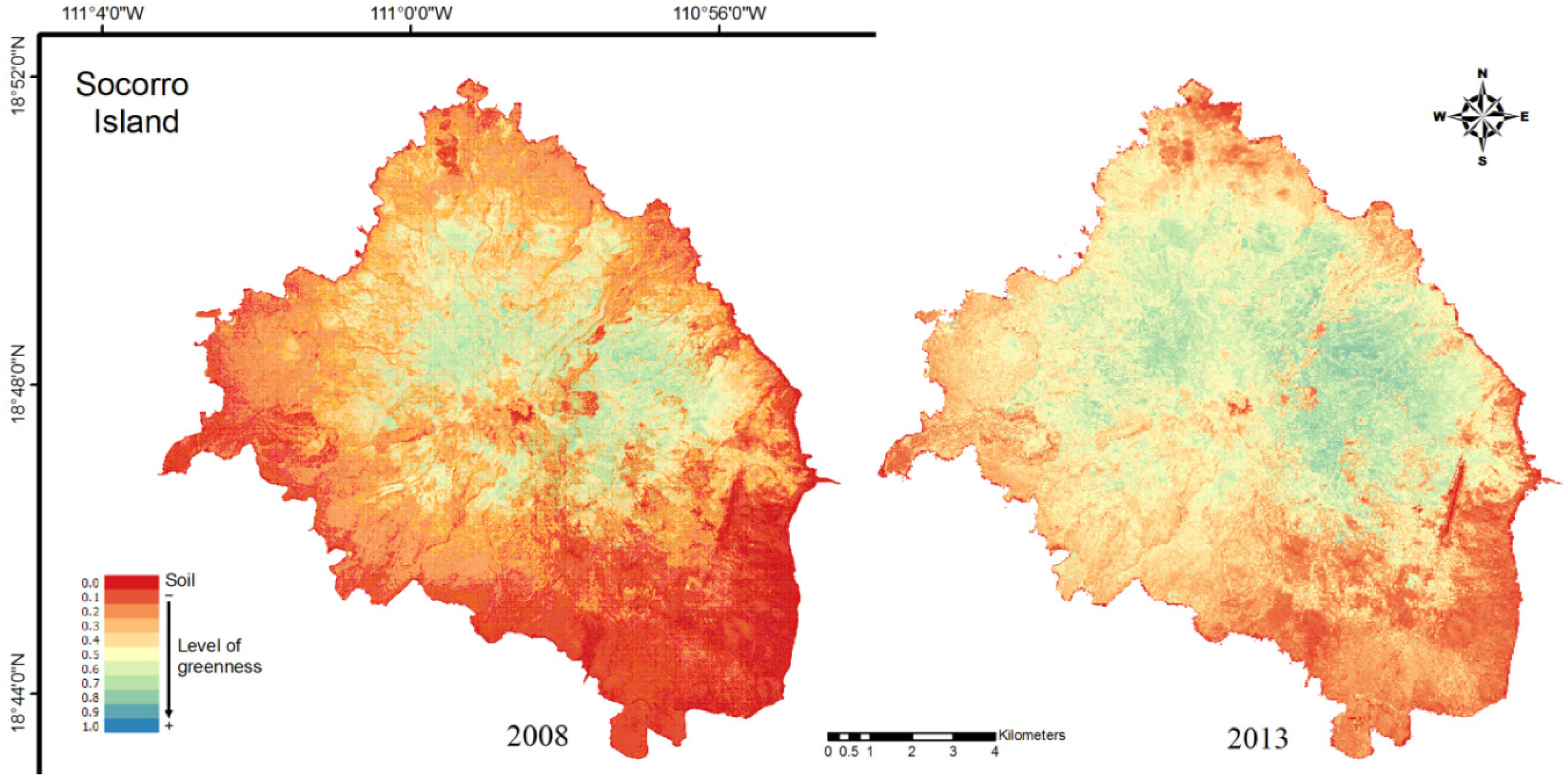
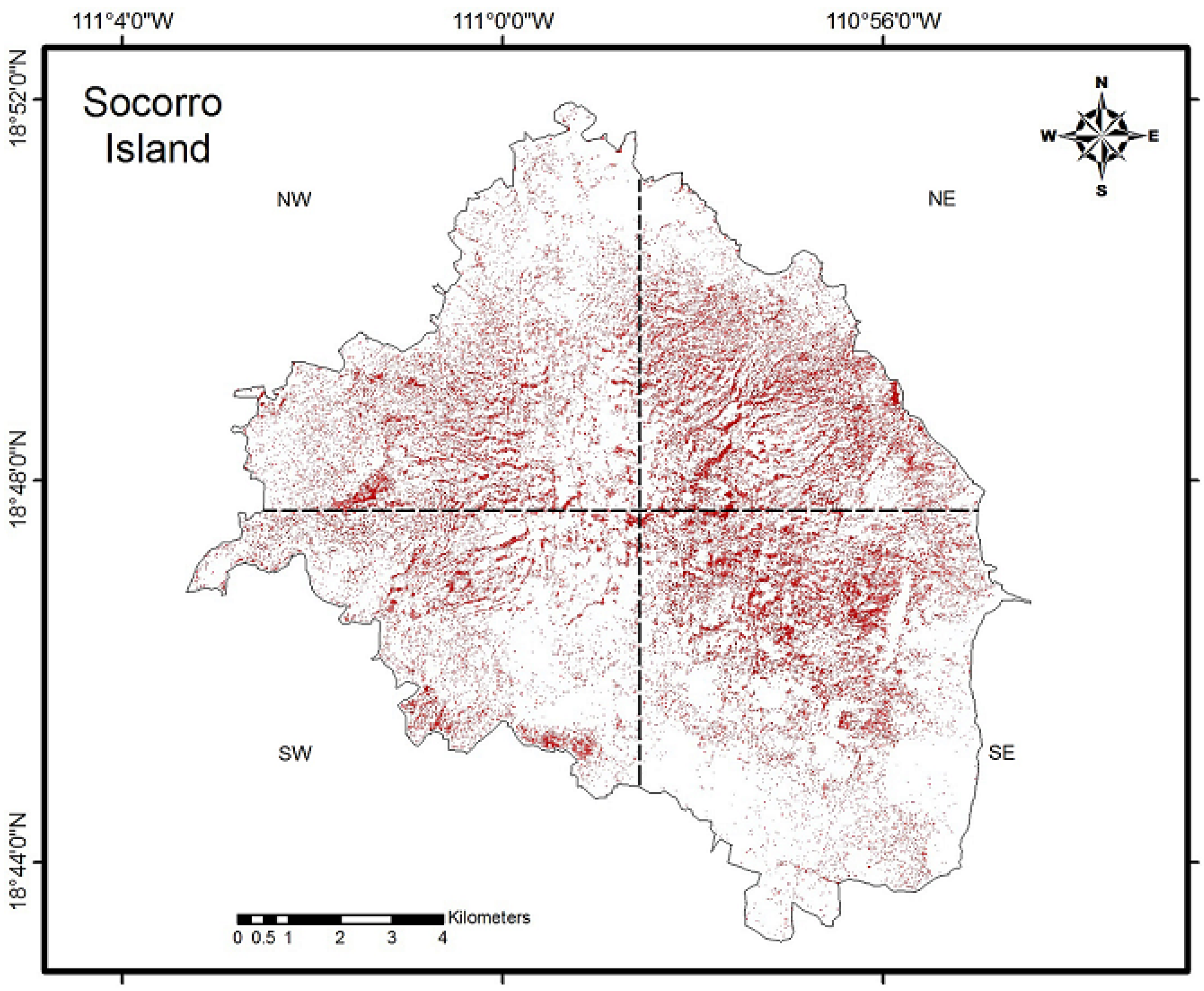
2.2. Normalized Difference Vegetation Index (NDVI)

To assess the changes in vegetation cover, we evaluated the photosynthetic vegetation vigor on the island by obtaining the normalized difference vegetation index (NDVI) [44] to distinguish areas without vegetation. The NDVI was obtained using the equation:
NDVI = (NIR − VIS) × (NIR + VIS)−1,
where VIS and NIR stand for the spectral reflectance measurements acquired in the visible and near-infrared regions, respectively. For this purpose, the QGIS 2.12.2 V Lyon software (Boston MA, USA) was used, generating two maps. The first (pre-eradication) was created using a QuickBird satellite image with a resolution of 60 cm per pixel, dated 11 May 2008. The second map (post-eradication) was generated using an image WorldView2, 50 cm per pixel resolution dated 9 May 2013. The images were geometrically corrected and aligned to a cartographic map projection (Universal Transverse Mercator UTM, Datum WGS84, Zone 12 Q). Due to the use of sensors with different spatial and spectral resolutions, a nearest neighbor resampling method was applied. The final resolution was 60 cm. Both the algorithm and resolution were chosen to keep as much of the original numerical information of the WorkdView2 image as possible. The change between the two dates was determined by subtracting the 2008 image NDVI raster pixel image values from the image of 2013. A Boolean map was created considering only differences exceeding 0.2 [45].

2.3. Field Assessment of Vegetation

To assess the changes in vegetation cover in different habitats of the island, we selected 20 transects strategically distributed in the eastern portion of the island (the area with the most sheep abundance, determined by aerial monitoring in 2009, Figure 1). There were seven transects in forest, six in mixed scrub, and seven in eroded surface (type of habitat based on the classification of León de la Luz et al. [39]). Monitoring of the island was performed in two periods (2009 and 2013). Due to the environment heterogeneity, transects of 10 m × 100 m were established in the more disturbed area. This method was useful for including all the plant types from the emergent herbs to trees [46]. In 2009, it was possible to record the whole coverage of the plant species and the total number of individuals per unit area in each transect. Nevertheless, in 2013, the number of individuals and coverage was so extensive that it was necessary to make 40 subsamples of 2 m × 2 m within each transect. To identify pioneer species in eroded soils, all plants were identified and counted, forming the database of online information. Results were compared by analysis of variance with repeated measures (rANOVA) to determine significant differences in vegetation cover and the number of species between the years of study.

2.4. Soil Compaction

In 2013, soil penetration resistance measurements were taken by using a penetrometer (Soil Compaction Tester Dickey-john®) within the 20 sampling transects (Figure 1). Eroded soil sites and 50% and 100% recovered vegetation cover were chosen; 50 readings in total were obtained in each condition. In addition, 50 readings out of transects were taken at sites that were not disturbed by the sheep (ND = non-disturbed), with 100% vegetation coverage [47], making a total of 200 readings among all conditions. Walter and Levin [24] observed this condition (sites without sheep), which we corroborated when performing the aerial monitoring of sheep. An analysis of variance and Tukey’s honest significance test were performed to determine significant differences among the different degrees of vegetation cover.

2.5. Physical-Chemical Soil Parameters

Soil samples, approximately 1 kg each, were collected from each transect at a depth of 0–10 cm: 16 of them on eroded soils, 16 on soils with 50%, and 16 on soils with 100% vegetation cover recovered. Samples were also obtained outside transects in places that were not disturbed by sheep with 100% vegetation cover (100% ND). The following physical-chemical parameters were determined: pH and electrical conductivity (for reading potentiometer and conductivity, respectively); total nitrogen by the Dumas method in a LECO nitrogen analyzer; organic matter by the method of Walkley-Black; phosphorus by colorimetric reading of a spectrophotometer, and calcium and magnesium by the EDTA method [48,49,50]. The results were compared by analysis of variance, and comparisons of means were performed by Tukey’s test to determine similarity and differences among sites.

3. Results

3.1. NDVI

The results obtained by the NDVI indicated that, in 2013, healthier vegetation was observed compared to 2008. The multi-temporal analysis performed by NDVI is shown in Figure 2, where red indicates bare ground (values close to zero), orange-yellow identifies senescent vegetation (NDVI values from 0.1 to 0.4), while bluish-green indicates vigorous vegetation (values above 0.5).
In order to perform a detailed analysis of the results, we divided the island in four portions (Figure 3). The results of the average values obtained in 2008 and 2013 (Table 1) indicated major values of NDVI in the eastern portion of the island, while the values in the south and southwest portions were lower. However, the biggest difference or vegetation recovery seems to have occurred precisely in the eastern portion.
To view the change in vegetation, a Boolean map (Figure 3) was generated by the subtraction of the images of 2008 from 2013. Red indicates the sites where there was a positive difference (NDVI > 0.2), i.e., an increase in vegetation cover in 2013. Calculations showed a difference of 1452 ha, which is equivalent to the vegetation recovery in 11% of the island surface. The eastern part of the island was the area with the highest habitat disturbance [22], and where the greatest vegetation recovery seemed to have occurred in the analyzed period.

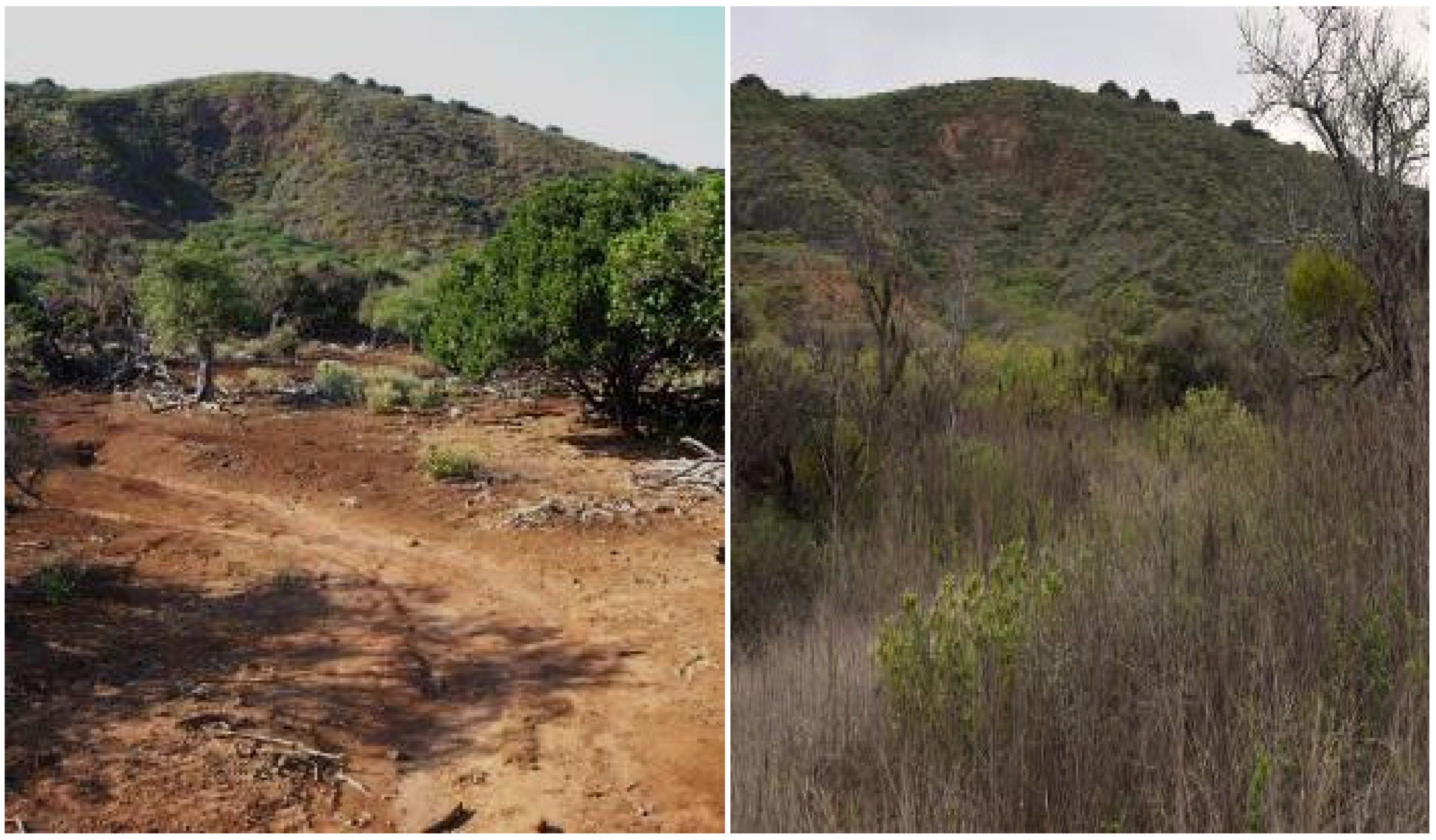
3.2. Field Assessment of Vegetation

When doing field verification, we found that the outcome of the satellite images corresponded to the actual habitat condition (Figure 4). Due to the presence of sheep, most studied sites lacked vegetation, and few species were present in 2009 (Table 2). Additionally, trails made by the sheep were observed with compacted soils.
Statistical tests showed significant differences from 2009 to 2013 in the number of species present in the eroded sites as well as in coverage percentage. As shown in Table 2, it was possible to record an evident recovery in all of the habitats in 2013, i.e., the forest habitat with the highest values, followed by the mixed scrub, and then the eroded surface.
After sheep eradication from the island, among the pioneer plants that began the colonization of eroded sites, not only were native and endemic species present, but the exotic ones were as well. Shrubs and herbs were the most successful life forms. The results indicated that there were differences among the northeast-southeast zones of the sampling area. Native species such as Pteridium caudatum (L.) Maxon and Dodonaea viscosa Jacq. were those with higher densities and the most dominant species in the sampling area. Hyptis pectinata (L.) Poit. was one of the most prolific exotic species (Table 3).

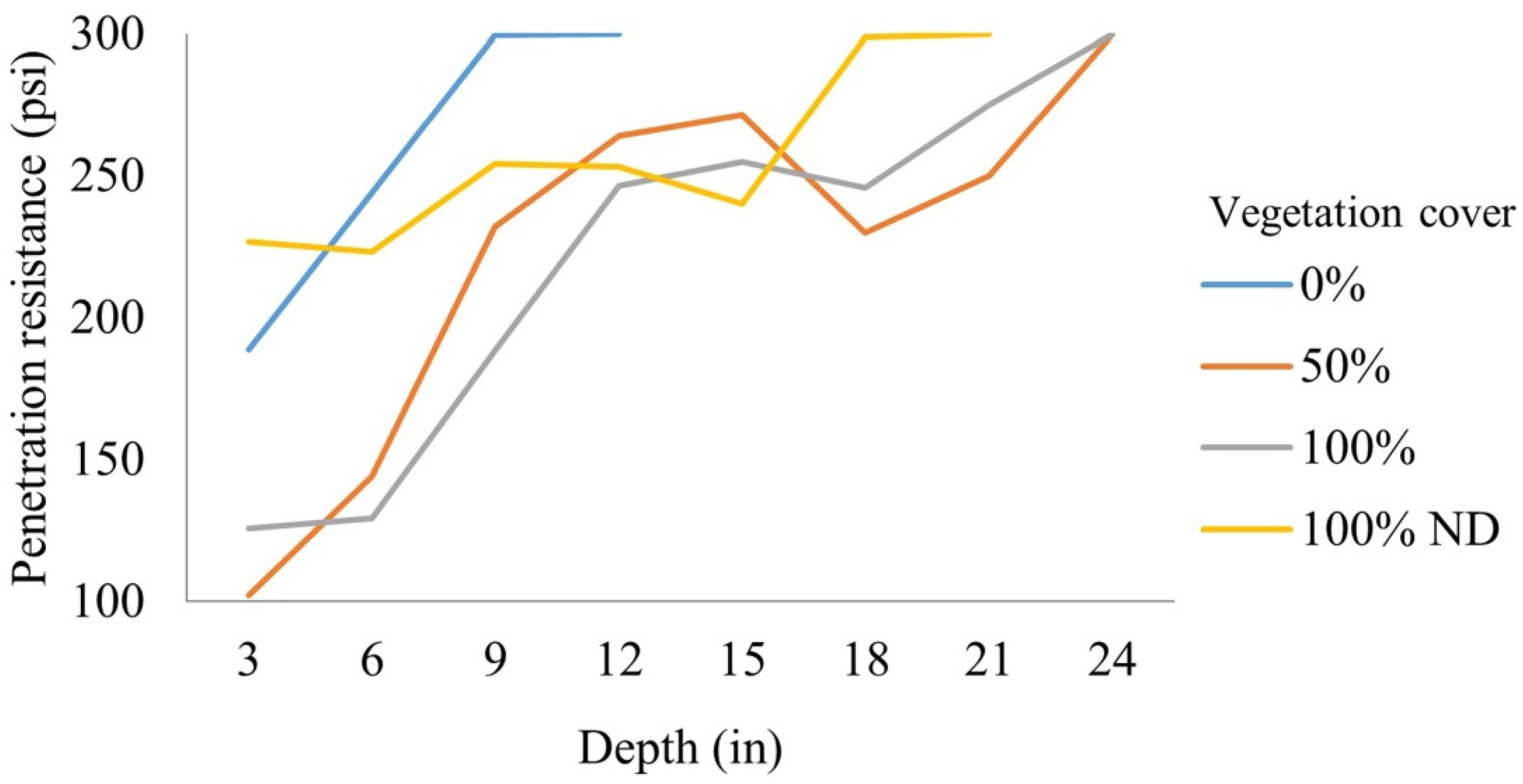
3.3. Soil Compaction

The results of the study of soil compaction showed that eroded soils were the most compacted and had become less compacted as vegetation began to recover (50% and 100% recovered vegetation cover). Transects that retained eroded soils (0% vegetation) showed greater penetration resistance (>300 pounds-force per square inch, or psi, to 12 inches deep), resulting from the rams [51,52,53]. In relation to sites with 50% and 100% recovered vegetation cover, soils were very compacted and shallow (100–120 psi to three inches deep) and became more compacted at greater depths (300 psi to 24 inches deep). At sites with 100% coverage without disturbance (ND), the soil was kept with little variation (230–300 psi until 21 inches depth), which was in the range of values conducive for the growth of most plants from 200–400 psi to 24 in [54], which could be due to the constant stable condition. Significant differences (p < 0.001) were observed among sites with 0% and those with 50% and 100% recovered vegetation cover. Significant differences were found between sites with 50% and 100% recovered coverage compared to undisturbed sites (100% ND, Figure 5).

3.4. Physical-Chemical Soil Parameters

The results of physical-chemical analyses of soil samples are shown in Table 4; pH values remained close to neutral, showing a significant difference (p < 0.021) between sites without vegetation and 50% vegetation cover. Electrical conductivity, which is an indicator of salt presence in soil, also had significant differences (p < 0.013) between the eroded and 100% vegetation cover sites, although no difference was observed between eroded soils and those that were not disturbed.
In the case of total nitrogen, organic carbon, phosphorus, and calcium, sites with recovered vegetation were significantly different (p < 0.001) than those with erosion. Both nitrogen and organic carbon doubled, while phosphorus and calcium values almost tripled in places with increased vegetation cover regarding the eroded sites.
Meanwhile, magnesium showed significant differences among the eroded sites (0%, 50%, and 100% recovered vegetation cover) and undisturbed sites (100% ND). The sites that were never altered by the presence of sheep exhibited a concentration twice that of disturbed sites.

4. Discussion

4.1. NDVI and Field Assessment of Vegetation

Remote sensing allows for easy analysis of extended and/or complex areas difficult to access. In our study, NDVI was a useful tool to evaluate changes in photosynthetic vegetation along time, especially in an island with a very complex topography with plenty of areas difficult to reach. The results of this analysis support those obtained in field assessment in a more quantitative way, specifically the increment in vegetal coverage.
We found differences not only in the number of species and vegetation cover in the sampling area between 2009 and 2013 but also in the habitats located along the northeast-southeast zones of the sampling area. The forests and mixed scrubs in the southeast zone showed the greatest recovery, probably favored by their vegetal components (Table 2 and Table 3) and the permanence of seed banks because of a more stable landscape in addition to water availability due to precipitation patterns; the endemic tree species recovering were Guettarda insularis and Psidium socorrense. The smaller number of plant species found in the isolated patches of mixed scrubs included in large expanses of erosion in the northeast zone could be due to slope steepness and wind exposure in this area. Gravity would make the permanence of naturally occurring soil seed bank difficult.
Some species of exotic grasses have also been favored with sheep eradication because they are no longer grazed on. Species of the genera Aristida and Cenchrus are now more abundant near roads where vehicles can travel on the island.
Herbivores can affect plant species diversity by modifying local extinction or colonization rates, or both. The question whether herbivores increase or decrease plant diversity over a productivity gradient thus translates into the question of how herbivores impact extinction and colonization rate changes with productivity [55]. In the case of Socorro Island, productivity can be qualitatively evaluated based on the NDVI analysis results because it shows the increment in vegetal coverage, i.e. in biomass. These results evidence the strong negative impact that sheep had on vegetation due to their permanence on the island.
The introduction of large grazers is crucial for plant diversity worldwide. Nutritional quality of plants growing in poor soils is low, so large herbivores require a lot of forage to feed on. Large herbivorous should not be introduced everywhere, as they can have negative effects on diversity, especially in unproductive areas or areas that have no recent evolutionary history of abundant large herbivore grazing [56], as in the case of Socorro Island.
The ecological resilience corresponds to the degree to which the system would have to be altered before it begins to reorganize itself around another set of processes. Small and fast scales are dominated by biophysical processes that control plant physiology and morphology [34]. In the case of Socorro Island, a fragile ecosystem with endemism and no naturally occurring large herbivores, sheep disturbance elimination evidences the importance of plant composition in the recovery of certain species. Some endemic species such as Erigeron socorrensis and Perityle socorrensis have successfully colonized eroded soil, even taking advantage of microhabitats created by H. pectinata and D. viscosa, which could be due to the long-term evolution in isolation and adaptation to an exceedingly harsh substrate and climate, as established by Walter and Levin [24].
At the larger and slower scale of patch dynamics, interspecific plant competition for nutrients, light, and water influences local species composition and regeneration [34]. Some plants colonizing eroded soils could become very aggressive, likely preventing biodiversity recovery. Such could be the case of Pteridium caudatum, a successful fern species that thrives worldwide in disturbed sites and in different climates and soil types, which, in 2013, had covered extended surfaces in Socorro Island.
Finally, at a still larger scale of stands in a forest, mesoscale processes determine structure and successional dynamics from tens of meters to kilometers, and from years to decades [34]. As Walter and Levin [24] argued, our results support the possibility that sheep removal would be followed by the eventual return of the former island vegetation, which seems possible given that only a year after the eradication of feral sheep concluded, the natural ecosystems of Socorro Island showed signs of passively recovering.

4.2. Soil Recovery

The changes in soil physical-chemical properties in Socorro Island seem to be related to the gradual recovery of vegetation after the eradication of feral sheep. From 2009, the first plants to colonize disturbed areas (Table 3) were detected. Prostrate Chamaesyce sp. and E. socorrensis have been observed to have a great capacity to retain soil. H. pectinata and P. caudatum settled in high densities; in addition to retaining soil, they have generated much organic matter. Possibly the most successful species to colonize disturbed areas has been D. viscosa, which has a great ability to germinate in eroded soil [40], generating organic matter and preventing the germination of other species [57]. In the absence of trampling, soil aggregate stability increases, which enhances infiltration, reduces erosion, and may promote nutrient accumulation and soil retention [58,59].
As pioneer plants began to establish, the ground became less compacted because the roots of plants, particularly annual grasses in these stages, act as biological perforators, also incorporating organic matter into the soil; once the roots die and shrink, these pores are large enough to allow the roots of perennial shrubs to penetrate [60]. Greater ease of water movement in the soil matrix, coupled with heavy rainfall, could be causing leaching and replacing cations with H+ ions, acidifying the soil. Another cause may be nutrient absorption by plant roots, decreasing the concentration of basic cations (Ca, Mg, K, and Na). In the case of electrical conductivity, the average values from 0.07 and 0.09 dS m−1 were not considered limiting for normal plant development [61].
Both the results obtained with the NDVI calculation and field observations suggested that some pioneer plants had the ability to germinate on eroded soils and were instrumental in the succession process by providing the right conditions such that tree species could germinate. The progressive increase in vegetation cover reduces soil compaction and restores the biogeochemical cycles of essential nutrients, such as nitrogen, phosphorus, and calcium, which are essential for the recovery of communities and the ecosystem in general, as well as the incorporation of carbon on the ground, which is essential for the proper functioning of important microbiological component.
Any change in the habitat that produces changes in litter production, soil aeration, or any other factor affecting microorganisms will be reflected in changes in biogeochemical cycles, such as those of carbon and nitrogen [62]. The recovery in these important cycles on the island has been allowing the establishment of species that need these elements available in the soil in order to establish. Although the significant difference in the results of organic carbon and nitrogen seems to correspond to the observed recovery, it is important to mention that it might be due to the high values in the standard deviations obtained for all the vegetation cover conditions.
The magnesium content can be explained as a result of the weathering of mafic rocks, which are rich in magnesium and iron [63] and not by the litter of pioneer plants that have gained a foothold in poor soils.

5. Conclusions

Some studies have discussed the importance of herbivorous species of small or large size, having discrepancy as to the negative or positive effect they can have [55]. For this reason, large herbivores should not be introduced in environments where environmental conditions of precipitation and humidity are not balanced, as in the case of Socorro Island.
Removing the exotic herbivorous species from the island is a conservation tool [7], which is evident in its recovery contribution of the natural environment. Habitat fragmentation and degradation caused by the presence of invasive species (Ovis aries) was evident on the island, whose main involvement was on the ground and in vegetation. The resistance of native species has been transcendental not only in the relatively rapid recovery of the vegetation cover but also in offering the possibility of recovering the former island vegetation.
The results reflect the important role of vegetation in erosion control, both for establishing mechanical support due to its roots in the soil structure and in capturing water flow and nutrients, providing fresh organic matter to the soil, thus restoring biogeochemical cycles and ecosystem processes.
The time after sheep removal has so far been too short to determine ecosystem behavior, but it is clear that the system had already started changing by 2013. With the habitat recovery, wildlife recovery is expected as food availability and resources for the native species of the island gradually increase.
The results of this study seem to support our hypothesis that Socorro Island is resilient enough to recover in a relatively small time scale, after the removal of the pressures caused by a large exotic herbivore.

Acknowledgments

The authors thank CIBNOR staff Gil Ceseña for advice and support in the GIS Laboratory; Manuel Trasviña and Myriam Hernandez for advice and support in the Soil Science Laboratory; Diana Dorantes for editorial services in English; the staff of Grupo de Ecología y Conservación de Islas, A.C. for support during the expeditions to Socorro Island; and two anonymous reviewers for their critical and helpful comments. This work has been funded by various organizations, including the National Network of Protected Areas RENANP of CONACYT, grant 259540, Grupo de Ecología y Conservación de Islas, A.C., and the WWF–Carlos Slim Foundation Alliance, grant Gca 2014-11.

Author Contributions

Alfredo Ortega-Rubio, Antonio Ortiz-Alcaraz, and Yolanda Maya-Delgado conceived and designed the experiment; Alfonso Aguirre-Muñoz, and Evaristo Rojas-Mayoral contributed with reagents and materials, statistical analysis and discussion; Antonio Ortiz-Alcaraz and Patricia Cortés-Calva analyzed the data; Alfredo Ortega-Rubio and Miguel V. Cordoba-Matson contributed with analysis tools; Antonio Ortiz-Alcaraz, Yolanda Maya-Delgado, and Patricia Cortés-Calva wrote the paper.

Conflicts of Interest

The authors declare no conflict of interest.

References

  1. Mason, H.L. The edaphic factor in narrow endemism. II. The Geographic occurrence of plants of highly restricted patterns of distribution. Madroño 1946, 8, 241–257. [Google Scholar]
  2. Tilman, D.; May, R.M.; Lehman, C.L.; Nowak, M.A. Habitat destruction and the extinction debt. Nature 1994, 371, 65–66. [Google Scholar] [CrossRef]
  3. Coblentz, B.E. The effects of feral goat (Capra hircus) on islands ecosystems. Biol. Cons. 1978, 13, 279–286. [Google Scholar] [CrossRef]
  4. Eberhard, T. Introduced birds and mammals and their ecological effects. Swed. Wildl. Res. 1988, 13, 1–107. [Google Scholar]
  5. Rosenberg, D.K. The impact of introduced herbivores on the Galapagos rail (Laterallus spilonotus). Monogr. Syst. Bot. Missour.i Bot. Gard. 1990, 32, 169–178. [Google Scholar]
  6. Mooney, H.A.; Hobbs, R.J. Invasive Species in a Changing World; Island Press: Washington, DC, USA, 2000. [Google Scholar]
  7. Donlan, C.J.; Tershy, B.R.; Croll, D.A. Islands and introduced herbivores: Conservation action as ecosystem experimentation. J. Appl. Ecol. 2002, 39, 235–246. [Google Scholar] [CrossRef]
  8. Primack, R.B. Essentials of Conservation Biology; Sinauer Associates Press: Sunderland, MA, USA, 2002. [Google Scholar]
  9. Veitch, C.R.; Clout, M.N. Turning the Tide: The Eradication of Invasive Species; IUCN, SSC Invasive Species Specialist Group: Gland, Switzerland, 2002; pp. 374–380. [Google Scholar]
  10. Courchamp, F.; Chapuis, J.L.; Pascal, M. Mammal invaders on islands: Impact, control, and control impact. Biol. Rev. 2003, 78, 347–383. [Google Scholar] [CrossRef] [PubMed]
  11. Nogales, M.; Martín, A.; Tershy, B.R.; Donlan, C.J.; Veitch, D.; Puerta, N.; Wood, B.; Alonso, J. A Review of feral cat eradication on islands. Cons. Biol. 2004, 18, 310–319. [Google Scholar] [CrossRef]
  12. Campbell, K.; Donlan, C.J. Feral goat eradication on islands. Cons. Biol. 2005, 19, 1362–1374. [Google Scholar] [CrossRef]
  13. Pimentel, D.; Zúñiga, R.; Morrison, D. Update on the environmental and economic costs associated with alien invasive species in the United States. Ecol. Econ. 2005, 52, 273–288. [Google Scholar] [CrossRef]
  14. Aguirre-Muñoz, A.; Samaniego-Herrera, A.; Luna-Mendoza, L.; Ortiz-Alcaraz, A.; Rodríguez-Malagón, M.; Méndez-Sánchez, F.; Félix-Lizárraga, M.; Hernández-Montoya, J.; González-Gómez, R.; Torres-García, F.; et al. Island restoration in Mexico: Ecological outcomes after systematic eradications of invasive mammals. In Island Invasives: Eradication and Management; Veitch, C.R., Clout, M.N., Towns, D.R., Eds.; IUCN: Gland, Switzerland, 2011; pp. 250–258. [Google Scholar]
  15. MacArthur, R.H.; Wilson, E.O. The Theory of Island Biogeography. Vol 1; Princeton University Press: Princeton, NJ, USA, 1967. [Google Scholar]
  16. Álvarez-Castañeda, S.T.; Ortega-Rubio, A. Current status of rodents on islands of the Gulf of California. Biol. Cons. 2003, 109, 157–163. [Google Scholar] [CrossRef]
  17. Blumstein, D.T.; Daniel, J.C. The loss of anti-predator behavior following isolation on islands. Proc. R. Soc. B Biol. Sci. 2005, 272, 1663–1668. [Google Scholar] [CrossRef] [PubMed]
  18. Cortés-Calva, P.; Gallo-Reynoso, J.P.; Delgadillo-Rodríguez, J.; Lorenzo, C.; Álvarez-Castañeda, S.T. The effect of feral dogs and other alien species on native mammals of Isla de Cedros, Mexico. Nat. Areas J. 2013, 33, 466–473. [Google Scholar] [CrossRef]
  19. Cincotta, P.R.; Wisnewski, J.; Engelman, R. Human population in the biodiversity hotspot. Nature 2000, 404, 990–992. [Google Scholar] [CrossRef] [PubMed]
  20. Whittaker, R.J.; Fernandez-Palacios, J.M. Island Biogeography; Oxford University Press: Oxford, UK, 2007. [Google Scholar]
  21. Donlan, C.J.; Croll, D.A.; Tershy, B.R. Islands, exotic herbivores, and invasive plants: Their roles in Coastal California restauration. Res. Ecol. 2003, 11, 524–530. [Google Scholar] [CrossRef]
  22. Álvarez-Cárdenas, S.; Castellanos, A.; Galina, P.; Ortega-Rubio, A.; Arnaud, G. Aspectos de la población y el hábitat del borrego doméstico (Ovis aries). In La Isla Socorro, Reserva de la Biosfera Archipiélago de Revillagigedo, México; Ortega Rubio, A., Castellanos, A., Eds.; Centro de Investigaciones Biológicas del Noroeste S.C.: La Paz, Mexico, 1994; pp. 301–317. [Google Scholar]
  23. Villa, B. La Isla Socorro. Vertebrados terrestres. Monogr. Inst. Geofís. 1960, 2, 203–2016. [Google Scholar]
  24. Walter, H.S.; Levin, G.A. Feral sheep on Socorro Island: Facilitators of alien plant colonization and ecosystem decay. Divers. Distrib. 2008, 14, 422–431. [Google Scholar] [CrossRef]
  25. Richards, A.F.; Brattstrom, B.H. Bibliography, cartography, discovery and exploration of the islas Revillagigedo. Proc. Calif. Acad. Sci. 1959, 29, 315–360. [Google Scholar]
  26. Veitch, C.R. The Eradication of Cats and Sheep from Socorro Island: A Report to the Socorro Island Project; Northern Region Technical Report Series No. 11; Department of Conservation: Auckland, New Zealand, 1989. [Google Scholar]
  27. Castellanos, A.; Arnaud, G.; Álvarez, S.; Rodríguez, R.; Galina, P. El borrego doméstico (Ovis aries) en isla Socorro, su situación actual e impacto en el suelo, la vegetación y la fauna nativa. In Proceedings of the XI Congreso Nacional de Zoología, Mérida, Mexico, 28–31 October 1991.
  28. Ortega, A.; Castellanos, A.; Arnaud, G.; Maya, Y.; Rodríguez, R.; León, J.L.; Cancino, J.; Jiménez, C.; Llinas, J.; Álvarez, S.; et al. Estudio de los Recursos Naturales de la Isla Socorro, Revillagigedo. Ciencia 1992, 43, 175–184. [Google Scholar]
  29. Castellanos, A.; Rodríguez-Estrella, R. Current status of the Socorro Mockingbird. Wilson Bull. 1993, 105, 167–171. [Google Scholar]
  30. Galina, P.; Álvarez, S.; Ortega Rubio, A. Aspectos ecológicos de la herpetofauna. In La Isla Socorro, Reserva de la Biosfera Archipiélago de Revillagigedo, México; Ortega Rubio, A., Castellanos, A., Eds.; Centro de Investigaciones Biológicas del Noroeste S.C.: La Paz, Mexico, 1994; pp. 185–197. [Google Scholar]
  31. Rodríguez-Estrella, R.; Rivera-Rodríguez, L.; Mata, E. Avifauna Terrestre. In La Isla Socorro, Reserva de la Biosfera Archipiélago de Revillagigedo, México; Ortega Rubio, A., Castellanos, A., Eds.; Centro de Investigaciones Biológicas del Noroeste S.C.: La Paz, Mexico, 1994; pp. 199–224. [Google Scholar]
  32. Maya-Delgado, Y.; Salinas-Zavala, F.; Troyo-Diéguez, E. Estado actual del suelo y propuestas para su conservación. In La Isla Socorro, Reserva de la Biosfera Archipiélago de Revillagigedo, México; Ortega Rubio, A., Castellanos, A., Eds.; Centro de Investigaciones Biológicas del Noroeste S.C.: La Paz, Mexico, 1994; pp. 63–75. [Google Scholar]
  33. Adema, E.O.; Babinec, F.J.; Peinemann, N. Pérdida de nutrientes por erosión hídrica en dos suelos del cardenal pampeano. Cienc. Suelo 2001, 19, 144–154. [Google Scholar]
  34. Peterson, G.; Allen, C.R.; Holling, C.S. Ecological resilience, biodiversity, and scale. Ecosystems 1998, 1, 6–18. [Google Scholar] [CrossRef]
  35. Zavaleta, E.S.; Hobbs, R.J.; Mooney, H.A. Viewing invasive species removal in a whole-ecosystem context. Trends Ecol. Evol. 2001, 16, 454–459. [Google Scholar] [CrossRef]
  36. Holl, K.D.; Aide, T.M. When and where to actively restore ecosystems? Forest Ecol. Manag. 2011, 261, 1558–1563. [Google Scholar] [CrossRef]
  37. Jones, H.P.; Schmitz, O.J. Rapid Recovery of Damaged Ecosystems. PLoS ONE 2009, 4, 53–56. [Google Scholar] [CrossRef] [PubMed]
  38. CONANP-SEMARNAT. Programa de Conservación y Manejo, Reserva de la Biósfera Archipiélago de Revillagigedo; Comisión Nacional de Áreas Naturales Protegidas: Mexico, D.F., Mexico, 2004. [Google Scholar]
  39. León de la Luz, J.L.; Breceda, A.; Coria, R.; Cancino, J. Asociaciones vegetales. In La Isla Socorro, Reserva de la Biosfera Archipiélago de Revillagigedo, México; Ortega Rubio, A., Castellanos, A., Eds.; Centro de Investigaciones Biológicas del Noroeste S.C.: La Paz, Mexico, 1994; pp. 115–141. [Google Scholar]
  40. Campa-Molina, M.A. Flora y potencial apícola de Isla Socorro, Archipiélago de las Revillagigedo. Master’s Thesis, Universidad de Guadalajara, Jalisco, Mexico, 1989. [Google Scholar]
  41. Levin, G.A.; Moran, R. The Vascular Flora of Isla Socorro, Mexico; San Diego Society of Natural History: San Diego, CA, USA, 1989. [Google Scholar]
  42. Hall, E.R. The Mammals of North America; Wiley Inter-Sciences Publications: New York, NY, USA, 1981; p. 191. [Google Scholar]
  43. Ortiz-Alcaraz, A.; Barredo-Barberena, J.M.; Aguirre-Muñoz, A.; Santos del Prado-Gasca, K. Acciones para la Recuperación del Ambiente en Isla Socorro, Archipiélago de Revillagigedo. Reporte Final; Grupo de Ecología y Conservación de Islas, A.C.-Instituto Nacional de Ecología: Mexico City, Mexico, 2011; p. 32. [Google Scholar]
  44. Valdez-Lazalde, J.; González-Guillen, M.; de los Santos-Posadas, H. Estimación de cobertura arbórea mediante imágenes satelitales multiespectrales de alta resolución. Agrociencia 2006, 40, 383–394. [Google Scholar]
  45. Cabral, F. Dinámica espaciotemporal de uso del suelo en la UMAFOR 12 del Estado de México mediante el uso de sistemas de información geográfica (1990–2007). Master’s Thesis, Universidad Autónoma Chapingo, Mexico, 2011. [Google Scholar]
  46. Mostacedo, B.; Fredericksen, T.S. Manual de Métodos Básicos de Muestreo y Análisis en Ecología Vegetal; Proyecto de Manejo Forestal Sostenible (BOLFOR): Santa Cruz, Bolivia, 2000. [Google Scholar]
  47. Ortiz-Alcaraz, A.; Aguirre-Muñoz, A.; Méndez-Sánchez, F.; Ortega-Rubio, A. Feral sheep eradication at Socorro Island, México: A mandatory step to ensure ecological restoration. Interciencia 2016, 41, 184–189. [Google Scholar]
  48. Jackson, M.L. Análisis químico de suelos, 4th ed.; Ediciones Omega S.A.: Barcelona, Spain, 1982; p. 652. [Google Scholar]
  49. Bates, R.G. Determination of pH. Theory and Practice; John Wiley and Sons: New York, NY, USA, 1964; pp. 11–12. [Google Scholar]
  50. Page, A.L.; Miller, R.H.; Keeney, D.R. Methods of Soil Analysis. Part 2, Chemical and Microbiological Properties, 2nd ed.; American Society of Agronomy, Inc. and Soil Science Society of America, Inc: Wisconsin, WI, USA, 1982; p. 1159. [Google Scholar]
  51. Pinzón, A.; Amézquita, E. Compactación de suelos por pisoteo de animales en pastoreo en el piedemonte amazónico de Colombia. Pasturas tropicales 1979, 13, 21–26. [Google Scholar]
  52. Riney, T. Study and management of large mammals; John Wiley & Sons Ltd.: Chichester, UK, 1982. [Google Scholar]
  53. González, M.; Nogues, E. Pisoteo animal y su efecto en la densidad aparente del suelo en un Haplustol franco arenoso bajo diferentes manejos. Rev. Divulg. Técnic. Agríc. Agroind. 2012, 31, 1–9. [Google Scholar]
  54. Bakker, E.S.; Ritchie, M.E.; Olff, H.; Milchunas, D.G.; Knops, J.M.H. Herbivore impact on grassland plant diversity depends on habitat productivity and herbivore size. Ecol. Lett. 2006, 9, 780–788. [Google Scholar] [CrossRef] [PubMed]
  55. Milchunas, D.G.; Sala, O.E.; Lauenroth, W.K. A generalized model of the effects of grazing by large herbivores on grassland community structure. Am. Nat. 1988, 132, 87–106. [Google Scholar] [CrossRef]
  56. Vibrans, H. Taller de identificación de Malezas. In Manejo de Malezas en México. Vol. 1 Maleza terrestre; Bojórquez-Bojórquez, G., Rosales-Robles, E., Zeta-Padilla, G., Eds.; Universidad Autónoma de Sinaloa: Culiacan, Mexico, 2011; pp. 293–308. [Google Scholar]
  57. Castellano, M.J.; Valone, T.J. Livestock, soil compaction and water infiltration rate: Evaluating a potential desertification recovery mechanism. J. Arid Environ. 2007, 71, 97–108. [Google Scholar] [CrossRef]
  58. Allington, G.R.H.; Valone, T.J. Reversal of desertification: The role of physical and chemical soil properties. J. Arid Environ. 2010, 74, 973–977. [Google Scholar] [CrossRef]
  59. Amézquita, E.; Chávez, L.F. La compactación del suelo y sus efectos en la productividad de los suelos. In Proceedings of the Congreso Costarricense de la Ciencia del Suelo, San José, Costa Rica, 9 April 1999.
  60. Sellés, G.; Fereyra, R.; Ruíz, R.; Ferreyra, R.; Ahumada, R. Compactación de Suelos y su Control: Estudio de Casos en el Valle de Aconcagua, Boletín INIA 234; Instituto de Investigaciones Agropecuarias: Santiago, Chile, 2012. [Google Scholar]
  61. USDA. Soil Survey Laboratory Methods Manual. Soil Survey Investigations Report No. 42. Version 3.0; Natural Resources Conservation Service: Washington, DC, USA, 1996. [Google Scholar]
  62. Hartmann, A.; Aßmus, B.; Kirchhof, G.; Schloter, M. Direct approaches for studying soil microbes. In Modern Soil Microbiology; van Elsas, J.D., Trevors, J.T., Wellington, E.M.H., Eds.; Marcel Dekker Inc.: New York, NY, USA, 1997; p. 712. [Google Scholar]
  63. Mediavilla, M.J. Meteorización química. Enseñanza de las Ciencias de la Tierra; Universidad de Girona: Girona, Spain, 2014; pp. 230–238. [Google Scholar]
Figure 1. Location of Socorro Island and location of the sampling transects of vegetation and soils. (a) Mexico; (b) Revillagigedo Archipelago; (c) sampling area in the central-southeast of Socorro Island.
Forests 07 00091 g001
Figure 2. Maps of the normalized difference vegetation index (NDVI) obtained from images of Socorro Island. Left: QuickBird, 11 May 2008; Right: WorldView 2, 9 May 2013.
Forests 07 00091 g002
Figure 3. Map of recovery and increase of vegetation cover in 2013 (red). Dashed lines indicate the portions of the island to which reference is made in Table 1.
Forests 07 00091 g003
Figure 4. Forest recovery. Left: Site eroded in 2009. Right: Recovery of vegetation in 2013.
Forests 07 00091 g004
Figure 5. Soil compaction in eroded areas and areas without disturbance (ND).
Forests 07 00091 g005
Table 1. Average values of NDVI in 2008 and 2013.
Portions of the Island20082013Difference
Northwest (NW)0.4430.5010.058
Northeast (NE)0.4610.6120.150
Southwest (SW)0.3940.4990.105
Southeast (SE)0.3460.5330.187
Table 2. Vegetation cover in the 20 transects studied in 2009 and 2013.
Type of HabitatNo. of Plant SpeciespVegetation Cover (%)p
2009201320092013
Forest8.86 (± 4.41)15.00 (± 2.31)*29.29 (± 8.38)85.00 (± 9.24)**
Mixed scrub6.67 (± 2.73)13.67 (± 4.23)*19.17 (± 2.99)72.50 (± 11.54)**
Eroded surface4.71 (3.45)8.29 (± 2.56)**14.29(± 4.27)50.29 (± 16.13)**
Type of habitat based on the classification of León de la Luz et al. [39]. *, p < 0.005; **, p < 0.001.
Table 3. Maximum density and life forms of the plant species of major occurrence in the colonization of eroded soil in transects in 2009 and 2013. A p < 0.001 was observed between 2009 and 2013 for all the species. (ind ha−1) = individuals per hectare.
SpeciesLife FormZones within the Sampling Area
NortheastSoutheast
ind ha−1Increase(%)ind ha−1Increase(%)
2009201320092013
Hyptis pectinata (L.) Poit. (x)Shrub6021035033048601473
Dodonaea viscosa Jacq. (n)Shrub91061906801401370979
Pteridium caudatum (L.) Maxon (n)*Herbs6%58%96711%43%391
Nicotiana stocktonii Brandegee (e)Herbs3019063340260650
Erigeron socorrensis Brandegee (e)Herbs240142059280350437
Mitracarpus hirtus (L.) DC. (x)Herbs804405502090450
Aristida spp. (x)^*Herbs1%3%3006%31%517
Amaranthus palmeri S.Watson (n)Sub-shrub220900409100180180
Psidium socorrense I.M.Johnst. (e)Tree5019038030100333
Chamaesyce spp. (x)^Herbs70160229100370370
Cenchrus spp. (x)^Herbs40110275160530331
Guettarda insularis Brandegee (e)Tree80220275170320188
Perityle socorrosensis Rose (e)Herbs390780200310620200
Type of life-form based on Levin and Moran [41]; * Due to the impossibility of accounting for individual plants, only % coverage per hectare was considered; only ^ are located close to the paths on the island transects; n = native; e = endemic; x = exotic.
Table 4. Results of soil physical-chemical analyses.
Vegetation Cover
0%50%100%100% ND
pH7.20 (0.16)a6.99 (0.28)b7.03 (0.16)a,b7.11 (0.22)a,b
Electrical conductivity (dS m−1)0.09 (0.03)a0.07 (0.03)a0.07 (0.02)b0.09 (0.03)a
Total nitrogen (%)0.20 (0.07)a0.45 (0.11)b0.48 (0.14)b0.51 (0.17)b
Organic carbon (%)1.53 (0.52)a3.60 (0.86)b3.22 (0.78)b3.27 (1.08)b
Phosphorus (meq 100g−1)0.01 (0.01)a0.03 (0.02)b0.03 (0.02)b0.03 (0.02)b
Calcium (meq 100g−1)0.03 (0.01)a0.08 (0.04)b0.05 (0.02)b0.09 (0.03)b
Magnesium (meq 100g−1)0.10 (0.04)a0.10 (0.03)a0.11 (0.03)a0.20 (0.10)b
ND = Non-disturbed area with little or no alteration by sheep. The numbers in parenthesis are the standard deviation; values followed by different lowercase letter (a, b) indicate that means are significantly different among eroded and non-eroded conditions. The correspondent p values for each case is specified in the text.

