Interpreting the Inheritance Mechanism of the Wu Yue Sacred Mountains in China Using Structuralist and Semiotic Approaches

Faculty of Geographical Science, Beijing Normal University, Beijing 100875, China
*
Authors to whom correspondence should be addressed.
Sustainability 2018, 10(7), 2127; https://doi.org/10.3390/su10072127
Submission received: 22 April 2018
/
Revised: 12 June 2018
/
Accepted: 16 June 2018
/
Published: 22 June 2018
(This article belongs to the Special Issue Local Heritage and Sustainability)
Abstract
:The sustainability of sacred mountains has attracted the attention of both international communities and scholars. However, few studies have focused on the sustainability mechanisms of sacred mountains in the cultural dimension. This article presents a case study of the Wu Yue, i.e., five sacred mountains in China, which is endowed with the highest status and has been a sustainable cultural heritage for more than two thousand years. Drawing on the approaches of structuralist geography and semiotics, this article seeks to systematically interpret the inheritance mechanism of the Wu Yue. Two major conclusions are drawn. First, based on the approach of structuralist geography, the spatial structure of the Wu Yue can be viewed as a surface structure that is determined by a deep structure: the Five Elements Philosophy. Despite the relocation of the South Yue and the North Yue, each mountain of the Wu Yue has almost always been located in the five cardinal directions of the territory in accordance with the Five Elements Philosophy; this fact shows that the deep structure is crucial to maintaining the sustainability of the Wu Yue. Second, based on the semiotic approach, the sign of the sacred mountains has three levels. It is the third level of the sign, consisting of the spatial pattern as signifier and the Five Elements Philosophy as signified, that distinguishes the Wu Yue from other sacred mountains and has allowed them to be inherited for many generations. Poststructuralism can explain the Chinese semiotics of sacred mountains, but it is difficult to interpret the sustainability of the Wu Yue.
1. Introduction
Many places in the world have sacred mountains [1,2,3]. As the highest geographical entities on the earth’s surface, sacred mountains occupy a special and important position in many cultures [4,5]. Examples include Mount Zion in Jerusalem, Mount Olympus in Greece, Mount Fuji in Japan, and the San Francisco Peaks in Arizona (USA). These sacred mountains and their sacredness have become the tangible and intangible cultural heritage of nations and local communities, passed down from one generation to the next [6].
There are also many sacred mountains in China. Among these, the Wu Yue, which are addressed in this article, have supreme status and authority, wielding considerable influence. In Chinese, the word “Wu” means five, and “Yue” refers to a sacred mountain that is endowed with a higher status than common mountains. Currently, the term “Wu Yue” refers to five sacred mountains: Mount Tai is the East Yue (Figure 1a); Mount Heng is the South Yue (Figure 1b); Mount Hua is the West Yue (Figure 1c); Mount Heng is the North Yue (Figure 1d); and Mount Song is the Center Yue (Figure 1e). The history of the Wu Yue can be traced back to the Spring and Autumn period (770 BC to 476 BC) and the Warring States Period (475 BC to 221 BC). Ancient books from those periods also mention the Si Yue, which means four sacred mountains. However, these books do not refer to the geographical entities of the Wu Yue accurately and unambiguously. In the Western Han Dynasty (202 BC to 9 AD), the central government officially designated, for the first time, five specific sacred mountains as constituting the system of the Wu Yue. Following this official designation, emperors began to worship the Wu Yue to ensure the peace and wealth of the empire. Since then, the Wu Yue have assumed the highest position among all mountain ranges in China.
An interesting phenomenon to be discussed here is that although the geographical entities of the Wu Yue have changed several times throughout Chinese history, the cultural meaning of the Wu Yue has remained remarkably constant for more than two thousand years. This phenomenon distinguishes the Wu Yue from other sacred mountains around the world. Sacred Mountains of the World, a monograph on sacred mountains, details the sacred mountains in various civilizations and discusses their sacredness. The sacred mountains mentioned in that book have fixed locations. In contrast, major changes in the geographical entities comprising China’s Wu Yue occurred during the following periods. In 589 AD, the geographical entity of the South Yue changed from Mount Huo in today’s Anhui Province to Mount Heng in today’s Hunan Province. In 1660 AD, the emperors changed the North Yue’s location from Quyang County in today’s Hebei Province to Hunyuan County in present-day Shanxi Province. In addition, the idea of the Wu Yue has influenced the political powers surrounding the Chinese empire, including the Silla dynasty on the Korean Peninsula and the Nanzhao Kingdom on the Yunnan-Guizhou Plateau. Historically, these political powers also had their own Wu Yue.
Drawing on ancient books containing information about the Wu Yue, this article seeks to systematically interpret the inheritance mechanism of the Wu Yue across more than 2000 years to contribute to knowledge of mountain geography in the following ways. First, many themes in mountain research are now being readdressed within the framework of sustainability, focusing especially on environmental sustainability [7,8] and sustainable livelihoods [9,10,11]. Little attention has been paid to the sustainability of mountains in the cultural dimension [12,13,14]. This article presents a case study of the Wu Yue, i.e., five sacred mountains in China, which have been recognized by Chinese people since the Warring States Period; such an investigation improves our understanding of the cultural sustainability of mountains. Second, both structuralist geographical and semiotic approaches are applied to fill the methodological gap that has hindered those conducted mountain researches from being able to identify the factors underlying the cultural sustainability of mountains. Third, this article contributes to answering the why, what and how of conserving the Wu Yue in the past, present and future.
2. Literature Review
2.1. The Structuralist Geography Approach to Sacred Mountains Research
What is the structuralist approach to human geography? Structuralism, as a theoretical approach, contends that a structure is typically composed of both a surface structure and a deep structure and that both are important in understanding our human society; structuralist inquiry requires discovering the underlying deep structures that produce or shape the surface structures [15]. The structuralist approach exerted a significant influence on the field of human geography in the 1970s and led to the birth of structuralist geography. According to structuralist geography, there are social and cultural powers within societies that form a deep structure that influences the human behaviors and landscapes on the earth’s surface [16]. Therefore, deep structures play a crucial role in our understanding of the relationship between human beings and natural phenomena, especially high mountains. In adopting the structuralist geographical approach, three main types of structures of sacred mountains can be identified.
First, there is the vertical structure. Many sacred mountains are considered the abode of deities, and from this belief they derive their sacred power. In Hinduism, Mount Kailash is viewed as the place where Shiva lives. In Tibetan Buddhism, Mount Kailash is believed to be the abode of Samvara. In ancient Greece, Mount Olympus was regarded as an abode inhabited by the twelve gods [17]. For Kikuyu people, Mount Kenya is the home of Ngai [18]. People living near sacred mountains believe that they live under the gaze of the gods who reside on the mountaintop. Locals build temples on the mountains, hold rites, and devoutly sacrifice offerings to the gods. These rites are held more frequently during periods of natural disasters, times of war, and even during political regime changes [19].
Second, there is the horizontal structure. Sacred mountains are universally viewed as the center of the cosmos, the world, the region or the locale. For example, in Hinduism, Mount Sumeru is considered both the highest point on earth and the center of the cosmos [20]. However, not all sacred mountains are viewed as the center of the cosmos. The four sacred mountains of the Navajo are located in the four cardinal directions of the land in which the Navajo live, not its center [21]. Similar to the Navajo, the Mescalero living in southwestern New Mexico also have four sacred mountains [22].
The third spatial aspect of sacred mountains is an overlapping structure, in which sacred mountains surround the homeland in different directions, giving the land spiritual power and distinguishing it from other communities. The Wu Yue of China and the four sacred mountains of the Navajo mentioned above fall under this category, and the spatial structure is a unique cultural heritage. For the Navajo, these four sacred mountains are associated with different colors, materials, seasons, and gods [23], providing the Navajo with a sense of order and safety [24]. The sacred mountains in many other countries have no spatial principles governing their relative locations. For instance, the sacred mountains in Japan do not have a spatial pattern. Mount Omine in Japan’s Kii Peninsula (Mie, Wakayama, and Nara prefectures) was designated a World Heritage site by UNESCO. However, its geographical location relative to Mount Fuji does not adhere to any spatial pattern [25].
Based on the above descriptions of the spatial structures of sacred mountains, their surface structure patterns can be expressed in terms of ‘upper and lower’, ‘center and periphery’, ‘center and quarter’ and ‘layers overlapping’. In addition, the deep structure determining the surface structure depends on the relationship between cultural groups and the gods they worship. Across cultures and religious traditions, people believe that if they respect God sincerely enough, God will protect them in return [26]. Therefore, some scholars believe that the deep structure of the religious spirit is the most important part of cultural heritage [27].
The surface structure and deep structure of a sacred mountain can change over time. With changes in the natural and social environment, such as through earthquakes, wars, and regime changes, people constantly negotiate, reconstruct, and redefine the cultural meaning of geographical entities. A century ago, Carl O. Sauer said, ‘we cannot form an idea of landscape except in terms of its time relations as well as its space relations. It is in continuous process of development or of dissolution and replacement’ [28]. Therefore, we argue that a more detailed analysis of the process of structural change under specific historical and geographical situations is required, through which we can explore the inheritance mechanism of a structure. As Thomas Greider and Lorraine Garkovich noted, if the symbolic meaning of something is shared by different social groups or across generations, regardless of how the physical entity changes, that thing can be charged with sustainable potential [29]. In response to this view, we further argue that regardless of how the surface structure changes, the shared and stable deep structure is key to the sustainability of the structure and could be considered part of the sustainable heritage of cultural groups.
The structuralist approach has been challenged by poststructuralist theory, which arose from the writings of Jacques Derrida in the 1960s, and has had a substantial impact on cultural studies and cultural geography [30]. Contrast to structuralism, poststructuralism emphasizes there is no one fixed and unchangeable surface or deep structure and seek to understand people’s different and unstable understandings to the same things. For example, Perry Schmidt-Leukel states that different people have diversified understandings of a religion [31]. Thus, our study also adopts a poststructural approach to the inheritance mechanism of the Wu Yue, assuming that history is not the same for everybody. Under this assumption, the Chinese who live in different places conceive the spatial pattern of the Wu Yue in different ways.
2.2. The Semiotic Approach to Sacred Mountains Research
Semiotics is the study of signs. It stems from the Swiss linguist Ferdinand de Saussure and American philosopher Charles Sanders Peirce, both of whom are hailed as the founders of semiotics [32,33]. Each created his own system of signs. In addition, thanks to some semioticians, such as Roland Barthes and Umberto Eco, seeking to remedy weaknesses in the early semiotics, semiotics has become a prominent field and has proved effective in the cultural studies over the past half-century. For semioticians, signs take the form of words, images, sounds, acts or objects, but such things have no intrinsic meaning and become signs only when people invest them with meaning. Therefore, it is this meaning-making of signs that is at the heart of the concerns of semiotics [34].
Although there are divergent semiotic approaches developed by semioticians, the simplest one employed in cultural studies is to analyze the components that make up a sign [35]. At its simplest, a sign consists of two components. First, there is a spoken, written, or visual symbol (such as a word, a logo or an image)–this is the signifier. Second, associated with this symbol will be a certain idea-this is known as the signified. For instance, the word ‘dog’ (the signifier), together with our understanding of what a dog is (a small furry domestic animal–this is the signified) provides us with an understanding of a ‘dog’. This then is the sign–the sum of both the word and the meaning we attach to it.
In applying the semiotic approach, geographers have long focused on how people perceive, conceptualize and represent their surroundings with a variety of signs [36], which are believed to be expressions of the cultural values of social groups [37,38]. As Donald W. Meinig suggested, we should think about how natural entities become symbolic landscapes [39]. Human beings usually inscribe their cultural values and identities onto the sacred mountains, which have the power to awake a sense of the sacred. For instance, Uncompahgre Peak of the San Juan Mountains is regarded as a cultural symbol by the local community. According to the semiotic approach, the name of a peak is a signifier that corresponds to two signifieds–the entity of the peak and the local community. Thus, the name of the mountain became the symbol of the local people [40].
The extent to which people understand and treasure the sign is of paramount importance to the sustainability of a culture, especially sacred mountain culture. Veronica Della Dora said that people usually accept a culture based on its signs, which could be seen as symbolic condensations that root social meanings in material form [41]. Although Yi-Fu Tuan emphasized the importance of lived experience in perceiving one’s surroundings [42,43], people usually perceive a sacred mountain based on its signs [44,45]. While people living near a sacred mountain cannot directly feel the existence of God, most people believe that they can indirectly experience the power of God through all kinds of signs [46]. Therefore, preserving the signs of a sacred mountain is a method of cultural inheritance that goes beyond physical experience. In his case study, Amara Prasithrathsint pointed out that the names of the mountains in Thailand warrant protection because of the importance of their signifieds to the local people [47].
This article approaches the changes in the sign of the Wu Yue from a dynamic perspective instead of a static perspective and examines the levels of the sign of the Wu Yue, a matter that has been ignored in the scholarship on sacred mountains. Through this examination, we seek to discover the unique and sustainable cultural value of the sign of the Wu Yue, which can be regarded as the cultural heritage of the Wu Yue.
The nature of semiotics is structuralism. Within the contexts of both post-modernism and post-structuralism, is the structuralist approach entirely unsuitable as an approach to the study of sacred mountains? Our answer is that the structuralist approach has the same epistemological pursuit as post-structuralism, post-modernism, and humanistic geography. That is, structuralism seeks to discover of the essence of things. The poststructuralist approach integrates the fixed relationship between the signified and the signifier mentioned in the Saussurian semiotic approach; it argues that ‘language does not exist as a system of differences among a single set of signs’ and that ‘creation of meaning is an unfinished process, a site of [political] struggle where alternative meanings are generated and only temporarily fixed’ [48]. A book review of Mountains of the Mind: A History of a Fascination, which was written by Kevin S. Blake, embodies such poststructuralist views. He noted that the author’s description of the cultural significance of some magnificent mountains was based on the European cultural context, but that the Chinese had another explanation [49,50]. Each explanation has its own semiotics. Humanistic geography focuses on people’s attitude toward nature. Such attitudes may be understood as a deep structure in structuralist analysis. This kind of deep structure or signified is similar to the mechanism of cultural development. Humanistic geography has endured the poststructuralist critiques of the late twentieth century. However, from our perspective, it still reflects important thrusts of current geography research on sacred mountains.
3. Method and Sources
The data for this article were mainly collected from Ding Xiu Ancient Books Full-Text Search Platform, an ancient book database. This database contains a comprehensive collection of ancient books from various periods in China, from the Spring and Autumn Period to the Republic of China, and is regarded as one of the largest databases of ancient books. It provides users with useful information about ancient books, such as the publication date, author, version, and text. Therefore, we believe that the records of the ancient book database are valuable and reliable for answering the questions we posed at the outset.
From July 2017 to March 2018, the second author of this article conducted online searches using the keywords ‘the Wu Yue’, ’the Si Yue’, ‘the East Yue’, ‘the South Yue’, ‘the West Yue’, ‘the North Yue’, ’the Center Yue’, ’Mount Tai’, ‘Mount Heng’, ‘Mount Hua’, ‘Mount Heng’, ‘Mount Song’, ‘Mount Huo’, and ‘Mount Daomao’ and retrieved 6292, 2683, 4792, 4560, 2852, 2167, 2529, 8101, 4650, 6614, 2778, 3666, 2475, and 141 records, respectively. Some of the records retrieved were duplicates, primarily because some ancient books were later reprinted or the original data were cited by later works.
Both authors read each record in full, paying special attention to the time when the text appeared in history as well as the geographical location and the cultural meaning of each mountain of the Wu Yue. Then, we filtered out 14 records relevant to our analysis. All sources are listed in Appendix A, which also includes the ancient book titles, publication dates, author names, texts, and links.
4. The Structuralist Geographical Analysis of the Wu Yue
4.1. The Surface Structure of the Wu Yue
The spatial pattern of the Wu Yue in China was derived from the spatial pattern of the Si Yue, the four sacred mountains. The four sacred mountains were places where emperors met their vassals. A chapter in the Book of Documents contains text describing a calendar for the emperor’s worship of sacred mountains. According to the calendar, historically, in lunar February, the emperor left the capital city and went to Mount Dai (also called Mount Tai), the East Yue. In lunar May, the emperor went to the South Yue. In lunar August and lunar November, the emperor went to the West Yue and then visited the North Yue. Although the names of the geographic entities of the South, West and North Yue are absent in this book, it is clear that the four-direction pattern of the sacred mountain system is more significant than the mountains’ names.
The spatial pattern of the Wu Yue was recorded in two ancient books written in the late Warring States period. One book is The Rites of Zhou, and the other is The Book of Rites. These two ancient books record that the Wu Yue is the highest sacred mountain system in the country and is where the emperor makes sacrifices to the gods. However, neither book mentions the name or location of any of the mountains of the Wu Yue. The chapter Fengshanshu in Shih Chi, which introduces the rites for the emperor’s sacrifices to the gods of heaven and pilgrimages to sacred mountains, records that the First Emperor of Qin Dynasty (221 BC to 207 BC) divided nine sacred mountains around the country into the eastern group and the western group after he unified China in 221 BC. Curiously, ancient books recording the history of the Qin Dynasty do not refer to the Wu Yue.
Ambiguity remained until the Western Han Dynasty officially confirmed the geographical entities collectively referred to as the Wu Yue. In 61 BC, Emperor Xuan of the Western Han Dynasty claimed the geographical entities of the Wu Yue in an imperial edict, affirming Mount Tai as the East Yue, Mount Huo as the South Yue, Mount Hua as the West Yue, and Mount Chang as the North Yue. Mount Chang was also called Mount Damao, and the name Mount Damao is more popular in the ancient books. Emperor Xuan further officially endowed the Wu Yue with the highest status of all Chinese sacred mountains and stipulated the annual time and place of sacrifice to the Wu Yue. This edict is the first official historical record of the Wu Yue’s spatial pattern.
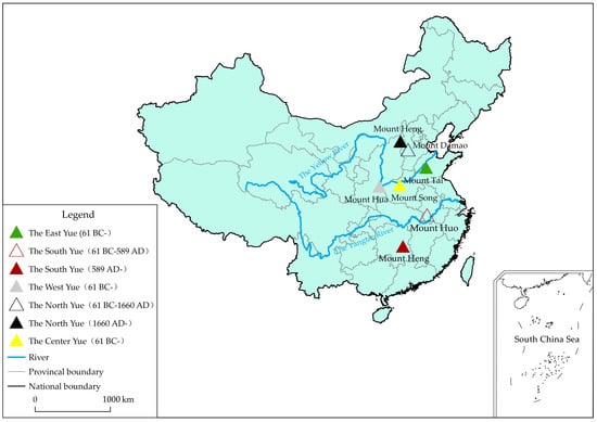
The above ancient books and imperial edicts show that the surface structure of the Wu Yue gradually became distinguishable from the Spring and Autumn Period and the Warring States period to the Western Han Dynasty. Figure 2 shows the location of each mountain of the five sacred mountains.
4.2. The Deep Structure of the Wu Yue
The analytical method of structuralist geography involves the examination of the binary opposition between the construction and reconstruction of geographic phenomena, such as the binary opposition between the real world and the imaginary world. The purpose of such analysis is to discover the underlying deep structure [51]. To explore the deep structure of the Wu Yue in China, we first must analyze the social background of the formation of the Wu Yue and determine the key problems of the historical period in which the Wu Yue originated.
The Warring States Period was a period of great division in China’s history, during which the governor of the Eastern Zhou Dynasty (770 BC to 256 BC) gradually lost control over many vassal states that had previously been granted some administrative rights. These vassal states developed and strengthened their own economic and military power and waged wars against other states to seize more land, almost entirely destroying the political and social order. Against this social backdrop, the statesmen, philosophers, and strategists of the time were all committed to formulating new ideas for constructing an orderly and harmonious society, among which the Five Elements Philosophy was the most representative.
The Five Elements Philosophy represents how ancient Chinese people perceived the natural and social environment during the Warring States Period. The Five Elements Philosophy considers that the world or the universe is composed of the movements and changes in form of five basic elements: wood, fire, earth, water, and metal. The five elements are associated with the five directions, five colors, five gods and other characteristics. Therefore, the world operates in a manner that is harmonious, orderly, and regular rather than unstable and chaotic. The Five Elements Philosophy exerted an important influence on Chinese architecture [52], medical science [53], and other fields. Naturally, it led to the emergence of the spatial arrangement of the Wu Yue.
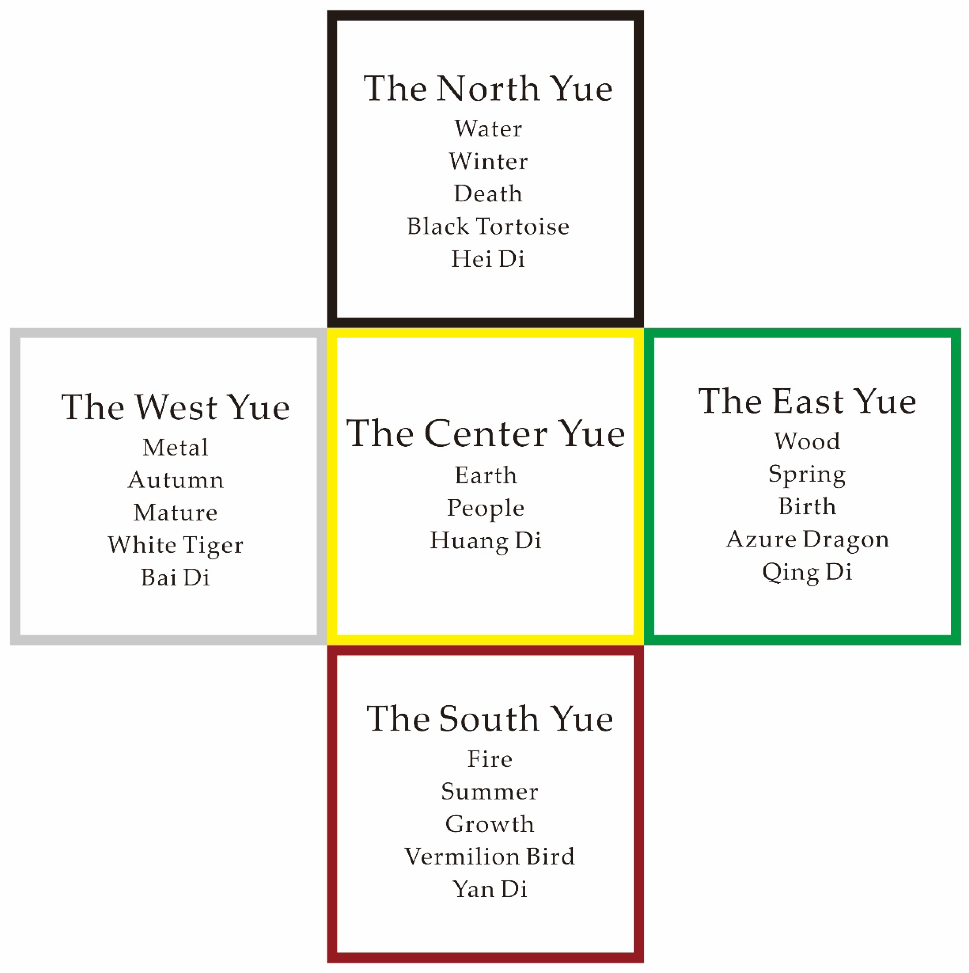
The Five Elements Philosophy is the deep structure of the Wu Yue that determines the surface structure of the Wu Yue. The East Yue, the South Yue, the West Yue, and the North Yue of the Wu Yue are located in the four directions and correspond to the four elements, colors, animals, and gods (see Figure 3). The ancient Chinese believed that each sacred mountain of the Wu Yue had supernatural power and played a role in maintaining the safety of the country’s territory. Therefore, the Wu Yue were also regarded as forming the symbolic boundary of the country’s territory. However, in contrast to the idea of the four sacred mountains of the Navajo, the Five Elements Philosophy further emphasizes the importance of the center of a territory. Therefore, from the perspective of this spatial order, the Center Yue has supreme symbolic status. Luoyang City, which is near Mount Song, the Center Yue, has a history of more than 1500 years as a capital city. Compared with other capital cities in ancient China, such as Xi’an, Kaifeng, Nanjing, Beijing, and Hangzhou, Louyang was chosen as the capital city by the emperors of thirteen dynasties because of its highly significant location.
The deep structure of the Wu Yue not only was approved by the Han regimes but also appealed to some ethnic minority regimes from northern China. When a northern ethnic minority moved from the north to the central part of China and took control of the entire country, this group had to learn the cultural traditions of the Han Chinese and absorb the essence of Han culture. For instance, the cultural value of the Wu Yue was a magnet for Emperor Xiaowen of the Northern Wei Dynasty (386 AD to 534 AD). The Northern Wei Dynasty was founded by the Xianbei people of the Tuoba tribe, who inhabited contemporary Northeast China for centuries. In 386 AD, Tuoba Gui, the leader of the Tuoba tribe, established a regime called Dai and chose Shengle City as the capital, which is now in Hohhot, the capital of the Inner Mongolia Autonomous Region. In 398 AD, Tuoba Gui changed the name of Dai to Northern Wei. Then, he relocated the capital to Pingcheng City, which is now in Datong City in North Shanxi Province. In 494 AD, Tuoba Hong, also known as Emperor Xiaowen, unexpectedly moved the capital from Pingcheng to Luoyang. This move was a major event in Chinese history. One of the reasons for relocating the capital was that the Northern Wei regime was outside the territory of the Wu Yue. According to the historical record The History of Wei, Emperor Xiaowen held a fierce debate with officials over the relocation of the capital. Although most of the officials strongly opposed the relocation, Emperor Xiaowen ignored their input. Emperor Xiaowen’s reason for the proposed relocation was that the capital of Pingcheng was beyond the northern boundary of China, which was marked by Mount Heng, the North Yue. In contrast, Luoyang was located in the center of China, adjacent to the Center Yue. As noted above, Luoyang has long been regarded as the heart of Chinese civilization. Before the Northern Wei regime moved its capital to Luoyang, it had been the capital of seven dynasties. Emperor Xiaowen clearly demonstrated his desire to establish the legitimacy of the Northern Wei regime in China. History proves that after Emperor Xiaowen moved the capital from Pingcheng to Luoyang, he strengthened his control and management of the country and made a tremendous contribution to integrating the Xianbei people and the Han people.
4.3. Varying Surface Structure and Constant Deep Structure
From the Western Han Dynasty (202 BC to 9 AD) to the Sui Dynasty (581 AD to 618 AD), the surface structure of the Wu Yue was relatively stable. However, with the expansion of the territory of ancient China, the Wu Yue could not symbolically surround the entire territory. Therefore, the emperors relocated the physical entities of the Wu Yue.
The first change was the relocation of the South Yue in the Sui Dynasty. During the Western Han Dynasty, the political and economic center of China was mainly in the middle and lower reaches of the Yellow River, which were regarded as the heartland of Chinese civilization at that time, as the area of the Yangtze River had not been fully developed. However, before the Sui Dynasty, many wars occurred in the northern part of China over a long period of time that caused severe damage to the development of the region. In contrast, the southern part was relatively peaceful, and people in northern China migrated to the south to escape the wars. They brought advanced technology and sufficient labor for agriculture in the southern region that contributed to the population growth and economic development of the area. After Emperor Wen of the Sui Dynasty again achieved reunification of the country, he found that the southern territories had far exceeded the traditional southern boundary, which was marked by Mount Huo and located on the northern side of the Yangtze River (see Figure 2). Therefore, Mount Huo as the South Yue had lost its role as the protecting god of the south. In 589 AD, Emperor Wen of the Sui Dynasty changed the South Yue from Mount Huo to Mount Heng in Hunnan Province. This historical event shows that in Chinese mountain culture, the South Yue is not necessarily fixed as a certain mountain but can change as territory expands.
The second change was the relocation of the North Yue. Figure 2 shows that there are two North Yue: Mount Heng in Shanxi Province and Mount Damao in Hebei Province. The earliest historical record of the North Yue is found in the book The Rites of Zhou, which only mentions that the North Yue is in Bing Prefecture, omitting the geographic name of the mountain. In the pre-Qin Dynasty period (before 221 BC), Bing Prefecture generally included the entire territory of contemporary Shanxi Province and parts of the two cities of Baoding and Shijiazhuang in contemporary Hebei Province. Therefore, it is not clear exactly where the North Yue was located. Shih Chi is the earliest ancient book recording that the North Yue was Mount Chang, also called Mount Damao. Dream Pool Essays, written during 1086–1093, recorded that the North Yue is Mount Damao, 70 km northwest of contemporary Quyang County, Hebei Province.
However, from the Jin Dynasty (1115 AD to 1234 AD) to the Qing Dynasty (1636 AD to 1912 AD), there were some proposals to name Mount Heng in Hunyuan County, Shanxi Province, instead of Mount Damao in Quyang County, Hebei Province, as the North Yue. Some officials in the Jin Dynasty suggested selecting another mountain north of the capital (contemporary Beijing) as the North Yue because the capital was located north of Mount Damao and was outside the region symbolically and geographically surrounded by the Wu Yue. However, that proposal was not implemented. In the early Ming Dynasty (1368 AD to 1644 AD), Hunyuan County in Shanxi Province began to compete with Quyang County, Hebei Province, over possession of the North Yue. Due to the military incursions of northern nomads in the Ming Dynasty, Hunyuan played an important role in military defense. Therefore, the view that the geographical entity of the North Yue was in Hunyuan was strongly supported by military officials. Moreover, an increasing number of people had accepted the North Yue in Hunyuan County by the late Ming Dynasty. For example, Xiake Xu’s Travel Notes records that the geographical entity of the North Yue is in Hunyuan [54]. In 1660 AD, Emperor Shunzhi of the Qing Dynasty completely resolved the dispute over the location of the North Yue, declaring that worship at the North Yue would be changed to Hunyuan County. Since then, it has been agreed that the location of the North Yue is in Hunyuan County rather than Quyang County.
Changes in the geographic entities of the South Yue and North Yue show the unique cultural value of the Wu Yue. On the one hand, the surface structure of the Wu Yue can be flexibly adjusted according to changes in territory either to cover the entire country’s territory symbolically or to ensure that the capital is geographically located within the Wu Yue. On the other hand, no matter how the surface structure is adjusted, each mountain of the Wu Yue is almost always located in the five cardinal directions of the territory in accordance with the deep structure of the Five Elements Philosophy, which was passed down from generation to generation in ancient China. In this sense, it is the deep structure that has kept the Wu Yue sustainable for more than two thousand years.
5. The Semiotic Analysis
In this section, we draw upon the semiotic approach to explore the signifier and the signified of the Wu Yue. According to the information recorded in ancient books, we discuss the sign of the Wu Yue in terms of three main levels (see Table 1).
5.1. The First Level of the Sign of the Wu Yue
At the first level in Table 1, the sign of a sacred mountain usually consists of a physical mountain (signified) and a mountain’s name (signifier). For example, historically, the North Yue of Mount Heng had several geographic names, including Mount Taiheng–the word Tai in Chinese means large, so people use the name Mount Taiheng to imply the majesty of Mount Heng; Mount Xuanwu–Xuanwu refers to a black tortoise, which is a mythical creature inhabiting Mount Heng; and Mount Gaoshi–Mount Gaoshi is a mysterious mountain in the ancient book Mountain and Sea Classics. In addition, Mount Tai is also known as Mount Dai, for that the Chinese characters Dai and Tai have the same meaning–peace.
5.2. The Second Level of the Sign of the Wu Yue
In the Western Han Dynasty, the second level of the sign of the Wu Yue emerged. When Emperor Xuan of the Western Han Dynasty designated the geographical entities of the Wu Yue in an imperial edict, the signifier approved by the emperor and the public became the Wu Yue rather than the five sacred mountain names. The sign of the Wu Yue therefore reached the second level shown in Table 1. The implication is that in people’s minds, the East Yue, South Yue, West Yue, North Yue, and Center Yue are more significant than their original mountain names.
More importantly, at the second level, the name of the Wu Yue is the signifier linked to the meanings of those sacred mountains as the signified, such as the basic elements, colors, seasons, gods and magical animals, which are shown in Figure 3. We found references in two ancient books to the signified of the Wu Yue. The first is in Fengsu Tongyi, which was published in the Eastern Han Dynasty (25 AD to 220 AD). The second is in Zhenzhongshu, an essay published in the Eastern Jin Dynasty (317 AD to 420 AD). According to these two texts, the nature of the East Yue of Mount Tai is wood, corresponding to spring and the color green; the main god is Qing Di with his mythical animal, called the Azure Dragon. Qing Di dominates the creation of all things. The nature of the South Yue of Mount Heng is fire, corresponding to summer and the color red; the main god is Yan Di with his mythical animal, the Vermillion Bird. Yan Di dominates the growth of all things. The nature of the West Yue of Mount Hua is metal, corresponding to autumn and the color white; the main god is Bai Di with his mythical animal, the White Tiger. Bai Di dominates the maturation of all things. The nature of the North Yue of Mount Heng is water, corresponding to winter and the color black; the main god is Hei Di with his mythical animal, the Black Tortoise. Hei Di dominates the death of all things. The Center Yue of Mount Song is seated in the center of the spatial pattern. Its nature is earth, and the main god is Huang Di, who dominates the entire world.
5.3. The Third Level of the Sign of the Wu Yue
The acceptance of the Wu Yue by some political powers surrounding China showed that the sign system of the Wu Yue reached the third level shown in Table 1. On historical maps of China, some political powers are distributed around the central part of China; therefore, most of them were unable to place their territory within the Wu Yue. However, following the spatial pattern of the Wu Yue used in Han cultures, these powers constructed their own Wu Yue in their own territories. In this respect, the spatial pattern of the Wu Yue is the signifier, and the philosophy of the Wu Yue is the signified.
One neighboring political power that appreciated and inherited the cultural value of the Wu Yue was the Nanzhao regime, which governed the area of Erhai Lake in contemporary Yunnan Province from 738 AD to 902 AD. Influenced by the Wu Yue in the Western Han Dynasty, Mouxun Yi, the sixth emperor of the Nanzhao Kingdom, also named five sacred mountains in the territory of the Nanzhao regime in 784 AD: Mount Wumeng as the East Yue, Mount Mengyue as the South Yue, Mount Gaoligong as the West Yue, Mount Yulong as the North Yue and Mount Cang as the Center Yue. Mouxun Yi established temples at each mountain, constructed a ritual system for the Wu Yue and regularly held sacrifices to pray for the security and prosperity of the Nanzhao regime.
Another political power, identifying with the cultural meaning of the Wu Yue, was the kingdom of Silla (57 AD to 935 AD) on the Korean Peninsula. King Munmu of Silla borrowed from the Chinese concept of the Wu Yue when he came into power to build a sacred and orderly space. The Wu Yue on the Korean Peninsula are composed of Toham-san as the East Yue, Gyeryong-san as the West Yue, Jiri-san as the South Yue, Taebaek-san as the North Yue, and Palgong-san as the Center Yue. Interestingly, the physical entities of the Wu Yue on the Korean Peninsula also changed during the Yi Dynasty of Joseon (1392 to 1910), when Kumgang-san was the East Yue, Myohyang-san was the West Yue, Jiri-san was the South Yue, Paektu-san was the North Yue, and Samgak-san was the Center Yue.
Therefore, it is the third level of the sign that distinguishes the Wu Yue from other sacred mountains around the world, is identified by people within a larger geographical area and is inherited over many generations. Even in modern society, the signifier and the signified of the Wu Yue at the third level are still inherited by some social and cultural groups in China. In 1971, the Taiwan Mountaineering Association created a list of 100 peaks taller than 3000 m on Taiwan Island for mountaineering, five of which were selected to make up the Wu Yue on the island, including Mount Luan as the East Yue, Mount Nanhu as the South Yue, Mount Xue as the West Yue, Mount Dawu as the North Yue, and Mount Yu as the Center Yue. In Jinan City, Shandong Province, local people selected five mountains according to the spatial pattern of the Wu Yue and the Five Elements Philosophy to constitute their own Wu Yue, called the Little Wu Yue, involving Mount Qianfo, Mount Fohui, Mount Youyan, Mount Pingding, and Mount Jiling.
6. Conclusions and Discussion
6.1. Conclusions
Since the United Nations Conference on Environment and Development in 1992, the sustainability of mountains has acquired global recognition [55]. This article mainly focuses on the sustainability of mountains in the cultural dimension. We offer the approaches of structuralist geography and semiotics to examine the inheritance mechanism of the Wu Yue in China from a dynamic rather than a static perspective. Two major conclusions are drawn, as follows.
First, based on the approach of structural geography, the spatial pattern of the Wu Yue can be viewed as a surface structure that is determined by a deep structure, the Five Elements Philosophy. Notwithstanding the relocation of the South Yue and the North Yue, the deep structure of the Five Elements Philosophy is fairly stable and can be regarded as the inheritance mechanism of the Wu Yue. We then proceeded to a poststructuralist analysis. Since poststructuralism breaks the original structure, a broken surface structure may be a manifestation of poststructuralism. The location changes of the North Yue and the South Yue in Chinese history broke the original surface spatial structure of the Wu Yue. Therefore, these changes can be regarded as a poststructuralist phenomenon. However, the deep structure of the spatial structure of the Wu Yue was always based on the Five Elements Philosophy, which was key to the cultural sustainability of the Wu Yue. Thus, we argue that, in the case of the Wu Yue, poststructuralism has limited potential to interpret the cultural sustainability of sacred mountains.
Second, based on the semiotic approach, the sign of a sacred mountain usually consists of the physical mountain (signified) and its name (signifier), which is the first level of the sign of the Wu Yue. However, the sign of the Wu Yue is more complex because it has a second and a third level. At the second level, the signifier of the Wu Yue is the sacred mountain’s name in the Wu Yue system (the East Yue, the South Yue, the West Yue, the North Yue and the Center Yue); the signified is the place of a god and the category of his power. At the third level, the signifier is the spatial pattern of the Wu Yue; the signified is the Five Elements Philosophy. The variations in the sign of the Wu Yue can be explained by poststructuralism. However, it is the third level as a structural power that endows the Wu Yue with unique value and sustainability and shows the limitation of poststructuralism in analyzing the inheritance mechanism of the Wu Yue.
6.2. Discussion
Thus far, we have interpreted the sustainability of the Wu Yue in ancient China. Is the inheritance mechanism of the Wu Yue that has operated throughout history still in effect? How do people conserve the Wu Yue in contemporary China? To answer the above questions, two issues deserve to be discussed.
One issue refers to the multi-religion situation in China. All the religions in China have equal rights that are protected by the constitution of China. Religiously, the Wu Yue are a symbol of the Taoist culture. Do the Wu Yue conflict with other religious sacred mountains? Are they unacceptable to the adherents of other religions? Perry Schmidt-Leukel, a scholar of Chinese religion, argued that most religions in China were in harmony with each other because of the strong control exercised by the ruling authorities and the Chinese traditional idea of ‘harmony but not sameness’ [56]. These concepts can explain why the sign of the Wu Yue remained sustainable despite the diverse religious cultures in ancient China. First, beginning in ancient times, Chinese emperors endowed the Wu Yue with the highest status. Second, the Five Elements Philosophy emphasizes peace and harmony according to the idea of ‘harmony but not sameness’.
Another issue concerns the conflict between the two goals of economic development and the protection of sacred mountains’ sacredness. Because of economic development, the total amount of natural resources obtained from mountains in ancient China was much less than it is today. Therefore, when economic goals conflict with the conservation of sacred mountains’ sacredness, people must choose between development and conservation. In India, when some companies wanted to mine high-quality bauxite at Niyamgiri for economic reasons, the local people rose up in opposition. However, compared with the power of capital, the power of the grassroots movement was so weak that these appeals were ignored [57]. Today, many sacred mountains around the world are involved in similar situations. How will people address such conflicts if they arise with respect to the mountains of the Wu Yue? It is not clear whether there is a better way of choosing another mountain as a new Yue if people care more about the spatial pattern than the location of a mountain. Moreover, most sacred mountains are tourist destinations today, and tourists with different cultural backgrounds usually have various images of the sacred mountains [58]. Is it necessary for the managers and planners of the Wu Yue to change the landscape to meet tourists’ expectations? This issue is another challenge related to the sustainability of the Wu Yue.
Author Contributions
S.Z. wrote the major parts of the paper. W.X. collected the original historical materials, wrote some parts of the paper, and drew the figures. Both the authors contributed to the conceptual framework.
Acknowledgments
This study was jointly supported by the National Natural Science Foundation of China (41771148) and the Major Project of National Philosophy and Social Science Foundation of China (14ZDB139). We would like to thank Professor Stanley Brunn for his insightful comments and language polishing.
Conflicts of Interest
The authors declare no conflict of interest.
Appendix A

| Title of the Ancient Book | Author | Publication Date | Main Information | Link | |
|---|---|---|---|---|---|
| 1 | Book of Documents | Unknown | The Warring States Period (475 BC to 221 BC) | The Si Yue consisted of the East, South, West and North Yue. Though the location of the East Yue is mentioned, the locations of the other three sacred mountains are not. | http://103.242.200.9/ancientbook/portal/readPage/28701860C29B4BFFB5DAC6F3C12D9EDA/9/index.do?heightWord=%25E5 |
| 2 | The Rites of Zhou | Unknown | The Warring States Period (475 BC to 221 BC) | The Wu Yue had supreme status and authority among the sacred mountains in China at that time. | http://103.242.200.9/ancientbook/portal/readPage/A632DB10DBDE4FA5B425DDE4B55619AB/242/index.do?heightWord=%25E5 |
| 3 | The Rites of Zhou | Unknown | The Warring States Period (475 BC to 221 BC) | The North Yue was in Bing Prefecture, but the geographic name of the North Yue is not mentioned. | http://103.242.200.9/ancientbook/portal/readPage/5665E32920CF4D4BA89F28381027B97D/323/index.do?heightWord=%25E6 |
| 4 | The Book of Rites | Unknown | The Warring States Period (475 BC to 221 BC) | The Wu Yue had the power to stabilize the entire country. | http://103.242.200.9/ancientbook/portal/readPage/C690DA82DA374B999C9C0485B62A0DD2/84/index.do?heightWord=%25E5 |
| 5 | Shih Chi | Maqian Si | The Western Han Dynasty (202 BC to 9 AD) | The First Emperor of Qin divided nine sacred mountains around the country into the eastern group and the western group after he unified China in 221 BC. | http://103.242.200.9/ancientbook/portal/readPage/2BAAFDC81FE9453D95FFD0E662483E1A/636/index.do?heightWord=%25E6 |
| 6 | Shih Chi | Maqian Si | The Western Han Dynasty (202 BC to 9 AD) | The North Yue was Mount Chang, also called Mount Damao | http://103.242.200.9/ancientbook/portal/readPage/D6FB8F2FA8D84EC8AC6711B8A8B89FCB/68/index.do?heightWord=%25E5%25B8%25B8%25E5%25B1%25B1 |
| 7 | Book of Han | Gu Ban | The Eastern Han Dynasty (25 AD to 220 AD) | In 61 BC, Emperor Xuan of the Western Han Dynasty claimed the geographical entities of the Wu Yue in an imperial edict. | http://103.242.200.9/ancientbook/portal/readPage/932AD2B5A280426B94C001592E7529DF/812/index.do?heightWord=%25E4 |
| 8 | Fengsu Tongyi | Zhao Ying | The Eastern Han Dynasty (25 AD to 220 AD) | The basic elements, colors, seasons, and magical animals associated with each sacred mountain of the Wu Yue. | http://103.242.200.9/ancientbook/portal/readPage/4B429A98C14443F5B0E654E0901CEC91/121/index.do?heightWord=%25E5 |
| 9 | Zhenzhongshu | Hong Ge | The Eastern Jin Dynasty (25 AD to 220 AD) | The gods inhabiting each sacred mountain of the Wu Yue. | http://103.242.200.9/ancientbook/portal/readPage/C8E0D0B1A3A149068B56BA713F1C1307/6/index.do?heightWord=%25E5 |
| 10 | The History of Wei | Shou Wei | The Northern and Southern Dynasties (420 AD to 589 AD) | Emperor Xiaowen of the Northern Wei Dynasty proposed to move the capital from Pingcheng City to Luoyang City because the former was outside the sacred space of the Wu Yue. | http://103.242.200.9/ancientbook/portal/readPage/1468C317887547E0B46172148BC8BEB6/215/index.do?heightWord=%25E4 |
| 11 | Dream Pool Essays | Kuo Shen | The Northern Song Dynasty (960 AD to 1127 AD) | Mount Damao is the North Yue. | http://103.242.200.9/ancientbook/portal/readPage/6B02919DDCBB475397613823584A3D52/284/index.do?heightWord=%25E5 |
| 12 | Jin History | Tuo Tuo | The Ming Dynasty (1368 AD to 1644 AD) | Some officials proposed to select another mountain north of the capital (contemporary Beijing) as the North Yue to place the capital inside the sacred space of the Wu Yue. | http://103.242.200.9/ancientbook/portal/readPage/E11D0489D64744708B57EEF382C4BEF3/1159/index.do?heightWord=%25E5 |
| 13 | Hunyuan Local Chronicles | Jingshun Gui | The Qing Dynasty (1636 AD to 1912 AD) | In 1660 AD, the Qing government officially declared that the location of the North Yue was in Hunyuan County rather Quyang County. | http://103.242.200.9/ancientbook/portal/readPage/53123B063F4844C29404DCD463DA89CF/70/index.do?heightWord=%25E6 |
| 14 | Dushi Fangyu Jiyao | Zuyu Gu | The Qing Dynasty (1636 AD to 1912 AD) | In 589 AD, Emperor Wen of the Sui Dynasty named Mount Heng in Hunnan Province instead of Mount Huo as the South Yue. | http://103.242.200.9/ancientbook/portal/readPage/2CE526F54A3C407E80407895D9BE5C08/3675/index.do?heightWord=%25E5%258D%2597%25E5%25B2%25B3 |
References
- Bernbaum, E. Sacred Mountains of the World; University of California Press: Berkeley, CA, USA, 1997; ISBN 0520214226. [Google Scholar]
- Bernbaum, E. Sacred mountains: Themes and teachings. Mt. Res. Dev. 2006, 26, 304–309. [Google Scholar] [CrossRef]
- Dora, V.D. Alexander the great’s mountain. Geogr. Rev. 2010, 95, 489–516. [Google Scholar] [CrossRef]
- Mazumdar, S.; Mazumdar, S. Sacred space and place attachment. J. Environ. Psychol. 1993, 13, 231–242. [Google Scholar] [CrossRef] [Green Version]
- Bernbaum, E. The spiritual and cultural significance of mountains. In Mountains of the World. A Global Priority; Ives, J.D., Messerli, B., Eds.; The Parthenon Publishing Group: NewYork, NY, USA, 1997; pp. 39–60. ISBN 1-85070-781-2. [Google Scholar]
- Thorsell, J. A Global overview of mountain protected areas on the world heritage list. Mt. Res. Dev. 2003, 23, 291. [Google Scholar] [CrossRef]
- Marston, R.A. Land, life, and environmental change in mountains. Ann. Assoc. Am. Geogr. 2008, 98, 507–520. [Google Scholar] [CrossRef]
- Burton, P.J. Striving for sustainability and resilience in the face of unprecedented change: The case of the mountain pine beetle outbreak in British Columbia. Sustainability 2010, 2, 2403–2423. [Google Scholar] [CrossRef]
- Tanner, T. Peopling mountain environments: Changing Andean livelihoods in North-West Argentina. Geogr. J. 2003, 169, 205–214. [Google Scholar] [CrossRef]
- Olsen, C.S.; Larsen, H.O. Alpine medicinal plant trade and Himalayan mountain livelihood strategies. Geogr. J. 2003, 169, 243–254. [Google Scholar] [CrossRef]
- Huber, F.K.; Morlok, M.; Weckerle, C.S.; Seeland, K. Livelihood strategies in Shaxi, Southwest China: Conceptualizing mountain-valley interactions as a human-environment system. Sustainability 2015, 7, 3204–3229. [Google Scholar] [CrossRef] [Green Version]
- Fnnell, D.C.; Price, M.F. Mountain geography: A review. Geogr. J. 2003, 169, 183–190. [Google Scholar] [CrossRef]
- Smethurst, D. Mountain geography. Geogr. Rev. 2000, 90, 35–56. [Google Scholar] [CrossRef]
- Fonstad, M. Mountains: A special issue. Ann. Assoc. Am. Geogr. 2017, 107, 235–237. [Google Scholar] [CrossRef]
- Hinde, R. Interactions, relationships and social structure. Man 1976, 11, 1–17. [Google Scholar] [CrossRef]
- Gregory, D.; Johnston, R.; Pratt, G.; Watts, M.; Whatmore, S. The Dictionary of Human Geography, 5th ed.; Blackwell Publishing: London, UK, 2009; p. 725. ISBN 978-1-4051-3287-9. [Google Scholar]
- Wilson, N.G. Encyclopedia of Ancient Greece; Routledge: London, UK, 2006; ISBN 0415973341. [Google Scholar]
- Kenyatta, J. Facing Mount Kenya; Vintage Books: New York, NY, USA, 1962; ISBN 9780394702100. [Google Scholar]
- Ceruti, C. Human bodies as objects of dedication at Inca Mountain shrines (north-western Argentina). World Archaeol. 2004, 36, 103–122. [Google Scholar] [CrossRef]
- Mabbett, I.W. The symbolism of mount Meru. Hist. Relig. 1983, 23, 64–83. [Google Scholar] [CrossRef]
- Wright, J. Four symbolic boundaries of the American West. Geogr. Rev. 2014, 104, 229–241. [Google Scholar] [CrossRef]
- Ball, M. Sacred mountains, religious paradigms, and identity among the Mescalero Apache. World Views Environ. Cult. Relig. 2000, 4, 264–282. [Google Scholar] [CrossRef]
- Blake, K.S. In search of a Navajo sacred geography. Geogr. Rev. 2001, 91, 715–724. [Google Scholar] [CrossRef]
- Griffin-Pierce, T. “When I am lonely the mountains call me”: The impact of sacred geography on Navajo psychological well-being. Am. Indian Alsk. Native Ment. Health Res. 1997, 7, 1–10. [Google Scholar] [CrossRef] [PubMed]
- Mcguire, M.P. What’s at stake in designating Japan’s sacred mountains as UNESCO world heritage sites? Shugendo practices in the Kii Peninsula. Jpn. J. Relig. Stud. 2013, 40, 323–354. [Google Scholar] [CrossRef]
- Lane, B. The Solace of Fierce Landscapes: Exploring Desert and Mountain Spirituality; Oxford University Press: New York, NY, USA, 1998; ISBN 9780195315851. [Google Scholar]
- Henderson, K.A. World religions, spirituality, and experiential education. J. Exp. Educ. 2000, 23, 128–134. [Google Scholar] [CrossRef]
- Sauer, C.O. The morphology of the landscape. In Human Geography: An Essential Anthology; Agnew, J., Livingstone, D.N., Rogers, A., Eds.; Blackwell Publishing: London, UK, 1996; pp. 296–315. ISBN 0631194592. [Google Scholar]
- Greider, T.; Garkovich, L. Landscapes: The social construction of nature and the environment. Rural Sociol. 1994, 59, 1–24. [Google Scholar] [CrossRef]
- Harrison, P. Poststructuralist Theories. In Approaches to Human Geography; Aitken, S., Valentine, K., Eds.; SAGE Publications: London, UK, 2006; pp. 122–135. ISBN 0761942637. [Google Scholar]
- Schmidt-Leukel, P. Buddhism and Religious Diversity; Routledge: London, UK, 2012; ISBN 9780415525343. [Google Scholar]
- Saussure, F.D. Course in General Linguistics; McGraw-Hill: New York, NY, USA, 1965; ISBN 9780070165243. [Google Scholar]
- Peirce, C.S.; Hartshorne, C.; Weiss, P.; Burks, A.W. Collected Papers of Charles Sanders Peirce; Thoemmes Continuum: Bristol, UK, 1994; ISBN 9781855065567. [Google Scholar]
- Chandler, D. Semiotics: The Basics; Routledge: London, UK, 2002; p. 19. ISBN 0415265932. [Google Scholar]
- Longhurst, B.; Smith, G.; Bagnall, G.; Crawford, G.; Ogborn, M.; Baldwin, E.; McCracken, S. Introducing Cultural Studies; Pearson: Harlow, UK, 2008; p. 29. ISBN 1405858435. [Google Scholar]
- Blue, B.; Brierley, G. ‘But what do you measure?’ prospects for a constructive critical physical geography. Area 2016, 48, 190–197. [Google Scholar] [CrossRef]
- Cosgrove, D.E. Social Formation and Symbolic Landscape; Croom Helm: London, UK, 1984; ISBN 9780389205401. [Google Scholar]
- Aase, T.H. Symbolic space: Representations of space in geography and anthropology. Geogr. Ann. 1994, 76, 51–58. [Google Scholar] [CrossRef]
- Meinig, D.W. The Interpretation of Ordinary Landscapes: Geographical Essays; Oxford University Press: New York, NY, USA, 1979; ISBN 9780195025361. [Google Scholar]
- Blake, K.S. Peaks of identity in Colorado’s San Juan Mountains. Int. J. Cult. Geogr. 1999, 18, 29–55. [Google Scholar] [CrossRef]
- Alexander, J.C. Iconic consciousness: The material feeling of meaning. Environ. Plan. D Soc. Space 2008, 26, 782–794. [Google Scholar] [CrossRef]
- Tuan, Y.F. Topophilia: A Study of Environmental Perceptions, Attitudes, and Values; Columbia University Press: New York, NY, USA, 1990; ISBN 0231073941. [Google Scholar]
- Tuan, Y.F. Space and Place: The Perspective of Experience; University of Minnesota Press: Minneapolis, MN, USA, 1977; ISBN 0816638772. [Google Scholar]
- Nicolson, M.H. Mountain Gloom and Mountain Glory: The Development of the Aesthetics of the Infinite; University of Washington: Seattle, WA, USA, 1996; ISBN 0295975776. [Google Scholar]
- Cosgrove, D.E.; Dora, V.D. High Places: Cultural Geographies of Mountains and Ice; Tauris Books: London, UK, 2008; ISBN 1845116178. [Google Scholar]
- Zwoliński, Z.; Hildebrandt-Radke, I.; Mazurek, M.; Makohonienko, M. Existing and proposed urban geosites values resulting from geodiversity of Poznań City. Quaest. Geogr. 2017, 36, 125–149. [Google Scholar] [CrossRef]
- Prasithrathsint, A. Principles of Thai place-name formation: A reflection of natural and cultural heritage. Int. J. Sociol. Lang. 2007, 186, 59–73. [Google Scholar] [CrossRef]
- Gibson-Graham, J.K. Poststructural interventions. In Companion to Economic Geography; Sheppard, E., Barnes, T., Eds.; Blackwell Publishing: London, UK, 2000; pp. 95–110. ISBN 063121223X. [Google Scholar]
- Macfarlane, R. Mountains of the Mind: A History of A Fascination; Granta Books: London, UK, 2004; ISBN 9781847080394. [Google Scholar]
- Blake, K.S. Review essay: Mountain symbolism and geographical imaginations. Cult. Geogr. 2005, 12, 527–531. [Google Scholar] [CrossRef]
- Baker, A.R.H. Historical geography. Prog. Hum. Geogr. 1977, 1, 465–474. [Google Scholar] [CrossRef]
- Chen, X.; Wu, J. Sustainable landscape architecture: Implications of the Chinese philosophy of ‘unity of man with nature’ and beyond. Landsc. Ecol. 2009, 24, 1015–1026. [Google Scholar] [CrossRef]
- Hicks, A.; Hicks, J.; Mole, P. Five Element Constitutional Acupuncture; Churchill Livingstone: New York, NY, USA, 2004; ISBN 9780443071706. [Google Scholar]
- Xu, X. Xiake Xu’s Travel Notes (In Chinese); Zhonghua Book Company: Beijing, China, 2009; pp. 56–59. ISBN 9787101063981. [Google Scholar]
- Bernard, D.; Martin, F. Representing mountains: From local and national to global common good. Geopolitics 2008, 13, 148–168. [Google Scholar]
- Schmidt-Leukel, P.; Gentz, J. Religious Diversity in Chinese Thought; Palgrave Macmillan: London, UK, 2013; ISBN 9781137333193. [Google Scholar]
- Kundan, K. The sacred mountain: Confronting global capital at Niyamgiri. Geoforum 2014, 54, 196–206. [Google Scholar]
- Wong, C.U.I.; McIntosh, A.; Ryan, C. Buddhism and tourism: Perceptions of the Monastic community at Pu-Tuo-Shan, China. Ann. Tour. Res. 2013, 40, 213–234. [Google Scholar] [CrossRef]
Figure 1.
Photos of each mountain in the Wu Yue system at present. (a) The East Yue, Mount Tai; (b) the South Yue, Mount Heng; (c) the West Yue, Mount Hua; (d) the North Yue, Mount Heng; and (e) the Center Yue, Mount Song.
Figure 1.
Photos of each mountain in the Wu Yue system at present. (a) The East Yue, Mount Tai; (b) the South Yue, Mount Heng; (c) the West Yue, Mount Hua; (d) the North Yue, Mount Heng; and (e) the Center Yue, Mount Song.

Figure 2.
The Locations of the Wu Yue in China.

Figure 3.
The Five Elements Philosophy and the Wu Yue. (Sources of this interpretation: two ancient books, Fengsu Tongyi and Zhenzhongshu).
Figure 3.
The Five Elements Philosophy and the Wu Yue. (Sources of this interpretation: two ancient books, Fengsu Tongyi and Zhenzhongshu).

Table 1.
The three levels of the sign of the Wu Yue.
| Level | 1st | 2nd | 3rd |
|---|---|---|---|
| Signifier | Original name of the mountain | Sacred mountain’s name in the Wu Yue (East Yue, South Yue, West Yue, North Yue and Center Yue) | The spatial pattern of the Wu Yue |
| Signified | Entity of the mountain | The place of a god and the category of his power (see Figure 3) | The Five Elements Philosophy |
© 2018 by the authors. Licensee MDPI, Basel, Switzerland. This article is an open access article distributed under the terms and conditions of the Creative Commons Attribution (CC BY) license (http://creativecommons.org/licenses/by/4.0/).
Share and Cite
MDPI and ACS Style
Zhou, S.; Xu, W. Interpreting the Inheritance Mechanism of the Wu Yue Sacred Mountains in China Using Structuralist and Semiotic Approaches. Sustainability 2018, 10, 2127. https://doi.org/10.3390/su10072127
AMA Style
Zhou S, Xu W. Interpreting the Inheritance Mechanism of the Wu Yue Sacred Mountains in China Using Structuralist and Semiotic Approaches. Sustainability. 2018; 10(7):2127. https://doi.org/10.3390/su10072127
Chicago/Turabian StyleZhou, Shangyi, and Weilin Xu. 2018. "Interpreting the Inheritance Mechanism of the Wu Yue Sacred Mountains in China Using Structuralist and Semiotic Approaches" Sustainability 10, no. 7: 2127. https://doi.org/10.3390/su10072127
Note that from the first issue of 2016, this journal uses article numbers instead of page numbers. See further details here.