Article

Influence of Stone Bunds on Vegetation and Soil in an Area Reforested with Pinus engelmannii Carr. in the Forests of Durango, Mexico

by
Ma. del Carmen Ponce-Rodríguez
1,
José Ángel Prieto-Ruíz
2,*,
Francisco Oscar Carrete-Carreón
3,
María Elena Pérez-López
4,
José de Jesús Muñoz-Ramos
5,
Osvaldo Reyes-Estrada
3 and
Héctor Ramírez-Garduño
6
1
Programa Institucional de Doctorado en Ciencias Agropecuarias y Forestales, Universidad Juárez del Estado de Durango, Constitución 404 sur Zona Centro, Durango CP 34000, Mexico
2
Facultad de Ciencias Forestales, Universidad Juárez del Estado de Durango, Río Papaloapan y Boulevard, Durango S/N Col. Valle del Sur, Durango CP 34120, Mexico
3
Facultad de Medicina Veterinaria y Zootecnia, Universidad Juárez del Estado de Durango, Carretera Durango-Mezquital, Km 11.5, Durango CP 34307, Mexico
4
Instituto Politécnico Nacional-Centro Interdisciplinario de Investigación para el Desarrollo Integral Regional Durango, Sigma 119, Fraccionamiento 20 de Noviembre II, Durango CP 34220, Mexico
5
Instituto Tecnológico del Valle del Guadiana, Carretera Durango-México Km 22.5 s/n, Durango CP 34371, Mexico
6
Instituto Nacional de Investigaciones Forestales, Agrícolas y Pecuarias-Centro de Investigación Regional Norte, Carretera Chihuahua-Ojinaga Km 33.3, Aldama, Chihuahua CP 32910, Mexico
*
Author to whom correspondence should be addressed.
Sustainability 2019, 11(18), 5033; https://doi.org/10.3390/su11185033
Submission received: 30 July 2019 / Revised: 7 September 2019 / Accepted: 10 September 2019 / Published: 14 September 2019

Abstract

:
The forest ecosystems of Mexico experience soil degradation mainly due to water erosion, which causes low vegetation regeneration. One of the strategies to diminish soil loss is through the construction of stone bunds (SB)—hand-made structures to trap sediment and store water for longer periods. However, little is known about their effects on pine establishment. The objectives of this study were to evaluate the effect of SB on the survival and growth of individual P. engelmannii Carr. specimens with respect to the distance of their planted. The study additionally sought to analyse how SB would affect changes in the production of aerial phytomass, herbaceous vegetation cover and soil characteristics in a reforested area of Durango State in north-central Mexico. Three treatments were evaluated by planting pine trees at three distances with respect to the SB: 80 cm upslope bund (UB), 80 cm downslope bund (DB) and between upper and lower bunds (BB). The variables analysed were the following: The survival and growth of reforestation, aerial coverage and the production of herbaceous plants, and the physicochemical characteristics of the soil. Survival showed significant differences (p < 0.05) among treatments, UB (80%), DB (27%) and BB (30%). The production of aerial phytomass did not show significant differences between treatments UB (1651 kg ha−1) and DB (1058 kg ha−1), although these two were different (p < 0.05) to BB (600 kg ha−1). On the other hand, the vegetation cover and soil characteristics did not show statistical differences. These results highlight the importance of the effect of SB on the survival of P. engelmannii Carr. and the growth of herbaceous vegetation.

Graphical Abstract

1. Introduction

Around the world, 33% of the surface is experiencing some level of degradation. Erosion is the main factor in soil deterioration and each year 25 to 40 billion tons of soil is lost. The main causal agents are wind and water—with water erosion causing the most damage [1].
When erosion occurs, the soil undergoes a gradual decrease in productivity due to the loss of nutrients through the transportation of fine particles and organic matter [2]. This process modifies the physical structure of the soil, whereby the surface is sealed and crusts are formed, which results in a lessening of water infiltration and, consequently, drainage becomes faster [3,4]. However, there are other factors that influence infiltration, such as the intensity and duration of rain, soil texture and the moisture content of the soil [5]. Overgrazing is a determining factor in soil erosion, increasing soil compaction due to trampling by cattle, thus limiting water infiltration and the establishment of vegetation [6]. As a result of the above factors, the desirable species, timber and forage, decrease their vigour and productive capacity, and they are replaced by others of lower interest, yield and nutritional value [7]. The effects of erosion are linked to desertification and climate change due to the loss of organic carbon, which consequently reduces biodiversity [8,9].
In Mexico, 76% of the territory is affected by degradation due to loss of soil, which varies in degree from light to extreme [10]. As a result, soil is lost at a rate of up to 150 t ha−1 year−1 [11]. In forest ecosystems, approximately 16 million ha are affected by erosion [12]. In Durango, 77.4% of its territory is degraded (9.6% extreme and 7.7% strong) mainly through overgrazing (52%), deforestation and agricultural activities [10]. About 50% of deforested areas are used for livestock activities under overgrazing conditions. Our study area was found under these conditions.
The state of Durango has 4.9 million ha of temperate forests and is the principle timber producer nationwide. However, forest cover has declined because of a lack of natural regeneration due to various causes [13] that affect the forest sector and its capacity to meet the needs of future generations.
Among the strategies that are used to prevent the loss of vegetation, the federal government, through the National Forestry Commission (CONAFOR, Spanish acronym), has promoted the cultivation of a variety of indigenous pines species for reforestation, including P. engelmannii Carr. The survival of these plants is favoured by improving the quality of the processes that are used to produce pines, taking into consideration adequate land preparation and the characteristics of the site where the trees are to be planted as well [14].
Contour SB are built with on-site material (i.e., stones), ranging from 30 to 40 cm in height and 30 to 40 cm in width. The distance between SB depends on the steepness of the terrain, but they normally range from 10 to 25 m (recommended slope is 5% to 60%). SB are used to reduce surface runoff, increase infiltration and trap soil [4,12]. Moreover, they can be improved by establishing vegetation (i.e., herbaceous, shrubs and trees) [15]. However, this practice is rarely used in reforestation activities.
SB have been evaluated on forest plantations in diverse ecosystems [16,17]; as well as in transition zones [18]. Klik et al. [4] reported that SB increased infiltration rates and hydraulic conductivity in the Ethiopian highlands. In another study, Radulovich [19] observed that after three years, SB increased soil retention once vegetation was established. Alanís-Rodríguez et al. [20] found that after 10 years soil depth increased by up to 25%. Similarly, SB have been reported to decrease soil loss by up to 68% annually with a sediment accumulation of 59-ton ha−1 [21]. On the other hand, SB compared to Level Soil Bunds and non-terraced cropland did not show significant differences on organic carbon, N, P, K and others [22]. An increment of soil depth may improve the crop yield due to longer periods of humidity in the soil—even after the rainy season [4]. Nevertheless, there is a lack of information concerning the influence of SB on the growth of trees and vegetation.
In order to observe tangible results of the effect of SB on the survival and establishment of herbaceous and tree vegetation—as well as on soil characteristics—sufficient time is required (4 to 5 years). Therefore, it is important to carry out early evaluations in order to know how this activity influences the initial establishment of reforestation, as well as on the recovery process of vegetation and soil—a critical stage in the restoration of deteriorated ecosystems.
The aim of the present study was to evaluate the effect of SB on the survival and growth of individual P. engelmannii Carr. specimens according to the distance of plantation relative to SB. In addition, it sought to analyse the change in the production of aerial phytomass, herbaceous vegetation cover, and soil characteristics within a smallholding of a transition forest with a sub-humid temperate climate in the state of Durango, Mexico. The hypothesis was that upslope and downslope bund with SB would create better soil conditions (nutrients) for the establishment of reforestation and the development of herbaceous vegetation when compared to BB.

2. Materials and Methods
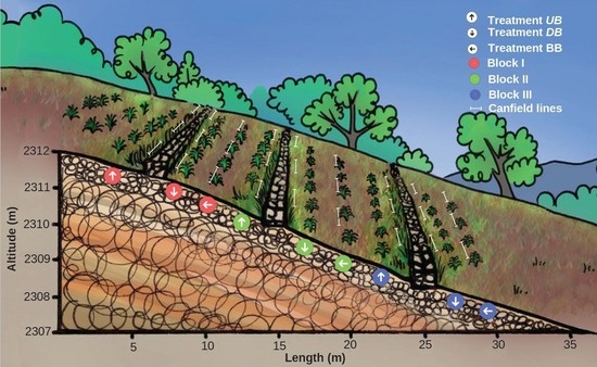
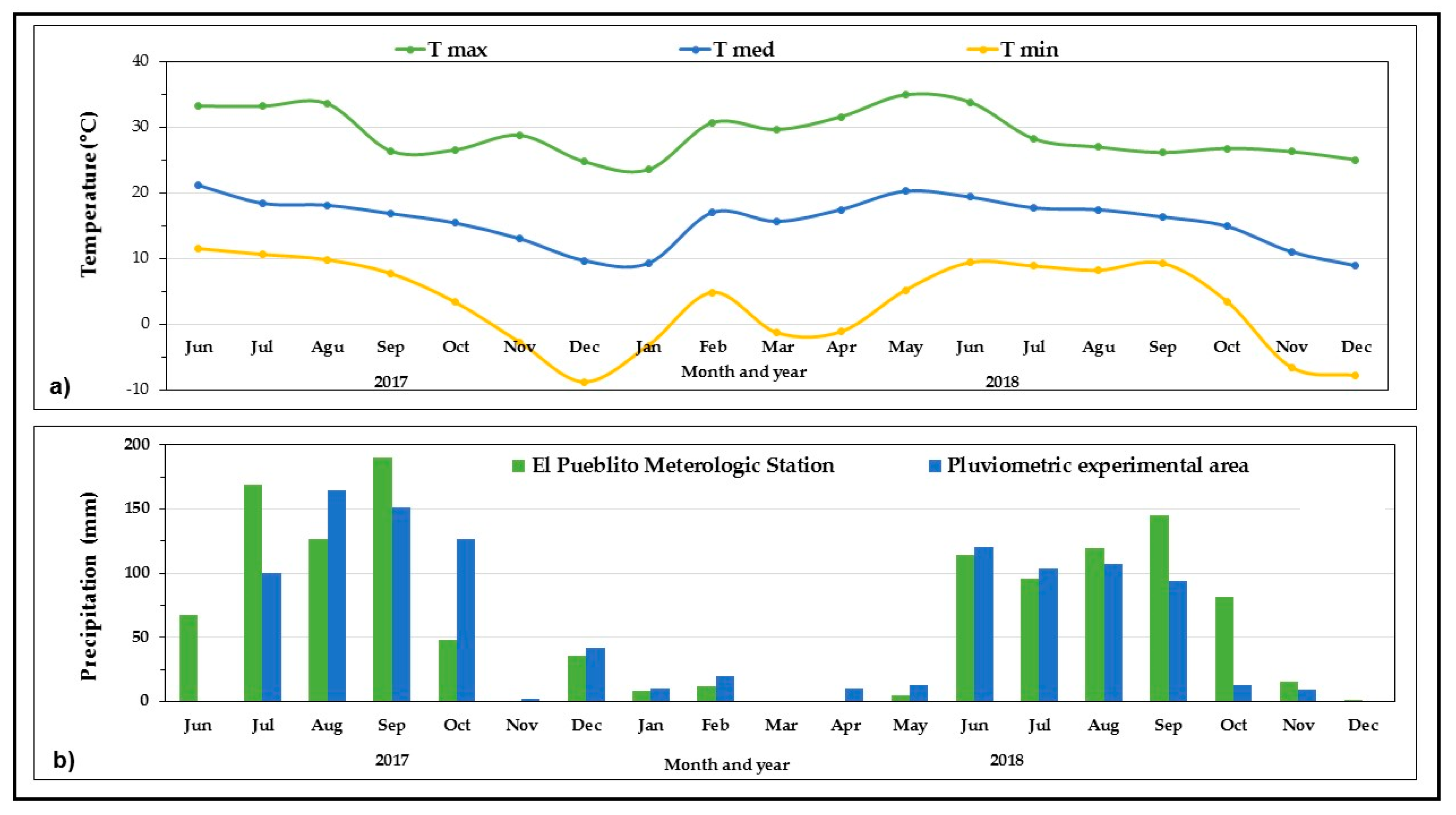
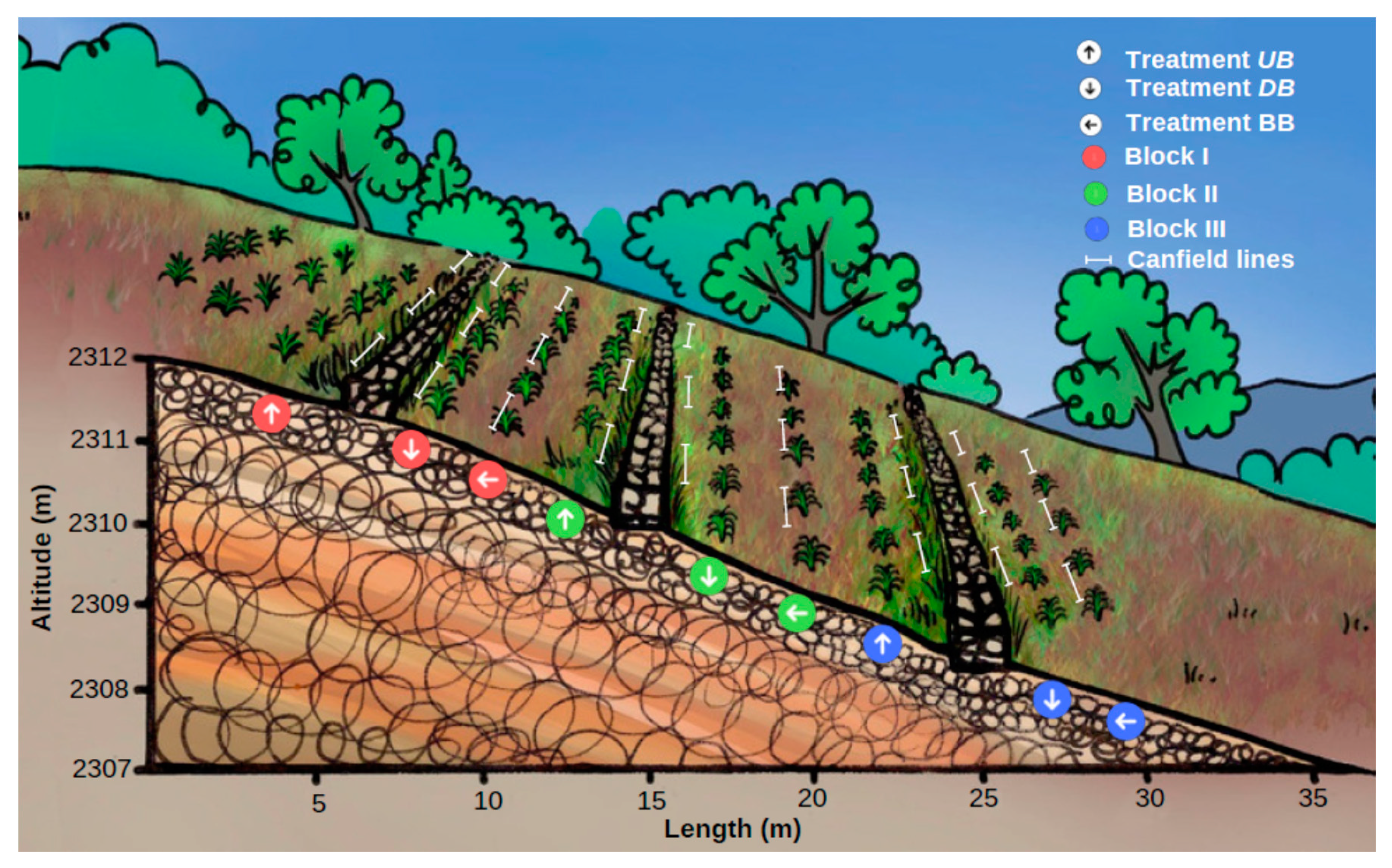
2.1. Study Area

This study was carried out at the Tres Molinos experimental site located in Ejido El Nayar, within the municipality of Durango, 20 km southwest of the City of Durango, Mexico. The site is located at the geographical coordinates of 23°50ʹ55.73″ N and 104°46ʹ13.37″ W, at an altitude of 2304 m (Figure 1).

2.2. General Characteristics of the Site

The plant community corresponds to an aciculi-sclerophyll forest located on the interior slopes of the Sierra Madre Occidental [23]. The most important communities are composed of Quercus, Juniperus and Pinus forests as well as native grasslands [24].
The experimental site has a slope of 12%; soils are classified as lithosol; soil texture is silt loamy [23]; and its use is silvopastoral—however, since the area was reforested this activity has been excluded. The experimental area presents a high degree of soil degradation due to deforestation and overgrazing (Figure 1).
The climate is temperate sub-humid. The ambient temperature was recorded from June 2017 through December 2018 in an hourly manner using a HOBO® data logger (Onset, Bourne, MA, USA), which was located at a height of 2 m with no obstructions around it. Figure 2 shows the monthly temperature in the study area, where the minimum temperature recorded was −9 °C and the maximum temperature recorded was 35 °C, with an average temperature of 15 °C.
Similar to temperature, the monthly rainfall was recorded using a hand-made rain gauge and a 20 L water container with a 27 cm diameter and a 34 cm height. The upper part of the water container was cut and assembled inversely at the base so that it was sealed, and this served as a rainwater collector. It was designed this way to avoid any evaporation. The catchment height was approximately 30 cm. The annual average precipitation for 2017 was 617 mm and for 2018 it was 503 mm. The data were corroborated with the data from the National Water Commission (CONAGUA, Spanish acronym) climatological station situated close to the study area (Figure 2).

2.3. Site Preparation

In August 2016, in an area of approximately 3000 m2, SB were built based on the surrounding quarry stone, 100 m long, 40 cm high and 40 cm wide. SB were hand-made by people from the surrounding area according to a contour level design using the hose method. The distance between each SB was approximately 10 m (Figure 1).

2.4. Physicochemical Characteristics of the Soil

At the beginning of the investigation, the physicochemical characteristics of the soil were analysed by collecting six randomly distributed soil samples. The pH was determined using a potentiometer; the electrical conductivity was determined using a conductivity meter; the organic matter was determined using the Walkley-Black method; the texture was determined using the Bouyoucos method and phosphorus and nitrates were determined using chromatography, permanent wilting point and field capacity (Table 1). The analyses were conducted in the Environmental Sciences Laboratory at the National Polytechnic Institute in the Interdisciplinary Research Centre for Regional Integral Development, Durango Unit (IPN-CIIDIR-DGO is the Spanish acronym), based on the provisions of the Official Mexican Standard NOM-021-SEMARNAT-2000 [25].

2.5. Evaluated Treatments

According to the position of the tree rows related to the SB, treatments were defined as: (1) upslope bund (UB); (2) downslope bund (DB); and (3) between bunds (BB) (Figure 1 and Figure 3 and Table 2).
The reforestation was carried out at the beginning of September 2016, with a density of 1600 plants ha−1 which were planted at a distance of 2 m from each other. Before the reforestation, stumps were planted with a 30 cm wide strip and at a 30 cm depth. A total of 17, 10-month-old plants were planted in each row. The treatments were distributed in an experimental randomized block design, with three repetitions per treatment.

2.6. Evaluation

Since the literature establishes that stone SB have an influence on vegetation and soil [4,12,21,22], three main aspects were evaluated to measure this influence: (a) survival and growth of P. engelmannii Carr.; (b) aerial cover and production of aerial herbaceous plants; and (c) physicochemical characteristics of the soil. Although these elements were analysed separately, they interact at the study site and together may reflect the effect of the treatments evaluated.
The evaluation was carried out in October 2018 after 25 months of planting and the dependent variables registered are described in the following section.

2.6.1. Survival and Growth of Reforestation

The number of individual plants (dead and alive) was recorded; each living specimen was measured for (1) height (cm) from the base of the stem to the apical bud, with the help of a measurement ruler which was graduated in millimetres and (2) basal diameter, which was recorded at the base of the stem (mm) using a Surtex® digital vernier with an approximate accuracy of hundredths of 1 mm.

2.6.2. Aerial Cover and Production of Aerial of Herbaceous Plants

Aerial Cover

The aerial (canopy) vegetation cover was measured using Canfield lines [26]; for this experimental unit, three lines of 3 m in length (27 in total) were established and placed parallel to one side of the planting lines at a distance of 30 cm (Figure 3) and between SB.
On each line intercept (Canfield), the following variables were estimated:
  • Aerial coverage of herbaceous plants;
  • Shrub cover;
  • Soil without coverage (considered as bare ground);
  • Mulch. This refers to residues that were derived from material of plant origin.

Production of Aerial of Herbaceous Plants

The production of aerial of herbaceous plants was estimated by cutting the plants at ground level in plots of 0.5 m2 and later the phytomass was dried in a forced air oven at 55 °C until a constant weight was attained. Finally, the dry weight and production were determined and extrapolated to kg ha−2. The number of ha required to support an animal unit (ha UA−1) was calculated (with an assumption that a cow with 450 kg of live weight consumes 13.5 kg day−1 yr−1, using the following equation [27]:
Rc = ⌊(RA)/(AF × DU)⌋,
where Rc represents Rangeland Coefficient, RA is annual forage requirement (4927.5 kg), AF is available forage (aerial phytomass kg ha−1), and DU represents the degree of use (recommended proportion of forage consumed 50%).

2.6.3. Physicochemical Characteristics of the Soil

During the month of October 2018, after 25 months of planting, nine soil samples were collected per experimental unit to determine any change in soil quality. The variables under consideration were the same as those at the beginning of the investigation. The analyses were carried out in the Soil Laboratory at the National Centre for Disciplinary Research in Relation to Water, Soil, Plant, Atmosphere (CENID-RASPA, is the Spanish acronym) at the National Institute of Forestry, Agriculture and Livestock Research (INIFAP, is the Spanish acronym).
The soil moisture variable was measured at the beginning of the study. However, due to inconsistencies in the equipment (hand-made gypsum sensors) in determining this parameter, it was decided not to report these data.

2.7. Statistical Analysis

The data of the variables, such as survival, aerial coverage of herbaceous, arboreal and shrub, mulch, and soil without coverage, were expressed as a percentage. These data frequently do not present a normal distribution because they are more adjusted to a binomial distribution. Hence, to approximate a normal distribution, the data were transformed using the arcsine and square root function [28]. Subsequently, the data underwent a Shapiro–Wilk normality analysis (p > 0.05). When the height and diameter did not fulfil the assumption of normality, the nonparametric statistical test of Kruskal-Wallis was used. The variance analysis was performed on the variables which were normal. A comparison of means was carried out using Duncan’s Multiple Range Test (DMRT) (p < 0.05) for finding any significance. Statistical analyses were performed using the SAS 9.0 program [29].

3. Results

3.1. Survival and Growth of Reforestation

The UB treatment obtained the highest degree of survival (80%), which was statistically different (p < 0.05) to the DB and BB treatments, which exceeded the other treatments by 27% and 30%, respectively (Table 3).
However, the height variable did not present any statistical difference between treatments (p > 0.05), with a contrast lower than 4 cm between the extreme values. In addition, the diameter, with values of 33.9 to 34.6 mm had no significant difference (p > 0.05) (Table 3).

3.2. Aerial Cover and Production of Aerial of Herbaceous Plants

3.2.1. Aerial Cover

Although the components of the evaluated herbaceous coverage did not show any significant statistical differences between treatments (p > 0.05) (Table 4), the results indicate that in the area near the stone barrier, the herbaceous coverage can produce a greater percentage of vegetation (44% and 32%) in UB and DB conditions, respectively, when compared to BB conditions (27%).
However, the results show that the soil without cover shows that 50% of the surface is devoid of vegetation—regardless of the treatment. Regarding the presence of mulch, there were no significant statistical differences (p > 0.05) between treatments (Table 4).

3.2.2. Production of Aerial Phytomass

There were no significant differences between treatments for the conditions UB (1651 kg ha−1) and DB (1058 kg ha−1), but these two results were different (p < 0.05) to BB (600 kg ha−1) (Figure 4), where UB exceeded the other treatments with 175% for BB, while DB was 76% higher. Based on the availability of forage in each of the conditions, the calculated Rangeland coefficients were 6, 9 and 16 ha UA−1 in the treatments UB, DB and BB, respectively.

3.3. Physicochemical Characteristics of the Soil

Based on the results of Table 5 and according to NOM-021-SEMARNAT-2000 [25], the soil is considered to be moderately acidic, which is characteristic of forest soils. Salinity occurs with minimal effects, while values of soil organic matter (SOM) place it in a central classification, and with respect to nutrients, these are considered minimal values.

4. Discussion

4.1. Survival and Growth of Reforestation

The UB treatment had the highest percentage of survival of P. engelmannii Carr. (80%), exceeding the other treatments by approximately 30% and 63%, respectively, as reported by CONAFOR [14] after one year of planting. Similarly, our results are greater than those reported by Prieto et al. [17] with 17.5% and 67.5%, in individuals of the same species, after 13 months of planting on a site with similar environmental conditions.
Although height was not significant, the similar growth in the different treatments can be explained by the cespitose habit that characterizes P. engelmannii Carr. in its first years of growth in place of a greater increase in diameter [30,31]. On the other hand, the recommended annual precipitation for the optimal growth is 600 to 900 mm [30]. However, the values recorded at the study site were at the lower limit and/or below the minimum (617 mm in 2017, and 503 mm in 2018), which could have limited the development of pine trees [32].

4.2. Plant Aerial Cover and Production of Aerial of Herbaceous Plants

4.2.1. Aerial Cover

Although more than 50% of soil lacks vegetation in all treatments, it is expected that over time the implementation of SB will reduce the proportions of bare soil on site. According to Klik et al. [4], the areas near the SB offer better conditions for the development of the vegetation due to the retention of solids and the accumulation of mulch (organic matter, litter, etc.) which is dragged towards the SB.

4.2.2. Production of Aerial Phytomass

The presence of SB favoured the production of aerial phytomass in treatments that were situated close to the SB, while the BB treatment was inferior—which can be due to the deterioration that the area had suffered as a result of overgrazing. According to Technical Advisory Committee for Regional Determination of Coefficients of Rangeland (COTECOCA, Spanish acronym) [24], the Rangeland coefficient for that forage productivity site is 18 ha UA−1, considering the degree of utilization to be 50% in good condition, based on the native vegetation. However, regarding the phytomass that was estimated in the present study, the coefficients for the three conditions were 6, 9 and 16 ha UA−1 (UB, DB and BB, respectively).
In their respective studies, Klik et al. [4] and Strohmeier et al. [33] explained that the implementation of SB improved the hydrological conditions of the soil by interrupting the hydrological connectivity of the slope, by which the surface runoff is reduced—which increases the time of infiltration along its structure as well as the soil moisture content of the whole land. By holding the water longer, there can be an increase in crop yield, since this factor extends the growing season after the rainy season. Those authors suggest that this technique is an effective alternative to establish an agriculture that resists climate disorders in areas with erosion problems.
On the other hand, Hermosillo et al. [34] noted that the SB favour the spreading of moisture especially near to them, whereas Ramírez et al. [35] observed that this was due to the presence of solids and organic matter that was dragged towards the SB. Another important aspect is that the presence of SB retains the seeds that are dragged by the runoff, which turns the space into a natural seed bank [6].

4.3. Physicochemical Characteristics of the Soil

According to NOM-021-SEMARNAT-2000 [25], the soil characteristics evaluated before the investigation (2016) were similar to those analysed two years later.
It is expected that SB influence vegetation growth and establishment positively by increasing soil depth and nutrients due to an increment of the soil retention [2]. Similarly, Hishe et al. [36] agreed that SB have positive effects on the physicochemical properties of soil by diminishing erosion.
Although contour SB are one of the most expensive (US $0.98 m−1) soil conservation practices, its benefits pay off [37]. According to Cotler [38], soil and nutrients loss has an average cost of US $46.1 ha−1, annually. The calculated investment return in this study site would be in 6.5 years, taking into account that SB may last up to 15 years without considering other benefits, such as carbon reserves; water storage in the soil; the increase of the grassland coefficient; and others that point to forest regeneration.

5. Conclusions

The contour stone bunds showed a positive effect on the survival of P. engelmannii Carr., as well as in the production of herbaceous phytomass. Although it is considered that the time elapsed since the implementation of the stone bunds is not enough to expect significant results in the variables that were measured, it is expected that in the medium and long term, the growth of the plant cover of P. engelmannii Carr., and the improvement in soil characteristics, could be visible. Therefore, it is recommended to evaluate these experimental plots over a longer term to monitor pine tree establishment in addition to the physicochemical characteristics of the soil.

Author Contributions

M.d.C.P.-R. writing—original draft preparation, formal analysis, investigation; J.Á.P.-R. original draft preparation, conceptualization, funding acquisition, methodology, investigation; Discussed the results and revised the manuscript. F.O.C.-C. conceptualization, formal analysis, methodology. Investigation; M.E.P.-L. funding acquisition, writing—review and editing; J.d.J.M.-R. software, writing—review and editing; O.R.-E., writing—review and editing; H.R.-G. writing—review and editing, validation.

Funding

This research was funded partially by Consejo Nacional de Ciencia y Tecnología (project name: “Efecto ambiental de la gestión del agua residual doméstica en la cuenca San Pedro Mezquital”), grant number CONACYT 214829.

Acknowledgments

The first author gives thanks to CONACYT for the financial support to carry out his studies in the Sciences; to the Programa Institucional de Doctorado en Ciencias Agropecuarias y Forestales for the financial support to strengthen the present investigation, to Gerencia Operativa del Consejo de Cuenca de los rios Presidio al San Pedro, for their management and contribution in establishing the conservation and reforestation works in the Ejido El Nayar and the Environmental Sciences Laboratory of the IPN CIIDIR-Durango, Juan Carlos Rodríguez and Ariana Arreola Ortiz for their valuable support in the analysis of samples in the laboratory, and to Ramón Silva Flores, for his important contributions in the implementation of the work in field.

Conflicts of Interest

The authors declare no conflict of interest.

References

  1. Food and Agriculture Organization of the United Nations. Los Suelos Están en Peligro, Pero la Degradación Puede Revertirse. 2015. Available online: http://www.fao.org/news/story/es/item/357165/icode/ (accessed on 25 May 2019).
  2. Monar, G.N.; González, M.; González, V.; Fierro, S.; Llerena, S.; Hidalgo, I. Evaluación de la erosión física y química del suelo en la zona nor-occidental de la provincia Bolívar-Ecuador. Rev. Ecuat. Investig. Agropecu. 2018, 2, 13–20. [Google Scholar] [CrossRef]
  3. Hanks, R.J. Applied Soil Physics: Soil Water and Temperature Applications, 2nd ed.; Springer Science & Business Media, LLC: New York, NY, USA, 1992; p. 173. [Google Scholar]
  4. Klik, A.; Schürz, C.; Strohmeier, S.; Demelash, N.M.; Ziadat, F.; Schwen, A.; Zucca, C. Impact of stone bunds on temporal and spatial variability of soil physical properties: A field study from northern Ethiopia. Land. Degrad. Dev. 2017, 29, 585–595. [Google Scholar] [CrossRef]
  5. Dingman, S.L. Physical Hydrology; Waveland Press; Macmillan Publishing Company: New York, NY, USA, 1994; p. 575. [Google Scholar]
  6. Gutiérrez, R.E.; Sierra, T.J.S.; Ramírez, G.H. Obras Para la Captación de Humedad en Tierras de Pastoreo; Folleto Técnico para para Productores Núm. 17; Campo Experimental La Campana; CIRNOC. INIFAP: Aldama, Mexico, 2014; ISBN 978-607-37-0305-5. [Google Scholar]
  7. Senra, A. Impacto del manejo del ecosistema del pastizal en la fertilidad natural y sostenibilidad del suelo. Av. Investig. Agropecu. 2009, 13, 3–16. Available online: http://www.redalyc.org/articulo.oa?id=83712256001 (accessed on 21 May 2019).
  8. Granados-Sánchez, D.; Hernández-García, M.A.; Vázquez-Alarcón, A.; Ruíz-Puga, P. Los procesos de desertificación y las regiones áridas. Rev. Chapingo Ser. Cienc. For. Ambiente 2009, 19, 45–66. Available online: https://www.redalyc.org/pdf/629/62926254004.pdf (accessed on 21 May 2019). [CrossRef]
  9. Secretaría de Medio Ambiente y Recursos Naturales. Suelos. 2016. Available online: https://apps1.semarnat.gob.mx:445/dgeia/informe15/tema/pdf/Cap3_Suelos.pdf (accessed on 25 May 2019).
  10. Bolaños, G.M.A.; Paz, P.F.; Cruz, G.C.O.; Argumedo, E.J.A.; Romero, B.V.M.; De la Cruz, C.J.C. Mapa de erosión de los suelos de México y posibles implicaciones en el almacenamiento de carbono orgánico del suelo. Terra Latinoam. 2016, 34, 271–288. Available online: https://www.redalyc.org/pdf/573/57346617003.pdf (accessed on 21 May 2019).
  11. Comisión Nacional Forestal. La Degradación de Suelos Afecta la Producción de Alimento. 2013. Available online: http://www.conafor.gob.mx:8080/documentos/docs/7/4659La%20degradaci%C3%B3n%20de%20suelos%20afecta%20producci%C3%B3n%20de%20alimento.pdf (accessed on 21 May 2019).
  12. Comisión Nacional Forestal. Protección, Restauración y Conservación de Suelos Forestales. 2007. Available online: http://www.conafor.gob.mx:8080/documentos/docs/20/1310Manual%20de%20Conservacion%20de%20Suelos%20.pdf (accessed on 21 May 2019).
  13. Valles, G.A.G.; Ríos, S.J.C.; López, H.J.A.; Ibarra, F.J.M.; Espinosa, A.J.J.; Mar, T.C.L. Caracterización del sector forestal en el estado de Durango. In Situación Agropecuaria y Forestal en Estado de Durango; Libro Técnico No. 4; Campo Experimental Valle del Guadiana INIFAP: Durango, Mexico, 2011; pp. 139–174. [Google Scholar]
  14. Comisión Nacional Forestal. Alcanza 63% Sobrevivencia de Árboles Plantados Este Sexenio. 2017. Available online: https://www.gob.mx/conafor/prensa/aumenta-63-la-sobrevivencia-de-arboles-plantados-este-sexenio (accessed on 21 May 2019).
  15. Cuevas, F.L.; Sartorius, D.T.; Carreón, J.S.G.; Herrera, J.A.G.; Olarte, J.C.G.; Méndez, H.H.; Vázquez, R.C. Protección, Restauración y Conservación de Suelos Forestales. Manual de Obras y Prácticas, 3rd ed.; Comisión Nacional Forestal (CONAFOR); SEMARNAT: Mexico City, Mexico, 2007; p. 207. [Google Scholar]
  16. Vilagrosa, A.; Caturla, R.N.; Hernández, N.; Cortina, J.; Bellot, J.; Vallejo, V.R. Reforestación en ambiente semiárido del sureste peninsular. Resultados de las investigaciones desarrolladas para optimizar la supervivencia y el crecimiento de especies autóctonas. In Montes Para la Sociedad del Nuevo Milenio; III Congreso Forestal Español; Junta de Andalucia-Consejeria de Medio Ambiente: Andalucía, Spain, 2002; Volume 4, p. 5. [Google Scholar]
  17. Prieto, R.J.A.; Duarte, S.A.; Goche, T.J.R.; González, O.M.M.; Pulgarín, G.M.A. Supervivencia y crecimiento de dos especies forestales, con base en la morfología inicial al plantarse. Rev. Mex. Cienc. For. 2018, 9, 151–168. [Google Scholar] [CrossRef]
  18. Jafer, M.A. Analysis gender role and factors affecting soil and water conservation adoption in Kersa Districts of Eastern Hararghe Zone, Ethiopia: The case of Fanya juu, soil and stone bund measure. Int. J. Agric. Sci. Res. Technol. Ext. Educ. Syst. 2018, 8, 49–58. Available online: http://ijasrt.iau-shoushtar.ac.ir/art (accessed on 21 May 2019).
  19. Radulovich, R.A. Tecnologías Productivas Para Sistemas Agrosilvopecuarios: De Ladera Con Sequia Estacional; IICA/CATIE: Turrialba, Costa Rica, 1994; p. 190. [Google Scholar]
  20. Alanís-Rodríguez, E.; Valdecantos-Dema, A.; Jiménez-Pérez, J.; Rubio-Camacho, E.A.; Yerena-Yamallel, J.I.; González-Tagle, M.A. Post-fire ecological restoration of a mixed Pinus-Quercus forest in northeastern Mexico. Rev. Chapingo Ser. Cienc. For. Ambiente 2015, 21, 157–170. Available online: https://www.redalyc.org/pdf/629/62941169002.pdf (accessed on 15 August 2019). [CrossRef]
  21. Gebrernichael, D.; Nyssen, J.; Poesen, J.; Deckers, J.; Haile, M.; Govers, G.; Moeyersons, J. Effectiveness of SBstone bunds in controlling soil erosion on cropland in the Tigray Highlands, northern Ethiopia. Soil Use Manag. 2005, 21, 287–297. [Google Scholar] [CrossRef]
  22. Wolka, K.; Moges, A.; Yimer, F. Effects of level soil bunds and SBstone bunds on soil properties and its implications for crop production: The case of Bokole watershed, Dawuro zone, Southern Ethiopia. Agric. Sci. 2011, 2, 357–363. [Google Scholar] [CrossRef]
  23. Instituto Nacional de Estadística y Geografía. Prontuario de Información Geográfica Municipal de los ESTADOS UNIDOS Mexicanos. 2010. Available online: http://www3.inegi.org.mx/contenidos/app/mexicocifras/datos_geograficos/10/10005.pdf (accessed on 21 May 2019).
  24. Diario Oficial de la Federación. Comisión Técnico Consultiva Para la Determinación Regional de Los Coeficientes de Agostadero-Secretaria de Agricultura y Recursos Hidráulicos; Calypso: Durango, Mexico, 1979. [Google Scholar]
  25. Secretaría de Medio Ambiente y Recursos Naturales. Norma Oficial Mexicana NOM-021-SEMARNAT-2000. Que Establece Las Especificaciones de Fertilidad, Salinidad y Clasificación de Suelos. Estudios, muestreo y Análisis. Diario Oficial de la Federación. 2002. Available online: http://www.ordenjuridico.gob.mx/Documentos/Federal/wo69255.pdf (accessed on 28 May 2019).
  26. Contreras-Hinojosa, J.R.; Volke-Haller, V.; Oropeza-Mota, J.L.; Rodríguez-Franco, C.; Martínez-Saldaña, T.; Martínez-Garza, A. Estado actual y causas de la degradación de los agostaderos en el municipio de Yanhuitlán, Oaxaca. Terra Latin. 2003, 21, 427–435. Available online: https://www.redalyc.org/pdf/573/57311097001.pdf (accessed on 20 May 2019).
  27. Cantú, B.J.E. Manejo y Mejoramiento de Pastizales, 1st ed.; Doble Hélice: Chihuahua, Mexico, 2011. [Google Scholar]
  28. Zar, J.H. Biostatistical Analysis, 5th ed.; Pearson Prentice Hall: Upper Saddle River, NJ, USA, 2010. [Google Scholar]
  29. Statistical Analysis System. SAS/STAT® 9.2 User’s Guide, 2nd ed.; SAS Institute Inc.: Cary, NC, USA, 2009. [Google Scholar]
  30. Ávila-Flores, I.J.; Hernández-Díaz, J.C.; González-Elizondo, M.S.; Prieto-Ruíz, J.A.; Wehenkel, C. Pinus engelmannii Carr. in northwestern México: A review. Pak. J. Bot. 2016, 48, 2159–2166. [Google Scholar]
  31. García, R.J.L.; Prieto, R.J.A.; Aguilar, V.J.L.; Huchín, A.S.; Mejía, B.J.M. Producción de planta del genero Pinus en vivero en clima templado frio. In Publicación Especial Número 28, 1st ed.; Campo Experimental Valle del Guadiana INIFAP: Durango, Mexico, 2009; 20p, Available online: http://biblioteca.inifap.gob.mx:8080/xmlui/bitstream/handle/123456789/2091/Produccion%20de%20planta%20del%20genero%20pinus%20en%20vivero%20en%20clima%20templado%20frio.pdf?sequence=1 (accessed on 21 May 2019).
  32. Ávila-Flores, I.J.; Prieto-Ruíz, J.A.; Hernández-Díaz, J.C.; Whehenkel, C.A.; Corral-Rivas, J.J. Preacondicionamiento de Pinus engelmannii Carr. mediante déficit de riego en vivero. Rev. Chapingo Ser. Cienc. For. Ambiente 2014, 20, 237–245. [Google Scholar] [CrossRef]
  33. Strohmeier, S.; Rieder, J.; Kaltenleithner, M.; Demelash, N.; Guzmán, G.; Ziadat, F.; Klik, A. Using magnetite tracer to evaluate a novel plot experimental design for the assessment of soil and water conservation impacts of stone bunds in Ethiopia. EGU General Assembly Conference Abstracts. 2015, Volume 17. Available online: https://www.researchgate.net/publication/272816183_Using_cemagnetite_tracer_to_evaluate_a_novel_plot_experimental_design_for_the_assessment_of_soil_and_water_conservation_impacts_of_stone_bunds_in_Ethiopia (accessed on 17 June 2019).
  34. Hermosillo, R.D.E.; Ramírez, G.H.; Rivero, O.J.M.; Ramírez, M.J.M. Retención de Suelo en Obras de Conservación; Desplegable para productores No. 40; Campo Experimental La Campana; CIRNOC. INIFAP: Aldama, Mexico, 2016. [Google Scholar]
  35. Ramírez, G.H.; Hermosillo, R.D.E.; Sierra, T.J.S.; Ponce, R.M.C. Infiltración de Agua en un Bosque de Pino-Encino; Desplegable para productores No. 54; Campo Experimental La Campana; CIRNOC. INIFAP: Aldama, Mexico, 2016. [Google Scholar]
  36. Hishe, S.; Lyimo, J.; Bewket, W. Soil and water conservation effects on soil properties in the Middle Silluh Valley, northern Ethiopia. Int. Soil Water Conserv. Res. 2017, 5, 231–240. [Google Scholar] [CrossRef]
  37. Comisión Nacional Forestal. Costos Unitarios Promedio Nacionales de Las Obras de Restauración de Suelos y Reforestación, Para Proyectos de Compensación Ambiental Por Cambio de Uso de Suelo en Terrenos Forestales. 2017. Available online: http://procurement-notices.undp.org/view_file.cfm?doc_id=125651 (accessed on 11 August 2019).
  38. Cotler, H.; López, C.; Martínez-Trinidad, S. Cuánto nos cuesta la erosión de suelos? Aproximación a una valoración económica de la pérdida de suelos agrícolas en México. Investig. Ambient. 2011, 3, 31–43. Available online: http://www.revista.inecc.gob.mx/article/view/134#.XNMOr-VKjIU (accessed on 13 August 2019).
Figure 1. (a) Study area; (b) polygon of the experimental area in the Tres Molinos area; (c) image taken by the drone showing the level stone bunds; (d) reforestation with P. engelmannii Carr. above and below the SB.
Sustainability 11 05033 g001
Figure 2. Monthly climatic data of the experimental area during the years 2017 and 2018. (a) Maximum, average and minimum temperatures; (b) precipitation.
Sustainability 11 05033 g002
Figure 3. Cross-section view of stone bunds and planting of P. engelmannii Carr. The treatments evaluated and the location of the Canfield Lines are represented by symbols.
Sustainability 11 05033 g003
Figure 4. Herbaceous aerial phytomass determined. a b Different letters on the bars indicate significant differences among treatments (p < 0.05). The standard error of the mean is represented on the bars.
Sustainability 11 05033 g004
Table 1. Physicochemical characteristics of the soil in the experimental area.
VariableValue
pH6.0 ± 0.08
Electrical conductivity (dS m−1)0.1 ± 0.03
Calcium carbonates (%)<0.1 ± 0.001
Organic material (%)2 ± 0.17
Nitrates (mg kg−1)7 ± 1.2
Phosphorus (ppm)Non-detectable
± Standard Error.
Table 2. The treatments established to evaluate the effect of the stone bunds on vegetation and soil.
TreatmentLocationLegend
180 cm upslope bund of the barrierUB
280 cm downslope bund of the barrierDB
3Between bunds 4.5 mBB
Table 3. Survival, height and diameter of P. engelmannii Carr. 24 months after planting.
TreatmentSurvival (%)Height (cm)Diameter (mm)
UB80.3 ± 6.4 a26.2 ± 1.8 a33.9 ± 1.4 a
DB53.3 ± 11.1 b28.7 ± 2.7 a34.6 ± 1.3 a
BB49.6 ± 8.6 b24.8 ± 1.9 a33.9 ± 1.5 a
a b Different letters for the same variable indicate significant differences between treatments, according to the Duncan multiple range test (p < 0.05) ± standard error.
Table 4. Plant cover with respect to its location on the stone bunds SB.
ComponentTreatment
UBDBBB
Aerial coverageGrasses (%)26.5 ± 6 a34.2 ± 7 a21.7 ± 5 a
Composite (%)2.1 ± 1 a1.1 ± 1 a1.2 ± 1 a
Shrubs (%)3.8 ± 2 a8.4 ± 6 a3.7 ± 2 a
Total32.4 ± 6 a43.7 ± 7 a26.6 ± 5 a
Mulch (%) 11.2 ± 4 a6.2 ± 2 a6.9 ± 1 a
Soil without coverage (%) 56.4 ± 6 a50.1 ± 7 a66.5 ± 5 a
a Same letters for the same variable indicate no significant differences between treatments, according to the Duncan multiple range test (p < 0.05) ± standard error.
Table 5. Physicochemical characteristics of the soil of the experimental area by treatments.
VariableTreatment
UBDBBB
Sand (%)323533
Clay (%)332733
Silt (%)343834
Textural classClay loamLoamClay loam
pH6.1 ± 0.32 a6.3 ± 0.07 a6.4 ± 0.24 a
Electrical conductivity (dS m−1)0.3 ± 0.02 a0.3 ± 0.04 a0.2 ± 0.03 a
Calcium carbonates (%)0.6 ± 0.08 a0.6 ± 0.17 a0.5 ± 0.08 a
Organic material (%)1.9 ± 0.69 a1.5 ± 0.26 a1.8 ± 0.50 a
Nitrates (mg kg−1)3.0 ± 1.10 a2 ± 1.4 a2 ± 0.9 a
Phosphorus (ppm)Non-detectableNon-detectableNon-detectable
Available potassium (mg kg−1)867 ± 295 a717 ± 142 a767 ± 136 a
a Same letters for the same variable indicate no significant differences between treatments, according to the Duncan multiple range test (p < 0.05) ± standard error.

