Article

Mechanisms of Forest Restoration in Landslide Treatment Areas

1
Department of Water Resources Engineering and Conservation, Feng Chia University, Taichung 407, Taiwan
2
Department of Horticulture, National Chung Hsing University, Taichung 402, Taiwan
3
Department of Soil and Water Conservation, National Chung Hsing University, Taichung 402, Taiwan
*
Author to whom correspondence should be addressed.
Sustainability 2014, 6(10), 6766-6780; https://doi.org/10.3390/su6106766
Submission received: 21 April 2014 / Revised: 12 September 2014 / Accepted: 15 September 2014 / Published: 29 September 2014
(This article belongs to the Special Issue Sustainable Land Use and Ecosystem Management)

Abstract

:
Reforestation after a landslide facilitates competition between herbaceous plants and arborous plants. Tangible variations in grassland areas in regions susceptible to landslides can only be found within collections of trees. A landslide area in the Sule Watershed was investigated. Relative illuminance results reveal that the Rhodes grass (Chloris gayana Kunth) biomass in this landslide area increases with relative illuminance. A comparison of regions with tree islands indicates that the size of the grassland areas decreased and the number of tree islands increased during 2005–2010. Furthermore, a germination experiment in a soil-seed bank indicates that more woody plant species exist around the tree island than in other areas in the landslide region. Trees in a tree island change the micro-climate of the landslide region, and they gather as many nutrients and as much moisture as possible, enabling vegetation to expand around the tree island. Additionally, the area with Rhodes grass and its biomass declined annually in the tree island region. Investigation results show that tree islands and soil-seed banks are suited to reforestation in landslide regions. The pioneering research will assist regional landslide management in Taiwan.

1. Introduction

Taiwan, an island formed by collisions between the Eurasian Plate and Philippines’ Sea Plate, has a fragile geology that is easily damaged by typhoons and seasonal storms, which cause landslides and forest failures. Landslide engineering has become essential to prevent continuous landslides where vegetation is absent. Vegetation engineering, often achieved by rapid large-scale coverage, slope stabilization, environmental restoration and ecological recovery, is commonly deployed in Taiwan. The goals of landslide vegetation within landslide engineering are rapidly becoming similar to those of “forestation”. Forestation to protect against landslides in Taiwan relies on the planning of annual or perennial herbaceous plants, such as shrubs and eventually trees, to form compound storied forested regions (Lin [1]).
With the formation of tree islands, seeds in the soil layers and neighboring environmental conditions dominate the vegetation succession processes in landslide regions. Generally, landslides increase land instability, and the land is likely to slide again if natural reforestation is slow. Trees islands on otherwise bare land improve the micro-climate, increase soil moisture and attract birds to stay and sow seeds via their feces; additionally, root systems fix slope soil, and trees islands reduce wind speed, accelerating forestation succession (Charles [2], Resler [3]). Artificial treatments and the introduction of vegetation accelerate forestation succession by stabilizing slopes that would otherwise be vulnerable to landslides via plant growth (Lin [1]).
In 2004, Typhoon Aere caused a landslide in the Sule Creek watershed in northern Taiwan. Subsequent water and soil conservation engineering preserved three woody plants. Reforestation of the landslide area took over ten years. This study elucidates the mechanisms of forestation succession in this landslide region following water and soil conservation engineering. The landslide in this watershed is the target of this long-term investigation. First, the relative illuminance (RI) of sunlight and the biomass of heliophytic herbaceous plants are examined to elucidate the effects of Sun illuminance on the generation of plant biomass. Second, germination of plant seeds from a soil-seed bank (i.e., seeds in soil covered with leaves) (Simpson et al. [4]) in landslide soil is experimentally examined to determine the dispersal of plants in the landslide area and the plants that will thrive in the study area. Third, aerial image data are used to identify tree islands and the expansion of preserved plants. Finally, the vegetation succession mechanism in the landslide area is discussed with reference to data, and the analytical results obtained are applied to landslide vegetation engineering.

2. Material and Methods
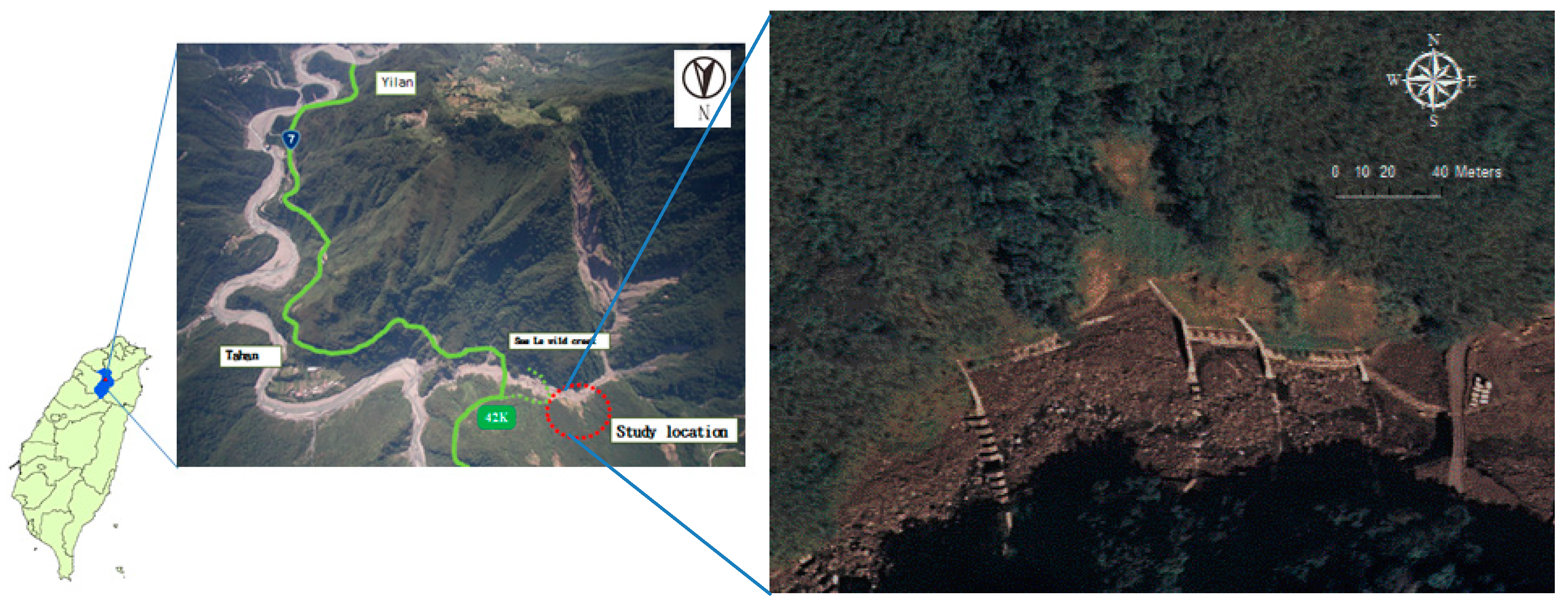
2.1. Sites

The research site is Gao-Yi District, Fushing Township, Tuoyuan County, Taiwan Datum (TWD) 97 (285,305, 2,732,957) (Figure 1). The research area is located on the landslide slope on the left bank of Sule Creek in the Shihmen Reservoir (Taiwan 7th line, Station 42 K). Sule Creek runs from west to east, with a slope of approximately 60° and an area of about 1.15 hectares at an altitude of 653 m. The mean annual temperature is roughly 20 °C; average annual humidity is around 84%, and average annual precipitation is 2350 mm (Chen et al. [5]). The geology and soil conditions on the landslide slope are challenging for plants. Additionally, the exposed surface soil, considerable erosion and slope steepness disfavor plant growth and vegetation renewal after a landslide. The rainy and typhoon season in Taiwan is May–September, during which a large amount of rainfall erodes surface soil and inhibits the sprouting of planted seeds. The dry season is November–March, during which plants likely die from drought.
Figure 1. Location of the study area.
Sustainability 06 06766 g001
Remotely piloted vehicle Airscape image (left) from the Soil and Water Conservation Bureau; orthophoto (right) with a scale of 1/5000 taken by the Aerial Survey Office, Forestry Bureau.
The landslide in the study area was a result of Typhoon Aere. Soil and water conservation treatment in the landslide area was conducted in January 2005, and involved mixed hydroseeding of grass and woody plants following grading, free grid column planting and installation of drainage facilities. Three species of woody plants, Celtis formosana Hayata, Ficus superba and Broussonetia papyrifera (paper mulberry), were retained during construction, which was completed in June 2006.

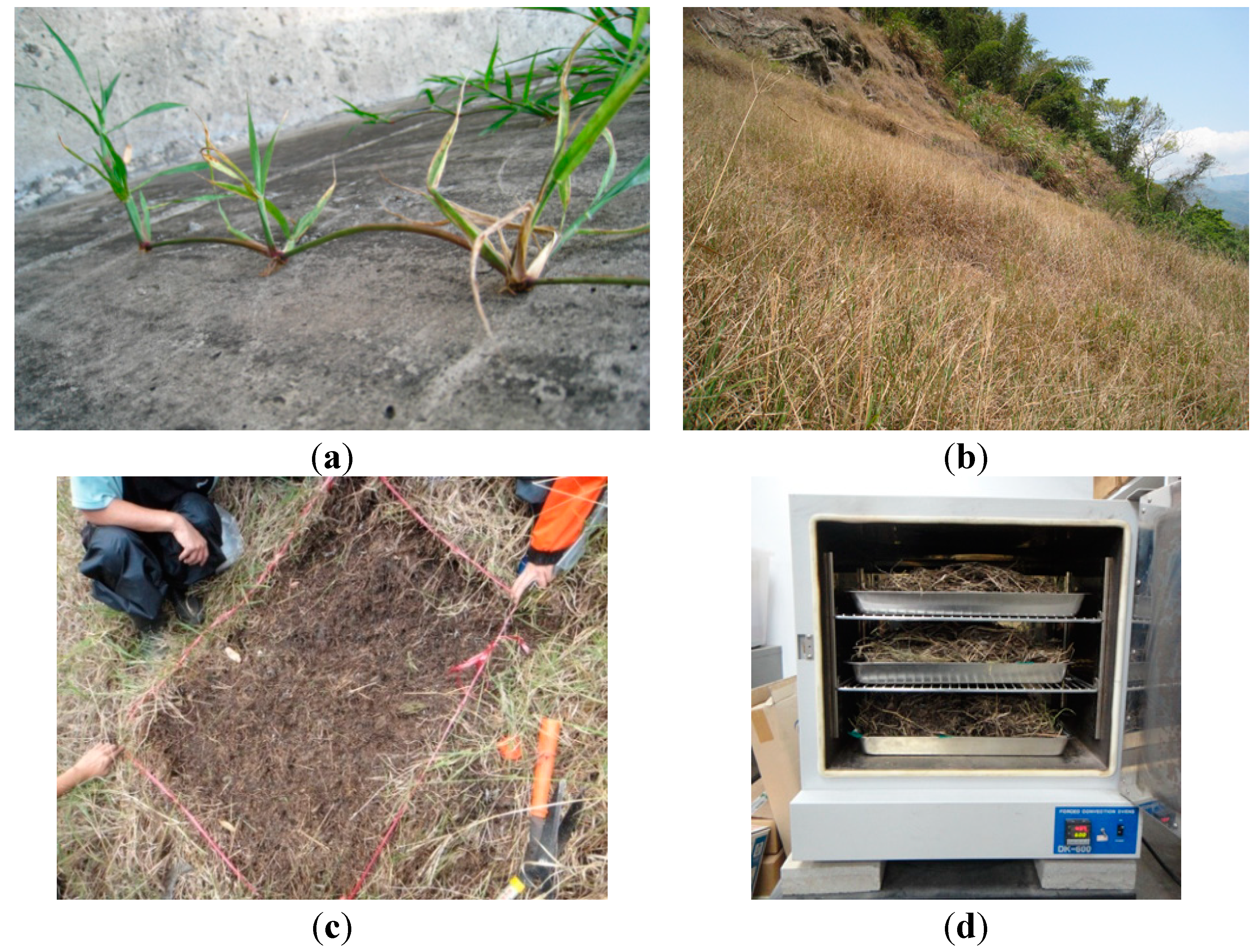
2.2. Relative Illuminance and Biomass of Rhodes Grass

Devices for measuring illuminance (TES-1339R) were placed at ten sites (Sites 1–10) (Figure 2), and relative illuminance (RI) was calculated as:
RI (%) = I1/I2 × 100%
where I1 is illuminance at the selected site and I2 is illuminance at an unsheltered point close to the test point.
Rhodes grass, a creeping perennial, spread via stolons (Figure 3a) and grew rapidly, forming a community following hydroseeding treatment of the landslide region (Figure 3b). To investigate the effect of the straw biomass in the landslide area, Rhodes grass samples were harvested. The area unit was 1 m × 1 m, and sites were selected in the straw zone inside tree island and the mixed straw-forest regions (Figure 3c). Ten samples were taken from each of three zones. After drying in shade for 24 h, samples were placed in an oven at 70 °C for another 24 h. Variations in weights were then assessed (Figure 3d). The relationship between RI and the Rhodes grass biomass was acquired using regression analysis and fitted models. The strength of the relationship was determined using the coefficient of determination (R2).
Figure 2. Sites selected for measuring relative illuminance and the germination of the soil-seed bank.
Sustainability 06 06766 g002
Notes: Sites A–E are the soil sampling sites; 1–10 are the locations where illuminance was measured.
Figure 3. Testing of the biomass of Rhodes grass. (a) Rhodes grass has rooting stolons; (b) Rhodes grass forms a community in the landslide region; (c) the biomass of Rhodes grass per unit area was determined (1 m × 1 m); (d) samples of Rhodes grass were placed in an oven.
Sustainability 06 06766 g003

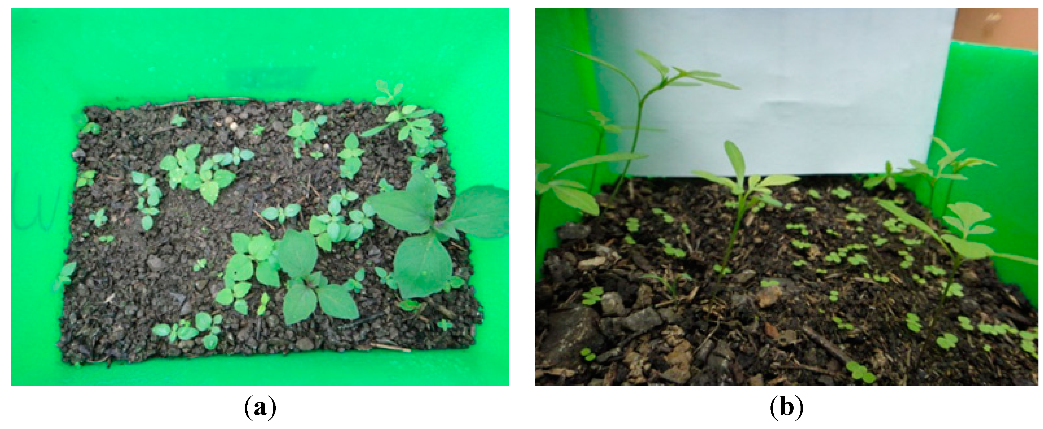
2.3. Germination of Soil-Seed Bank

This study determines the germination rate of the soil-seed bank. The selected sites are those used by Lai [6], and five soil samples are also obtained from four sites, Sites B–E, in the tree island (Figure 2) and one site in the grassland, Site A (Figure 2). Seeds were harvested at soil depths of 0–5 and 5–10 cm for use in germination tests. These seeds were placed in plant growth chambers, with a relative humidity of 60%–75% and adequate water. Test results were obtained from 6 a.m. to 6 p.m. (daytime) and from 6 p.m. to 6 a.m. (nighttime) for two months.

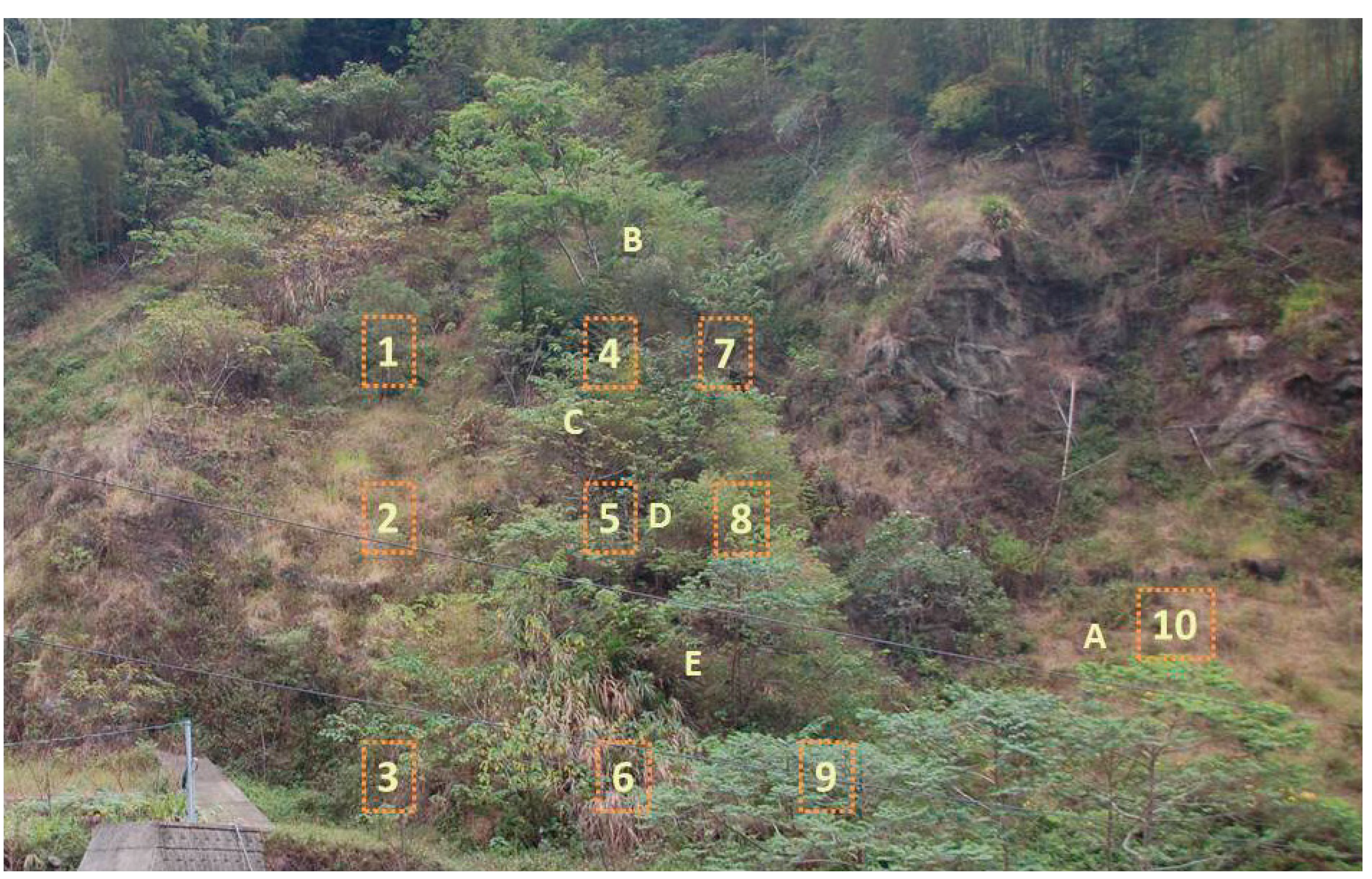
2.4. Analyses of Aerial Images and Summed Dominance Ratio

Orthophotos (scale, 1/5000), taken by Ronghaw No. 2 of the Aerial Survey Office, Forestry Bureau, in 2005, 2006, 2007, 2008 and 2010, were used to identify vegetation variations in the landslide area. Orthophotos were scanned, with geometric correction and geocoding in Arc GIS 10. The orthophotos were digitized, and the resulting images were interpreted manually to yield quantitative results for variations in the landslide area and to elucidate the directions and other trends of expansion of the tree island.
In this study, the relative coverage (by RI) and relative frequency (RF) of plant species in plots inside the landslide area are calculated and transformed into a summed dominance ratio (SDR). The local dominance of species can be determined easily using the SDR.
SDR (%) = (RI + RF)/2
RI (%) = (coverage of certain species/coverage of all species in plots) × 100
RF (%) = (number of plots where appear certain species/number of plots where appear all species) × 100

3. Results

3.1. Relative Illuminance and Biomass of Rhodes Grass

A very clear boundary exists between grassland and the tree island in the landslide area. The biomass of herbaceous plants was larger outside the tree island than inside. Shade cast by the tree island promoted the successive invasion of woody plants. Inside the tree island, the RI was 24% at Site 5 (Figure 2), and the biomass was only 56.4 g/m2; in the nearby grassland, the RI was 100% at Site 10 (Figure 2), and the biomass was 801.6 g/m2. Notably, as RI increases, the straw biomass increases. The equation is as follows: biomass (g/m2) = 6.3718 × RI + 69.423, R2 = 0.6396 (Figure 4). Therefore, the formation of a tree island can restrain the growth of alien species via shade. Another factor influencing biomass size is land slope: as slope steepness increases, the size of the straw biomass decreases.
Figure 4. Relationship between relative illuminance (RI) and the biomass of Rhodes grass at selected sites.
Sustainability 06 06766 g004

3.2. Soil-Seed Bank

Lai [6] demonstrated that seed-rain intensity, the extent of stem root suckering and the soil-seed bank influence plant invasion in a landslide area. In the seed-test in this study, 223 seeds were identified. Eight species of herbaceous plants and 74 (33.2%) Rhodes grass seeds germinated in 2009. These numbers were the highest in the six-month germinating test period. This investigation includes experiments on germinating seeds from the site utilized by Lai [6]. In 2013, after treatment for seven years, the seeds were placed in plant growth chambers. Boehmeria nivea was found in Zone A, where the cross region of herbaceous plants and tree islands exists (Table 1). Zone A had the most germinating plants at soil depths 0–5 and 5–10 cm (91 plants at each depth), indicating that Boehmeria nivea is more dominant in Zone A than in the other zones.
In Zone E in the tree island, 72 Boehmeria nivea germinated plants existed at a soil depth of 5–10 cm. Zones B, C and D had 18–36 such plants. The germination of Pouzolzia elegans was concentrated in Zones B and D at a soil depth of 0–10 cm and Zone C with a soil depth of 0–5 cm. Bidens pilosa germinates in soil at various depths and is the most effective herbaceous plant for preventing landslides, while only three Chloris gayana (Rhodes grass) plants germinated. Zone B at a soil depth of 0–5 cm and Zones C and D at a soil of depth 0–5 cm contained eight species, indicating increased species diversity in the tree island. In two months, 639 seedlings of 16 species (Table 1) grew in the soil-seed bank in the landslide area; 420 seedlings (65.73%) were Boehmeria nivea, and 152 (23.79%) were Pouzolzia elegans; these two species accounted for more than 89% of all plants.
Table 1. Number of germinating seeds in the soil-seed bank.
Names of PlantsSoil Depth: 0–5 cmSoil Depth: 5–10 cmGerminate Quantity
ABCDEABCDE
Boehmeria nivea91242018 9135363372420 *
Pouzolzia elegans 432826 201322152 *
Bidens pilosa1421613322135
Crassocephalum crepidioides 1 2121 2 9
Conyza canadensis 1 32 6
Solanum nigrum 22 4
Cynodon dactylon 1 11 3
Chloris gayana1 2 3
Solanum americanum 2 2
Celtis sinensis 1 1 *
Trema orientalis 1 1 *
Boehmeria densiflora 1 1 *
Polygonum multiflorum 1 1
Oplismenus hirtellus 1 1
Commelina communis 1 1
Poaceae 1 1
Germinating Quantity of each zone10674505229861467575639
species of each zone3844246883
Note: * Woody plants.
Compared to the experimental results obtained by Lai [6], experimental results reveal that while 223 plants of eight herbaceous species germinated in 2009, 639 plants of 16 woody and herbaceous species germinated in 2013. Both the number of species and the number of germinated seeds increased. Five species of woody plants absent in 2009 were present in 2013. In total, 74 Rhodes grass plants germinated in 2009, but only three in 2013. Neither Boehmeria nivea nor Pouzolzia elegans were found in 2009; however, 420 and 152 of these plants, respectively, germinated in 2013, indicating that the plants in the tree island gradually infiltrated the surrounding grassland. Bidens pilosa and Crassocephalum crepidioides were the first to germinate; Boehmeria nivea and Pouzolzia elegans rapidly occupied the test container after Bidens pilosa and Crassocephalum crepidioides were removed. The species of germinating seeds was not that of the seeds used in hydroseeding, such that the seedlings were likely seeds from the surrounding forest.
Bush and arbor species in this germination test were Boehmeria nivea, Pouzolzia elegans, Celtis sinensis, Trema orientalis and Boehmeria densiflora. Boehmeria nivea and Pouzolzia elegans occupied the entire test container (Figure 5a). Celtis sinensis and Trema orientalis were close to the survival tree after the landslide within Section B (Figure 2). In the germination test, most seedlings were arborous, and the most common herbaceous plant was Bidens pilosa (Figure 5b and Table 1). Because herbaceous plants were removed at the start of germination, plant growth chambers provided favorable conditions for the germination of woody plants.
Figure 5. Germination in the soil-seed bank. (a) Bush and arbor species germinated in this germination test; (b) Bidens pilosa was the most common herbaceous plant.
Sustainability 06 06766 g005

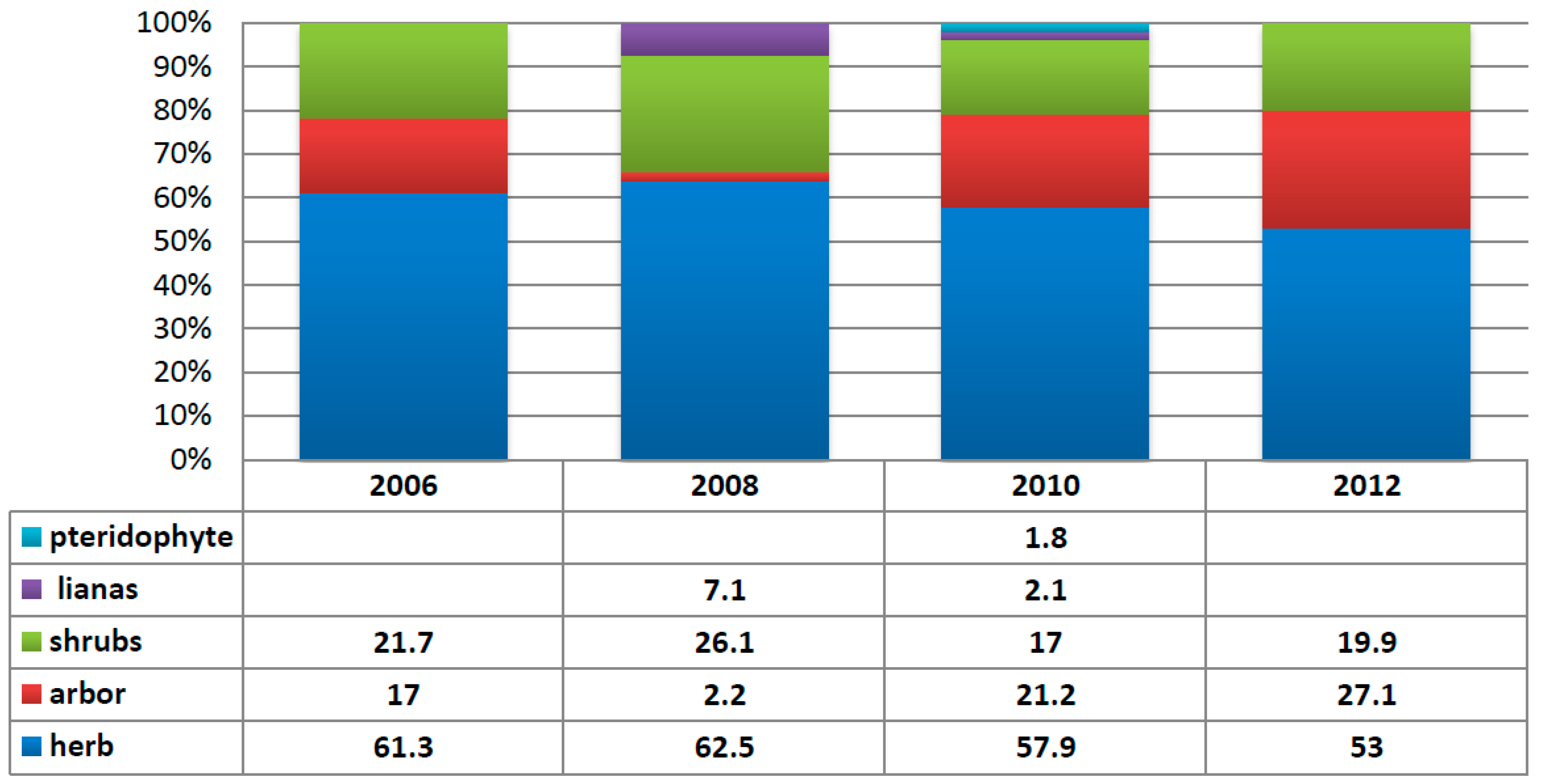
3.3. Annual Variation in the Region Containing the Tree Island and Summed Dominance Ratio

The following orthophotos (Table 2) show changes in the landslide regions and tree island for years 2006, 2007, 2008 and 2010. As mentioned, orthophotos were taken by the Aerial Survey Office, Forestry Bureau. The most recent orthophoto of the landslide was taken in 2010. The circular area in the digitized cadastral map for November, 2006, is a small tree island resulting from the retention planted five months following the soil and water conservation treatments. The tree island expanded downhill, and woody plants intruded into the landslide region in neighboring forests (Table 2). However, by October, 2010, the area happened shrunk, likely because the dominant Rhodes grass adversely affected the survival of woody plants, causing retrogression of local plant succession (Lin et al. [7]).
Table 2. Digitized orthophotos of the invasion by woody plants in the landslide area.
Year, MonthOrthophotosInvasion of RegionSite Photos
2005, January Sustainability 06 06766 i001 Sustainability 06 06766 i002 Sustainability 06 06766 i003
2006, June Sustainability 06 06766 i004 Sustainability 06 06766 i005 Sustainability 06 06766 i006
2007, January Sustainability 06 06766 i007 Sustainability 06 06766 i008 Sustainability 06 06766 i009
2008, July Sustainability 06 06766 i010 Sustainability 06 06766 i011 Sustainability 06 06766 i012
2010, October Sustainability 06 06766 i013 Sustainability 06 06766 i014 Sustainability 06 06766 i015
2012, December-- Sustainability 06 06766 i016
Remark: orthophotos (scale, 1/5000) taken by the Aerial Survey Office, Forestry Bureau (Lin et al. [7]).
Table 3 lists changes in each zone in the specified years. The tree island’s area increased from 18.32 m2 in 2006 to 280.24 m2 in 2010, an annual increment of 65.5 m2, and the area of the landslide region invaded by trees increased by 201.6 m2 over these four years. The grassland area declined from 5494.58 to 4974.93 m2. The area change demonstrates that the rate of expansion of the tree island exceeded that of plant invasion from surrounding areas (Table 3).
Table 3. Variation in the forested area in each zone in the landslide region (soil and water conservation treatments were completed in 2006).
Y/MLandslideTreatingTreated2007/12008/72010/10
Area (m2) 2004/102005/92006/6
Grassland--5494.585376.915074.414974.93
Trees island--18.3257.6186.7280.24
Tree invasion from forest edge--039.19106.29201.6
Based on the orthophotos by the Aerial Survey Office, Forestry Bureau.
Table 4. Plants species and the summed dominance ratio (SDR) in past years.
2006200820102012
Names of PlantsSDRNames of PlantsSDRNames of PlantsSDRNames of PlantsSDR
Chloris gayana47.75Chloris gayana33.4Chloris gayana32.4Chloris gayana27.20
Broussonetia papyrifera17Miscanthus floridulus22Broussonetia papyrifera13.6Bidens pilosa14.75
Sesbania cannabina6.85Boehmeria nivea12.85Miscanthus floridulus7.2Broussonetia papyrifera10.43
Miscanthus floridulus6.7Boehmeria densiflora10.2Neonotonia wightii6.7Boehmeria nivea8.15
Pouzolzia elegans6.7Macroptilium atropurpureum7.1Bidens pilosa5.2Miscanthus floridulus5.90
Eupatorium formosanum3.1Ampelopsis brevipedunculata7.1Pouzolzia elegans4.1Koelreuteria henryi5.03
Boehmeria wattersii3.1Callicarpa formosana3Koelreuteria henryi3.9Neonotonia wightii4.64
Boehmeria densiflora3.1Broussonetia papyrifera2.15Setaria sphacelata2.6Callicarpa pilosissima3.97
Buddleja asiatica2.85 Macroptilium atropurpureum2.6Hibiscus taiwanensis3.86
Sambucus chinensis2.85 Panicum maximum2.4Callicarpa formosana3.43
Callicarpa pilosissima2.3Buddleja asiatica3.10
Ampelopsis brevipedunculata2.1Fraxinus griffithii2.47
Boehmeria nivea2.1Crassocephalum crepidioides1.93
Phyllostachys makinoi2.0Trema orientalis1.93
Solanum americanum1.9Setaria sphacelata1.71
Pterocypsela indica1.8Macroptilium atropurpureum1.50
Crassocephalum crepidioides1.8
Glochidion rubrum1.8
Nephrolepis auriculata1.8
Callicarpa formosana1.8
Note: Four phases of investigation were proceeded in October–December; unit of SDR: % (Lin et al. [7]).
In the Sule landslide had been investigated regularly since 2006, and the Summed Dominance Ratio (SDR) was used to elucidate the succession of plant communities in the landslide area. Analyses of plants in the landslide area in 2006, 2008, 2010 and 2012 (Table 4) indicate that Rhodes grass was the most prolific plant in the four years. Nevertheless, the SDR decreased from 47.75% in 2006 to 27.2% in 2012, because of intrusion by other species (Lin et al. [7]). Growth of Rhodes grass was luxuriant with many seeds, and the over-ground part dried in winter and became a heavy mulch, blocking the intrusion by other species. Bidens pilosa var. radiata started intruding in 2010, such that the SDR increased from 5.2% in 2010 to 14.75% in 2012 (Lin et al. [7]). Woody plants could therefore hardly survive in land covered with Rhodes grass and Bidens pilosa var. radiata. According to the aerial photographs of woody plant distributions in past years, woody plants expanded annually from neighboring forests and tree islands toward landslide areas. The SDR analyses of various plant types (Figure 6) reveal that the SDR of hydroseeded Rhodes grass and other intruding grass declined from 62.5% in 2008 to 53% in 2012; however, they remained the dominant plants. The SDR of woody plants (shrubs + trees) increased from 28.3% in 2008 to 47% in 2012, where that of trees increased from 2.2% in 2008 to 27.1% in 2012, showing that the dominance of woody plants was increasing. Notably, the landslide area does not happen again during the study time period, indicating that the landslide area is stabilizing and that vegetation comprises woody plants and diverse succession.
Figure 6. Summed dominance ratio (SDR) of various plant types.
Sustainability 06 06766 g006

4. Discussion

4.1. Relative Illuminance, Rhodes Grass Biomass and Soil-Seed Bank

According to RI results and identification of the on-site biomass of the dominant species, Rhodes grass, a heliophytic grass, grows best (with greater biomass) in areas with high RI. Inside the tree island, the Rhodes grass biomass is small, because of the shade. The soil-seed bank experiment reveals that the number of species and that the number of seeds that germinated in this area exceed those in surrounding areas, revealing that the tree island provides a suitable environment for plant growth.
Alvarez [8] found that when a highly competitive plant grows faster than other plants, the growth of nearby plants slows. In terms of plant communities, strong exotic herbaceous plants reduce the diversity of flora in this habitat. D’Antoni et al. [9] suggested that exotic herbaceous plants in Australia, such as Rhodes grass, slow the succession of woody plants in any biological system. Lin [10] suggested that the RI affects plant growth, root diameter, its dry weight underground and total dry weight. Experimental results obtained by this study reveal the effects of RI on the biomass of alien invasive grasses. Lin et al. [11] mentioned that a soil-seed bank increases the probability of the renewal of seeds. Chen et al. [4] noted that the plant community in a tree island was not similar to that in a surrounding area, revealing that seeds from a nearby forest did not germinate easily or change the composition of local flora, mainly due to the dominance of hydroseeded Rhodes grass, as this grass prevents the germination of seeds of arborous plants, resulting in slow primary succession. Major et al. [12] noted that a complete plant society must include vital seeds in soil and that the plant composition of a soil-seed bank and its surrounding local region are very similar, especially when the planted region is disturbed.
Nyland et al. [13] argued that wind direction influences the expansion of preserved plants associated with a tree island. Wind spreads seeds toward the leeward side, expanding tree islands. Seastedt et al. [14] also noted that areas lacking soil accumulate organic materials and nutrition as a tree island improves soil characteristics; shelter and moisture in the tree island (Liao, [15]) promote the formation of plant communities.
Vegetation in tree islands typically exists mostly on the leeward sides of tree islands and centered on parent trees or retained trees, expanding outward in an oval (Marr, [16]; Arno, [17]). Along with the rain and terrain factors, which promote succession or expansion of woody plants at a landslide site, as the seeds flow downhill with runoff, therefore, terrain and rain may be more important factors than wind in determining expansion. Conserved trees in the test area were located on the top of the landslide slope, forming a circle that became oblong under the influence of terrain and wind. Finally, the united drainage on the right landslide slope blocked expansion, yielding a fan-shaped distribution of trees with a narrow top and wide bottom. Overall, the tree island moved down the slope and to the east, joining with an area of peripheral seedlings to form a scaled tree community.
Although Zahawi et al. [18] identified the weak effect of surrounding forests on the initial development of a tree island, strongly invasive or growing species had the greatest effect on that development. Wetzel et al. [19] asserted that soil in a tree island can accumulate nutrients as it gathers more suspended organic matter than present in the neighboring environment and that lofty woody plant canopies have a higher transpiration rate than herbaceous plants, causing nearby water to aggregate in tree islands, and birds and other animals in the area bring new species of trees. The analytical results obtained by Wetzel et al. [19] are similar to those of Holl [20], who examined the self-renewal of vegetation within a tree island.

4.2. Forest Restoration Processes

Research results reveal that plant societies in landslide areas are dominated by herbaceous plants at the beginning of an engineering project, when surrounding forests and tree islands gradually invade grass-covered land over a few years. The area of grassland then decreases, and that of woody plants increases. The domination of woody plants results in the formation of shelter and changes soil conditions, reducing the area covered by Rhodes grass, thereby promoting forestation. Miyawaki [21] claimed that the evolution of a natural forest from a poor wasteland takes 150–200 years. Based on ecological theory, similar natural forests can be produced artificially in only 15–20 years. This vegetation introduced artificially accelerates succession, promoting the natural succession of original plants. The succession process generally proceeds from a naked soil surface through straw to woody plants. However, due to the dominance of Rhodes grass resulting from hydroseeding, the seeds of arborous plants did not germinate, resulting in slow primary succession at the study site during 2005–2013. The main plant was straw up to 2013, clearly indicating that Rhodes grass competed with the tree island. In this study, the effectiveness of hydroseeding to improve forestation in both a tree island and a surrounding region of invading woody plants is examined.
The rock content and gradient of the landslide slope were rather high. The peripheral vegetation grew well, revealing the potential for the growth of a secondary forest. When a tree island formed, its shading effect improved environments for the survival of plants in peripheral areas, and seed rain and sprouting enlarged the forest community in a reforestation process (Marr, [16]; Nyland, [13]).
The important analytical result is that Rhodes grass dominates in the landside region. Close to the area in which trees are retained, 192 trees of 18 species, the landslide area also increased from 2006 to 2013, during which the tree island formed (Chen et al. [4]). A community of trees grew following hydroseeding with Festuca arundinacea, Chloris gayana Kunth, Axonopus affinis Chase and Cynodon dactylon in 2013. The area that was hydroseeded with Rhodes grass surrounded the area of retained trees and formed a tree island that was then invaded by woody plants, which were from stumps in the landslide treatment area. This study of the soil-seed bank identified woody plants in that soil.

5. Conclusions

Reforestation of landslide areas results in competition between herbaceous plants and arborous plants. A grassland area in a landslide region exhibits obvious variations, not only within tree islands, but also in surroundings areas. Otherwise, the area of forest around the landslide region increased annually by 65.5 m2, shortening the time for reforestation. The study of germination in the soil-seed bank herein indicates that the dominance of Rhodes grass after hydroseeding prevents the germination of seeds of arborous plants, causing slow primary succession. Since the shade from the trees in the tree island and nearby forest limits the growth of exotic herbaceous plants, seeds in the soil under the forest have sufficient space to grow. Therefore, experiments on RI, the Rhodes grass biomass, the germination of seeds in the soil-seed bank and forest succession around tree islands and landslides in previous years yield consistent results. The growth area and Rhodes grass biomass declined in size, while the tree island area, the number of species, the number of woody plants and the area covered by woody plants increased annually, indicating that vegetation succession toward forestation following the Sule landslide was successful.

Acknowledgments

The authors are grateful for the financial support of the Soil and Water Conservation Bureau, Council of Agriculture, Executive Yuan, under the project “Measurement of Attributes of Special Habitat of Hillside Fields and Their Application to Soil and Water Conservation (2/2)” under Contract No. SWCB-102-054 of 2013. Ted Knoy is appreciated for his editorial assistance.

Author Contributions

Shin-Hwei Lin collected data in the study area and conducted the plant survey during the study period. Chen-Fa Wu collected digital maps and conducted all image processing. Yi-Chang Chen designed the study and performed statistical analyses. All authors revised and approved the final manuscript.

Conflicts of Interest

The authors declare no conflict of interest.

References

  1. Lin, S.H. Vegetation Engineering of Slopeland; Wu-Nan Culture Enterprise: Taipei, Taiwan, 2013. [Google Scholar]
  2. Charles, M.L. A study of the vegetation in the Florida Everglades. Ecology 1959, 40, 1–9. [Google Scholar]
  3. Resler, L.M.; Stine, M.B. Patterns and processes of trees islands in two transitional environments: Alpine tree line and bog forest-meadow ecotones. Geogr. Compass 2009, 3, 1–26. [Google Scholar]
  4. Simpson, R.L.; Leck, M.A.; Parker, V.T. Ecology of Soil Seed Banks; Academic Press: New York, NY, USA, 1989; pp. 3–8. [Google Scholar]
  5. Chen, Y.C.; Su, Y.T.; Luo, E.C.R. Fertility effects of retained trees with vegetation development on landslide area. J. Eng. Res. Appl. 2014, 4, 77–81. [Google Scholar]
  6. Lai, K.S. Study on Plant Primarily Growth and Succession Mechanism following Hydroseeding Treatment of Landslide Areas. Master’s Thesis, National Chung-Hsing University, Taichung, Taiwan, 2009. [Google Scholar]
  7. Lin, S.H.; Su, Y.T. Vegetation development on landslide area: The fertility effect of existing tree island. J. Landsc. 2014, 19, 1–13. [Google Scholar]
  8. Alvarez, H.; Steinbüchel, A. Triacylglycerols in prokaryotic microorganisms. Appl. Microbiol. Biotechnol. 2002, 60, 367–376. [Google Scholar] [PubMed]
  9. D’Antonio, C.M.; Vitousek, P.M. Biological invasions by exotic grasses, the grass-fire cycle, and global change. Annu. Rev. Ecol. Syst. 1992, 23, 63–87. [Google Scholar]
  10. Lin, Y.S. Under Canopy Light Environment and Its Effect on Growth and Survival of Seedlings in a Broadleaf Forest at Fushan Experimental Forest. Master’s Thesis, Natural Resource Management Institute, Kent, UK, 2007. [Google Scholar]
  11. Lin, W.C.; Kuo, Y.L.; Chen, Y.H.; Chang, N.H.; Horng, F.W.; Ma, F.C. Soil seed bank and forest Regeneration in a Broadleaf-Coniferous Forest of Dona, Southern Taiwan. Taiwan J. For. Sci. 2004, 19, 33–42. [Google Scholar]
  12. Major, J.; Pyott, W.T. Buried viable seeds in two California bunchgrass sites and their bearing on the definition of a flora. Vegetation 1966, 13, 253–282. [Google Scholar]
  13. Nyland, R.D. Patterns of lodge pole pine regeneration following the 1988 Yellow stone fires. For. Ecol. Manag. 1998, 111, 23–33. [Google Scholar] [CrossRef]
  14. Seastedt, T.R.; Adams, G.A. Effects of mobile tree islands on alpine tundra soils. Ecological 2001, 82, 8–17. [Google Scholar]
  15. Liao, D.C. Woody Floristic Composition of the Secondary Forest Permanent Plot of Nanjenshan Area. Master’s Thesis, National Sun Yat-sen University, Kaohsiung, Taiwan, 2000. [Google Scholar]
  16. Marr, J.W. The development and movement of tree islands near the upper limit of tree growth in the southern Rocky Mountains. Ecology 1977, 58, 1159–1164. [Google Scholar]
  17. Arno, S.F.; Hammerly, R.P. Timberline: Mountain and Arctic Forest Frontiers; The Mountaineers: Seattle, WA, USA, 1984. [Google Scholar]
  18. Zahawi, R.A.; Holl, K.D.; Cole, R.J.; Reid, J.L. Testing applied nucleation as a strategy to facilitate tropical forest recover. J. Appl. Ecol. 2013, 50, 88–96. [Google Scholar]
  19. Wetzel, P.R.; Valk, A.G.; Newman, S.; Gawlik, D.E.; Coronado-Molina, T.T.G.C.; Childers, D.L.; Sklar, F.H. Maintaining trees islands in the Florida Everglades: Nutrient redistribution is the key. Front. Ecol. Environ. 2005, 3, 370–376. [Google Scholar]
  20. Holl, K.D.; Zahawi, R.A.; Cole, R.J.; Ostertag, R.; Cordell, S. Planting seedlings in trees islands versus plantations as a large-scale tropical forest restoration strategy. Restor. Ecol. 2010, 19, 470–479. [Google Scholar]
  21. Miyawaki, A. Restoration of living environment based on vegetation ecology: Theory and practice. Ecol. Res. 2004, 19, 83–90. [Google Scholar] [CrossRef]

