Next Generation Mapping: Combining Deep Learning, Cloud Computing, and Big Remote Sensing Data




Abstract
1. Introduction
2. Materials and Methods
2.1. Pre-processing of PlanetScope Images
2.2. Training, Validation, and Test Data
2.2.1. Sampling Points
2.2.2. Sampling Segments
2.2.3. Field Data
2.3. Random Forest Classification
Feature Engineering
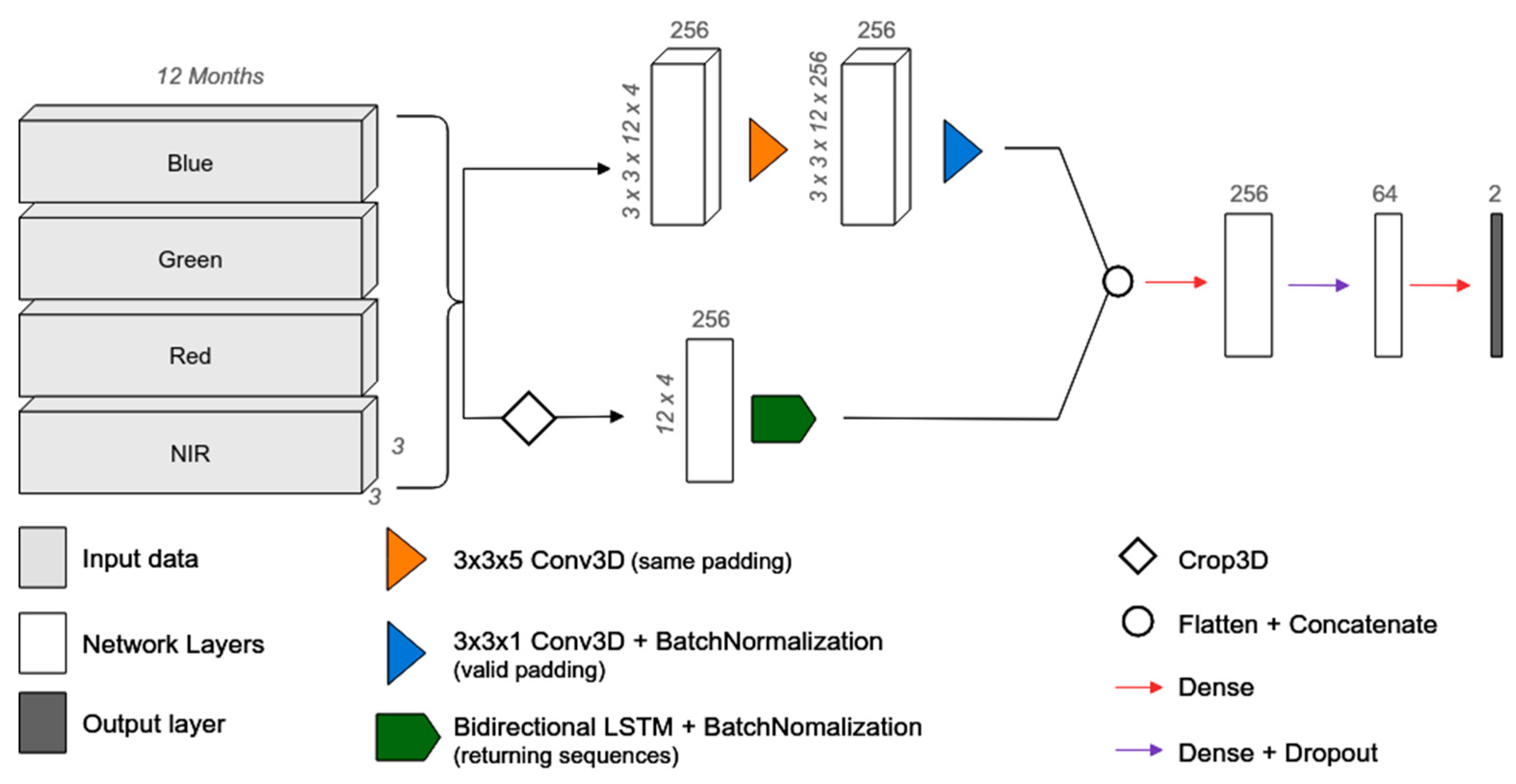
2.4. Long Short-Term Memory Classification
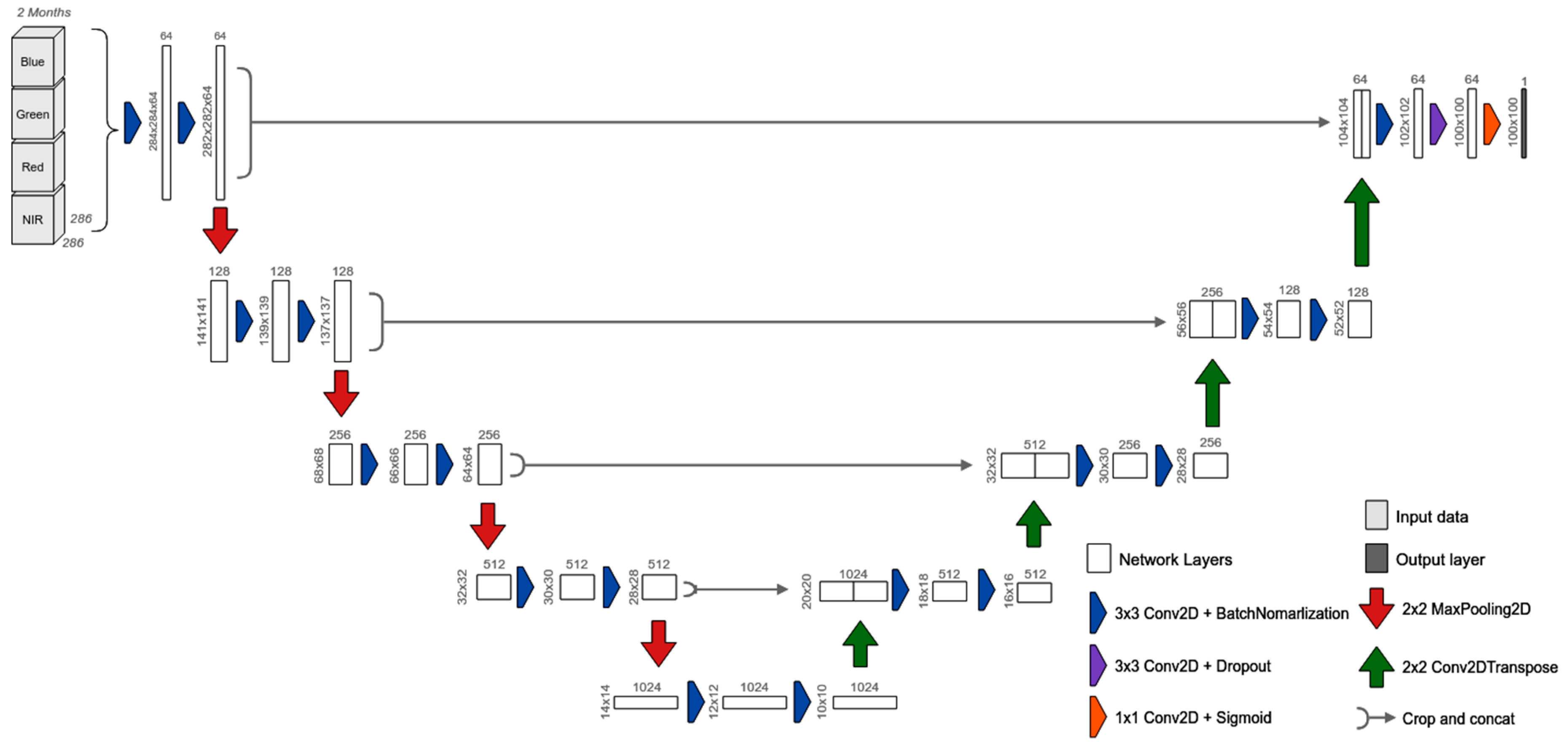
2.5. U-Net Classification
2.6. Accuracy Analysis
3. Results
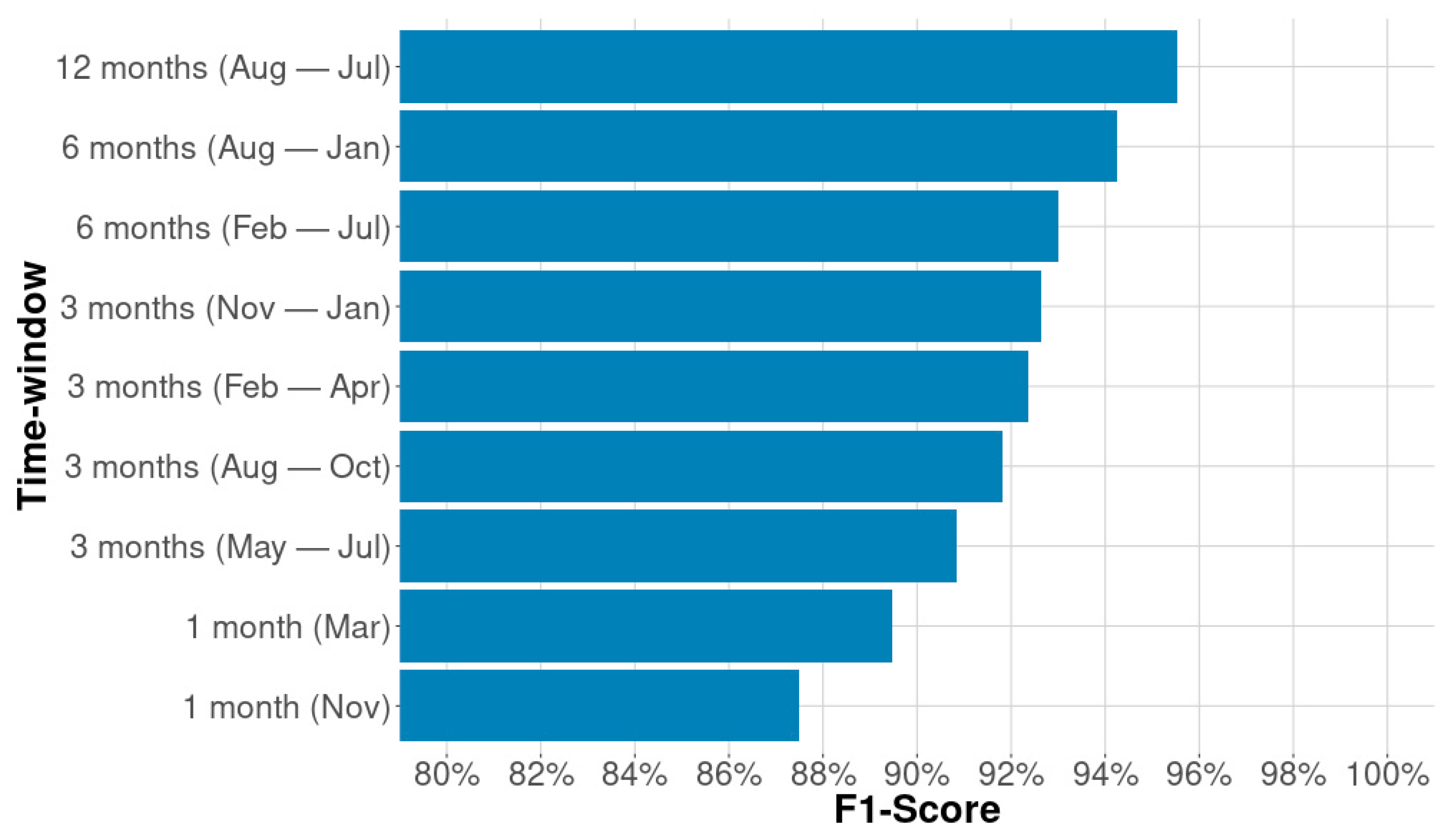
3.1. Feature Engineering
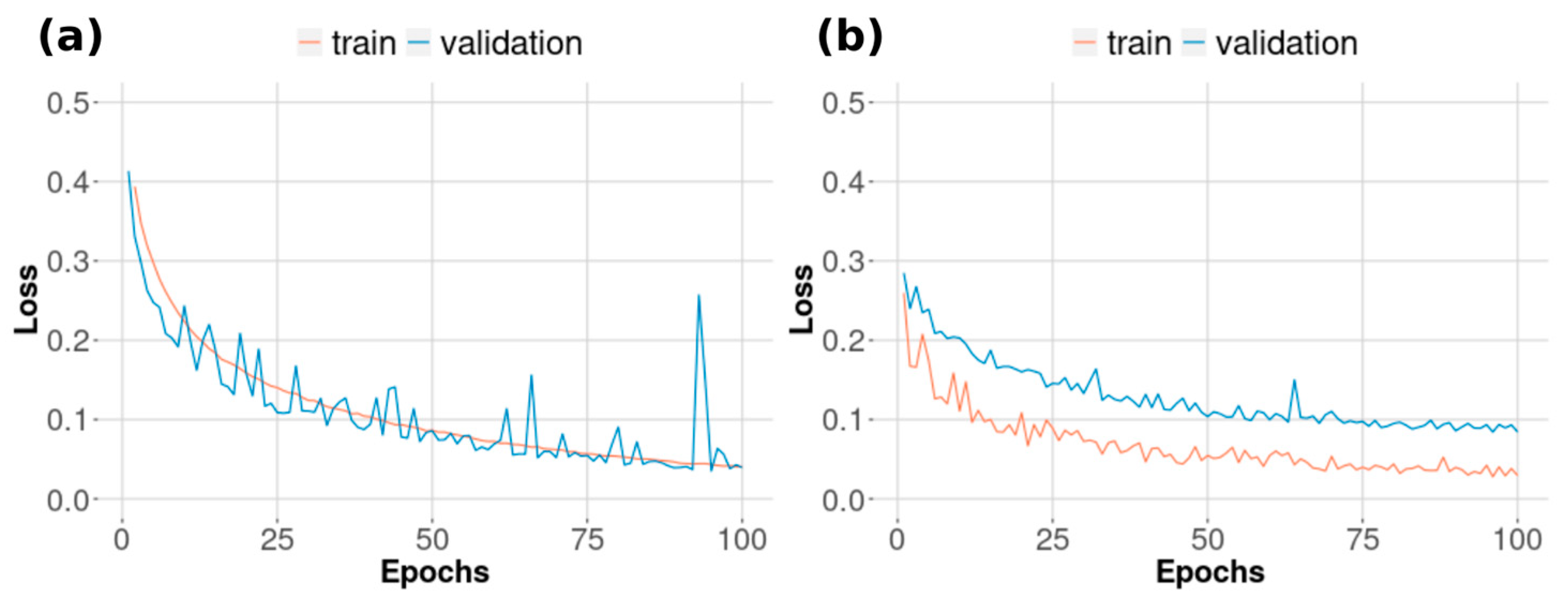
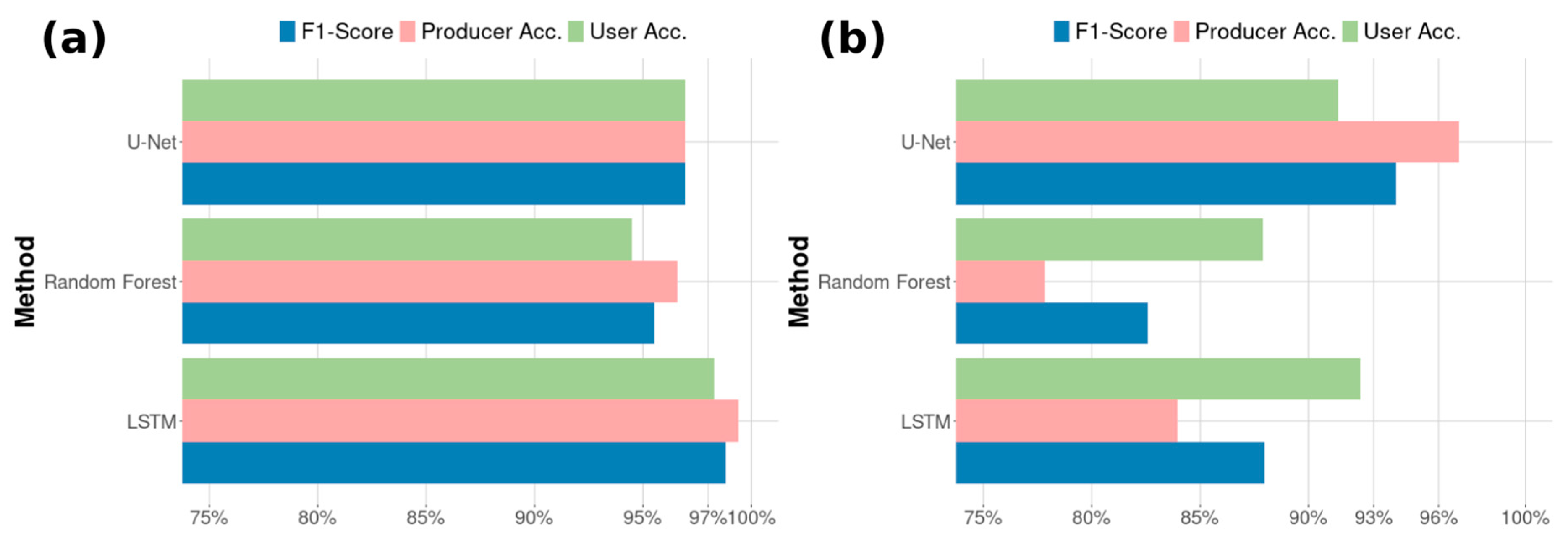
3.2. Training and Prediction Performance
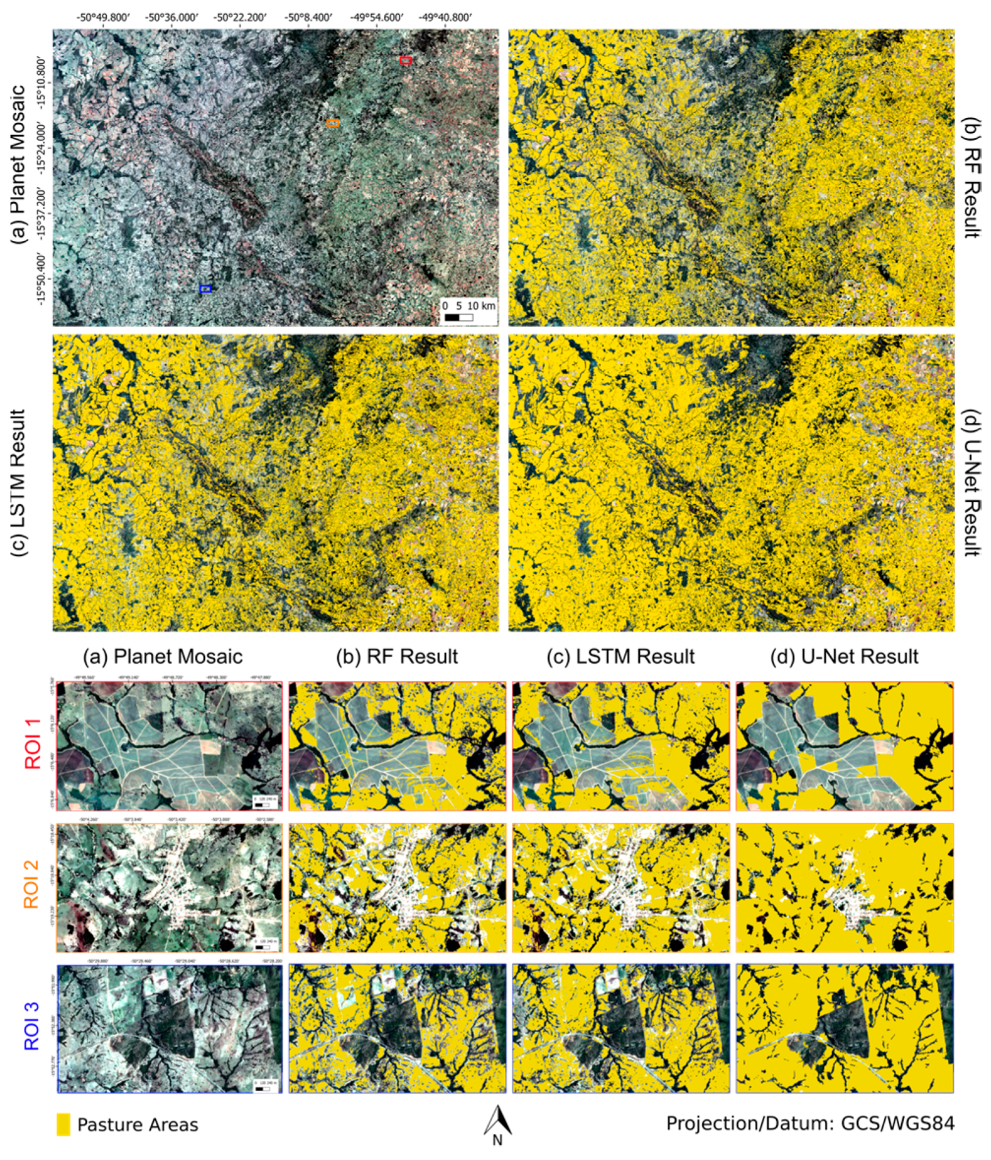
3.3. Pasture Area Mapping
4. Discussion
5. Conclusions
Author Contributions
Funding
Acknowledgments
Conflicts of Interest
References
- Liu, P. A survey of remote-sensing big data. Front. Environ. Sci. 2015, 3, 45. [Google Scholar] [CrossRef] [Scilit]
- Houborg, R.; McCabe, M.F. A Cubesat enabled Spatio-Temporal Enhancement Method (CESTEM) utilizing Planet, Landsat and MODIS data. Remote Sens. Environ. 2018, 209, 211–226. [Google Scholar] [CrossRef] [Scilit]
- Chi, M.; Plaza, A.; Benediktsson, J.A.; Sun, Z.; Shen, J.; Zhu, Y. Big Data for Remote Sensing: Challenges and Opportunities. Proc. IEEE 2016, 104, 2207–2219. [Google Scholar] [CrossRef] [Scilit]
- Nemani, R.; Votava, P.; Michaelis, A.; Melton, F.; Milesi, C. Collaborative supercomputing for global change science. Eos Trans. Am. Geophys. Union 2011, 92, 109–110. [Google Scholar] [CrossRef] [Scilit]
- Gorelick, N.; Hancher, M.; Dixon, M.; Ilyushchenko, S.; Thau, D.; Moore, R. Google Earth Engine: Planetary-scale geospatial analysis for everyone. Remote Sens. Environ. 2017, 202, 18–27. [Google Scholar] [CrossRef] [Scilit]
- Yan, J.; Ma, Y.; Wang, L.; Choo, K.K.R.; Jie, W. A cloud-based remote sensing data production system. Future Gener. Comput. Syst. 2018, 86, 1154–1166. [Google Scholar] [CrossRef] [Scilit]
- Wang, L.; Ma, Y.; Yan, J.; Chang, V.; Zomaya, A.Y. pipsCloud: High performance cloud computing for remote sensing big data management and processing. Future Gener. Comput. Syst. 2018, 78, 353–368. [Google Scholar] [CrossRef] [Scilit]
- Pekel, J.F.; Cottam, A.; Gorelick, N.; Belward, A.S. High-resolution mapping of global surface water and its long-term changes. Nature 2016, 540, 418–422. [Google Scholar] [CrossRef] [Scilit]
- Gong, P.; Wang, J.; Yu, L.; Zhao, Y.; Zhao, Y.; Liang, L.; Niu, Z.; Huang, X.; Fu, H.; Liu, S.; et al. Finer resolution observation and monitoring of global land cover: First mapping results with Landsat TM and ETM+ data. Int. J. Remote Sens. 2013, 34, 2607–2654. [Google Scholar] [CrossRef] [Scilit]
- Hansen, M.C. High-Resolution Global Maps of. Science 2013, 850, 850–854. [Google Scholar] [CrossRef] [Scilit]
- Oliphant, A.J.; Thenkabail, P.S.; Teluguntla, P.; Xiong, J.; Gumma, M.K.; Congalton, R.G.; Yadav, K. Mapping cropland extent of Southeast and Northeast Asia using multi-year time-series Landsat 30-m data using a random forest classifier on the Google Earth Engine Cloud. Int. J. Appl. Earth Obs. Geoinf. 2019, 81, 110–124. [Google Scholar] [CrossRef] [Scilit]
- Xu, Y.; Yu, L.; Feng, D.; Peng, D.; Li, C.; Huang, X.; Lu, H.; Gong, P. Comparisons of three recent moderate resolution African land cover datasets: CGLS-LC100, ESA-S2-LC20, and FROM-GLC-Africa30. Int. J. Remote Sens. 2019, 40, 6185–6202. [Google Scholar] [CrossRef] [Scilit]
- Graesser, J.; Ramankutty, N. Detection of cropland field parcels from Landsat imagery. Remote Sens. Environ. 2017, 201, 165–180. [Google Scholar] [CrossRef] [Scilit]
- Griffiths, P.; Nendel, C.; Hostert, P. Intra-annual reflectance composites from Sentinel-2 and Landsat for national-scale crop and land cover mapping. Remote Sens. Environ. 2019, 220, 135–151. [Google Scholar] [CrossRef] [Scilit]
- Parente, L.; Mesquita, V.; Miziara, F.; Baumann, L.; Ferreira, L. Assessing the pasturelands and livestock dynamics in Brazil, from 1985 to 2017: A novel approach based on high spatial resolution imagery and Google Earth Engine cloud computing. Remote Sens. Environ. 2019, 232, 111301. [Google Scholar] [CrossRef] [Scilit]
- Yan, L.; Roy, D.P. Conterminous United States crop field size quantification from multi-temporal Landsat data. Remote Sens. Environ. 2016, 172, 67–86. [Google Scholar] [CrossRef] [Scilit]
- Hansen, M.C.; Loveland, T.R. A review of large area monitoring of land cover change using Landsat data. Remote Sens. Environ. 2012, 122, 66–74. [Google Scholar] [CrossRef] [Scilit]
- Jordan, M.I.; Mitchell, T.M. Machine learning: Trends, perspectives, and prospects. Science 2015, 349, 255–260. [Google Scholar] [CrossRef] [Scilit]
- Belgiu, M.; Drăgu, L. Random forest in remote sensing: A review of applications and future directions. ISPRS J. Photogramm. Remote Sens. 2016, 114, 24–31. [Google Scholar] [CrossRef] [Scilit]
- Kotsiantis, S.B.; Zaharakis, I.; Pintelas, P. Supervised Machine Learning: A Review of Classification Techniques S. J. Manuf. Sci. Eng. Trans. ASME 2007, 125, 394–395. [Google Scholar]
- Zhong, L.; Hu, L.; Zhou, H. Deep learning based multi-temporal crop classification. Remote Sens. Environ. 2019, 221, 430–443. [Google Scholar] [CrossRef] [Scilit]
- Ma, L.; Liu, Y.; Zhang, X.; Ye, Y.; Yin, G.; Johnson, B.A. Deep learning in remote sensing applications: A meta-analysis and review. ISPRS J. Photogramm. Remote Sens. 2019, 152, 166–177. [Google Scholar] [CrossRef] [Scilit]
- Zhu, X.X.; Tuia, D.; Mou, L.; Xia, G.S.; Zhang, L.; Xu, F.; Fraundorfer, F. Deep Learning in Remote Sensing: A Comprehensive Review and List of Resources. IEEE Geosci. Remote Sens. Mag. 2017, 5, 8–36. [Google Scholar] [CrossRef] [Scilit]
- Lecun, Y.; Bengio, Y.; Hinton, G. Deep learning. Nature 2015, 521, 436–444. [Google Scholar] [CrossRef] [Scilit] [PubMed]
- Chen, Y.; Lin, Z.; Zhao, X.; Wang, G.; Gu, Y. Deep learning-based classification of hyperspectral data. IEEE J. Sel. Top. Appl. Earth Obs. Remote Sens. 2014, 7, 2094–2107. [Google Scholar] [CrossRef] [Scilit]
- Gerke, M. Use of the Stair Vision Library within the ISPRS Use of the Stair Vision Library within the ISPRS 2D; ResearcheGate: Berlin, Germany, 2015. [Google Scholar]
- Yang, Y.; Newsam, S. Bag-Of-Visual-Words and Spatial Extensions for Land-Use Classificatio. In Proceedings of the 18th SIGSPATIAL International Conference on Advances in Geographic Information Systems, San Jose, CA, USA, 2–5 November 2010. [Google Scholar]
- Stoian, A.; Poulain, V.; Inglada, J.; Poughon, V.; Derksen, D. Land Cover Maps Production with High Resolution Satellite Image Time Series and Convolutional Neural Networks: Adaptations and Limits for Operational Systems. Remote Sens. 2019, 11, 1986. [Google Scholar] [CrossRef] [Scilit]
- Maulik, U.; Chakraborty, D. Remote Sensing Image Classification: A survey of support-vector-machine-based advanced techniques. IEEE Geosci. Remote Sens. Mag. 2017, 5, 33–52. [Google Scholar] [CrossRef] [Scilit]
- Stehman, S.V.; Foody, G.M. Key issues in rigorous accuracy assessment of land cover products. Remote Sens. Environ. 2019, 231, 111199. [Google Scholar] [CrossRef] [Scilit]
- Liu, P.; Yuan, T.; Ma, Y.; Wang, L.; Liu, D.; Yue, S.; Kołodziej, J. Parallel processing of massive remote sensing images in a GPU architecture. Comput. Inform. 2014, 33, 197–217. [Google Scholar]
- Ma, Y.; Chen, L.; Liu, P.; Lu, K. Parallel programing templates for remote sensing image processing on GPU architectures: Design and implementation. Computing 2016, 98, 7–33. [Google Scholar] [CrossRef] [Scilit]
- Parente, L.; Ferreira, L.; Faria, A.; Nogueira, S.; Araújo, F.; Teixeira, L.; Hagen, S. Monitoring the brazilian pasturelands: A new mapping approach based on the landsat 8 spectral and temporal domains. Int. J. Appl. Earth Obs. Geoinf. 2017, 62, 135–143. [Google Scholar] [CrossRef] [Scilit]
- Saraiva, M.; Silva, D.; Ferreira, L.; Galano, S.; Siqueira, J.; Souza, C., Jr. Construção De Mosaicos Temporais Normalizados De Imagens Planet. In Proceedings of the XIX Brazilian Symposium on Remote Sensing; INPE: Santos, Brazil, 2019; pp. 3053–3056. [Google Scholar]
- Breiman, L. Random forests. Mach. Learn. 2001, 45, 5–32. [Google Scholar] [CrossRef] [Scilit]
- Schmidhuber, J.; Hochreiter, S. Long short-term memory. Neural Comput. 1997, 9, 1735–1780. [Google Scholar]
- Ronneberger, O.; Fischer, P.; Brox, T. U-net: Convolutional networks for biomedical image segmentation. Lect. Notes Comput. Sci. 2015, 9351, 234–241. [Google Scholar]
- IBGE. Mapas e Outros Materiais Cartográficos na Biblioteca Central do IBGE; Diretoria de Formação e Aperfeiçoamento de Pessoal, B.C., Ed.; IBGE: Rio de Janeiro, Brazil, 1983; Volume 2, ISBN 8524000112. [Google Scholar]
- Teodoro, A.C.; Araujo, R. Comparison of performance of object-based image analysis techniques available in open source software (Spring and Orfeo Toolbox/Monteverdi) considering very high spatial resolution data. J. Appl. Remote Sens. 2016, 10, 016011. [Google Scholar] [CrossRef] [Scilit]
- Jaya, M.T.S.; Fajar, A.N. Analysis of The Implementation Quantum GIS: Comparative Rffect and User Performance. J. Theor. Appl. Inf. Technol. 2019, 97, 2596–2605. [Google Scholar]
- Huete, A.R.; Liu, H.Q.; Van Leeuwen, W. A Comparison of Vegetation Indices over a Global Set of TM Images for EOS-MODIS. Remote Sens. Environ. 1997, 59, 440–451. [Google Scholar] [CrossRef] [Scilit]
- Gamon, J.A.; Serrano, L.; Surfus, J.S. The photochemical reflectance index: An optical indicator of photosynthetic radiation use efficiency across species, functional types, and nutrient levels. Oecologia 1997, 112, 492–501. [Google Scholar] [CrossRef] [Scilit]
- Mcfeeters, S.K. The use of the Normalized Difference Water Index (NDWI) in the delineation of open water features. Int. J. Remote Sens. 1996, 17, 1425–1432. [Google Scholar] [CrossRef] [Scilit]
- Parente, L.; Ferreira, L. Assessing the spatial and occupation dynamics of the Brazilian pasturelands based on the automated classification of MODIS images from 2000 to 2016. Remote Sens. 2018, 10, 606. [Google Scholar] [CrossRef] [Scilit]
- Wan, S.; Chang, S.H. Crop classification with WorldView-2 imagery using Support Vector Machine comparing texture analysis approaches and grey relational analysis in Jianan Plain, Taiwan. Int. J. Remote Sens. 2019, 40, 8076–8092. [Google Scholar] [CrossRef] [Scilit]
- Li, W.; He, C.; Fang, J.; Zheng, J.; Fu, H.; Yu, L. Semantic segmentation-based building footprint extraction using very high-resolution satellite images and multi-source GIS data. Remote Sens. 2019, 11, 403. [Google Scholar] [CrossRef] [Scilit]
- Ioffe, S.; Szegedy, C. Batch normalization: Accelerating deep network training by reducing internal covariate shift. arXiv 2015, arXiv:1502.03167. [Google Scholar]
- Srivastava, N.; Hinton, G.; Krizhevsky, A.; Sutskever, I.; Salakhutdinov, R. Dropout: A Simple Way to Prevent Neural Networks from Overfitting. J. Mach. Learn. Res. 2014, 15, 345–350. [Google Scholar]
- Dozat, T. Incorporating Nesterov Momentum into Adam. In Proceedings of the ICLR Workshop, San Juan, Puerto Rico, 2–4 May 2016. [Google Scholar]
- Dong, S.; Kaeli, D. DNNMark: A deep neural network benchmark suite for GPUs. In Proceedings of the General Purpose GPUs, Austin, TX, USA, 4–8 February 2017; pp. 63–72. [Google Scholar]
- Abadi, M.; Barham, P.; Chen, J.; Chen, Z.; Davis, A.; Dean, J.; Devin, M.; Ghemawat, S.; Irving, G.; Isard, M.; et al. TensorFlow: A System for Large-Scale Machine Learning. In Proceedings of the 12th Symposium on Operating Systems Design and Implementation, Savannah, GA, USA, 2–4 November 2016; p. 44. [Google Scholar]
- Qin, C.Z.; Zhan, L.J.; Zhu, A.X. How to Apply the Geospatial Data Abstraction Library (GDAL) Properly to Parallel Geospatial Raster I/O? Trans. GIS 2014, 18, 950–957. [Google Scholar] [CrossRef] [Scilit]
- Jaiswal, S.; Mehta, A.; Nandi, G.C. Investigation on the Effect of L1 an L2 Regularization on Image Features Extracted using Restricted Boltzmann Machine. In Proceedings of the Second International Conference on Intelligent Computing and Control Systems (ICICCS), Madurai, India, 14–15 June 2019; pp. 1548–1553. [Google Scholar]
- Rahman, M.A.; Wang, Y. Optimizing intersection-over-union in deep neural networks for image segmentation. In International Symposium on Visual Computing; Springer: Cham, Switzerland, 2016; pp. 234–244. [Google Scholar]
- Hadad, O.; Bakalo, R.; Ben-Ari, R.; Hashoul, S.; Amit, G. Classification of breast lesions using cross-modal deep learning. In Proceedings of the IEEE 14th International Symposium on Biomedical Imaging (ISBI 2017), Melbourne, Australia, 18–21 April 2017; pp. 109–112. [Google Scholar]
- Lemaître, G.; Nogueira, F.; Aridas, C.K. Imbalanced-learn: A Python Toolbox to Tackle the Curse of Imbalanced Datasets in Machine Learning. J. Mach. Learn. Res. 2016, 18, 559–563. [Google Scholar]
- Sidorova, V.S. Detecting clusters of specified separability for multispectral data on various hierarchical levels. Pattern Recognit. Image Anal. 2014, 24, 151–155. [Google Scholar] [CrossRef] [Scilit]
- Foody, G.M.; Mathur, A. The use of small training sets containing mixed pixels for accurate hard image classification: Training on mixed spectral responses for classification by a SVM. Remote Sens. Environ. 2006, 103, 179–189. [Google Scholar] [CrossRef] [Scilit]
- Berhane, T.M.; Costa, H.; Lane, C.R.; Anenkhonov, O.A.; Chepinoga, V.V.; Autrey, B.C. The influence of region of interest heterogeneity on classification accuracy in wetland systems. Remote Sens. 2019, 11, 551. [Google Scholar] [CrossRef] [Scilit]
- Lhermitte, S.; Verbesselt, J.; Jonckheere, I.; Nackaerts, K.; van Aardt, J.A.N.; Verstraeten, W.W.; Coppin, P. Hierarchical image segmentation based on similarity of NDVI time series. Remote Sens. Environ. 2008, 112, 506–521. [Google Scholar] [CrossRef] [Scilit]
- Zhang, X.; Xiao, P.; Feng, X.; Yuan, M. Separate segmentation of multi-temporal high-resolution remote sensing images for object-based change detection in urban area. Remote Sens. Environ. 2017, 201, 243–255. [Google Scholar] [CrossRef] [Scilit]
- Simpson, J.J.; MeIntire, T.J.; Berg, J.S.; Tsou, Y.L. The Parallel Image Processing Environment (PIPE): Automated parallelization of satellite data analyses. Concurr. Comput. Pract. Exp. 2007, 19, 685–701. [Google Scholar] [CrossRef] [Scilit]



| LULC Class | Polygons | Pixels (4 m) | Min. Distance | Point Samples | ||||
|---|---|---|---|---|---|---|---|---|
| Class | Subclass | Quantity | Percent | Quantity | Percent | Subclass | Class | |
| Non-pasture | Sand Bank | 50 | 3.77% | 9764 | 1.04% | 6.205 | 1500 | 15,000 |
| Planted Forest | 36 | 2.71% | 32,871 | 3.51% | 14.725 | 1500 | ||
| Water | 89 | 6.71% | 36,684 | 3.92% | 15.781 | 1500 | ||
| Urban Area | 143 | 10.78% | 55,839 | 5.97% | 20.405 | 1500 | ||
| Deforestation | 145 | 10.94% | 69,821 | 7.46% | 23.290 | 1500 | ||
| Others | 85 | 6.41% | 131,552 | 14.06% | 33.460 | 1500 | ||
| Forest Formation | 111 | 8.37% | 116,957 | 12.50% | 31.321 | 1500 | ||
| Savannah Formation | 140 | 10.56% | 131,422 | 14.04% | 33.441 | 1500 | ||
| Crop | 234 | 17.65% | 178,509 | 19.07% | 39.636 | 1500 | ||
| Pasture | Regular Pasture | 42 | 3.17% | 42,213 | 4.51% | 9.420 | 3750 | 15,000 |
| Wet Pasture | 87 | 6.56% | 52,951 | 5.66% | 11.031 | 3750 | ||
| Pasture with bare soil | 39 | 2.94% | 33,226 | 3.55% | 7.906 | 3750 | ||
| Pasture with shrubs | 125 | 9.43% | 44,034 | 4.71% | 9.707 | 3750 | ||
| Total | 1326 | 100.00% | 935,843 | 100.00% | 30,000 | |||
| # | Training Data | Predicted Data | ||
|---|---|---|---|---|
| U-Net | LSTM | U-Net | LSTM | |
| Data chunk | 1440 | 27,000 | 116,183 | 1,161,832,926 |
| Augmentation cases | 8 | - | - | - |
| Height | 286 | 3 | 286 | 3 |
| Width | 286 | 3 | 286 | 3 |
| Spectral Bands | 4 | 4 | 4 | 4 |
| Times | 2 | 12 | 2 | 12 |
| Total (million pixels) | 7538 | 12 | 76,027 | 501,912 |
© 2019 by the authors. Licensee MDPI, Basel, Switzerland. This article is an open access article distributed under the terms and conditions of the Creative Commons Attribution (CC BY) license (http://creativecommons.org/licenses/by/4.0/).
Share and Cite
Parente, L.; Taquary, E.; Silva, A.P.; Souza, C.; Ferreira, L. Next Generation Mapping: Combining Deep Learning, Cloud Computing, and Big Remote Sensing Data. Remote Sens. 2019, 11, 2881. https://doi.org/10.3390/rs11232881
Parente L, Taquary E, Silva AP, Souza C, Ferreira L. Next Generation Mapping: Combining Deep Learning, Cloud Computing, and Big Remote Sensing Data. Remote Sensing. 2019; 11(23):2881. https://doi.org/10.3390/rs11232881
Chicago/Turabian StyleParente, Leandro, Evandro Taquary, Ana Paula Silva, Carlos Souza, and Laerte Ferreira. 2019. "Next Generation Mapping: Combining Deep Learning, Cloud Computing, and Big Remote Sensing Data" Remote Sensing 11, no. 23: 2881. https://doi.org/10.3390/rs11232881
APA StyleParente, L., Taquary, E., Silva, A. P., Souza, C., & Ferreira, L. (2019). Next Generation Mapping: Combining Deep Learning, Cloud Computing, and Big Remote Sensing Data. Remote Sensing, 11(23), 2881. https://doi.org/10.3390/rs11232881