Article

What Drives Crop Land Use Change during Multi-Year Droughts in California’s Central Valley? Prices or Concern for Water?

by
Mekonnen Gebremichael
1,*,
P. Krishna Krishnamurthy
2,
Lula T. Ghebremichael
3 and
Sarfaraz Alam
1
1
Department of Civil and Environmental Engineering, University of California, Los Angeles, CA 90095-1593, USA
2
Institute of the Environment and Sustainability, University of California, La Kretz Hall, 619 Charles E Young Dr E #300, Los Angeles, CA 90024, USA
3
Syngenta Crop Protection LLC, P.O. Box 18300, Greensboro, NC 27419, USA
*
Author to whom correspondence should be addressed.
Remote Sens. 2021, 13(4), 650; https://doi.org/10.3390/rs13040650
Submission received: 16 December 2020 / Revised: 4 February 2021 / Accepted: 8 February 2021 / Published: 11 February 2021

Abstract

:
The recent multi-year droughts in California have highlighted the heightened risk of longer and more intense droughts, thus increasing the interest in understanding potential impacts for major economic activities, such as agriculture. This study examines changes in cropping pattern in California’s Central Valley between 2007 and 2016 in response to two consecutive droughts (2007–2009 and 2012–2016), factors driving these changes, and the impact of these changes on groundwater level. Results indicate that Central Valley experienced a shift in cropping pattern from alfalfa, cereals (rice, winter wheat, corn, and oats), and cotton, to nut (almonds, walnuts, and pistachios) and fruit (grapes, oranges, and tomatoes) tree crops. This shift in cropping pattern was likely driven by high crop prices, increasing trend in crop price, and increasing water pumping cost, particularly in the relatively water-stressed southern parts of Central Valley. While the total cropland water use for Central Valley remained the same during 2007–2016 (during both wet and dry years), they vary from county to county. Some counties experienced large reductions in cropland water use, while other counties experienced large increases in cropland water use, indicating the need for county-specific water resource management. The results also indicate that both land management (determining size of fallow land), as well as crop management (choice of crop types), are key factors in water resource management.

Graphical Abstract

1. Introduction

The potential for more frequent, intense, and severe droughts under future climate change is a concern [1]. The impacts of drought risk on agriculture and water security are significant, as illustrated by the loss of crops and extreme water stress associated with recent droughts in Russia [2], Syria [3], the Horn of Africa [4], the U.S. Midwest [5], Southeast Asia [6], Cape Town drought [7], and the consecutive multi-year droughts in California [8]. These events highlight the ubiquity of drought and the potential catastrophic impacts—not only locally but also at regional and global scales.
The last decade in California had been marked by eight abnormally dry years over two drought periods: 2007–2009 (hereafter referred to as Drought 1) and 2012–2016 (Drought 2), with a period in 2010–2011 of normal weather conditions (see Figure 1). The latter drought was the most severe drought in recorded history, with records set for the 12-month precipitation average [1], the highest temperatures in more than 1200 years [9], the lowest snowpack in 500 years [10], and the period with the most extreme drought indicators [11]. Geographically, the 2012–2016 drought affected the entire State of California, with more than two-third experiencing extreme or exceptional drought conditions between 2014 and 2016. The occurrence of consecutive multi-year droughts within a short period in California offers an unprecedented opportunity to examine the impacts of more severe droughts, as is projected under future climate change scenarios [1].
California’s Central Valley is one of the world’s largest and economically most important regions with irrigated agriculture. The region produces more than 50% of all fruits, nuts and vegetables grown in the U.S, and is also the predominant producer (accounting for 99% of national production) of highly nutritious specialty crops, such as almonds, pistachios, and grapes. It hosts approximately 75% of the irrigated land in California and 17% of the Nation’s irrigated land [8,13,14]. It also has one of the highest concentrations of endangered species in the country [15].
Previous studies examined some aspects of land use changes, driving factors, and impacts on groundwater during 2007–2016 in Central Valley. During this period, increases in fallow land area and reductions in irrigated land were reported [8,16,17]. Studies also reported a reduction in acreage for alfalfa, cereals, and cotton, and an increase in acreage for nut and fruit tree crops [18,19,20]. This shift in cropping pattern was attributed to higher crop prices for nut and fruit tree crops [21,22]. Almonds (the most dominant nut in the region) were reported to have the highest direct economic value in terms of dollars per kilogram, compared to other crops growing on the region [23]. The shift in cropping pattern was reported to have caused an increase in crop water use per hectare [19]. The surface water in Central Valley during the 2014 drought was reduced by 8 billion cubic meter, of which 6.2 billion cubic meter was replaced through pumping of groundwater, causing dramatic depletion of groundwater [8]. This groundwater overdraft led to higher pumping costs [8], poorer water quality [24], decreased well yields [25], and land subsidence that puts state and federal aqueducts and flood control structures at risk of damage [26]. Groundwater has been reportedly declining over the past decades (3 km3/year on average during 1950–2009), and, in the absence of future mitigating measures, this decline will likely continue, but at a higher rate due to climate change [27]. Water deliveries to Central Valley from Colorado River will become unsustainable toward the end of this Century due to declining snowpack in the western United States [28,29]. It is also important to include irrigation rates in current climate models to more realistically simulate regional water cycle dynamics in Central Valley [30].
In an effort to address the ongoing severe groundwater depletion problem in the region, California, for the first time in its history, passed the Sustainable Groundwater Management Act (SGMA) in 2014, regulating the use of groundwater resources. SGMA requires local agencies to halt overdraft and bring groundwater basins into balanced levels of pumping and recharge by 2040 for critically overdrafted groundwater basins, and by 2042 for high and medium priority basins [31]. Most of the overdrafted basins in the State occur within the southern part of the Central Valley, whereas high and medium priority groundwater basins dominate the northern part of the Central valley. Currently, an active area of research and implementation is the identification of feasible water and land management solutions at the groundwater basin or county level. Most of the studies reviewed above treat Central Valley as one unit and therefore, do not take into account the existing huge spatial variability in hydrometeorology and groundwater systems within the Valley. There is a need to understand water and land management issues and explore possible solutions at the county scale, where practical actions are taken.
The purpose of this study is to examine the changes in crop acreage during the 2007–2016 period, both at Central Valley and smaller administration units (county) levels within the Valley, and assess potential drivers and impact on groundwater resources. The paper is structured as follows. First, the study region, datasets, and methodology are provided. Then, the changes in crop acreages both at the Central Valley level and county level are presented. This will be followed by the discussion of price trends, and their associations with trends in crop acreage. Next, changes in groundwater levels during both drought periods are displayed, and their associations with crop acreage changes are discussed. Finally, we close the paper with conclusions.

2. Methodology

2.1. Central Valley, California

California’s Central Valley extends approximately 640 km north to south and on average 64 km across, bordered on the east by the Sierra Nevada foothills and on the west by the Coast Ranges (Figure 2). The Valley generally has low relief and is surrounded by high-elevation watersheds in the Sierra Nevada. The Central Valley consists of the Sacramento Valley in the north and the San Joaquin Valley in the south (Figure 2c). The Sacramento Valley (SV) consists of ten counties: Butte, Colusa, Glenn, Placer, Sacramento, Shasta, Sutter, Tehama, Yolo, and Yuba. The San Joaquin Valley consists of eight counties: Fresno, Kern, Kings, Madera, Merced, San Joaquin, Stanislaus, and Tulare. The Central Valley has a hot Mediterranean climate in the north; the southern parts of the region are dry and categorized as desert. The long-term rainfall map (Figure 2d) shows a strong precipitation gradient from the headwater watersheds to the valley floors, and from the northern part (mostly semi-humid) to the southern part (mostly semi-arid) of the region. The north-south contrast in water demand and supply motivated the construction of the Central Valley Project and State Water Project aqueducts that transfer water from the Delta to the south via hundreds of miles of aqueducts. Most of the precipitation across the entire Central Valley falls during the period of November to March, while irrigation demand is mostly in the summer (July to September). This mismatch is mitigated by some 18 major headwater reservoirs (locations shown as circles in Figure 2c), which store winter flows for release during the summer [27]. During recent droughts, surface water deliveries to agriculture ranged from 0% to 30% of contracted amounts [32]. Groundwater pumping increased as a result, amplifying the trend of long-term overdraft [33].

2.2. Datasets

Crop acreage data were obtained from the Cropland Data Layer (CDL) products. The CDL is a high-resolution (30 m) national land cover dataset that provides crop-level information on a yearly basis. The CDL, available from 2007 to date, were generated from the Landsat satellite missions by the United States Department of Agriculture/National Agricultural Statistics Service (USDA/NASS) CropScape project (https://nassgeodata.gmu.edu/CropScape/). The CDL datasets include up to 141 land use classes, 117 of which are agricultural classes. The National Academy of Sciences has recommended the CDL data as the best available crop and land cover information over the United States [34]. While the CDL datasets are consistent in their accuracy and are not prone to errors that arise from alternative methods, such as ground surveying, they are still subject to uncertainties that result from the nature of land cover classification based on satellite remote sensing data. In an effort to reduce the errors, we have averaged the 30-m datasets to county and Valley levels, and also focused on long-term trends and variations over a 10-year period. A recent study [8] compared crop acreage trends obtained from the CDL datasets and ground-based survey data for Kern county and reported good agreement between the resulting trends.
Crop price data were obtained for the State of California from the USDA/NASS QuickStats Service [35]. Data are based on annual averages and adjusted for inflation. Crop yield data were obtained from the USDA/NASS QuickStats database (https://quickstats.nass.usda.gov/), a comprehensive dataset compiling agricultural data from the United States. This dataset is considered the most reliable for crop yield estimates [36]. In California, data are available since the early 1990s for over 100 crops at the state level, but are only available at the county level for some crops and counties. Given the difficulty of obtaining data at the county-level, analysis of crop yields was conducted at the state level. The crop yield data were analyzed to assess how the trends in crop acreage change would translate to the total crop production: for example, a decreasing crop acreage trend with increasing crop yield trend would result in stable crop production. Mean crop water use estimates for Central valley were obtained from Landsat-derived actual evapotranspiration estimates provided by Reference [19]. The crop water use estimates were used to analyze the potential impact of crop acreage change on crop water demand. Groundwater level data were obtained from CASGEM (California Statewide Groundwater Elevation Monitoring) (https://water.ca.gov/Programs/Groundwater-Management). This includes seasonal and long-term groundwater level measurement by the California Department of Water Resources. Data is available for wells serving various purposes, e.g., irrigation, domestic, and monitoring/observation. We used data from the observation wells to assess the groundwater changes during the drought years.

2.3. Approach

Our first step was to identify the most dominant crops in Central Valley by calculating the long-term (2007–2016) average acreage for each crop type. The following 12 crops collectively accounted for, on average, 95% of the total active/used cropland area in Central Valley: almonds (21%), alfalfa (15%), grapes (10%), rice (10%), winter wheat (9%), walnuts (7%), cotton (6%), corn (5%), tomatoes (4%), pistachios (3%), oranges (3%), and oats (2%). We consider that, given their total contribution to land use, these crops provide a useful baseline to understand impacts of the multi-year droughts in California. In addition, we included the total active cropland area, the fallow/idle land area, the pasture/grassland, and the forest land to enable a more comprehensive analysis of land use change.
The second step in our approach was to examine the 2007–2016 annual time series of crop acreage at the Central Valley level for each dominant crop type. The time-series analysis was made through visual observations of the time series graph, fitting a linear trend model, and performing the Mann-Kendall (MK) test for trend analysis. The linear regression analysis requires that the residuals from the fitted regression line be normally distributed. We used the Fisher’s Transformation [37] to estimate the standard error of the coefficient of determination (R2) estimate. The MK test, on the other hand, does not require the assumption of data normality, as it is a non-parametric test [38]. The MK test has been used to test the trend in crop water use in Central Valley [19]. Although our sample size (11 years, 2007–2016) meets the minimum number (at least 8 to 10) of recommended samples for MK test [39], the lower sample size may compromise the quality of the test to detect a statistically significant trend in some crops. In cases where there would be expansion of crop acreage, we also brought yearly crop yield data to see if there was any compromise in crop yield due to drought. The third step in our approach was to compute the change in crop acreage for each county, by taking the difference in crop acreage between the ending and beginning years of the study period (2016 and 2007). This step would reveal the magnitude of crop acreage change for each crop type on a county level.
Next, we examined the possible role of crop price in explaining the trend in crop acreage data. We performed time-series analysis of the crop price data, and compared the resulting trends to trends in crop acreage data. Anticipating that crop price increases may be important to offset increasing costs in water extraction (pumping) cost, we computed the change in groundwater head for several groundwater well locations. Finally, we assessed the possible impact of crop acreage trend on crop water use, by using crop-specific crop water use computed for the region by Reference [19].

3. Results and Discussion

3.1. Trends in Crop Acreage at Central Valley Level

Figure 3 shows the time series (and fitted linear trend and significance test results) of active cropland, fallow cropland, and pasture and forest areas. Figure 4 and Figure 5 display the time series of acreages (as well as crop yield and crop price) for each of the 12 dominant crop types. Figure 6 presents the percentage change in crop acreage in 2016 relative to 2007, for each crop type.
Active/Used Cropland Area: The active cropland acreage in Central Valley averaged at 2.3 million ha during the 2007–2016 period and remained relatively stable with no statistically significant linear trend according to the Mann-Kendall test (Figure 3a). Compared to 2007, the active cropland acreage showed a slight reduction by 57,000 ha (or 2.6%). Approximately, three-fourths of the Central Valley cropland area were located in San Joaquin Valley.
Fallow/Idle Cropland Area: Although cropland area remained stable, fallow land acreage in Central Valley sharply increased (with statistical significance, p < 0.05), and tripled during the 10-year period, from about 180,000 ha in 2007 to 450,000 ha in 2016 (Figure 3b). Both San Joaquin and Sacramento Valleys showed statistically significant increasing trends. The fallow land increment rate for San Joaquin Valley was twice as much as for Sacramento, which could be attributed to the relatively more severe water shortage problem in San Joaquin Valley [17].
Conversion to Cropland: The increased fallowed land, while the active cropland was about the same, indicates that additional cropland was gained through conversion of land used previously for other purposes, such as conversion of oak woodlands to vineyards [40]. To assess the source of land conversion, we looked at the time series of pasture/grass land and forest in Central Valley (Figure 3c). The forest land did not show any decreasing trend. However, we see a decreasing trend for the pasture land acreage with moderate coefficient of determination (R2 = 0.46 ± 0.07), although the confidence is slightly lower (p = 0.1). Therefore, the conversion to cropland possibly came from pastureland [41].
Crop-Specific Acreages: In the following sections, we describe the trend in crop-specific acreages. The time series of crop-specific acreages is presented in Figure 4a–f and Figure 5a–f, with crops ordered according to their dominance by acreage. In addition, shown in Figure 4g–l and Figure 5g–l are crop yield per hectare. For our discussion, we have grouped the crops into two categories: perennial (almond, alfalfa, walnut, pistachios, oranges, grapes) and annual (cotton, rice, oats, corn, wheat, tomatoes).
Perennial Crops: The perennial crops in Central Valley discussed below consist of tree nuts (almond, walnut, and pistachios), fruit crops (oranges and grapes), and alfalfa.
With an acreage of about 400,000 ha in 2007, almonds were the second dominant crop (alfalfa being in the first place) in Central Valley, representing 18% of the Valley’s total cultivated cropland. In 2016, almond acreage increased to 600,000 ha, accounting for 28% of the Valley’s total cultivated cropland acreage, and overtaking alfalfa as the most dominant crop in the Valley (Figure 6). According to the 2007–2016 time-series plot (Figure 4), almond acreage showed a statistically significant increasing trend. The majority of the almond acreage (85% in 2007, and 83% in 2016) was located in San Joaquin Valley, where water resources are limited compared to Sacramento Valley. Almonds were the most dominant crop each year in San Joaquin Valley. In contrast, in Sacramento county, almonds were the fourth dominant crop in 2007 (after rice, alfalfa, and walnuts), and the second dominant crop in 2016 (after rice). Walnuts were ranked eighth by acreage in 2007 with an acreage of 121,000 ha, and their acreage increased to 168,000 ha in 2016, taking the fifth rank (Figure 6). According to the Mann-Kendall test, the walnut acreage showed a statistically significant increasing trend during the 2007–2016 (Figure 4). Walnut acreages were spread equally in both Sacramento and San Joaquin Valleys. Pistachios were ranked tenth in 2007 with an acreage of 60,000 ha, and their acreages doubled in 2016, taking fifth rank (Figure 6). Pistachio acreage showed a statistically significant increasing trend during the 2007–2016 period (Figure 5). The pistachios were predominantly (98%) grown in San Joaquin Valley. The crop production is a function of not only crop acreage but also crop yield. The trend in crop yield per hectare (Figure 4g–l and Figure 5g–l) showed mixed results: no-trend for almonds and pistachios (with the exception of 2015 for pistachios), and increasing trend for walnuts. Therefore, the increase in tree nut crop would overall translate to increase in tree nut production. Many additional factors including pollination, dormancy, and crop infection may jointly contribute to crop yield [42]. For example, almond trees are considered as moderately alternate bearing crops, and, as such, they may have a higher yield in one year followed by lower yield the next year [43]. The record-low crop yield for pistachio in 2015 was attributed to lower chill hour in that year [44].
With regard to perennial fruit crops, grape acreage was 242,000 ha in 2007, ranking fourth, and increased to 304,000 ha in 2016, jumping to second place (Figure 6). Grape acreage showed a statistically significant increasing trend during the 2007–2016 period (Figure 4). Grape was predominantly (over 90%) grown in San Joaquin Valley. The other fruit crop, orange, had the lowest acreage (19,000 ha) of all counties in 2007 but saw its acreage tripled to 57,000 ha (Figure 6). During the 2007–2016 period, the orange acreage showed an increasing trend with moderate coefficient of determination value but with a relatively lower confidence due to p-value around 0.3 (Figure 5). Almost all orange acreages were located in San Joaquin Valley. Grape had a stable crop yield during the study period, while orange had high fluctuations.
The perennial crop that did not follow the acreage trends of nuts and fruit crops was alfalfa. Alfalfa was one of the dominant crops in Central Valley, with an acreage of 411,000 ha in 2007 ranking as the top dominant crop by acreage. However, its importance decreased over time, as its acreage reduced to 240,000 ha, falling to third place, after almonds and grapes (Figure 6). During the 2007–2016 period, alfalfa acreage showed a decreasing trend but with stable yield (Figure 4). The majority (82%) of alfalfa acreage was located in San Joaquin Valley.
Annual Crops: The annual crops discussed below consist of cereals (rice, oats, corn, winter wheat), cotton, and tomatoes.
Rice was the third dominant crop in 2007 with an acreage of 247,000 ha. Its acreage slightly reduced to 225,000 ha, dropping to fourth place (Figure 6). During the 2007–2016 period, rice saw a slightly decreasing trend (Figure 4). The rice acreage was low at the peak of the drought periods (2008 during drought 1, and 2014 during drought 2) and high during the intervening non-drought years (e.g., 2011), indicating that the rice acreage declined during drought periods and rebounded when normal rain conditions occurred. Rice has the highest crop water requirement of all the crops considered here and grows predominantly (98%) in Sacramento Valley, a region which has more dependable water resources availability than San Joaquin Valley. Winter wheat had an acreage of 227,000 ha in 2007 (ranking sixth in acreage), and saw its acreage decreased to 152,000 ha in 2016, dropping to sixth place. The Mann-Kendall test for winter wheat acreage showed statistically significant decreasing trend at 10% significance level (Figure 4). The majority (75% to 85%) of winter wheat acreage was located in San Joaquin Valley. Corn acreage was 186,000 ha in 2007, and dropped to one-third of it in 2016 (Figure 6). Corn acreage showed a statistically significant decreasing trend during the 2007–2016 period (Figure 5). About 80% of the corn acreage was located in San Joaquin Valley. Oat acreage was 71,000 ha in 2007, ranking ninth by acreage, and reduced to half of its size in 2016, becoming the least dominant crop of all the twelve crops considered. Oat acreage showed a decreasing trend during the 2007–2016 period (Figure 5). The majority (85% to 90%) of oat acreage was located in San Joaquin Valley. As far as crop yield is concerned, a decreasing crop yield trend was observed for cereals (winter wheat, oats, and corn) grown predominantly in the water-stressed San Joaquin Valley, whereas an increasing crop yield was observed for rice which grows predominantly in the relatively water-abundant Sacramento Valley (Figure 4 and Figure 5).
Cotton had an acreage of 207,000 ha in 2007, ranking sixth, and its acreage reduced to half of its size in 2016, dropping to ninth rank (Figure 6). During the 2007–2016 period, cotton acreage showed a statistically significant decreasing trend at 10% significance level (Figure 5). Almost all cotton acreage (>99%) was located in San Joaquin Valley. The crop yield for cotton showed large fluctuations during the study period (Figure 5).
Tomato was an exception of all the annual crops, as its acreage showed statistically significant increasing trend during the period 2007–2016 (Figure 5). Its acreage in 2007 was 38,000 ha but tripled to 123,000 in 2016 (Figure 6). Almost all tomatoes were grown in San Joaquin Valley.

3.2. County Level Analyses

Figure 7 shows the change in crop acreage for each county by comparing data for the ending year of the study period (2016) to the beginning year (2007). All counties exhibited a similar shift in cropping pattern: acreage reductions in alfalfa, cotton, and cereals, and acreage increases in nut and fruit tree crops. However, the magnitude of change was much larger for counties in San Joaquin Valley, a region with less dependable water resources. Striking changes in crop acreages include the following: (1) Kings county showed the highest loss in cultivated cropland acreage 55,000 ha, whereas Madera county showed the highest gain in active cropland acreage by 24,000 ha, and (2) cotton acreage in Fresno showed the highest loss in acreage by 57,000 ha, whereas pistachio acreage in Kern county showed the highest gain in acreage by 30,000 ha.

3.3. Synthesis and Discussion

3.3.1. Crop Acreage Changes

During the 2007–2016 period, tree nuts (almonds, walnuts, and pistachios) and fruits (grapes, tomatoes, and oranges) increased by a total of 485,000 ha (or 21.7% of the cultivated land in 2007). Of this expansion, tree nuts contributed 62%, and fruits the remaining 38%. The contribution of individual crops to the total increment was as follows (ordered by magnitude of increment): almond (194,000 or 40%), tomatoes (84,000 ha or 17%), grapes (62,000 ha or 13%), pistachios (59,000 ha or 12%), walnuts (48,000 ha or 10%), and oranges (38,000 ha or 8%). With regard to the spatial distribution, almost 80% of the acreage increase in tree nuts and fruits occurred in San Joaquin Valley. All counties showed increases in nuts and fruits, but counties with the largest acreage increment were: Fresno (leading the list by 102,000 ha), followed by Kern (68,000 ha), Madera (52,000 ha), and Tulare (49,000 ha).
On the other hand, during the same period, alfalfa, cotton, and cereals (rice, winter wheat, cotton, corn, and oats) decreased by a total of 542,000 ha (or 24.3% of the cultivated land in 2007). Of this, the contribution of different crops was as follows: alfalfa (32%), cotton (21%), and cereals (47%). With regard to spatial distribution, 80% of the total acreage reduction occurred in San Joaquin Valley. Although all counties were affected, counties with the largest acreage reductions were: Kern (by 95,000 ha), Fresno (by 94,000), Kings (by 89,000), Merced (by 56,000 ha), and San Joaquin (by 50,000 ha). During the 2007–2016 period, the net cultivated area also decreased by 57,000 ha (or 2.6% of the active cropland acreage in 2007).

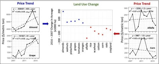
3.3.2. The Role of Crop Prices

Table 1 shows the crop price per unit area (in $ US per hectare), obtained by multiplying 10-year average crop yield (metric ton per hectare) with crop price per unit weight ($ US per metric ton). We find the prices of fruit/nut crops per hectare to be much higher than field crops. While the prices of tree nuts and fruit crops were estimated to be between $8000 and $25,000 per hectare (Table 1), the field crops were estimated to be much less between $800 to $5000 per hectare. Such high market profits from producing fruits/nuts is likely the primary motivation for the shift to tree nuts and fruit crops.
Figure 4m–r and Figure 5m–r displays the time series of crop prices (in $ US per metric ton) for each crop. During the 2007–2016 period, the prices of nuts and fruits were rising, whereas the prices of cereals were falling and the prices of alfalfa did not change significantly. Therefore, in addition to their higher prices, their increasing price trends have made nuts and fruits lucrative cash crops to grow.
The increasing price trend for tree nuts and fruit crops was largely driven by increased global demand (often surpassing global supply), as most of these crops were exported worldwide, primarily to European Union, Canada, China, Japan, and Mexico [45]. In addition, California dominates the supply sector, accounting for 90% of the world’s almond production, 75% of the world’s walnut production, and 25% of the world’s pistachio production.
The primary markets for alfalfa and cereals were domestic, and a number of factors were at play determining the domestic crop prices, including competition from other agricultural regions in the U.S. The alfalfa hay and silage corn prices were affected by losses in the dairy sector [46]. Reduced alfalfa production within Central Valley had already prompted expansion in other western States [47]. The prices for rice, corn, and grains have been declining for a number for years [48].
Cotton is an exception for which its acreage trend cannot be explained by price trend: its price showed an increasing trend yet its acreage was decreasing (Figure 5). Its relatively lower price ($4300 per hectare), growing pest problems [49], and high operational cost [50] have made cotton less attractive, especially when compared to high-value cash crops. The reduction of cotton acreage in Central Valley had been going on for several years including periods before the current study period. There was a decreasing trend in cotton acreage since the mid-1990s [49], as well as a staggering loss of 75% in cotton acreage from 1997 to 2008 [50].
To investigate the role of water extraction (pumping) cost in crop choice decisions, we present the change in groundwater head derived from groundwater well observations across Central Valley during drought 1 (Figure 8a) and drought 2 (Figure 8b). During drought 1 (moderate drought), 75% of the wells showed head depletion over 4 m, whereas, during drought 2 (severe drought), 75% of the wells showed more severe head depletion over 9 m. The groundwater depletion rate increased as one goes from north to south direction, with severe groundwater withdrawal (more than 30 m) in the southern region. In addition, shown in Figure 8 are the time series of groundwater depth obtained at three selected wells, located along a north-south transect in Central Valley. The water table drop between 2007 and 2016 varied from 5 m (in Sacramento county), to 13 m (in San Joaquin county), and to 37 m (in Tulare county), confirming that the groundwater depletion is severe in the southern region, which was characterized by large crop acreage changes. The high drawdown occurred due to intensive pumping during the drought events when surface water availability for irrigation was scarce. The pumping cost during the drought period increased by around $1000/year, on average, for Central Valley, and by a much higher amount in San Joaquin Valley [17]. Such a drawdown level in the southern part of Central valley incurred increasing pumping costs. Farmers in the southern part of Central Valley were, therefore, more likely to choose crop types that justify the additional water pumping cost. This seemed to favor the expansion of more profitable crops, mainly tree nuts and fruits, in which crop prices are increasingly high, compared to alfalfa, cereals, and cotton. Particularly, high water demand by alfalfa combined by its low value was unlikely to be a good crop choice during drought.

3.3.3. Impact on Water Resources

Table 2 shows the cropland water use (for each county and total) calculated by summing up the water used for each crop, which in turn was obtained from the product of the crop acreage and average crop water use. During the 2007–2016 period, the total crop water use remained about the same, despite the reduction in cropland area by 57,000 ha (or 2.6%). This can be explained by the cropping pattern shift from annual crops to more profitable perennial crops. Perennial crops, like almond and walnut trees, use more water per hectare—less than rice, but more than any of the other crops, especially cereals. During the 2007–2016 period, the field crops lost a total crop acreage of 543,000 ha, which translates to water reduction of 357,000 ha-m, or 658 mm of water per hectare, whereas tree nuts and field crops gained a total crop acreage of 485,000 ha, which translates to increased water use by 359,000 ha-m, or 739 mm of water per hectare. The water saved due to a reduction in cropland acreage was, therefore, compensated by cropping pattern shift to nuts and fruits, resulting in a similar level of total crop water use every year.
Although the total crop water use remained the same, the shift from annual (cereals and cotton) to perennial (nuts and fruits) had important implications on water resources. Perennial crops require watering throughout the year, whereas annual crops use water only during their growing season. In addition, the expansion of perennial crops—which need to be watered every year—lowers flexibility to reduce water use during drought years, unlike annual crops that can be fallowed or rotated as needed on a yearly basis. For example, during the 2012–2016 drought, some farmers bought million-dollar drilling rigs to access deep groundwater aquifer, just to protect their massive investments in almond plantations [51].
At the county-level, the impact of crop acreage change on water use was highly variable, indicating that the importance of water use is highly context-specific. Among San Joaquin Valley counties, water use for Madera county increased by 25% (in 2016 compared to 2007), whereas water use for Kings county decreased by 26%. Madera was primarily characterized by large expansion of almonds (by 5000 ha) and grapes (by 16,000 ha), and modest reduction of alfalfa (by 13,000 ha). In contrast, Kings county was primarily characterized by large reductions of alfalfa (by 24,000 ha), cotton (21,000 ha), and corn (by 16,000 ha) and modest increases in tomato acreage (by 12,000 ha). Amongst Sacramento Valley counties, water use for Tehama increased by 54%, while it decreased for Shasta by 25%. Tehama saw large increases in almonds and walnuts (each increased by about 5000 ha), whereas Shasta saw its rice acreage (which was dominant in 2007) being completely wiped out in 2016. These water use changes can be integrated into water balances of the areas in order to further relate their impacts to the available surface and groundwater water resources.

4. Summary and Conclusions

This study has examined the agricultural land use changes in Central Valley, California, during 2007–2016, in response to two consecutive droughts (drought 1: 2007–2009, and drought 2: 2012–2016), and associated drivers and impacts on water resources. The analyses were performed both at Central Valley, as well as county levels.
At the Central Valley level, from 2007 to 2016, acreages of tree nuts (almonds, walnuts, and pistachios) grew by 371,000 ha ( +64%), and acreages of fruit crops (grapes, oranges, and tomatoes) grew by 217,000 ha ( +72%). On the other hand, alfalfa acreage reduced by 197,000 ha (−48%), cotton acreage reduced by 112,000 ha (−54%), and acreage of cereal crops (corn, winter wheat, oats) reduced by 338,813 ha (or −46%). Overall, the active cultivated land decreased by 57,000 ha (or −2.6%). The shift in this cropping pattern was likely driven by high crop prices, increasing trend in price trend, and increasing water pumping cost, particularly in the relatively water-stressed San Joaquin Valley. The total cropland water use remained the same during the 2007–2016 period (whether it was wet or dry year), despite a reduction in irrigated land acreage (by 57,000 ha or −2.6%), indicating that the water saved due to the reduced irrigated land was compensated by the cropping pattern shift. This practice resulted in substantial drawdown of groundwater during drought years, by up to 30 m in some southern parts of the Central valley. This is unsustainable and requires solutions (policy, management, and technology) to manage California’s agriculture and water resources.
At the county level, there are similarities, as well as differences, in results among counties. All counties showed a similar shift in cropping pattern. However, the magnitudes of the crop pattern changes were much larger in the southern Central Valley regions, where water resources are relatively more limited compared to the northern Central valley regions. In addition, the impact of crop acreage changes on total water use varied highly from county to county. From 2007 to 2016, some counties in San Joaquin Valley (e.g., Kings) showed substantial reductions in crop water use (by 30,000 ha-m, or −26%), while some other counties (e.g., Madera) showed an increase in crop water use (by 18,000 ha-m or +25%). Similarly, in Sacramento Valley, some counties (e.g., Shasta) showed large reductions in crop water use, while other counties (e.g., Tehama) showed substantial increases in crop water use. This indicates that water resource management issues vary from county to county; therefore, the solutions must be county-specific. The change in crop water use was affected by both the change in the size of irrigated land, as well as the change in the relative proportion of crop types, indicating that both land management (size of fallow land) and crop management (choice of crop types) are key factors in water resource management. In this regard, it is crucial to develop a long-term plan so that farmers know ahead of time how much water is available to them and so that farmers who need to reduce perennial crop acreages can do so without large investment losses. Given that farmer profit is the primary driver of crop type decisions, it should be considered in the development of effective water resource management strategies.
In addition to policy and management solutions, technological solutions may also be important; however, research is needed to evaluate the effectiveness of such solutions from the scientific community’s current understanding of the food-energy-water nexus framework, as opposed to the traditional water-centric approach [52,53]. For example, recently, the Alfalfa Project (https://thealfalfaproject.com/) was initiated to enable the conversion of 95,000 hectares of alfalfa in San Joaquin Valley from traditional flood (and, in some cases, sprinkler) irrigation to subsurface drip irrigation, with the expectation that this would reduce water usage by some 47%. However, there are concerns that such high-efficiency irrigation technologies will reduce the recharge to groundwater and, therefore, end up exacerbating the water severity problem in the region rather than solving it. For the Ogallala High-Plains Aquifer region, it was found that efficient irrigation technologies reduced groundwater recharge, as irrigated acreages substantially increased after the widespread introduction of efficient irrigation technologies [52]. Research is, therefore, needed in Central Valley to assess the impacts of high-efficiency irrigation technologies on groundwater level.
Another example of technological solution that is currently the priority of California Department of Water Resources is the Managed Aquifer Recharge (MAR). MAR methods capture excess winter streamflow from rivers/creeks to recharge groundwater for later use. MAR projects already exist in few locations of southern Central Valley (e.g., Kern Water Bank). However, the capacity of MAR to recover southern Central Valley’s existing groundwater overdraft is limited without transferring water from the delta [54]. MAR can only recover around 3% to 8% of existing groundwater overdraft in San Joaquin Valley using excess flow in this region [54]. This indicates the limitation of the supply side to halt groundwater problem and the necessity of managing the demand side (e.g., land and crop management).
Sustainable water resource management should also consider other competing water demands, such as urban and ecological needs, and emerging soil salinity issues in irrigated agriculture [55,56]. Finally, we note that the findings of this study are based on acreage data from the Landsat-based CDL products and are valid to the extent that the accuracy of these products (mainly their trends) are realistic.

Author Contributions

Conceptualization: L.T.G.; methodology; P.K.K., L.T.G.; software: P.K.K.; formal analysis: M.G. and P.K.K.; writing—original draft, M.G. and P.K.K.; writing—review and editing—M.G., L.T.G., P.K.K., S.A.; visualization—S.A.; supervision—M.G., L.T.G.; funding acquisition—M.G. All authors have read and agreed to the published version of the manuscript.

Funding

We acknowledge funding support from the University of California Research Initiatives Award through grant # LFR-18-548316 and from Syngenta Crop Protection LLC through grant # TK0251998.

Data Availability Statement

We acknowledge USDA National Agricultural Statistics Service Information (NASS) for providing public access to the crop price and crop yield data (https://quickstats.nass.usda.gov/), and cropland data layer (https://nassgeodata.gmu.edu/CropScape/) that were used in this study.

Conflicts of Interest

The authors declare no conflict of interest.

References

  1. Diffenbaugh, N.S.; Swain, D.L.; Touma, D. Anthropogenic warming has increased drought risk in California. Proc. Natl. Acad. Sci. USA 2015, 112, 3931–3936. [Google Scholar] [CrossRef] [Green Version]
  2. Wegren, S.K. Food security and Russia’s 2010 drought. Eurasian Geogr. Econ. 2011, 52, 140–156. [Google Scholar] [CrossRef]
  3. De Châtel, F. The role of drought and climate change in the Syrian uprising: Untangling the triggers of the revolution. Middle East. Stud. 2014, 50, 521–535. [Google Scholar] [CrossRef]
  4. Maxwell, D.; Fitzpatrick, M. The 2011 Somalia famine: Context, causes, and complications. Glob. Food Secur. 2012, 1, 5–12. [Google Scholar] [CrossRef]
  5. Mallya, G.; Zhao, L.; Song, X.C.; Niyogi, D.; Govindaraju, R.S. 2012 Midwest drought in the United States. J. Hydrol. Eng. 2013, 18, 737–745. [Google Scholar] [CrossRef]
  6. Wang, S.; Yuan, X.; Li, Y. Does a strong El Niño imply a higher predictability of extreme drought? Sci. Rep. 2017, 7, 40741. [Google Scholar] [CrossRef] [PubMed] [Green Version]
  7. Solander, K.C.; Wilson, C.J. The Cape Town Drought: What is Happening and Will It Happen Again? (No. LA-UR-18-21239); Los Alamos National Lab. (LANL): Los Alamos, NM, USA, 2018. [Google Scholar]
  8. Medellín-Azuara, J.; MacEwan, D.; Howitt, R.E.; Sumner, D.A.; Lund, J.R.; Scheer, J.; Gailey, R.; Hart, Q.; Alexander, N.D.; Arnold, B.; et al. Economic Analysis of the 2016. California Drought on Agriculture; Center for Watershed Sciences: Davis, CA, USA, 2016. [Google Scholar]
  9. Griffin, D.; Anchukaitis, K.J. How unusual is the 2012–2014 California drought? Geophys. Res. Lett. 2014, 41, 9017–9023. [Google Scholar] [CrossRef] [Green Version]
  10. Belmecheri, S.; Babst, F.; Wahl, E.R.; Stahle, D.W.; Trouet, V. Multi-century evaluation of Sierra Nevada snowpack. Nat. Clim. Chang. 2016, 6, 2–3. [Google Scholar] [CrossRef]
  11. Swain, D.L.; Tsiang, M.; Haugen, M.; Singh, D.; Charland, A.; Rajaratnam, B.; Diffenbaugh, N.S. The extraordinary California drought of 2013/2014: Character, context, and the role of climate change. Bull. Am. Meteorol. Soc. 2014, 95, S3–S7. [Google Scholar]
  12. USDM. US Drought Monitor. 2018. Available online: https://droughtmonitor.unl.edu/ (accessed on 10 February 2021).
  13. Reilly, T.E. Ground-Water Availability in the United States; U.S. Geological Survey Circular 1323: Denver, CO, USA, 2008; p. 84. ISBN 978-1-4113-2183-0. [Google Scholar]
  14. Faunt, C.C. (Ed.) Groundwater Availability of the Central Valley Aquifer, California; U.S. Geological Survey Professional Paper 1766: Denver, CO, USA, 2009; p. 173. [Google Scholar]
  15. Hanak, E.; Escriva-Bou, A.; Gray, B.; Green, S.; Harter, T.; Jezdimirovic, J.; Lund, J.; Medellin-Azuara, J.; Moyle, P.; Seavy, N. Water and the Future of the San Joaquin Valley. 2019. Available online: https://www.ppic.org/publication/water-and-the-future-of-the-san-joaquin-valley/ (accessed on 30 June 2020).
  16. Cooley, H.; Donnelly, K.; Phurisamban, R.; Subramanian, M. Impacts of California’s ongoing Drought: Agriculture; Pacific Institute: Oakland, CA, USA, 2015; p. 24. [Google Scholar]
  17. Medellin-Azuara, J.; MacEwan, D.; Howitt, R.E.; Koruakos, G.; Dogrul, E.C.; Brush, C.F.; Kadir, T.N.; Harter, T.; Melton, F.; Lund, J.R. Hydro-economic analysis of groundwater pumping for irrigated agriculture in California’s Central Valley, USA. Hydrogeol. J. 2015, 23, 1205–1216. [Google Scholar] [CrossRef]
  18. Christian-Smith, J.; Levy, M.C.; Gleick, P.H. Impacts of the California Drought from 2007 to 2009; Pacific Institute: Oakland, CA, USA, 2011; p. 105. [Google Scholar]
  19. Schauer, M.; Senay, G.B. Characterizing Crop Water Use Dynamics in the Central Valley of California Using Landsat-Derived Evapotranspiration. Remote Sens. 2019, 11, 1782. [Google Scholar] [CrossRef] [Green Version]
  20. Mall, N.K.; Herman, J.D. Water shortages risks from perennial crop expansion in California’s Central Valley. Environ. Res. Lett. 2019, 14, 1–9. [Google Scholar] [CrossRef]
  21. Johnson, R.; Cody, B.A. California Agricultural Production and Irrigated Water Use; Congressional Research Service: Washington, DC, USA, 2015. [Google Scholar]
  22. Goldhamer, D.A.; Fereres, E. Establishing an almond water production function for California using long-term yield response to variable irrigation. Irrig. Sci. 2017, 35, 169–179. [Google Scholar] [CrossRef]
  23. Fulton, J.; Norton, M.; Shilling, F. Water-indexed benefits and impacts of California almonds. Ecol. Indic. 2018, 96. [Google Scholar] [CrossRef]
  24. Kang, M.; Ayars, J.E.; Jackson, R.B. Deep groundwater quality in the southwestern United States. Environ. Res. Lett. 2019, 14, 034004. [Google Scholar] [CrossRef] [Green Version]
  25. Konikow, L.F.; Kendy, E. Groundwater depletion: A global problem. Hydrogeol. J. 2005, 13, 317–320. [Google Scholar] [CrossRef]
  26. Jeanne, P.; Farr, T.G.; Rutqvist, J.; Vasco, D.W. Role of agricultural activity on land subsidence in the San Joaquin Valley, California. J. Hydrol. 2019, 569, 462–469. [Google Scholar] [CrossRef] [Green Version]
  27. Alam, S.; Gebremichael, M.; Li, R.; Dozier, J.; Lettenmaier, D.P. Climate change impacts on groundwater storage in the Central Valley, California. Clim. Chang. 2019, 157, 387–406. [Google Scholar]
  28. Barnett, T.; Pierce, D.W. Sustainable water deliveries from the Colorado River in a changing climate. Proc. Natl. Acad. Sci. USA 2009, 106, 7334–7338. [Google Scholar] [CrossRef] [Green Version]
  29. Cayan, D.R.; Das, T.; Pierce, D.W.; Barnett, T.P.; Tyree, M.; Gershunov, A. Future dryness in the southwest US and the hydrology of the early 21st century drought. Proc. Natl. Acad. Sci. USA 2010, 107, 21271–21276. [Google Scholar] [CrossRef] [Green Version]
  30. Lo, M.H.; Famiglietti, J.S. Irrigation in California’s Central Valley strengthens the southwestern US water cycle. Geophys. Res. Lett. 2013, 40, 301–306. [Google Scholar] [CrossRef] [Green Version]
  31. Conrad, E.; Moran, T.; DuPraw, M.E.; Ceppos, D.; Martinez, J.; Blomquist, W. Diverse stakeholders create collaborative, multilevel basin governance for groundwater sustainability. Calif. Agric. 2018, 72, 44–53. [Google Scholar] [CrossRef]
  32. Lund, J.R.; Medellin-Azuara, J.; Durand, J.; Stone, K. Lessons from California’s 2012–2016 drought. J. Water Resour. Plan. Manag. 2018, 144. [Google Scholar] [CrossRef] [Green Version]
  33. Scanlon, B.R.; Faunt, C.C.; Longuevergne, L.; Reedy, R.C.; Alley, W.M.; McGuire, V.L.; McMahon, P.B. Groundwater depletion and sustainability of irrigation in the US High Plains and Central Valley. Proc. Natl. Acad. Sci. USA 2012, 109, 9320–9325. [Google Scholar] [CrossRef] [Green Version]
  34. National Academy of Sciences. Assessing Risks to Endangered and Threatened Species for Pesticides; National Academic Press: Washington, DC, USA, 2013. [Google Scholar]
  35. USDA. National Agricultural Statistics Service. QuickStats Dataset. 2017. Available online: https://quickstats.nass.usda.gov/ (accessed on 10 February 2021).
  36. Johnson, D.M.; Mueller, R. The 2009 Cropland Data Layer. Photogramm. Eng. Remote Sens. 2010, 76, 1201–1205. [Google Scholar]
  37. Fisher, R.A. On the probable error of a coefficient of correlation deduced from a small sample. Metron 1921, 1, 3–32. [Google Scholar]
  38. Kendall, M.G. Rank Correlation Methods, 4th ed.; Charles Griffin: London, UK, 1975. [Google Scholar]
  39. Khambhammettu, P. Mann-Kendall Analysis for the Fort Ord Site; OU-1 2004 Annual Groundwater Monitoring Report—Former Fort Ord, California; HydroGeoLogic, Inc.: Reston, VA, USA, 2005. [Google Scholar]
  40. Carlisle, E.A.; Steenwerth, K.L.; Smart, D.R. Effects of land use on soil respiration: Conversion of oak woodlands to vineyards. J. Environ. Qual. 2006, 35, 1396–1404. [Google Scholar] [CrossRef] [PubMed] [Green Version]
  41. Soulard, C.E.; Wilson, T.S. Recent land-use/land-cover change in the Central California Valley. J. Land Use Sci. 2015, 10, 59–80. [Google Scholar]
  42. Lobell, D.B.; Field, C.B. Historical effects of temperature and precipitation on California crop yields. Clim. Chang. 2007, 81, 187–203. [Google Scholar] [CrossRef]
  43. Boriss, H.; Brunke, H. Commodity Profile: Almonds; University of California: Oakland, CA, USA, 2005. [Google Scholar]
  44. Hopes Widespread for ‘Normal’ California Pistachio Crop. Available online: https://www.farmprogress.com/tree-nuts/hopes-widespread-normal-california-pistachio-crop (accessed on 4 December 2020).
  45. California Agricultural Statistics Review. 2017. Available online: https://www.cdfa.ca.gov/statistics/PDFs/2017-18AgReport.pdf (accessed on 10 September 2010).
  46. Matthews, W.A.; Sumner, D.A. Contributions of the California Dairy Industry to the California Economy in 2018. A Report to the California Milk Advisory Board; University of California, Agricultural Issues Center: Oakland, CA, USA, 2019. [Google Scholar]
  47. Dumas, C. Landscape Shifting for Export Hay, Analyst Says; Capital Press: Salem, OR, USA, 2018. [Google Scholar]
  48. Medellin-Azuara, J.; Howitt, J.R.; MacEwan, D.; Lund, J. Economic impacts of climate-related changes to California agriculture. Clim. Chang. 2011, 109, S387–S405. [Google Scholar] [CrossRef]
  49. Geisseler, D.; Horwath, W.R. Cotton Production in California. Assessment of Plant Fertility and Fertilizer Requirements for Agricultural Crops in California. 2013. Available online: http://apps.cdfa.ca.gov/frep/docs/Cotton_Production_CA.pdf (accessed on 12 July 2020).
  50. Farmprogress. Central Valley: Permanent Crops, Dairy Increase; Major Cotton Reduction. 2019. Available online: https://www.farmprogress.com/central-valley-permanent-crops-dairy-increase-major-cotton-reduction (accessed on 13 July 2020).
  51. Holthaus, E. The Thirsty West: 10 Percent of California’s Water Goes to Almond Farming. Slate. 2014. Available online: http://www.slate.com/articles/technology/future_tense/2014/05/_10_percent_of_california_s_water_goes_to_almond_farming.html (accessed on 9 February 2021).
  52. Smidt, S.J.; Haacker, E.M.; Kendall, A.D.; Deines, J.M.; Pei, L.; Cotterman, K.A.; Li, H.; Liu, X.; Basso, B.; Hyndman, D.W. Complex water management in modern agriculture: Trends in the water-energy-food nexus over the High Plains Aquifer. Sci. Total Environ. 2016, 566, 988–1001. [Google Scholar] [CrossRef] [PubMed] [Green Version]
  53. Alam, S.; Gebremichal, M.; Li, R. Remote Sensing-Based Assessment of the Crop, Energy and Water Nexus in the Central Valley, California. Remote Sens. 2019, 11, 1701. [Google Scholar] [CrossRef] [Green Version]
  54. Alam, S.; Gebremichal, M.; Li, R.; Dozier, J.; Lettenmaier, D.P. Can Managed Aquifer Recharge Mitigate the Groundwater Overdraft in California’s Central Valley? Water Resour. Res. 2020, 56. [Google Scholar] [CrossRef]
  55. Schoups, G.; Hopmans, J.W.; Young, C.A.; Vrugt, J.A.; Wallender, W.W.; Tanji, K.K.; Panday, S. Sustainability of irrigated agriculture in the San Joaquin Valley, California. Proc. Natl. Acad. Sci. USA 2005, 102, 15352–15356. [Google Scholar] [CrossRef] [PubMed] [Green Version]
  56. Letey, J. Soil salinity poses challenges for sustainable agriculture and wildlife. Calif. Agric. 2000, 54, 43–48. [Google Scholar] [CrossRef]
Figure 1. Percent of total area affected by drought in the State of California, United States [12].
Remotesensing 13 00650 g001
Figure 2. Study area map and long-term rainfall: (a) location of the Central Valley in the U.S.; (b) Central Valley location in California, (c) counties of the Central valley and its sub-basins (San Joaquin valley, and Sacramento valley), and (d) long-term (2000–2018) mean annual rainfall (mm/year) obtained from the WorldClim global climate dataset (http://worldclim.org/).
Remotesensing 13 00650 g002
Figure 3. Time series of (a) active cropland, (b) fallow cropland, and (c) pasture land and forest land, for Central Valley, and its two sub-basins, Sacramento Valley and San Joaquin Valley. In addition, shown are fitted linear equations (in dotted lines), coefficient of determinations (R2), and Mann-Kendall trend test p values. p-values (PMK) less than 0.1 indicate trend is statistically significant at 10% significance level.
Remotesensing 13 00650 g003
Figure 4. Time series of crop acreage, yield, and price for the most six dominant crops in Central Valley: (af) crop acreage (× 1000 hectare), (gl) crop yield (metric ton/hectare), and (mr) crop price (US $/metric ton). In addition, shown are fitted linear equations (in dotted lines), coefficient of determinations (R2), and Mann-Kendall trend test p values. p-values (PMK) less than 0.1 indicate trend is statistically significant at 10% significance level.
Remotesensing 13 00650 g004
Figure 5. A continuation of Figure 4 for the remaining dominant crops.
Remotesensing 13 00650 g005
Figure 6. The change in crop acreage (in hectares) in Central Valley between 2016 and 2007 for each crop type, and the total cropland. The change is calculated as the acreage in 2016 minus the acreage in 2007.
Remotesensing 13 00650 g006
Figure 7. The change in crop acreage (in hectares) in each of the Central Valley counties between 2016 and 2007 for each crop type, and the total cropland.
Remotesensing 13 00650 g007
Figure 8. The groundwater head change during (a) drought 1 and (b) drought 2, and (c) time series of depth to groundwater for three wells located in Sacramento county, San Joaquin county, and Tulare county.
Remotesensing 13 00650 g008
Table 1. The 10-year (2007–2016) average crop yield (metric ton per hectare), crop price ($ US per metric ton), crop price ($ US per hectare), and crop price ($ US per hectare-m), for each crop type. The crop prices are adjusted for inflation.
Crop TypeAnnual Crop Yield
(Metric Ton Per Hectare)
Crop Price
($ US Per Metric Ton)
Crop Price
($ US Per Hectare)
Crop Price
($ US Per Hectare-m)
Perennial Crops
Almonds (utilized, shelled)2.45561013,74515,983
Walnuts4.20281111,80613,889
Pistachios3.15563217,74137,747
Grapes (fresh market)18.14143125,95850,898
Oranges29.30297870213,185
Annual Crops
Alfalfa15.5621833924463
Cotton1.65261743186643
Rice9.4641839543766
Winter Wheat5.4122612233058
Corn11.3521524403813
Oats3.132628201491
Tomatoes (processing)103.49710,03012,696
Table 2. Impact on cropland water use estimates. Columns 2 and 3: cropland water use estimates (in ha-m) for years 2007 and 2016; columns 3 and 4: difference in cropland water use estimates between the two years (ha-m), and as a percentage of the 2007 cropland water use. The cropland water use was estimated by summing up the water use for each crop, which in turn was calculated by multiplying the crop-specific acreage with the mean crop-specific water use provided in Reference [19].
County2007 Water Use2016 Water Use2016–2007 Change in Water Use
(ha-m)(ha-m)(ha-m)(%)
Shasta36251748−1877−52
Tehama11,54617,735618954
Glenn74,07077,84437745
Butte67,61379,75112,13818
Colusa101,12499,849−1275−1
Sutter78,96379,4695061
Yuba26,13726,2431060
Yolo70,46870,127−3410
Placer11,3147633−3681−33
Sacramento30,97427,861−3112−10
Merced132,687121,212−11,475−9
San Joaquin132,275132,6653890
Stanislaus82,34889,03366858
Fresno243,690249,65659652
Madera72,97891,10818,13025
Kern194,461184,275−10,186−5
Kings117,49287,152−30,339−26
Tulare148,375158,46810,0927
TOTAL1,600,1411,601,82916880.11
Publisher’s Note: MDPI stays neutral with regard to jurisdictional claims in published maps and institutional affiliations.

