
Lightning under Different Land Use and Cover, and the Influence of Topography in the Carajás Mineral Province, Eastern Amazon
 ,
,  , ,
, ,  ,
, 
Abstract
:1. Introduction
2. Materials and Methods
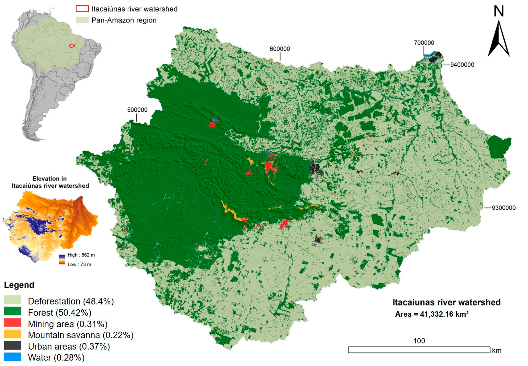
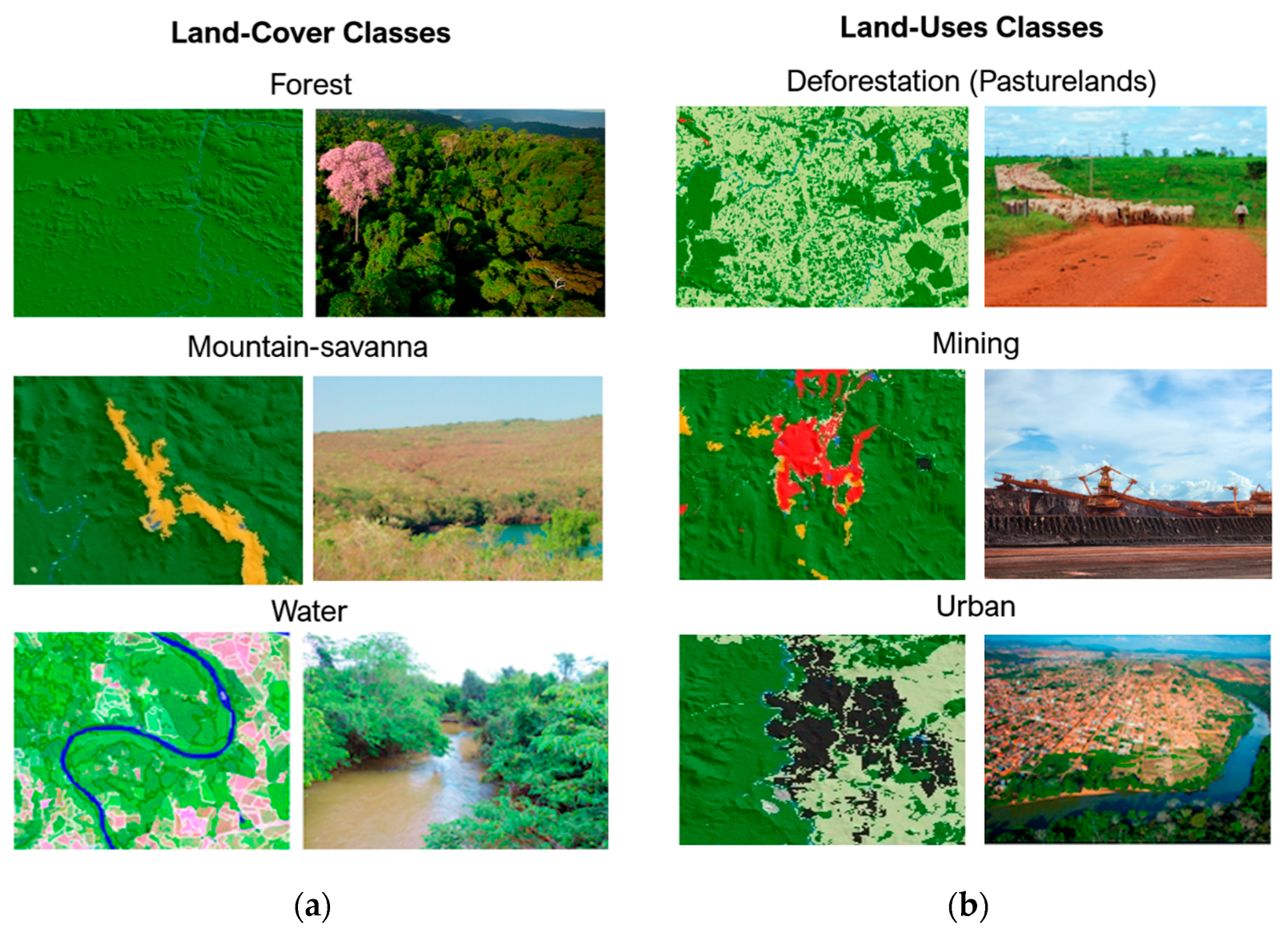
2.1. Study Area
2.2. Data
2.3. Methodology
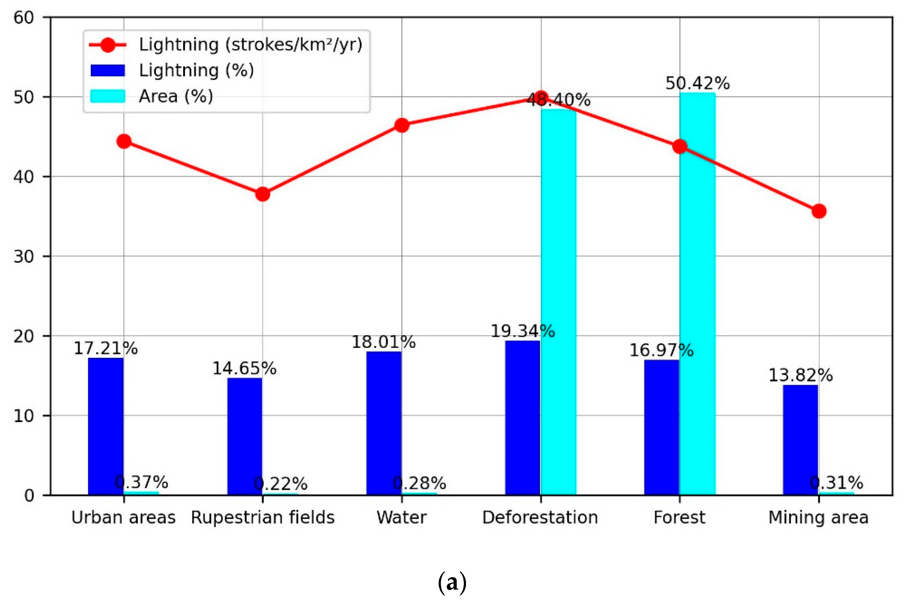
3. Results
4. Conclusions
Author Contributions
Funding
Institutional Review Board Statement
Informed Consent Statement
Data Availability Statement
Acknowledgments
Conflicts of Interest
References
- Santos, A.P.P.; Coelho, C.A.; Pinto Junior, O.; dos Santos, S.R.Q.; de Lima, F.J.L.; De Souza, E.B. Climatic diagnostics associated with anomalous lightning incidence during the summer 2012/2013 in Southeast Brazil. Int. J. Climatol. 2018, 38, 996–1009. [Google Scholar] [CrossRef]
- IPCC. 2022: Climate Change 2022: Impacts, Adaptation and Vulnerability. Contribution of Working Group II to the Sixth Assessment Report of the Intergovernmental Panel on Climate Change; Pörtner, H.-O., Roberts, D.C., Tignor, M., Poloczanska, E.S., Mintenbeck, K., Alegría, A., Craig, M., Langsdorf, S., Löschke, S., Möller, V., et al., Eds.; Cambridge University Press: Cambridge, UK; New York, NY, USA, 2022; p. 3056. [Google Scholar] [CrossRef]
- Shukla, P.R.; Skeg, J.; Buendia, E.C.; Masson-Delmotte, V.; Pörtner, H.-O.; Roberts, D.C.; Zhai, P.; Slade, R.; Connors, S.; van Diemen, S.; et al. Climate Change and Land: An IPCC Special Report on Climate Change, Desertification, Land Degradation, Sustainable Land Management, Food Security, and Greenhouse Gas Fluxes in Terrestrial Ecosystems; 2019. Available online: https://philpapers.org/rec/SHUCCA-2 (accessed on 14 March 2024).
- Souza-Filho, P.W.M.; de Souza, E.B.; Júnior, R.O.S.; Nascimento, W.R., Jr.; de Mendonça, B.R.V.; Guimarães, J.T.F.; Dall’Agnol, R.; Siqueira, J.O. Four decades of land-cover, land-use and hydroclimatology changes in the Itacaiúnas River watershed, southeastern Amazon. J. Environ. Manag. 2016, 167, 175–184. [Google Scholar] [CrossRef] [PubMed]
- Kumar, M.; Denis, D.M.; Kundu, A.; Joshi, N.; Suryavanshi, S. Understanding land use/land cover and climate change impacts on hydrological components of Usri watershed, India. Appl. Water Sci. 2022, 12, 39. [Google Scholar] [CrossRef]
- Chilukoti, N.; Xue, Y. An assessment of potential climate impact during 1948–2010 using historical land use land cover change maps. Int. J. Clim. 2020, 41, 295–315. [Google Scholar] [CrossRef]
- Kar, S.K.; Liou, Y.-A. Influence of land use and land cover change on the formation of local lightning. Remote Sens. 2019, 11, 407. [Google Scholar] [CrossRef]
- Sokol, N.J.; Rohli, R.V. Land cover, lightning frequency, and turbulent fluxes over Southern Louisiana. Appl. Geogr. 2018, 90, 1–8. [Google Scholar] [CrossRef]
- Pinto, O., Jr.; de Almeida Pinto, I.R.C.; Neto, O.P. Lightning enhancement in the Amazon region due to urban activity. Am. J. Clim. Change 2013, 2, 270–274. [Google Scholar] [CrossRef]
- Naccarato, K.P.; Pinto, O., Jr.; Pinto, I.R.C.D.A. Evidence of thermal and aerosol effects on the cloud-to-ground lightning density and polarity over large urban areas of Southeastern Brazil. Geophys. Res. Lett. 2003, 30. [Google Scholar] [CrossRef]
- Farias, W.R.G.; Pinto, O., Jr.; Naccarato, K.P.; Pinto, I.R.C.A. Anomalous lightning activity over the Metropolitan Region of São Paulo due to urban effects. Atmos. Res. 2009, 91, 485–490. [Google Scholar] [CrossRef]
- Bourscheidt, V.; Pinto, O.; Naccarato, K.; Pinto, I. The influence of topography on the cloud-to-ground lightning density in South Brazil. Atmos. Res. 2009, 91, 508–513. [Google Scholar] [CrossRef]
- Cummins, K.L. Mapping the impact of terrain on lightning incidence and multiple ground contacts in cloud-to-ground flashes. In Proceedings of the XV International Conference on Atmospheric Electricity, Norman, Oklahoma, USA, 15–20 June 2014. [Google Scholar]
- Souza-Filho, P.W.M.; de Lucia Lobo, F.; Cavalcante, R.B.L.; Mota, J.A.; da Rocha Nascimento, W., Jr.; Santos, D.C.; Siqueira, J.O. Land-use intensity of official mineral extraction in the Amazon region: Linking economic and spatial data. Land Degrad. Dev. 2021, 32, 1706–1717. [Google Scholar] [CrossRef]
- Silva, M.S.D.; Cavalcante, R.L.; Souza Filho, P.W.M.; Silva Júnior, R.O.D.; Pontes, P.R.; Dallagnol, R.; Rocha, E.J.P.D. Comparison of sediment rating curves and sediment yield in subbasins of the Itacaiúnas River Watershed, Eastern Amazon. RBRH 2021, 26, e18. [Google Scholar] [CrossRef]
- Instituto Brasileiro de Geografia e Estatística (IBGE). Available online: https://censoagro2017.ibge.gov.br/ (accessed on 22 January 2023).
- Silva Júnior, R.O.; Queiroz, J.C.B.; Ferreira, D.B.S.; Tavares, A.L.; Souza-Filho, P.W.M.; Guimarães, J.T.F.; Rocha, E.J.P. Estimativa de precipitação e vazões médias para a bacia hidrográfica do rio Itacaiúnas (BHRI), Amazônia Oriental, Brasil. RBGF 2017, 10, 1638–1654. [Google Scholar] [CrossRef]
- Elat/Inpe. Available online: http://www.inpe.br/webelat/homepage/ (accessed on 12 January 2022).
- Pinto, J.R.O. A Arte da Guerra Contra os Raios; Oficina de Textos: São Paulo, Brazil, 2005. [Google Scholar]
- Pinto, J.R.O. Lightning in the Tropics; Nova Publishers: New York, NY, USA, 2009. [Google Scholar]
- Goodman, S.J.; Blakeslee, R.J.; Koshak, W.J.; Mach, D.; Bailey, J.; Buechler, D.; Carey, L.; Schultz, C.; Bateman, M.; McCaul, E.; et al. The GOES-R geostationary lightning mapper (GLM). Atmos. Res. 2013, 125–126, 34–49. [Google Scholar] [CrossRef]
- Murphy, M.J.; Ryan, K.S. Comparisons of lightning rates and properties from the US National Lightning Detection Network (NLDN) and GLD360 with GOES-16 Geostationary Lightning Mapper and Advanced Baseline Imager data. Geophys. Res. Atmos. 2020, 125, e2019JD031172. [Google Scholar] [CrossRef]
- Pinto, J.R.O.; Pinto, I.R.C.A. A new Lightning Location System. In Proceedings of the International Conference on Lightning Physics and Effects, Florida, USA, 12–15 March 2018. [Google Scholar]
- Souza-Filho, P.W.M.; Nascimento, W.R., Jr.; Santos, D.C.; Weber, E.J.; Silva, R.O., Jr.; Siqueira, J.O. A GEOBIA approach for multitemporal land-cover and land-use change analysis in a tropical watershed in the southeastern Amazon. Remote Sens. 2018, 10, 1683. [Google Scholar] [CrossRef]
- Topodata. Available online: http://www.dsr.inpe.br/topodata/ (accessed on 23 March 2022).
- Kim, J.; Scott, C.D. Robust kernel density estimation. J. Mach. Learn. Res. 2012, 13, 2529–2565. [Google Scholar]
- Elat/Inpe. Lightning fatalities in Brazil. Available online: http://www.inpe.br/webelat/imagesNovoLayout/arte/Infografico_Mortes_Raios_2000-2019_alta.jpg (accessed on 8 July 2023).
- Censo. Available online: https://censo2022.ibge.gov.br/ (accessed on 24 June 2023).
- Wallace, J.M.; Hobbs, P.V. Atmospheric Science: An Introductory Survey; Elsevier: Amsterdam, The Netherlands, 2006; Volume 92. [Google Scholar]
- Heidler, F.; Cvetic, J.; Stanic, B. Calculation of lightning current parameters. IEEE Trans. Power Deliv. 1999, 14, 399–404. [Google Scholar] [CrossRef]
- Liu, Y.; Guha, A.; Said, R.; Williams, E.; Lapierre, J.; Stock, M.; Heckman, S. Aerosol effects on lightning characteristics: A comparison of polluted and clean regimes. Geophys. Res. Lett. 2020, 47, e2019GL086825. [Google Scholar] [CrossRef]
- Zhao, P.; Li, Z.; Xiao, H.; Wu, F.; Zheng, Y.; Cribb, M.C.; Jin, X.; Zhou, Y. Distinct aerosol effects on cloud-to-ground lightning in the plateau and basin regions of Sichuan, Southwest China. Atmos. Chem. Phys. 2020, 20, 13379–13397. [Google Scholar] [CrossRef]
- de Abreu, L.P.; Gonçalves, W.A.; Mattos, E.V.; Albrecht, R.I. Assessment of the total lightning flash rate density (FRD) in northeast Brazil (NEB) based on TRMM orbital data from 1998 to 2013. Int. J. Appl. Earth Obs. Geoinf. 2020, 93, 102195. [Google Scholar] [CrossRef]


Disclaimer/Publisher’s Note: The statements, opinions and data contained in all publications are solely those of the individual author(s) and contributor(s) and not of MDPI and/or the editor(s). MDPI and/or the editor(s) disclaim responsibility for any injury to people or property resulting from any ideas, methods, instructions or products referred to in the content. |
© 2024 by the authors. Licensee MDPI, Basel, Switzerland. This article is an open access article distributed under the terms and conditions of the Creative Commons Attribution (CC BY) license (https://creativecommons.org/licenses/by/4.0/).
Share and Cite
Santos, A.P.P.d.; Ferreira, D.B.d.S.; Nascimento Júnior, W.d.R.; Souza-Filho, P.W.M.e.; Pinto Júnior, O.; Lima, F.J.L.d.; Bourscheidt, V.; Mattos, E.V.; Costa, C.P.W.d.; Nogueira Neto, A.V.; et al. Lightning under Different Land Use and Cover, and the Influence of Topography in the Carajás Mineral Province, Eastern Amazon. Atmosphere 2024, 15, 375. https://doi.org/10.3390/atmos15030375
Santos APPd, Ferreira DBdS, Nascimento Júnior WdR, Souza-Filho PWMe, Pinto Júnior O, Lima FJLd, Bourscheidt V, Mattos EV, Costa CPWd, Nogueira Neto AV, et al. Lightning under Different Land Use and Cover, and the Influence of Topography in the Carajás Mineral Province, Eastern Amazon. Atmosphere. 2024; 15(3):375. https://doi.org/10.3390/atmos15030375
Chicago/Turabian StyleSantos, Ana Paula Paes dos, Douglas Batista da Silva Ferreira, Wilson da Rocha Nascimento Júnior, Pedro Walfir Martins e Souza-Filho, Osmar Pinto Júnior, Francisco José Lopes de Lima, Vandoir Bourscheidt, Enrique Vieira Mattos, Claudia Priscila Wanzeler da Costa, Antônio Vasconcelos Nogueira Neto, and et al. 2024. "Lightning under Different Land Use and Cover, and the Influence of Topography in the Carajás Mineral Province, Eastern Amazon" Atmosphere 15, no. 3: 375. https://doi.org/10.3390/atmos15030375