Perspective

Unmanned Aerial Systems for Monitoring Trace Tropospheric Gases

by
Travis J. Schuyler
and
Marcelo I. Guzman
*
Department of Chemistry, University of Kentucky, Lexington, KY 40506, USA
*
Author to whom correspondence should be addressed.
Atmosphere 2017, 8(10), 206; https://doi.org/10.3390/atmos8100206
Submission received: 6 October 2017 / Revised: 6 October 2017 / Accepted: 21 October 2017 / Published: 23 October 2017
(This article belongs to the Special Issue Atmospheric Measurements with Unmanned Aerial Systems (UAS))

Abstract

:
The emission of greenhouse gases (GHGs) has changed the composition of the atmosphere during the Anthropocene. Accurately documenting the sources and magnitude of GHGs emission is an important undertaking for discriminating the contributions of different processes to radiative forcing. Currently there is no mobile platform that is able to quantify trace gases at altitudes <100 m above ground level that can achieve spatiotemporal resolution on the order of meters and seconds. Unmanned aerial systems (UASs) can be deployed on-site in minutes and can support the payloads necessary to quantify trace gases. Therefore, current efforts combine the use of UASs available on the civilian market with inexpensively designed analytical systems for monitoring atmospheric trace gases. In this context, this perspective introduces the most relevant classes of UASs available and evaluates their suitability to operate three kinds of detectors for atmospheric trace gases. The three subsets of UASs discussed are: (1) micro aerial vehicles (MAVs); (2) vertical take-off and landing (VTOL); and, (3) low-altitude short endurance (LASE) systems. The trace gas detectors evaluated are first the vertical cavity surface emitting laser (VCSEL), which is an infrared laser-absorption technique; second two types of metal-oxide semiconductor sensors; and, third a modified catalytic type sensor. UASs with wingspans under 3 m that can carry up to 5 kg a few hundred meters high for at least 30 min provide the best cost and convenience compromise for sensors deployment. Future efforts should be focused on the calibration and validation of lightweight analytical systems mounted on UASs for quantifying trace atmospheric gases. In conclusion, UASs offer new and exciting opportunities to study atmospheric composition and its effect on weather patterns and climate change.

1. Introduction

The atmosphere is a mixture of numerous gases dominated by volume ratios of 78.1% N2(g), 20.9% O2(g), and 0.934% of the noble gas argon. The remaining 0.066% trace gases includes several greenhouse gases (GHGs) of natural and/or anthropogenic origin, such as carbon dioxide (CO2), methane (CH4), ozone (O3), nitrous oxide (N2O), and chlorofluorocarbons (CFCs) [1]. Trace gases play a major role in maintaining a stable climate on Earth by absorbing infrared radiation during their lifetimes on a direct proportion to their concentration [1]. Climate perturbations have been linked to volcanic eruptions quickly injecting large quantities of CO2, sulfur dioxide (SO2), hydrogen sulfide (H2S), nitrogen oxide(s) (N2O, NO, and NO2), etc. into the atmosphere [2,3,4]. In addition, trace gases can also introduce new catalytic cycles that initiate atmospheric reactions that have never occurred before [5]. For example, evidence of such undesired catalytic cycles has been observed over Antarctica, where halogen radical species (e.g., Cl, Br, ClO2, ClO, BrO) from anthropogenic sources have led to a hole in the ozone layer [6,7].
The fast rate of burning fossil fuels; changes in land use caused by deforestation, domestication of cattle, and oil mining; and the emission of industrial pollution have impacted the chemical composition of the atmosphere [1,2] raising numerous health concerns [8,9]. The growing emission of GHGs has been associated to a disrupting effect on radiative balance with long term consequences [1]. Thus, instruments mounted on satellites [10], which cannot provide altitude-resolved data, manned aircraft [11,12], atmospheric balloons [13], and tall towers [14] have been deployed to measure the changing concentrations of GHGs. However, as global emissions continue to rise, there is an increased need for technology that could allow for accurate detection of trace gases near sources, and particularly in the lower troposphere. Remarkably, this atmospheric boundary region remains poorly characterized due to the lack of existing methods for monitoring trace gases. Therefore, unmanned aerial systems (UASs) are an attractive alternative to traditional experimental techniques because they can collect air quality information in this underrepresented atmospheric region (0–100 m above ground level). UASs can be deployed within minutes at the source, have excellent horizontal and vertical maneuverability, and can sample predetermined locations without the intervention of a remote pilot to ensure systematic sampling. The implementation of UASs as a platform to detect trace gases results in spatiotemporal data on the order of meters and seconds. Manned aircraft cannot achieve this level of resolution, and entail more complex operations for deployment that are not as cost or time effective. Balloons can be deployed near the source, but can be cumbersome and impractical when compared to the low-cost and ease of use that UASs offer.
Moreover, UASs can also be used to gather information about how the emission of industrial gases affects the particle size, composition, and concentration of aerosols in the lower troposphere. For example, UASs have been a useful platform for data collection of (1) concentration and size gradients of aerosol particles in the boundary layer over a coastal area [15]; (2) the size and nature of atmospheric particles due to local pollution sources [16,17]; and, (3) the dispersion of aerosols and gases in a plume [18]. The remarkable power of UASs to enable characterizing of the composition of the lower atmosphere is also accompanied by progress in methods that attempt weather modification. For instance, cloud-seeding technology that has been discussed for decades could now be advanced with promising experiments employing UAS technologies [19].
UASs originated in the early 1900s, but their usefulness was not demonstrated until the Vietnam War in the 1960s and 1970s, during reconnaissance missions that were too dangerous for a piloted aircraft [20]. The diversification of UASs over the next few decades included capabilities for engaging in battlefield warfare and cameras that were able to achieve centimeter-scale resolution [20]. Soon, the advantages of remote imaging UASs were noticed by the public and introduced to the civilian market [20]. Although a 98% of the production of UASs was for military use in 2004 [20], a significant increment for the production of civilian UASs has recently taken place to satisfy the demand from the general public. In fact, the sale of civilian UASs, often referred to as “drones”, has increased by 224% from April 2015 to April 2016 [21]. Drones have undeniably increased in popularity among the general public, and thus have become a focal point of research and development. Although the forefront of civilian uses resides in aerial photography, delivery of goods, and entertainment, many environmental applications of UASs can be envisioned to help solve current limitations faced by atmospheric chemistry technology [20,22].
The early development of UASs has faced many challenges, including the need for legislation that has shown to be controversial in the United States [23]. The engineering problems that must be addressed include the flight range and endurance of the UASs. This is generally a consequence of aircraft size, energy storage, payload weight, and whether it is a fixed-wing or a rotary-wing aircraft. UASs are currently limited by propulsion technologies [24], but research using solar energy has shown promise to extend power storage for extended operation [25]. On the other hand, the scientific challenge for the monitoring of trace gases is the development of sensors that are lightweight, inexpensive, and accurate enough for daily data collection and analysis. In contrast, current detectors employed in manned aircrafts are generally heavy, expensive, and complex techniques, such as mass spectrometry, which are neither size nor cost suitable to scale down for deployment with small UASs [24,25,26]. Indeed, state of the art detection methods must be developed based on the principle of keeping simplicity, low-costs, portability, and capacity for in-situ detection. This perspective presents the current knowledge for recent developments with UASs and sensors technologies, and provides guidance to apply this information to boundary layer problems, such as the detection of trace gases.

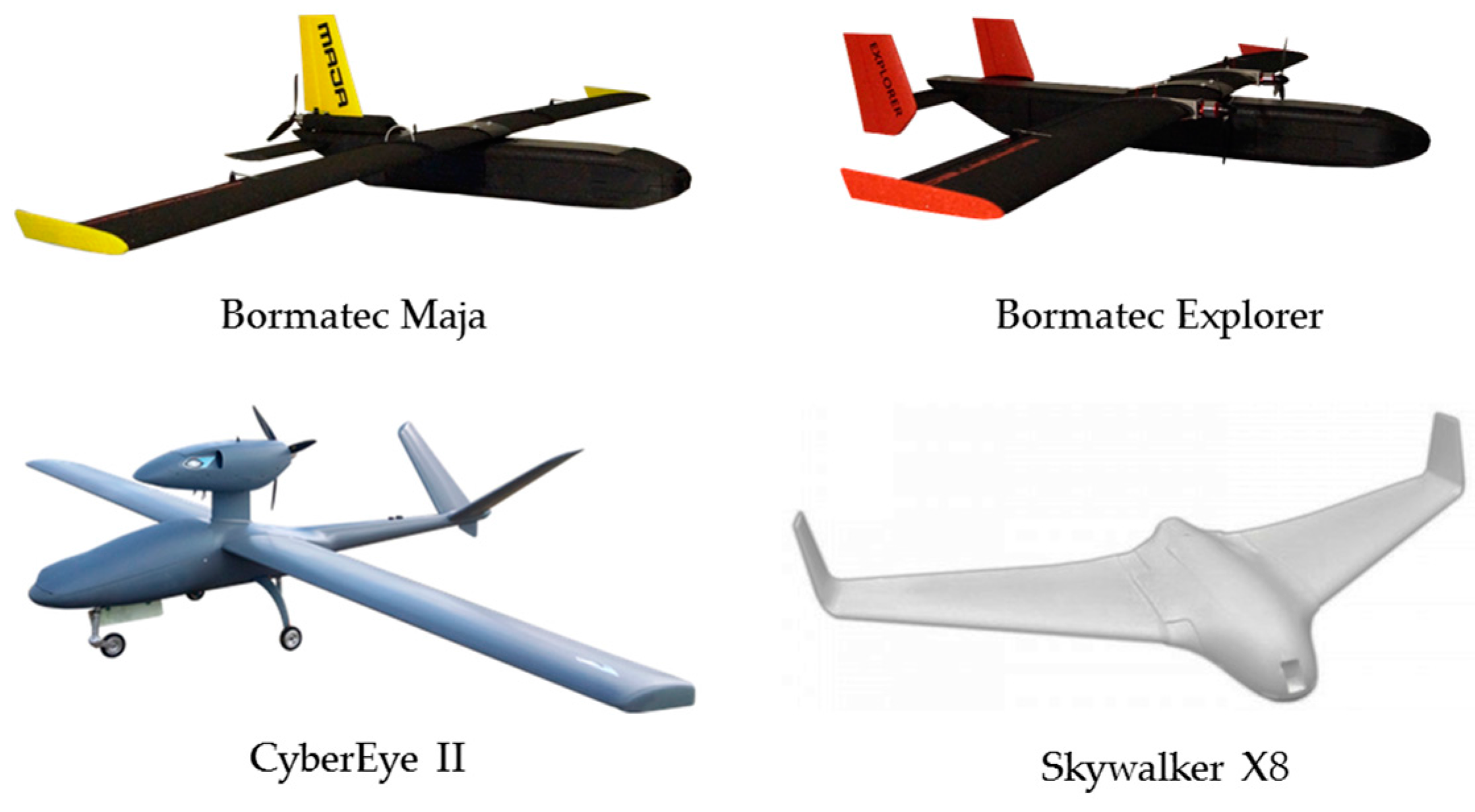
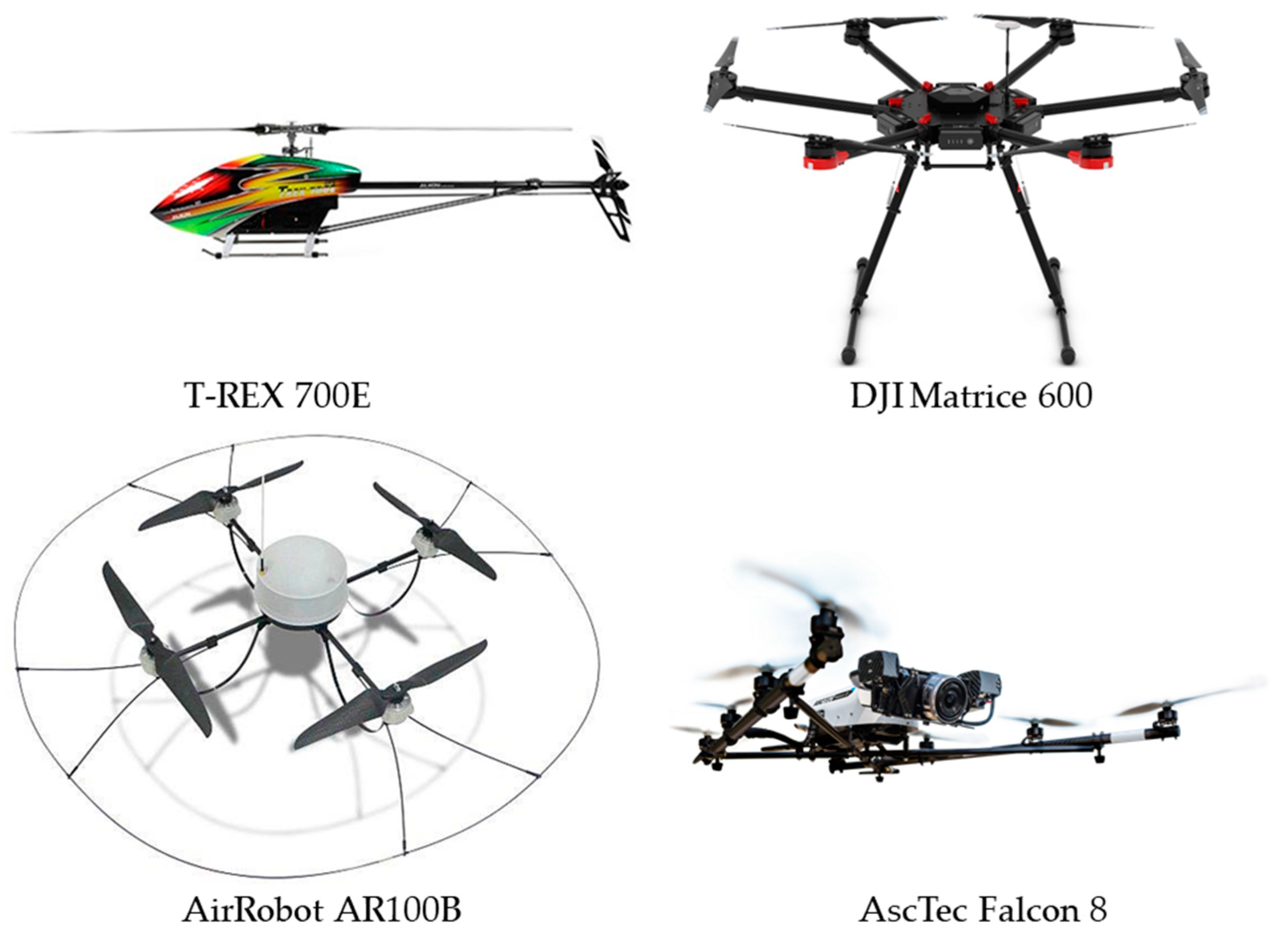
2. Classification of UASs

It is convenient to first introduce the five broad categories of UASs resulting from their military origin in the United Sates [27]. The transition of a UAS from one category to the next occurs if anyone of the limits to payload, altitude, or speed is surpassed. The first group has a maximum payload of less than 9.1 kg, an operating altitude of less than 366 m, and an airspeed of less than 185 km h−1. The second group has a payload between 9.2 and 25 kg, an operating altitude of less than 1067 m, and an airspeed of less than 463 km h−1. The remaining three categories have takeoff loads greater than 25 kg and a maximum of 599 kg. Their altitudes can reach up to 5.5 km (and above), with no limits to the airspeed. The applications that can be carried out with a UAS are linked to the category that it belongs to. Large UASs are capable of performing advanced tasks, flying long distances, and carrying heavy payloads. However, these large UASs (for payloads ≥25 kg) are not practical for atmospheric sampling at low altitudes. While the performance of small vehicles is relatively more limited than for large UASs, the great availability of these inexpensive models makes them especially attractive for research applications. The fact that UASs from the first two categories (with payloads ≤25 kg) are battery operated (and combustion fee) makes them the preferred choice for trace gas detection.
Aside from the previous classification, there is a more recent and specific one that breaks down UASs into seven groups [25]: (1) micro UAS (MUAS); (2) vertical take-off and landing (VTOL); (3) low-altitude short endurance (LASE); (4) LASE close; (5) low-altitude long endurance (LALE); (6) medium-altitude long endurance (MALE); and, (7) high altitude long endurance (HALE). The UASs classified as LASE close, LALE, MALE, and HALE (groups 4 through 7) can reach altitudes up to ca. 1.5 km and all require substantial runways for take-off and landing. Because there are no battery-operated UASs that are capable of such tasks, these classes of UASs appear to be of low relevance for trace gas detection [25]. The first three categories (MUAS, VTOL, and LASE) are all viable options for trace gas monitoring. MUAS are defined by their miniature size (~15–20 cm) and ultra-light weight, with payloads of less than 50 g and flight times of 8–10 min [25].
In addition, UASs are also divided into fixed-wing and rotary-wing aircrafts, which respectively look like traditional airplanes and helicopters. Although fixed-wing aircrafts do not have the maneuverability and take off and landing convenience of rotary aircraft, they are more stable in severe weather conditions and tend to have more space for payload configurations [24,26]. Both fixed-wing and rotary-wing UASs can be used for trace gas monitoring if they are not propelled by internal combustion engines. Examples of fixed-wing UASs included in Figure 1 are the Bormatec Maja and Explorer, the CyberEye II, and the Skywalker X8.
Both Bormatec UASs (Maja and Explorer) are closely related but differ by having single and dual engine setups, respectively. The CyberEye II represents the style of a conventional fixed-wing UAS that can be adapted for low-cost trace gas detection. The Skywalker X8 is a practical alternative that provides useful payload capacity for small, light-weight trace gas sensors at a fraction of the cost of the other three UASs in Figure 1.
From the large variety of rotary-wing UASs available in the market, a few examples included in Figure 2 are the T-REX 700E helicopter, the DJI Matrice 600, the AirRobot AR100B, and the AscTec Falcon 8. The T-REX 700E represents the traditional helicopter with one central rotor, and a secondary rotor on the tail of the aircraft. The DJI Matrice 600 is a lightweight hexacopter, with its rotors distributed in a circular pattern. The AirRobot AR100B is a quadcopter, also with its rotors in a circular array. The AscTec Falcon 8 is an octocopter with an alternative linear array of rotors. Because the upward force of the UAS is proportional to the diameter and number of rotors, the primary reason for adding extra rotors to the aircraft is to provide a greater lift [26].
However, it must be noted that adding rotors increases battery consumption and results in shorter flight times. Thus, a primary consideration for maximizing flight duration for a given payload is to optimize the number of rotors needed.
VTOLs are typically rotary-wing UASs that have the obvious advantage of near-instant deployment. Thus, VTOLs are versatile for field operations where runways are not an option. Given that the flight time for this class is limited from 20 to 60 min, a VTOL is an ideal platform to deploy sensors as close to the source as possible [25]. The maneuverability of VTOLs is also one of its strengths; the ability to hover in one location and reverse is advantageous. However, there are numerous types of VTOLs (e.g., helicopter, quadcopter, hexacopter, octacopter), each of which creates a unique downwash that can make gas detection and quantification complex [25].
LASEs are the most diverse class of UASs, and are characterized by simplicity and ease of use. The wingspans are limited to 3 m, and offer payloads from 2 to 5 kg. These UASs can be hand-launched or catapult-launched, and offer flight times from 45 to 120 min. This class of UASs can also be fit with autopilot features that offer the advantage of pre-planned flight patterns to ensure systematic sampling.
In summary, selecting the most appropriate UAS for sampling in the lower atmosphere requires consideration of the mission objectives, environmental conditions, and budget. The frame of the selected UAS model requires alteration for carrying the trace gas detection system to be deployed. Different sensor technologies for trace gas detection are discussed below.

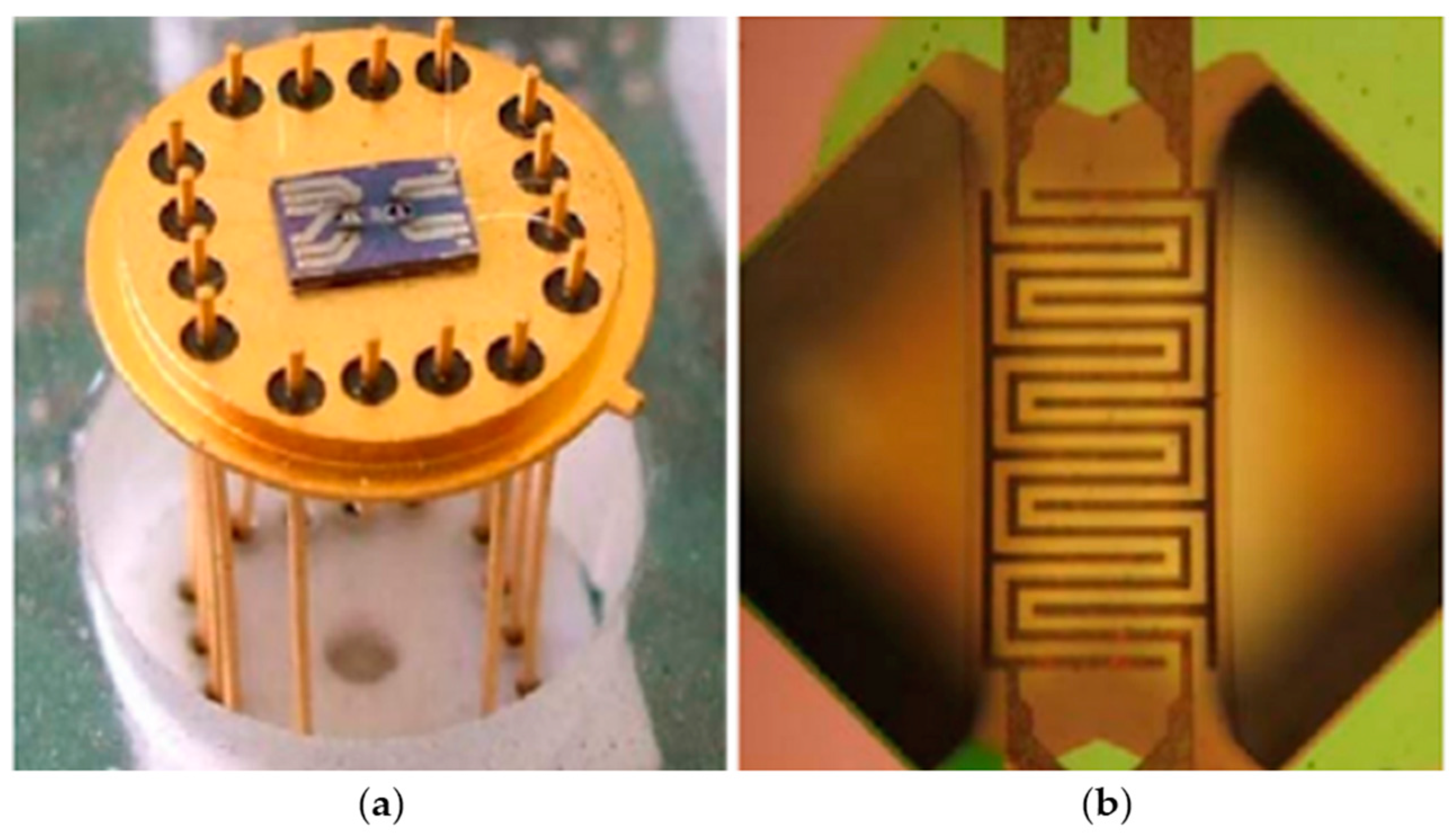
3. Sensors for Trace Gases

There are many different types of sensors that can be mounted into a UAS for detecting trace gases in the lower atmosphere. The most common methods are electrochemical, photoionization, infrared (IR) laser-absorption, semiconductor, and catalytic detection. Although each method is fundamentally different, all of the sensor types must be able to detect background atmospheric concentration levels and also have a dynamic range that spans the range of gas concentrations expected in the field. The useful detection limits and expect mixing ratio ranges for a number of trace atmospheric gases of interest to the U.S. Environmental Protection Agency (EPA) are presented in Table 1 [28].
A bias and precision of ±30% is reasonable for hotspot identification and characterization purposes; for supplementary network monitoring, a bias and precision of <20% is necessary for further investigation [28]. Another aspect to consider with trace gas sensors is the response to rotor turbulence. The impact of rotor turbulence with respect to detecting trace gas concentrations with sensors onboard UASs is relatively unexplored. A handful of publications present some computational fluid dynamic (CFD) analysis in a general context of mapping quadrotor downwash [29,30,31], but there are limited publications that include a CFD analysis for sensor placement [32]. Furthermore, the computational resources are not currently available to run detailed simulations that include the effect on local gas concentrations, thus the analysis of how gas concentrations are affected by UAS rotor turbulence is still something that needs to be studied. Even though the scope of these simulations is limited, they all show a general consensus on the location of the maximum and minimum airflows around the aircraft so some useful conclusions can be drawn from them. There are a few options when considering sensor placement. The first is to place the sensors outside the range of the rotor turbulence entirely, but at the cost of adding significant complexity, weight, and affecting the center of gravity. The second option is to minimize the airflow around the sensor on the UAS. The center of the fuselage above and below the aircraft appears to be the optimal placement to minimize air disturbances around the sensor, and thus are ideal locations for sensor placement. If the sensors are not used to gather luminosity measurements and/or are highly sensitive to UV light/temperature, locating them under the fuselage of the aircraft appears to be an ideal solution. A third possible solution is to isolate the sensor from rotor downwash entirely, and pump the air in with a sample inlet clear of the turbulence. The solution to be employed depends on the payload capacity of the UAS and the dependence of the instrument on air turbulence.
Electrochemical type sensors are commonly used for the detection of toxic gases as they pass through a semi-permeable membrane and undergo a redox reaction at the working electrode [33]. The resulting electrical current between the working and reference electrodes can be calibrated to provide the concentration of the desired gas. A typical problem associated to the use of electrochemical sensors is its cross sensitivity to other gases if the choice of membrane has not been carefully considered. Although, new and promising calibration methods are currently being developed to correct for sensor dependences on variable environmental conditions (i.e., temperature and relative humidity) [34]. Photoionization detectors commonly incorporate a durable 10.6 eV UV lamp to ionize volatile organic compounds (VOCs) [35]. The ejected electrons resulting from the photoionization of VOCs produce an electrical current that is directly proportional to concentration of the volatile species. While the sensitivity of this technique extents to low ppbv mixing ratios, the signal corresponds to the sum of all gases with an ionization potential that lies below the threshold set by the lamp’s photon energy.
The principle of operation for IR laser-absorption sensors is not different from a bench-top spectrometer [36,37]. As the laser beam passes through the atmosphere, a detector measures the loss in radiation intensity as a function of wavenumber. The loss of radiation intensity relative to the reference beam (or the same beam at a different wavelength) can provide the concentration of gases, while the wavelength of light absorbed provides the identity of the gas. The advantage of this technique is to sample large volumes for analysis because the sensor does not need to come in contact with the gas.
Semiconductor type sensors commonly use a tin or tungsten oxide film, which is saturated with adsorbed oxygen species (O2, O, O2−) in clean air [38]. The presence of oxygen on the film creates a high potential between the sensor and air. However, the presence of reducing gases results in the desorption of O2(g), which lowers the potential and allows for current to flow through the sensor. This change in resistivity within the sensor is the principle that can be used to measure the concentration of a gas. Lastly, catalytic sensors operate using two parts, known as beads, which are connected in a Wheatstone bridge circuit [39]. One bead has a catalytic material that is reactive to combustible gases and the other bead is not reactive because it is made of an inert material. The heat produced as combustible gases react with the catalyst causes an increase in resistivity of the catalytic bead. The circuit is designed to produce a voltage output (from the relative change in resistivity), which can be measured and is proportional to the concentration of the gas of interest.

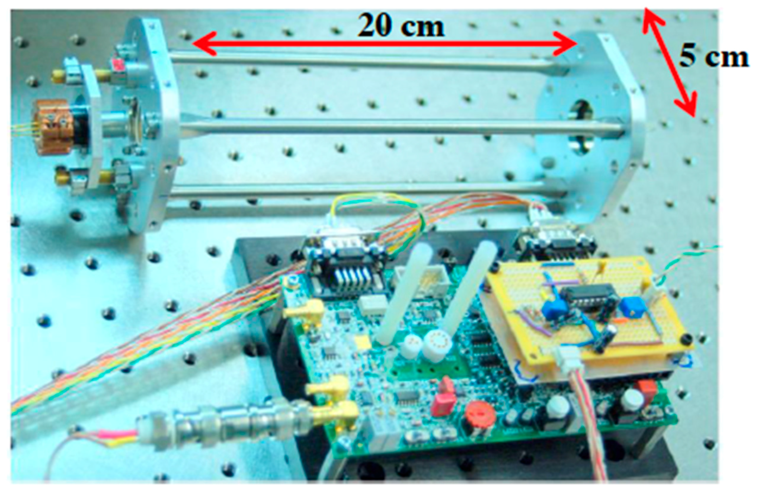
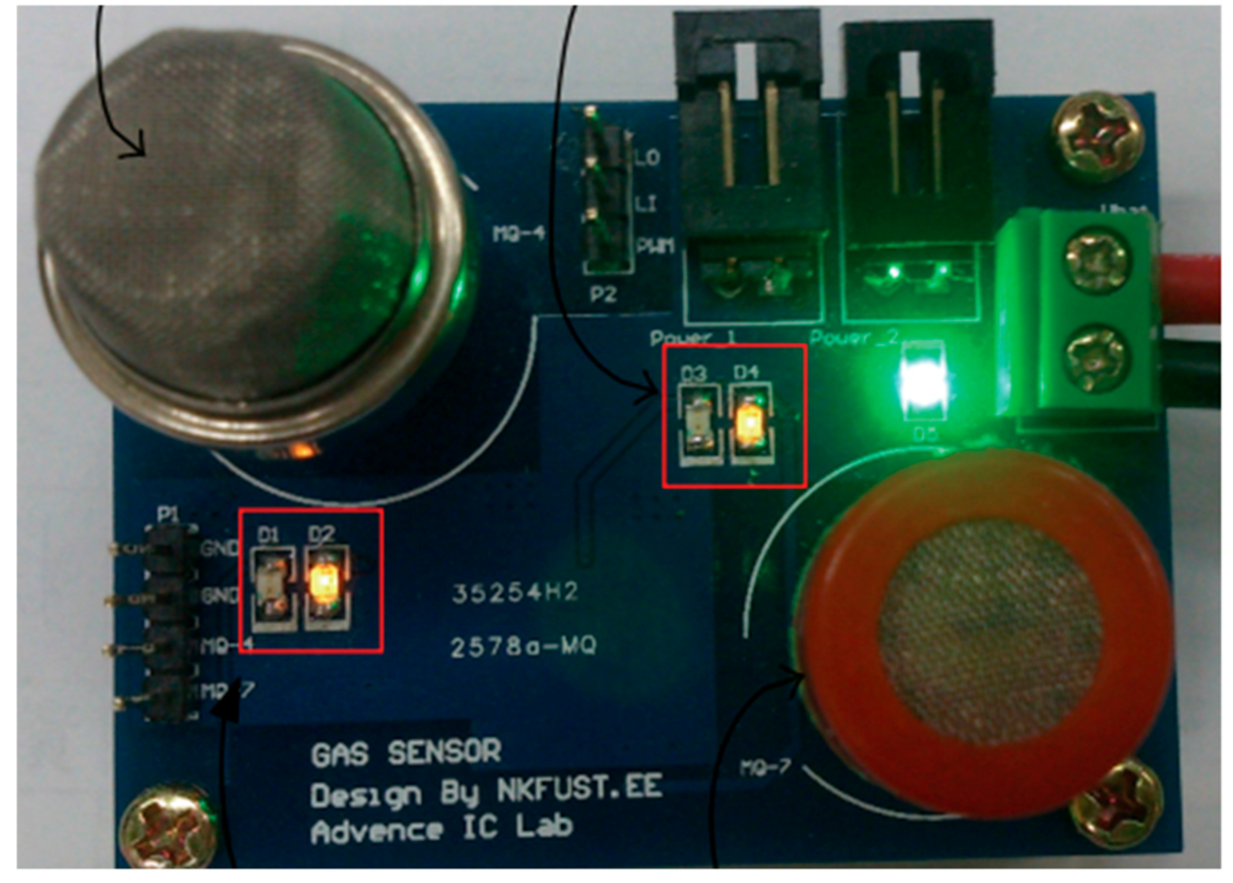
4. Implementation of Sensor Technology Onboard UASs

Several different categories and models of UASs have been introduced above and the significant factors for selecting between them are size, range, payload, and whether it is a fixed-wing or rotary-wing vehicle. These UASs can be modified to include sensors for monitoring trace tropospheric gases at low altitudes, as demonstrated in recent experimental efforts that have been successfully employed three different sensor technologies: (1) a portable IR laser-absorption spectrometer; (2) two semiconductor sensors; and, (3) a catalytic type sensor.
The first technology implemented has used a robust optical setup for IR laser absorption spectrometry to quantify GHGs using a photodetector [40,41]. This optical application includes the low-power vertical cavity surface emitting laser (VCSEL), as displayed in Figure 3, which probes the near-infrared region to identify GHGs such as CO2 and CH4 [40,41]. However, this method suffers interference from absorption by water vapor (H2O). Thus, wavelength modulation spectroscopy has been employed to further resolve the overlapping signals from different gases [40]. In addition, a cylindrical multi-pass cell with gold-coated mirrors has been used for increasing the optical path of the laser beam reaching the photodetector. This optical setup has been mounted into the T-REX 700E helicopter (Figure 2) for low altitude flights with a total payload <0.5 kg that lasted 5 to 10 min for measuring CO2 and CH4 at 4994.94 cm−1 and 4996.12 cm−1, respectively [40].
Measurements of CO2 and CH4 have been performed with the VSCEL technique, using wavelength modulation onboard a T-REX 700E helicopter (a VTOL UAS) at an air speed of 15 m s−1 that provides higher spatial resolution than possible by a conventional aircraft [40]. This temporal and spatial resolution data for CO2 and CH4 obtained at 2000–2003 and 1654 nm, respectively, is displayed in Figure 4 [40]. The mixing ratio of CO2 at a very low altitude (<5 m) has varied between 350 and 450 ppmv. For CH4, mixing ratio measurements in the range 1700–1900 ppbv have been detected from 10 to 40 m altitude. Importantly, knowing the humidity during these measurements enabled the correction of filed measurements after laboratory calibration that also included instrument stability and drift. The laboratory precision of the VSCEL sensor has been demonstrated to be ±0.06 ppmv for CO2 and ±0.9 ppbv for CH4. In the field, the precision of measurements is within ±0.1 ppmv and ±2 ppbv for CO2 and CH4, respectively. Because many gases absorb in the infrared range, the application of this technique to quantify other trace gases could be expanded.
The second technology that has been tested employs semiconductor sensors to quantify the presence of GHGs and VOCs from changes in resistivity [26]. This technology has been demonstrated in a micro electro mechanical system (MEMS) with metal oxide (MOX) gas sensors that were customized with micromachining techniques for UASs. The advantages of using MEMS with MOX, e.g., made of tungsten trioxide (WO3), such as that displayed in Figure 5, comprise a reduction in the payload and power intake of the sensor, making it practical for mobile VOC detection. These sensor arrays can potentially allow simultaneous monitoring of several different compounds, including CO2, NO2, and SO2 [26]. For practical applications, the sensor has been integrated into a microcontroller and mounted into a UAS [26], such as the DJI hexacopter in Figure 2, for carrying a payload of 0.3 kg during 15-min flights when powered by two parallel 9 V batteries [26].
Among the trace gases that could be detected by the MEMS MOX sensors, a VTOL UAS has facilitated monitoring the release of the VOC isopropyl alcohol over an open field [26]. Preliminary results show that VOCs have an impact in sensor response, and that GHGs can be detected in the turbulent flow of a VTOL UAS [26]. However, the registered change in the output of the sensor corresponds to an absolute response to all VOC present, and no selectivity for different gases has been demonstrated [26]. Indeed, the results suggest that further development and laboratory calibration would be needed to identify and quantify trace gases in the atmosphere with this type of sensors.
In addition, the highly selective MQ-4 semiconductor sensor for CH4 detection (Figure 6) [42] is a good candidate for deployment with UASs. Although the MQ-4 sensor has been designed to monitor CH4, a lower selectivity for detecting the gases propane and butane is possible [42]. The cheap and commercially available MQ-4 sensor can be easily paired to a microcontroller mounted to either a fixed-wing or rotary-wing UAS. However, a challenge faced by this current technology is the need to perform accurate calibrations under variable temperature and relative humidity. MUASs devices appear to be an ideal platform for deploying the small and lightweight MQ-4 sensor. Employing multiple MUASs in a swarm can potentially provide real-time tridimensional (3D) spatial resolution of CH4 concentrations in a cost-effective manner. This technique could be also applied in a discrete manner in urban settings, but with limitations such as for short flight times or the inability to fly in strong winds [25]. In addition to CH4, the MQ-4 sensor can also detect propane, hydrogen (H2), carbon monoxide (CO), ethanol, smoke, and air.
For calibration purposes, the measured resistivity of the MQ-4 sensor (Rs) is expressed relative to the reference signal for 1000 ppmv CH4 in air (Ro) [43]. Such information for the MQ-4 sensor is available, e.g., at 20 °C, for 65% relative humidity, 21% O2 mixing ratio, and a load resistance of 2 × 10⁴ Ω [43], and varies with humidity and temperature. Therefore, in order to obtain useful CH4 mixing ratios with this sensor, calibrations across several temperature and humidity conditions are needed [43]. A general concern for employing this sensor in the presence of multiple gases is the lack of specificity to differentiate and quantify several gases simultaneously. However, the MQ-4 sensor can still provide useful information because of its much sharper response for CH4 than for other gases that are certainly not in excess.
Interestingly, trace gas emissions of CH4 from a landfill have been successfully studied following a racetrack pattern, which can be accomplished by flying the Skywalker X8 in Figure 1, a LASE UAS, perpendicular to the direction of the wind [44]. Thus, the quantification of CH4 using this UAS should be attempted in the future with a Skywalker X8 equipped with both the MQ-4 sensor for CH4 and the MEMS MOX sensor for the detection of other GHGs and VOCs. However, the Skywalker X8 is not robust enough for most laser absorption spectroscopy techniques, such as the VCSEL.
This section lastly covers a catalytic type sensor that has already been proved in commercially handheld gas detectors. Catalytic type gas sensors have long been available on gas monitoring devices developed for industry settings, where a small gas leak can be dangerous or even deadly. Existing devices have evolved to measure up to six gases simultaneously but they need to be modified to fit the needs for onboard sensing with UASs. An example of such adaptation has been attempted with an AirRobot AR100B (Figure 2) that is capable of flying for 30 min with a payload of 0.2 kg to measure mixing ratios of CO2 and SO2 over a volcanic crater in the Canary Islands [45]. The method was laboratory validated only for CO2 using a test chamber filled with clean air [45]. Importantly, the device provides the option to exchange the catalytic sensors for toxic gases by electrochemical type sensors or even photoionization detectors (PIDs) for combustible gases.
There are further examples of sensors used for trace gas deployment that do not explicitly stick to one type of detection mechanism, several examples of UAS deployments for atmospheric monitoring can be found in the literature [46,47,48,49,50,51,52,53,54].

5. Interface for Integration of Analytical Sensors into UASs and Initial Cost Considerations

The miniaturization of sensor packages can be enabled by printed circuit boards (PCBs). Software such as Fritzing allows for the design and printing of unique circuit boards that can integrate several gas sensors into a small, lightweight package [55]. These PCBs are generally battery powered, although the development of radio frequency identification (RFID) tags provides a promising future for wireless powering of these low-power consuming devices. These PCBs are programmed with microcontrollers or microcomputers on single integrated circuits. Typical microcomputers employed combine a processing core, RAM, and an operating system (e.g., Linux) to operate microcontrollers. Programing of the microcomputer is enabled with software using a keyboard and monitor connected to the device. Among the options for collecting data from the sensor package, there are two common reliable practices: (1) to store data on a SD card for later retrieval and analysis; and, (2) to wirelessly transmit data in real time to an online database or back to the users’ computer via Wi-Fi or Bluetooth.
The costs of UASs such as MAV, LASE, and VTOL can vary widely based on the airframe, the GPS navigation system to be added, the autopilot and telemetry system, and motor/battery combination chosen. Airframe costs can range from $250 to $5000 depending on the type and complexity of the aircraft. Although the GPS navigation system can be costly (e.g., ~$4000), it is a significant component to determine the quality of flight. The autopilot systems can vary significantly due to the quality of the flight control with prices starting at $50 that for higher-end systems increases to $300. Batteries for UASs range from $65 to $200, but the number of batteries required for operation could range from 1 to 6 depending on the number of rotors. Additionally, spare batteries are required to keep the UAS in flight as much as possible, what impacts the total battery cost to range between $65 and $1200. In addition, battery chargers cost $60–200. For those airframes that do not come equipped with a motor, an additional investment of $30–120, depending on size and rating, is needed. Many users of UASs also find it useful to have onboard digital-to-analog (DAC) converters, which cost between $200 and $300. Thus, just for the total cost of a UAS, a figure of $5000 to $12,000 can be obtained.
The cost of sensor packages can also vary slightly based on the type of microcontroller/microcomputer used, the number and type of analytical sensors deployed, and how the device is powered. The microcontrollers/microcomputers cost $25–40, but it may require multiple shields (or a PCB) to incorporate data transmission, as well as a memory card, which could cost an additional $35. Batteries are approximately $20 each, and at least two batteries are required per unit to run continuously all day. The price of analytical gas sensors certainly depends on the detection method chosen. Many electrochemical, photoionization, catalytic, and semiconductor type sensors are readily commercially available, but the price definitely reflects the quality of the sensor. Many gas sensors are available for $5–10, however for the highest-quality gas sensors, the price range can jump to $300–1000. There is a large variety of gas sensors priced in-between as well, but again the price reflects the quality. It is recommended to verify the following information is available when purchasing sensors: calibration, lifetime, sensitivity, response time, and size/weight. Lastly, there are no commercially available IR laser-absorption instruments. This means that the instruments reviewed above were custom built for that UAS, making cost estimates difficult. However, given the costs of lasers, optical cables, gas chambers, and detectors, it is the most expensive method to deploy.

6. Restrictions and Regulations in the United States and European Countries

According to the U.S. Federal Aviation Administration (FAA), any model aircraft under 55 lbs (25 kg) is considered as a small unmanned aerial system (sUAS) under the addition of Part 107 to Title 14 Code of Federal Regulations. Part 107 states that the pilot in command (PIC) must have a proper certification requirement if a sUAS is operated for non-hobby purposes. The FAA defines such operations as: agricultural monitoring/inspection, research and development, educational/academic uses, powerline/pipeline inspection in mountainous terrain, antenna inspections, bridge inspections, aiding search and rescue, wildlife nesting area and evaluations, and aerial photography [56]. Flying a sUAS for any of these objectives requires that the pilot obtains a “Remote Pilot of Small Unmanned Aircraft System” license, and that the unmanned aircraft be registered with the FAA. The license examination can be taken at any of the local certified testing stations listed on the FAA website [57] and the aircraft can be registered at the FAA website [58]. Upon obtaining the part 107 license, the individual may now legally conduct research operations. However, there are some considerations one must take to ensure that the provisions of part 107 are followed. When flying, there must always be at least one PIC per aircraft. This person may not be the individual at the controls of the aircraft, but they are in charge and responsible for that operation. The PIC must maintain line of sight of their aircraft, unless a visual observer (VO) is used. The sole job of the VO is to watch the sUAS and report any potential dangers back to the PIC. The PIC, VO, and individual at the controls must be able to remain within eyesight and be able to communicate at all times with the sUAS. First person view (FPV) style optics do not meet the line of sight requirements, but may be used in addition. Operations are to begin and end at civil twilights (30 min before sunrise and 30 min after sunset) and shall not exceed 121.9 m above ground level or 160.9 km h−1 groundspeed. Lastly, it is particularly important to ensure that external load operations are attached firmly, and will not adversely affect the center of gravity or flight time in such a way that will jeopardize flight operations. It is possible to conduct operations outside of normal FAA guidelines through a Certificate of Waiver or Authorization (COA). For example, a COA would be necessary to fly in the dark before sunrise to obtain a baseline before atmospheric boundary layer inversion, or to fly above 121.9 m for vertical profiles. A COA is obtained by application to the FAA. The applicant must demonstrate that the operation can safely be conducted under the terms of the COA, and will be allowed to operate outside normal FAA guidelines.
The European Aviation Safety Agency (EASA) is in the process of creating their own unified standard for UASs. As of 5 April 2017, the first official draft pertaining to UASs regulation has been published [59]. By the end of 2017 the proposal will be brought to the commission, it will be finalized by mid-2018, and implemented in 2019. The EASA categorizes operations based on the particular risk associated, and the type/size/performance of unmanned aircraft used. The regulations are dependent on both the class of the operation and the UAS.
There are three classes of operations defined by the EASA: open, specific, and certified. Open operations are defined as not needing prior approval of competent authority, and have little to no risk. Open operation regulations are aimed towards the general public, and apply to all member states of the European Union (EU). Regulations of open operations will not be explained in detail, but it is advised to become familiar with the different subclasses of open operations (flying over people, flying near people, and flying far from people) and classes of UASs (C0, C1, C2, C3, C4, and privately built) [59].
Specific operations, due to the risk involved, must obtain flight authorization from competent authorities. The EASA will issue standard scenarios for specific operations that the member states of the EU can choose to adopt or change. Either way, member states shall designate a governing body for specific operations (similar to the way the United States of America designates the FAA). Permission for specific operations can be granted from the competent authorities by submitting a risk-assessment analysis before each flight. However, the operator can authorize their own operations if they possess a Light UAS Operator Certificate (LUC). As mentioned above, regulations can vary between member states, so it is advised to go to the corresponding EU member state (if applicable) and enquire about their regulations for specific operations with the goal of obtaining a LUC to authorize the operations needed. Table 2 summarizes the regulations for unmanned operations of selected European countries [60].
Lastly, certified operations are considered high risk and include large or complex UAS operating continuously over open assemblies of people, or operating beyond visual line of sight in high density airspace. Certified operations also include UASs that are used for transporting dangerous goods or people. These operations are more closely governed by the laws of manned aircraft, and require the certification of the operator and the aircraft, as well as the licensing of the flight crew. Certified operations are outside the scope of this perspective and will not be discussed further.
There are many other countries to consider all of the developing legislation in depth (i.e., China, Australia, Canada, etc.) in this perspective. Thus, if more information is needed, there are resources developed by the International Civil Aviation Organization (ICAO) that provides links to aviation authorities worldwide. Specifics on unmanned aircraft regulations can be found therein [61,62].

7. Conclusions

Monitoring trace tropospheric gases with UASs is a promising methodology for atmospheric chemistry applications. MAVEs, VTOL, and LASE aircrafts are the most practical UASs for trace gas monitoring. Specifically, those UASs with wingspans under 3 m for payloads <5 kg are the best compromise between cost and convenience for deploying sensors. These UASs offer altitude capabilities of a few hundred meters with flight times ranging from 30 min to 2 h. Examples of how these UASs can carry lightweight, low-power, cheap trace gas sensors have been provided. However, further progress is needed to achieve the accurate quantification of a mixture of gases under variable environmental conditions. The most expensive part of integrating analytical sensors into UASs is also the most difficult to quantify, because time and investment for research and development of these new analytical methods of gas detection are needed. Numerous hours, days, and months of innovation in the laboratory and application in the flying field will need to be invested, which is costly and nearly impossible to put a dollar amount for comparison to the cost of the individual components. Future progress in this area will be possible when new instruments that are integrated into UASs are developed, calibrated, and validated.

Acknowledgments

This research was supported by the U.S. National Science Foundation under RII Track-2 FEC award No. 1539070. Special thanks to the Collaboration Leading Operational Unmanned Aerial Systems Development for Meteorology and Atmospheric Physics (CLOUDMAP) consortium for promoting and sharing knowledge about UASs.

Author Contributions

All authors conceived and wrote the paper.

Conflicts of Interest

The authors declare no conflict of interest.

References

  1. Seinfeld, J.H.; Pandis, S.N. Atmospheric Chemistry and Physics: From Air Pollution to Climate Change, 3rd ed.; Wiley: Hoboken, NJ, USA, 2016; p. 1152. ISBN 1118947401. [Google Scholar]
  2. Fowler, D.; Pilegaard, K.; Sutton, M.; Ambus, P.; Raivonen, M.; Duyzer, J.; Simpson, D.; Fagerli, H.; Fuzzi, S.; Schjørring, J.K. Atmospheric composition change: Ecosystems–atmosphere interactions. Atmos. Environ. 2009, 43, 5193–5267. [Google Scholar] [CrossRef]
  3. Xi, X.; Johnson, M.S.; Jeong, S.; Fladeland, M.; Pieri, D.; Diaz, J.A.; Bland, G.L. Constraining the sulfur dioxide degassing flux from Turrialba volcano, Costa Rica using unmanned aerial system measurements. J. Volcanol. Geotherm. Res. 2016, 325, 110–118. [Google Scholar] [CrossRef]
  4. Robock, A. Volcanic eruptions and climate. Rev. Geophys. 2000, 38, 191–219. [Google Scholar] [CrossRef]
  5. Rowland, F.; Molina, M.J. Chlorofluoromethanes in the environment. Rev. Geophys. 1975, 13, 1–35. [Google Scholar] [CrossRef]
  6. NASA. Ozone Hole Watch. Available online: https://ozonewatch.gsfc.nasa.gov/ (accessed on 12 January 2017).
  7. Illingworth, S.; Allen, G.; Percival, C.; Hollingsworth, P.; Gallagher, M.; Ricketts, H.; Hayes, H.; Ładosz, P.; Crawley, D.; Roberts, G. Measurement of boundary layer ozone concentrations on-board a Skywalker unmanned aerial vehicle. Atmos. Sci. Lett. 2014, 15, 252–258. [Google Scholar] [CrossRef]
  8. World Health Organization. Preventing Disease Through Healthy Environments. Available online: http://www.who.int/ipcs/features/air_pollution.pdf (accessed on 4 July 2017).
  9. World Health Organization. Ambient (Outdoor) Air Quality and Health. Available online: http://www.who.int/mediacentre/factsheets/fs313/en/ (accessed on 4 July 2017).
  10. Chahine, M.T.; Pagano, T.S.; Aumann, H.H.; Atlas, R.; Barnet, C.; Blaisdell, J.; Chen, L.; Divakarla, M.; Fetzer, E.J.; Goldberg, M. AIRS: Improving weather forecasting and providing new data on greenhouse gases. Bull. Am. Meteorol. Soc. 2006, 87, 911–926. [Google Scholar] [CrossRef]
  11. Clow, J.; Smith, J.C. Using Unmanned Air Systems to Monitor Methane in the Atmosphere. Available online: https://ntrs.nasa.gov/search.jsp?R=20160003620 (accessed on 12 January 2017).
  12. Wainner, R.T.; Frish, M.B.; Green, B.D.; Laderer, M.C.; Allen, M.G.; Morency, J.R. High Altitude Aerial Natural Gas Leak Detection System. Available online: https://www.osti.gov/scitech/biblio/921001 (accessed on 14 January 2017).
  13. Heard, D. Analytical Techniques for Atmospheric Measurement; Blackwell Publishing Ltd.: Oxford, UK, 2006; p. 528. ISBN 978-140-512-357-0. [Google Scholar]
  14. Crosson, E. A cavity ring-down analyzer for measuring atmospheric levels of methane, carbon dioxide, and water vapor. Appl. Phys. B 2008, 92, 403–408. [Google Scholar] [CrossRef]
  15. Brady, J.M.; Stokes, M.D.; Bonnardel, J.; Bertram, T.H. Characterization of a Quadrotor Unmanned Aircraft System for Aerosol-Particle-Concentration Measurements. Environ. Sci. Technol. 2016, 50, 1376–1383. [Google Scholar] [CrossRef] [PubMed]
  16. Renard, J.-B.; Dulac, F.; Berthet, G.; Lurton, T.; Vignelle, D.; Jégou, F.; Tonnelier, T.; Thaury, C.; Jeannot, M.; Couté, B. LOAC: A small aerosol optical counter/sizer for ground-based and balloon measurements of the size distribution and nature of atmospheric particles—Part 2: First results from balloon and unmanned aerial vehicle flights. Atmos. Meas. Tech. Discuss. 2015, 8, 1261–1299. [Google Scholar] [CrossRef]
  17. Renard, J.-B.; Dulac, F.; Berthet, G.; Lurton, T.; Vignelles, D.; Jégou, F.; Tonnelier, T.; Jeannot, M.; Couté, B.; Akiki, R. LOAC: A small aerosol optical counter/sizer for ground-based and balloon measurements of the size distribution and nature of atmospheric particles—Part 1: Principle of measurements and instrument evaluation. Atmos. Meas. Tech. 2016, 9, 1721–1742. [Google Scholar] [CrossRef] [Green Version]
  18. Leoni, C.; Hovorka, J.; Dočekalová, V.; Cajthaml, T.S.; Marvanová, S.A. Source Impact Determination using Airborne and Ground Measurements of Industrial Plumes. Environ. Sci. Technol. 2016, 50, 9881–9888. [Google Scholar] [CrossRef] [PubMed]
  19. Axisa, D.; DeFelice, T.P. Modern and prospective technologies for weather modification activities: A look at integrating unmanned aircraft systems. Atmos. Res. 2016, 178, 114–124. [Google Scholar] [CrossRef]
  20. Rango, A.; Laliberte, A.; Herrick, J.E.; Winters, C.; Havstad, K.; Steele, C.; Browning, D. Unmanned aerial vehicle-based remote sensing for rangeland assessment, monitoring, and management. J. Appl. Remote Sens. 2009, 3, 33515–33542. [Google Scholar] [CrossRef]
  21. National Purchase Diary. Year-Over-Year Drone Revenue Soars, According to NPD. Available online: https://www.npd.com/wps/portal/npd/us/news/press-releases/2016/year-over-year-drone-revenue-soars-according-to-npd/ (accessed on 20 January 2017).
  22. Bretschneider, T.R.; Shetti, K. UAV-based gas pipeline leak detection. In Proceedings of the Asian Conference on Remote Sensing, Nay Pyi Taw, Myanmar, 27–31 October 2014; Available online: http://www.a-a-r-s.org/acrs/index.php/acrs/acrs-overview/proceedings-1?view=publication&task=show&id=1605 (accessed on 14 January 2017).
  23. Federal Aviation Administration. Operation and Certification of Small Unmanned Aerial Vehicles. Available online: https://www.federalregister.gov/documents/2016/06/28/2016-15079/operation-and-certification-of-small-unmanned-aircraft-systems (accessed on 2 June 2017).
  24. Villa, T.F.; Gonzalez, F.; Miljievic, B.; Ristovski, Z.D.; Morawska, L. An Overview of Small Unmanned Aerial Vehicles for Air Quality Measurements: Present Applications and Future Prospectives. Sensors 2016, 16, 1072. [Google Scholar] [CrossRef] [PubMed]
  25. Watts, A.C.; Ambrosia, V.G.; Hinkley, E.A. Unmanned aircraft systems in remote sensing and scientific research: Classification and considerations of use. Remote Sens. 2012, 4, 1671–1692. [Google Scholar] [CrossRef]
  26. Rossi, M.; Brunelli, D.; Adami, A.; Lorenzelli, L.; Menna, F.; Remondino, F. Gas-Drone: Portable gas sensing system on UAVs for gas leakage localization. In Proceedings of the IEEE SENSORS 2014, Valencia, Spain, 2–5 November 2014; pp. 1431–1434. Available online: http://ieeexplore.ieee.org/document/6985282/ (accessed on 21 January 2017).
  27. UAS Task Force. Unmanned Aircraft System Airspace Integration Plan. Available online: http://www.acq.osd.mil/sts/docs/DoD_UAS_Airspace_Integ_Plan_v2_(signed).pdf (accessed on 13 June 2017).
  28. Environmental Protection Agency. Air Sensor Guidebook. Available online: https://cfpub.epa.gov/si/si_public_file_download.cfm?p_download_id=519616 (accessed on 20 September 2017).
  29. Thibault, S.E.; Holman, D.; Trapani, G.; Garcia, S. CFD Simulation of a Quad-Rotor UAV with Rotors in Motion Explicitly Modeled Using an LBM Approach with Adaptive Refinement. In Proceedings of the 55th AIAA Aerospace Sciences Meeting, Grapevine, TX, USA, 9–13 January 2017; p. 0583. [Google Scholar]
  30. Yoon, S.; Lee, H.C.; Pulliam, T.H. Computational Analysis of Multi-Rotor Flows. In Proceedings of the 54th AIAA Aerospace Sciences Meeting, San Diego, CA, USA, 4–8 January 2016. [Google Scholar]
  31. Poyi, G.T.; Wu, M.H.; Bousbaine, A. Computational fluid dynamics model of a quad-rotor helicopter for dynamic analysis. IJREAT Int. J. Res. Eng. Adv. Technol. 2016, 4, 32–41. [Google Scholar]
  32. Roldán, J.J.; Joossen, G.; Sanz, D.; del Cerro, J.; Barrientos, A. Mini-UAV based sensory system for measuring environmental variables in greenhouses. Sensors 2015, 15, 3334–3350. [Google Scholar]
  33. Rajeshwar, K.; Ibanez, J.G. Enivronmental Electrochemistry: Fundamentals and Applications in Pollution Abatement; Academic Press, Inc.: San Diego, CA, USA, 1997; p. 776. ISBN 978-012-576-260-1. [Google Scholar]
  34. Cross, E.S.; Lewis, D.K.; Williams, L.R.; Magoon, G.R.; Kaminsky, M.L.; Worsnop, D.R.; Jayne, J.T. Use of electrochemical sensors for measurement of air pollution: Correcting interference response and validating measurements. Atmos. Meas. Tech. Discuss. 2017, 2017, 1–17. [Google Scholar] [CrossRef]
  35. Spinelle, L.; Gerboles, M.; Kok, G.; Persijn, S.; Sauerwald, T. Review of Portable and Low-Cost Sensors for the Ambient Air Monitoring of Benzene and Other Volatile Organic Compounds. Sensors 2017, 17, 1520. [Google Scholar] [CrossRef] [PubMed]
  36. Werle, P.; Slemr, F.; Maurer, K.; Kormann, R.; Mücke, R.; Jänker, B. Near-and mid-infrared laser-optical sensors for gas analysis. In Proceedings of the SPIE—Diode Lasers and Applications in Atmospheric Sensing, Seattle, WA, USA, 24 September 2002; pp. 101–114. Available online: http://proceedings.spiedigitallibrary.org/proceeding.aspx?articleid=1314311 (accessed on 21 January 2017).
  37. Fanchenko, S.; Baranov, A.; Savkin, A.; Sleptsov, V. LED-based NDIR natural gas analyzer. In IOP Conference Series: Materials Science and Engineering, Mykonos, Greece, 27–30 September 2015; IOP Publishing: Bristol, UK; Available online: http://iopscience.iop.org/article/10.1088/1757-899X/108/1/012036 (accessed on 10 February 2017).
  38. Moseley, P.T. Progress in the development of semiconducting metal oxide gas sensors: A review. Meas. Sci. Tech. 2017, 28, 82001–82016. [Google Scholar] [CrossRef]
  39. Karpov, E.Е.; Karpov, Е.F.; Suchkov, А.; Mironov, S.; Baranov, A.; Sleptsov, V.; Calliari, L. Energy efficient planar catalytic sensor for methane measurement. Sens. Actuators A Phys. 2013, 194, 176–180. [Google Scholar] [CrossRef]
  40. Khan, A.; Schaefer, D.; Tao, L.; Miller, D.J.; Sun, K.; Zondlo, M.A.; Harrison, W.A.; Roscoe, B.; Lary, D.J. Low power greenhouse gas sensors for unmanned aerial vehicles. Remote Sens. 2012, 4, 1355–1368. [Google Scholar] [CrossRef]
  41. So, S.; Sani, A.A.; Zhong, L.; Tittel, F.; Wysocki, G. Laser spectroscopic trace-gas sensor networks for atmospheric monitoring applications. In Proceedings of the ESSA Workshop, San Francisco, CA, USA, 16 April 2009; Available online: http://www.ruf.rice.edu/~mobile/publications/so09essa.pdf (accessed on 17 January 2017).
  42. Chen, M.-C.; Chen, C.-H.; Huang, M.-S.; Ciou, J.-Y.; Zhang, G.-T. Design of unmanned vehicle system for disaster detection. Int. J. Distrib. Sens. Netw. 2015, 784298–784306. [Google Scholar] [CrossRef]
  43. Hanwei Electronics. Specification Document for MQ-4 Gas Sensor. Available online: https://www.sparkfun.com/datasheets/Sensors/Biometric/MQ-4.pdf (accessed on 12 December 2016).
  44. Allen, G.; Gallagher, M.; Hollingsworth, P.; Illingworth, S.; Kabbabe, K.P.C. Feasibility of Aerial Measurements of Methane Emissions from Landfills. Available online: https://www.gov.uk/government/publications/aerial-measurements-of-methane-emissions-from-landfills (accessed on 12 January 2017).
  45. Bartholmai, M.; Neumann, P. Micro-Drone for Gas Measurement in Hazardous Scenarios. In Selected Topics in Power Systems and Remote Sensing, Tazikawa, Japan, 4–6 October; WSEAS Press: Cambridge, UK; pp. 149–152. Available online: http://www.wseas.us/e-library/conferences/2010/Japan/POWREM/POWREM-23.pdf (accessed on 2 July 2017).
  46. Alvear, O.; Zema, N.R.; Natalizio, E.; Calafate, C.T. Using UAV-Based Systems to Monitor Air Pollution in Areas with Poor Accessibility. J. Adv. Transp. 2017, 2017, 14. [Google Scholar] [CrossRef]
  47. Berman, E.S.F.; Fladeland, M.; Liem, J.; Kolyer, R.; Gupta, M. Greenhouse gas analyzer for measurements of carbon dioxide, methane, and water vapor aboard an unmanned aerial vehicle. Sens. Actuators B Chem. 2012, 169, 128–135. [Google Scholar] [CrossRef]
  48. Everts, S.; Davenport, M. Rise of the Machines. Chem. Eng. News 2016, 84, 32–33. [Google Scholar] [CrossRef]
  49. Everts, S.; Davenport, M. How Drones Help Us Study Our Climate, Forecast Weather. Chem. Eng. News 2016, 94, 34–36. [Google Scholar]
  50. Everts, S. Drones Detect Threats Such as Chemical Weapons, Volcanic Eruptions. Chem. Eng. News 2016, 94, 36–37. [Google Scholar]
  51. Malaver, A.; Motta, N.; Corke, P.; Gonzalez, F. Development and Integration of a Solar Powered Unmanned Aerial Vehicle and a Wireless Sensor Network to Monitor Greenhouse Gases. Sensors 2015, 15, 4072–4096. [Google Scholar] [CrossRef] [PubMed] [Green Version]
  52. Nathan, B.J.; Golston, L.M.; O’Brien, A.S.; Ross, K.; Harrison, W.A.; Tao, L.; Lary, D.J.; Johnson, D.R.; Covington, A.N.; Clark, N.N.; et al. Near-Field Characterization of Methane Emission Variability from a Compressor Station Using a Model Aircraft. Environ. Sci. Technol. 2015, 49, 7896–7903. [Google Scholar] [CrossRef] [PubMed]
  53. Selker, J.; Tyler, S.; Higgins, C.; Wing, M. Drone Squadron to Take Earth Monitoring to New Heights. EOS 2015, 96, 8–11. [Google Scholar] [CrossRef]
  54. Hurley, B. Report from SPIE 2017: Drones Spot Gas Leaks from the Sky. Available online: http://www.techbriefs.com/component/content/article/1198-ntb/news/news/26735-from-spie-laserbased-sensors-uavs-spot-methane-leaks (accessed on 4 October 2017).
  55. Knörig, A.; Wettach, R.; Cohen, J. Fritzing: A tool for advancing electronic prototyping for designers. In Proceedings of the 3rd International Conference on Tangible and Embedded Interaction, Regent, UK, 16–18 February 2009; pp. 351–358. Available online: http://dl.acm.org/citation.cfm?id=1517735 (accessed on 12 July 2017).
  56. Federal Aviation Administration. Operation and Certification of Small Unmanned Aircraft Systems. Available online: https://www.faa.gov/uas/media/RIN_2120-AJ60_Clean_Signed.pdf (accessed on 12 September 2017).
  57. Federal Aviation Administration. List of Commerical Testing Centers in Compliance with Part 107. Available online: https://www.faa.gov/training_testing/testing/media/test_centers.pdf (accessed on 12 September 2017).
  58. Federal Aviation Administration. sUAS Registration with FAA. Available online: https://registermyuas.faa.gov/ (accessed on 12 September 2017).
  59. European Aviation Safety Agency. Introduction of a Regulatory Framework for the Operation of Drones (A). Available online: https://www.easa.europa.eu/system/files/dfu/NPA%202017-05%20%28A%29_0.pdf (accessed on 14 September 2017).
  60. European Aviation Safety Agency. Introduction of a Regulatory Framework for the Operation of Drones (B). Available online: https://www.easa.europa.eu/system/files/dfu/NPA%202017-05%20%28B%29.pdf (accessed on 14 September 2017).
  61. International Civil Aviation Organization. Current State Regulations of Unmanned Aircraft. Available online: https://www4.icao.int/uastoolkit/Home/BestPractices (accessed on 14 September 2017).
  62. International Civil Aviation Organization. Civil Aviation Authorites Worldwide. Available online: https://www.icao.int/Pages/Links.aspx (accessed on 14 September 2017).
Figure 1. Examples of fixed-wing unmanned aerial systems (UAS) platforms for trace gas monitoring.
Atmosphere 08 00206 g001
Figure 2. Examples of rotary-wing UAS platforms for trace gas monitoring.
Atmosphere 08 00206 g002
Figure 3. Low-power vertical cavity surface emitting laser with multi-pass cell and photodetector. Reproduced with permission from Khan, A. et al. [40], Remote Sensing; published by MDPI, 2012.
Atmosphere 08 00206 g003
Figure 4. Time series for the mixing ratios of (a) carbon dioxide (CO2) and (b) methane (CH4) vs. flying altitude obtained by laser-absorption spectroscopy [40].
Atmosphere 08 00206 g004
Figure 5. (a) Micro electro mechanical system bonded to a tungsten trioxide (WO3) metal oxide sensor. (b) Detailed image of the nanoporous WO3 layer. Reproduced with permission from Rossi, M. et al. [26], IEEE Sensors 2014 Proceedings; published by IEEE, 2014.
Atmosphere 08 00206 g005
Figure 6. MQ-4 sensor (top left) with serial ports attached to a microcontroller. Reproduced with permission from Chen, M. et al., International Journal of Distributed Sensor Networks; published by SAGE, 2015 [42].
Atmosphere 08 00206 g006
Table 1. Detection limits and expected ranges of selected trace atmospheric gases.
Trace Atmospheric Gas of InterestUseful Detection LimitExpected Range
Ozone10 ppbv0–150 ppbv
Carbon monoxide100 ppbv0–300 ppbv
Carbon dioxide100 ppmv350–600 ppmv
Nitrogen dioxide10 ppbv0–50 ppbv
Sulfur dioxide10 ppbv0–100 ppbv
Methane500 ppbv1500–2000 ppbv
VOCs1 µg m–35–100 µg m–3 (total)
Table 2. Summary of UASs Regulations for Selected European Countries.
CountryMTOM a LimitCategoriesLicenseHeight Limit
Austria150 kg5 kg; 25 kgMore risky categories with an increase of pilot qualification150 m AGL e
Belgium150 kg<1 kg recreational;
<5 kg class 2;
>5 kg class 1
Yes for Class 1 (including LAPL medical); Class 2: practical examination with certificate (no medical)91 m AGL e
Czech Republic150 kg0.91 kg;
7 kg;
20 kg
UAS for professional use needs authorization. Pilot passes practical and theoretical tests300 m AGL e; in CTR 100 m AGL e
Denmark>25 kg need authorization1A: <1.5 kg
1B: <7 kg
2: 7–25 kg
3: BVLO c
For commercial use in populated areas, permission is needed. Applicants need have an operations handbook and pass a practical test100 m
Finland25 kg7 kg over densely populated areasNo150 m
France150 kgCaptive RPAS d and RPAS <2 kg, <25 kg; and >25 kgRPAS d >25 kg need a remote-pilot license. For scenario S1, S2, and S3: theoretical certificate, and practical test. For scenario S4: theoretical certificate + manned aviation license.150 m; (50 m in scenarios S2, RPAS d >2 kg)
Germany25 kg<25 kg;
>25 kg
Theoretical and practical requirements above 5 kg.100 m
Ireland150 kg1, 5, 7, and 20 kgNo, but theoretical and practical requirements120 m for <20 kg
ItalyAs per basic regulation0.3 kg;
2 kg;
25 kg
Yes, pilot certificate for VLOS b and <25 kg, otherwise license. Medical class LAPL/3.150 m
Lithuania>25 kg need registration1. <300 g;
2. >300–25 kg;
3. >25 kg
Yes, requirements set up in conditions for conducting commercial flights122 m
Malta150 kgNoMedical Declaration122 m
Netherlands150 kgNoYes120 m
Poland150 kg25 kgCertificate of qualification, including medical for commercial pilots
Portugal>25 kg need authorization; toy <1 kgToy <1 kg;
>25 kg with authorization
Case by case, >25 kg120 m; toy 30 m outside controlled airspace
Slovenia150 kgNoYes
Spain150 kg<2 kg;
<25 kg;
and >25 kg
<25 kg theoretical knowledge + practical course on RPAS d + LAPL; >25 kg pilot license 120 m
Sweden150 kg1A: 0–1.5 kg/max 150 J/VLOS b
1B: 1.5–7 kg/max 1000 J/VLOS
2: 7–150 kg/VLOS b
3: BVLOS c
Yes >7 kg120 m
Switzerland150 kgOpen: <30 kg, 100 m outside crowds VLOS b;
Specific: Anything else
Pilot skills in the total hazard and risk assessment (GALLO)No limit (with GALLO)
United Kingdom150 kg<20 kg;
>20–150 kg
>20 kg or BVLOSc; <20 kg VLOS b: pilot competency assessment required if requesting permission.122 m (>7–20 kg); <7 kg VLOS
a: MTOM = Maximum Take Off Mass, b: VLOS = Visual Line of Sight, c: BVLOS = Beyond VLOS, d: RPAS = Remotely Piloted Aircraft System, e: AGL = Above Ground Level.

