Article

Paleoenvironmental Reconstructions Improve Ecosystem Services Risk Assessment: Case Studies from Two Coastal Lagoons in South America

by
Maria Isabel Velez
1,*,
Daniel Conde
2,
Juan Pablo Lozoya
3,
James Anthony Rusak
4,5,
Felipe García-Rodríguez
6,7,
Carina Seitz
8,
Thomas Harmon
9,
Gerardo Miguel Eduardo Perillo
8,
Jaime Escobar
10,11 and
Sandra Patricia Vilardy
12
1
Department of Geology, University of Regina, Regina, SK S4S 4P5, Canada
2
Sección Limnología, Facultad de Ciencias, Universidad de la República, Montevideo 11400, Uruguay
3
Centro Interdisciplinario Manejo Costero Integrado; Centro Universitario Regional Este, Maldonado 20000, Uruguay
4
Department of Biology, Queen’s University, 116 Barrie Street, Kingston, ON K7L 3N6, Canada
5
Dorset Environmental Science Centre, Ministry of the Environment and Climate Change, P.O. Box 39, Dorset, ON P0A 1E0, Canada
6
Grupo de Estudios en Geociencias del Holoceno, Centro Universitario Regional Este; Rocha 27000, Uruguay
7
Instituto Oceanografico, Universidad Federal de Rio Grande (FURG) Rio Grande do Sul, Av. Itália km 8 Bairro Carreiros, Rio Grande 59000, Rio Grande do Sul, Brazil
8
Departamento Geología, Universidad Nacional del Sur (UNS), Instituto Argentino de Oceanografía (UNS-CONICET), Bahía Blanca B8000 CPB, Argentina
9
Department of Civil & Environmental Engineering and Environmental Systems Graduate Program, University of California, Merced, 5200 N. Lake Road, Merced, CA 95343, USA
10
Department of Civil and Environmental Engineering, Universidad del Norte, Barranquilla 080001, Colombia
11
Center for Tropical Paleoecology and Archaeology, Smithsonian Tropical Research Institute, Panama City 32401, Panama
12
Facultad de Ciencias básicas, Universidad del Magdalena, Santa Marta 47004, Colombia
*
Author to whom correspondence should be addressed.
Water 2018, 10(10), 1350; https://doi.org/10.3390/w10101350
Submission received: 31 August 2018 / Revised: 22 September 2018 / Accepted: 24 September 2018 / Published: 28 September 2018
(This article belongs to the Special Issue Current and Emerging Issues Surrounding Water in the Americas )

Abstract

:
Paleoenvironmental reconstructions are increasingly being used in conservation biology, ecosystem management, and evaluations of ecosystem services (ES), but their potential to contribute to the ES risk assessment process has not been explored. We propose that the long-term history of the ecosystem provides valuable information that augments and strengthens an ES risk assessment and that it should be considered routinely when undertaking risk assessments. We adjusted a standard ecosystem-based risk management (EBRM) protocol to include paleoenvironmental data, and tested the modified approach on two coastal lagoons in South America. Paleolimnological reconstructions in both lagoons indicate that salinity and nutrients (in Laguna de Rocha), and salinity (in Ciénaga Grande de Santa Marta), as controlled by hydrologic connectivity with the ocean and freshwater tributaries, have been the key variables behind ecosystem’s function. This understanding, applied to inform various components and steps in the EBRM protocol, suggests that the maintenance of hydrological connections should be a management priority to minimize risk to ES. This work illustrates the utility of including paleoenvironmental data in an EBRM context and highlights the need for a more holistic approach to risk management by incorporating the long-term history of ecosystem function.

1. Introduction

Recent studies have demonstrated the advantages of considering the long-term natural history of an ecosystem when designing strategies to reduce the vulnerability of its socio-ecological systems and assess its livelihood security, resilience, and sustainability [1,2]. Paleoenvironmental reconstructions can provide exceptional long-term time series of changes and, thus, are the only tool available to understand the effects of pre-anthropogenic stressors on a given ecosystem. Paleoenvironmental reconstructions also aid in gauging ecosystem resilience by identifying key stress–response scenarios of the past. For example, combined paleolimnological and historical data contribute to a better understanding of changing ecological patterns and processes and, thus, helps portray possible future undesirable ecological conditions [3] and delineate management strategies for restoration [4]. Hence, paleoenvironmental studies constitute a powerful tool in conservation biology [5] and in understanding and contextualizing modern ecosystem functions and services [6,7].
Understandably, most of the literature on the application of paleoecological and paleolimnological research is gathered and produced by natural scientists and resource managers, and focuses on generating knowledge about system functioning to identify appropriate management strategies. However, based on our review of paleoenvironmental literature and ecosystem services (ES), two important gaps were identified: (1) There is little information on the use of paleoenvironmental studies in ES risk assessment per se and (2) few papers are published in journals geared toward an interdisciplinary audience of natural and social scientists. The main aim of our paper is to provide a framework for ES risk assessment incorporating paleoenvironmental data that can be used by interdisciplinary teams and stakeholders working on socio-ecological management. Using examples, we demonstrate that paleoenvironmental studies can do more than simply provide baseline conditions or additional context to help in the assessment of ES status historically; it can also be integrated into a broader risk assessment paradigm of risk management. In our view, socio-ecological system management strategies that fail to adopt a paleoenvironmental perspective run the risk of being myopic and having potential outcomes that represent sub-optimal solutions to the problems at hand.
We illustrate the use of paleoenvironmental data in ES risk assessment through two socio-ecological case studies on coastal lagoon ecosystems, one in the Laguna de Rocha (LR) in Uruguay and another one in the Ciénaga Grande de Santa Marta (CGSM) in Colombia. We do so in the context of an existing ecosystem-based risk management (EBRM) framework [8]. LR is a complex socio-ecological system with important ES that has been preserved through a long-term dialog and cooperation between stakeholders, including government, and academia. This cooperation has resulted in an advanced risk assessment of ES in LR. In contrast, the CGSM is a complex socio-ecological system that has lost its main functions and ES (fisheries, water maintenance, quality, provision of wood). These losses are the result of the disruption of the natural hydrological connectivity, lack of governance, political instability, and internal conflict, and a diverse group of stakeholders (fisherman, indigenous peoples, mayors, provincial and national governmental organizations, and academics) that find dialog and consensus difficult to attain [9], and thus little has been done in terms of risk assessment. The resultant present-day lagoon appears to have crossed a tipping point to reside in a long-term, impacted alternative stable state (i.e., hypereutrophic, hypersaline) from which a return to a less-impacted condition seems unlikely [10]. We use these two case studies to illustrate the necessity of including paleoenvironmental data in the EBRM process.

2. Ecosystem-Based Risk Management (EBRM) and the Paleoenvironmental Contribution

Ecosystem-based risk management (EBRM, Figure 1) aims to manage risks by identifying, analyzing, and evaluating environmental factors, and by determining whether management strategies are meeting the ecosystem management risk criteria established in the initial phase of the management plan [8]. EBRM integrates risk assessment with policy through enhanced communication, consultation, and monitoring (see details in [8,11]). It has three main components: Defining the ecosystem context, risk assessment, and risk treatment (Figure 1). Paleoenvironmental studies have the potential to contribute mainly in the first and second components, and could also inform on the third component.
In the following sections, we detail the contribution of paleoenvironmental studies in the first two steps of the risk management process.

2.1. Establishing the Ecosystem Context

The first component in the EBRM process is to establish an ecosystem-based management context (Figure 1). Here, the ecosystem management outcomes are defined, the competent authorities identified, and the risk criteria established [8]. This component also includes the definition of the ecological unit, the geographical delimitation, and the ecological and risk criteria; the latter being the backbone of the decision-making process. As part of these criteria, acceptable and unacceptable ranges of likelihoods and consequences for ecosystem states are discussed. The ecological unit and criteria are defined according to the objectives delineated in the ecosystem-based management context. Through communication and consultation, this step implicitly includes aspects of risk perception since there is normally ample consultation with external partners and stakeholders. A final step includes the assessment of data and studies that support the risk management process [11].
Throughout the process of establishing the context, paleolimnological data should be used whenever the discussion can be informed by knowledge of past ecosystem conditions, historical drivers of change and, more importantly, past responses of the ecosystem to change. This knowledge will help fine tune the directions of the outcomes and adjust risk perceptions and should improve substantially the discussion that defines risk criteria, since paleoenvironmental reconstructions show possible scenarios of change [3]. Paleoenvironmental information will also support the definition of the ecological unit through the identification of external drivers outside the immediate ecological unit (e.g., a lake) that may be important in determining risk management outcomes. The contribution of data and information needs is an obvious one, as paleoenvironmental studies can help identify and/or fill gaps necessary to move the risk management strategy forward. Ultimately, paleoenvironmental studies are a desirable and important reality-check on potential management outcomes.
If paleoenvironmental studies are unavailable, the design of a paleo-study should start here in order to provide results in a timely manner with respect to the subsequent EBRM components. Multi-proxy paleoenvironmental reconstructions should be considered and the type of tools, dating methods, and resolution of sampling identified depending on the desired outcomes and budget. See for example [4,12] for a complete review of paleoenvironmental studies and tools and their applications.

2.2. Risk Assessment
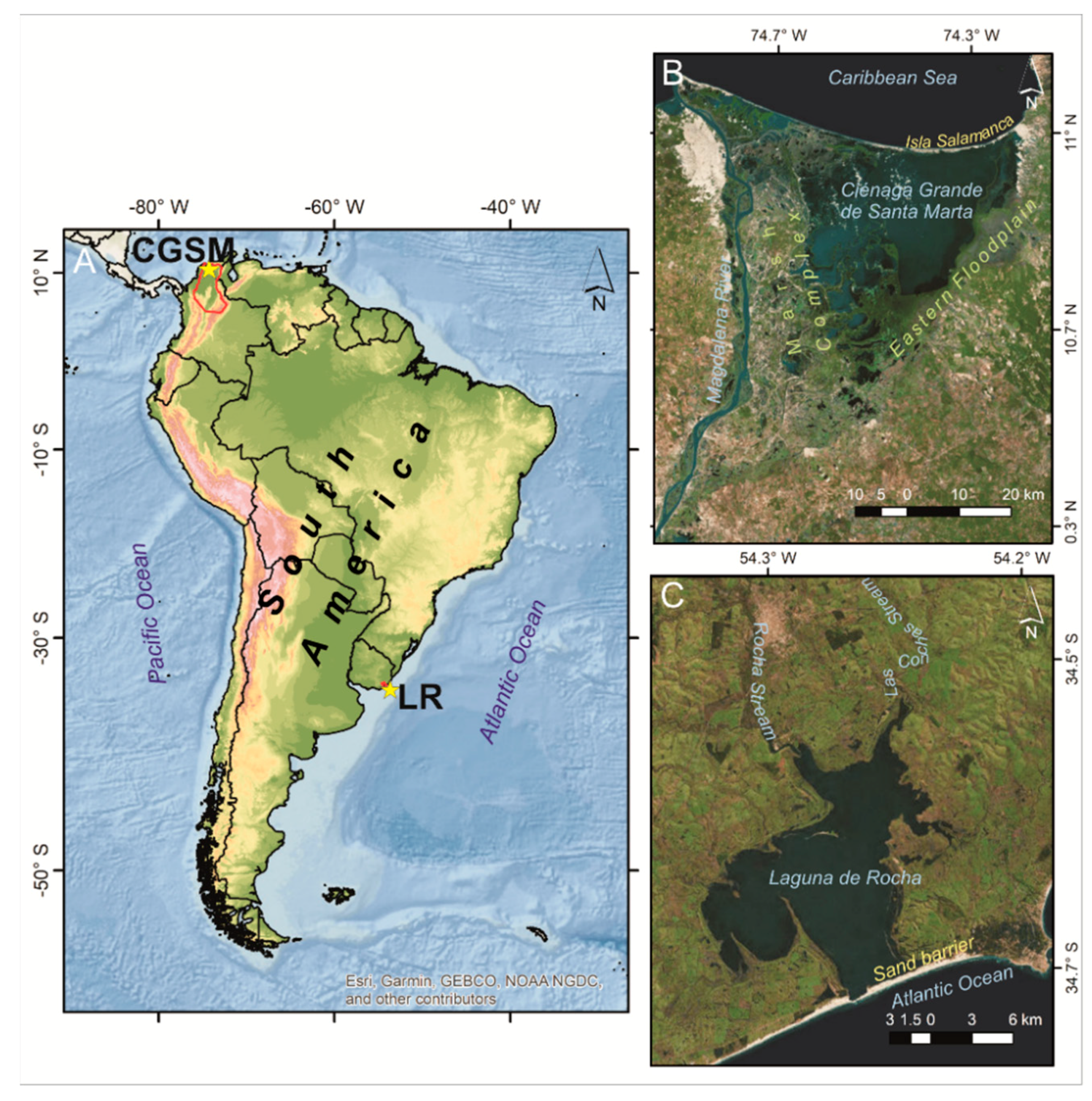
The second component of the EBRM process is risk assessment, which is divided into three steps: Risk identification, analysis, and evaluation (Figure 1). In the risk identification step, the ecological vulnerabilities of significant ecosystems, ES, and the main pressures from principal drivers are identified in light of the desired outcomes (identified earlier in the management context). Based on an environmental cause-effect pathways analysis [8], and in consultation with stakeholders, this step helps identify the ecosystem susceptibilities to the pressures of concern (i.e., environmental effects). Thus, the key output of this step is an environmental vulnerability profile that sets the priorities for the subsequent risk analysis step (see [8]). The risk analysis step involves estimating the likelihood of environmental effects and their impacts on the previously defined management outcomes, as well as the existing risk management measures and controls [11]. The output of this step is an environmental risk profile, which is the basis for informing management decisions in the risk evaluation step. In the risk evaluation, the competent authorities and all the stakeholders decide if no measures are needed (risk acceptance), if existing measures are adequate (risk tolerance), or if new measures are required (risk aversion). Only in the risk aversion case does the risk management process extend to the risk treatment, the third and final component in the EBRM, where paleoenvironmental information is less likely to contribute (Figure 1).
Paleoenvironmental data can play a major role in risk assessment. This role extends well beyond simply providing context as paleoenvironmental data have the capacity to reveal historical ranges of ecosystem variation, pre- and post-human influence, as well as the ecosystem’s responses to natural (e.g., climate) and anthropogenic pressures and any potential or real tipping points [13]. Most importantly, paleoenvironmental reconstructions help identify key master variable(s) that have controlled the ecosystem function in the past, and, thus, allow for an assessment of ecosystem resilience to past pressures. Paleoenvironmental information can also inform on several ecosystem components, such as the effect of eutrophication on the diversity of species in a lake [14], or the effect of long-term agriculture on a lake’s productivity and fisheries [15]; limited only by the variety and success of possible past reconstructions—not only of the ecosystem but also of its ES. Therefore, paleolimnological, paleoecological, and paleoenvironmental information can be used to illustrate possible scenarios of ecosystem change given the different management alternatives [5], and potentially generate predictions that could be used to inform outcomes of the EBRM process. The fate of the ecosystem and its services can be better assessed and ideally predicted if the long-term behavior of ecosystem function is incorporated. This information can be useful to categorize the magnitude of consequences (e.g., risk matrix), and, thus, help define the environmental risk profile.

3. Case Study Sites

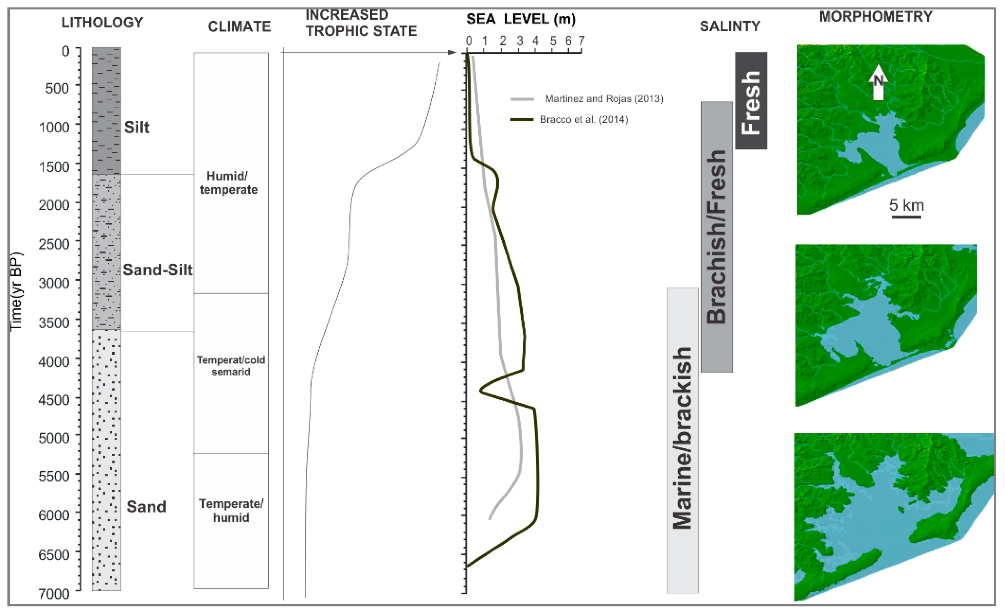
3.1. Laguna de Rocha (LR)

Laguna de Rocha (LR) is the second largest coastal lagoon in Uruguay with a surface area of 72 km2 and a basin of about 1250 km2 inhabited by 40,000 people (Figure 2). Land use includes extensive cattle ranching, forestry, artificial prairies, and agriculture. Tourism has progressively increased in areas close to the sand barrier and towns in the watershed (including the county’s capital city). The main pressures on the lagoon include eutrophication, coastal erosion, and alteration of the natural hydrology. Because areas adjacent to LR are prone to flooding, the sand barrier is often opened artificially to reduce flooding of grasslands used for livestock grazing, and also to allow the entry of shrimp larvae for harvesting by artisanal shrimp fishermen. Climate variability has also impacted the lagoon, via changes in sea level, rainfall, and wind patterns [16] that affect not only the salinity and the associated ES, but also the biodiversity.
Human occupation dates back to 3000 Before Present (BP), whereas modern fishermen settled the area during the first half of the past century, mainly along the tributaries and on the sand barrier [17]. After 1950, fishing communities on the sand barrier were established, and housing and tourism developed, mostly on the southern area of the system close to the ocean [18,19,20].

3.1.1. Recent Conditions at LR

LR is a natural area protected by international agreements (e.g., UNESCO Man and Biosphere Program, and Ramsar Convention on Wetlands -RAMSAR-), and in 2011 it was inducted as a Protected Landscape into the National System of Protected Areas (SNAP). LR is presently co-managed by Rocha Provincial Government (IDR) and DINAMA (a national environmental authority). A local advisory committee (CAE) was formally established in 2012, composed of local and national authorities, landowners, farmers, and fishermen. Stakeholders have been actively cooperating since the 1990s on critical environmental issues, with a remarkable disposition towards building agreements for conservation and sustainability, particularly concerning the protection of the natural hydrology of the system and the sand barrier which is a known sensitive area. Among the relevant topics addressed by CAE is a recent effort among stakeholders and local and national authorities for an artificial breaching of the sand barrier [18]. The process of artificially connecting the lagoon to the Atlantic Ocean (AO) is of major significance since most ES depend on, or are influenced by, salinity concentration controlled by the balance ocean/freshwater.
During the development of the management plan of LR Protected Area, relevant ecosystem services were identified by stakeholders and relevant authorities. The main ones include flood protection, water quality maintenance, landscape appreciation, and a complex set of ES facilitated by the sand barrier. The latter include all those processes occurring at the lagoon–ocean boundary that facilitate the natural sedimentological dynamics of the sand, needed for the maintenance of the sand barrier and its dunes. This ES has been formally listed as one of the key conservation objectives in the Management Plan of LR Protected Area. As with most ES from this lagoon, these services are closely connected to water dynamics. Therefore, understanding the past hydrological conditions, derived from paleolimnological reconstructions, would largely help to inform the context and more adequately forecast the risk of losing these ES.

3.1.2. Paleolimnological and Paleoenvironmental Reconstruction

Holocene sea level changes have played a major role in the formation and limnological evolution of LR [21]. During the early-mid Holocene, ~7000–4000 14C BP (uncalibrated dates), the lagoon was formed as a result of the marine transgression and maximum sea level. An important volume of sand was accumulated leading to the formation of the sand barrier. During this time, the lagoon reached its highest extension under temperate humid climates (Figure 3). A regressive phase followed the transgression, and lasted until ~2000 14C BP. At this time, sea level was ~2 m below modern sea level, and sand/silt sediments accumulated. The lagoon was reduced in size under temperate semiarid climates. During the last stage of the regressive phase (2000 14C BP), climates turned more humid whereas the lagoon reached its minimum extension. The influx of silt and sand continued reaching the lagoon [21].
Salinity in LR has varied as a function of the marine pulses. During the Holocene transgression, brackish/saline conditions prevailed, but during the regressive phase salinity decreased and brackish/freshwater conditions prevailed [21]. Nutrients have also been controlled by the marine pulse. During the Holocene transgression, the lagoon maintained relatively low trophic levels, whereas during regressive episodes, higher trophic states prevailed as a result of increased runoff bringing extra input of organic matter [21]. In general, an inverse relationship between trophic state and sea level (and paleosalinity levels) has been inferred for LR and for all the others coastal lagoons of the east coast of South America. Palynological studies have also indicated that salinity concentration determines the type of submerged and littoral vegetation growing in the lagoon [22,23]. In summary, paleolimnology illustrates that the Holocene transgression leads to a permanently open coastal lagoon (Figure 3), while the sea level regression leads to an intermittently semi-enclosed water body.

3.2. The Ciénaga Grande de Santa Marta Lagoon (CGSM)

The CGSM is the largest coastal lagoon in Colombia with a surface area of 450 km2 and a key site that provides direct subsistence for approximately 300,000 people (Figure 2). Hydrologically, the lagoon is naturally fed from the west by the largest river in Colombia, the Magdalena River, separated from the lagoon by a marsh complex. To the north, the lagoon is separated from the Caribbean ocean by a sand barrier called Isla Salamanca; on the east, the lagoon is fed by several rivers draining from the western slope of the Sierra Nevada de Santa Marta. The lagoon is currently suffering from a serious environmental crisis that has caused the loss of functions and subsequent ES [26].
Before colonial times, the lagoon offered key ES to indigenous populations that included fishing and salt extraction. During colonial times, ES expanded to agriculture and ranching, and later on, from the end of the 1800s until mid-1900s, ES further supported banana plantations as a result of the banana boom [26]. The first environmental crisis occurred from 1956 to 1980 when the lagoon was cut from the Caribbean by the construction of a highway on the sand barrier. During this time, eutrophication led to the loss of biodiversity and key services like fishing [26]. Because of this crisis, and in an attempt to protect the lagoon, in the 60s and 70s, the government of Colombia declared Isla Salamanca a national park, and several areas of mangrove forests and marsh complexes immediate to the lagoon, as natural reserves. In spite of efforts to restore the lagoon, it continued in a poor state, affecting the livelihoods of its residents.

3.2.1. Recent Conditions at CGSM

In the late 1990s and 2000s, an international consortium between Germany and Colombia created Prociénaga [27] an international project aimed to improve the ecological conditions of the lagoon by reconnecting it to some of its natural hydrological flows and by proposing it as a RAMSAR site. Unfortunately, during this time, the internal conflict and political instability of the country prevented the government from following completely the directions suggested by Prociénaga, precluding the full recovery of the ecosystem and its services. However, a temporary connection of the lagoon with a few freshwater flows improved the conditions in the lagoon for a few years. In 2014, as a result of a strong El Niño and the building of a road parallel to the Magdalena River that further isolated it hydrologically from the river pulse, the ecosystem was pushed to its worst state in which hyper-eutrophy, anoxia, and hypersalinity caused a mass mortality of mangrove and fish [10,28]. These conditions have had a tremendous impact on the ES and, therefore, on the inhabitants of the lagoon. ES have been classified as provisioning (food, water, forest resources, etc.), cultural (educational, recreational, and local identity) and regulating (climate and hydrological regulation, nursery, etc.) [29].

3.2.2. Paleolimnological and Paleoenvironmental Reconstruction

A paleoenvironmental study based on diatoms and lithostratigraphy on a core extracted on the eastern margin of the lagoon (Figure 4) [30] and a palynological study [31] indicate that the CGSM was formed about 5000 years ago (BP) as a result of a mid-Holocene marine transgression and local tectonism that flooded a freshwater marsh colonized by dry forest and grasses. As the marine transgression progressed, after ~4000 BP, the ecosystem turned into a brackish environment which favored the expansion of mangrove forests at the expense of the original dry forest, and, by ~2000 BP, brackish conditions but with more marine influence were established. A distinctive period of higher salinity was identified from 2200 to 1900 BP; during this period, the composition of the mangrove forest changed to a more saline-tolerant one. In the last ~2000 BP, several short-lived periods of fresher water conditions have occurred.

4. Incorporation of Paleoenvironmental Data in the EBRM Protocol in LR

Using the two case studies, we illustrate below how the existing paleoenvironmental data is being used in LR and how it could be used in the CGSM to inform the risk assessment process. By supplying unique, concrete examples we hope to highlight the utility and advantages of introducing this type of historical data into a risk management framework (Table 1).

4.1. Establishing the Context

A fundamental and necessary management outcome (Table 1) for LR is the maintenance of the opening and closing of the sand barrier to guarantee a natural intermittent connection between the lagoon and the AO (i.e., salinity alternation, natural exchange of fish and invertebrates, sediments, pollutants, etc.). As indicated by the paleolimnological information, sea level dynamics have controlled salinity and nutrient concentration in the lagoon [21,23], which are key variables for ecosystem functioning and services today.
In terms of the ecological unit (Table 1), paleolimnological information illustrated different scenarios of sea level change and, more importantly, the intricate historical relation between AO and LR. From the paleolimnological reconstructions, we inferred that, with a ~5 m sea level increase, the lagoon would be transformed into an estuary (Figure 3), while with a ~2 m sea level decrease above present sea level, it would lead to a semi-enclosed water body. Thus, based on paleolimnological data it seems necessary to enlarge the ecological unit to include the coastal zone and the open marine waters contiguous to LR.
Paleolimnological information from LR significantly contributes to the definition of risk criteria (Table 1—i.e., to evaluate the future consequences of current pressures) by contextualizing how LR has responded in the past to different pressures (sea level variation, climate variability, and anthropogenic activities). Given that the maintenance of the natural intermittent connection between LR and AO has been identified as a primary management outcome, the paleolimnological information is key in identifying the natural dynamics of this connection. As shown by past reconstructed scenarios, when there is no barrier (in case of a marine transgression), the trophic state is reduced and salinity increased [21], with significant negative consequences for ES. As a result, maintaining an optimal balance between AO and LR became one of the main risks identified in the assessment process.
The data/information needs step (Table 1) was informed by paleoenvironmental studies that helped identify the principal sources of energy and their variation through time. In doing so, it also showed the need to know more about the sources of the organic matter, produced both, inside and outside the lagoon, so additional paleoenvironmental reconstructions using stable isotopes are needed [32]. This information will allow inferring the energy fluxes between the sea, the lagoon, and the watershed, and their associated ES. The latter approach has been successfully used in the Río de la Plata watershed [33,34].

4.2. Risk Assessment

In the risk identification step (Table 1), paleolimnological data has been useful in the identification of key variables controlling the ecosystem. Based on the ecosystems and services susceptibilities, for LR, paleolimnological data suggest that salinity and nutrient load (OM content) have been the main variables controlling the long-term natural functioning of the lagoon. The fossil records suggest that vegetation, nutrient levels, and microalgae assemblages change with salinity, which in turn is controlled by the connectivity between the AO and the LR, thus highlighting the critical role of the sand barrier [22,23].
This information can help identify quantifiable thresholds of salinity and nutrients, although it should not be forgotten that these would be established for the “paleoecosystems”. Such data are useful to help assess risk from the various pressures on the “master variables” (i.e., salinity and OM content). Presently, the main pressure loads in LR include: (a) Urbanization on the barrier, (b) artificial or unplanned opening of the barrier, and (c) excessive and uncontrolled load of nutrients from poorly managed wastewater (including agricultural water) systems in the watershed.
Urbanization (pressure a) on the barrier would reduce its natural variability as it produces permanent and rigid structures in the barrier. This, in turn, implies the permanent isolation of the lagoon, similar to the state identified in the last 4000 14C BP, where the lowering of sea level caused a change from brackish to freshwater conditions, and an increase in its trophic state and water retention time. The unplanned or artificial opening of the barrier (pressure b) will generate significant changes to the natural cycles of salinity (seasonal precipitation), with consequences especially for the fauna. Finally, the effect of an increase in nutrient loading (pressure c) would have dramatic consequences for the ecosystem (and hence the provision of ES). Although there is no direct paleolimnological proxy for such a period in the LR environmental reconstruction, we know that large nutrient inputs have a dramatic effect on aquatic ecosystems [35]. Further, in El Diario Lagoon, a nearby watershed that belongs to the same coastal system as LR in SE Uruguay, extreme eutrophication occurred after 1955 due to the complete closure of the lagoon’s mouth by a scenic highway. The closing intensified freshwater flooding as incoming flow could no longer discharge into the estuary, and transformed the lagoon into a freshwater reservoir. The reservoir even served as a source of drinking water in 1967 and 1968, but later on, in the 1980s, it became hyper-eutrophic from urban expansion and sewage inputs that finally helped transform the lagoon into a wetland marsh [23]. Thus, the worst-case risk scenario includes having the two pressures a and c acting simultaneously; the associated consequences of which would almost surely be much more serious than the simple addition of both pressures (i.e., multiplicative rather than additive effects).
From the previous steps, it is clear that paleolimnological information helps to identify and contextualize the ecosystem’s vulnerability by showing historically the main pressures and their effect on the function and services of the ecosystem. The next step of risk formulation will make use of this cross-cutting information to produce the environmental vulnerability profile, which will be a basis for establishing and prioritizing remedial options during the risk analysis. This is the step in the EBRM process that LR currently occupies and will be formally undertaken by the administration board of the protected area, informed by the local governance advisory group (CAE) incorporating both paleolimnological and long-term monitoring data.
As the main output of the risk analysis step, the environmental risk profile (Table 1) prioritizes spatial and temporal areas of highest risk, based on the likelihood and magnitude of environmental effects, their impacts to the ecosystem (and, therefore, to ESs), and the analysis of existing management actions. In LR, paleolimnological information will be relevant in the analysis of impacts and in the improvement of stakeholders risk perception within the CAE and its management proposals. In this sense, and directly focused on the reduction of negative consequences of one the main pressures identified (i.e., artificial or unplanned opening of the sand barrier), stakeholders in LR have been collectively coordinating actions towards a management plan, which includes a protocol for the sustainable opening of the lagoon’s sand barrier. Paleolimnological information will be then directly and indirectly contributing to support improved environmental governance in LR.

5. Incorporation of Paleoenvironmental Data in the EBRM Protocol in the CGSM

5.1. Establishing the Context

The desired management outcome (Table 1) for the CGSM would be the recovery of ecosystem functions and, thus, the ecosystem’s ES. In order to achieve this, it is necessary to re-establish the natural hydrological connectivity of the lagoon with the ocean and freshwater flows. With the reactivation of these flows, the current hyper-saline, hyper-eutrophic, and anoxic state can be gradually alleviated. In fact, a partial opening of a few canals a few years ago, resulting from suggestions of the Prociénaga project, reduced salinity levels temporarily [27]. The paleolimnological study has indicated that since ca. 4000 BP the lagoon has maintained brackish conditions due to a dynamic and balanced exchange between freshwater and marine pulses, and that, at least at a centennial scale, neither hyper-salinity, hyper-eutrophic conditions, nor anoxia have occurred (Figure 2).
In terms of the ecological unit (Table 1), the paleolimnological and paleoecological studies [30,31] can help to elucidate that, throughout its history, the ecosystem’s function has been dependent of a dynamic input between marine and freshwater influx of waters, nutrients, and sediments. The geomorphology of the area indicates that the lagoon and its marsh complex on the west are all part of the floodplain of the Magdalena River and that, on the east, the lagoon is part of the floodplain of the rivers coming from the Sierra Nevada [36]. Paleolimnological studies, thus, confirm that the influx of marine and fresh waters, along with their sedimentological loads is essential for the function of the lagoon, and that they must be considered in terms of hydrologic boundaries. Therefore, based on past environmental reconstructions, it seems necessary to define the ecological unit including the upper basin of the Magdalena River (this river collects particles, including heavy metals and other pollutants, from the entire country and brings important sediment loads into the CGSM [26,36,37]) and the marsh complex; the littoral part of Caribbean, particularly the sand barrier [38], where dynamic sedimentological and erosive processes have been taking place, and the tributaries coming from the western slope of the Sierra Nevada de Santa Marta.
For the definition of the risk criteria (Table 1), paleolimnological information has illustrated that brackish and oxygenated conditions have been long-term natural conditions of the ecosystem, and, superimposed, there have been modest centennial scale changes towards either more saline or fresher conditions. This is all a testimony of the dynamic and historical hydrological connection. Past pressures include changes in sea level (eustatic and or tectonic), marine input, and precipitation. Paleoenvironmental reconstructions have shown that for 4000 years the ecosystem thrived under an alternating regime of freshwater and marine conditions with temporal changes in salinity that have not compromised the function of the ecosystem. These shifts, most likely resulting from natural climate variability and geomorphological processes (e.g., the formation of Salamanca Island), constitute known states, and natural ranges of variability of the ecosystem. In other words, the ecosystem appears to have the resilience to bounce back for periods of higher or lower precipitation, marine connectivity, etc., without obvious impartment of function (i.e., no evident hypersaline conditions at centennial scale as indicated by the diatom record). This information suggests that, in order to restore the functions of the ecosystem (desired outcomes), it is critical to restoring the flow of natural marine and freshwater inputs to ensure brackish conditions, which is the desirable and acceptable state to maintain. From this baseline condition, the ecosystem has had the capability to bounce back from either a more saline state or fresher state.
In the step of data/information needs (Table 1), more paleolimnological and paleoecological studies are necessary to understand better the energy fluxes, and the hydrological and sedimentological dynamics of the lagoon. The nutrient and sediment loads coming from the ocean and the Magdalena River, and the rivers on the east, and the distribution of the sediment within the lagoon are still poorly understood. Sediments feeding the barrier come mainly from the ocean but it has been suspected that sediments brought by the Magdalena River and eastern rivers also have an important contribution in maintaining the integrity of the bar. There is also the need to know if the periods of fresher water conditions are produced by direct precipitation, and or through input from the Magdalena River; in which case, the role of the marsh complex in the west would be far more important for consideration when establishing the context of the risk assessment as this is an important area in the control of the sediment loads reaching the lagoon. Paleoenvironmental reconstructions with higher temporal resolution are also needed for the identification of shorter-scale pressures and ecosystem responses (i.e., the effects of past El Niño/La Niña events).

5.2. Risk Assessment

Based on the CGSM ecosystem and the potential pressures impacting its focal ES, paleolimnological data suggest that salinity, resulting from the hydrological connectivity (lagoon–ocean–rivers) has been the main control over the healthy functioning of the lagoon. The health of the ecosystem has always relied on the hydrological connectivity established by the geomorphological setting that includes the floodplain of the Magdalena River, the sand barrier, and the smaller floodplain to the east. From a risk identification perspective, this connectivity maintains the baseline conditions that include brackish and oxygenated waters, with a balanced input/output of nutrients and sediments. At present, the main pressures include (a) a decrease in the marine pulse (including its nutrient and sediment load) due to the construction of a highway on the sand barrier; (b) a decrease in the freshwater flows coming from the Magdalena River due to the construction of a road parallel to the river and water capture for agroindustry; (c) excessive and uncontrolled inputs of nutrients and pollutants brought by the Magdalena River (from agroindustry, domestic waste from local residents, and extra organic matter sourced from the dying mangrove forest (the latter has lowered the oxygen levels in the water); (d) overexploitation of resources due to a growing local population; and (e) erosion of the sand barrier. Here, paleolimnology would inform the process by indicating that the lagoon is indeed more resilient, (e.g., returns to baseline conditions despite changes in precipitation and sea level) when brackish, oxygenated conditions are maintained due to a dynamic hydrological connectivity. Although this past resilience has undoubtedly been reduced due to increasing anthropogenic impacts, these flows remain a critical feature of the system that is currently at risk.
In the case of the CGSM, the risk formulation and visioning of future scenarios might seem less important since a threshold has likely been crossed [9], but the demonstrated resilience of the system offers some hope for renewal and the paleolimnological data can help us envision sustainable development options that incorporate variability between both brackish and freshwater future conditions. The paleoecological and paleolimnological reconstructions also help demonstrate that the vulnerability of the lagoon is directly linked to its ecological structure that is dependent on this connectivity. Once this structure is lost, the chain of effects is difficult to stop, the death of mangrove forest and the subsequent death of fauna and flora has led to a loss of both diversity and water quality. Remediation efforts that could first re-establish the necessary connectivity and then recreate critical habitats via simple re-plantings and re-introductions offer hope for success. Otherwise, the CGSM can only be used as a textbook example of things “not to do” when managing aquatic ecosystems.

6. Concluding Remarks

Once a risk management plan has been finalized and implemented (risk treatment), paleoenvironmental information may be an alternative for monitoring environmental events and the effectiveness of measures implemented to reduce risk [8]. In this sense, “modern sediment records” (e.g., highly-resolved cores) could generate monitoring data that would at least be comparable to the paleoenvironmental information that was incorporated into the risk assessment process. Depending on the nature of the ES being considered, paleoenvironmental data might also offer a very cost-effective strategy to use for monitoring itself (e.g., monitoring sediment accumulation once after five or ten years following a management action to assay algal production). Monitoring and review provide feedback to regulators, stakeholders, and the public, that informs their risk perception and the agreed-upon management strategies, as well as the basis for future adaptive management strategies [8].
Despite the value that paleoenvironmental reconstructions offer to the discipline of risk assessment, there are limitations stemming mainly from the resolution of the archive. For instance, tree rings, corals, and varved sediments offer reconstructions on an annual resolution, whereas other records such as sediments accumulated in lakes and oceans, generally offer decadal, centennial, or millennial scale resolution. Another limitation is related to the cost of some analyses; in particular, dating the archives is costly; however, without a robust chronological model, inferences of time are limited or erroneous and pitfalls may arise.
In Table 1 we have summarized the value added to the risk analysis framework if paleoenvironmental data is incorporated in each of the two critical components of the EBRM protocol: Establishing the context and risk assessment. We show how paleoenvironmental studies provide a robust context to risk management by documenting the long-term history of the ecosystem and by illustrating past scenarios of change that can serve as analogs of future changes. We show how, in LR, paleoenvironmental reconstructions have helped in the evaluation of risk in the EBRM protocol while, in CGSM, how it would potentially benefit any management plan. Paleoenvironmental data in both cases show that for thousands of years the resilience and capacity of the lagoons to bounce between different states without compromising the ecosystem’s health, depended on a dynamic natural hydrological connectivity (between the ocean and freshwater tributaries). Maintaining this connectivity should be a priority management outcome. Paleoenvironmental data helped to identify past pressures on the ecosystems that included changes in salinity and nutrients imposed by changes in sea level, climate, and the opening and closing of the sand barrier. In LR in particular, paleoenvironmental data helped model possible scenarios of ecosystem change given the forecasted sea level rise. In summary, paleoecological, paleolimnological, and paleoenvironmental data offers indirect information on past ecological scenarios that can be used as reference to anticipate future ecological responses.

Author Contributions

This article is a collaborative effort and the product of several meetings of the project “Sensing America’s Freshwater Ecosystem’s Risk to Climate Change” SAFER. PI: G.M.E.P.; Co-PIs: M.I.V., D.C., J.A.R., T.H., and J.E. and SAFER student C.S., contributed with analyses, writing, and editing. Researchers J.P.L., F.G.-R. helped in the conceptualization and supply and analysis of data from the LR lagoon. S.P.V. helped with data supply from the CGSM lagoon.

Funding

This research was funded by a grant from the Inter-American Institute for Global Change Research (IAI) CRN3038, supported by the US National Science Foundation (grantGEO-1128040), and by a grant from the U.S. National Science Foundation (Award CBET #1336839).

Acknowledgments

SAFER staff Andrea Huamantico Cisneros, Paula Costilla, and Paula Zapperi are thanked for their support in planning all SAFER meetings. We also thank SAFER PI and Co-PIs and adjunct researchers that host the meetings where this article was developed: Harmon, T. (Yosemite), Perillo, G.M. and Piccolo, C., (Bahia Blanca) and Chandra, S. (Guatemala). We are very grateful to Zilio, M., Schmidt, R. Wemple, B. and Pincetl, S. for stimulating discussions on the contribution of paleoenvironmental data in ecosystem management.

Conflicts of Interest

The authors declare no conflict of interest. The funders had no role in the design of the study; in the collection, analyses, or interpretation of data; in the writing of the manuscript, and in the decision to publish the results.

References

  1. Ekblom, A. Livelihood Security, Vulnerability and Resilience: A Historical Analysis of Chibuene, Southern Mozambique. Ambio 2012, 41, 479–489. [Google Scholar] [CrossRef] [PubMed] [Green Version]
  2. Wang, R.; Dearing, J.; Langdon, P.; Zhang, E.; Yang, X.; Dakos, V.; Scheffer, M. Flickering gives early warning signals of a critical transition to a eutrophic lake state. Nature 2012, 492, 419–422. [Google Scholar] [CrossRef] [PubMed]
  3. Randsalu-Wendrup, L.; Conley, D.J.; Carstensen, J.; Hansson, L.A.; Brönmark, C.; Fritz, S.C.; Choudhary, P.; Routh, J.; Hammarlund, D. Combining limnology and palaeolimnology to investigate recent regime shifts in a shallow, eutrophic lake. J. Paleolimnol. 2014, 51, 437–448. [Google Scholar] [CrossRef] [Green Version]
  4. Kong, X.; He, Q.; Yang, B.; He, W.; Xu, F.; Janssen, A.B.; Kuiper, J.J.; van Gerven, L.P.; Qin, N.; Jiang, Y.; et al. Hydrological regulation drives regime shifts: Evidence from paleolimnology and ecosystem modeling of a large shallow Chinese lake. Glob. Chang. Boil. 2017, 23, 737–754. [Google Scholar] [CrossRef] [PubMed]
  5. Conedera, M.; Colombaroli, D.; Tinner, W.; Krebs, P.; Whitlock, C. Insights about past forest dynamics as a tool for present and future forest management in Switzerland. For. Ecol. Manag. 2017, 388, 100–112. [Google Scholar] [CrossRef]
  6. Dearing, J.; Yang, X.; Dong, X.; Zhang, E.; Chen, X.; Langdon, P.; Zhang, K.; Zhang, W.; Dawson, T. Extending the timescale and range of ecosystem services through paleoenvironmental analyses, exemplified in the lower Yangtze basin. Proc. Natl. Acad. Sci. USA 2012, 109, E1111–E1120. [Google Scholar] [CrossRef] [PubMed] [Green Version]
  7. Barnosky, A.D.; Hadly, E.A.; Gonzalez, P.; Head, J.; Polly, P.D.; Lawing, A.M.; Eronen, J.T.; Ackerly, D.D.; Alex, K.; Biber, E.; et al. Merging paleobiology with conservation biology to guide the future of terrestrial ecosystems. Science 2017, 355, 6325. [Google Scholar] [CrossRef] [PubMed]
  8. Cormier, R.; Kannen, A.; Elliot, M.; Hall, P.; Davies, I. Marine and Coastal Ecosystem-Based Risk Management Handbook; ICES Cooperative Research Report; ICES: Copenhagen, Denmark, 2013; Volume 317, p. 60. ISBN 978-87-7482-115-1. [Google Scholar]
  9. Universidad del Magdalena; Ministerio de Ambiente y Desarrollo Sostenible. Los Diálogos de la Ciénaga Fase II: Construcción de Agendas, Ejercicio Para Activar la Participación y Construir una Visión de Futuro; Report; Universidad del Magdalena: Santa Marta, Colombia, 2018; 115p.
  10. Vilardy, S.; Luna, J.; Vidal, L.A.; Romero, I.; Marín, B.; González, S. Misión Académica ante Emergencia en Ciénaga Grande Abril 2016; Informe Técnico; Universidad del Magdalena: Santa Marta, Colombia, 2016. [Google Scholar]
  11. Cormier, R.J.; Savoie, F.; Godin, C.; Robichaud, G. Bowtie analysis of avoidance and mitigation measures within the legislative and policy context of the Fisheries Protection Program. Can. Manuscr. Rep. Fish. Aquat. Sci. 2016, 3093, 29. [Google Scholar]
  12. Dearing, J.A.; Acma, B.; Bub, S.; Chambers, F.M.; Chen, X.; Cooper, J.; Crook, D.; Dong, X.H.; Dotterweich, M.; Foster, T.H.; et al. Social-ecological systems in the Anthropocene: The need for integrating social and biophysical records at regional scales. Anthr. Rev. 2015, 1–27. [Google Scholar] [CrossRef] [Green Version]
  13. Bunting, L.; Leavitt, P.; Simpson, G.; Wissel, B.; Laird, K.; Cumming, B.; St. Amand, A.; Engstrom, D. Increased variability and sudden ecosystem state change in Lake Winnipeg, Canada, caused by 20th century agriculture. Limnol. Oceanogr. 2016, 61, 2090–2107. [Google Scholar] [CrossRef] [Green Version]
  14. Hobbs, W.; Ramstack, J.; La Francois, T.; Zimmer, K.; Theissen, K.; Edlund, M.; Michelutti, N.; Butler, M.; Hanson, M.; Carlson, T. 200-year perspective on alternative stable state theory and lake management from a biomanipulated shallow lake. Ecol. Appl. 2012, 22, 1483–1496. [Google Scholar] [CrossRef] [PubMed]
  15. Wengrat, S.; Padial, A.; Jeppensen, E.; Day, T.; Fontana, L.; Costa-Boddeker, S.; Bicudo, D. Paleolimnological records reveal biotic homogenization driven by eutrophication in tropical reservoirs. J. Paleolimnol. 2018, 60, 299–309. [Google Scholar] [CrossRef]
  16. Lozoya, J.P.; Conde, D.; Asmus, M.; Polette, M.; Píriz, C.; Martins, F.; de Álava, D.; Marenzi, R.; Nin, M.; Anello, L.; et al. Linking Social Perception and Risk Analysis to Assess Vulnerability of Coastal Socio-ecological Systems to Climate Change in Atlantic South America. In Handbook of Climate Change Adaptation; Springer-Verlag: Berlin/Heidelberg, Germany, 2015; p. 22. [Google Scholar] [CrossRef]
  17. Thompson, D. Economía e identidad de los pescadores de la Barra de la Laguna de Rocha. In Anuario de Antropología Social y Cultural; Romero Gorski, S., Ed.; Nordan Comunidad, Facultad de Humanidades y Ciencias de la Educación: Montevideo, Uruguay, 2008; p. 250. [Google Scholar]
  18. Rodríguez-Gallego, L.; Nin, M.; Suárez-Pirez, C.; Conde, D. Propuesta de Plan de Manejo del Paisaje Protegido LR.; Futuro Sustentable S.A.: Montevideo, Uruguay, 2013. [Google Scholar]
  19. Conde, D.; Vitancurt, J.; Rodríguez-Gallego, L.; de Álava, D.; Verrastro, N.; Chreties, C.; Solari, S.; Teixeira, L.; Lagos, X.; Piñeiro, G.; et al. Solutions for Sustainable Coastal Lagoon Management: From Conflict to the Implementation of a Consensual Decision Tree for Artificial Opening. In Coastal Zones. Solutions for the 21st Century; Baztan, J., Chouinard, O., Jorgensen, B., Tett, P., Vanderlinden, J.P., Vasseur, L., Eds.; Elsevier: Ámsterdam, The Netherlands, 2015; pp. 217–250. ISBN 978-0-12-802748-6. [Google Scholar]
  20. Nin, M.; Soutullo, A.; Rodríguez-Gallego, L.; Di Mini, E. Ecosystem services-based land planning for environmental impact avoidance. Ecosyst. Serv. 2016, 17, 172–184. [Google Scholar] [CrossRef]
  21. García-Rodríguez, F.; Metzeltin, D.; Sprechmann, P.; Trettin, R.; Stams, G.; Beltrán-Morales, L.F. Upper Pleistocene and Holocene paleosalinity and trophic state changes in relation to sea level variation in Rocha Lagoon, Southern Uruguay. J. Paleolimnol. 2004, 32, 117–134. [Google Scholar] [CrossRef]
  22. Mourelle, D.; Prieto, A.; Pérez, L.; García-Rodríguez, F.; Borel, M. Mid and late Holocene multiproxy analysis of environmental changes linked to sea-level fluctuation and climate variability of the Río de la Plata estuary. Palaeogeogr. Palaeocl. 2015, 421, 75–88. [Google Scholar] [CrossRef]
  23. Inda, H.; García-Rodríguez, F.; del Puerto, L.; Figeiras, R.; Stutz, S.; Mazzeo, N. Discriminating between natural and human induced shifts in a shallow coastal lagoon: A multidisciplinary approach. Anthropocene 2016, 16, 1–15. [Google Scholar] [CrossRef]
  24. Inda, H. Paleolimnología de Cuerpos de Agua Someros Del Sudeste del Uruguay: Evolución Holocénica e Impacto Humano. Master’s Thesis, Facultad de Ciencias Universidad de la República (UDELAR-PEDECIBA), Montevideo, Uruguay, 2009. [Google Scholar]
  25. Del Puerto, L.; García-Rodríguez, F.; Bracco, R.; Castiñeira, C.; Blasi, A.; Inda, H.; Mazzeo, N.; Rodríguez, A. Evolución Climática Holocénica para el Sudeste del Uruguay: Análisis multi-proxy en testigos de lagunas costeras. In El Holoceno en la Zona Costera del Uruguay; García-Rodríguez, F., Ed.; CSIC-UdelaR, Facultad de Ciencias: Montevideo, Uruguay, 2011; pp. 117–144. ISBN 978-9974-0-0757-4. [Google Scholar]
  26. Vilardy, S.; González, J.; Martín-López, B.; Montes, C. Relationships between hydrological regime and ecosystem services supply in a Caribbean coastal wetland: A social-ecological approach. Hydrol. Sci. J. 2011, 56, 1423–1435. [Google Scholar] [CrossRef]
  27. Salzwedel, H.; Barraza, L.; Montiel, R.; De la Cruz, T. La ciénaga Grande de Santa Marta desde la perspectiva de ProCiénaga. In Los retos Sociales y Ambientales de la Ciénaga Grande de Santa Marta. Foro público: Río Magdalena, Río de la Paz; Universidad del Magdalena: Santa Marta, Colombia, 2016. [Google Scholar]
  28. Rodriguez-Rodriguez, J.; Mancera, J.; Perdomo, L.; Rueda, M.; Ibarra-Gutierrez, P. Ciénaga Grande de Santa Marta: The largest lagoon-delta ecosystem in the Colombian Caribbean. In The Wetland Book; Finlayson, C.M., Milton, G.R., Prentice, R.C., Davidson, N.C., Eds.; Springer: Dordrecht, The Netherlands, 2016. [Google Scholar] [CrossRef]
  29. Vilardy, S.; González, J.A. Repensando la Ciénaga: Nuevas Miradas y Estrategias Para la Sostenibilidad en la Ciénaga Grande de Santa Marta; Universidad del Magdalena y Universidad Autónoma de Madrid: Santa Marta, Colombia, 2011; p. 228. ISBN 978-958-44-7849-8. [Google Scholar]
  30. Velez, M.; Escobar, J.; Brenner, M.; Rangel, O.; Betancur, A.; Jaramillo, A.; Curtis, J.; Moreno, J. Middle to late Holocene relative sea level rise along the Colombian Caribbean coast. Holocene 2014, 24, 898–907. [Google Scholar] [CrossRef]
  31. Van der Hammen, T.; Noldus, G.W. Paleoecología de la Ciénaga Grande de Santa Marta. In Studies on the Tropical Andean Ecosystems: La Sierra Nevada de Santa Marta (Colombia). Transecto Buritaca-La Cumbre; Van der Hammen, T., Ruiz, P.M., Eds.; J. Cramer: Stuttgart/Berlin, Germany, 1984; Volume 2, pp. 581–588. ISBN 978-3-443-65001-8. [Google Scholar]
  32. Lamb, A.L.; Wilson, G.P.; Leng, M.J. A review of coastal palaeoclimate and relative sea-level reconstructions using δ13C and C/N ratios in organic material. Earth-Sci. Rev. 2006, 75, 29–57. [Google Scholar] [CrossRef]
  33. Schindler, D.W. The dilemma of controlling cultural eutrophication of lakes. Proc. Biol. Sci. 2012, 279, 4322–4333. [Google Scholar] [CrossRef] [PubMed] [Green Version]
  34. Tudurí, A. Distribución y Tendencias Tróficas Actuales e Históricas de la Composición Isotópica de la Materia Orgánica Sedimentaria del Río de la Plata. Master’s Thesis, Facultad de Ciencias Universidad de la República (UDELAR-PEDECIBA), Montevideo, Uruguay, 2017. [Google Scholar]
  35. Bergamino, L.; Schuerch, M.; Tudurí, A.; Carretero, S.; García-Rodríguez, F. Linking patterns of freshwater discharge and sources of organic matter within the Río de la Plata estuary and adjacent marshes. Mar. Freshw. Res. 2017, 68, 1704–1715. [Google Scholar] [CrossRef]
  36. Bernal, G.; Betancour, J. Sedimentología de las lagunas costeras: Ciénaga Grande de Santa Marta y Ciénaga de Pajarales. Bol. Investig. Mar. Cost. 1996, 25, 49–76. [Google Scholar]
  37. Restrepo, J.D.; Kettnerb, A.J.; Syvitskib, J.P.M. Recent deforestation causes rapid increase in river sediment load in the Colombian Andes. Anthropocene 2015, 10, 13–28. [Google Scholar] [CrossRef]
  38. Gomez, J.F.; Byrne, M.L.; Hamilton, J.; Isla, F. Historical Coastal Evolution and Dune Vegetation in Isla Salamanca National Park, Colombia. J. Coast. Res. 2017, 33, 632–641. [Google Scholar] [CrossRef]
Figure 1. Risk management process for socio-ecological systems modified from [8]. The width of the blue arrow indicates the relative paleoenvironmental contribution in the EBRM. Blue arrows indicate where paleoenvironmental studies have more input; black arrows indicate a modest contribution from paleoenvironmental reconstructions.
Water 10 01350 g001
Figure 2. Location of the study sites and hydrological connections. (A) Location of the study sites circled in red in respect to South America. (B) The Ciénaga Grande de Santa Marta Lagoon in Colombia, the Caribbean, sand barrier (Isla de Salamanca) and the Magdalena River (see text for more detail). (C) La Rocha Lagoon in Uruguay, the Atlantic Ocean, sand barrier and main tributaries (see text for more detail).
Water 10 01350 g002
Figure 3. Holocene evolution of Laguna de Rocha (LR) in relation to sea level variation and climate. Note the Holocene increment in the trophic state in relation to salinity and sea level changes (morphometry taken from [24]; climate taken from [25]).
Water 10 01350 g003
Figure 4. Holocene paleoenvironmental reconstruction of the Ciénaga Grande de Santa Marta (CGSM) modified from [29]. Pollen-based vegetation reconstruction was based on [31], and relative changes in salinity and sea level were re-interpreted from [30].
Water 10 01350 g004
Table 1. Summary of the main contributions of paleo-data into the EBRM framework.
Main ComponentsStepsPaleo Value-Added Component
Establishing ContextManagement outcomesHistorical perspective on baseline conditions; it can illuminate the discussion on potential management outcomes.
Ecological unitRedefinition of the ecological unit by the identification of external or low frequency (e.g., millennial, centennial) pressures loads to the ecosystem (e.g., fluvial reactivation).
Risk criteriaInformation on key drivers or stressors controlling past changes in the ecosystem and ecosystem’s functions (e.g., salinity affecting primary producers and nutrient loads).
Information on the history of the ecosystem’s responses to diverse pressure loads.
Additional information in sites with the absence of historical data.
Information that can be used to improve stakeholder’s perception of risk.
Data and information needsInformation on current data gaps that can be answered by paleoenvironmental data needed to advance the risk management strategic planning (e.g., sediment distribution inside the lagoon and hence integrity of the sand bar).
Risk Assessment (Risk Identification)
-
Ecosystem components and services susceptibilities
-
Significant pressure loads
-
Environmental cause-effect pathways
Information on the resistance and resilience of the ecosystem, including: disturbance levels/intensity, periodicity, and potential thresholds of response, including multiple, potentially interacting, stressors (e.g., ecosystem adapted to marine regression and transgression, or climate variability).
-
Risk formulation (Environmental Vulnerability Profile)
Information on the most important stressors (priorities for stakeholders engagement), and illustration of possible future ecosystem scenarios.
Risk Assessment (Risk Analysis)Ecosystem components and Services impactsInformation on predictive models
Helps constrain key model driver variables (e.g., the sand bar as a long-term regulator of nutrients in LR), enhancing model calibration and validation.
Environmental Risk ProfileInformation to inform risk communication, enhancing stakeholder perception.

