Article

Optimizing Sediment Diversion Operations: Working Group Recommendations for Integrating Complex Ecological and Social Landscape Interactions

1
Environmental Defense Fund, Washington, DC 20009, USA
2
Louisiana State University, Baton Rouge, LA 70803, USA
3
Louisiana Universities Marine Consortium, Chauvin, LA 70344, USA
4
Department of Earth and Environmental Sciences, Tulane University, New Orleans, LA 70118, USA
5
University of New Orleans, New Orleans, LA 70148, USA
6
The Lowlander Center, Gray, LA 70359, USA
7
Department of Biological Sciences, Nicholls State University, Thibodaux, LA 70301, USA
8
Institute for Coastal and Water Research, University of Louisiana at Lafayette, Lafayette, LA 70504, USA
*
Author to whom correspondence should be addressed.
Water 2017, 9(6), 368; https://doi.org/10.3390/w9060368
Submission received: 11 April 2017 / Revised: 11 May 2017 / Accepted: 11 May 2017 / Published: 24 May 2017

Abstract

:
Future conditions of coastal Louisiana are highly uncertain due to the dynamic nature of deltas, climate change, tropical storms, and human reliance on natural resources and ecosystem services. Managing a system in which natural and socio-economic components are highly integrated is inherently difficult. Sediment diversions are a unique restoration tool that would reconnect the Mississippi River to its deltaic plain to build and sustain land. Diversions are innately adaptable as operations can be modified over time. An expert working group was formed to explore how various operational strategies may affect the complex interactions of coastal Louisiana’s ecological and social landscape and provide preliminary recommendations for further consideration and research. For example, initial operations should be gradually increased over 5 to 10 years to facilitate the development of a distributary channel network, reduce flood risk potential to communities, limit erosion of adjacent marshes and reduce stress to vegetation and fish and wildlife species. Diversions should operate over winter peaks to capture the highest sediment concentration, reduce vegetation loss while dormant, and reduce detrimental effects to fish and wildlife. Operations during the spring/summer should occur over shorter periods to capture the highest sediment load during the rising limb of the flood peak and minimize impacts to the ecosystem. Operational strategies should strive to build and sustain as much of the coastal landscape as possible while also balancing the ecosystem and community needs.

1. Introduction

Deltas are innately dynamic systems and climate change has added a layer of complexity to understanding future conditions of our world’s deltas [1,2]. The Mississippi River Delta (MRD) is one of the most heavily researched deltas in the world. Yet even with decades of intense science and data collection, anticipating and predicting ecological and social changes in the MRD is challenging both with and without human intervention. The State of Louisiana has proposed a US$50-billion effort to restore and protect the coastal landscape and communities [3,4,5] through the use of large-scale sediment diversions. Sediment diversions are designed to reconnect the Mississippi River to its floodplain, thereby transporting sediments from the Mississippi River to degrading wetlands, which will restart deltaic land building processes [6,7].
Historically, the Mississippi River entered into the Gulf of Mexico through a network of multiple distributary channels and sub-deltas spread throughout the southeastern and south-central coasts of Louisiana [8,9]. The influence of fresh water, sediment and nutrients was spread over a vast area of wetlands based on the natural rise and fall of the river, and the subsequent distribution and redistribution of sediment. The MRD landscape is thus about 25,000 km2 setting of bays, bayous, marshes and areas of open water. Levee construction along the lower Mississippi River and its distributaries following settlement and land clearing for agriculture was largely complete by the mid-nineteenth century [10,11]. However, a comprehensive federally managed system of levees from Cairo, Illinois to Venice, Louisiana was not begun until after the flood of 1927. In response to this devastating event, Congress authorized the Mississippi River and Tributaries (MR&T) Program to be constructed and managed by the U.S. Army Corps of Engineers (USACE). This action prevented breaching and overtopping that had previously occurred during flood events and ultimately impaired the natural flooding of the Mississippi River, severing the river from its floodplain [12]. Current levee management practices on the river have resulted in almost all of the land-building potential of the Mississippi River being concentrated in two outlets of the river, the Birdsfoot Delta and the Atchafalaya Delta complex, leading to a collapse of expansive deltaic wetland [13,14,15]. Between 1932 and 2010, Louisiana lost approximately 4900 square kilometers of land along the coast [16]. Without future human restorative interventions, the coast is predicted to lose an additional 5800 to over 10,000 km2 of land in the next 50 years depending on future uncertain environmental conditions affected by climate change, such as sea level rise [5].
The MRD does not function naturally as a result of management decisions impacting the river, the delta, and the regions subsurface that have created an artificial landscape dominated by a deteriorating delta [17,18,19]. Because of the human reliance on the current system, it is not feasible to return the system to a completely natural state. Sediment diversions are an engineering solution that can return some areas into a manmade replication of a natural state. Sediment diversions have been proposed as a foundational solution to the coastal land loss issue since the 1970s [4,20,21,22,23,24,25]. A diversion is a control structure of gates built into the levee of the Mississippi River that allows river water, sediment and nutrients to flow into degraded wetlands, mimicking the natural flood cycle, crevassing, and distributary sub-delta formation of the Mississippi River. Diversions are anticipated to provide significant benefits to the deltaic complex, including fish and wildlife that depend upon it and the estuarine complex it sustains. In turn, this would improve the overall health of the Gulf and forestall the gradual abandonment of areas of the coast to the Gulf of Mexico [7,20,26,27].
The State of Louisiana currently plans to begin constructing a large sediment diversion, the Mid-Barataria Sediment Diversion, by 2021. Once constructed and operational, the sediment diversion will quickly change the dynamics of the entire estuarine basin. Although there are modeling capabilities and scientific data to reasonably predict some of these changes, there are other aspects of the ecosystem and the communities that live and rely on the wetlands that are much more complex and harder to predict. Specifically, interactions among and between the various aspects of the ecological and social landscape currently, and in a future with climate change effects, are highly uncertain.
The inherent benefit of a controlled sediment diversion is that it is constructed with a series of gates that can be opened and closed based on riverine and basin conditions. Therefore, operational strategies become the most important component of predicting how the ecological and social landscape will change, allowing for adaptive management so that operational strategies can be modified in response to monitored future conditions. Operational strategies utilized in past modeling analyses have been simplified and standardized to provide consistency in the analysis, reduce computational costs and allow easy comparison between alterative human interventions [3,5]. The typical operational strategy is to operate the diversion anytime the Mississippi River flow is over approximately 17,000 cubic meters per second (m3/s), using either historical hydrographs or an averaged hydrograph over 50 years [3]. While providing consistency in the analysis, this standardized and simplified operation would likely result in large and unacceptable impacts to vegetation, wetland health, water levels, water quality and fish and wildlife species [28,29]. It is also unrealistic that this operation strategy would actually be put into practice.
As the State moves towards construction of a sediment diversion, the development of operational strategies will become an iterative process that will need to incorporate modeling analysis, monitoring and data collection, best professional judgement, adaptive management, and input from stakeholders, both those directly and indirectly affected by the diversion.

2. Materials and Methods

An interdisciplinary working group was formed to explore, discuss, debate and document these complex physical, ecological, economic and social issues related to operating a sediment diversion. Best professional judgement was utilized to begin to untangle the complexity of the interactions between the various aspects of the ecological and social landscape, specifically the interactions between water quality, habitats, fish and wildlife species, and natural resource users, both under current and future climatic conditions [30]. The Sediment Diversion Operations Expert Working Group (WG) was formed in September 2015 and consisted of 12 core members. Additionally, a total of 42 guest experts, invited by the core members, participated in a portion of each meeting to provide additional input and their recommendations on topics of relevance to their field of expertise. All of the experts involved have on-the-ground experience and an extensive understanding of the Louisiana coast and the Barataria Basin, the site of the proposed case study.
Between September 2015 and April 2016, the working group met monthly to discuss a specific topic(s) of importance to diversion operations (Table 1). The meetings included background presentations by core members, a facilitated discussion between guest experts and core members, and analysis and evaluation of recommendations by core members. With each topic, the team discussed the state of the knowledge, data gaps, triggers for modifying management actions, monitoring needs, and how the topic could be affected by various operation strategies. The process considered each of the key topics and their specific parameters as the only objective with no other constraints, to determine the optimal operation strategy that would maximize each parameter (e.g., what operational strategy would maximize land building if that was the only objective with no other constraints? What operational strategy would maximize shrimp production if that was the only objective?). After defining optimized operation strategies by each topic/parameter, the WG identified both consistencies and incongruities in the various strategies.
The Mid-Barataria Sediment Diversion was used as a case study. The Mid-Barataria Sediment Diversion is proposed on the west bank of the Mississippi River just north of Myrtle Grove, at river mile 60.7 (Figure 1). The diversion is proposed to have a peak flow of approximately 2100 m3/s, which is equivalent to the average annual flow of the Missouri River when flowing at full capacity [31]. The Mid-Barataria Sediment Diversion has a long history in restoration planning [3,23,27,32] and is slated to begin construction in 2021.

3. Results

3.1. Objectives of a Sediment Diversion

3.1.1. Land-Building Objective

Building and sustaining coastal land is the primary objective of a sediment diversion. Land-building is not a limiting or constraining factor to operation strategies. If land-building were the only objective, without any other constraints or considerations, the operation strategy would focus on opening the diversion as much as possible, nearly year-round to deliver the maximum quantity of sediment possible to the receiving basin (Figure 2). Modifications to discharges would occur to move sediment through the system, limit scour of existing wetlands and maximize vegetation health. Natural delta building processes are dynamic and disruptive to the current established estuarine condition. Operating a sediment diversion for only this objective maximizes land-building benefits that could be achieved, but would also result in substantial changes to other aspects of the environment, such as fish and wildlife species or vegetation.

3.1.2. Secondary Objective

Additional secondary objectives are needed to capture key aspects of the natural and socio-economic system to better define the scientific framework for the development of operational strategies. As with the primary objective, these secondary objectives should be specific and measurable. Secondary objectives can be considered the constraints on land-building, but provide balance to ensure a functioning and productive estuary. For instance, an objective could be developed to delineate specific habitat or estuarine gradients within the basin.

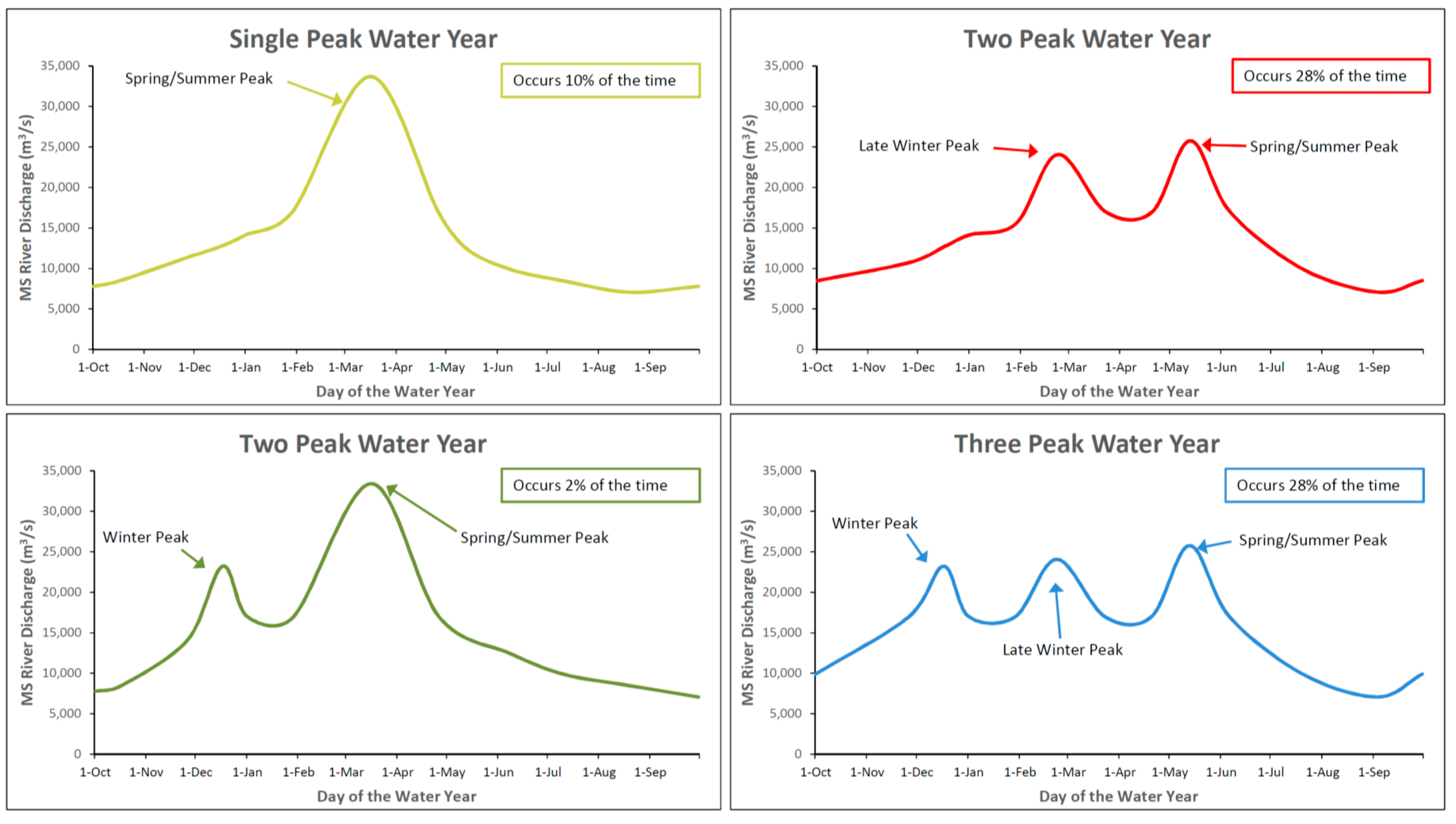
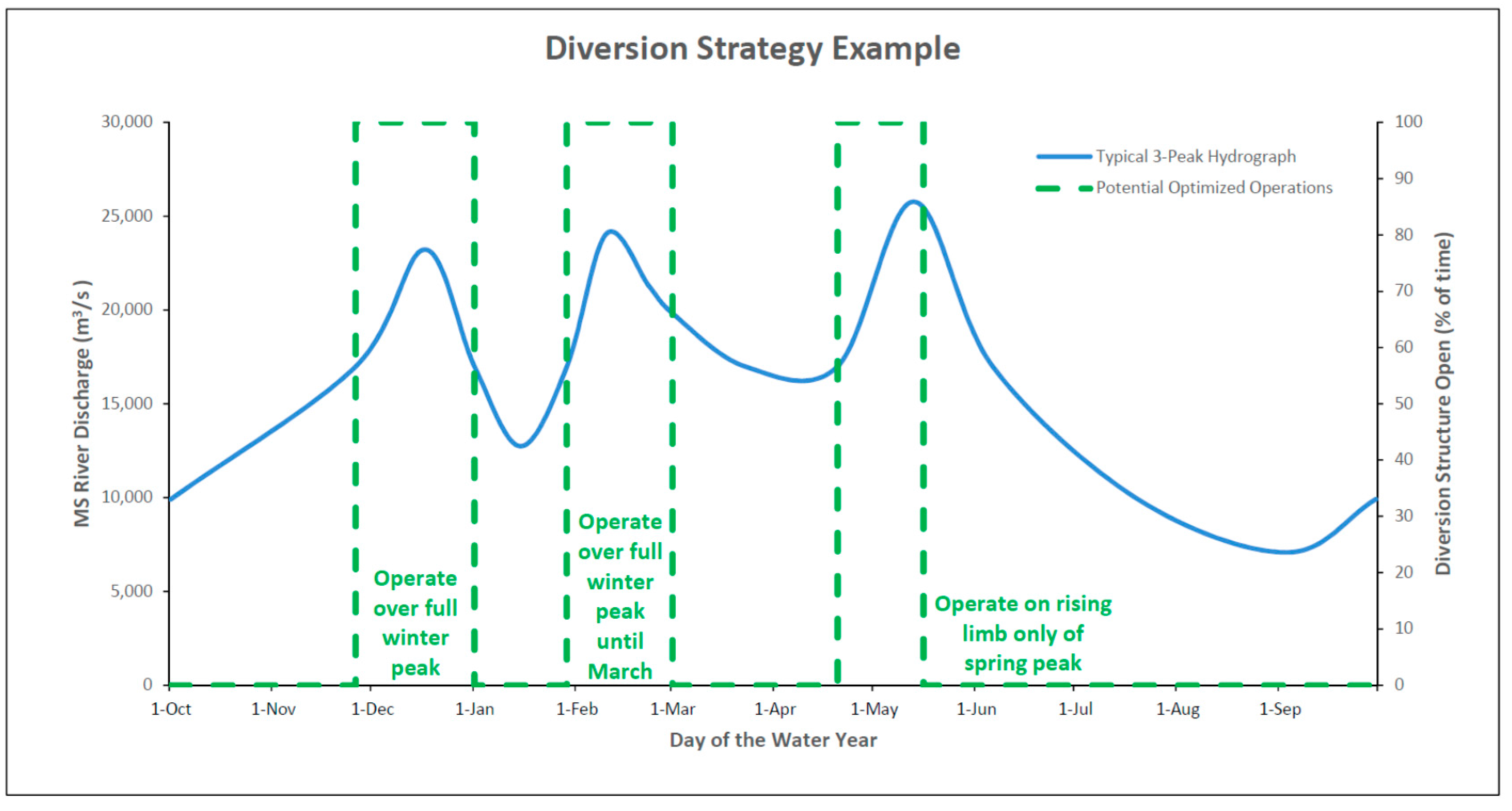
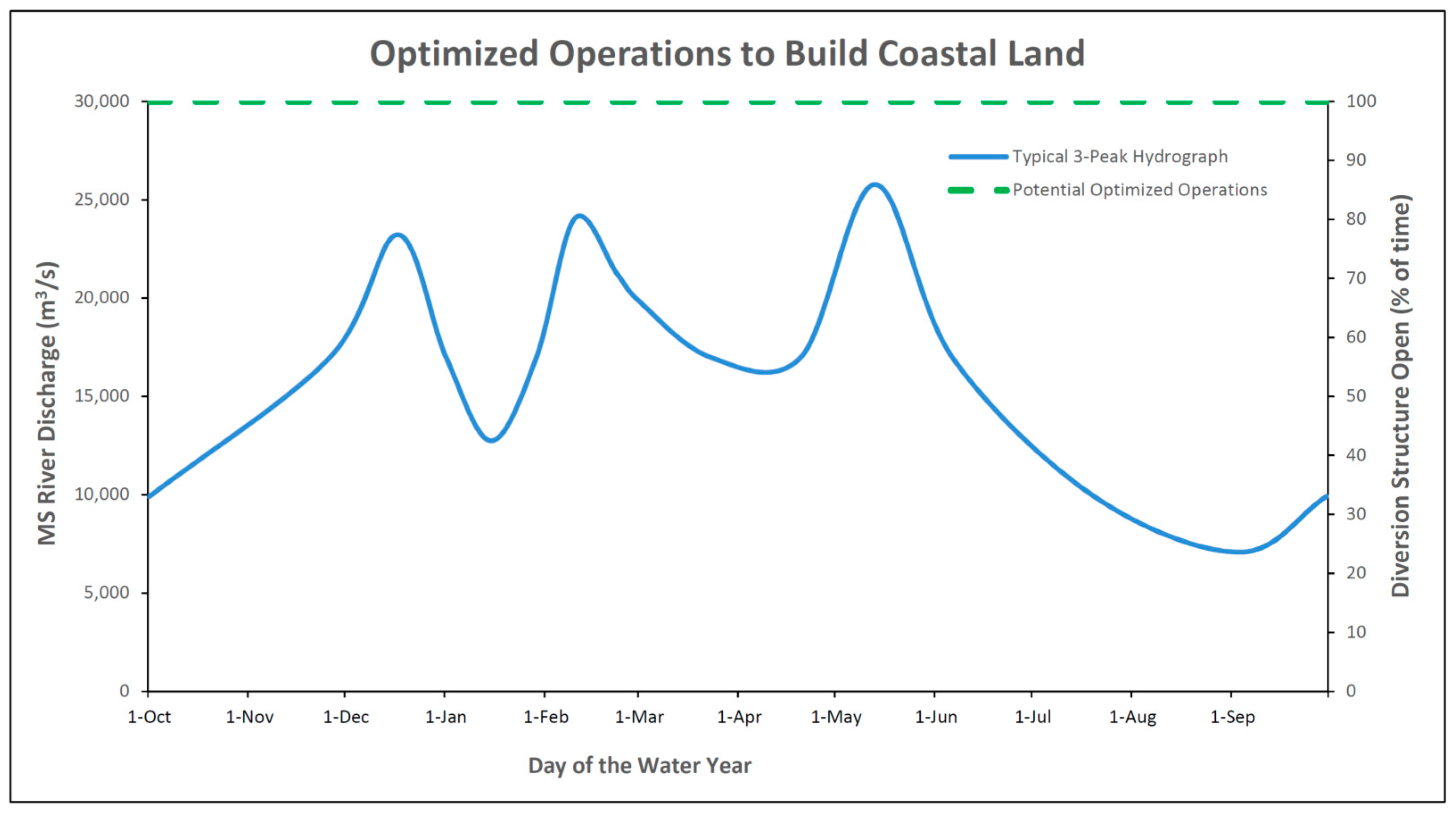
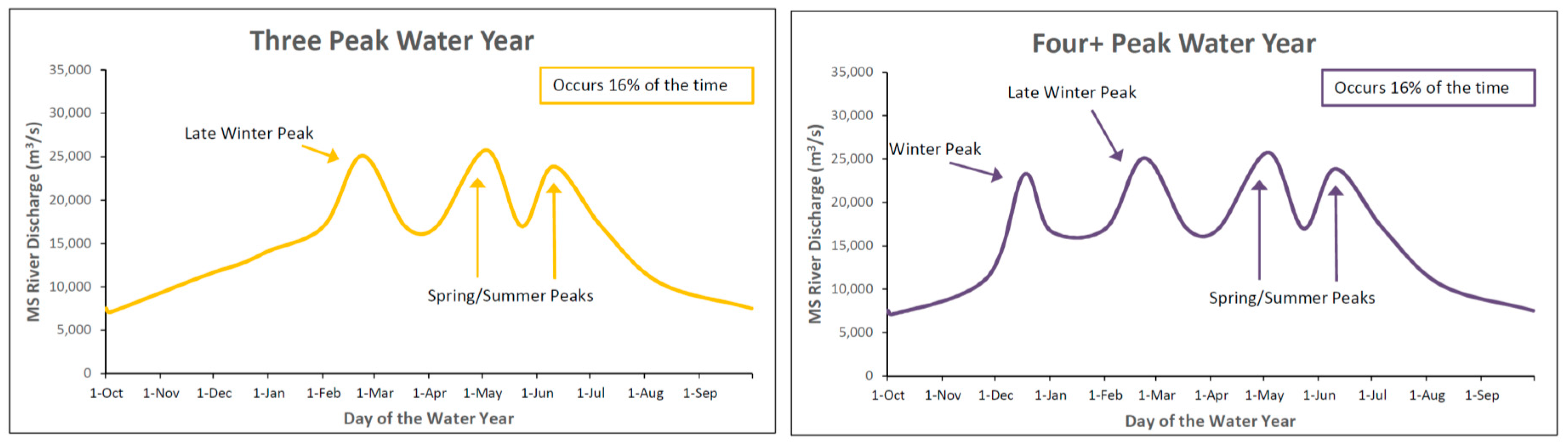
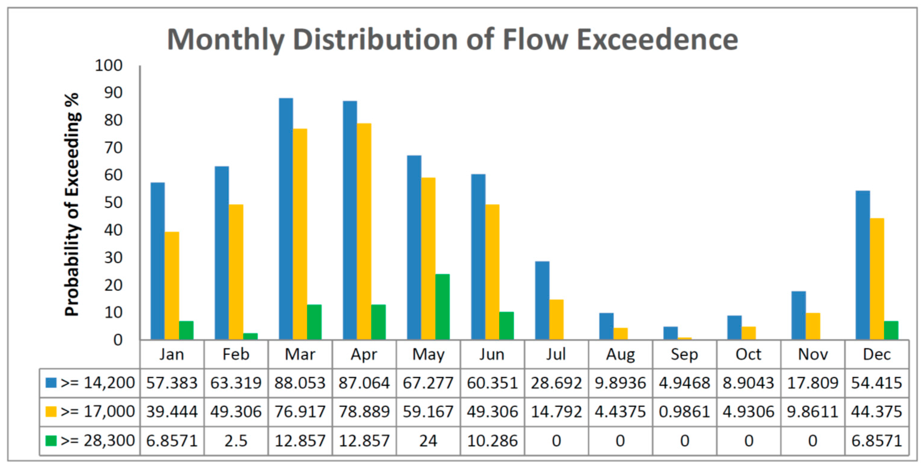
3.2. Hydrograph Typologies

Ongoing modeling analyses have utilized decades of historical hydrographs to predict future outcomes. Common methods include using some or all of the 56 year record and repeating those hydrograph years into the future, or averaging the historical record to develop a single composite hydrograph. The result of averaging the historical record is a theoretical hydrograph of the Mississippi River that is unlikely to ever occur. The impacts of current and future climate change on discharge patterns in the lower Mississippi River are worth examining. The historical records show no statistically significant trend of overall discharge in the Lower Mississippi River [33]. Outputs of climate models provide different predictions of discharge in the Mississippi River. Work by Tao et al. [34] indicates that there will be an increase in discharge in the basin during the 21st century, with an additional −100 to +450 km3·yr−1 of water flowing in the lower river. However, work by Nakaegawa et al [35] suggests that the magnitude of this change during the 21st century will be less, 88.4 km3·yr−1 (10.3% increase), with increased discharge during the spring floods and decreased during the late summer droughts. Fallon and Betts [36] predict that climate change in the 21st century could decrease discharge in the river by as much as 41.3 km3·yr−1, or increase by as much as 31.3 km3·yr−1. There is evidence in the literature that extreme events (both floods and droughts) are anticipated to increase and the timing of flood events may also shift [34,37]. The culmination of climate change effects across the entire Mississippi River watershed on the hydrograph remains uncertain. The operation of a sediment diversion can be adjusted to future discharge patterns in the river.
To counter the use of theoretical hydrographs, a statistical analysis was completed to determine if there were patterns in river flow over the past 56 years during the water year (defined as 1 October through 30 September of the next year). The discharge records from 1960 to 2016 from the USACE Tarbert Landing Station were used. This range was selected to avoid the lock and dam construction period that had largely ended by 1960. The record was filtered to identify peaks that exceeded 17,000 cms (600,000 cfs). Years with one, two, three and more than three peaks were put into corresponding classes respectively and the frequency of the occurrence of each class was determined. The mean date of occurrence and mean peak amplitude of each peak was computed, although this can vary in any given year based on rainfall and snowmelt over the entire Mississippi River watershed. The peak flows are based on the means over the 56 years and are subject to year-to-year variability of the order of ±15%.
Six basic hydrograph typologies were identified that could occur in any given year (Figure 3). Although the timing of peaks or frequency of occurrence are likely to shift in a future with climate change [34], the basic behavior of the river is likely to remain constant. These hydrograph typologies can be used to develop and communicate operational strategies, as operations are likely to differ in a one-peak river flow year compared to a four-peak river flow year.

3.3. Initial Operations

There are multiple geologic, hydrodynamic, ecologic and social concerns to be understood and considered when developing an initial operation plan. A sediment diversion should not be operated at full capacity on Day 1. Initial operational strategies (Years 0 to 10) should include gradual openings based on seasonality over the course of several years, allowing for the basin to adjust and evolve to accommodate the new flow conditions.

3.3.1. Geology and Hydrodynamics

Initial operational strategies should take into account the geology and hydrodynamics on the basin-side. The closest two existing analogs for sediment diversion in coastal Louisiana (West Bay Diversion and Wax Lake Outlet) both discharge into water bodies with depths that typically range from 1 to 3 m [39,40], whereas the Mid-Barataria Sediment Diversion will empty into an area consisting of broken, degraded marsh and shallow, open water before reaching Barataria Bay (2 m water depth) [41]. Wetlands in existing diversions and diversion analogue settings, such as the West Bay Mississippi River Diversion and the Cubit’s Gap Delta can accrete 1–5 cm of sediment during a seasonal flood pulse, enough to match or offset regional rates of relative sea-level rise in many locations [39,42]. Although the basin has an existing network of natural and man-made channels, it does not currently have the delta channels or distributary channel system to efficiently convey 2100 m3/s of water and sediment through the basin [40]. If water is not able to move through the basin to Barataria Bay and out to the Gulf of Mexico, water levels will increase on marsh surfaces and flood risk could increase for communities located proximal to the marsh complex (e.g., Grand Bayou, Lafitte) [43,44,45]. It is estimated that it could take 5 to 10 years for the distributary channel network to develop that would then allow the diversion to be operated at full capacity [43,46].
Sudden openings could create a surge in the distributaries which could endanger waterway users and cause excess scouring, and indeed many deltaic river mouths are erosional at the point where the channel enters the receiving basin [47,48]. Erosion of deteriorating marsh could occur in areas outside of the developing channel network, if river velocities are higher than 20–50 cm·s−1. Although most of the eroded sediments will be trapped somewhere further down basin, gradual operational strategies over the first 5 to 10 years should reduce unintended wetland loss from erosion. In addition, the loss of emergent land area reduces the capacity of the wetlands to capture and retain resuspended sediments during periods of inundation [3,5].

3.3.2. Habitats and Fish and Wildlife Species

The diversion will be flowing into already fragmented and degraded marshes where vegetation is already flood stressed [49,50]. This preexisting vegetation could die due to lack of time for adaptation to the new conditions or an increase in water levels which would then induce further wetland loss [50,51]. Likewise, fish and wildlife species can suffer from an initial shock of changing conditions. Initial operations should occur gradually to allow fish and wildlife species, as well as the habitats they depend on, to self-organize around the new normal conditions. In addition, vegetation stress and/or wetland loss could be reduced by focusing on operations during the non-growing (winter) season for at least the first 2 to 3 years.

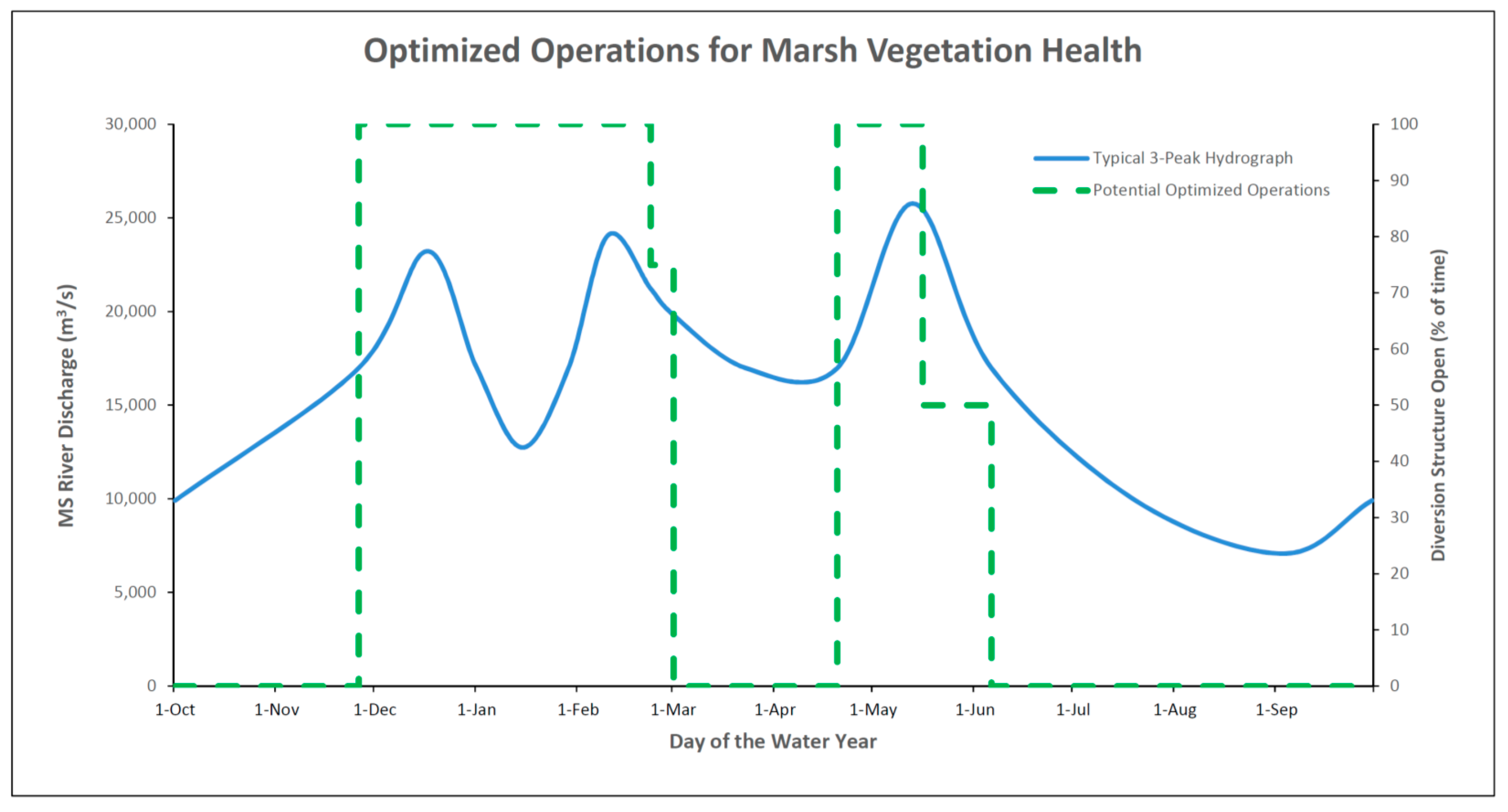
3.4. Winter Operations

3.4.1. Geology and Hydrodynamics

A commonly accepted operational strategy for sediment diversions is to mimic the natural function of the river and its floodplain. Operation strategies focus on using pulsed operations during the natural flood cycles of the Mississippi River, which typically occur from late winter to early summer, but could extend from early winter to late summer [52]. The Mississippi River can experience one or more flood peaks during the water year and those peaks often begin in the winter. Winter peak discharges are typically lower than in the spring, but can reach over 35,000 m3/s at New Orleans as occurred in January 2016. In the last 56 years (1960–2016), winter flood peaks (defined as over 17,000 m3/s from November through February) have occurred in 82% of the time (Figure 4) [38]. If the diversion’s operational threshold is lowered to 14,000 m3/s, the occurrence of annual winter peaks increases to 100% although some peaks are short-lived, being less than one week [38]. Standardized and simplified operation strategies use the 17,000 m3/s threshold as a point where sand resuspension potential increases and results in significant suspended sand loads in the water column [52]. Sand is an essential building block for new land, but silt and clay are essential in sustaining the existing wetland landscape, thus operational strategies should maintain flexibility to operate below the 17,000 m3/s threshold.
There are some clear advantages to operating a sediment diversion, both initially and over the long-term, on wintertime river peak flows. The sea surface elevation in the Gulf of Mexico is lowest in the winter, which can facilitate the movement of water out of the basin, thereby reducing residence times and the risk of elevated water levels for extended periods of time [53,54]. Additionally, the first peak of the water year tends to carry the greatest concentration of sand, silt and clay [55] and the highest suspended sediment concentrations occur from November through February, even though the highest sediment loads do not occur until March [38]. Suspended sediment is an essential component of sustaining existing marshes, both with sediment deposited directly on the marsh surface and sediment deposited on bay and canal bottoms that can be resuspended and deposited on the marsh surface during the passage of cold fronts [56,57,58,59,60]. To maximize sediment resuspension and transfer to the wetland surface, winter operations would take advantage of cold front passage (most prevalent from November to March) prior to the consolidation of the material on the bay bottoms. Operating a diversion in the winter and/or early spring enhances the chances of landward redistribution as approaching cold fronts bring onshore winds that generate waves and currents that increase coastal set-up and drive sediment landward and onto marsh surfaces [61].

3.4.2. Habitats and Fish and Wildlife Species

The exact vegetation response to operations of a diversion may be difficult to predict. There tends to be a lot of inertia in plant community dynamics and the dynamics of vegetation shifts are more complex [62]. There are examples in coastal Louisiana of vegetation being very responsive to fresh water inputs (Naomi Siphon) and others where vegetation has been very stagnant (Caernarvon Freshwater Diversion) [50]. Freshwater vegetation may establish in the outfall area over time, however maintaining as much intermediate and brackish marsh as possible will reduce the risk of episodic loss of freshwater vegetation that can occur from salinity spikes during droughts or tropical storm surge, and build wetlands that have resilience to rising sea levels and the subsequent increase in daily salinities [63]. Operations during winter months can minimize vegetation transition and reduce vegetation stress and loss from prolonged and continuous flooding while plants are in the dormant state (Figure 5). Although denitrification potential of marshes is lowest in the winter and little plant uptake of N will occur, the passage of cold fronts can also push nutrient-laden water onto the marsh surface and facilitate nitrogen removal. If flood pulses are diverted during the growing season, then it is possible that up to 34% of nitrate will be taken up by macrophytes and soil microbes with the remainder lost to the atmosphere as denitrification [64].
Winter operations can also reduce or eliminate detrimental impacts to commercially and recreationally important fish and wildlife species, including a reduced mortality rate in oysters, due to the species’ ability to adapt to low salinity conditions when water temperatures are lower [65]. Temperature is one of the most fundamental and primary environmental parameters that influences life and its biophysical processes [65]. Water temperature for aquatic species influences their ability to metabolize and cope with osmotic conditions (i.e., changing salinity). As water temperature increases in the spring and summer, an ecototherm’s metabolism increases, as does its potential sensitivity to salinity changes. If operated in the winter, the diversion will likely need to close by March. Estuarine gradient recovery, which would occur over 2 to 4 weeks after the diversion is closed [66,67], can be timed to facilitate the shrimp postlarvae immigration into the estuary.

3.5. Spring and Summer Operations

3.5.1. Geology and Hydrodynamics

To maximize the land-building objective, operational strategies should include the peaks of the winter season as well as the spring and early summer flood peaks; statistically, the months with the highest total sediment load are March and April [38]. The hysteresis of the river results in the rising limb of the flood event being transport-limited and the falling limb of the flood event being supply-limited. Operating the diversion only on the rising limb could result in diverting approximately 72% of sediment while reducing the amount of fresh water diverted by 44% [38], increasing sediment capture efficiency while reducing effects on the basin-side from excess fresh water. Closing or reducing flow on the falling limb of the peak could also increase sediment transport potential in the river to minimize shoaling and adverse impacts to navigation.
Operations of diversions could be used to mediate water quality, both onshore and offshore, by controlling marsh inundation and the increase in residence times of water in the estuary to maximize denitrification and nutrient uptake by marsh vegetation during the warmer months when concentrations of nutrients in the Mississippi River typically are the highest [68,69,70]. One strategy of operating the diversion could be to allow higher flows when nutrient loads in the river are high and decrease the flow gradually to prevent nutrient-laden water from becoming stagnant, thus reducing the likelihood of algal bloom formation [55,71,72]. A gradual shutdown will allow some residual water to flow through the system as residence times are gradually increased and nutrients are processed through the estuary [73,74,75,76]. Nutrient retention and enhancement devices (NREDs), such as strategically placed marsh platforms, could increase the ability of the basin to act as a nutrient sink and potentially could be combined with sediment retention and enhancement devices (SREDs) to improve sediment trapping and nutrient uptake efficiencies within the basin.

3.5.2. Habitats

Duration of flooding is one of the most important variables controlling vegetation health when planning diversion operations. Increased duration of flooding has been demonstrated to cause a decline in both aboveground and belowground biomass [50,51]. Sensitivity to flooding varies by species with freshwater species being generally the most tolerant [51]. Any operations during the growing season should include adequate dry periods to allow vegetation to recover from flood stress.

3.5.3. Fish and Wildlife Species

Operational strategies should take into account the overall biological community and productivity of the system, while also considering the life cycle needs of key indicator species (those of high economic or ecological value). In general, the productivity of the entire trophic system generally increases with the input of nutrients, however the changes in diversity and distribution of species are more variable with the input of fresh water [77].
There are two aspects of fish and wildlife to consider in diversion operations: (1) species population (distribution and abundance) based on the life history and environmental requirements of each species and (2) the people and industries that rely on those natural resources. Louisiana has been gaining, and will continue to gain, habitat coastwide for more saline species for the next 50 years with or without human intervention [3,5,78,79]. The loss of low salinity habitats and the expansion of shallow saline waters can result in tremendous loss of wildlife species [3,5,80]. Diversions will likely cause habitat shifts depending on the operations. These habitat shifts may appear moderate when viewed coastwide but could be more extreme when viewed locally within a basin or watershed. Wildlife communities will also likely shift in response to shifting habitats, new introduced species, range expansion of existing species and changes in human harvest and predator/prey relationships. Many of the species that may be positively affected by the expansion of shallow saline waters in a future without human intervention will be negatively affected by a future with diversions and vice versa. Although optimum diversion flow conditions may negate optimum conditions for specific species, this does not potentially negate the possibilities that these species populations will exist at economically harvestable levels, even if maintained at current levels or reduced from a future without human intervention [5].
Sediment diversions will create new wetland habitats that will be beneficial to most wildlife species, including American alligator and waterfowl. However, despite over 60 years of research in estuarine ecosystems, there is little known about the direct relationship between increasing wetland habitats and fish biomass production [81]. It is difficult to detect a signal of specific environmental changes in fish productivity due to adaptations necessary for survival in a highly variable estuarine environment. These species have been adapting to the ever-changing and dynamic delta for the last about 5000 years. As solid marsh, which provides minimal fish habitat, degrades, the area of marsh edge relative to open water increases and has been considered essential to many of the life stages of estuarine dependent species [82,83]. Salt marsh habitat value for fish is maximized when the maximum extent of edge is reached after which additional wetland loss decreases the habitat value for fish [84,85]. In Barataria Basin, the most productive basin in Louisiana from a fish standpoint, the extent of marsh edge to open water does not seem to be driving species abundance. The maximum extent of marsh interface (i.e., edge) was achieved in 1985 [86], however species abundance and community composition have remained unchanged since 1966. Factors that may be more important in driving species abundance are fishing pressure, estuarine-like conditions on the shallow shelf [81], shallow open bays [87], and local adaptations at larger spatial and temporal scales. Based on research on the Caernarvon Freshwater Diversion, it is likely that the distribution of estuarine species will change in response to the operation of a sediment diversion, but it will not necessarily affect the overall biomass and production [88].
Each species’ environmental requirements are different, but optimizing operational strategies on each species can help define commonalities and discrepancies that would lead to beneficial or detrimental effects on each species (Figure 6). Diversions could also have a significant effect on predator/prey relationships important to the food web and affect growth rates of specific species.
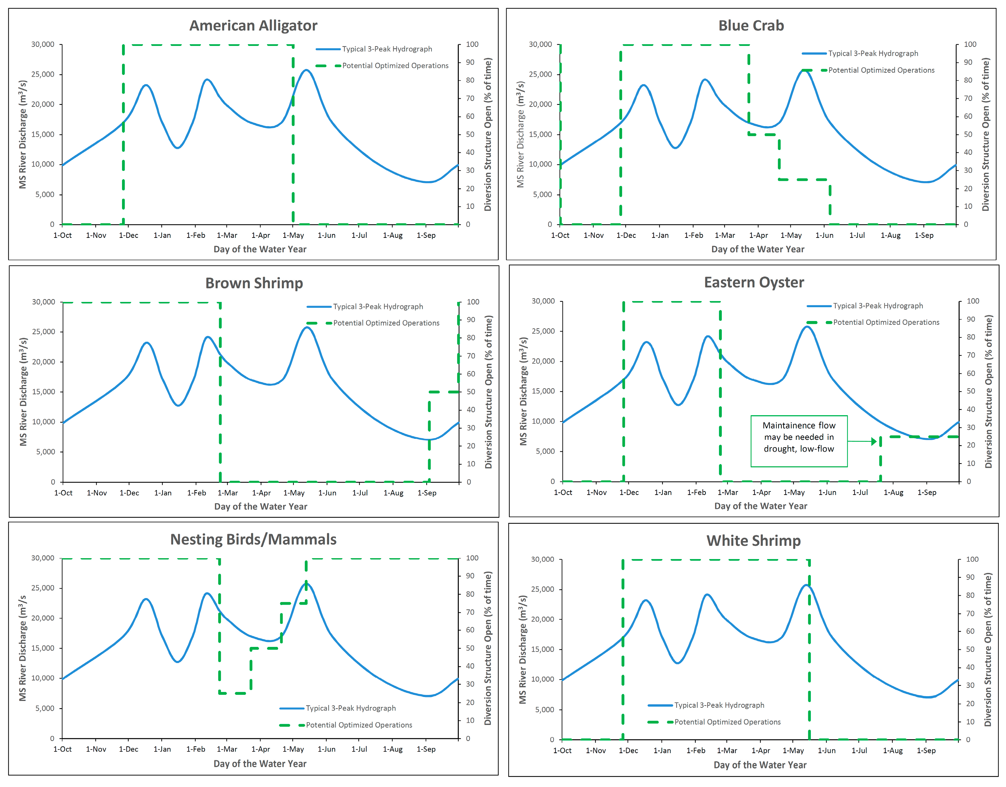
  • The American alligator (Alligator mississippiensis) prefers fresh marshes and will cease feeding over 10 parts per thousand (ppt) [89]. Sediment diversions are anticipated to increase the habitat quality and quantity for the alligator. Initial operations do not have to be as concerned as most of the outfall area is currently intermediate and brackish marsh, but the population will grow over time as more fresh habitats are created. American alligators can be negatively affected by water depths or stressed vegetation during the nesting season (mid-May to early September) [90]. Once a substantial population establishes, future operational strategies will need to consider minimizing extensive flooding during the nesting season, although the loss of a single year of nesting will not be detrimental to the entire population [90].
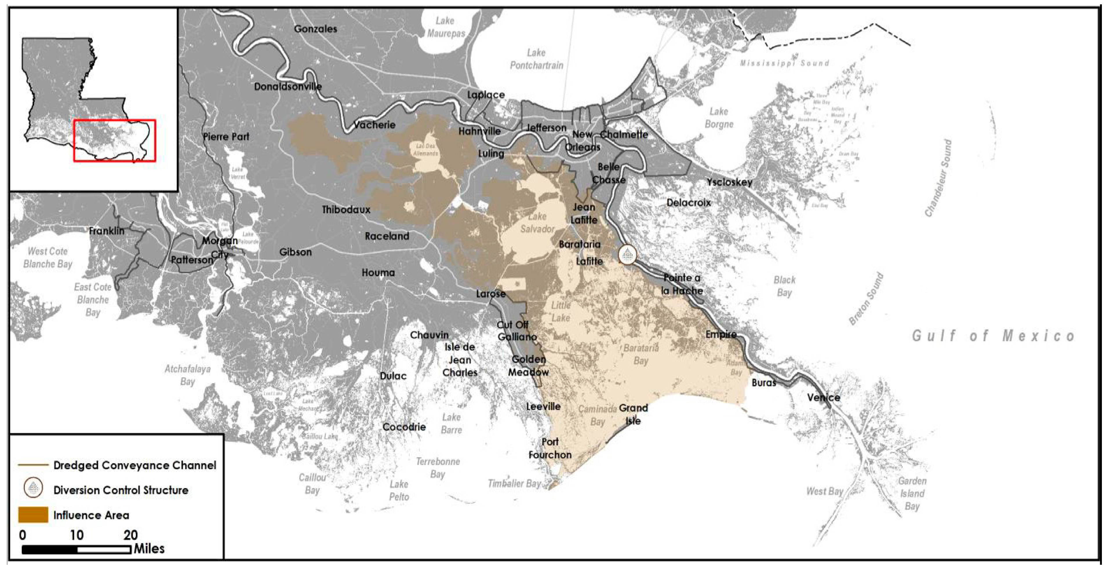
  • Blue crabs (Callinectes sapidus) in Barataria basin account for 18% of the state harvest [91] and have specific salinity requirements for various stages of their life cycle. Diversion operations should be most concerned with minimizing affects to mating females in March to May and during the peak spawning period, August to September [92]. Any estuarine recovery in May could also facilitate larval recruitment into Barataria basin [93].
  • The Eastern oyster (Crassostrea virginica) is a sessile animal that relies on distinct salinity regimes. The ideal mean salinity from May to September for subtidal oysters is 10 to 20 ppt [94] although 5 to 15 ppt is commonly used for an annual range. High salinity limitations (>20 ppt) are not a physiological response, but a predator and disease response. Extended low salinity (<5 ppt) during hot summer months (>25 °C) significantly affect oyster recruitment, survival and growth [95,96,97]. Oyster reefs can survive fresh water inputs in the winter months as long as the diversion operations are reduced or ceased by March. Occasionally, episodic flood events (every 3 to 5 years) during the spring or summer can cause high mortality that could potentially benefit oyster populations and reef health by reducing predator pressure, reducing the occurrence of disease, and providing shell for reefs to rebuild [98].
  • Diversions will increase habitats for most wetland mammals, including important fur-bearing species and invasive animals, as well as waterfowl and other water birds. Diversions will lead to increased habitat quality, quantity, and diversity, including submerged aquatic vegetation (SAVs). Increased nutrients from diversion operations are likely to result in increased marsh damage from invasive species, such as nutria and feral hogs [99,100] and management programs may need to be expanded to address the increased herbivory. In addition, some species of birds nest on or just above the marsh surface in the spring and summer, which could be disrupted by a rapid rising of water level elevations from the opening of a diversion. Most species would re-nest if water levels recede within the nesting season (March to July), but even if they do not, other years without spring/summer flooding could offset losses during flood years.
  • White shrimp (Litopenaeus setiferus) seem to be more euryhaline than brown shrimp and able to tolerate lower salinities [101]. Diversion operations with minimal to no flow during summer to early fall should not affect offshore spawning of white shrimp, although spawning can occur in nearshore Gulf waters. Additionally, such minimal to no flow will likely have minimal effect on postlarvae recruitment, which occurs mostly in June and July, and juvenile development from July to December [102]. Over the past few decades, the relative abundance of brown to white shrimp has varied based on environmental conditions and fishing pressure. Potentially, diversion operations could shift the relative abundance and commercial influences to more white shrimp than brown shrimp.
  • Barataria basin accounts for 44% of the inshore brown shrimp (Farfantepenaeus aztecus) harvest in Louisiana [102]. Diversion operations are unlikely to affect brown shrimp spawning which occurs further offshore, however postlarvae shrimp migrate inshore from February to April and spend March to July in the estuary as juveniles. If opened in late winter to early spring, a sediment diversion could have an effect on postlarvae recruitment into the estuary unless the diversion closing and estuary salinity recovery was timed with recruitment stages.
Fish and wildlife will likely adapt quickly, whereas it is harder and takes longer for fishers and other natural resource users to adapt. Fishers, hunters, and people who use the wetlands for commercial and recreational activities have long held economic and cultural significance in Louisiana. Changes in the distribution and abundance of species could have socio-economic effects on their user groups. Operational strategies need to appropriately balance the urgency of addressing coastal land loss with the importance of minimizing and mitigating adverse socio-economic affects, to the extent economically and scientifically feasible within the primary objective of land-building.

4. Discussion

After developing optimized operations based on each specific parameter, the working group analyzed the similarities and discrepancies in each of the operational scenarios to develop a potential overall strategy that would maximize land-building while also taking into account the complex ecological and social landscape. By focusing on winter peaks, the duration of diversion operations can gradually decrease over the water year and become more targeted on shorter operational periods with the greatest sediment load. One potential operational strategy, depicted in Figure 7, is based on a three-peak hydrograph typology. In this instance, the diversion would be operated over the entire first winter peak of the water year. The diversion would then be operated over most of the second winter peak but would close by March 1, even though river flow is still flowing at nearly 20,000 m3/s, to facilitate estuarine recovery during a specifically sensitive period for vegetation, fish and wildlife species and some commercially important fishery. Operations on the third peak (typically in the spring) are focused on the rising limb of the event to capture the most sediment, while also limiting the duration of opening and quantity of fresh water entering the basin. A measure that combines flow and sediment load, plus ecosystem and community needs, should be used to determine if and for how long the diversion should be operated during spring and summer flood peaks. Additional recommendations were developed that examined the social, economic, governance and legal issues surrounding diversion operations. These recommendations can be viewed at http://mississippiriverdelta.org/diversion-ops-report.

5. Conclusions

The future of coastal Louisiana will include complex and dynamic changes to the environmental, social and economic components, with or without any human intervention. Management actions, such as sediment diversions, will change the system from how it functions today, however a future without human intervention will be even more drastic to the natural and human landscape of coastal Louisiana. Developing operational strategies for implementation of a sediment diversion that maximizes land-building while also balancing the needs of the ecosystem and communities is a complex and challenging task. No matter what operational strategies are selected and implemented, changes to the Barataria Basin are inevitable. These changes will affect the vegetation, fish and wildlife species, and the natural resource users that rely on those species for sustenance or income. It is important to develop operational strategies that achieve the primary objective of a sediment diversion—to build and sustain land—while also taking into account the complex and often uncertain interactions of the ecological and social landscape. A general optimization strategy has been outlined in which diversion operations are guided by sediment monitoring and are focused on the non-growing season with shorter duration operations during the high sediment rising limb of the hydrographs in the growing season. Potential operational strategies need to be further tested and modeled to determine the best approach for successfully implementing a sediment diversion. Ultimately, the inherent adaptability of the diversion operations ensures that with the proper monitoring and assessment, we can test, learn, and modify operational strategies based on the outcomes observed on the landscape. A strong adaptive management program that includes robust baseline data before the diversion is implemented will help provide a level of confidence as we tackle this large-scale restoration project given the underlying current and future uncertainties and changes of the landscape and society’s response compounded by future climate change impacts.

Acknowledgments

We would like to thank the guest experts who participated and contributed vital expertise in one or more of the meetings, including Andrew Barron, Sam Bentley, Matt Bethel, Martin Bourgeois, Jim Boyd, Steve Cochran, Brady Couvillion, Mark Davis, John Day Jr., Henrietta DeGroot, JoAnne DeRouen, Ioannis Georgiou, Sean Graham, Scott Hemmerling, Duncan Kemp, Megan LaPeyre, Chunyan Li, John Lopez, Doug Meffert, Irv Mendelssohn, Ehab Meselhe, Corey Miller, David Muth, Ronnie Paille, Kristina Peterson, Rosina Phillipe, Kimberly Reyher, Lawrence Rozas, Shaye Sable, Leonard Shabman, Greg Snedden, Thomas Soniat, Christopher Swarzenski, Scott Duke-Sylvester, Jim Tripp, David Walther, Andrew Wilson, Carol Wilson, Maura Wood, Kehui Xu and Tracy Yandle. Their contributions to the working group meetings do not represent and should not be seen as an endorsement of the contents of this manuscript. Additional thanks to the support of Alisha Renfro, Estelle Robichaux and Rachel Rhode. This work was funded by the Walton Family Foundation.

Author Contributions

Natalie S. Peyronnin conceived, designed and facilitated the working group; authors analyzed data and contributed based on area of expertise as described in Table 1 (River Hydrology and Sediment Loads: Alexander S. Kolker and Alex McCorquodale; Basin Geology and Land-Building: Alexander S. Kolker and Robert R. Twilley; Water Quality: Dubravko Justic and John R. White; Wetland Health: Dubravko Justic, John A. Nyman, Jenneke M. Visser and John R. White; Fish and Wildlife Species: James H. Cowan, Jr., Earl Melancon Jr. and John A. Nyman; Communities, User Groups and Socio-Economics: Rex H. Caffey, James H. Cowan, Jr., Shirley B. Laska, Earl Melancon Jr. and John A. Nyman; and Governance, Legal and Stakeholder Involvement: Rex H. Caffey, Shirley B. Laska and James G. Wilkins); Natalie S. Peyronnin wrote the paper.

Conflicts of Interest

The authors declare no conflict of interest. The funding sponsors had no role in the design of the study; in the collection, analyses, or interpretation of data; in the writing of the manuscript, and in the decision to publish the results.

References

  1. Ericson, J.P.; Vörösmarty, C.J.; Dingman, S.L.; Ward, LG.; Meybeck, M. Effective sea-level rise and deltas: Causes of change and human dimension implications. Glob. Planet. Chang. 2006, 50, 63–82. [Google Scholar] [CrossRef]
  2. Giosan, L.; Syvitski, J.; Constantinescu, S.; Day, J. Protect the world’s deltas. Nature 2014, 516, 31–33. [Google Scholar] [CrossRef] [PubMed]
  3. Coastal Protection and Restoration Authority of Louisiana (CPRA). Louisiana’s Coastal Master Plan for a Sustainable Coast; Coastal Protection and Restoration Authority of Louisiana: Baton Rouge, LA, USA, 2012.
  4. Peyronnin, N.S.; Green, M.; Richards, C.P.; Owens, A.; Reed, D.; Chamberlain, J.; Groves, D.G.; Rhinehart, K.; Belhadjali, K. Louisiana’s 2012 coastal master plan: Overview of a science-based and publicly informed decision-making process. J. Coast. Res. 2013, 67, 1–15. [Google Scholar] [CrossRef]
  5. Coastal Protection and Restoration Authority of Louisiana (CPRA). Louisiana’s Coastal Master Plan for a Sustainable Coast; Coastal Protection and Restoration Authority of Louisiana: Baton Rouge, LA, USA, 2017.
  6. Gagliano, S.M. An approach to multiuse management in the Mississippi Delta system. In Deltas: Models for Exploration; Broussard, M.L., Ed.; Houston Geological Society: Houston, TX, USA, 1975; pp. 223–238. [Google Scholar]
  7. Paola, C.; Twilley, R.; Edmonds, D.; Kim, W.; Mohrig, D.; Parker, G. Natural processes in delta restoration: Application to the Mississippi delta. Ann. Rev. Mar. Sci. 2011, 3, 67–91. [Google Scholar] [CrossRef] [PubMed]
  8. Gagliano, S.; Coleman, J. Cyclic Sedimentation in the Mississippi River Deltaic Plain. Gulf Coast Assoc. Geol. Soc. Trans. 1964, 14, 67–80. [Google Scholar]
  9. Wells, J.T.; Coleman, J.M. Wetland Loss and the Subdelta Life Cycle. Estuar. Coast. Shelf Sci. 1987, 25, 111–125. [Google Scholar] [CrossRef]
  10. Barry, J.M. Rising tide: The great Mississippi flood of 1927 and how it changed America. In Touchstone, 1st ed.; Simon & Schuster: New York, NY, USA, 1998; pp. 1–524. ISBN 0684840022. [Google Scholar]
  11. Davis, D.W. Crevasses on the lower course of the Mississippi River. In Coastal Zone ’93; American Society of Civil Engineers: New York, NY, USA, 1993; pp. 360–378. [Google Scholar]
  12. Day, J.; Kemp, G.P.; Freeman, A.; Muth, D.P. Perspectives on the Restoration of the Mississippi Delta: The Once and Future Delta; Day, J., Kemp, G.P., Freeman, A., Muth, D.P., Eds.; Springer: New York, NY, USA, 2014. [Google Scholar]
  13. Craig, N.J.; Turner, R.E.; Day, J.W. Land loss in coastal Louisiana. Environ. Manag. 1979, 3, 133–144. [Google Scholar] [CrossRef]
  14. Boesch, D.F.; Josselyn, M.N.; Mehta, A.J.; Morris, J.T.; Nuttle, W.K.; Simenstad, C.A.; Swift, D.J. Scientific assessment of coastal wetland loss, restoration and management in Louisiana. J. Coast. Res. 1994, i–v, 1–103. [Google Scholar]
  15. Kesel, R.H. The role of the Mississippi River in wetland loss in southeastern Louisiana, USA. Environ. Geol. Water Sci. 1989, 13, 183–193. [Google Scholar] [CrossRef]
  16. Couvillion, B.R.; Barras, J.A.; Steyer, G.D.; Sleavin, W.; Fischer, M.; Beck, H.; Trahan, N.; Griffin, B.; Heckman, D. Land Area Change in Coastal Louisiana from 1932 to 2010; U.S. Geological Survey: Reston, VA, USA, 2011.
  17. Roberts, H.H. Dynamic changes of the holocene Mississippi river delta plain: The delta cycle. J. Coast. Res. 1997, 13, 605–627. [Google Scholar]
  18. Kolker, A.S.; Allison, M.A.; Hameed, S. An evaluation of subsidence rates and sea-level variability in the northern Gulf of Mexico. Geophys. Res. Lett. 2011, 38, L21404. [Google Scholar] [CrossRef]
  19. Day, J.W.; Boesch, D.F.; Clairain, E.J.; Kemp, G.P.; Laska, S.B.; Mitsch, W.J.; Orth, K.; Mashrigui, H.; Reed, D.J.; Shabman, L.; et al. Restoration of the Mississippi Delta: Lessons from Hurricanes Katrina and Rita. Science 2007, 315, 1679–1684. [Google Scholar] [CrossRef] [PubMed]
  20. Gagliano, S.M.; Hyuck, J.K.; Van Beek, J.L. Deterioration and restoration of coastal wetlands. Coast. Eng. Proc. 1970, 12, 1767–1781. [Google Scholar] [CrossRef]
  21. Tripp, J.T.; Herz, M. Wetland preservation and restoration: Changing federal priorities. Va. J. Nat. Res. 1987, 7, 221. [Google Scholar]
  22. Louisiana Coastal Wetlands Planning, Protection and Restoration Act (CWPPRA) Program. Louisiana Coastal Wetlands Restoration Plan: Main Report, Environmental Impact Statement and Appendices; U.S. Army Corps of Engineers; U.S. Department of Agriculture; U.S. Department of Commerce; U.S. Department of the Interior; U.S. Environmental Protection Agency; Louisiana Department of Natural Resources: Baton Rouge, LA, USA, 1993.
  23. Louisiana Coastal Wetlands Conservation and Restoration Task Force and the Wetlands Conservation and Restoration Authority (LCWCRTF). Coast 2050: Toward a Sustainable Coastal Louisiana; Louisiana Department of Natural Resources: Baton Rouge, LA, USA, 1998.
  24. Coastal Protection and Restoration Authority of Louisiana (CPRA). Integrated Ecosystem Restoration and Hurricane Protection: Louisiana’s Comprehensive Master Plan for a Sustainable Coast; Coastal Protection and Restoration Authority of Louisiana: Baton Rouge, LA, USA, 2007.
  25. Twilley, R.R.; Couvillion, B.R.; Hossain, I.; Kaiser, C.; Owens, A.B.; Steyer, G.D.; Visser, J.M. Coastal Louisiana ecosystem assessment and restoration program: The role of ecosystem forecasting in evaluating restoration planning in the Mississippi river deltaic plain. Am. Fish. Soc. Symp. 2008, 64, 29–46. [Google Scholar]
  26. Kim, W.; Mohrig, D.; Twilley, R.; Paola, C.; Parker, G. Is it feasible to build new land in the Mississippi River Delta? EOS Trans. Am. Geophys. Union 2009, 90, 373–374. [Google Scholar] [CrossRef]
  27. Gagliano, S.M.; Culley, P.; Earle, D.W., Jr.; King, P.; Latiolas, C.; Light, P.; Rowland, A. Environmental Atlas and Multiuse Management Plan for South Central Louisiana; Louisiana State University: Baton Rouge, LA, USA, 1973. [Google Scholar]
  28. Wang, H.; Chen, Q.; Hu, K.; LaPeyre, M.K. A modeling study of the impacts of the Mississippi River diversion and sea-level rise on water quality of a deltaic estuary. Estuar. Coast. 2016, 6, 1–27. [Google Scholar] [CrossRef]
  29. Soniat, T.M.; Conzelmann, C.P.; Byrd, J.D.; Roszell, D.P.; Bridevaux, J.L.; Suir, K.J.; Colley, S.B. Predicting the effects of proposed Mississippi River diversions on oyster habitat quality; Application of an oyster habitat suitability index model. J. Shellfish Res. 2013, 32, 629–638. [Google Scholar] [CrossRef]
  30. Peyronnin, N.; Caffey, R.; Cowan, J.H., Jr.; Dubravko, J.; Kolker, A.; Laska, S.; McCorquodale, A.; Melancon, E., Jr.; Nyman, J.A.; Twilley, R.; et al. Building Land in Coastal Louisiana: Expert Recommendations for Operating a Successful Sediment Diversion that Balances Ecosystem and Community Needs. Available online: http://www.mississippiriverdelta.org/files/2016/07/MRDRC_OWG_Main_Electronic.pdf (accessed on 15 March 2017).
  31. Meselhe, E.A.; Georgiou, I.; Allison, M.A.; McCorquodale, J.A. Numerical modeling of hydrodynamics and sediment transport in lower Mississippi at a proposed delta building diversion. J. Hydrol. 2012, 472, 340–354. [Google Scholar] [CrossRef]
  32. U.S. Army Corps of Engineers (USACE). Ecosystem Restoration Study: Louisiana Coastal Area (LCA), Louisiana, Volume 1: LCA Main Report; U.S. Army Corps of Engineers: Baton Rouge, LA, USA, 2004. Available online: www.lca.gov/Library/FileDownload.aspx?ProdType=0&id=1137 (accessed on 15 March 2017).
  33. Milliman, J.D.; Farnsworth, K.L.; Jones, P.D.; Xu, K.H.; Smith, L.C. Climatic and anthropogenic factors affecting river discharge to the global ocean, 1951–2000. Glob. Planet. Chang. 2008, 62, 187–194. [Google Scholar] [CrossRef]
  34. Tao, B.; Tian, H.; Ren, W.; Yang, J.; Yang, Q.; He, R.; Cai, W.; Lohrenz, S. Increasing Mississippi river discharge throughout the 21st century influenced by changes in climate, land use, and atmospheric CO2. Geophys. Res. Lett. 2014, 41, 4978–4986. [Google Scholar] [CrossRef]
  35. Nakaegawa, T.; Kitoh, A.; Hosaka, M. Discharge of major global rivers in the late 21st century climate projected with the high horizontal resolution MRI-AGCMs. Hydrol. Process 2013, 27, 3301–3318. [Google Scholar] [CrossRef]
  36. Falloon, P.D.; Betts, R.A. The impact of climate change on global river flow in HadGEMI simulations. Atmos. Sci. Lett. 2006, 7, 62–68. [Google Scholar] [CrossRef]
  37. Melillo, J.M.; Richmond, T.C.; Yohe, G.W. Climate Change Impacts in the United States: The Third National Climate Assessment. U.S. Glob. Chang. Res. Program 2014, 841. [Google Scholar] [CrossRef]
  38. McCorquodale, J.A. Hydrograph Topologies and Sediment Regimes for Evaluation of Operating a Diversion. 2017; submitted for publication. [Google Scholar]
  39. Kolker, A.S.; Miner, M.D.; Weathers, H.D. Depositional Dynamics in a River Diversion Receiving Basin: The Case of the West Bay Mississippi River Diversion. Estuar. Coast. Shelf Sci. 2012, 106, 1–12. [Google Scholar] [CrossRef]
  40. Shaw, J.B.; Mohrig, D. The importance of erosion in distributary channel network growth, Wax Lake Delta, Louisiana, USA. Geology. 2014, 42, 31–34. [Google Scholar] [CrossRef]
  41. Wilson, C.A.; Allison, M.A. An Equilibrium Profile Model for Retreating Marsh Shorelines in Southeast Louisiana. Estuar. Coast. Shelf Sci. 2008, 80, 483–494. [Google Scholar] [CrossRef]
  42. Esposito, C.R.; Georgiou, I.Y.; Kolker, A.S. Hydrodynamic and Geomorphic Controls on Mouth Bar Evolution. Geophys. Res. Lett. 2013, 40, 1540–1545. [Google Scholar] [CrossRef]
  43. Lopez, J.; Henkel, T.; Moshogianis, A.; Baker, A.; Boyd, E.; Hillman, E.; Batker, D. Evolution of Mardi Grad Pass within the Bohemia Spillway of the Mississippi Delta in Southeast Louisiana: March 2012 through December 2013; Lake Pontchartrain Basin Foundation: New Orleans, LA, USA, 2014. [Google Scholar]
  44. Lacey, G. Stable Channels in Alluvium; Institution of Civil Engineers: London, UK, 1929; Volume 229, pp. 258–384. [Google Scholar]
  45. Cao, S.; Knight, D.W. Review of regime theory of alluvial channels. J. Hydrodyn. Ser. B 2002, 3, 1–3. [Google Scholar] [CrossRef]
  46. Connor, P.F.; Lopez, J.; Henkel, T.; Hillmann, E.; Smith, P.; Baker, D.; Butcher, K. Hydrocoast Salinity Maps 1:1,100,000, Lake Pontchartrain Basin Foundation, 2016. Available online: http://saveourlake.org/lpbf-programs/coastal/hydrocoast-maps (accessed on 17 March 2017).
  47. Wellner, R.; Beaubouef, R.; Van Wagoner, J.; Roberts, H.; Sun, T. Jet-plume depositional bodies—The primary building blocks of Wax Lake Delta. Gulf Coast Assoc. Geol. Soc. Trans. 2005, 55, 867–909. [Google Scholar]
  48. Wright, L. Sediment transport and deposition at river mouths: A synthesis. Geol. Soc. Am. Bull. 1977, 88, 857. [Google Scholar] [CrossRef]
  49. Snedden, G.; Steyer, G. Predictive occurrence models for coastal wetland plant communities: Delineating hydrologic response surfaces with multinomial logistic regression. Estuar. Coast. Shelf Sci. 2013, 118, 11–23. [Google Scholar] [CrossRef]
  50. Snedden, G.; Cretini, K.; Patton, B. Inundation and salinity impacts to above and belowground productivity in Spartina patens and Spartina alterniflora in the Mississippi River deltaic plain: Implications for using river diversions as restoration tools. Ecol. Eng. 2015, 81, 133–139. [Google Scholar] [CrossRef]
  51. Visser, J.M.; Sandy, E.R. The effects of flooding on four common Louisiana marsh plants. Gulf Mex. Sci. 2009, 21–29. [Google Scholar] [CrossRef]
  52. Allison, M.A.; Meselhe, E.A. The Use of Large Water and Sediment Diversions in the Lower Mississippi River (Louisiana) for Coastal Restoration. J. Hydrol. 2010, 387, 346–360. [Google Scholar] [CrossRef]
  53. Thomson, D.; Shaffer, G.; McCorquodale, J.A. A potential interaction between sea-level rise and global warming: Implications for coastal stability on the Mississippi River Deltaic Plain. J. Glob. Planet. Chang. 2001, 670, 49–59. [Google Scholar] [CrossRef]
  54. Feng, Z.; Li, C. Cold-front-induced flushing of the Louisiana Bays. J. Mar. Syst. 2010, 82, 252–264. [Google Scholar] [CrossRef]
  55. Allison, M.A.; Demas, D.; Ebersole, B.; Kleiss, B.; Little, C.; Meselhe, E. A water and sediment budget for the lower Mississippi–Atchafalaya River in flood years 2008–2010: Implications for sediment discharge to the oceans and coastal restoration in Louisiana. J. Hydrol. 2012, 432–433, 84–97. [Google Scholar] [CrossRef]
  56. Reed, D.J. Patterns of sediment deposition in subsiding coastal salt marshes, Terrebonne Bay, Louisiana: The role of winter storms. Estuaries 1989, 12, 222. [Google Scholar] [CrossRef]
  57. Roberts, H.; Oscar, K.; Walters, S. Winter Storm Impacts on Chenier Plain Coast of Southwestern Louisiana. Gulf Coast Assoc. Geol. Soc. Trans. 1989, 39, 73. [Google Scholar]
  58. Carle, M.; Sasser, C.; Roberts, H. Accretion and vegetation community change in the Wax Lake Delta following the historic 2011 Mississippi River flood. J. Coast. Res. 2015, 313, 569–587. [Google Scholar] [CrossRef]
  59. Freeman, A.; Jose, F.; Roberts, H.; Stone, G. Storm induced hydrodynamics and sediment transport in a coastal Louisiana lake. Estuar. Coast. Shelf Sci. 2015, 161, 65–75. [Google Scholar] [CrossRef]
  60. Roberts, H.H.; De Laune, R.D.; White, J.; Li, C.; Braud, D.; Weeks, E. Delta Development and Coastal Marsh Accretion During Cold Front Passages and River Floods: Relevance to River Diversions—Final Report; Coastal Studies Institute, Louisiana State University: Baton Rouge, LA., USA, 2016. [Google Scholar]
  61. Roberts, H.H.; DeLaune, R.D.; White, J.R.; Li, C.; Sasser, C.E.; Braud, D.; Weeks, E.; Khalil, S. Floods and Cold Front Passages: Impacts on Coastal Marshes in a River Diversion Setting (Wax Lake Delta Area, Louisiana). J. Coast. Res. 2015, 31, 1057–1068. [Google Scholar] [CrossRef]
  62. Shaffer, G.P.; Sasser, C.E.; Gosselink, J.G.; Rejmanek, M. Vegetation dynamics in the emerging Atchafalaya Delta, Louisiana, USA. J. Ecol. 1992, 80, 677–687. [Google Scholar] [CrossRef]
  63. Visser, J.; Peterson, J. The effects of flooding duration and salinity on three common upper estuary plants. Wetlands 2015, 35, 625–631. [Google Scholar] [CrossRef]
  64. Van Zomeren, C.M.; White, J.R.; DeLaune, R.D. Fate of nitrate in vegetated brackish coastal marsh. Soil Sci. Soc. Am. J. 2012, 76, 1919–1927. [Google Scholar] [CrossRef]
  65. Reddy, K.R.; De Laune, R.D. Biogeochemistry of Wetlands: Science and Applications; CRC Press: Boca Raton, FL, USA, 2008; ISBN-10: 1566706785. [Google Scholar]
  66. Das, A.; Justic, D.; Inoue, M.; Hoda, A.; Huang, H.; Park, D. Impacts of Mississippi River diversions on salinity gradients in a deltaic Louisiana estuary: Ecological and management implications. Estuar. Coast. Shelf Sci. 2012, 111, 17–26. [Google Scholar] [CrossRef]
  67. Meselhe, E.A.; Sadid, K.M.; Allison, M.A. Riverside morphological response to pulsed sediment diversions. Geomorphology 2016, 270, 184–202. [Google Scholar] [CrossRef]
  68. Das, A.; Justic, D.; Swenson, E. Modeling estuarine-shelf exchanges in a deltaic estuary: Implications for coastal carbon budgets and hypoxia. Ecol. Model. 2010, 221, 978–985. [Google Scholar] [CrossRef]
  69. Roblin, R. Water Quality Modeling of Freshwater Diversions in the Pontchartrain Estuary. Masters’s Thesis, University of New Orleans, New Orleans, LA, USA, 2008. [Google Scholar]
  70. Rivera-Monroy, V.H.; Branoff, B.; Meselhe, E.; McCorquodale, A.; Dortch, M.; Steyer, G.D.; Visser, J.; Wang, H. Landscape-level estimation of nitrogen removal in coastal Louisiana wetlands: Potential sinks under different restoration scenarios. J. Coast. Res. 2013, 67, 75–87. [Google Scholar] [CrossRef]
  71. Justic, D.; Rabalais, N.; Turner, R. Coupling between climate variability and coastal eutrophication: Evidence and outlook for the northern Gulf of Mexico. J. Sea Res. 2005, 54, 25–35. [Google Scholar] [CrossRef]
  72. Roy, E.D.; Smith, E.A.; Bargu, S.; White, J.R. Will Mississippi River diversions designed for coastal restoration cause harmful algal blooms in receiving estuaries? Ecol. Eng. 2016, 91, 350–364. [Google Scholar] [CrossRef]
  73. Dettmann, E.H. Effect of water residence time on annual export and denitrification of nitrogen in estuaries: A model analysis. Estuaries 2001, 24, 481–490. [Google Scholar] [CrossRef]
  74. Lane, R.R.; Day, J.W.; Justic, D.; Reyes, E.; Marx, B.; Day, J.N.; Hyfield, E. Changes in stoichiometric Si, N and P ratios of Mississippi River water diverted through coastal wetlands to the Gulf of Mexico. Estuar. Coast. Shelf Sci. 2004, 60, 1–10. [Google Scholar] [CrossRef]
  75. Huang, H.; Justic, D.; Lane, R.; Day, J.; Cable, J. Hydrodynamic response of the Breton Sound estuary to pulsed Mississippi River inputs. Estuar. Coast. Shelf Sci. 2011, 95, 216–231. [Google Scholar] [CrossRef]
  76. Perez, B.; Day, J.W.; Justic, D.; Lane, R.R.; Twilley, R.R. Nutrient stoichiometry, freshwater residence time, and nutrient retention in a river-dominated estuary in the Mississippi Delta. Hydrobiol. 2011, 658, 41–54. [Google Scholar] [CrossRef]
  77. Sklar, F.H.; Browder, J.A. Coastal environmental impacts brought about by alterations to freshwater flow in the Gulf of Mexico. Coast. Manag. 1998, 22, 547–562. [Google Scholar] [CrossRef]
  78. Sasser, C.E.; Visser, J.M.; Mouton, E.; Linscombe, J.; Hartley, S.B. Vegetation Types in Coastal Louisiana in 2013. U.S. Geolog. Surv. Sci. Investig. Map 3290 2014. [Google Scholar] [CrossRef]
  79. Visser, J.; Duke-Sylvester, S.; Carter, J.; Broussard, W. A computer model to forecast wetland vegetation changes resulting from restoration and protection in coastal Louisiana. J. Coast. Res. 2013, 67, 51–59. [Google Scholar] [CrossRef]
  80. Nyman, J.; Baltz, D.; Kaller, M.; Leberg, P.; Richards, C.; Romaire, R.; Soniat, T. Likely changes in habitat quality for fish and wildlife in coastal Louisiana during the next fifty years. J. Coast. Res. 2013, 67, 60–74. [Google Scholar] [CrossRef]
  81. Cowan, J.H., Jr.; Grimes, C.B.; Shawn, R.F. Life history, history, hysteresis and habitat changes in Louisiana’s coastal ecosystem. Bull. Mar. Sci. 2008, 83, 197–215. [Google Scholar]
  82. Baltz, D.; Rakocinski, C.; Fleeger, J. Microhabitat use by marsh-edge fishes in a Louisiana estuary. Environ. Biol. Fishes 1993, 36, 109–126. [Google Scholar] [CrossRef]
  83. Rozas, L.; Zimmerman, R. Small-scale patterns of nekton use among marsh and adjacent shallow nonvegetated areas of the Galveston Bay Estuary, Texas (USA). Mar. Ecol. Prog. Ser. 2000, 193, 217–239. [Google Scholar] [CrossRef]
  84. Browder, J.; Bartley, H.; Davis, K. A probabilistic model of the relationship between marshland-water interface and marsh disintegration. Ecol. Model. 1985, 29, 245–260. [Google Scholar] [CrossRef]
  85. Browder, J.; May, L.; Rosenthal, A.; Gosselink, J.; Baumann, R. Modeling future trends in wetland loss and brown shrimp production in Louisiana using thematic mapper imagery. Remote Sens. Environ. 1989, 28, 45–59. [Google Scholar] [CrossRef]
  86. Lewis, K.A.; de Mutsert, K.; Steenbeek, J.; Peele, J.; Cowan, J.H.; Buszowski, J. Employing ecosystem models and geographic information systems (GIS) to investigate the response of changing marsh edge on historical biomass of estuarine nekton in Barataria Bay, Louisiana, USA. Ecol. Model. 2016, 331, 129–141. [Google Scholar] [CrossRef]
  87. Fry, B.; Cieri, M.; Hughes, J.; Tobias, C.; Deegan, L.; Peterson, B. Stable isotope monitoring of benthic–planktonic coupling using salt marsh fish. Mar. Ecol. Prog. Ser. 2008, 369, 193–204. [Google Scholar] [CrossRef]
  88. De Mutsert, K.; Cowan, J.; Walters, C. Using Ecopath with Ecosim to explore nekton community response to freshwater diversion into a Louisiana estuary. Mar. Coast. Fish. 2012, 4, 104–116. [Google Scholar] [CrossRef]
  89. Laurén, D.J. The effect of chronic saline exposure on the electrolyte balance, nitrogen metabolism, and corticosterone titer in the American alligator, Alligator mississippiensis. Comp. Biochem. Phys. A 1985, 81, 217–223. [Google Scholar] [CrossRef]
  90. Platt, S.G.; Hastings, R.W.; Brantley, C.G. Nesting ecology of the American alligator in southeastern Louisiana. In Proceedings of the Annual Conference of the Southeastern Association of Fish and Wildlife Agencies, Nashville, TN, USA, 23–27 September 1995; Volume 49, pp. 629–639. [Google Scholar]
  91. Bourgeois, M.; Marx, J.; Semon, K. Louisiana Blue Crab. In Fishery Management Plan; Louisiana Department of Wildlife and Fisheries: Baton Rouge, LA, USA, 2014; pp. 1–122. [Google Scholar]
  92. Guillory, V.; Elliot, M. A Review of Blue Crab Predators. In Proceedings of the Blue Crab Mortality Symposium, Lafayette, LA, USA, 28–29 May 1999; Gulf States Marine Fisheries Commission: Ocean Springs, MS, USA, 1999; pp. 69–83. [Google Scholar]
  93. Jaworski, E. The Blue Crab Fishery, Barataria Estuary, Louisiana; Center for Wetland Resources, Louisiana State University, LSU: Baton Rouge, LA, USA, 1972; Volume LSU-SG-72-01, p. 112. [Google Scholar]
  94. Cake, E.W., Jr. Habitat Suitability Index Models: Gulf of Mexico American Oyster; US Fish and Wildlife Service: Washington, DC, USA, 1983; Volume FWS/OBS-82/10.57, p. 37.
  95. LaPeyre, M.K.; Schwarting, L.; Miller, S. Baseline data for evaluating development trajectory and provision of ecosystem services of created fringing oyster reefs in Vermilion Bay, Louisiana. U.S. Geol. Surv. Open-File Rep. 2013, 1053, 43. [Google Scholar]
  96. Rouhani, S.; Oehrig, J. Generation of Oyster Survival Salinity Dose-Response Curves Using Nestier Tray Data; DWH Oyster NRDA Technical Working Group Report, DHW-AR0270362; NewFields, Inc.: Atlanta, GA, USA, 2015; p. 11. [Google Scholar]
  97. Rouhani, S.; Oehrig, J. Methodology Used to Determine the Spatial Extent of Fresh Water Impact in Barataria Bay and Black/Bay Breton Sound Basins in 2010; DWH Oyster NRDA Technical Working Group Report, DWH-AR0270373; NewFields, Inc.: Atlanta, GA, USA, 2015; p. 11. [Google Scholar]
  98. Dugas, R. Oyster Distribution and Density on the Productive Portion of State Seed Grounds in Southeastern Louisiana; Louisiana Department of Wildlife and Fisheries: Baton Rouge, LA, USA, 1977.
  99. Visser, J.; Sasser, C.; Cade, B. The effect of multiple stressors on salt marsh end-of-season biomass. Estuar. Coast. 2006, 29, 328–339. [Google Scholar] [CrossRef]
  100. Ialeggio, J.; Nyman, J. Nutria grazing preference as a function of fertilization. Wetlands 2014, 34, 1039–1045. [Google Scholar] [CrossRef]
  101. Doerr, J.; Liu, H.; Minello, T. Salinity selection by juvenile brown shrimp (Farfantepenaeus aztecus) and white shrimp (Litopenaeus setiferus) in a gradient tank. Estuar. Coast. 2015, 39, 829–838. [Google Scholar] [CrossRef]
  102. Bourgeois, M.; Landry, L.; Lightner, J.; Marx, J.; Semon, K. Louisiana Shrimp. In Fishery Management Plan; Louisiana Department of Wildlife and Fisheries: Baton Rouge, LA, USA, 2015; pp. 1–158. [Google Scholar]
Figure 1. Proposed location of the Mid-Barataria Sediment Diversion [5].
Water 09 00368 g001
Figure 2. Conceptual optimization of sediment diversion operations for building land only with no other constraints overlaid on a common three-peak hydrograph typology. Graphic notes when diversion could potentially be opened, not that it would be anticipated to be open for the entire time period.
Water 09 00368 g002
Figure 3. Hydrograph typologies of the Mississippi River based on 56 years of river flows and the historic rate of occurrence [38].
Water 09 00368 g003aWater 09 00368 g003b
Figure 4. Monthly distributions of potential river discharges over various thresholds for operations (Note: Legend is in cubic meters per second).
Water 09 00368 g004
Figure 5. Conceptualized operational strategy that optimizes vegetation health and minimizes loss of vegetation from prolonged and extensive flooding.
Water 09 00368 g005
Figure 6. Operations to “optimize” a specific species overlaid on one of the common three peak hydrograph typologies. Optimize means to leave at present-day status quo within the Barataria Basin. Graphic notes when diversion could potentially be opened, not that it would be anticipated to be open the entire time period.
Water 09 00368 g006
Figure 7. Potential operational strategy depicted on a three-peak hydrograph typology. Note: Although the diversion is depicted as 100% open or completely closed, each opening and closing could happen gradually over days or weeks.
Water 09 00368 g007
Table 1. Meetings and topics discussed by the working group.
Meeting TopicDateParameters Discussed
River Hydrology and Sediment Loads16 September 2015River flow, stage, velocity, flood peaks, trajectory, sediment concentrations, discharge, sediment transport and budget, sediment-water ratios (SWR), atmospheric conditions, climate change
Basin Geology and Land-Building16 October 2015Delta development (channel evolution, progradation, aggradation, subsidence), seasonal sedimentation, sediment transport, diversion discharge, velocity, sediment retention, cold fronts, turbidity, topography, bathymetry, soil salinity, substrate, erodibility, shear stress/strength
Water Quality20 November 2015Hydrodynamics, residence time, discharge, salinity, temperature, nutrients (flux, load), hypoxia, phytoplankton production, harmful algal blooms, sediment, turbidity, flocculation, disease, pathogens, hormones, pharmaceuticals, cold fronts
Wetland Health14 December 2015Habitat types, estuarine salinity gradients, saltwater intrusion, elevation, vegetation, salinity, invasive vegetation species, sediment (input, quality, composition), bulk density, nutrient loading rates, vegetative biomass, nitrogen availability and uptake, phosphorus, sulfates/sulfides, temperature, respiration rates, duration of flooding, growing season, vegetation stress, saltwater spikes
Fish and Wildlife Species13 January 2016Trophic productivity, salinity, species/community composition, dietary ranges, niche breadth, predator/prey relationships, species distribution, estuarine salinity gradients, habitat quality/value, species abundance, nutrients, water depth, sediment input, fish productivity, eutrophication, fishing practices, life cycles, fishing pressure, mortality, habitat requirements, indicator species
Communities, User Groups and Socio-Economics17 February 2016Economic value, river flow, stage, distributary width, discharge, flood risk, subsidence, sea level rise, storm seasons/surge, tides, salinity, turbidity, temperature, channelization, winds, velocity, elevation, transition costs, compensation, mitigation, sack and seed oyster fisheries, private and public oyster beds, leasing program, oyster cultch, shrimp production, blue crab stock, social behavior, politics, community adaptation, trust
Operational Strategies14 March 2016Hydrograph typologies and various operational strategies
Governance, Legal and Stakeholder Involvement13 April 2016Property rights, negligence, eminent domain, inverse condemnation, oyster lease acquisition and compensation programs, oyster lease dynamics, flow capacity, flow easements, salinity gradients, land trusts, public ownership, conservation easements, advisory groups, frontloading impacts, insurance, decision-making framework, transparency, trust, role of stakeholders, agencies and public officials in operations decisions

