Spatial Variations in the Surface Water Chemistry of Subtropical Peatlands (Central China) Linked to Anthropogenic Pressures


1
College of Resources and Environmental Science, South-Central University for Nationalities, Wuhan 430074, China
2
State Key Laboratory of Biogeology and Environmental Geology, School of Earth Sciences, China University of Geosciences, Wuhan 430074, China
3
Institute for Peat and Mire Research, State Environmental Protection Key Laboratory of Wetland Ecology and Vegetation Restoration, Northeast Normal University, Changchun 130024, China
4
School of Geography, University of Nottingham, Nottingham NG72RD, UK
*
Author to whom correspondence should be addressed.
Water 2017, 9(7), 505; https://doi.org/10.3390/w9070505
Submission received: 17 February 2017
/
Revised: 7 July 2017
/
Accepted: 7 July 2017
/
Published: 11 July 2017
Abstract
:Compared with the extensively surveyed temperate and boreal peatlands, subtropical peatlands have received rather little scientific attention. In this study, spatial variations in water chemistry were investigated in 57 samples collected from three subtropical peatlands (central China). Generally, water pH and major cation concentrations of these samples approached the characteristics of poor fens along the bog–rich fen gradient. Four distinct groups were identified by cluster analysis and principal component analysis. High concentrations of trace elements in Group I were probably linked to airborne dust pollutants from a nearby road under construction. Low pH values and low major cation concentrations in Group II may be attributed to the great cation exchange capacity of Sphagnum. In contrast, samples in Group III, mainly collected from sites suffering from Sphagnum harvest, showed high pH levels and major cation concentrations. Relatively low concentrations of trace elements (except boron) in Group IV can be regarded as reference conditions for restoration efforts in these peatlands. Taken together, spatial variations in the water chemistry of the three peatlands were closely linked to natural processes (e.g., cation exchange of Sphagnum) and anthropogenic pressures (e.g., Sphagnum harvest). Overall, the mean health risk values of the six trace elements were low, indicating good water quality in these peatlands. This study provided baseline water chemistry information for the sustainable management of these subtropical peatlands, as well as other similar ecosystems.
1. Introduction
Peatlands are unique and valuable ecosystems, covering approximately 3% of the total terrestrial area [1]. Despite their relatively small distribution area, peatlands play vital roles in regulating the global carbon cycle, maintaining biodiversity, as well as storing and purifying water [2]. In general, large areas of mires or peatlands are developed in temperate and boreal landscapes between 50° and 70° N due to the humid and cold climatic conditions [3]. Due to the continued accumulation of organic matter, peatlands are generally acidic and ombrotrophic environments [1]. According to their water chemistry (mainly pH and calcium content) and vegetation, peatlands are classified as different types, such as bogs, poor fens, and rich fens [4,5]. This widely-used classification is mainly based on extensive surveys of temperate and boreal peatlands (e.g., Canadian and European peatlands) [6,7,8]. However, investigations of subtropical or tropical peatlands are limited.
In mountainous regions of the subtropical zone, some peatlands develop in topographically low and closed basins [9]. Vegetation types of these montane peatlands are characterized by Sphagnum. These subtropical peatlands provide important ecological services, such as offering vital habitats for many threatened plants and animals, in addition to water sources for the low reaches [10,11]. For example, Dajiuhu Peatland, a Ramsar Site located in the west of Hubei Province, is one of the headwaters of the Danjiangkou Reservoir that is the water source of the middle route of the South-North Water Transfer Project [12]. Unfortunately, these peatlands are increasingly threatened by human activities, such as Sphagnum harvest, grazing, and tourism [12,13].
Surface water always contains various dissolved substances from the soil, air, and organisms, and hence water chemistry can be a mirror of the environmental conditions in wetlands [6,14,15]. Anthropogenic disturbances could lead to water quality degradation in these ecologically important ecosystems [2,7,16,17]. For example, peat-harvested peatlands possess higher concentrations of major cations compared to unharvested peatlands, which may be attributed to the exposure of minerotrophic fen peat [18]. In addition, airborne dust from roads and factories could cause metal enrichment in nearby peatlands [17,19]. In central China, the subtropical monsoonal climate and mountainous terrain with a mean elevation of 1500 to 1800 m a.s.l. render a configuration of air temperature (mean of 7–14 °C) and precipitation (above 1300 mm), and thus favors the growth of peatland plants and the accumulation of peats. To date, surface water chemical components of subtropical montane peatlands have received little scientific attention [12]. An investigation of the water chemistry of peatlands in the subtropical monsoon climate, however, might improve our understanding on the generic characteristics of peatland water chemistry in the Northern Hemisphere.
In this study, three subtropical montane peatlands (Dajiuhu Peatland, Erxianyan Peatland, and Qizimeishan Peatland) in central China were selected and surface water samples were collected. We hypothesize that (1) pH and major cations (e.g., Ca) of sampling points will approach the characteristics of boreal bogs or poor fens, suggested by the dominance of Sphagnum plants [8], and (2) the sampling points suffering from anthropogenic pressures (e.g., Sphagnum harvest and airborne road pollutants) will show higher concentrations of major cations and metals than undisturbed sites. To test the hypotheses and reveal baseline information of water quality for the sustainable management of these peatlands, water chemical components in three peatlands were first investigated. Second, we discussed the variations in water chemistry among sampling points and their potential drivers. Lastly, the health risk of several trace elements in surface waters was assessed.
2. Materials and Methods
2.1. Site Description
The studied peatlands, named Dajiuhu Peatland (DJH; 31°28′56″N, 109°59′07″E; ~1760 m a.s.l.), Erxianyan Peatland (EXY; 29°43′31″N, 108°48′12″E; ~1550 m a.s.l.), and Qizimeishan Peatland (QZMS; 29°57′50″N, 109°45′11″E; ~1800 m a.s.l.), are located in western Hubei Province in central China (Figure 1). The total area of Sphagnum patches in DJH, EXY, and QZMS is about 280, 20, and 970 ha, respectively [11]. The lithology in this region is characterized by limestone and dolomite bedrock. DJH is situated at Dajiuhu Village on the southwestern border of the Shennongjia Forest District, which is a member of the Global 200 ecoregions [20]. The relatively closed environment provided an intact natural condition for the growth of the peatland up to 2012, after which tourism began to develop. Acting as a water source for the middle route of the South-North Water Transfer Project, the peatland is of importance in maintaining drinking water safety for local residents and inhabitants of northern China. The maximum depth of peat in this peatland is about 3.5 m [10]. EXY is surrounded by farmlands, meadows, and hilly vegetation, and is thus somewhat destroyed and degraded due to agricultural activities and Sphagnum harvest. QZMS is located at a relatively high altitude and is surrounded by lower population density compared to the other two sites. Additionally, it was immediately classified as a natural reserve after being discovered in 2005 [21]. QZMS, therefore, has suffered from less anthropogenic disturbance and maintains a relatively natural environmental condition. The average peat depths in the two peatlands were around 100 cm. Peat basal ages of the three peatlands were about 11.5–10 ka BP [22]. The dominant plants observed during the investigation were Carex sp., Sphagnum palustre, Juncus sp., Phyllostachys heteroclada, Veratrum sp., and Sanguisorba officinalis. The detailed compositions of each site are described in Reference [11].
2.2. Measurements and Sampling
Water samples taken in peatlands can show gradual or abrupt changes in water chemistry due to variations in several factors (e.g., sampling time, vegetation communities, and microtopography) [8]. To avoid the impacts of sampling time (e.g., season and month) on the comparisons between different samples, all of the samplings were conducted and completed in July 2014. There were no flooding or drought events intervening hydroclimatic conditions during the sampling. Sampling points were designed along two or three transects from hummock to hollow in the center of a continuous peatland in each region (DJH, EXY, and QZMS), but some deviations were made in the field from the initial points considering limitations of water or topography. A total of 57 points were sampled, including 23 from DJH, 14 from EXY, and 20 from QZMS (for details, see Supplementary Table S1), with the spatial distance between adjacent points being 20 m, 20 m, and 10 m, respectively.
The geographic coordinates of each point were recorded using a Garmin Etrex GPS. Parameters measured in situ included water pH, conductivity (Cond.), and oxidation-reduction potential (ORP) using portable electrodes (Sanxin PD-501, Sanxin, Shanghai for conductivity and pH, Thermo ORION 3-STAR, ORION, USA for ORP). Surface water samples were drawn directly at wet hollows, while a hole was dug at drought hummocks to collect water with 0.5 L water bottles. Water samples were stored at ~4 °C and taken into the laboratory for the measurement of ions and elements. Before measurement, each water sample was filtered through a 0.45 μm glass fiber membrane. Concentrations of NO3−, NO2−, PO43−, and NH4+ were measured using a continuous flow autoanalyser (Skalar San Plus), with the detection limit of 10 μg L−1 for NH4+ and 1 μg L−1 for the other three anions. Dissolved organic carbon (DOC) was measured using a total organic carbon analyser (TORCH). Water samples for element concentrations were first acidified to pH < 2 with HNO3. Concentrations of major cations (Ca, K, Mg, Na, and Si) and trace elements (Fe, Mn, Zn, B, Al, V, Co, Ni, Cu, As, Cd, Sb, and Ba) were quantified by inductively coupled plasma-atomic emission spectrometry (ICP-AES; Leeman-Labs Profil) and inductively coupled plasma-mass spectrometry (ICP-MS; Agilent 7700×), respectively. The limits of detection for the major cations were 0.01, 0.1, 0.01, 0.03, and 0.02 mg L−1, and for the trace elements were 2, 0.02, 0.1, 0.02, 2, 0.05, 0.005, 0.03, 0.05, 0.005, 0.02, and 0.04 μg L−1, respectively. Data quality was ensured using blanks and standard reference materials (GBW07309). The relative standard deviations (RSD) of measured elements were lower than 10% (<30% recommended by the United States Environmental Protection Agency (USEPA)). The reproducibility of the duplicated water samples was >90% for all parameters.
2.3. Statistical Analysis
In total, 27 environmental variables were considered for statistical analysis. All environmental factors (except pH) were log-transformed (log10 (x + 1)) before statistical analysis. Cluster analysis for samples was performed using the Ward’s minimum variance method based on Euclidean distance [23]. Since some environmental factors (e.g., ORP, DOC, NH4+, Ca, Mg, Mn, and Na) did not pass the test for normality, the significance level between clusters was determined using non-parametric statistical analysis [24]. Principal component analysis (PCA) was conducted on environmental variables to explore the main environmental gradients among the sampling points using Canoco 4.5 [25,26]. Past 3.09 was used for means, normality tests, non-parametric tests, and cluster analyses [27].
2.4. The Health Risk Analysis
The health risk to human beings of hazardous material in peatland surface waters was assessed using the assessment model recommended by USEPA. The models for carcinogens (As and Cd, Equations (1) and (2)) and non-carcinogens (Fe, Mn, Zn, and Cu, Equation (3)) are as follows:
where Re/Rn is the mean annual individual carcinogenic risk of carcinogen/non-carcinogens i via drinking with a unit of a−1; Di is the mean exposure dose per day of carcinogen/non-carcinogen i via drinking with a unit of mg∙kg−1 d−1; qi is the carcinogenic intensity coefficient of carcinogen i via drinking (mg kg−1 d−1); ED is the mean life span of individuals, generally considered to be 70 years; 2.2 is the mean water intake (L d−1) for adults; Ci is the mass concentration of carcinogen i (mg L−1); BW is the mean weight of adults, with a value of 70 kg; and RfDi is the carcinogenic intensity coefficient of non-carcinogen i via drinking (mg kg−1 d−1). The qi or RfDi for As, Cd, Fe, Mn, Zn, and Cu are 15, 6.1, 0.3, 0.14, 0.3, and 0.005 mg kg−1 d−1, respectively [28].
2.5. Data Collection for Comparison
To reveal the differences among peatlands, lakes, and rivers, water quality data from 21 sites of the Yangtze mainstream between Yichang and Shanghai, as well as from 45 lakes in the Yangtze floodplain (only major cation data) were collected from the References of [29,30,31]. In addition, water pH and Ca levels of Swedish peatlands were gathered from Reference [4] to elucidate the differences among subtropical and boreal peatlands.
3. Results
The details of water chemistry of the 57 sampling points are given in Supplementary Table S2. Generally, surface waters from the three montane peatlands were characterized by low pH (4.18–6.53) and low ionic strength (7.19–113.5 µS cm−1). The concentrations of the major cations, Na (0.29–6.01 mg L−1), K (0.11–6.76 mg L−1), Ca (0.76–15.11 mg L−1), and Mg (0.14–2.08 mg L−1), were much lower than those of rivers and lakes in the Yangtze catchment (Figure 2). For nutrients, dissolved phosphorus (PO43−) was relatively low, ranging from 14.8 to 64.9 µg L−1. Concentrations of NO3− ranged from 24 to 3531 µg L−1, and NH4+ varied between 0.09 and 2.85 mg L−1. Mean concentrations of dissolved trace elements were in the order Fe > Si > Mn > Zn > Al > B > Ba > Sr > Cu > As > Sb > Co > Ni > V > Cd (Table 1). Trace element concentrations in peatlands differed from those of rivers and lakes (Figure 2). Average concentrations of Al, Cr, As, and Si in this study area were lower than those of the Yangtze River waters. In contrast, the mean concentrations of Fe, Mn, Zn, and Co in our sampling points were higher than those of the Yangtze River [29].
The first and second PCA axis accounted for 29.7% and 19.9% of the variance in the environmental dataset, respectively (Figure 3A). The first axis was strongly correlated with DOC and trace elements (e.g., Zn, Al, Cu, and Ni), while the second axis was mainly related to major cations, nutrients, pH, and conductivity. The PCA results indicated that the samples could be differentiated on the gradients of metal pollution and nutrient enrichment. Samples from each peatland scattered closely, but some overlap were shown among different peatlands. Cluster analysis based on the 27 environmental factors grouped the 57 sampling points into four groups (Table 1; Figure 3B). Group I consisted of nine samples, characterized by relatively high concentrations of DOC and trace elements (e.g., Al, Cu, Zn, Ni, and Cd) (Figure 3A). Group II was composed of 23 samples, featuring high redox potential but low concentrations of major cations. Group III contained 12 samples, featuring low acidity, high conductivity, and enriched major cations. Group IV included 13 samples, characterized by high concentrations of PO43− and B but low concentrations of DOC, Zn, Al, and Cu.
In total, the mean health risk value of the six elements was 3.5 × 10⁻⁶ a−1, indicating a low health risk in these peatlands (for details, see Supplementary Table S3). Based on the mean health risk values, the health risk of the assessed elements was in the order of As > Cd > Fe > Cu > Mn > Zn (Figure 4). Compared with the other five elements, As displayed a relatively high risk value. The risk values of As in five samples (two from Dajiuhu Peatland and three from Erxianyan Peatland) exceeded the maximum allowance level (5 × 10⁻⁵ a−1) recommended by the International Commission on Radiological Protection (ICRP).
4. Discussion
4.1. Generic Characteristics of Water Chemistry
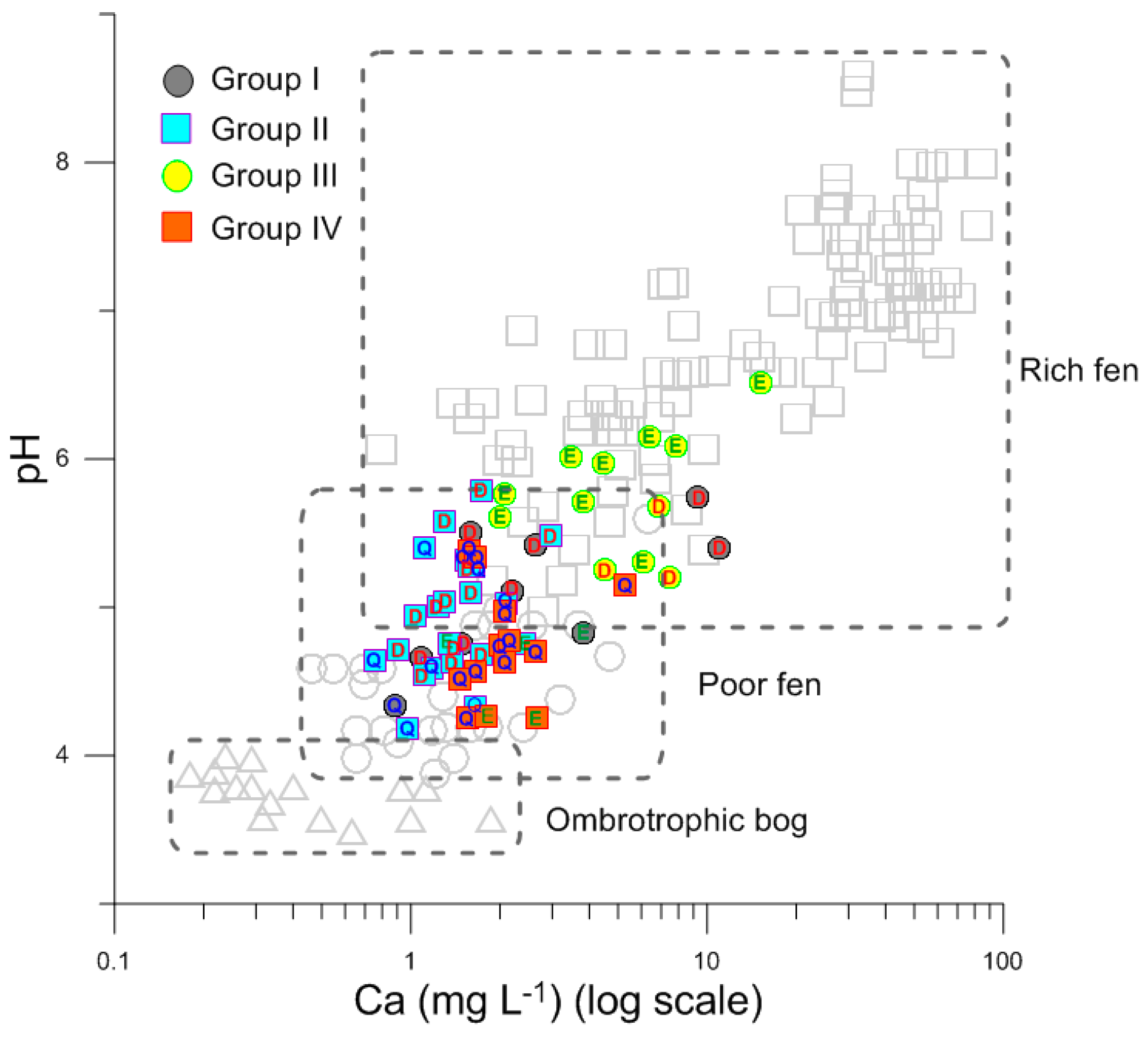
The dominance of Sphagnum in vegetation communities can be an indicator of nutrient-poor conditions [8]. Water pH and Ca concentration of our sampling points were higher than those of ombrotrophic bogs [4], generally approaching the characteristics of poor fens. The three peatlands in our study can be therefore mainly assigned as poor fens, with some partial sampling points being transitional types of poor fens and rich fens, and seven samples belong to rich fens (Figure 5). Sample sites suffering from Sphagnum harvest (Group III) demonstrated the characteristics of rich fens. This is because Sphagnum harvest can increase the exposure of peat, which causes peat decomposition, resulting in high nutrient and cation concentrations [18].
The major cation levels of water samples showed marked differences among peatlands, lakes and rivers in the Yangtze basin. High concentrations of major cations in rivers and lakes in the Yangtze basin can be attributed to weathering processes of carbonate-rich bedrock in the upper reach [29], as well as a large influx of anthropogenic nutrients, such as agricultural and domestic sewage [23,30,31]. Compared with rivers and lakes in the Yangtze basin, peatlands are deficient in major cations, probably resulting from the less input of cation-enriched underground and surface runoff, as well as the cation exchange by Sphagnum plants [4,8].
For trace elements, samples from peatlands, rivers and lakes demonstrated some overlaps in As and Zn. Relatively high concentrations of Zn in peatland samples (mean = 0.27 mg L−1) indicated that the study area was Zn rich. Similarly, it is found that the study region had relatively high basal contents of Zn in the soil [32]. Seven samples with Zn concentration above 1 mg L−1 were probably influenced by the influx of Zn-enriched groundwater and the relatively deficiency of Sphagnum to remove Zn compared with other metal ions (e.g., Pb, Cu, Ni, Cd) from mixed solutions [33]. High dissolved Zn concentration was also found in European and American peatlands, probably linked to anthropogenic emissions [34]. High As concentration could be linked to drying and re-wetting processes in peatlands, as drying- and rewetting-associated changes in redox status have the potential to increase As mobility [35]. As-enriched groundwater might be another reason for the high concentration of As in surface water, and this could reveal high background contents of As in this region. Low concentrations of Sr (mean = 16.5 μg L−1) in peatland waters reflected weak weathering processes in the study area [36].
4.2. Spatial Variations of Water Chemistry
Our study demonstrated large differences in water chemistry among the sampling points. Considering similar bedrock in the catchment and similar vegetation communities in the peatlands, the variations in water chemistry were probably linked to different anthropogenic disturbances. Samples from Group I were located near a road under construction and were thus likely influenced by metal pollutants in the dusts derived from road and gas combustion [17,19,23]. In addition, organic matter has a considerable adsorption capacity which can efficiently adsorb heavy metal ions [37]. Relatively higher concentrations of DOC in the nine samples (mean = 52.3 mg L−1) could enhance the accumulation of metal ions. Because Sphagnum plants possess a high cation exchange capacity, that is, to replace other cations (e.g., Ca, Na, K, and Mg) by H+, they contribute to the production of acidic conditions with low cation levels [38]. The samples from Group II were characterized by high acidity (low pH) and low major cations, probably resulting from the greater cation exchange capacity in these samples. Some samples from Group II were positively correlated with metal ions (Figure 3A), indicating the potential impacts of metal pollutants on peatlands.
In contrast, samples from Group III were characterized by high major cation levels and low acidity. 9 out of 12 samples in Group III were collected from EXY peatland, which had been suffering from conspicuous Sphagnum harvest. Overall low vegetation coverage on the harvested microsites may have permitted higher cation concentrations to remain available due to lack of consumption [7,32]. At the Seba Beach peatland, the exposure of peat caused significantly higher concentrations of major cations and nutrients compared to the neighboring natural sites [18]. Low redox potentials (mean = 286.4 mV) in samples from Group III were indicators of reductive conditions, probably promoting the solution of ferrous Fe and manganous Mn and their enrichment in these water samples [34]. The samples from Group IV were characterized by low concentrations of major cations and trace elements (except boron), indicating that these samples were less influenced by human disturbances. Actually, most samples (~85%) in Group IV came from QZMS peatland, which was classified as a natural reserve and thus subject to less anthropogenic disturbances. The mean values of water chemical components (except B) in Group IV can be regarded as reference conditions for restoration efforts in these peatlands. Boron (B), an essential nutrient for plant growth, is a rare element in the earth’s crust (≤10 mg kg−1) [39]. The reason for its high concentration in Group IV needs to be further explored.
4.3. Health Risk
In total, the mean health risk values of the six trace elements were much lower than the maximum allowance level recommended by ICRP. Between 2000 and 2007, 9189 ha of cultivated land was reforested due to ecological restoration in western Hubei Province [40]. This might contribute to the good water quality indicated by the lower health risk values in these peatlands. However, recent human activities, such as Sphagnum harvest, road construction, and agricultural sewage, have accelerated the enrichment of trace elements in these peatlands, and thus increased the health risk from drinking water for local inhabitants as well as the public in the lower reaches.
4.4. Conclusions and Implications for Peatland Conservation
This study is the first detailed report of water chemistry in the subtropical peatlands (central China), providing baseline information for the environmental assessment of these important ecoregions. Water pH and Ca concentration in most sampling points in three peatlands showed features of poor fens, but some sites approached categorization as rich fens, especially those sites with obvious Sphagnum harvest. Natural processes and anthropogenic disturbances were considered to be linked with the spatial variations of water chemistry in these peatlands. Based on the gradients of metal pollution and nutrient enrichment suggested by the PCA results, 57 sampling points can be clustered into four groups. Samples in Group I and Group III were mainly affected by human activities such as road construction and Sphagnum harvest. Cation exchange of Sphagnum explained the low pH and low major cation concentrations in Group II. Samples from Group IV were less disturbed by human activities, and can be regarded as reference sites for environmental restoration. Overall, the water quality of the three peatlands is good, as the health risk values of six trace elements are lower than the maximum allowance levels recommended by ICRP.
Despite the low health risk, effective measurements are urgently required to protect these ecologically important wetlands. First, strict regulations should be executed, such as prohibiting Sphagnum harvest, limiting visitor volumes, reducing impacts of agriculture, and building sewage treatment plants. Second, Sphagnum restoration in the harvested sites is strongly recommended, because Sphagnum plants are effective absorbents with strong water purification abilities [37]. Third, the average concentrations of trace elements (except B) in Group IV can be regarded as reference conditions for restoration efforts. Ongoing water monitoring is necessary to provide information on the dynamics of the water quality for the sustainable management of these scarce montane peatlands as well as other similar peatlands that are subject to human disturbances.
Supplementary Materials
The following are available online at www.mdpi.com/2073-4441/9/7/505/s1, Table S1: Sample code, location, dominant vegetation of 57 sampling points. Dajiuhu Peatland, Qizimeishan Peatland, and Erxianyan Peatland are coded D, Q, E, respectively; Table S2: Twenty-seven environmental parameters of 57 sampling points; Table S3: Health risk values (a−1) of six trace elements in 57 samples.
Acknowledgments
We are grateful to Jingze Ma, Yuxin Zhu, Yilan Liu and Yi Gong for field and laboratory assistance, and many thanks to five anonymous reviewers for their constructive comments and suggestions. This study was supported by the National Natural Science Fund of China (Grant Number: 41572343; 41402307), the Fundamental Research Funds for National University, China University of Geosciences (Wuhan) (Grant Number: G1323511656) and the Fundamental Research Funds for the Central Universities, South-Central University for Nationalities (Grant Number: CZQ14019).
Author Contributions
This study was designed by Xu Chen and Yanmin Cao. The field work was conducted with the association of Zhaojun Bu and Linghan Zeng. Linghan Zeng performed the laboratory analyses. Yanmin Cao and Xu Chen analyzed the data. The manuscript was prepared by Yanmin Cao and Xu Chen, and was revised by Zhaojun Bu.
Conflicts of Interest
The authors declare no conflict of interest.
References
- Martini, P.; Cortizas, A.M.; Chesworth, W. Peatlands: Evolution and Records of Environmental and Climate Changes (Vol. 9); Elsevier: Amsterdam, The Netherlands, 2007; pp. 17–51. [Google Scholar]
- Joosten, H.; Clarke, D. Wise Use of Mires and Peatlands; International Peat Society: Saarijärvi, Finland, 2002. [Google Scholar]
- Moore, P.D. The future of cool temperate Bogs. Environ. Conserv. 2002, 29, 3–20. [Google Scholar] [CrossRef]
- Sjörs, H.; Gunnarsson, U. Calcium and pH in north and central Swedish mire waters. J. Ecol. 2002, 90, 650–657. [Google Scholar] [CrossRef]
- Mitsch, W.J.; Gosselink, J.G. Wetlands; Wiley: New York, NY, USA, 2007. [Google Scholar]
- Vitt, D.H.; Bayley, S.E.; Jin, T.L. Seasonal variation in water chemistry over a bog-rich fen gradient in Continental Western Canada. Can. J. Fish. Aquat. Sci. 1995, 52, 587–606. [Google Scholar] [CrossRef]
- Bourbonniere, R.A. Review of water chemistry research in natural and disturbed peatlands. Can. Water Resour. J. 2009, 34, 393–414. [Google Scholar] [CrossRef]
- Rydin, H.; Jeglum, J.K. The Biology of Peatlands, 2nd ed.; Oxford University Press: Oxford, OH, USA, 2013. [Google Scholar]
- Chai, X. Peatland; Geological Publishing House: Beijing, China, 1990. (In Chinese) [Google Scholar]
- Du, Y.; Cai, S.M.; Wang, X.L.; He, B.Y.; Xu, G.L.; Jiang, M.X.; Xue, H.P.; Xiao, F. Enivironmental background and ecological restoration of the Dajiuhu sub-alpine wetland in Mt. Shennongjia. Res. Environ. Yangtze Basin 2008, 17, 915–919. [Google Scholar]
- Zhao, S.; Li, E.; Cai, X.; Wang, X.; Jiang, L.; Yan, R. Research on the higher plant diversity of subalpine Sphagnum mire in western Hubei Province, China. Res. Environ. Yangtze Basin 2013, 22, 468–475. [Google Scholar]
- Pan, X.B.; He, Y.; Yan, M.; Ji, Z.H.; Li, T.; Yan, R.K.; Zhou, C.Z.; Wang, J.M. Analysis on current situation of hydrology and water resources and protection measures of Dajiu Lake in Shenlongjia. Hubei Agric. Sci. 2013, 52, 3033–3037. [Google Scholar] [CrossRef]
- Chen, X.; Qin, Y.; Stevenson, M.A.; McGowan, S. Diatom communities along pH and hydrological gradients in three montane mires, central China. Ecol. Indic. 2014, 45, 123–129. [Google Scholar] [CrossRef]
- Huang, L.; Bai, J.; Xiao, R.; Gao, H.; Liu, P. Spatial distribution of Fe, Cu, Mn in the surface water system and their effects on wetland vegetation in the Pearl River Estuary of China. Clean–Soil Air Water 2012, 40, 1085–1092. [Google Scholar] [CrossRef]
- Zhang, L.; Shao, H. Heavy metal pollution in sediments from aquatic ecosystems in China. Clean-Soil Air Water 2013, 41, 878–882. [Google Scholar] [CrossRef]
- Shao, H.B.; Cui, B.S.; Bai, J.H. Wetland ecology in China. Clean-Soil Air Water 2012, 40, 1011–1014. [Google Scholar] [CrossRef]
- Cillero, C.; Díaz-Varela, R.A.; Rubinos, M.; Ramil-Rego, P. Assessment of anthropogenic pressures on South European Atlantic Bogs (NW Spain) based on hydrochemical data. Hydrobiologia 2016, 774, 137–154. [Google Scholar] [CrossRef]
- Wind-Mulder, H.L.; Vitt, D.H. Comparisons of water and peat chemistries of a post-harvested and undisturbed peatland with relevance to restoration. Wetlands 2000, 20, 616–628. [Google Scholar] [CrossRef]
- Santelmann, M.V.; Gorham, E. The influence of airborne road dust on the chemistry of Sphagnum mosses. J. Ecol. 1988, 76, 1219–1231. [Google Scholar] [CrossRef]
- Olson, D.M.; Dinerstein, E. The Global 200: A representation approach to conserving the Earth’s most biologically valuable ecoregions. Conserv. Biol. 1998, 12, 502–515. [Google Scholar] [CrossRef]
- Wang, Z.X.; Lei, Y.; Liu, S.X.; Fang, Y.P.; Man, J.S.; Peng, Z.L.; Zhang, L.; Ma, G.L. One subalpine sphagnum wetland being discovered in Qizimei Mountains Nature Reserve, Hubei. J. Cent. China Norm. Univ. (Nat. Sci.) 2005, 39, 387–388. [Google Scholar]
- Zhao, Y.; Yu, Z.; Tang, Y.; Li, H.; Yang, B.; Li, F.; Zhao, W.; Sun, J.; Chen, J.; Li, Q.; et al. Peatland initiation and carbon accumulation in China over the last 50,000 years. Earth-Sci. Rev. 2014, 128, 139–146. [Google Scholar] [CrossRef]
- Zeng, L.; Ning, D.; Xu, L.; Mao, X.; Chen, X. Sedimentary evidence of environmental degradation in Sanliqi Lake, Daye City (a typical mining city, central china). Bull. Environ. Contam. Toxicol. 2015, 95, 317–324. [Google Scholar] [CrossRef] [PubMed]
- Turner, T.E.; Billett, M.F.; Baird, A.J.; Chapman, P.J.; Dinsmore, K.J.; Holden, J. Regional variation in the biogeochemical and physical characteristics of natural peatland pools. Sci. Total Environ. 2016, 545, 84–94. [Google Scholar] [CrossRef] [PubMed]
- Ter Braak, C.; Šmilauer, P. CANOCO Reference Manual and CanoDraw for Windows User’s Guide: Software for Canonical Community Ordination (Version 4.5); Section on Permutation Methods; Microcomputer Power: Ithaca, NY, USA, 2002. [Google Scholar]
- Dean, J.F.; Billett, M.F.; Baxter, R.; Dinsmore, K.J.; Lessels, J.S.; Street, L.E.; Subke, J.-A.; Tetzlaff, D.; Washbourne, I.; Wookey, P.A. Biogeochemistry of “pristine” freshwater stream and lake systems in the western Canadian Arctic. Biogeochemistry 2016, 130, 191–213. [Google Scholar] [CrossRef]
- Hammer, Ø.; Harper, D.A.T.; Ryan, P.D. PAST: Paleontological Statistics Software Package for Education and Data Analysis. Palaeontol. Electron. 2001, 4, 9. [Google Scholar]
- USEPA. Quality Criteria for Water; US Department of Commerce, National Technical Information Service, United States Environmental Protection Agency (USEPA): Springfield, VA, USA, 1986.
- Müller, B.; Berg, M.; Yao, Z.P.; Zhang, X.F.; Wang, D.; Pfluger, A. How polluted is the Yangtze river? Water quality downstream from the Three Gorges Dam. Sci. Total Environ. 2008, 402, 232–247. [Google Scholar] [CrossRef]
- Liu, H.; Li, W. Dissolved trace elements and heavy metals from the shallow lakes in the middle and lower reaches of the Yangtze River region, China. Environ. Earth Sci. 2011, 62, 1503–1511. [Google Scholar] [CrossRef]
- Wu, J.; Zeng, H.; Yu, H.; Ma, L.; Xu, L.; Qin, B. Water and sediment quality in lakes along the middle and lower reaches of the Yangtze River, China. Water Resour. Manag. 2012, 26, 3601–3618. [Google Scholar] [CrossRef]
- Mao, R.; Wang, Z.X.; Lei, Y.; Li, Z.Q.; Man, J.S.; Peng, Z.L. Profile characteristics and element vertical distribution in sphagnum wetland in Qizimei Mountains Nature Reserve, Hubei. Acta Pedol. Sin. 2009, 46, 159–163. [Google Scholar]
- Kalmykova, Y.; Strömvall, A.M.; Steenari, B.M. Adsorption of Cd, Cu, Ni, Pb and Zn on Sphagnum peat from solutions with low metal concentrations. J. Hazard. Mater. 2008, 152, 885–891. [Google Scholar] [CrossRef] [PubMed]
- Shotyk, W. Review of the inorganic geochemistry of peats and peatland waters. Earth Sci. Rev. 1988, 25, 95–176. [Google Scholar] [CrossRef]
- Rothwell, J.J.; Taylor, K.G.; Ander, E.L.; Evans, M.G.; Daniels, S.M.; Allott, T.E.H. Arsenic retention and release in ombrotrophic peatlands. Sci. Total Environ. 2009, 407, 1405–1417. [Google Scholar] [CrossRef] [PubMed]
- Xu, H.; Liu, B.; Wu, F. Spatial and temporal variations of Rb/Sr ratios of the bulk surface sediments in Lake Qinghai. Geochem. Trans. 2010, 11, 1–8. [Google Scholar] [CrossRef] [PubMed]
- He, W.; Zhang, Y.; Tian, R.; Hu, H.; Chen, B.; Chen, L.K.; Xu, F. Modeling the purification effects of the constructed Sphagnum wetland on phosphorus and heavy metals in Dajiuhu Wetland Reserve, China. Ecol. Model. 2013, 252, 23–31. [Google Scholar] [CrossRef]
- Clymo, R.S.; Hayward, P.M. The Ecology of Sphagnum. In Bryophyte Ecology; Smith, A.J.E., Ed.; Springer: Berlin, Germany, 1982; pp. 229–289. [Google Scholar]
- Stone, E.L. Boron deficiency and excess in forest trees: A review. Forest Ecol. Manag. 1990, 37, 49–75. [Google Scholar] [CrossRef]
- Deng, F.; Li, R.D.; Wang, H.F. Dynamic changes of cultivated land in Hubei Province from 2000 to 2007. Resour. Environ. Yangtze Basin 2010, 19, 1171–1176. [Google Scholar]
Figure 1.
Location of the three peatlands in the Yangtze basin.
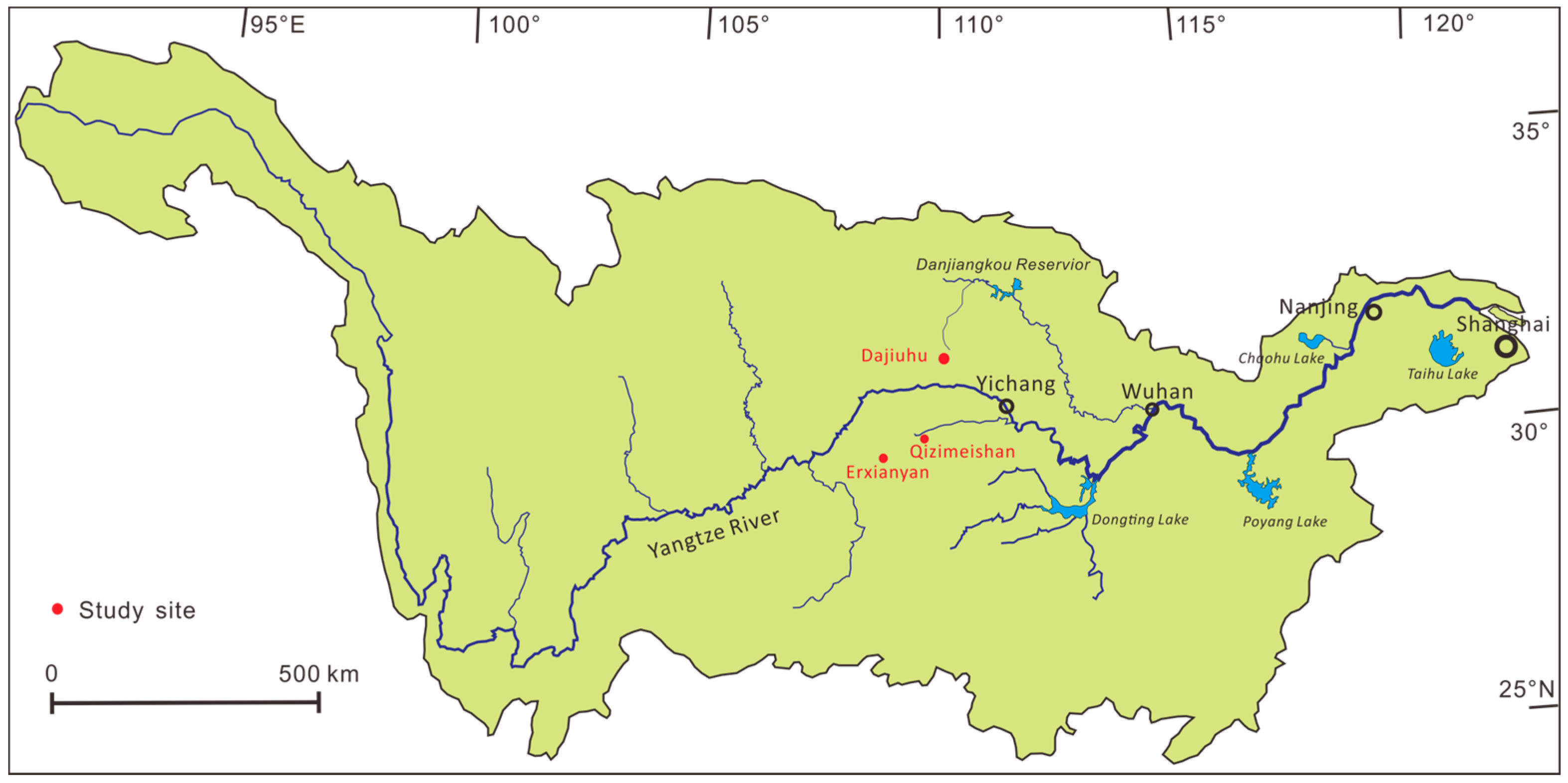
Figure 2.
Diagrams showing the difference among peatlands, rivers, and lakes based on (A) Ca, K+Na; (B) Zn and As; and (C) Sr and Mg. Water chemistry data of rivers and lakes in the Yangtze basin are cited from the References of [29,30,31].
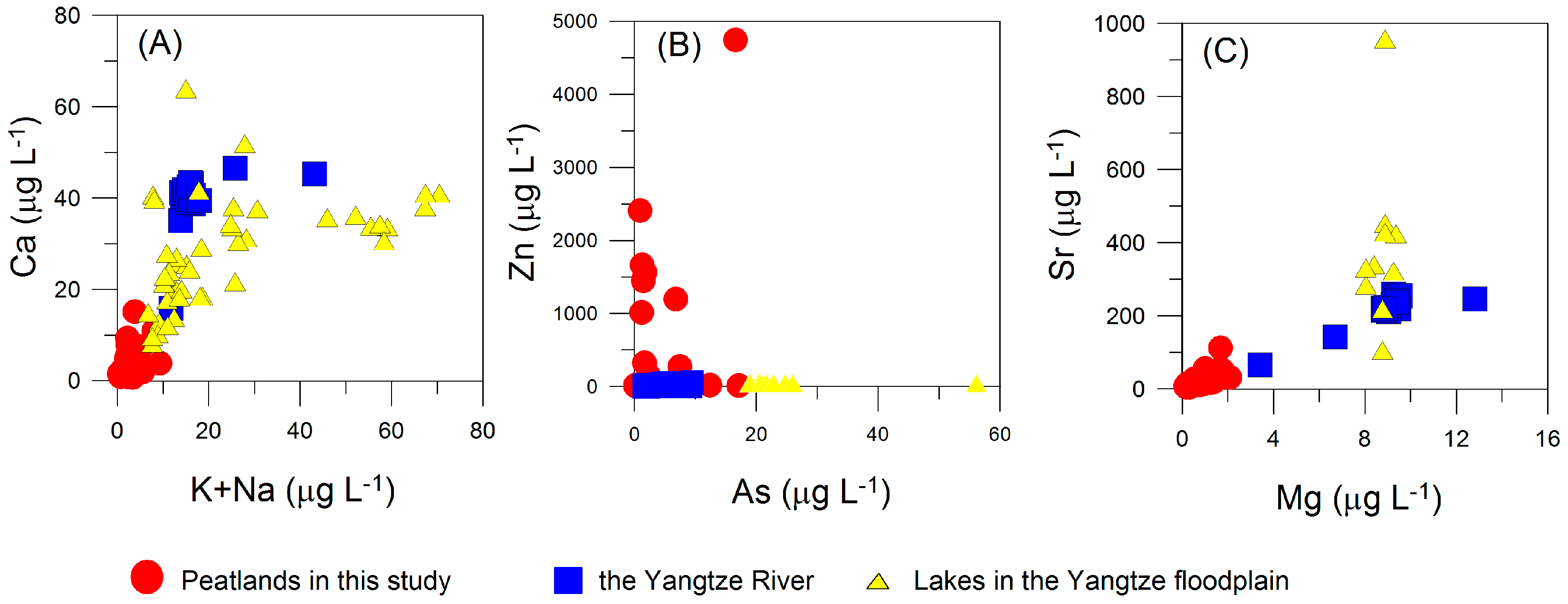
Figure 3.
(A) Principal component analysis (PCA) ordination diagram of samples based on environmental parameters; (B) cluster analysis of samples using the method of Ward’s minimum variance. The color code represents samples from DJH (D), QZMS (Q), and EXY (E), and the symbol code in (A) represents the four groups.
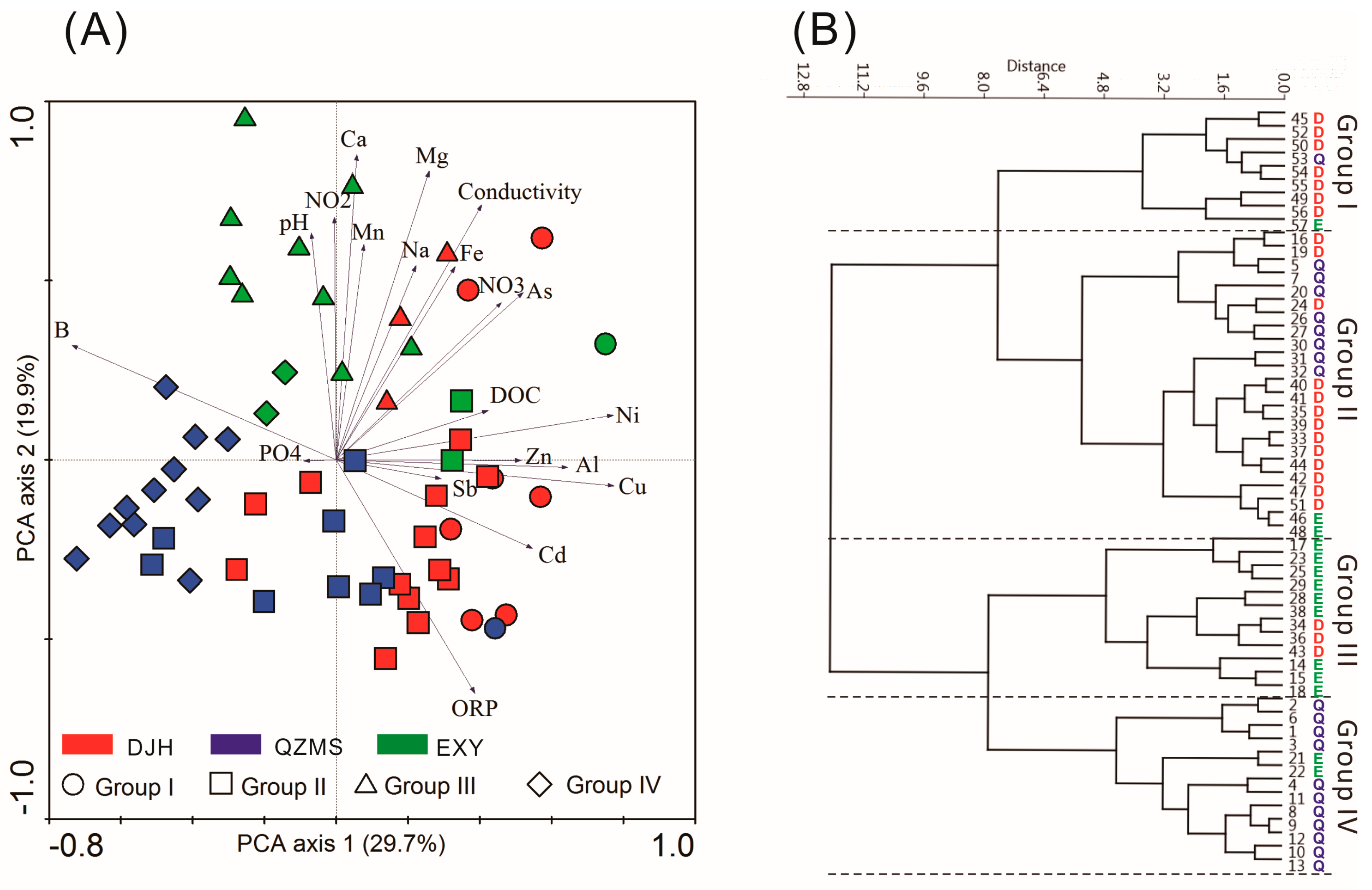
Figure 4.
Health risk values of six trace elements in 57 sampling points.
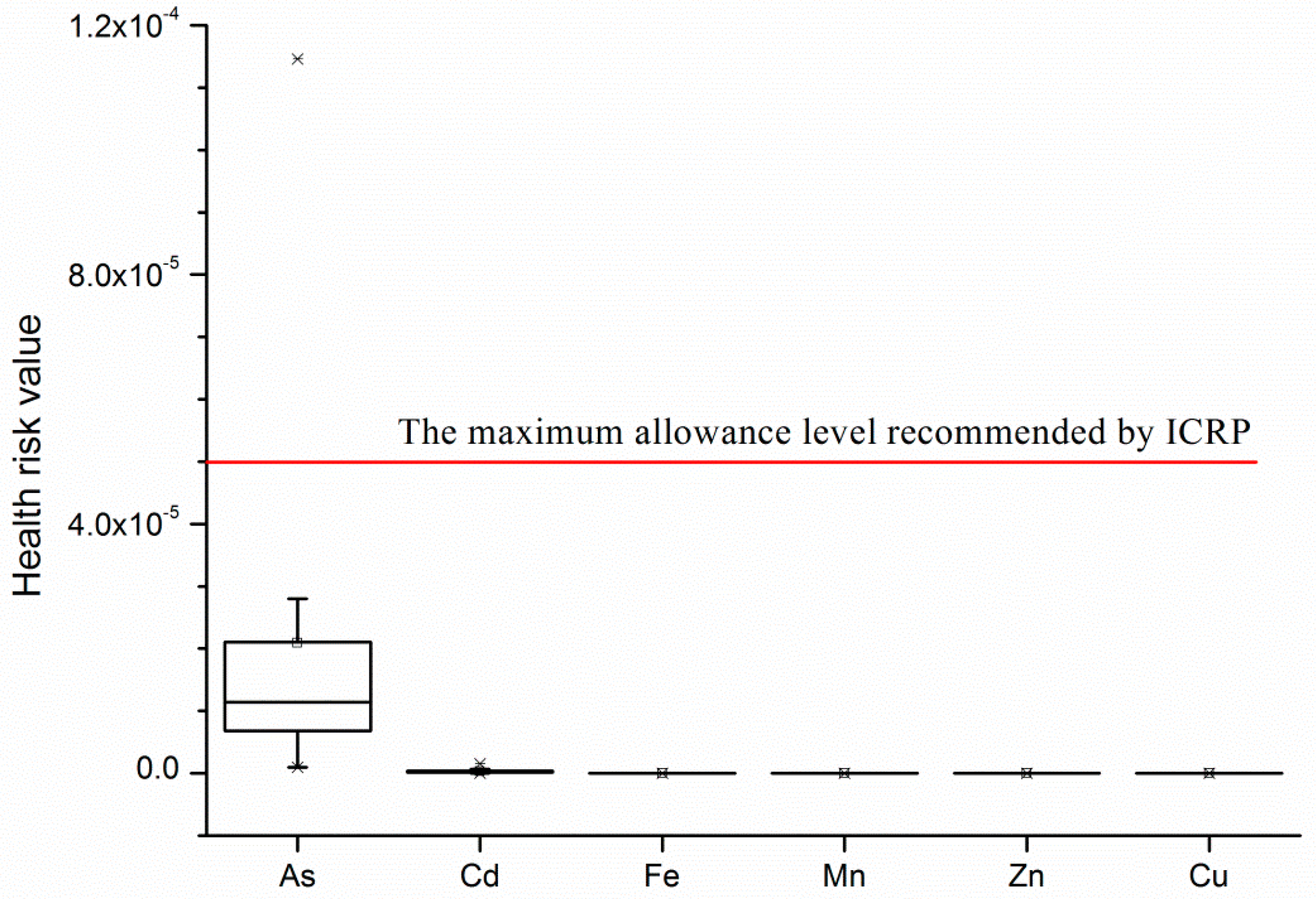
Figure 5.
Calcium concentrations and pH in water samples of the three peatlands (filled shapes) and their classification according to Sjőrs and Gunnarsson (2002) (non-filled shapes). D, Q and E represent sampling points from DJH, EXY and QZMS, respectively.
Figure 5.
Calcium concentrations and pH in water samples of the three peatlands (filled shapes) and their classification according to Sjőrs and Gunnarsson (2002) (non-filled shapes). D, Q and E represent sampling points from DJH, EXY and QZMS, respectively.


Table 1.
Mean values and standard deviations of each environmental variable in different groups. Variables significantly different among the groups are marked based on a Kruskal-Wallis test.
Table 1.
Mean values and standard deviations of each environmental variable in different groups. Variables significantly different among the groups are marked based on a Kruskal-Wallis test.
| Variable/Unit | Group I | Group II | Group III | Group IV | All | p-Value |
|---|---|---|---|---|---|---|
| (n = 9) | (n = 23) | (n = 12) | (n = 13) | (n = 57) | ||
| pH | 5.08 ± 0.46 | 4.95 ± 0.41 | 5.77 ± 0.40 | 4.73 ± 0.39 | 5.09 ± 0.55 | <0.001 |
| Cond./μS cm−1 | 30.3 ± 12.9 | 21.2 ± 7.6 | 55.8 ± 24.1 | 16.3 ± 9.8 | 28.8 ± 19.9 | <0.001 |
| ORP/mV | 393.5 ± 40.5 | 390.4 ± 49.5 | 286.4 ± 70.8 | 347.0 ± 22.2 | 359.1 ± 63.6 | <0.001 |
| DOC/mg L−1 | 52.3 ± 39.7 | 41.5 ± 40.2 | 36.3 ± 21.6 | 29.0 ± 20.8 | 39.3 ± 33.2 | 0.45 |
| NH4+/mg L−1 | 0.95 ± 0.96 | 0.82 ± 0.69 | 1.71 ± 0.78 | 0.71 ± 0.54 | 1.00 ± 0.80 | <0.01 |
| NO2−/μg L−1 | 10.74 ± 9.53 | 6.54 ± 3.51 | 28.51 ± 46.22 | 7.45 ± 3.81 | 12.03 ± 22.72 | <0.01 |
| NO3−/μg L−1 | 1672 ± 933 | 1163 ± 769 | 1691 ± 834 | 1209 ± 1051 | 1365 ± 889 | 0.16 |
| PO43−/μg L−1 | 16.04 ± 3.35 | 18.09 ± 10.77 | 16.14 ± 3.45 | 18.22 ± 2.58 | 17.39 ± 7.21 | <0.05 |
| K/mg L−1 | 1.97 ± 2.02 | 1.18 ± 0.74 | 2.09 ± 0.98 | 1.18 ± 0.87 | 1.50 ± 1.15 | <0.05 |
| Ca/mg L−1 | 3.78 ± 3.74 | 1.48 ± 0.50 | 5.85 ± 3.52 | 2.20 ± 1.01 | 2.92 ± 2.77 | <0.001 |
| Na/mg L−1 | 1.43 ± 1.74 | 0.92 ± 0.59 | 1.65 ± 0.82 | 0.78 ± 0.31 | 1.12 ± 0.92 | <0.01 |
| Mg/mg L−1 | 0.87 ± 0.72 | 0.36 ± 0.14 | 1.09 ± 0.43 | 0.41 ± 0.14 | 0.61 ± 0.47 | <0.001 |
| Fe/mg L−1 | 2.34 ± 3.34 | 1.06 ± 1.26 | 3.91 ± 4.54 | 1.22 ± 1.46 | 1.90 ± 2.83 | 0.37 |
| Mn/mg L−1 | 0.26 ± 0.31 | 0.08 ± 0.09 | 0.90 ± 1.03 | 0.10 ± 0.10 | 0.29 ± 0.58 | 0.14 |
| Si/mg L−1 | 1.50 ± 0.74 | 0.91 ± 0.62 | 1.75 ± 1.06 | 1.04 ± 0.53 | 1.21 ± 0.79 | <0.05 |
| Zn/mg L−1 | 1.51 ± 1.43 | 0.02 ± 0.01 | 0.12 ± 0.34 | 0.02 ± 0.01 | 0.27 ± 0.78 | <0.001 |
| B/μg L−1 | 4.0 ± 3.8 | 4.3 ± 5.5 | 37.0 ± 37.9 | 168.3 ± 103.0 | 48.6 ± 84.0 | <0.001 |
| Al/μg L−1 | 237.8 ± 201.5 | 179.2 ± 156.5 | 136.3 ± 124.7 | 122.6 ± 158.5 | 166.5 ± 159.3 | 0.32 |
| V/μg L−1 | 0.68 ± 0.80 | 0.52 ± 0.59 | 0.64 ± 0.90 | 0.36 ± 0.61 | 0.53 ± 0.69 | 0.20 |
| Co/μg L−1 | 1.25 ± 1.11 | 0.82 ± 0.54 | 2.52 ± 2.43 | 0.71 ± 0.48 | 1.21 ± 1.41 | 0.23 |
| Ni/μg L−1 | 1.90 ± 0.91 | 1.06 ± 0.52 | 1.27 ± 0.90 | 0.64 ± 0.28 | 1.14 ± 0.75 | <0.001 |
| Cu/μg L−1 | 80.7 ± 70.3 | 2.2 ± 1.6 | 1.3 ± 0.8 | 0.6 ± 0.5 | 14.0 ± 39.4 | <0.001 |
| As/μg L−1 | 3.84 ± 5.18 | 2.54 ± 2.69 | 5.03 ± 5.22 | 1.82 ± 1.83 | 3.11 ± 3.76 | 0.19 |
| Sr/μg L−1 | 21.1 ± 18.9 | 8.9 ± 3.2 | 32.2 ± 28.2 | 12.3 ± 5.7 | 16.5 ± 17.4 | <0.001 |
| Cd/μg L−1 | 0.16 ± 0.10 | 0.14 ± 0.12 | 0.06 ± 0.02 | 0.08 ± 0.05 | 0.11 ± 0.10 | <0.01 |
| Sb/μg L−1 | 1.42 ± 0.27 | 1.49 ± 0.26 | 1.42 ± 0.42 | 1.24 ± 0.45 | 1.41 ± 0.35 | 0.36 |
| Ba/μg L−1 | 26.3 ± 30.5 | 18.5 ± 18.4 | 34.1 ± 35.4 | 12.3 ± 8.0 | 21.6 ± 24.2 | 0.16 |
© 2017 by the authors. Licensee MDPI, Basel, Switzerland. This article is an open access article distributed under the terms and conditions of the Creative Commons Attribution (CC BY) license (http://creativecommons.org/licenses/by/4.0/).
Share and Cite
MDPI and ACS Style
Cao, Y.-M.; Chen, X.; Bu, Z.-J.; Zeng, L.-H. Spatial Variations in the Surface Water Chemistry of Subtropical Peatlands (Central China) Linked to Anthropogenic Pressures. Water 2017, 9, 505. https://doi.org/10.3390/w9070505
AMA Style
Cao Y-M, Chen X, Bu Z-J, Zeng L-H. Spatial Variations in the Surface Water Chemistry of Subtropical Peatlands (Central China) Linked to Anthropogenic Pressures. Water. 2017; 9(7):505. https://doi.org/10.3390/w9070505
Chicago/Turabian StyleCao, Yan-Min, Xu Chen, Zhao-Jun Bu, and Ling-Han Zeng. 2017. "Spatial Variations in the Surface Water Chemistry of Subtropical Peatlands (Central China) Linked to Anthropogenic Pressures" Water 9, no. 7: 505. https://doi.org/10.3390/w9070505
Note that from the first issue of 2016, this journal uses article numbers instead of page numbers. See further details here.