

Structural Control at Monte Somma and Vesuvio during the Last 5600 Years through Time and Space Distribution of Volcanic Vents

 ,
,  ,
,
Abstract
:1. Introduction
2. Stratigraphical Outline
3. Regional Tectonic Framework and Previous Structural and Morpho-Structural Studies
4. Methods and Results
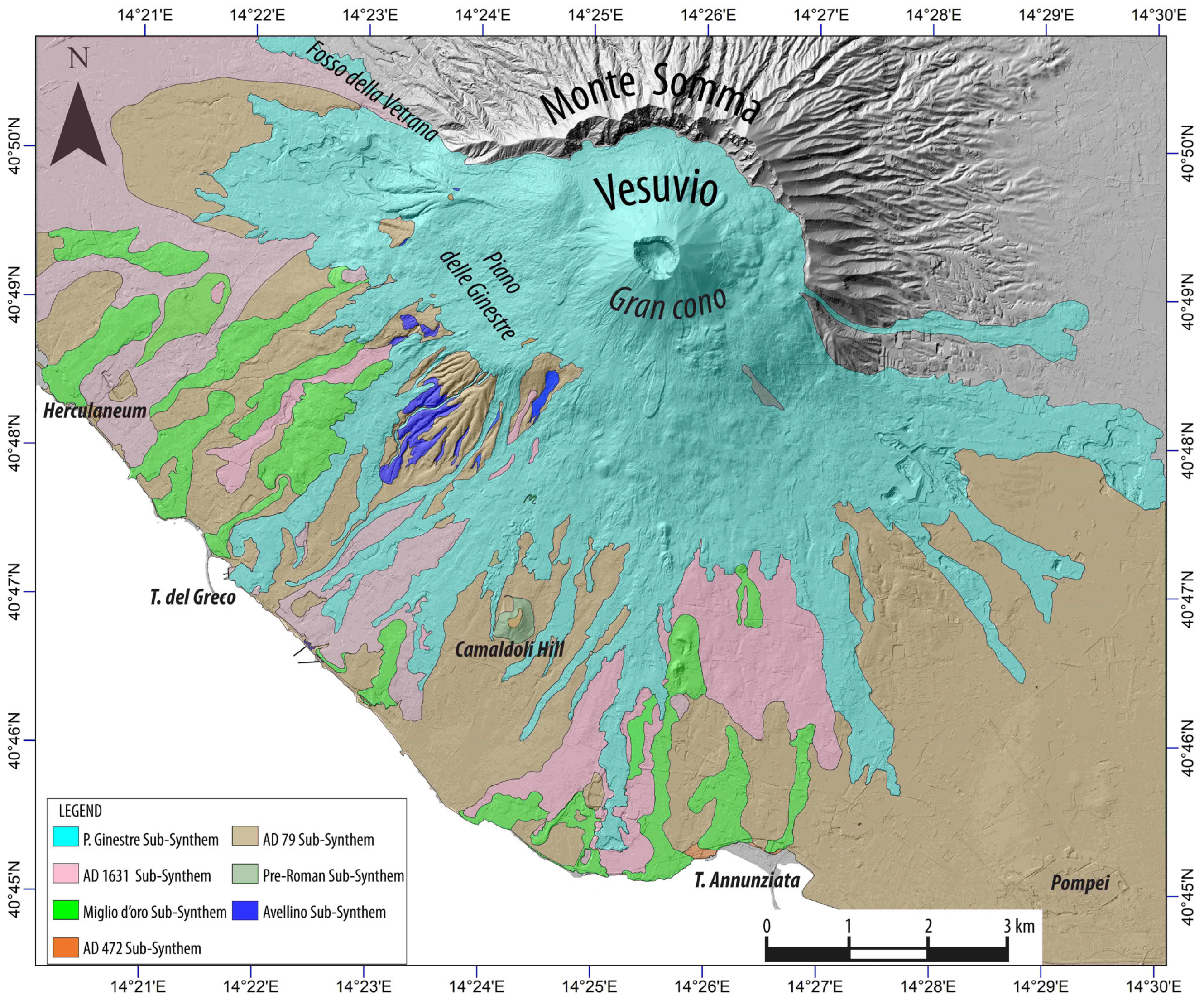
5. Distribution of Vents in Time and Space and Relationship with Structural Trends
5.1. Vents Formed during the Pre-Historic Vesuvius Synthem (4000 a BP–5600 a BP)
5.2. Vents Formed during the Proto Vesuvius Synthem (AD 79—4000 a BP)
5.3. Vents Formed during the Ancient Vesuvius Synthem (AD 472–AD 79)
5.4. Vents Formed during the Medieval Vesuvius Synthem (1139—AD 472)
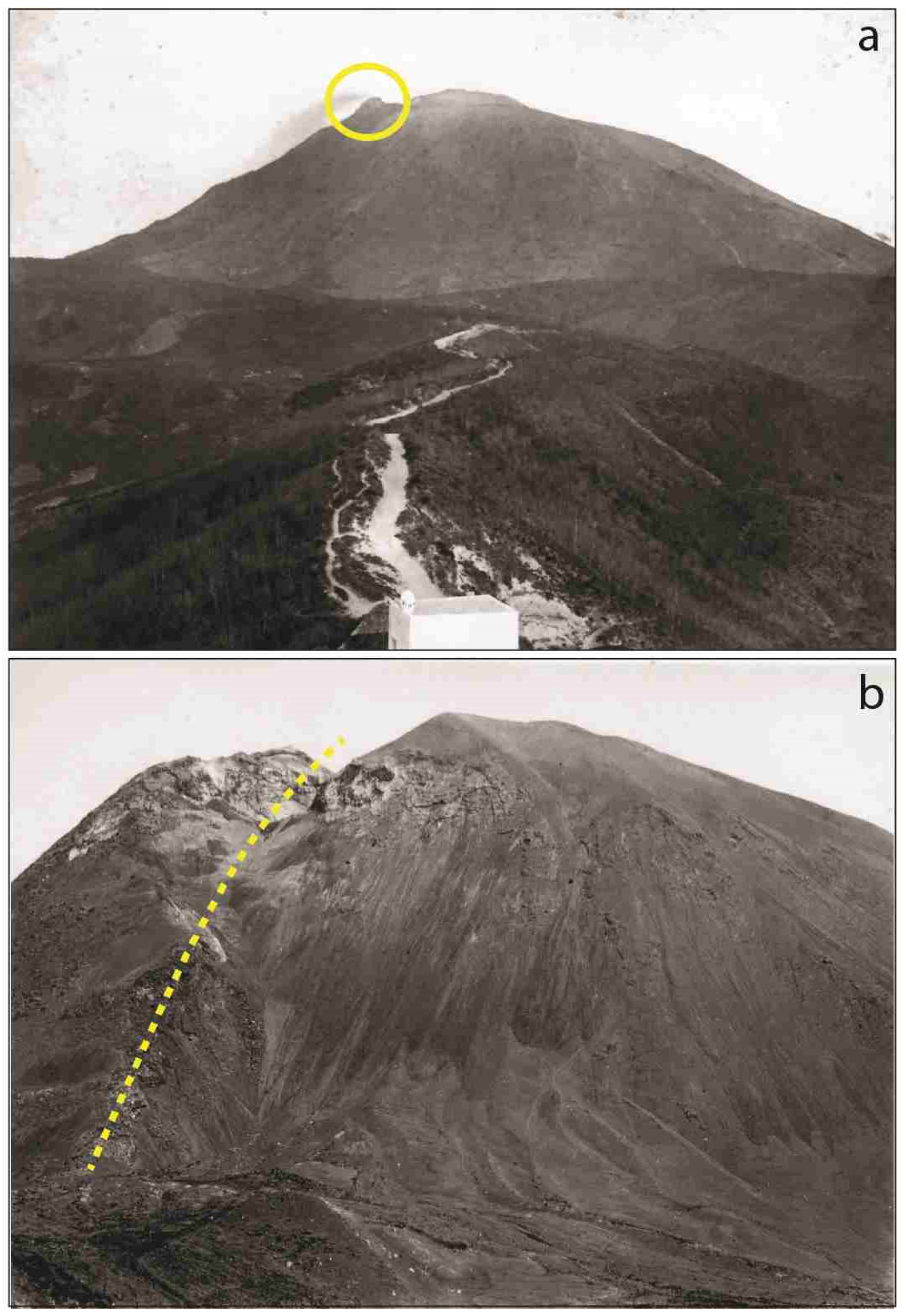
5.5. Vents Formed during the Present Vesuvius Synthem (1944–1631)
6. Discussion
7. Conclusions
Author Contributions
Funding
Data Availability Statement
Acknowledgments
Conflicts of Interest
Appendix A

| Vents | X Coordinate | Y Coordinate | Typology | Super-Synthem | Synthem | Sub-Synthem | Name/Locality | Assigned Age | References |
|---|---|---|---|---|---|---|---|---|---|
| 1 | 441678.8639 | 4512546.465 | undersea cryptodome | Gulf of Naples | <19,000 y BP | Milia et al., 1998 [31] | |||
| 2 | 442228.1 | 4512121.49 | off-shore vent | Gulf of Naples | unknown | Finetti & Morelli 1974 [20] | |||
| 3 | 442806.87 | 4511708.08 | off-shore vent | Gulf of Naples | unknown | Finetti & Morelli 1974 [20] | |||
| 4 | 443036.1791 | 4511263.233 | undersea cryptodome | Gulf of Naples | <19,000 y BP | Milia et al., 1998 [31] | |||
| 5 | 444094.5146 | 4511355.837 | undersea cryptodome | Gulf of Naples | <19,000 y BP | Milia et al., 1998 [31] | |||
| 6 | 444575.3957 | 4510142.72 | undersea cryptodome | Gulf of Naples | <19,000 y BP | Milia et al., 1998 [31] | |||
| 7 | 444646.5468 | 4512941.136 | off-shore vent | Gulf of Naples | <19,000 y BP | Aiello et al., 2010 [32]; Paoletti et al., 2016 [33] | |||
| 8 | 445003.735 | 4511978.051 | off-shore vent | Gulf of Naples | <19,000 y BP | Aiello et al., 2010 [32]; Paoletti et al., 2016 [33] | |||
| 9 | 445049 | 4514522.02 | undersea pit crater | Gulf of Naples | unknown | Milia et al., 1998 [31] | |||
| 10 | 445651.9655 | 4511358.925 | off-shore vent | Gulf of Naples | <19,000 y BP | Paoletti et al., 2016 [33] | |||
| 11 | 446168.871 | 4517267.602 | inferred vent | Vesuvio | Medieval Vesuvius | Miglio d’Oro | Favorita | 9th−10th century | Paolillo et al., 2016 [17] |
| 12 | 446423.311 | 4524520.8 | spatter cone | Proto Somma | Trapolino | Cercola/Masseria San Giovanni | 39,000–22,000 y BP | Johnston-Lavis 1884 [57], this work | |
| 13 | 446627.7554 | 4509801.272 | off-shore vent | Gulf of Naples | <19,000 y BP | Aiello et al., 2010 [32]; Paoletti et al., 2016 [33] | |||
| 14 | 446928.46 | 4516303.66 | spatter cone | Vesuvio | Medieval Vesuvius | Miglio d’Oro | Calastro | 9th−10th century | Paolillo et al., 2016 [17] |
| 15 | 447240.95 | 4517461.78 | spatter cone | Vesuvio | Medieval Vesuvius | Miglio d’Oro | I Tironi | 1006–07 | Paolillo et al., 2016 [17] |
| 16 | 447432.66 | 4517463.43 | spatter cone | Vesuvio | Medieval Vesuvius | Miglio d’Oro | I Tironi | 1006–07 | Paolillo et al., 2016 [17] |
| 17 | 447610.26 | 4517160.78 | inferred vent | Vesuvio | Medieval Vesuvius | Miglio d’Oro | I Tironi | 1006–07 | Paolillo et al., 2016 [17] |
| 18 | 447662.73 | 4519361.85 | lava cumulus | Vesuvio | Present Vesuvius | Piano delle Ginestre | Novelle di Scappa | 1858 | Paolillo et al., 2016 [17] |
| 19 | 447666.21 | 4519677.42 | lava cumulus | Vesuvio | Present Vesuvius | Piano delle Ginestre | Novelle di Scappa | 1858 | This work |
| 20 | 447696.3 | 4518866.16 | covered vent | Vesuvio | Medieval Vesuvius | Miglio d’Oro | Sotto i Troni/Novelle di San Vito | 9th−10th century | Paolillo et al., 2016 [17] |
| 21 | 447788.31 | 4513637.83 | spatter cone | Vesuvio | Proto Vesuvius | Pre-Roman | Torre Bassano | AD 79–4000 y BP | Di Girolamo 1970 [54]; Paolillo et al., 2016 [17] |
| 22 | 447805.1536 | 4511195.629 | off-shore vent | Gulf of Naples | <19,000 y BP | Aiello et al., 2010 [32]; Paoletti et al., 2016 [33] | |||
| 23 | 447834.3 | 4519030.09 | lava cumulus | Vesuvio | Present Vesuvius | Piano delle Ginestre | Novelle di San Vito | 1858 | Paolillo et al., 2016 [17] |
| 24 | 447835.73 | 4513580.94 | spatter cone | Vesuvio | Proto Vesuvius | Pre-Roman | Torre Bassano | AD 79–4000 y BP | Di Girolamo 1970 [54]; Paolillo et al., 2016 [17] |
| 25 | 447839.67 | 4520295.24 | spatter cone | Proto Somma | Trapolino | Case Sorrentino | 22,000–19,200 y BP | Brocchini 1999 [34] | |
| 26 | 447958.69 | 4519418.09 | lava cumulus | Vesuvio | Present Vesuvius | Piano delle Ginestre | Novelle di Scappa | 1858 | This work |
| 27 | 447990.16 | 4519194.7 | lava cumulus | Vesuvio | Present Vesuvius | Piano delle Ginestre | Novelle di San Vito | 1858 | Paolillo et al., 2016 [17] |
| 28 | 448138.58 | 4519206.52 | lava cumulus | Vesuvio | Present Vesuvius | Piano delle Ginestre | Novelle di San Vito | 1858 | Paolillo et al., 2016 [17] |
| 29 | 448202.95 | 4517736.81 | spatter cone | Vesuvio | Present Vesuvius | Piano delle Ginestre | Montedoro | 1794 | Rosi et al., 1986 [2]; Paolillo et al., 2016 [17] |
| 30 | 448209.42 | 4519052.94 | lava cumulus | Vesuvio | Present Vesuvius | Piano delle Ginestre | Novelle di San Vito | 1858 | Paolillo et al., 2016 [17] |
| 31 | 448266.51 | 4517219.6 | spatter cone | Vesuvio | Present Vesuvius | Piano delle Ginestre | Montedoro | 1861 | Rosi et al., 1986 [2]; Paolillo et al., 2016 [17] |
| 32 | 448308.62 | 4517240.07 | spatter cone | Vesuvio | Present Vesuvius | Piano delle Ginestre | Montedoro | 1861 | Rosi et al., 1986 [2]; Paolillo et al., 2016 [17] |
| 33 | 448361.9 | 4517259.82 | spatter cone | Vesuvio | Present Vesuvius | Piano delle Ginestre | Montedoro | 1861 | Rosi et al., 1986 [2]; Paolillo et al., 2016 [17] |
| 34 | 448365.13 | 4514499.76 | inferred vent | Vesuvio | Medieval Vesuvius | Miglio d’Oro | Torre Bassano/L’Epitaffio | 968 BC | Paolillo et al., 2016 [17] |
| 35 | 448393.14 | 4518889.7 | lava cumulus | Vesuvio | Present Vesuvius | Piano delle Ginestre | Piano delle Ginestre | 1858 | Paolillo et al., 2016 [17] |
| 36 | 448399.07 | 4517976.71 | spatter cone | Vesuvio | Present Vesuvius | Piano delle Ginestre | Montedoro | 1794 | Rosi et al., 1986 [2]; Paolillo et al., 2016 [17] |
| 37 | 448461.57 | 4518019.46 | spatter cone | Vesuvio | Present Vesuvius | Piano delle Ginestre | Montedoro | 1794 | Rosi et al., 1986 [2]; Paolillo et al., 2016 [17] |
| 38 | 448490.34 | 4517313.3 | spatter cone | Vesuvio | Present Vesuvius | Piano delle Ginestre | Montedoro | 1861 | Rosi et al., 1986 [2]; Paolillo et al., 2016 [17] |
| 39 | 448539.77 | 4518062.81 | spatter cone | Vesuvio | Present Vesuvius | Piano delle Ginestre | Montedoro | 1794 | Rosi et al., 1986 [2]; Paolillo et al., 2016 [17] |
| 40 | 448555.28 | 4517340.79 | spatter cone | Vesuvio | Present Vesuvius | Piano delle Ginestre | Montedoro | 1861 | Rosi et al., 1986 [2]; Paolillo et al., 2016 [17] |
| 41 | 448562.09 | 4518962.98 | lava cumulus | Vesuvio | Present Vesuvius | Piano delle Ginestre | Piano delle Ginestre | 1858 | Paolillo et al., 2016 [17] |
| 42 | 448566.83 | 4518075.91 | spatter cone | Vesuvio | Present Vesuvius | Piano delle Ginestre | Montedoro | 1794 | Rosi et al. 1986 [2]; Paolillo et al., 2016 [17] |
| 43 | 448627.82 | 4517396.22 | spatter cone | Vesuvio | Present Vesuvius | Piano delle Ginestre | Montedoro | 1861 | Rosi et al., 1986 [2]; Paolillo et al., 2016 [17] |
| 44 | 448706.49 | 4517448.91 | spatter cone | Vesuvio | Present Vesuvius | Piano delle Ginestre | Montedoro | 1861 | Rosi et al., 1986 [2]; Paolillo et al., 2016 [17] |
| 45 | 448724.33 | 4519353 | lava cumulus | Vesuvio | Present Vesuvius | Piano delle Ginestre | Piano delle Ginestre | 1858 | Paolillo et al., 2016 [17] |
| 46 | 448748.29 | 4519486.13 | lava cumulus | Vesuvio | Present Vesuvius | Piano delle Ginestre | Piano delle Ginestre | 1858 | This work |
| 47 | 448780.85 | 4517494.39 | spatter cone | Vesuvio | Present Vesuvius | Piano delle Ginestre | Montedoro | 1861 | Rosi et al., 1986 [2]; Paolillo et al., 2016 [17] |
| 48 | 448813.74 | 4519405.35 | lava cumulus | Vesuvio | Present Vesuvius | Piano delle Ginestre | Piano delle Ginestre | 1858 | This work |
| 49 | 448948.89 | 4521815.89 | spatter cone | Somma | Cognoli di Ottaviano | Canale dell’Arena | Pollena Quarry | 22,000–19,200 y BP | Rosi et al. 1986 [2]; this work |
| 50 | 449012.39 | 4521752.39 | spatter cone | Proto Somma | Trapolino | Pollena Quarry | 39,000–22,000 y BP | Rosi et al., 1986 [2]; this work | |
| 51 | 449162.87 | 4518099.51 | spatter cone | Vesuvio | Present Vesuvius | Piano delle Ginestre | Piano delle Ginestre | 1794 | Rosi et al., 1986 [2]; Paolillo et al., 2016 [17] |
| 52 | 449225.22 | 4518134.47 | spatter cone | Vesuvio | Present Vesuvius | Piano delle Ginestre | Piano delle Ginestre | 1794 | Rosi et al., 1986 [2]; Paolillo et al., 2016 [17] |
| 53 | 449247.07 | 4519178.75 | covered vent | Vesuvio | Present Vesuvius | Piano delle Ginestre | Piano delle Ginestre | 1858 | Paolillo et al., 2016 [17] |
| 54 | 449253.69 | 4519308.21 | lava cumulus | Vesuvio | Present Vesuvius | Piano delle Ginestre | Piano delle Ginestre | 1858 | Paolillo et al., 2016 [17] |
| 55 | 449349.48 | 4518156.97 | covered vent | Vesuvio | Present Vesuvius | Piano delle Ginestre | Piano delle Ginestre | 1794 | Rosi et al., 1986 [2]; Paolillo et al., 2016 [17] |
| 56 | 449462.52 | 4519511.37 | covered vent | Vesuvio | Present Vesuvius | Piano delle Ginestre | Piano delle Ginestre | 1858 | Allievi 1875 (Tav.5) [40]; this work |
| 57 | 449492.31 | 4518683.72 | central vent | Vesuvio | Proto Vesuvius | Avellino | Avellino tuff-cone/Piano delle Ginestre | 4000 y BP | Principe et al., 2021 [56] |
| 58 | 449599.9 | 4518232.51 | spatter cone | Vesuvio | Present Vesuvius | Piano delle Ginestre | Piano delle Ginestre | 1794 | Rosi et al., 1986 [2]; Paolillo et al., 2016 [17] |
| 59 | 449817 | 4514547.44 | cinder cone | Vesuvio | Proto Vesuvius | Pre-Roman | Camaldoli della Torre | AD 79–4000 y BP | Rosi et al., 1986 [2]; Paolillo et al., 2016 [17] |
| 60 | 450010.59 | 4518508.78 | lava cumulus | Vesuvio | Present Vesuvius | Piano delle Ginestre | Piano delle Ginestre | 1858 | Paolillo et al., 2016 [17] |
| 61 | 450075.8 | 4518642.97 | lava cumulus | Vesuvio | Present Vesuvius | Piano delle Ginestre | Piano delle Ginestre | 1858 | Paolillo et al., 2016 [17] |
| 62 | 450140.05 | 4518492.72 | lava cumulus | Vesuvio | Present Vesuvius | Piano delle Ginestre | Piano delle Ginestre | 1858 | Paolillo et al., 2016 [17] |
| 63 | 450285.57 | 4518744.08 | covered vent | Vesuvio | Present Vesuvius | Piano delle Ginestre | Piano delle Ginestre | 1858 | Paolillo et al., 2016 [17] |
| 64 | 450388.08 | 4519188.24 | lava cumulus | Vesuvio | Present Vesuvius | Piano delle Ginestre | Gran Cono | 1858 | Paolillo et al., 2016 [17] |
| 65 | 450398.35 | 4519277.82 | covered vent | Vesuvio | Present Vesuvius | Piano delle Ginestre | Gran Cono | 1858 | Allievi 1875 (Tav.4) [40]; this work |
| 66 | 450457.89 | 4519751.32 | lava cumulus | Vesuvio | Present Vesuvius | Piano delle Ginestre | Colle Umberto | 1895–99 | Rosi et al., 1986 [2]; this work |
| 67 | 450472.17 | 4519227.02 | covered vent | Vesuvio | Present Vesuvius | Piano delle Ginestre | Gran Cono | 1858 | Allievi 1875 (Tav.4) [40]; this work |
| 68 | 450593.61 | 4519284.17 | covered vent | Vesuvio | Present Vesuvius | Piano delle Ginestre | Gran Cono | 1858 | Allievi 1875 (Tav.4) [40]; this work |
| 69 | 450669.22 | 4518904.72 | covered vent | Vesuvio | Present Vesuvius | Piano delle Ginestre | Gran Cono | 1858 | Allievi 1875 (Tav.4) [40]; this work |
| 70 | 450719.33 | 4519968.37 | central vent | Proto Somma | Cognoli di Trocchia | Trocchia volcano/Atrio del Cavallo | 39,000–22,000 y BP | Principe et al., 2021 [56] | |
| 71 | 450806.2 | 4519712.08 | covered vent | Vesuvio | Present Vesuvius | Piano delle Ginestre | Bocca di Countrel | 1820 | Allievi 1875 (Tav.4) [40]; this work |
| 72 | 450932.31 | 4516471 | cinder cone | Vesuvio | Medieval Vesuvius | Miglio d’Oro | Montagnelle/Monticelli | 999 AD | Allievi 1875 (Tav.4) [40]; Rosi et al., 1986 [2]; Principe et al., 2004 [15]; this work |
| 73 | 451040.87 | 4516393.72 | covered vent | Vesuvio | Medieval Vesuvius | Miglio d’Oro | Montagnelle/Monticelli | 999 AD | Rosi et al., 1986 [2]; Principe et al., 2004 [15]; this work |
| 74 | 451137.29 | 4516306.2 | covered vent | Vesuvio | Medieval Vesuvius | Miglio d’Oro | Montagnelle/Monticelli | 999 AD | Rosi et al., 1986 [2]; Principe et al., 2004 [15]; this work |
| 75 | 451327.88 | 4519760.2 | spatter cone | Vesuvio | Present Vesuvius | Piano delle Ginestre | Gran Cono | 1872 | This work |
| 76 | 451389.6 | 4519652.31 | spatter cone | Vesuvio | Present Vesuvius | Piano delle Ginestre | Gran Cono | 1941 | This work |
| 77 | 451510.97 | 4518315.55 | covered vent | Vesuvio | Present Vesuvius | Piano delle Ginestre | Gran Cono | 1737 | Allievi 1875 (Tav.5) [40]; this work |
| 78 | 451548 | 4519743.74 | covered vent | Vesuvio | Present Vesuvius | Piano delle Ginestre | Gran Cono | 1872 | Allievi 1875 (Tav.5) [40]; this work |
| 79 | 451554.02 | 4520003.01 | lava cumulus | Vesuvio | Present Vesuvius | Piano delle Ginestre | Colle Margherita | 1891–94 | Fiechter 1906 [43]; Rosi et al., 1986 [2]; this work |
| 80 | 451606.88 | 4519075.37 | central vent | Vesuvio | Present Vesuvius | Piano delle Ginestre | Gran Cratere | 1944 | Rosi et al., 1986 [2]; this work |
| 81 | 451618.86 | 4520141.62 | central vent | Somma | Cognoli di Ottaviano | Canale dell’Arena | Arena volcano/Valle del Gigante | 22,000–19,200 y BP | Principe et al., 2021 [56] |
| 82 | 451618.89 | 4520053.17 | lava cumulus | Vesuvio | Present Vesuvius | Piano delle Ginestre | Colle Margherita | 1891–94 | Fiechter 1906 [43]; Rosi et al., 1986 [2]; this work |
| 83 | 451675.04 | 4515698.51 | spatter cone | Vesuvio | Present Vesuvius | Piano delle Ginestre | Le Voccole | 1760 | Allievi 1875 (Tav.5) [40]; Rosi et al., 1986 [2]; this work |
| 84 | 451692.9346 | 4520819.426 | welded spatter | Somma | Cognoli di Ottaviano | Punta del Nasone | Punta del Nasone | 19,200–8900 y BP | Brocchini 1999 [34]; this work |
| 85 | 451693.41 | 4515540.22 | spatter cone | Vesuvio | Present Vesuvius | Piano delle Ginestre | Le Voccole | 1760 | Allievi 1875 (Tav.5) [40]; this work |
| 86 | 451694.2 | 4515465.61 | spatter cone | Vesuvio | Present Vesuvius | Piano delle Ginestre | Le Voccole | 1760 | Allievi 1875 (Tav.5) [40]; this work |
| 87 | 451695.94 | 4519203.7 | central vent | Vesuvio | Present Vesuvius | Piano delle Ginestre | Gran Cratere | 1872 | Allievi 1875 (Tav.5) [40] |
| 88 | 451710.76 | 4515347.31 | spatter cone | Vesuvio | Present Vesuvius | Piano delle Ginestre | Le Voccole | 1760 | Allievi 1875 (Tav.6) [40]; Rosi et al., 1986 [2]; this work |
| 89 | 451743.25 | 4519196.94 | central vent | Vesuvio | Present Vesuvius | Piano delle Ginestre | Gran Cratere | 1906 | Fiechter 1906 [43] |
| 90 | 451769.159 | 4520865.885 | welded spatter | Somma | Cognoli di Ottaviano | Punta del Nasone | Punta del Nasone | 19,200–8900 y BP | Brocchini 1999 [34]; this work |
| 91 | 451853.9649 | 4513973.256 | spatter cone | Vesuvio | Medieval Vesuvius | Miglio d’Oro | Viulo | 991 AD | Allievi 1875 (Tav.6) [40]; Rosi et al., 1986 [2]; Principe et al., 2004 [15]; this work |
| 92 | 451873.24 | 4517959.91 | spatter cone | Vesuvio | Present Vesuvius | Piano delle Ginestre | Gran Cono | 1906 | This work |
| 93 | 451892.74 | 4519615.6 | covered vent | Vesuvio | Present Vesuvius | Piano delle Ginestre | Gran Cono | 1834 | Fiechter 1904 [42]; this work |
| 94 | 451898.64 | 4518052.78 | spatter cone | Vesuvio | Present Vesuvius | Piano delle Ginestre | Gran Cono | 1906 | This work |
| 95 | 451919.55 | 4514262.26 | spatter cone | Vesuvio | Medieval Vesuvius | Miglio d’Oro | Fossa Monaca | 991 AD | Allievi 1875 (Tav.6) [40]; Rosi et al., 1986 [2]; Principe et al., 2004 [15]; this work |
| 96 | 451927.51 | 4519900.45 | covered vent | Vesuvio | Present Vesuvius | Piano delle Ginestre | Gran Cono | 1834 | Allievi 1875 (Tav.5) [40]; this work |
| 97 | 451939.12 | 4518063.1 | spatter cone | Vesuvio | Present Vesuvius | Piano delle Ginestre | Gran Cono | 1906 | Fiechter 1904 [42]; this work |
| 98 | 451945.65 | 4520154.49 | covered vent | Vesuvio | Present Vesuvius | Piano delle Ginestre | Atrio del Cavallo | 1834 | Allievi 1875 (Tav.5) [40]; this work |
| 99 | 451953.35 | 4519673.79 | covered vent | Vesuvio | Present Vesuvius | Piano delle Ginestre | Gran Cono | 1834 | Fiechter 1904 [42] |
| 100 | 451996.99 | 4519721.07 | covered vent | Vesuvio | Present Vesuvius | Piano delle Ginestre | Gran Cono | 1834 | Allievi 1875 (Tav.5) [40]; this work |
| 101 | 452014.83 | 4519840.13 | covered vent | Vesuvio | Present Vesuvius | Piano delle Ginestre | Atrio del Cavallo | 1834 | Allievi 1875 (Tav.5) [40] |
| 102 | 452044.29 | 4517811.08 | spatter cone | Vesuvio | Present Vesuvius | Piano delle Ginestre | Gran Cono | 1906 | This work, |
| 103 | 452065.34 | 4517788.19 | spatter cone | Vesuvio | Present Vesuvius | Piano delle Ginestre | Gran Cono | 1906 | This work |
| 104 | 452073.56 | 4520040.95 | covered vent | Vesuvio | Present Vesuvius | Piano delle Ginestre | Atrio del Cavallo | 1834 | Allievi 1875 (Tav.5) [40]; this work |
| 105 | 452093.92 | 4517742.55 | spatter cone | Vesuvio | Present Vesuvius | Piano delle Ginestre | Gran Cono | 1906 | This work |
| 106 | 452152.03 | 4518254.97 | covered vent | Vesuvio | Present Vesuvius | Piano delle Ginestre | Gran Cono | 1754 | Allievi 1875 (Tav.5) [40]; this work |
| 107 | 452250.67 | 4517885.3 | spatter cone | Vesuvio | Present Vesuvius | Piano delle Ginestre | Gran Cono | 1906 | This work |
| 108 | 452265.63 | 4518163.64 | covered vent | Vesuvio | Present Vesuvius | Piano delle Ginestre | Gran Cono | 1754 | Allievi 1875 (Tav.5 [40]); this work |
| 109 | 452301.67 | 4518718.28 | covered vent | Vesuvio | Present Vesuvius | Piano delle Ginestre | Gran Cono | 1754 | Allievi 1875 (Tav.5) [40]; this work |
| 110 | 452343.02 | 4518032.8 | spatter cone | Vesuvio | Present Vesuvius | Piano delle Ginestre | Gran Cono | 1906 | This work |
| 111 | 452379.01 | 4518300.03 | covered vent | Vesuvio | Present Vesuvius | Piano delle Ginestre | Gran Cono | 1754 | Allievi 1875 (Tav.5) [40]; this work |
| 112 | 452396.87 | 4518111.78 | spatter cone | Vesuvio | Present Vesuvius | Piano delle Ginestre | Gran Cono | 1906 | This work |
| 113 | 452401.1 | 4518017.59 | spatter cone | Vesuvio | Present Vesuvius | Piano delle Ginestre | Gran Cono | 1906 | This work |
| 114 | 452418.66 | 4518959.87 | spatter cone | Vesuvio | Present Vesuvius | Piano delle Ginestre | Gran Cono | unknown | This work |
| 115 | 452450.7627 | 4520781.245 | welded spatter | Somma | Cognoli di Ottaviano | Punta del Nasone | Cognoli di Ottaviano | 19,200–8900 y BP | Brocchini 1999 [34]; this work |
| 116 | 452453.5906 | 4513203.357 | inferred vent | Vesuvio | Medieval Vesuvius | Miglio d’Oro | Torre Annunziata/Case Cirillo | 10th century | Principe et al., 2004 [15]; this work |
| 117 | 452512.62 | 4518639.63 | covered vent | Vesuvio | Present Vesuvius | Piano delle Ginestre | Gran Cono | 1754 | Allievi 1875 (Tav.5) [40]; this work |
| 118 | 452530.35 | 4518448.99 | covered vent | Vesuvio | Present Vesuvius | Piano delle Ginestre | Gran Cono | 1906 | This work |
| 119 | 452531.6 | 4519088.27 | covered vent | Vesuvio | Present Vesuvius | Piano delle Ginestre | Gran Cono | 1882 | Fiechter 1904 [42]; this work |
| 120 | 452546.03 | 4519360.15 | spatter cone | Vesuvio | Present Vesuvius | Piano delle Ginestre | Gran Cono | 1903–04 | Fiechter 1906 [43]; this work |
| 121 | 452546.23 | 4518575.33 | spatter cone | Vesuvio | Present Vesuvius | Piano delle Ginestre | Gran Cono | 1906 | This work |
| 122 | 452554.16 | 4518510.51 | spatter cone | Vesuvio | Present Vesuvius | Piano delle Ginestre | Gran Cono | 1906 | This work |
| 123 | 452575.86 | 4518363.53 | spatter cone | Vesuvio | Present Vesuvius | Piano delle Ginestre | Gran Cono | 1850 | Fiechter 1904 [42]; this work |
| 124 | 452578.24 | 4518845.72 | covered vent | Vesuvio | Present Vesuvius | Piano delle Ginestre | Gran Cono | 1754 | Allievi 1875 (Tav.5) [40]; this work |
| 125 | 452587.63 | 4519466.57 | spatter cone | Vesuvio | Present Vesuvius | Piano delle Ginestre | Gran Cono | 1882 | Fiechter 1904 [42]; this work |
| 126 | 452595.36 | 4518441.99 | spatter cone | Vesuvio | Present Vesuvius | Piano delle Ginestre | Vesuvius cone | 1906 | Fiechter 1906 [43]; this work |
| 127 | 452632.42 | 4520567.05 | welded spatter | Somma | Cognoli di Ottaviano | Punta del Nasone | Cognoli di Ottaviano | 19,200–8900 y BP | Brocchini 1999 [34]; this work |
| 128 | 452635.32 | 4518471.79 | spatter cone | Vesuvio | Present Vesuvius | Piano delle Ginestre | Vesuvius cone | 1906 | Fiechter 1906 [43]; this work |
| 129 | 452638.2701 | 4515223.323 | spatter cone | Vesuvio | Medieval Vesuvius | Miglio d’Oro | Masseria Angeloni | Middle Age | This work |
| 130 | 452661.36 | 4518504.78 | spatter cone | Vesuvio | Present Vesuvius | Piano delle Ginestre | Vesuvius cone | 1906 | Fiechter 1906 [43]; this work |
| 131 | 452664.55 | 4518179.71 | covered vent | Vesuvio | Present Vesuvius | Piano delle Ginestre | Valle dell’Inferno | 1751 | Allievi 1875 (Tav.5) [40]; this work |
| 132 | 452676.27 | 4518523.92 | spatter cone | Vesuvio | Present Vesuvius | Piano delle Ginestre | Vesuvius cone | 1906 | Fiechter 1906 [43]; this work |
| 133 | 452687.16 | 4518944.73 | central vent | Somma | Levante | Cognoli di Levante | Levante volcano/Valle dell’Inferno | 8900–5600 y BP | Principe et al., 2021 [56] |
| 134 | 452691.18 | 4518191.19 | covered vent | Vesuvio | Present Vesuvius | Piano delle Ginestre | Valle dell’Inferno | 1751 | Allievi 1875 (Tav.5) [40]; this work |
| 135 | 452702.34 | 4518536.73 | spatter cone | Vesuvio | Present Vesuvius | Piano delle Ginestre | Valle dell’Inferno | 1906 | Fiechter 1906 [43]; this work |
| 136 | 452717.41 | 4518461.42 | spatter cone | Vesuvio | Present Vesuvius | Piano delle Ginestre | Gran Cono | 1850 | Fiechter 1904 [42]; this work |
| 137 | 452717.84 | 4518371.32 | covered vent | Vesuvio | Present Vesuvius | Piano delle Ginestre | Valle dell’Inferno | 1751 | Allievi 1875 (Tav.5) [40]; this work |
| 138 | 452720.61 | 4518227.26 | covered vent | Vesuvio | Present Vesuvius | Piano delle Ginestre | Valle dell’Inferno | 1751 | Allievi 1875 (Tav.5) [40]; this work |
| 139 | 452735.3 | 4518386.14 | covered vent | Vesuvio | Present Vesuvius | Piano delle Ginestre | Valle dell’Inferno | 1751 | Allievi 1875 (Tav.5) [40]; this work |
| 140 | 452755.94 | 4518393.02 | covered vent | Vesuvio | Present Vesuvius | Piano delle Ginestre | Valle dell’Inferno | 1751 | Allievi 1875 (Tav.5) [40]; this work |
| 141 | 452773.19 | 4518573.99 | spatter cone | Vesuvio | Present Vesuvius | Piano delle Ginestre | Valle dell’Inferno | 1906 | Fiechter 1906 [43]; this work |
| 142 | 452784.56 | 4518242.52 | covered vent | Vesuvio | Present Vesuvius | Piano delle Ginestre | Valle dell’Inferno | 1751 | Allievi 1875 (Tav.5) [40]; this work |
| 143 | 452824.82 | 4518291.82 | covered vent | Vesuvio | Present Vesuvius | Piano delle Ginestre | Valle dell’Inferno | 1751 | Allievi 1875 (Tav.5) [40]; this work |
| 144 | 452863.65 | 4518262.27 | covered vent | Vesuvio | Present Vesuvius | Piano delle Ginestre | Valle dell’Inferno | 1751 | Allievi 1875 (Tav.5) [40]; this work |
| 145 | 452886.95 | 4520218.33 | welded spatter | Somma | Cognoli di Ottaviano | Punta del Nasone | Cognoli di Levante | 19,200–8900 y BP | Brocchini 1999 [34]; this work |
| 146 | 452917.06 | 4518263.32 | covered vent | Vesuvio | Present Vesuvius | Piano delle Ginestre | Valle dell’Inferno | 1751 | Allievi 1875 (Tav.5) [40]; this work |
| 147 | 452943.97 | 4518287.51 | covered vent | Vesuvio | Present Vesuvius | Piano delle Ginestre | Valle dell’Inferno | 1751 | Allievi 1875 (Tav.5) [40]; this work |
| 148 | 452981.15 | 4520884.55 | inferred vent | Somma | Cognoli di Ottaviano | Canale dell’Arena | Vallone San Severino | 22,000–19,200 y BP | Johnston-Lavis (1884 and 1891b) [57,58]; this work |
| 149 | 453003.36 | 4518773.89 | spatter cone | Vesuvio | Present Vesuvius | Piano delle Ginestre | Valle dell’Inferno | 1906 | Fiechter 1906 [43] |
| 150 | 453026.53 | 4518759.43 | spatter cone | Vesuvio | Present Vesuvius | Piano delle Ginestre | Valle dell’Inferno | 1906 | Fiechter 1906 [43] |
| 151 | 453060.16 | 4519206.1 | spatter cone | Vesuvio | Present Vesuvius | Piano delle Ginestre | Valle dell’Inferno | 1882 | Fiechter 1904 [42]; this work |
| 152 | 453071.1 | 4520003.49 | welded spatter | Somma | Cognoli di Ottaviano | Punta del Nasone | Cognoli di Levante | 19,200–8900 y BP | Brocchini 1999 [34]; this work |
| 153 | 453117.8 | 4518094.4 | spatter cone | Vesuvio | Present Vesuvius | Piano delle Ginestre | Cognoli | 1751 | Fiechter 1904 [42]; this work |
| 154 | 453181.87 | 4518794.41 | spatter cone | Vesuvio | Present Vesuvius | Piano delle Ginestre | Valle dell’Inferno | 1937 | This work |
| 155 | 453189.37 | 4518461.51 | spatter cone | Vesuvio | Present Vesuvius | Piano delle Ginestre | Valle dell’Inferno | 1883 | Fiechter 1904 [42]; this work |
| 156 | 453196.64 | 4518505.83 | spatter cone | Vesuvio | Present Vesuvius | Piano delle Ginestre | Valle dell’Inferno | 1883 | Fiechter 1904 [42]; this work |
| 157 | 453258.72 | 4518547.51 | spatter cone | Vesuvio | Present Vesuvius | Piano delle Ginestre | Valle dell’Inferno | 1883 | Fiechter 1904 [42]; this work |
| 158 | 453261.25 | 4519101.32 | spatter cone | Vesuvio | Present Vesuvius | Piano delle Ginestre | Valle dell’Inferno | 1882 | Fiechter 1904 [42]; this work |
| 159 | 453262.91 | 4517745.36 | spatter cone | Vesuvio | Present Vesuvius | Piano delle Ginestre | Cognoletto | 1906 | Fiechter 1906 [43]; Rosi et al., 1986 [2]; this work |
| 160 | 453499.73 | 4521276.14 | spatter cone | Proto Somma | Trapolino | Vallone San Severino | 39,000–22,000 y BP | Johnston-Lavis (1884 and 1891b) [57,58]; Santacroce & Sbrana (2003) [3] | |
| 161 | 453506.3133 | 4513247.015 | spatter cone | Vesuvio | Medieval Vesuvius | Miglio d’Oro | Masseria Bosco del Monaco | 10th century | Principe et al., 2004 [15] |
| 162 | 453669.06 | 4521456.05 | spatter cone | Proto Somma | Trapolino | Vallone San Severino | 39,000–22,000 y BP | Johnston-Lavis (1884 and 1891b) [57,58]; Santacroce & Sbrana (2003) [3] | |
| 163 | 453817.23 | 4521593.64 | spatter cone | Proto Somma | Trapolino | Vallone San Severino | 39,000–22,000 y BP | Johnston-Lavis (1884 and 1891b) [57,58]; Santacroce & Sbrana (2003) [3] | |
| 164 | 454060.65 | 4521752.39 | spatter cone | Proto Somma | Trapolino | Vallone San Severino | 39,000–22,000 y BP | Johnston-Lavis (1884 and 1891b) [57,58]; Santacroce & Sbrana (2003) [3] | |
| 165 | 454124.15 | 4521995.8 | spatter cone | Proto Somma | Trapolino | Trapolino quarry | 39,000–22,000 y BP | Rosi et al., 1986 [2]; this work | |
| 166 | 454452.23 | 4521953.47 | spatter cone | Proto Somma | Trapolino | Vallone San Severino | 39,000–22,000 y BP | Johnston-Lavis (1884 and 1891b) [57,58]; Santacroce & Sbrana (2003) [3] | |
| 167 | 456304.1152 | 4511473.239 | cinder cone | Vesuvio | Proto Vesuvius | Pre-Roman | Pompei volcano/Civita di Pompei | AD 79–4000 y BP | Cinque & Irollo 2004 [49], this work |
| 168 | 458207.8762 | 4522660.428 | spatter cone | unknown | unknown | Strocchioni | unknown | Rosi et al., 1986 [2] |
References
- Santacroce, R. (Ed.) Somma-Vesuvius; Quaderni de ‘La Ricerca Scientifica’ CNR: Rome, Italy, 1986; Volume 114. [Google Scholar]
- Rosi, M.; Santacroce, R.; Sbrana, A. Geological map of Somma-Vesuvius volcanic complex (scale 1,25,000). In Somma-Vesuvius; Santacroce, R., Ed.; Quaderni de ‘La Ricerca Scientifica’ CNR: Rome, Italy, 1986; Volume 114. [Google Scholar]
- Santacroce, R.; Sbrana, A. Carta Geologica del Vesuvio, Scala 1:15,000. Progetto CARG; Servizio Geologico Nazionale-Consiglio Nazionale delle Ricerche: Firenze, Italy, 2003. [Google Scholar]
- AQUATER. Rilievo Geologico-Vulcanologico area permesso Ottaviano, contratto n.532882. Relazione Finale, San Lorenzo in Campo, GEOS A0298. 1979. [Google Scholar]
- Ventura, G.; Vilardo, G.; Bruno, P.P. The role of flank failure in modifying the shallow plumbing system of volcanoes: An example from Somma-Vesuvius, Italy. Geophys. Res. Lett. 1999, 26, 3681–3684. [Google Scholar] [CrossRef]
- Cigolini, C.; Salierno, F.; Gervino, G.; Bergese, P.; Marino, C.; Russo, M.; Prati, P.; Ariola, V.; Bonetti, R.; Begnini, S. High-Resolution Radon Monitoring and Hydrodynamics at Mount Vesuvius. Geophys. Res. Lett. 2001, 28, 4035–4038. [Google Scholar] [CrossRef]
- Sbrana, A.; Cioni, R.; Marianelli, P.; Sulpizio, R.; Andronico, D.; Pasquini, G. Volcanic evolution of the Somma-Vesuvius Complex (Italy). J. Maps 2020, 16, 137–147. [Google Scholar] [CrossRef]
- Acocella, V.; Porreca, M.; Neri, M.; Massimi, E.; Mattei, M. Propagation of dikes at Vesuvio (Italy) and the effect on Mt. Somma. Geophys. Res. Lett. 2006, 33, L08301. [Google Scholar] [CrossRef]
- Acocella, V.; Porreca, M.; Neri, M.; Mattei, M.; Funiciello, R. Fissure eruptions at Mount Vesuvius (Italy): Insights on the shallow propagation of dikes at volcanoes. Geology 2006, 34, 673–676. [Google Scholar] [CrossRef]
- Porreca, M.; Acocella, V.; Massimi, E.; Mattei, M.; Funiciello, R.; De Benedetti, A.A. Geometric and kinematic features of the dike complex at Mt. Somma, Vesuvio (Italy). Earth Planet. Sci. Lett. 2006, 245, 389–407. [Google Scholar] [CrossRef]
- Tramparulo, F.D.A.; Vitale, S.; Isaia, R.; Tadini, A.; Bisson, M.; Prinzi, E.P. Relation between alternating open/closed-conduit conditions and deformation patterns: An example from the Somma-Vesuvius volcano (southern Italy). J. Struct. Geol. 2018, 112, 138–153. [Google Scholar] [CrossRef]
- Cioni, R.; Santacroce, R.; Sbrana, A. Pyroclastic deposits as a guide for reconstructing e multi-stage evolution of the Somma-Vesuvius caldera. Bull. Volcanol. 1999, 61, 207–222. [Google Scholar] [CrossRef]
- Tadini, A.; Bisson, M.; Neri, A.; Cioni, R.; Bevilacqua, A.; Aspinall, W.P. Assessing future vent opening locations at the Somma-Vesuvio volcanic complex: 1. A new information geo-database with uncertainty characterizations: A geo-database for Somma-Vesuvio. J. Geophys. Res. Solid Earth 2018, 122, 4336–4356. [Google Scholar] [CrossRef]
- Tadini, A.; Bevilacqua, A.; Neri, A.; Cioni, R.; Aspinall, W.P.; Bisson, M.; Isaia, R.; Mazzarini, F.; Valentine, G.A.; Vitale, S.; et al. Assessing future vent opening locations at the Somma-Vesuvio volcanic complex: 2. Probability maps of the caldera for a future Plinian/sub-Plinian event with uncertainty quantification: Vent Opening Probability map for Vesuvio. J. Geophys. Res. Solid Earth 2018, 122, 4357–4376. [Google Scholar] [CrossRef]
- Principe, C.; Tanguy, J.C.; Arrighi, S.; Paiotti, A.; Le Goff, M.; Zoppi, U. Chronology of Vesuvius’ activity from AD 79 to 1631 based on archeomagnetism of lava flows and historical sources. Bull. Volcanol. 2004, 66, 703–724. [Google Scholar] [CrossRef]
- Principe, C.; Brocchini, D.; Arrighi, S.; Luongo, G.; Giordano, D.; Perillo, M.; Di Muro, A.; Martì, J.M.; Bisson, M.; Paolillo, A. Vesuvius Volcano-Tectonic History—A New Perspective; IAVCEI Collapse Caldera Commission Workshop: Rome, Italy, 2010; pp. 51–53. [Google Scholar]
- Paolillo, A.; Principe, C.; Bisson, M.; Gianardi, R.; Giordano, D.; La Felice, S. Volcanology of the South-Western sector of Vesuvius, Italy. J. Maps 2016, 12, 425–440. [Google Scholar] [CrossRef]
- Arnò, V.; Principe, C.; Rosi, M.; Santacroce, R.; Sbrana, A.; Sheridan, M.F. Chapter 2. Eruptive history. In Somma-Vesuvius; Santacroce, R., Ed.; Quaderni de ‘La Ricerca Scientifica’ CNR: Rome, Italy, 1987; Volume 114, pp. 53–103. [Google Scholar]
- Salvador, A. Unconformity-bounded stratigraphic units. Geol. Soc. Am. Bull. 1987, 98, 232–237. [Google Scholar]
- Finetti, I.; Morelli, C. Esplorazione sismica a riflessione dei Golfi di Napoli e Pozzuoli. Boll. Geofis. Teor. Appl. 1974, XVI, 175–222. [Google Scholar]
- La Torre, P.; Nannini, R.; Sbrana, A. Geothermal exploration in Southern Italy: Geophysical interpretation of the Vesuvian area. Boll. Geofis. Teor. Ed Appl. 1983, 26 (Suppl. 130), 197–208. [Google Scholar]
- Cassano, E.; La Torre, P. Chapter 4. Geophysics. In Somma-Vesuvius; Santacroce, R., Ed.; Quaderni de ‘La Ricerca Scientifica’ CNR: Rome, Italy, 1987; Volume 114, pp. 175–196. [Google Scholar]
- Vilardo, G.; De Natale, G.; Milano, G.; Coppa, U. The seismicity of Mt. Vesuvius. Tectonophysics 1996, 261, 127–138. [Google Scholar] [CrossRef]
- Bianco, F.; Castellano, M.; Milano, G.; Ventura, G.; Vilardo, G. The Somma-Vesuvius stress field induced by regional tectonics: Evidences from seismological and meso-structural data. J. Volcanol. Geotherm. Res. 1998, 82, 199–218. [Google Scholar] [CrossRef]
- Bruno, P.P.G.; Cippitelli, G.; Rapolla, A. Seismic study of the Mesozoic carbonate basement around Mt. Somma-Vesuvius, Italy. J. Volcanol. Geotherm. Res. 1998, 84, 311–322. [Google Scholar] [CrossRef]
- Bruno, P.P.G.; Rapolla, A. Study of the sub-surface structure of Somma-Vesuvius (Italy) by seismic reflection data. J. Volcanol. Geotherm. Res. 1999, 92, 373–387. [Google Scholar] [CrossRef]
- Vitale, S.; Ciarcia, S. Tectono-stratigraphic setting of the Campania region (southern Italy). J. Maps 2018, 14, 9–11. [Google Scholar] [CrossRef]
- Vilardo, G.; Ventura, G.; Milano, G. Factors controlling the Vesuvius seismicity. Volcanol. Seismol. 1999, 20, 219–238. [Google Scholar]
- Milia, A.; Torrente, M.M. Late-Quaternary volcanism and transtensional tectonics in the Bay of Naples, Campanian continental margin, Italy. Mineral. Petrol. 2003, 79, 49–65. [Google Scholar] [CrossRef]
- Marinoni, L.B. Crustal extension from exposed sheet intrusions: Review and method proposal. J. Volcanol. Geotherm. Res. 2001, 107, 27–46. [Google Scholar] [CrossRef]
- Milia, A.; Mirabile, L.; Torrente, M.; Dvorak, J.J. Volcanism offshore of Vesuvius Volcano in Naples Bay. Bull. Volcanol. 1998, 59, 404–413. [Google Scholar] [CrossRef]
- Aiello, G.; Marsella, E.; Ruggieri, S. Three-dimensional magneto-seismic reconstruction of the ‘Torre del Greco’ submerged volcanic structure (Naples Bay, Southern Tyrrhenian Sea, Italy): Implications for Vesuvius’s marine geophysics and volcanology. Near Surf. Geophys. 2010, 8, 17–31. [Google Scholar] [CrossRef]
- Paoletti, V.; Passaro, S.; Fedi, M.; Marino, C.; Tamburrino, S.; Ventura, G. Subcircular conduits and dikes offshore the Somma-Vesuvius volcano revealed by magnetic and seismic data. Geophys. Res. Lett. 2016, 43, 9544–9551. [Google Scholar] [CrossRef]
- Brocchini, D. Cronologia ed Evoluzione del Vulcanismo Nell’Area del Somma-Vesuvio. Ph.D. Thesis, Università di Pisa, Pisa, Italy, 1999; p. 167. [Google Scholar]
- Rosi, M.; Principe, C.; Vecci, R. The 1631 Vesuvius eruption. A reconstruction based on historical and stratigraphical data. J. Volcanol. Geotherm. Res. 1993, 58, 151–182. [Google Scholar] [CrossRef]
- Principe, C. The 1631 eruption of Vesuvius—Volcanological concepts in Italy at the beginning of the XVII century. In Proceedings of the 20th INHIGEO Symposium, Naples, Aeolian Islands, Catania, Italy, 19–25 September 1995; pp. 525–542. [Google Scholar]
- Barbarulo, G. Le denominazioni Monterone e Tirone nella toponomastica medievale napoletana. Archivio Storico per le Provincie Napoletane. Napoli CXXIII 1996, 2005, 1–10. [Google Scholar]
- Sorrentino, I. Istoria del Monte Vesuvio Divisata in due Libri; Napoli: Naples, Italy, 1734; p. 224. [Google Scholar]
- Cerbai, I.; Principe, C. Bibliography of Historic Activity on Italian Volcanoes. Institute of Geochronology and Isotope Geology; Internal report n. 6/96; Italian National Research Council (IGGI): Pisa, Italy, 1996; p. 681. [Google Scholar]
- Allievi IGM Carta Topografica del Monte Vesuvio Rilevata e Disegnata dagli Allievi dell’Istituto Topografico Militare Negli Anni 1875-76 alla Scala di 1:10000; Istituto Geografico Militare: Florence, Italy, 1876.
- Johnston-Lavis, H.J. Geological Map of Monte Somma and Vesuvius, 1:10,000, Constructed during the Years 1880–1888; George Philip & Son: London, UK, 1891. [Google Scholar]
- Fiechter, A. Cono Vesuviano. Longitudine dal Meridiano di Roma (Monte Mario). Scala nel Rapporto di 1 a 10.000; Levata nel 1900; Istituto Geografico Militare: Florence, Italy, 1904. [Google Scholar]
- Fiechter, A. Cono Vesuviano (dopo l’eruzione dell’Aprile 1906). Longitudine dal Meridiano di Roma (Monte Mario). Scala nel Rapporto di 1 a 10.000. Colle Ricognizioni Generali del Settembre 1906; Levata nel 1900; Istituto Geografico Militare: Florence, Italy, 1906. [Google Scholar]
- Arrighi, S.; Principe, C.; Rosi, M. Violent strombolian and subplinian eruptions at Vesuvius during post-1631 activity. Bull. Volcanol. 2001, 63, 126–150. [Google Scholar] [CrossRef]
- Principe, C.; Brocchini, D. Fracturation pattern at Vesuvius during the 1631–1944 period. Per. Mineral. 1995, 64, 255–256. [Google Scholar]
- Alfano, G.B. La successione dei crepacci eruttivi sui fianchi del Gran Cono Vesuviano. Bull. Volcanol. Napoli Année 1925, 2, 277. [Google Scholar]
- Sevink, J.; van Bergenb, M.J.; van der Plichtc, J.; Feikend, H.; Anastasia, C.; Huizingab, A. Robust date for the Bronze Age Avellino eruption (Somma-Vesuvius): 3945 10calBP (1995 10calBC). Quat. Sci. Rev. 2011, 30, 135–146. [Google Scholar] [CrossRef]
- Di Renzo, V.; Di Vito, M.A.; Arienzo, I.; Carandente, A.; Civetta, L.; D’Antonio, M.; Tonarini, S. Magmatic history of Somma-Vesuvius on the basis of new geo-chemical data from a deep bore-hole (Camaldoli della Torre). J. Petrol. 2007, 48, 753–784. [Google Scholar] [CrossRef]
- Cinque, A.; Irollo, G. Il “Vulcano di Pompei”: Nuovi dati geomorfologici e stratigrafici. Il Quat.-Ital. J. Quat. Sci. 2004, 17, 101–116. [Google Scholar]
- Sulpizio, R.; Cioni, R.; Di Vito, M.A.; Mele, D.; Bonasia, R.; Dellino, P. The Pomici di Avellino eruption of Somma-Vesuvius (3.9 ka BP). Part I: Stratigraphy, compositional variability and eruptive dynamics. Bull. Volcanol. 2010, 72, 539–558. [Google Scholar] [CrossRef]
- Nilsson, M. Evidence of Palma Campania settlement at Pompei. In Nuove Ricerche Archeologiche Nell’Area Vesuviana (scavi 2003–2006); Guzzo, P.G., Guidobaldi, M.P., Eds.; Diva Portal: Södertörn, Sweden, 2008; pp. 81–86. [Google Scholar]
- Senatore, M.R.; Ciarallo, A.M.; Stanley, J.-D. Pompeii Damaged by Volcaniclastic Debris Flows Triggered Centuries Prior to the 79 A.D. Vesuvius Eruption. Geoarchaeology 2014, 29, 1–15. [Google Scholar] [CrossRef]
- Le Hon, H.S. Carte Topographique des Laves du Vesuve, a l’echelle de 1/25.000, 1631–1861, Avec la Coupe Geologique du Rivage Napolitan; Muquardt, L.C., Detken, N.A., Eds.; C. Muquardt: Bruxelles, Belgium, 1866. [Google Scholar]
- Di Girolamo, P. Rilevamento petrografico-stratigrafico lungo il margine SW del Vesuvio (manifestazione eruttiva locale e colate di fango del 79 d.C.). Rend. Soc. Ital. Mineral. Petrogr. 1970, XXVI, 77–108. [Google Scholar]
- Andronico, D.; Cioni, R. Contrasting styles of Mount Vesuvius activity in the period between the Avellino and Pompeii Plinian eruptions, and some implications for assessment of future hazards. Bull. Volcanol. 2002, 6, 372–391. [Google Scholar] [CrossRef]
- Principe, C.; Paolillo, A.; La Felice, S.; Arrighi, S. Forma Vesuvii—2 Volcanic morphology at the time of the 79 AD Plinian eruption. Physis 2021, LVI, 289–302. [Google Scholar]
- Johnston-Lavis, H.J. The geology of the Mt. Somma and Vesuvius: Being a study of Volcanology. Q. J. Geol. Soc. Lond. 1884, 40, 35–149. [Google Scholar] [CrossRef]
- Johnston-Lavis, H.J. A Short and Concise Account of the Eruptive Phenomena & Geology of Monte Somma and Vesuvius in Explanation of the Great Geological Map of that Volcano; George Philip & Son: London, UK, 1891; p. 24. [Google Scholar]
- Rolandi, G.; Petrosino, P.; Mc Geehin, J. The inter-plinian activity at Somma-Vesuvius in the last 3500 years. J. Volcanol. Geotherm. Res. 1998, 82, 19–52. [Google Scholar] [CrossRef]
- Cioni, R.; D’Oriano, C.; Bertagnini, A.; Andronico, D. The 2nd to 4th century explosive activity of Vesuvius: New data on the timing of the upward migration of the post-A.D. 79 magma chamber. Ann. Geophys. 2013, 56, S0438. Available online: https://www.annalsofgeophysics.eu/index.php/annals/article/view/6444 (accessed on 14 January 2024).
- Sulpizio, R.; Mele, D.; Dellino, P.; La Volpe, L. A complex, Subplinian-type eruption from low-viscosity, phonolitic to tephri-phonolitic magma: The AD 472 (Pollena) eruption of Somma-Vesuvius, Italy. Bull Volcanol 2005, 67, 743–767. [Google Scholar] [CrossRef]
- Principe, C. Le Eruzioni Storiche del Vesuvio: Riesame Critico, Studio Petrologico dei Prodotti ed Implicazioni Vulcanologiche. Ph.D. Thesis, University of Pisa, Pisa, Italy, 1979. [Google Scholar]
- Carta, S.; Figari, R.; Sassi, E.; Sartons, G.; Scandone, R. A statistical model for Vesuvius and its volcanological implications. Bull. Volcanol. 1981, 44, 121–151. [Google Scholar] [CrossRef]
- Scandone, R.; Giacomelli, L.; Fattori Speranza, F. Persistent activity and violent strombolian eruptions at Vesuvius between 1631 and 1944. J. Volcanol. Geotherm. Res. 2008, 170, 167–180. [Google Scholar] [CrossRef]
- Bonasia, V.; Del Pezzo, E.; Pingue, F.; Scandone, R.; Scarpa, R. Eruptive history, seismic activity and ground deformations at Mt. Vesuvius, Italy. Ann. Geophys. 1985, 3, 395–406. [Google Scholar]
- Hobbs, W.H. The Grand Eruption of Vesuvius in 1906. J. Geol. 1906, 14, 636–655. Available online: https://www.jstor.org/stable/30078588 (accessed on 14 January 2024).
- Johnston-Lavis, H.J. The Eruption of Vesuvius of June 7, 1891. Nature 1891, 44, 320–322. [Google Scholar] [CrossRef]
- Zurcher, F.; Margollé, É. Volcanoes and Earthquakes; Philadelphia, J.B., Ed.; Lippincott & Co.: London, UK, 1869; p. 253. [Google Scholar]
- Principe, C.; Rosi, M.; Santacroce, R.; Sbrana, A. Chapter 1. Explanatory notes to the geological map. In Somma-Vesuvius; Santacroce, R., Ed.; Quaderni de ‘La Ricerca Scientifica’ CNR: Rome, Italy, 1987; Volume 114, pp. 11–52. [Google Scholar]
- De Bottis, G. Ragionamento Istorico Intorno a’ Nuovi Vulcani Comparsi Nella Fine Dell’Anno Scorso 1760 nel Territorio della Torre del Greco; Napoli, Di Simone: Naples, Italy, 1761; p. 58. [Google Scholar]
- Breislak, S.; Winspeare, A. Memoria Sull’Eruzione del Vesuvio Accaduta la Sera dè 15 Giugno 1794; Napoli: Naples, Italy, 1794; p. 89. [Google Scholar]
- Principe, C. The 1794 flank eruption of Vesuvius (Italy)—Phenomenology, Volcanological and Social Impact. In Proceedings of the Abstract IUGG 28th General Assembly, Berlin, Germany, 11–20 July 2023. [Google Scholar]
- Palmieri, L. Intorno all’incendio del Vesuvio cominciato il dì 8 dicembre 1861. Rend. Tornate Dell’accademia Pontiniana Anno Decimo 1862, 40–61, 72–83. [Google Scholar] [CrossRef]
- Forbes, D. The Eruption of Vesuvius in 1872. Nature 1873, 7, 259–261. [Google Scholar] [CrossRef]
- Stoppa, F.; Principe, C.; Schiazza, M.; Giosa, P.; Liu, Y.; Crocetti, S. 1631 Magma evolution inside the 1631 Vesuvius magma chamber and eruption triggering. Open Geosci. 2017, 9, 24–52. [Google Scholar] [CrossRef]
- Neri, A.; Aspinall, W.; Cioni, R.; Bertagnini, A.; Baxter, P.J.; Zuccaro, C.; Andronico, D.B.S.; Cole, P.; Esposti Ongaro, T.; Hincks, T.; et al. Developing an Event Tree for probabilistic hazard and risk assessment at Vesuvius. J. Volcanol. Geotherm. Res. 2008, 178, 397–415. [Google Scholar] [CrossRef]
- Marzocchi, W.; Sandri, L.; Gasparini, P.; Newhall, C.; Boschi, E. Quantifying probabilities of volcanic events: The example of volcanic hazard at Mount Vesuvius. J. Geophys. Res.-Solid Earth 2004, 109, 1–18. [Google Scholar] [CrossRef]
- Marzocchi, W.; Newhall, C.; Gordon, W. The scientific management of volcanic crises. J. Volcanol. Geotherm. Res. 2012, 247, 181–189. [Google Scholar] [CrossRef]
- Scandone, R.; Giacomelli, L.; Gasparini, P. Mount Vesuvius: 2000 years of volcanological observations. J. Volcanol. Geotherm. Res. 1993, 58, 5–25. [Google Scholar] [CrossRef]


 |
| DIRECTION | |||||||||||||||||
|---|---|---|---|---|---|---|---|---|---|---|---|---|---|---|---|---|---|
| N | NNE | NE | ENE | E | ESE | SE | SSE | S | SSW | SW | WSW | W | WNW | NW | NNW | ||
| ERUPTION | 1698–99 | ● | |||||||||||||||
| 1701 | ● | ||||||||||||||||
| 1707 | ● | ||||||||||||||||
| 1714 | ● | ||||||||||||||||
| 1717 | ● | ||||||||||||||||
| 1723 | ● | ||||||||||||||||
| 1724–26 | ● | ||||||||||||||||
| 1730 | ● | ||||||||||||||||
| 1737 | ● | ● | |||||||||||||||
| 1751 | ● | ||||||||||||||||
| 1754 | ● | ||||||||||||||||
| 1760 | ● | ||||||||||||||||
| 1767 | ● | ● | |||||||||||||||
| 1771 | ● | ||||||||||||||||
| 1779 | ● | ● | |||||||||||||||
| 1786 | ● | ||||||||||||||||
| 1790 | ● | ||||||||||||||||
| 1794 | ● | ||||||||||||||||
| 1804 | ● | ● | |||||||||||||||
| 1805 | ● | ||||||||||||||||
| 1806 | ● | ||||||||||||||||
| 1813 | ● | ||||||||||||||||
| 1817 | ● | ||||||||||||||||
| 1820 | ● | ||||||||||||||||
| 1821 | ● | ||||||||||||||||
| 1822 | ● | ||||||||||||||||
| 1833 | ● | ||||||||||||||||
| 1834 | ● | ● | |||||||||||||||
| 1839 | ● | ● | |||||||||||||||
| 1847 | ● | ||||||||||||||||
| 1850 | ● | ● | |||||||||||||||
| 1855 | ● | ||||||||||||||||
| 1858 | ● | ● | |||||||||||||||
| 1861 | ● | ||||||||||||||||
| 1868 | ● | ● | ● | ||||||||||||||
| 1872 | ● | ||||||||||||||||
| 1881 | ● | ||||||||||||||||
| 1882 | ● | ||||||||||||||||
| 1885 | ● | ||||||||||||||||
| 1891 | ● | ● | ● | ||||||||||||||
| 1895 | ● | ● | |||||||||||||||
| 1903 | |||||||||||||||||
| 1905 | ● | ● | |||||||||||||||
| 1906 | ● | ● | |||||||||||||||
Disclaimer/Publisher’s Note: The statements, opinions and data contained in all publications are solely those of the individual author(s) and contributor(s) and not of MDPI and/or the editor(s). MDPI and/or the editor(s) disclaim responsibility for any injury to people or property resulting from any ideas, methods, instructions or products referred to in the content. |
© 2024 by the authors. Licensee MDPI, Basel, Switzerland. This article is an open access article distributed under the terms and conditions of the Creative Commons Attribution (CC BY) license (https://creativecommons.org/licenses/by/4.0/).
Share and Cite
Principe, C.; Giordano, D.; Paolillo, A.; Arrighi, S.; Brocchini, D.; La Felice, S. Structural Control at Monte Somma and Vesuvio during the Last 5600 Years through Time and Space Distribution of Volcanic Vents. Geosciences 2024, 14, 91. https://doi.org/10.3390/geosciences14040091
Principe C, Giordano D, Paolillo A, Arrighi S, Brocchini D, La Felice S. Structural Control at Monte Somma and Vesuvio during the Last 5600 Years through Time and Space Distribution of Volcanic Vents. Geosciences. 2024; 14(4):91. https://doi.org/10.3390/geosciences14040091
Chicago/Turabian StylePrincipe, Claudia, Daniele Giordano, Annarita Paolillo, Simone Arrighi, Debora Brocchini, and Sonia La Felice. 2024. "Structural Control at Monte Somma and Vesuvio during the Last 5600 Years through Time and Space Distribution of Volcanic Vents" Geosciences 14, no. 4: 91. https://doi.org/10.3390/geosciences14040091
APA StylePrincipe, C., Giordano, D., Paolillo, A., Arrighi, S., Brocchini, D., & La Felice, S. (2024). Structural Control at Monte Somma and Vesuvio during the Last 5600 Years through Time and Space Distribution of Volcanic Vents. Geosciences, 14(4), 91. https://doi.org/10.3390/geosciences14040091