Glaciers, Permafrost and Lake Levels at the Tsengel Khairkhan Massif, Mongolian Altai, During the Late Pleistocene and Holocene

Abstract
:1. Introduction
2. Background
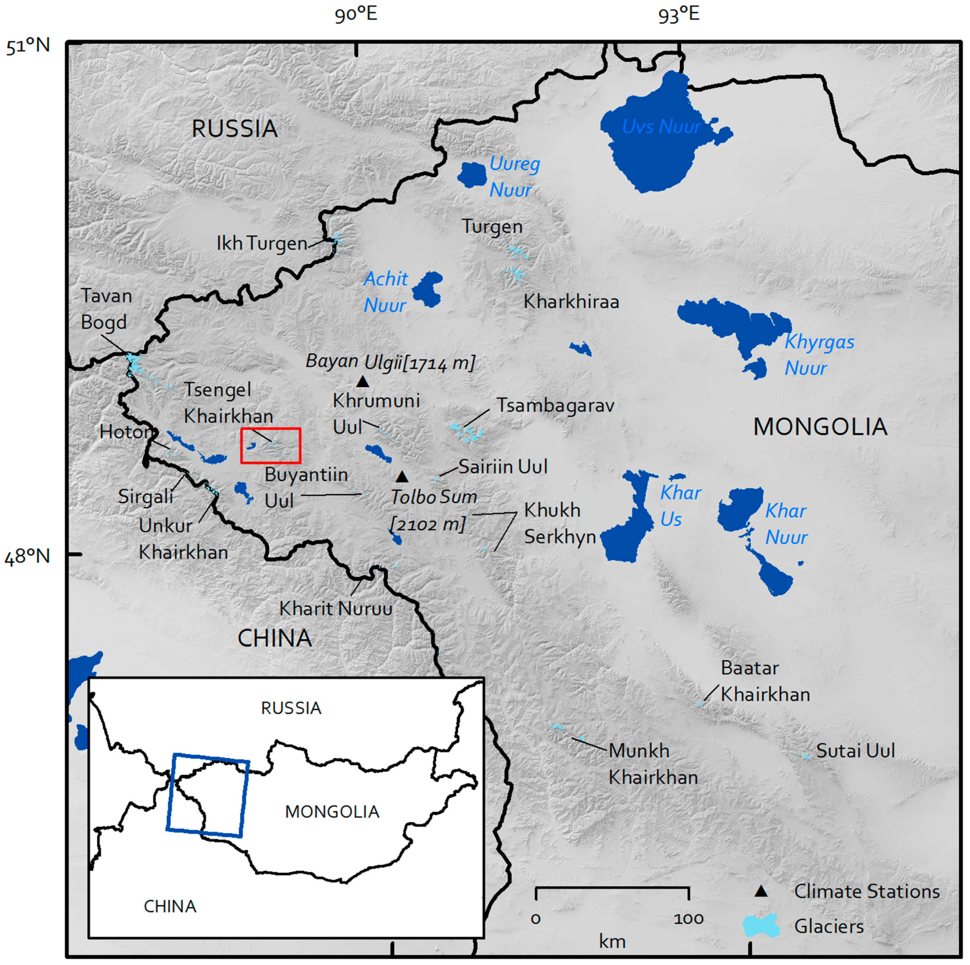
3. Study Area
4. Methods
5. Results
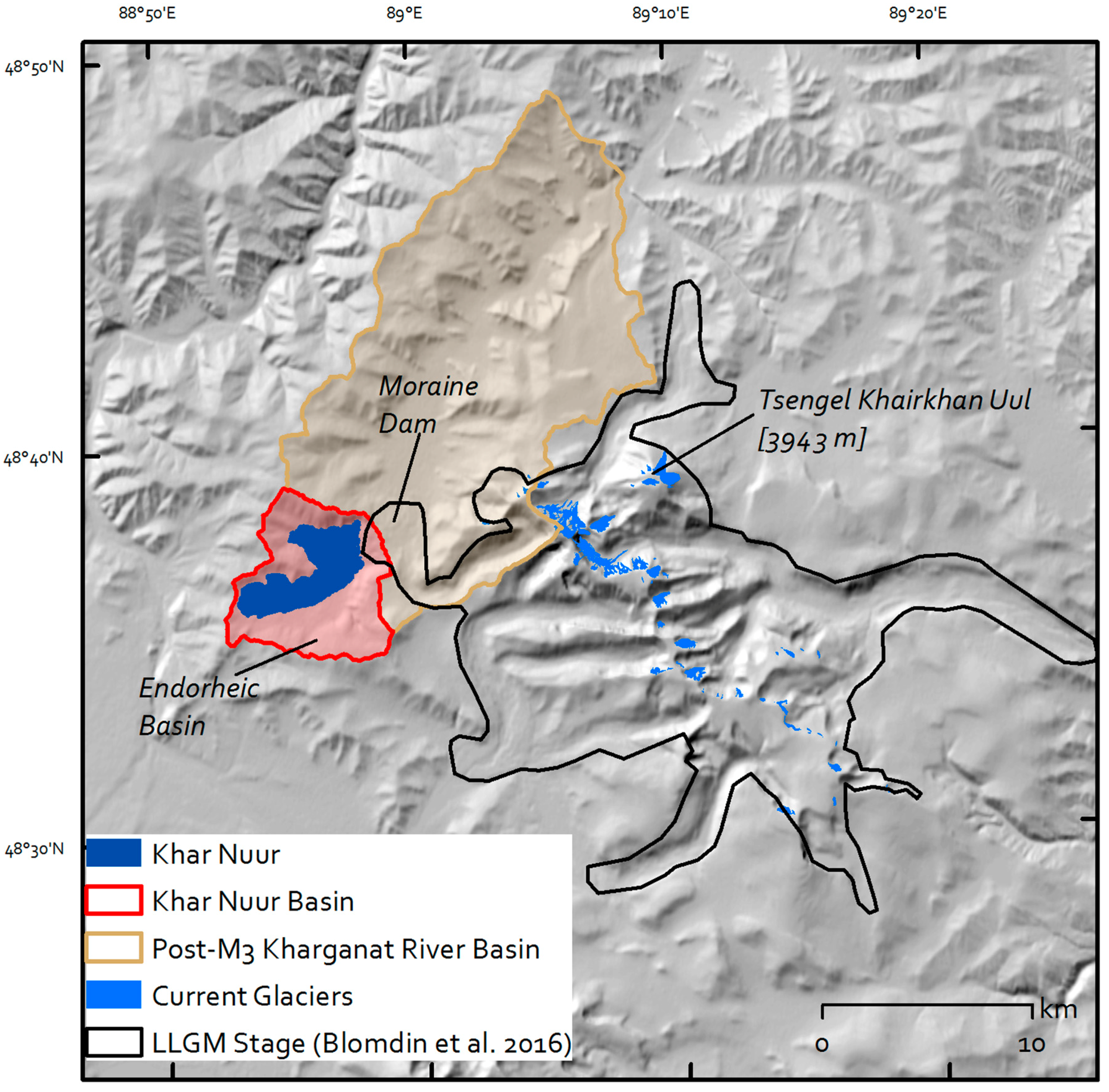
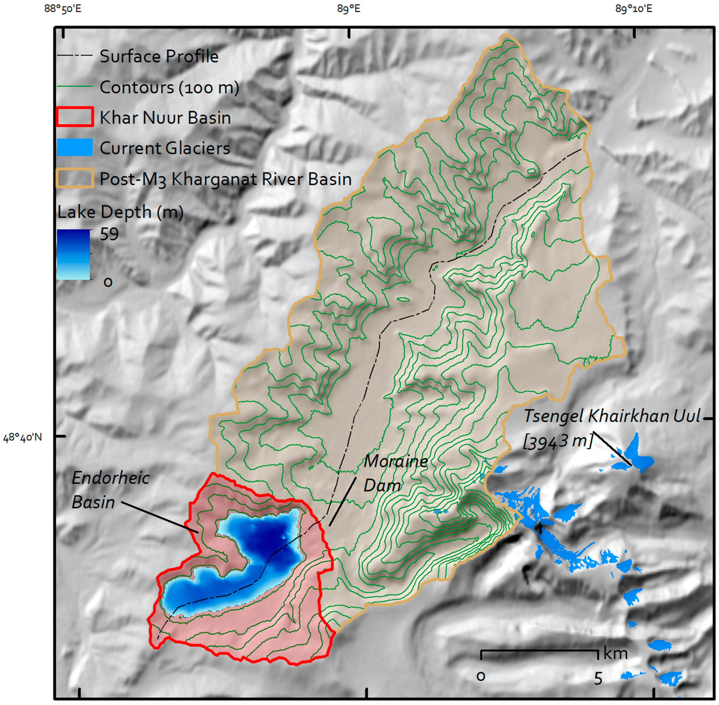
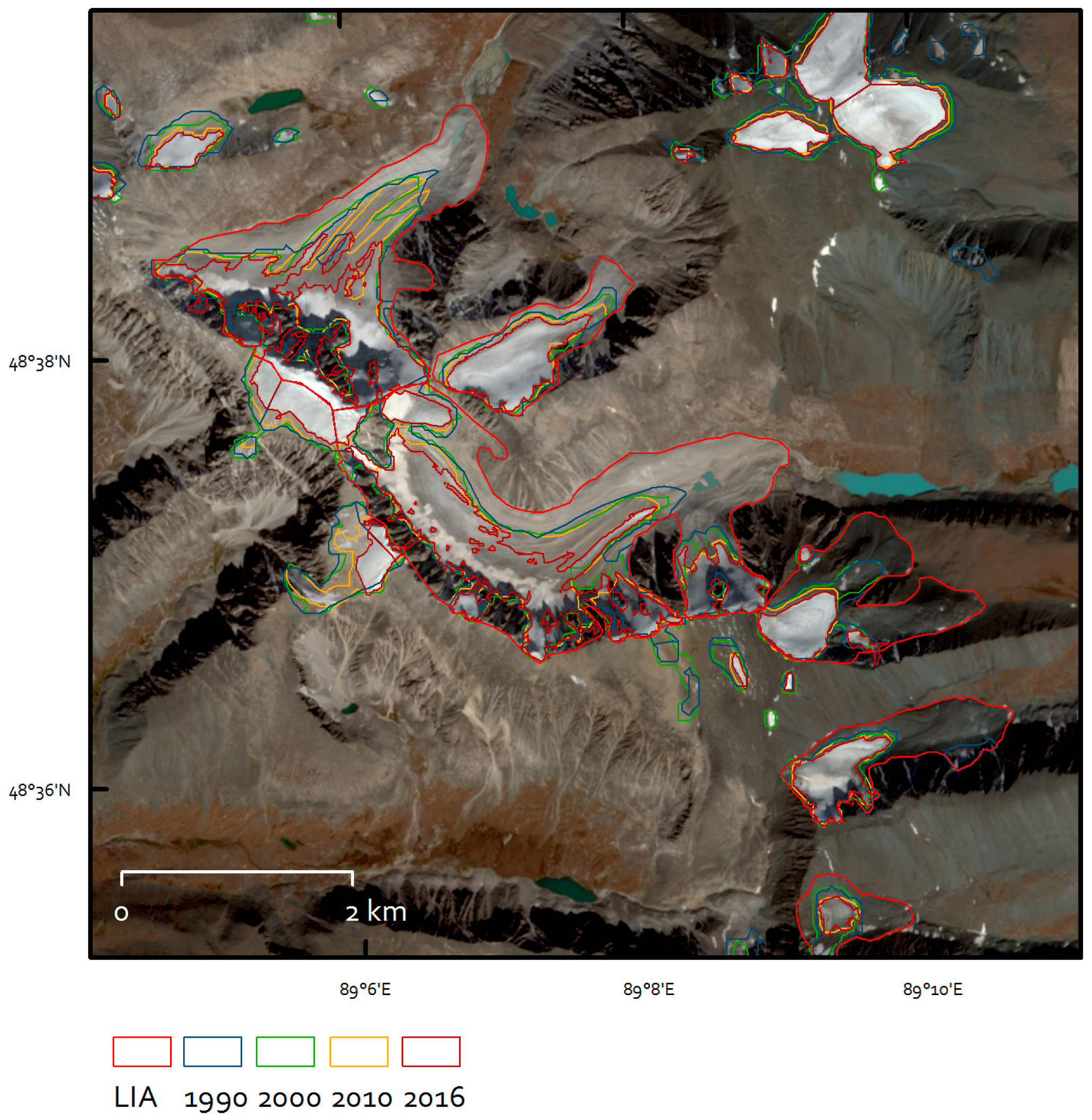
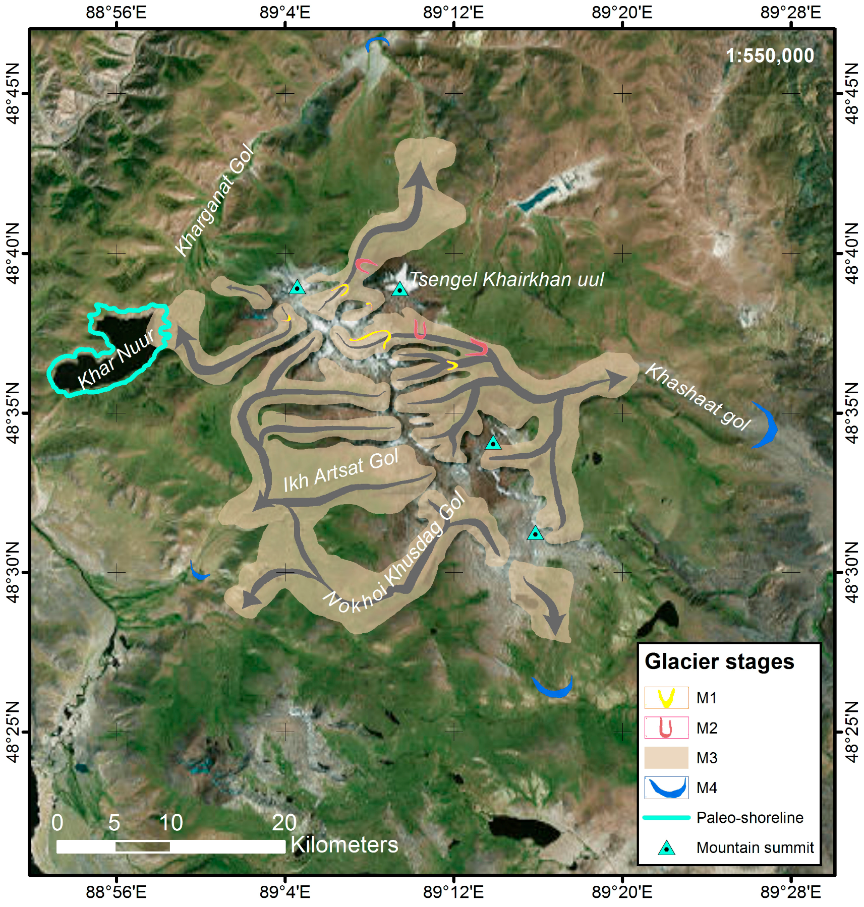
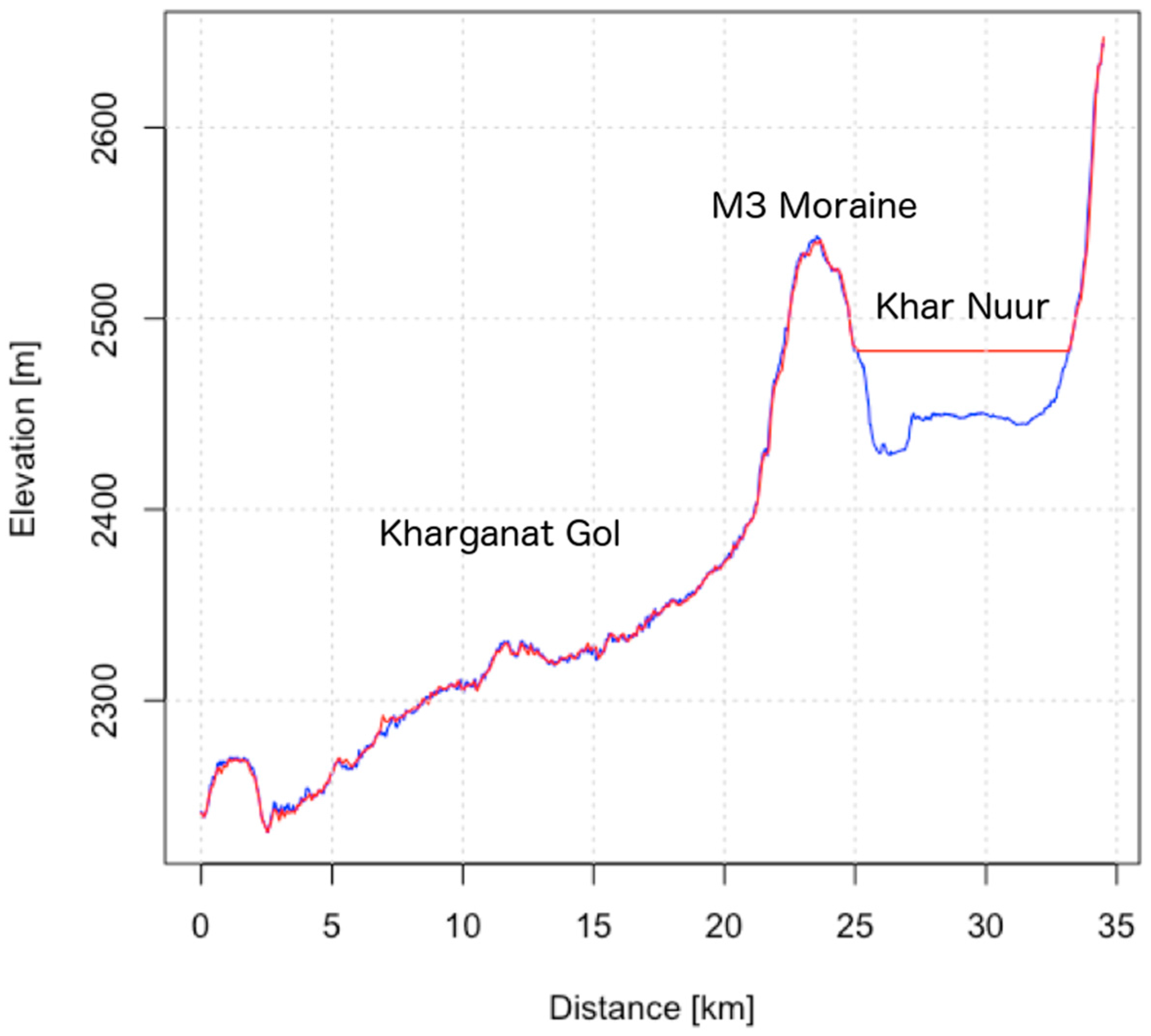
5.1. Geomorphology and Glaciers
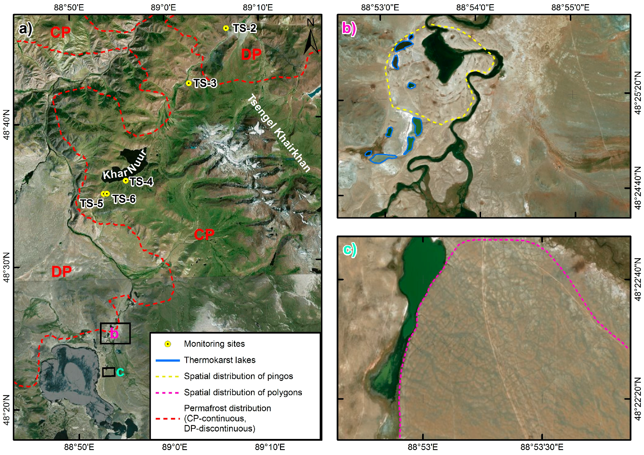
5.2. Permafrost
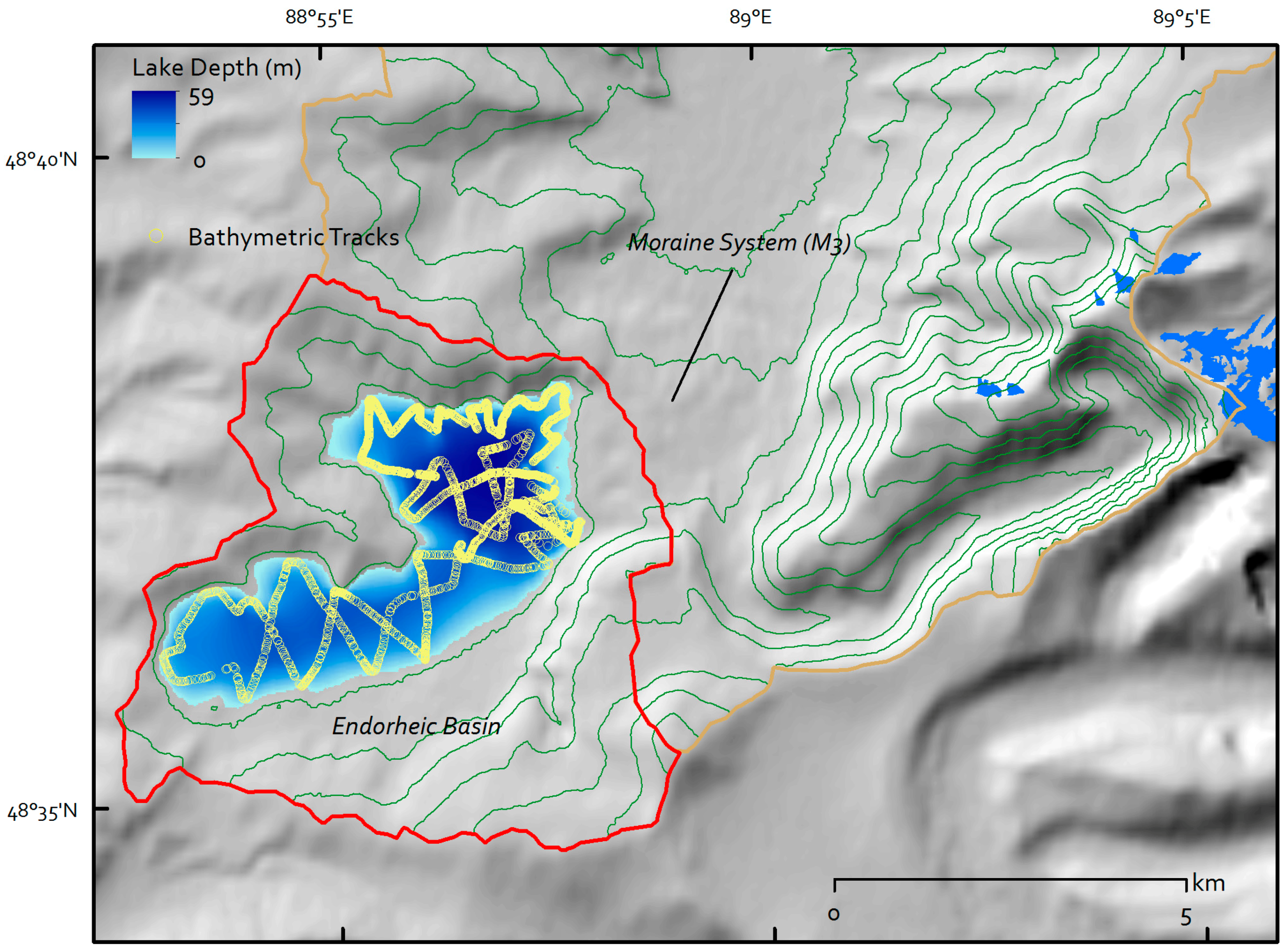
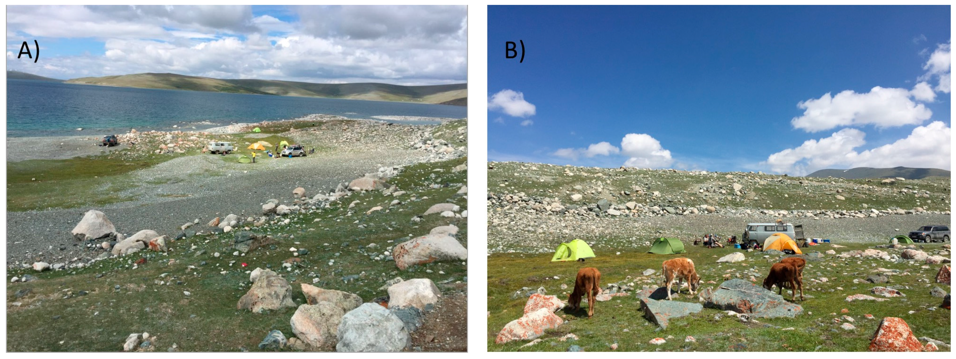
5.3. Khar Nuur Characteristics
5.4. Climate
6. Discussion
6.1. Glacial Chronology
6.2. Recent Permafrost Conditions
6.3. Khar Nuur Level Changes
6.4. Recent Climate Change
7. Conclusions
Acknowledgments
Author Contributions
Conflicts of Interest
References and Notes
- Dashdeleg, N.; Evilkhaan, R.; Khishigsuren, P. Modern glaciers in the Altai Mountains. Proc. Inst. Meteorol. Hydrol. 1983, 8, 121–126. (In Mongolian) [Google Scholar]
- Batnasan, N. Freshwater Issues in Mongolia. In Proceedings of the National Seminar on IRBM in Mongolia, Ulaanbaatar, Mongolia, 24–25 September 2003; pp. 53–61. [Google Scholar]
- Batbold, K.; Tuul, Z.; Oyun, B. Access to Water and Sanitation Services in Mongolia; United Nations: New York, NY, USA, 2004. [Google Scholar]
- Kamp, U.; Krumwiede, B.; McManigal, K.; Pan, C.G.; Walther, M.; Dashtseren, A. The Glaciers of Mongolia. Occas. Pap. Inst. Arct. Alp. Res. 2013, 61, 43. [Google Scholar]
- Ganiushkin, D.; Christyakov, K.; Kunaeva, E. Fluctuations of glaciers in the southeast Russian Altai and northwest Mongolia mountains since the Little Ice Age maximum. Environ. Earth Sci. 2015, 74, 1883–1904. [Google Scholar] [CrossRef]
- Kamp, U.; Pan, C.G. Inventory of glaciers in Mongolia, derived from Landsat imagery from 1989 to 2011. Geogr. Ann. Ser. A Phys. Geogr. 2015, 97, 653–669. [Google Scholar] [CrossRef]
- Earl, L.; Gardner, A. A satellite-derived glacier inventory for North Asia. Ann. Glaciol. 2016, 57, 50–60. [Google Scholar] [CrossRef]
- Bussemer, S. Jungquartäre Vergletscherung im Bergaltai und in angrenzenden Gebirgen: Analyse des Forschungstandes. Mitt. Geogr. Ges. München 2000, 85, 45–64. (In German) [Google Scholar]
- Lehmkuhl, F.; Klinge, M.; Stauch, G. The extent of Late Pleistocene glaciations in the Altai and Khangai Mountains. In Quaternary Glaciations: Extent and Chronologies, Part III: South America, Asia, Africa, Australia, Antarctica; Ehlers, J., Gibbard, P.L., Eds.; Elsevier: Amsterdam, The Netherlands, 2004; pp. 243–254. [Google Scholar]
- Lehmkuhl, F.; Klinge, M.; Stauch, G. The extent and timing of Late Pleistocene Glaciations in the Altai and neighboring mountains systems. In Development in Quaternary Science: Extent and Chronology—A Closer Look; Ehlers, J., Gibbards, L., Eds.; Elsevier: Amsterdam, The Netherlands, 2011; Volume 15, pp. 967–979. [Google Scholar]
- Blomdin, R.; Heyman, J.; Stroeven, A.P.; Hättestrand, C.; Harbor, J.M.; Gribenski, N.; Jansson, K.N.; Petrakov, D.A.; Ivanov, M.N.; Orkhonselenge, A.; et al. Glacial geomorphology of the Altai and Western Sayan Mountains, Central Asia. J. Maps 2016, 12, 123–136. [Google Scholar] [CrossRef]
- Lehmkuhl, F.; Klinge, M.; Rother, H.; Hülle, D. Distribution and timing of Holocene and late Pleistocene glacier fluctuations in western Mongolia. Ann. Glaciol. 2016, 57, 169–178. [Google Scholar] [CrossRef]
- Pan, C.G.; Pope, A.; Kamp, U.; Dashtseren, A.; Walther, M.; Syromyatina, M.V. Glacier recession in the Altai Mountains of Mongolia from 1990–2016. Geogr. Ann. Ser. A Phys. Geogr. in review.
- Batima, P.; Batnasan, N.; Lehner, B. The Freshwater Systems of Western Mongolia’s Great Lakes Basin: Opportunities and Challenges in the Face of Climate Change; World Wildlife Fund (WWF) Mongolia Programme Office: Ulaanbaator, Mongolia, 2004; p. 59. [Google Scholar]
- Baast, P. Modern Glaciers of Mongolia; Unpublished Report; Institute of Meteorology and Hydrology: Ulaanbaatar, Mongolia, 1998; p. 162. (In Russian) [Google Scholar]
- Zhang, Y.; Enomoto, H.; Ohata, T.; Kitabata, H.; Kadota, T.; Hirabayashi, Y. Projections of glacier change in the Altai Mountains under twenty-first century climate scenarios. Clim. Dyn. 2016, 47, 2935–2953. [Google Scholar] [CrossRef]
- Dashtseren, A.; Ishikawa, M.; Iijima, Y.; Yamkin, J. Temperature regimes of the active layer and seasonally frozen ground under a forest-steppe mosaic, Mongolia. Permafr. Periglac. Process. 2014, 25, 295–306. [Google Scholar] [CrossRef]
- Dashtseren, A.; Ishikawa, M.; Iijima, Y.; Yamkin, J.; Sharkhuu, N.; Gansukh, Y.; Temuujin, K.; Amarbayasgalan, Y.; Tsogterdene, G.; Undrakhtsetseg, T. Characteristics of permafrost at local and regional scales: The Altai and Khentii mountains, Mongolia. In Proceedings of the Eleventh International Conference on Permafrost, Potsdam, Germany, 20–24 June 2016. [Google Scholar]
- Saruulzaya, A.; Ishikawa, M.; Jambaljav, Y. Thermokarst lake changes in the southern fringe of Siberian permafrost region in Mongolia using Corona, Landsat, and ALOS satellite imagery from 1962 to 2007. Adv. Remote Sens. 2016, 5, 215–231. [Google Scholar] [CrossRef]
- Ishikawa, M.; Sharkhuu, N.; Zhang, Y.; Kadota, T.; Ohata, T. Ground thermal and moisture conditions at the southern boundary of discontinuous permafrost, Mongolia. Permafr. Periglac. Process. 2005, 16, 209–216. [Google Scholar] [CrossRef]
- Sharkhuu, A.; Sharkhuu, N.; Etzelmüller, B.; Heggem, E.S.F.; Nelson, F.E.; Shiklomanov, N.I.; Goulden, C.E.; Brown, J. Permafrost monitoring in the Hovsgol mountain region, Mongolia. J. Geophys. Res. Earth Surf. 2007, 112, F02S06. [Google Scholar] [CrossRef]
- Etzelmüller, B.; Heggem, E.S.F.; Sharkhuu, N.; Frauenfelder, R.; Kääb, A.; Goulden, C. Mountain permafrost distribution modeling using a multi-criteria approach in the Hövsgöl Area, Northern Mongolia. Permafr. Periglac. Process. 2006, 17, 91–104. [Google Scholar] [CrossRef]
- Borodavko, P.S. Pleistocene lake level changes in Western Mongolia. EGU General Assembly. In Proceedings of the EGU General Assembly Conference Abstracts, Vienna, Austria, 19–24 April 2009. Abstract 2009 EGU GA.11.1805B. [Google Scholar]
- Mursaev, E.M. Die Mongolische Volksrepublik: Physisch-Geographische Beschreibung; VEB Herman Haack Geographisch-Kartographische Anstalt: Gotha, Germany, 1954. (In German) [Google Scholar]
- Krengel, M. Discourse on history of vegetation and climate in Mongolia: Palynological report of sediment core Bayan Nuur I (NW-Mongolia). Berl. Geowiss. Abh. A 2000, 205, 80–84. [Google Scholar]
- Naumann, S.; Walther, M. Mid-Holocene lake level fluctuations of Bayan Nuur (North-West Mongolia). Marbg. Geogr. Schr. 2000, 135, 15–27. [Google Scholar]
- Walther, M.; Wünnemann, B.; Tschimeksaichan, A. Seen und Paleoseen in der Mongolei und Nordwestchina. Petermanns Geogr. Mitt. 2003, 147, 44–51. (In German) [Google Scholar]
- Walther, M.; Enkhjargal, V.; Gegeensuvd, T.; Odbaatar, E. Environmental changes of Orog Nuur (Bayan Khongor Aimag, South Mongolia): Lake deposits, paleo-shorelines and vegetation history. Erforsch. Biol. Ressour. Mong. (Explor. Biol. Resour. Mong.) 2016, 13, 37–57. [Google Scholar]
- Walther, M. Befunde zur jungquartären Klimaentwicklung rekonstruiert am Beispiel der Seespiegelstände des Uvs Nuur Beckens (NW Mongolei). Die Erde 1999, 130, 131–150. (In German) [Google Scholar]
- Walther, M. Aspects of Lake Research in Mongolia. Sci. Rep. Natl. Univ. Mong. 2002, 191, 18–23. [Google Scholar]
- Fedokov, A.P.; Chebykin, E.P.; Yu, S.M.; Vorobyova, S.S.; Yu, O.E.; Golobokova, L.P.; Pogodaeva, T.V.; Zheleznyakova, T.O.; Grachev, M.A.; Tomurhuu, D.; et al. Changes in volume and salinity of Lake Khubsugul (Mongolia) in response to global climate changes in the upper Pleistocene and the Holocene. Paleogeogr. Paleoclimatol. Paleoecol. 2004, 209, 245–257. [Google Scholar] [CrossRef]
- Schwanghart, W.; Schütt, B.; Walther, M. Holocene climate evolution of the Ugii Nuur basin, Mongolia. Adv. Atmos. Sci. 2008, 25, 986–998. [Google Scholar] [CrossRef]
- Walther, M.; Gegeensuvd, T. Ugii Nuur: Paleo-environmental studies of lake level fluctuations and Holocene climate change. Geogr. Oekol. 2005, 2, 36, (In German and Mongolian). [Google Scholar]
- Tao, S.; Fang, J.; Zhao, X.; Zhao, S.; Shen, H.; Hu, H.; Tang, Z.; Wang, Z.; Gua, Q. Rapid loss of lakes on the Mongolian Plateau. Proc. Natl. Acad. Sci. USA 2015, 112, 2281–2286. [Google Scholar] [CrossRef] [PubMed]
- Kang, S.; Hong, S.Y. Assessing seasonal and inter-annual variations of lake surface areas in Mongolia during 2000–2011 using minimum composite MODIS NDVI. PLoS ONE 2016, 11. [Google Scholar] [CrossRef] [PubMed]
- Szuminska, D. Changes in surface area of the Böön Tsagaan and Orog lakes (Mongolia, Valley of the Lakes, 1973–2013) compared to climate and permafrost changes. Sediment. Geol. 2016, 340, 62–73. [Google Scholar] [CrossRef]
- Kang, S.; Lee, G.; Togtokh, C.; Jang, K. Characterizing regional precipitation-driven lake area change in Mongolia. J. Arid Land 2015, 7, 146–158. [Google Scholar] [CrossRef]
- Kumagai, M.; Urabe, J.; Goulden, C.; Soninkhishig, N.; Hayakawa, K.; Tsujimura, S.; Ishikawa, K.; Hadbaatar, D.; Hayami, Y.; Sekino, T.; et al. Recent rise in water level at Lake Hövsgög in Mongolia. In The Geology, Biodiversity and Ecology of Lake Hövsgöl (Mongolia); Goulden, C.E., Sitnikova, T., Gelhaus, J., Boldgiv, B., Eds.; Backhuys: Leiden, The Netherlands, 2006; pp. 77–91. [Google Scholar]
- Sevastianov, D.W.; Drobiuk, I.N. History of water systems in Mongolia. J. Russ. Geogr. Assoc. 1992, 124, 123–138. [Google Scholar]
- Dorofeyuk, N.I.; Tarasov, P.E. Vegetation and lake levels in Northern Mongolia in the last 12500 years as indicated by data of pollen and diatom analyses. Stratigr. Geol. Correl. 1998, 6, 70–81. [Google Scholar]
- Tarasov, P.; Harrison, S.P. Lake status from former Soviet Union and Mongolia: A continental scale synthesis. Paläoklimafroschung 1998, 25, 115–130. [Google Scholar]
- Tarasov, P.; Dorofeyuk, N.; Metel’tseva, E. Holocene vegetation and climate changes in Hoton-Nur basin, northwest Mongolia. Boreas 2000, 29, 117–126. [Google Scholar] [CrossRef]
- Walther, M. Paleo-environmental changes in the Uvs Nuur Basin (Northwest Mongolia). Erforsch. Biol. Ressour. Mong. (Explor. Biol. Resour. Mong.) 2010, 11, 267–279. [Google Scholar]
- Dagvadorj, D.; Mijidorj, R.; Natsagdorj, L. Climate change in Mongolia. Pap. Meteorol. 1994, 17, 3–10. [Google Scholar]
- Batima, P.; Natsagdorj, L.; Gombluudev, P.; Erdenetsetseg, B. Observed Climate Change in Mongolia. Nairobi: Assessments of Impacts and Adaptations to Climate Change (AIACC); Working Papers. 2005; Volume 13, p. 26. [Google Scholar]
- Tserensodnom, J. Catalogue of the Mongolian Lakes. 2000; 69. (In Mongolian) [Google Scholar]
- Jansen, A. Modellierung von Klimapametern zur Bestimmung von charakteristischen Gletscherkennwerten für das Turgen-Kharkhiraa-Gebrigsmassiv (Mongolia). Ph.D. Thesis, Department of Geography and Geoecology, Technical University of Aachen, Aachen, Germany, 2010; p. 143. (In German). [Google Scholar]
- Bishop, M.P.; Olsenholler, J.A.; Shroder, J.F.; Barry, R.G.; Raup, H.; Bush, A.B.G.; Copland, L.; Dwyer, J.L.; Fountain, A.G.; Haeberli, W.; et al. Global Land Ice Measurements from Space (GLIMS): Remote Sensing and GIS Investigations of the Earth’s Cryosphere. Geocarto Int. 2004, 19, 37–41. [Google Scholar] [CrossRef]
- Bhambri, R.; Bolch, T. Glacier mapping: A review with special reference to the Indian Himalayas. Prog. Phys. Geogr. 2009, 33, 672–704. [Google Scholar] [CrossRef]
- Paul, F.; Barrand, N.E.; Baumann, S.; Berthier, E.; Bolch, T.; Casey, K.; Nosenko, G.; Frey, H.; Joshi, S.P.; Konovalov, V.; et al. On the accuracy of glacier outlines derived from remote-sensing data. Ann. Glaciol. 2013, 54, 171–182. [Google Scholar] [CrossRef] [Green Version]
- Bolch, T.; Menounos, B.; Wheate, R. Landsat-based inventory of glaciers in western Canada, 1985–2005. Remote Sens. Environ. 2010, 114, 127–137. [Google Scholar] [CrossRef]
- Racoviteanu, A.E.; Paul, F.; Raup, B.; Khalsa, S.J.S.; Armstrong, R. Challenges and recommendations in mapping of glacier parameters from space: Results of the 2008 Global Land Ice Measurements from Space (GLIMS) workshop, Boulder, Colorado, USA. Ann. Glaciol. 2009, 50, 53–69. [Google Scholar] [CrossRef] [Green Version]
- Frey, H.; Paul, F.; Strozz, T. Compilation of a glacier inventory for the western Himalayas from satellite data: Methods, challenges, and results. Remote Sens. Environ. 2012, 124, 832–884. [Google Scholar] [CrossRef] [Green Version]
- Raup, B.; Kääb, A.; Kargel, J.S.; Bishop, M.P.; Hamilton, G.; Lee, E.; Paul, F.; Rau, F.; Soltesz, D.; Khalsa, S.J.S.; et al. Remote sensing and GIS technology in the Global Land Ice Measurements from Space (GLIMS) project. Comput. Geosci. 2007, 33, 104–125. [Google Scholar] [CrossRef]
- Höfer von Heimhalt, H. Gletscher-und Eiszeitstudien. Sitzungsberichte der Akademie der Wissenschaften in Wien Mathematisch-Naturwissenschaftliche Klasse Abteilung I Biologie Mineralogie Erdkunde 1879, 79, 331–367. (In German) [Google Scholar]
- Patzelt, G. Statistik der Längenmessungen an den Österreichischen Gletschern 1960 bis 1975. Z. Gletsch. Glazialgeol. 1976, 12, 91–94. (In German) [Google Scholar]
- Gross, G.; Kerschner, H.; Patzelt, G. Methodische Untersuchungen über die Schneegrenze in alpinen Gletschergebieten. Z. Gletsch. Glazialgeol. 1976, 12, 223–251. [Google Scholar]
- Lichtenecker, N. Die gegenwärtige und die eiszeitliche Schneegrenze in den Ostalpen. In Verhandlungen der III. Internationalen Quartär-Konferenz Wien 1936; Geologische Landesanstalt: Vienna, Austria, 1938; pp. 141–147. (In German) [Google Scholar]
- Jambaljav, Y.; Gansukh, Y.; Temuujin, K.; Tsogterdene, G.; Undrakhtsetseg, T.; Saruulzaya, A.; Amarbayasgalan, Y.; Dashtseren, A.; Narangerel, S. Permafrost Map of Mongolia (1:1,000,000); Gazriin Zurag: Ulaanbaatar, Mongolia, 2016. [Google Scholar]
- Pötsch, S.; Rother, H.; Lorenz, S.; Walther, M.; Lehmkuhl, F. Timing of late Pleistocene glaciation in Mongolia: Surface exposure dating reveals a differentiated pattern of ice advances. EGU General Assembly. Geophys. Res. Abstr. 2015, 17, EGU2015-4815-1. [Google Scholar]
- Rother, H.; Lehmkuhl, F.; Fink, D.; Nottebaum, V. Surface exposure dating reveals MIS-3 glacial maximum in the Khangai Mountains of Mongolia. Quat. Res. 2014, 82, 297–308. [Google Scholar] [CrossRef]
- Zhao, J.; Harbor, J.M.; Lai, Z. Quaternary glacial chronology of the Kanas River Valley, Altai Mountains, China. Quat. Int. 2013, 311, 44–53. [Google Scholar] [CrossRef]
- Klinge, M.; Lehmkuhl, F. Geomorphology of the Tsetseg Nuur basin, Mongolian Altai: Lake development, fluvial sedimentation and aeolian transport in a semi-arid environment. J. Maps 2013, 9, 361–366. [Google Scholar] [CrossRef]
- Walther, M. Paläoklimatische Untersuchungen zur jungpleistozänen Landschaftsentwicklung im Changai-Bergland und in der nördlichen Gobi (Mongolei). Petermanns Geogr. Mitt. 1998, 142, 207–217. (In German) [Google Scholar]
- Grunert, J.; Lehmkuhl, F.; Walther, M. Paleoclimatic evolution of the Uvs Nuur basin and adjacent areas (Western Mongolia). Quat. Int. 2000, 65–66, 171–192. [Google Scholar] [CrossRef]


| Borehole | Location | Slope | Elevation (m a.s.l.) | Ground Surface Conditions | Dominant Ground Material and Depth | Sensor Depths (m) | MGST (°C) | MAGT (°C) | ALT (m) | FDD | TDD |
|---|---|---|---|---|---|---|---|---|---|---|---|
| TS-2 | 48°46′23″ N 89°06′33″ E | valley (3–5°) | 2240 | poorly vegetated; pebbles and debris | dry sandy gravels (0–5 m), silt with less gravels (5–10 m) | 0, 1, 2, 3, 4, 6, 10 | −1.0 to 1.0 | −0.1 to −0.3 | 5.9–6.0 | −1998 to −2459 | 2211 to 2276 |
| TS-3 | 48°42′36″ N 89°02′27″ E | valley (3–5°) | 2338 | poorly vegetated; pebbles and debris | dry sandy gravels (0–6 m), silt with less gravels (6–10 m) | 0, 1, 2, 3, 4, 6, 8, 10 | −0.8 to 2.4 | −2.3 | 3.4–3.7 | −1950 to −2455 | 1778 to 1836 |
| TS-4 | 48°35′53″ N 88°55′32″ E | N-slope (3–5°) | 2500 | poorly vegetated; pebbles and debris | silt with less gravels (0–10 m) | 0, 1, 2, 3, 4, 6, 10 | −2.7 to −4.2 | −3.3 | 2.2–2.4 | −2249 to −3001 | 1303 to 1517 |
| TS-5 | 48°35′00″ N 88°53′10″ E | SE-slope (5–7°) | 2567 | more heavily vegetated; debris | sandy gravels (0–4.7 m), silt with less gravels (4.7–10 m) | 0, 1, 2, 3, 4, 6, 8, 10 | −2.2 to −2.4 | −2.3 to −2.4 | 2.0–2.3 | −2093 to −2366 | 1311 to 1587 |
| TS-6 | 48°35′00″ N 88°53′31″ E | S-slope (5–7°) | 2556 | more heavily vegetated; debris | sandy gravels (0–1 m), silt with less gravels (1–10 m) | 0, 1, 2, 3, 4, 6, 8, 9 | −2.6 to −3.0 | −2.4 | 2.1–2.2 | −2253 to −2393 | 1291 to 1305 |
| Lake Characteristics | This Study | Tserensodnom (2000) [46] |
|---|---|---|
| Catchment area | 44.8 km2 | 50.0 km2 |
| 1948/1970, 1970s/1980s * | ||
| Elevation | 2488 m a.s.l. | 2494 m a.s.l. |
| Surface area | 13.9 km2 | 14.2 km2 |
| Maximal depth | - | 30 m |
| Mean depth | - | 17 m |
| Lake volume | - | 0.24 km3 |
| 2006 | ||
| Elevation | 2487 m a.s.l. | - |
| Surface area | 13.8 km2 | - |
| 2010 | ||
| Elevation | 2486 m a.s.l. | - |
| Surface area | 13.5 km2 | |
| 2016 | ||
| Elevation | 2487 m a.s.l. | - |
| Catchment area | 44.8 km2 | - |
| Surface area | 13.8 km2 | - |
| Maximal depth | 58 m | - |
| Mean depth | 28 m | - |
| Station | Elevation (m a.s.l.) | Temperature (°C) | Precipitation (mm) | Snow Depth (cm) | Ice Days (Tmax < 0°) | Frost Days (Tmin < 0°) | Frost Change Frequency |
|---|---|---|---|---|---|---|---|
| Bayan Ulgii | 1714 | 1.5 | 116.3 | 88 | 116 | 216 | 101 |
| Tolbo Sum | 2102 | −2.4 | 129.4 | 255 | 140 | 247 | 205 |
| Moraine System | Elevation (m a.s.l.) | ELA (m a.s.l.) | Description | Age | MIS | Lehmkuhl et al. (2016) [12] |
|---|---|---|---|---|---|---|
| M4 | 2248 | 2898–2918 | maximum extent of Late Pleistocene glaciers; single glacigenic blocks; connected with outwash plain | >71/>97 ka * | MIS 4/5 | M2a+b |
| M3 | 2473 | 2950–3059 | distinct terminal moraines and lateral moraines; kettle holes; block-rich terminal walls; basal till with hummocky relief; eskers; moraine system blocking the upper Kharganat Gol | >10.4 ka * | MIS 2 | M1a-c M1c: LLGM |
| M2 | 2778 | 3212–3130 | different moraine stages down valley of glacier tongue basins and rock glaciers | YD/early Holocene | MIS 1 | - |
| M1 | 3056 | 3244–3293 | non-vegetated and soil-free distinct terminal and lateral moraines | LIA | MIS 1 | LIA |
| Glacier Area | 1990 | 1990–2000 | 2000 | 2000–2010 | 2010 | 2010–2016 | 2016 |
|---|---|---|---|---|---|---|---|
| (km2) | 14.2 | −0.9 | 13.3 | −3.0 | 10.3 | −2.1 | 8.2 |
| (%) | - | −6.3 | - | −22.6 | - | −20.4 | - |
© 2017 by the authors. Licensee MDPI, Basel, Switzerland. This article is an open access article distributed under the terms and conditions of the Creative Commons Attribution (CC BY) license (http://creativecommons.org/licenses/by/4.0/).
Share and Cite
Walther, M.; Dashtseren, A.; Kamp, U.; Temujin, K.; Meixner, F.; Pan, C.G.; Gansukh, Y. Glaciers, Permafrost and Lake Levels at the Tsengel Khairkhan Massif, Mongolian Altai, During the Late Pleistocene and Holocene. Geosciences 2017, 7, 73. https://doi.org/10.3390/geosciences7030073
Walther M, Dashtseren A, Kamp U, Temujin K, Meixner F, Pan CG, Gansukh Y. Glaciers, Permafrost and Lake Levels at the Tsengel Khairkhan Massif, Mongolian Altai, During the Late Pleistocene and Holocene. Geosciences. 2017; 7(3):73. https://doi.org/10.3390/geosciences7030073
Chicago/Turabian StyleWalther, Michael, Avirmed Dashtseren, Ulrich Kamp, Khurelbaatar Temujin, Franz Meixner, Caleb G. Pan, and Yadamsuren Gansukh. 2017. "Glaciers, Permafrost and Lake Levels at the Tsengel Khairkhan Massif, Mongolian Altai, During the Late Pleistocene and Holocene" Geosciences 7, no. 3: 73. https://doi.org/10.3390/geosciences7030073